Bridge Statistics for Leavenworth, Washington (WA)
Condition, Traffic, Stress, Structural Evaluation, Project Costs
- National Bridge Inventory (NBI) Statistics
- 18Number of bridges
- 256ft / 78.2mTotal length
- $57,350,000Total costs
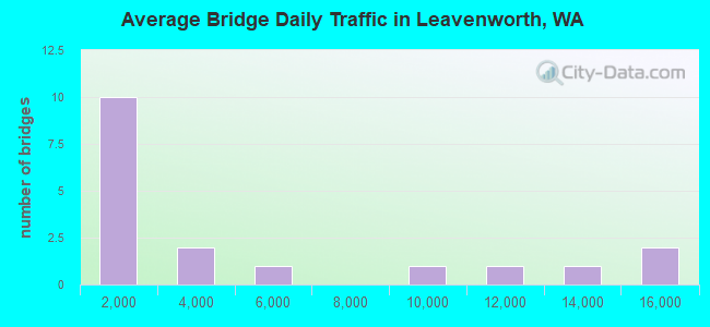
- 78,184Total average daily traffic
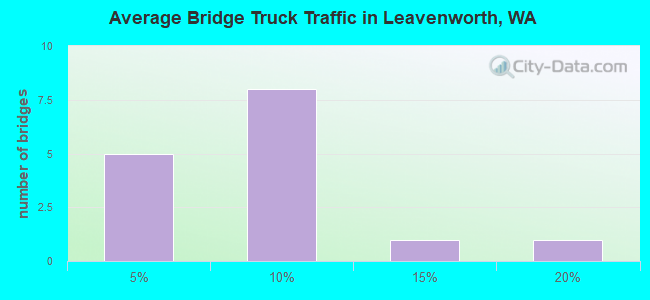
- 6,366Total average daily truck traffic
- National Bridge Inventory (NBI) Registered Bridges for Leavenworth
- No street view available for this location
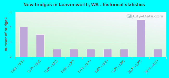
- New bridges - historical statistics
- 41930-1939
- 31940-1949
- 11950-1959
- 11960-1969
- 11970-1979
- 11980-1989
- 11990-1999
- 52000-2009
- 12010-2019

- Reconstructed bridges - Historical Statistics
- 11940-1949
- 11950-1959
- 11960-1969
- 21970-1979
- 11980-1989
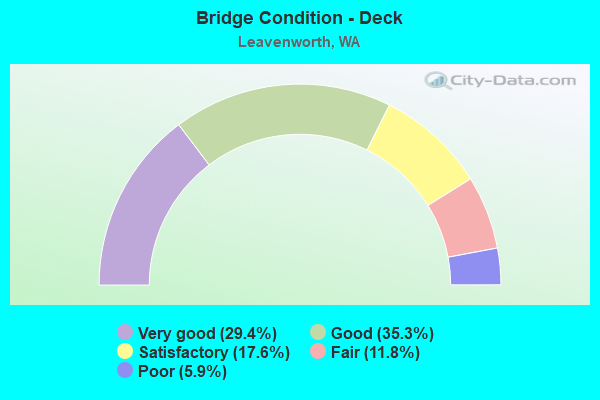
- Bridge Condition - Deck
- 29.4%Very good
- 35.3%Good
- 17.6%Satisfactory
- 11.8%Fair
- 5.9%Poor
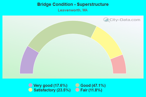
- Bridge Condition - Superstructure
- 17.6%Very good
- 47.1%Good
- 23.5%Satisfactory
- 11.8%Fair
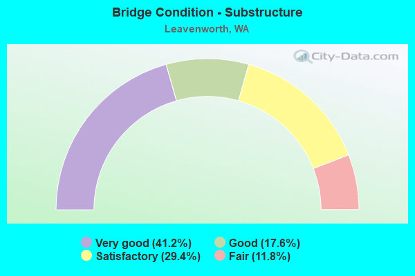
- Bridge Condition - Substructure
- 41.2%Very good
- 17.6%Good
- 29.4%Satisfactory
- 11.8%Fair
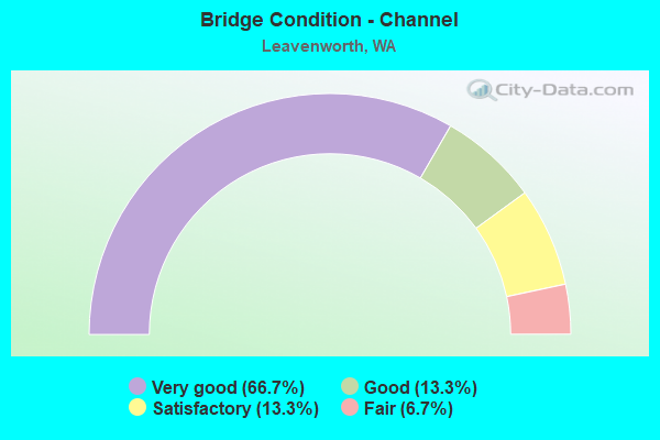
- Bridge Condition - Channel
- 66.7%Very good
- 13.3%Good
- 13.3%Satisfactory
- 6.7%Fair
Find on map >> Show street view
Structure Number: 13225-00038, Location: 0.1 MI ESE OF OFFICE (Lat: 47.558000, Lng: -120.672167), Route carried "on" structure: Federal lands road , Year Built: 1939, Year Reconstructed: 1960, Status: Posted for load, Structure Length: 2.68m (8.79ft), Average Daily Traffic: 10 (year 2020), Average Future Daily Traffic: 10 (year 2040), Features Intersected: ICICLE CANAL, Facility Carried by Structure: SERVICE ROAD
Minimum Vertical Clearance: 30.48m (100.00ft), Kilometerpoint: 0.161, Lanes on structure: 2, Owner: Bureau of Fish and Wildlife, Approaching Roadway Width: 4.9m (16.1ft), Material/Design: Steel, Design/Construction: Truss - Thru, Number Of Spans In Main Unit: 1, Length of Maximum Span: 25.3m (83.0ft), Curb or Sidewalk Widths: Left: 0.5m (1.6ft), Right: 0.2m (0.7ft), Curb-To-Curb Width: 5.5m (18.0ft), Out-to-Out Width: 6.0m (19.7ft)
Condition: Deck: Satisfactory, Superstructure: Satisfactory, Substructure: Fair, Channel: Good, Operating Rating: 29.0 metric tons, Method Used To Determine Operating Rating: Allowable Stress (AS), Inventory Rating: 20.9 metric tons, Method Used To Determine Inventory Rating: Allowable Stress (AS), Structural Evaluation: Somewhat better than minimum adequacy, Deck Geometry: Meets minimum limits, Waterway Adequacy: Better than present minimum criteria, Approach Roadway Alignment: Equal to present minimum criteria, Designated Inspection Frequency: Every 24 months, Critical Feature Inspection Frequency: Every 24 months, Inspection Date: July 2020, Critical Feature Inspection Date: July 2020, Deck Structure Type: Wood or Timber, Wearing Surface/Protective System: Wearing Surface: Bituminous
Find on map >> Show street view
Structure Number: 13225-00082, Location: 1.3 MI SSW OF THE OFFICE (Lat: 47.549500, Lng: -120.679000), Route carried "on" structure: Federal lands road , Year Built: 1939, Status: Open, Structure Length: 1.10m (3.61ft), Average Daily Traffic: 2 (year 2020), Average Future Daily Traffic: 2 (year 2040), Features Intersected: ICICLE CREEK, Facility Carried by Structure: SERVICE ROAD
Minimum Vertical Clearance: 30.48m (100.00ft), Kilometerpoint: 1.609, Lanes on structure: 1, Owner: Bureau of Fish and Wildlife, Approaching Roadway Width: 3.0m (9.8ft), Material/Design: Concrete, Design/Construction: Tee Beam, Number Of Spans In Main Unit: 1, Length of Maximum Span: 10.7m (35.1ft), Curb or Sidewalk Widths: Left: 0.4m (1.3ft), Right: 0.1m (0.3ft), Curb-To-Curb Width: 3.2m (10.5ft), Out-to-Out Width: 3.8m (12.5ft)
Condition: Deck: Fair, Superstructure: Satisfactory, Substructure: Good, Channel: Good, Operating Rating: 32.7 metric tons, Method Used To Determine Operating Rating: Field evaluation and documented engineering judgment, Inventory Rating: 18.1 metric tons, Method Used To Determine Inventory Rating: Allowable Stress (AS), Structural Evaluation: Somewhat better than minimum adequacy, Deck Geometry: High priority of replacement, Waterway Adequacy: Better than present minimum criteria, Approach Roadway Alignment: Meets minimum limits, Designated Inspection Frequency: Every 24 months, Inspection Date: July 2020, Deck Structure Type: Concrete Cast-file-Place, Wearing Surface/Protective System: Wearing Surface: Monolithic Concrete
Find on map >> Show street view
Structure Number: 13225-00083, Location: 0.2 MI E OF OFFICE (Lat: 47.557667, Lng: -120.669833), Route carried "on" structure: Federal lands road , Year Built: 1935, Year Reconstructed: 1991, Status: Posted for load, Structure Length: 4.42m (14.50ft), Average Daily Traffic: 2 (year 2020), Average Future Daily Traffic: 2 (year 2040), Features Intersected: ICICLE CREEK, Facility Carried by Structure: SERVICE ROAD
Minimum Vertical Clearance: 30.48m (100.00ft), Kilometerpoint: 0.161, Lanes on structure: 1, Owner: Bureau of Fish and Wildlife, Approaching Roadway Width: 3.7m (12.1ft), Material/Design: Concrete, Design/Construction: Slab, Number Of Spans In Main Unit: 12, Length of Maximum Span: 3.7m (12.1ft), Curb-To-Curb Width: 3.1m (10.2ft), Out-to-Out Width: 3.5m (11.5ft)
Condition: Deck: Satisfactory, Superstructure: Good, Substructure: Fair, Channel: Satisfactory, Operating Rating: 36.3 metric tons, Method Used To Determine Operating Rating: Field evaluation and documented engineering judgment, Inventory Rating: 32.7 metric tons, Method Used To Determine Inventory Rating: Field evaluation and documented engineering judgment, Structural Evaluation: Somewhat better than minimum adequacy, Deck Geometry: High priority of replacement, Waterway Adequacy: Better than present minimum criteria, Approach Roadway Alignment: Somewhat better than minimum adequacy, Designated Inspection Frequency: Every 24 months, Inspection Date: July 2020, Deck Structure Type: Other, Wearing Surface/Protective System: Wearing Surface: Monolithic Concrete
Find on map >> Show street view
Structure Number: 2614A, Location: 16.3 E JCT SR 207 (Lat: 47.594194, Lng: -120.640361), Route carried "on" structure: US 2, Year Built: 1940, Status: Open, Structure Length: 3.66m (12.01ft), Average Daily Traffic: 12,425 (year 2019), Truck Traffic: 7%, Average Future Daily Traffic: 15,605 (year 2039), Design Load: H 15, Features Intersected: ICICLE DITCH SPILLWAY
Minimum Vertical Clearance: 30+ m (98+ ft), Kilometerpoint: 162.608, Lanes on structure: 2, Base Highway Network: Yes, Owner: State Highway Agency, Approaching Roadway Width: 10.4m (34.1ft), Material/Design: Concrete continuous, Design/Construction: Tee Beam, Number Of Spans In Main Unit: 4, Length of Maximum Span: 14.6m (47.9ft), Curb-To-Curb Width: 9.1m (29.9ft), Out-to-Out Width: 9.8m (32.2ft)
Condition: Deck: Good, Superstructure: Good, Substructure: Satisfactory, Channel: Very good, Operating Rating: 17.5 metric tons, Method Used To Determine Operating Rating: Load and Resistance Factor Rating (LRFR) rating reported by rating factor(RF) method using HL-93 loadings, Inventory Rating: 13.6 metric tons, Method Used To Determine Inventory Rating: Load and Resistance Factor Rating (LRFR) rating reported by rating factor(RF) method using HL-93 loadings, Structural Evaluation: High priority of corrective action, Deck Geometry: High priority of corrective action, Waterway Adequacy: Equal to present desirable criteria, Approach Roadway Alignment: Equal to present desirable criteria, Length Of Structure Improvement: 3.66m (12.01ft), Designated Inspection Frequency: Every 24 months, Inspection Date: August 2021, Bridge Improvement Cost: $864,000, Roadway Improvement Cost: $173,000, Total Project Cost: $1,728,000 ( Estimate for 2014), Deck Structure Type: Concrete Cast-file-Place, Wearing Surface/Protective System: Wearing Surface: Bituminous, Membrane: Preformed Fabric
Find on map >> Show street view
Structure Number: 2614B, Location: 0.3 E JCT US 97 (Lat: 47.556500, Lng: -120.588444), Route carried "on" structure: US 2, Year Built: 1940, Year Reconstructed: 1962, Status: Open, Structure Length: 7.56m (24.80ft), Average Daily Traffic: 5,934 (year 2019), Truck Traffic: 7%, Average Future Daily Traffic: 7,453 (year 2039), Design Load: H 15, Features Intersected: PESHASTIN CREEK
Minimum Vertical Clearance: 30+ m (98+ ft), Kilometerpoint: 168.627, Lanes on structure: 2, Base Highway Network: Yes, Owner: State Highway Agency, Approaching Roadway Width: 10.7m (35.1ft), Skew: 3 degrees, Material/Design: Concrete continuous, Design/Construction: Tee Beam, Number Of Spans In Main Unit: 4, Length of Maximum Span: 23.5m (77.1ft), Curb or Sidewalk Widths: Left: 0.0m, Right: 0.9m (3.0ft), Curb-To-Curb Width: 9.3m (30.5ft), Out-to-Out Width: 9.4m (30.8ft)
Condition: Deck: Good, Superstructure: Fair, Substructure: Satisfactory, Channel: Very good, Operating Rating: 22.7 metric tons, Method Used To Determine Operating Rating: Load and Resistance Factor Rating (LRFR) rating reported by rating factor(RF) method using HL-93 loadings, Inventory Rating: 17.5 metric tons, Method Used To Determine Inventory Rating: Load and Resistance Factor Rating (LRFR) rating reported by rating factor(RF) method using HL-93 loadings, Structural Evaluation: Meets minimum limits, Deck Geometry: Meets minimum limits, Waterway Adequacy: Equal to present desirable criteria, Approach Roadway Alignment: Equal to present desirable criteria, Length Of Structure Improvement: 7.56m (24.80ft), Designated Inspection Frequency: Every 24 months, Inspection Date: September 2020, Bridge Improvement Cost: $1,835,000, Roadway Improvement Cost: $367,000, Total Project Cost: $3,670,000 ( Estimate for 2014), Deck Structure Type: Concrete Cast-file-Place, Wearing Surface/Protective System: Wearing Surface: Bituminous, Membrane: Preformed Fabric
Find on map >> Show street view
Structure Number: 4237B, Location: 4.2 N JCT SR 2 (Lat: 47.661667, Lng: -120.641667), Route carried "on" structure: County highway 93350, Year Built: 1952, Status: Posted for load, Structure Length: 0.73m (2.40ft), Average Daily Traffic: 2,886 (year 2021), Truck Traffic: 10%, Average Future Daily Traffic: 3,610 (year 2041), Design Load: HS 15, Features Intersected: CHUMSTICK CR, Facility Carried by Structure: CHUMSTICK HWY
Minimum Vertical Clearance: 30+ m (98+ ft), Kilometerpoint: 0.001, Lanes on structure: 2, Owner: County Highway Agency, Approaching Roadway Width: 7.3m (24.0ft), Skew: 3 degrees, Material/Design: Concrete, Design/Construction: Slab, Number Of Spans In Main Unit: 1, Length of Maximum Span: 5.5m (18.0ft), Curb-To-Curb Width: 8.5m (27.9ft), Out-to-Out Width: 9.1m (29.9ft)
Condition: Deck: Good, Superstructure: Good, Substructure: Satisfactory, Channel: Very good, Operating Rating: 23.3 metric tons, Method Used To Determine Operating Rating: Load and Resistance Factor Rating (LRFR) rating reported by rating factor(RF) method using HL-93 loadings, Inventory Rating: 17.8 metric tons, Method Used To Determine Inventory Rating: Load and Resistance Factor Rating (LRFR) rating reported by rating factor(RF) method using HL-93 loadings, Structural Evaluation: Meets minimum limits, Deck Geometry: Meets minimum limits, Waterway Adequacy: Better than present minimum criteria, Approach Roadway Alignment: Equal to present desirable criteria, Length Of Structure Improvement: 1.04m (3.41ft), Designated Inspection Frequency: Every 24 months, Inspection Date: September 2021, Bridge Improvement Cost: $517,000, Roadway Improvement Cost: $103,000, Total Project Cost: $1,034,000 ( Estimate for 2014), Deck Structure Type: Concrete Cast-file-Place, Wearing Surface/Protective System: Wearing Surface: Bituminous
Find on map >> Show street view
Structure Number: 14065A, Location: 15.7 E JCT SR 207 (Lat: 47.598556, Lng: -120.651389), Route carried "on" structure: US 2, Year Built: 1993, Status: Open, Structure Length: 11.09m (36.38ft), Average Daily Traffic: 14,732 (year 2019), Truck Traffic: 7%, Average Future Daily Traffic: 18,503 (year 2039), Design Load: HS 20+Mod, Features Intersected: WENATCHEE RIVER
Minimum Vertical Clearance: 30+ m (98+ ft), Kilometerpoint: 161.643, Lanes on structure: 3, Base Highway Network: Yes, Owner: State Highway Agency, Approaching Roadway Width: 14.6m (47.9ft), Material/Design: Prestressed concrete continuous, Design/Construction: Stringer/Multi-beam, Number Of Spans In Main Unit: 3, Length of Maximum Span: 42.7m (140.1ft), Curb or Sidewalk Widths: Left: 1.8m (5.9ft), Right: 1.8m (5.9ft), Curb-To-Curb Width: 14.6m (47.9ft), Out-to-Out Width: 19.2m (63.0ft)
Condition: Deck: Good, Superstructure: Good, Substructure: Good, Channel: Very good, Operating Rating: 45.4 metric tons, Method Used To Determine Operating Rating: Load Factor (LF), Inventory Rating: 27.2 metric tons, Method Used To Determine Inventory Rating: Load Factor (LF), Structural Evaluation: Equal to present minimum criteria, Deck Geometry: Somewhat better than minimum adequacy, Waterway Adequacy: Equal to present desirable criteria, Approach Roadway Alignment: Equal to present desirable criteria, Length Of Structure Improvement: 11.09m (36.38ft), Designated Inspection Frequency: Every 48 months, Inspection Date: August 2018, Bridge Improvement Cost: $3,640,000, Roadway Improvement Cost: $728,000, Total Project Cost: $7,280,000 ( Estimate for 2014), Deck Structure Type: Concrete Cast-file-Place, Wearing Surface/Protective System: Wearing Surface: Monolithic Concrete, Deck Protection: Epoxy Coated Reinforcing
Find on map >> Show street view
Structure Number: 17418A, Location: 19.4 E JCT SR 207 (Lat: 47.562361, Lng: -120.598722), Route carried "on" structure: US 2, Year Built: 2008, Status: Open, Structure Length: 2.59m (8.50ft), Average Daily Traffic: 14,189 (year 2019), Truck Traffic: 7%, Average Future Daily Traffic: 17,821 (year 2039), Design Load: HL 93, Features Intersected: BLEWITT CUTOFF RD
Minimum Vertical Clearance: 30+ m (98+ ft), Kilometerpoint: 167.629, Lanes on structure: 3, Lanes under structure: 1, Base Highway Network: Yes, Owner: State Highway Agency, Approaching Roadway Width: 18.6m (61.0ft), Skew: 4 degrees, Material/Design: Prestressed concrete, Design/Construction: Stringer/Multi-beam, Number Of Spans In Main Unit: 1, Length of Maximum Span: 24.4m (80.1ft), Curb-To-Curb Width: 18.6m (61.0ft), Out-to-Out Width: 19.5m (64.0ft)
Condition: Deck: Very good, Superstructure: Good, Substructure: Very good, Operating Rating: 67.1 metric tons, Method Used To Determine Operating Rating: Load Factor (LF), Inventory Rating: 40.8 metric tons, Method Used To Determine Inventory Rating: Load Factor (LF), Structural Evaluation: Better than present minimum criteria, Deck Geometry: Superior to present desirable criteria, Underclear: High priority of corrective action, Approach Roadway Alignment: Equal to present desirable criteria, Length Of Structure Improvement: 2.59m (8.50ft), Designated Inspection Frequency: Every 24 months, Inspection Date: September 2020, Bridge Improvement Cost: $1,071,000, Roadway Improvement Cost: $214,000, Total Project Cost: $2,142,000 ( Estimate for 2014), Deck Structure Type: Concrete Cast-file-Place, Wearing Surface/Protective System: Wearing Surface: Monolithic Concrete, Deck Protection: Epoxy Coated Reinforcing
Find on map >> Show street view
Structure Number: 17418B, Location: JCT US 97 (Lat: 47.558778, Lng: -120.592556), Route carried "on" structure: US 2, Year Built: 2008, Status: Open, Structure Length: 5.27m (17.29ft), Average Daily Traffic: 11,868 (year 2019), Truck Traffic: 7%, Average Future Daily Traffic: 14,906 (year 2039), Design Load: HL 93, Features Intersected: US 97
Minimum Vertical Clearance: 30+ m (98+ ft), Kilometerpoint: 168.176, Lanes on structure: 2, Lanes under structure: 4, Base Highway Network: Yes, Owner: State Highway Agency, Approaching Roadway Width: 14.0m (45.9ft), Material/Design: Prestressed concrete, Design/Construction: Stringer/Multi-beam, Number Of Spans In Main Unit: 1, Length of Maximum Span: 51.2m (168.0ft), Curb-To-Curb Width: 14.0m (45.9ft), Out-to-Out Width: 14.9m (48.9ft)
Condition: Deck: Very good, Superstructure: Very good, Substructure: Very good, Operating Rating: 89.8 metric tons, Method Used To Determine Operating Rating: Load Factor (LF), Inventory Rating: 78.0 metric tons, Method Used To Determine Inventory Rating: Load Factor (LF), Structural Evaluation: Equal to present desirable criteria, Deck Geometry: Superior to present desirable criteria, Underclear: Better than present minimum criteria, Approach Roadway Alignment: Equal to present desirable criteria, Length Of Structure Improvement: 5.27m (17.29ft), Designated Inspection Frequency: Every 48 months, Inspection Date: August 2018, Bridge Improvement Cost: $1,661,000, Roadway Improvement Cost: $332,000, Total Project Cost: $3,322,000 ( Estimate for 2014), Deck Structure Type: Concrete Cast-file-Place, Wearing Surface/Protective System: Wearing Surface: Monolithic Concrete, Deck Protection: Epoxy Coated Reinforcing
Find on map >> Show street view
Structure Number: 81713, Location: 00.83S SR 2 (Lat: 47.576667, Lng: -120.673333), Route carried "on" structure: County highway 93150, Year Built: 1965, Status: Open, Structure Length: 11.73m (38.48ft), Average Daily Traffic: 1,994 (year 2018), Truck Traffic: 4%, Average Future Daily Traffic: 2,494 (year 2038), Design Load: HS 20, Features Intersected: WENATCHEE RIVER, Facility Carried by Structure: CASCADE ORCHARD RD
Minimum Vertical Clearance: 30+ m (98+ ft), Kilometerpoint: 0.001, Lanes on structure: 2, Owner: County Highway Agency, Approaching Roadway Width: 9.1m (29.9ft), Material/Design: Concrete continuous, Design/Construction: Girder and Floorbeam System, Number Of Spans In Main Unit: 1, Number Of Approach Spans: 2, Length of Maximum Span: 53.3m (174.9ft), Curb or Sidewalk Widths: Left: 0.7m (2.3ft), Right: 0.7m (2.3ft), Curb-To-Curb Width: 7.9m (25.9ft), Out-to-Out Width: 9.4m (30.8ft)
Condition: Deck: Poor, Superstructure: Fair, Substructure: Very good, Channel: Very good, Operating Rating: 64.5 metric tons, Method Used To Determine Operating Rating: Load and Resistance Factor Rating (LRFR) rating reported by rating factor(RF) method using HL-93 loadings, Inventory Rating: 32.7 metric tons, Method Used To Determine Inventory Rating: Load and Resistance Factor Rating (LRFR) rating reported by rating factor(RF) method using HL-93 loadings, Structural Evaluation: Somewhat better than minimum adequacy, Deck Geometry: Meets minimum limits, Waterway Adequacy: Equal to present desirable criteria, Approach Roadway Alignment: Equal to present minimum criteria, Length Of Structure Improvement: 12.04m (39.50ft), Designated Inspection Frequency: Every 24 months, Inspection Date: August 2021, Bridge Improvement Cost: $6,004,000, Roadway Improvement Cost: $1,201,000, Total Project Cost: $12,008,000 ( Estimate for 2014), Deck Structure Type: Concrete Cast-file-Place, Wearing Surface/Protective System: Wearing Surface: Low Slump Concrete
Find on map >> Show street view
Structure Number: 82242, Location: 0.01 NE OF SR 2 (Lat: 47.567967, Lng: -120.604917), Route carried "on" structure: County highway 94310, Year Built: 1931, Year Reconstructed: 1975, Status: Open, Structure Length: 10.85m (35.60ft), Average Daily Traffic: 3,489 (year 2020), Truck Traffic: 8%, Average Future Daily Traffic: 4,364 (year 2040), Design Load: HS 20, Features Intersected: WENATCHEE RIVER, Facility Carried by Structure: PESHASTIN MAIN ST
Minimum Vertical Clearance: 30+ m (98+ ft), Kilometerpoint: 0.001, Lanes on structure: 2, Owner: County Highway Agency, Approaching Roadway Width: 13.4m (44.0ft), Material/Design: Concrete, Design/Construction: Arch - Deck, Number Of Spans In Main Unit: 3, Number Of Approach Spans: 6, Length of Maximum Span: 32.6m (107.0ft), Curb or Sidewalk Widths: Left: 0.0m, Right: 1.2m (3.9ft), Curb-To-Curb Width: 8.5m (27.9ft), Out-to-Out Width: 10.9m (35.8ft)
Condition: Deck: Fair, Superstructure: Satisfactory, Substructure: Satisfactory, Channel: Very good, Operating Rating: 25.9 metric tons, Method Used To Determine Operating Rating: Load and Resistance Factor Rating (LRFR) rating reported by rating factor(RF) method using HL-93 loadings, Inventory Rating: 19.8 metric tons, Method Used To Determine Inventory Rating: Load and Resistance Factor Rating (LRFR) rating reported by rating factor(RF) method using HL-93 loadings, Structural Evaluation: Somewhat better than minimum adequacy, Deck Geometry: Meets minimum limits, Waterway Adequacy: Equal to present desirable criteria, Approach Roadway Alignment: Equal to present minimum criteria, Length Of Structure Improvement: 11.16m (36.61ft), Designated Inspection Frequency: Every 24 months, Underwater Inspection Frequency: Every 60 months, Inspection Date: August 2021, Underwater Inspection Date: August 2021, Bridge Improvement Cost: $5,563,000, Roadway Improvement Cost: $1,113,000, Total Project Cost: $11,126,000 ( Estimate for 2014), Deck Structure Type: Concrete Cast-file-Place, Wearing Surface/Protective System: Wearing Surface: Monolithic Concrete
Find on map >> Show street view
Structure Number: 83241, Location: 03.05 LEAVENWORTH (Lat: 47.563333, Lng: -120.666667), Route carried "on" structure: County highway 32630, Year Built: 1947, Year Reconstructed: 1948, Status: Open, Structure Length: 3.99m (13.09ft), Average Daily Traffic: 795 (year 2017), Truck Traffic: 8%, Average Future Daily Traffic: 994 (year 2037), Design Load: HS 15, Features Intersected: ICICLE CREEK, Facility Carried by Structure: E LEAVENWORTH ROAD
Minimum Vertical Clearance: 30+ m (98+ ft), Kilometerpoint: 0.001, Lanes on structure: 2, Owner: County Highway Agency, Approaching Roadway Width: 7.9m (25.9ft), Material/Design: Concrete continuous, Design/Construction: Tee Beam, Number Of Spans In Main Unit: 1, Number Of Approach Spans: 2, Length of Maximum Span: 24.4m (80.1ft), Curb-To-Curb Width: 7.3m (24.0ft), Out-to-Out Width: 7.8m (25.6ft)
Condition: Deck: Satisfactory, Superstructure: Satisfactory, Substructure: Satisfactory, Channel: Satisfactory, Operating Rating: 53.8 metric tons, Method Used To Determine Operating Rating: Load and Resistance Factor Rating (LRFR) rating reported by rating factor(RF) method using HL-93 loadings, Inventory Rating: 41.5 metric tons, Method Used To Determine Inventory Rating: Load and Resistance Factor Rating (LRFR) rating reported by rating factor(RF) method using HL-93 loadings, Structural Evaluation: Equal to present minimum criteria, Deck Geometry: Meets minimum limits, Waterway Adequacy: Somewhat better than minimum adequacy, Approach Roadway Alignment: Equal to present desirable criteria, Length Of Structure Improvement: 4.30m (14.11ft), Designated Inspection Frequency: Every 24 months, Inspection Date: September 2020, Bridge Improvement Cost: $2,143,000, Roadway Improvement Cost: $429,000, Total Project Cost: $4,286,000 ( Estimate for 2014), Deck Structure Type: Concrete Cast-file-Place, Wearing Surface/Protective System: Wearing Surface: Monolithic Concrete
Find on map >> Show street view
Structure Number: 83733, Location: 00.07E SR 97 (Lat: 47.553333, Lng: -120.601667), Route carried "on" structure: County highway 29890, Year Built: 1983, Status: Open, Structure Length: 2.96m (9.71ft), Average Daily Traffic: 147 (year 2016), Truck Traffic: 4%, Average Future Daily Traffic: 184 (year 2037), Design Load: HS 20+Mod, Features Intersected: PESHASTIN CREEK
Minimum Vertical Clearance: 30+ m (98+ ft), Kilometerpoint: 0.001, Lanes on structure: 2, Owner: County Highway Agency, Approaching Roadway Width: 7.3m (24.0ft), Material/Design: Prestressed concrete, Design/Construction: Tee Beam, Number Of Spans In Main Unit: 1, Length of Maximum Span: 29.6m (97.1ft), Curb-To-Curb Width: 7.3m (24.0ft), Out-to-Out Width: 7.5m (24.6ft)
Condition: Deck: Very good, Superstructure: Good, Substructure: Very good, Channel: Very good, Operating Rating: 52.6 metric tons, Method Used To Determine Operating Rating: Load and Resistance Factor (LRFR), Inventory Rating: 31.7 metric tons, Method Used To Determine Inventory Rating: Load and Resistance Factor (LRFR), Structural Evaluation: Better than present minimum criteria, Deck Geometry: Somewhat better than minimum adequacy, Waterway Adequacy: Equal to present desirable criteria, Approach Roadway Alignment: Equal to present desirable criteria, Length Of Structure Improvement: 3.26m (10.70ft), Designated Inspection Frequency: Every 24 months, Inspection Date: September 2020, Bridge Improvement Cost: $1,626,000, Roadway Improvement Cost: $325,000, Total Project Cost: $3,253,000 ( Estimate for 2014), Deck Structure Type: Other, Wearing Surface/Protective System: Wearing Surface: Low Slump Concrete, Deck Protection: Epoxy Coated Reinforcing
Find on map >> Show street view
Structure Number: 83872, Location: 02.6 MI W DRYDEN (Lat: 47.546667, Lng: -120.611667), Route carried "on" structure: County highway 29970, Year Built: 1976, Year Reconstructed: 1981, Status: Open, Structure Length: 2.44m (8.01ft), Average Daily Traffic: 147 (year 2016), Truck Traffic: 4%, Average Future Daily Traffic: 174 (year 2037), Design Load: HS 20, Features Intersected: PESHASTIN CREEK
Minimum Vertical Clearance: 30+ m (98+ ft), Kilometerpoint: 0.001, Lanes on structure: 2, Owner: County Highway Agency, Approaching Roadway Width: 8.5m (27.9ft), Material/Design: Prestressed concrete, Design/Construction: Tee Beam, Number Of Spans In Main Unit: 1, Length of Maximum Span: 24.4m (80.1ft), Curb-To-Curb Width: 6.5m (21.3ft), Out-to-Out Width: 6.7m (22.0ft)
Condition: Deck: Good, Superstructure: Good, Substructure: Good, Channel: Very good, Operating Rating: 33.7 metric tons, Method Used To Determine Operating Rating: Load and Resistance Factor Rating (LRFR) rating reported by rating factor(RF) method using HL-93 loadings, Inventory Rating: 20.1 metric tons, Method Used To Determine Inventory Rating: Load and Resistance Factor Rating (LRFR) rating reported by rating factor(RF) method using HL-93 loadings, Structural Evaluation: Somewhat better than minimum adequacy, Deck Geometry: Meets minimum limits, Waterway Adequacy: Equal to present desirable criteria, Approach Roadway Alignment: Equal to present desirable criteria, Length Of Structure Improvement: 2.74m (8.99ft), Designated Inspection Frequency: Every 24 months, Inspection Date: September 2020, Bridge Improvement Cost: $1,368,000, Roadway Improvement Cost: $274,000, Total Project Cost: $2,736,000 ( Estimate for 2014), Deck Structure Type: Other, Wearing Surface/Protective System: Wearing Surface: Monolithic Concrete
Find on map >> Show street view
Structure Number: 88034, Location: 0.1 MI FROM CHUMSTICK HWY (Lat: 47.672278, Lng: -120.641703), Route carried "on" structure: County highway 40060, Year Built: 2009, Status: Posted for load, Structure Length: 1.16m (3.81ft), Average Daily Traffic: 180 (year 2021), Truck Traffic: 1%, Average Future Daily Traffic: 225 (year 2041), Design Load: HL 93, Features Intersected: CHUMSTICK CREEK, Facility Carried by Structure: SUNITSCH CANYON RD
Minimum Vertical Clearance: 30+ m (98+ ft), Kilometerpoint: 0.001, Lanes on structure: 2, Owner: County Highway Agency, Approaching Roadway Width: 7.9m (25.9ft), Skew: 1 degrees, Material/Design: Prestressed concrete, Design/Construction: Slab, Number Of Spans In Main Unit: 1, Length of Maximum Span: 8.5m (27.9ft), Curb-To-Curb Width: 7.6m (24.9ft), Out-to-Out Width: 8.1m (26.6ft)
Condition: Deck: Good, Superstructure: Good, Substructure: Very good, Channel: Very good, Operating Rating: 30.8 metric tons, Method Used To Determine Operating Rating: Load Factor (LF), Inventory Rating: 18.1 metric tons, Method Used To Determine Inventory Rating: Load Factor (LF), Structural Evaluation: Somewhat better than minimum adequacy, Deck Geometry: Somewhat better than minimum adequacy, Waterway Adequacy: Equal to present desirable criteria, Approach Roadway Alignment: Equal to present minimum criteria, Bridge Posting: Required (Relationship of Operating Rating to Maximum Legal Load: 10.0 - 19.9% below), Length Of Structure Improvement: 1.46m (4.79ft), Designated Inspection Frequency: Every 24 months, Inspection Date: September 2021, Bridge Improvement Cost: $730,000, Roadway Improvement Cost: $146,000, Total Project Cost: $1,459,000 ( Estimate for 2014), Deck Structure Type: Concrete Precast Panels
Find on map >> Show street view
Structure Number: 88036, Location: North Road (Lat: 47.604861, Lng: -120.648789), Route carried "on" structure: County highway 94310, Year Built: 2009, Status: Open, Structure Length: 4.15m (13.62ft), Average Daily Traffic: 1,168 (year 2021), Truck Traffic: 3%, Average Future Daily Traffic: 1,461 (year 2041), Design Load: HL 93, Features Intersected: Chumstick Creek, Facility Carried by Structure: North Road
Minimum Vertical Clearance: 30+ m (98+ ft), Kilometerpoint: 0.001, Lanes on structure: 2, Owner: County Highway Agency, Approaching Roadway Width: 9.8m (32.2ft), Skew: 1 degrees, Material/Design: Prestressed concrete, Design/Construction: Tee Beam, Number Of Spans In Main Unit: 1, Length of Maximum Span: 39.0m (128.0ft), Curb-To-Curb Width: 9.8m (32.2ft), Out-to-Out Width: 10.7m (35.1ft)
Condition: Deck: Very good, Superstructure: Very good, Substructure: Very good, Channel: Very good, Operating Rating: 89.8 metric tons, Method Used To Determine Operating Rating: Load and Resistance Factor (LRFR), Inventory Rating: 74.4 metric tons, Method Used To Determine Inventory Rating: Load and Resistance Factor (LRFR), Structural Evaluation: Equal to present desirable criteria, Deck Geometry: Somewhat better than minimum adequacy, Waterway Adequacy: Equal to present desirable criteria, Approach Roadway Alignment: Equal to present desirable criteria, Length Of Structure Improvement: 4.15m (13.62ft), Designated Inspection Frequency: Every 24 months, Inspection Date: September 2021, Bridge Improvement Cost: $925,000, Roadway Improvement Cost: $185,000, Total Project Cost: $1,850,000 ( Estimate for 2014), Deck Structure Type: Other, Wearing Surface/Protective System: Wearing Surface: Bituminous, Membrane: Preformed Fabric, Deck Protection: Epoxy Coated Reinforcing
Find on map >> Show street view
Structure Number: 8895, Location: 0.2 MI. FROM NORTH ROAD (Lat: 47.607975, Lng: -120.647203), Route carried "on" structure: County highway 40270, Year Built: 2013, Status: Open, Structure Length: 1.83m (6.00ft), Average Daily Traffic: 41 (year 2021), Truck Traffic: 5%, Average Future Daily Traffic: 51 (year 2041), Design Load: HL 93, Features Intersected: CHUMSTICK CREEK, Facility Carried by Structure: MOTTELER ROAD
Minimum Vertical Clearance: 30+ m (98+ ft), Kilometerpoint: 0.001, Lanes on structure: 1, Owner: County Highway Agency, Approaching Roadway Width: 4.6m (15.1ft), Material/Design: Steel, Design/Construction: Stringer/Multi-beam, Number Of Spans In Main Unit: 1, Length of Maximum Span: 17.1m (56.1ft), Curb-To-Curb Width: 4.9m (16.1ft), Out-to-Out Width: 4.9m (16.1ft)
Condition: Deck: Very good, Superstructure: Very good, Substructure: Very good, Channel: Fair, Operating Rating: 48.6 metric tons, Method Used To Determine Operating Rating: Load and Resistance Factor Rating (LRFR) rating reported by rating factor(RF) method using HL-93 loadings, Inventory Rating: 37.3 metric tons, Method Used To Determine Inventory Rating: Load and Resistance Factor Rating (LRFR) rating reported by rating factor(RF) method using HL-93 loadings, Structural Evaluation: Equal to present desirable criteria, Deck Geometry: High priority of corrective action, Waterway Adequacy: Better than present minimum criteria, Approach Roadway Alignment: Equal to present minimum criteria, Length Of Structure Improvement: 2.13m (6.99ft), Designated Inspection Frequency: Every 24 months, Inspection Date: September 2021, Bridge Improvement Cost: $728,000, Roadway Improvement Cost: $146,000, Total Project Cost: $1,456,000 ( Estimate for 2014), Deck Structure Type: Corrugated Steel, Wearing Surface/Protective System: Wearing Surface: Wood or Timber
Find on map >> Show street view
Structure Number: 17418B, Location: 21.2 N KITTITAS CO (Lat: 47.558778, Lng: -120.592556), Route carried "under" structure: US 97, Year Built: 2008, Structure Length: 0. m, Average Daily Traffic: 8,175 (year 2019), Truck Traffic: 18%, Features Intersected: US 97, Facility Carried by Structure: US 2
Minimum Vertical Clearance: 5.23m (17.16ft), Kilometerpoint: 297.648, Lanes on structure: 2, Lanes under structure: 4, Material/Design: Prestressed concrete, Design/Construction: Stringer/Multi-beam, Length of Maximum Span: 51.2m (168.0ft)