Bridge Statistics for Lemoore, California (CA)
Condition, Traffic, Stress, Structural Evaluation, Project Costs
- National Bridge Inventory (NBI) Statistics
- 33Number of bridges
- 404ft / 123mTotal length
- $3,744,000Total costs
- 269,262Total average daily traffic
- 21,919Total average daily truck traffic
- National Bridge Inventory (NBI) Registered Bridges for Lemoore
- No street view available for this location
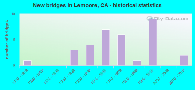
- New bridges - historical statistics
- 11910-1919
- 31940-1949
- 41950-1959
- 71960-1969
- 61970-1979
- 11980-1989
- 91990-1999
- 22010-2019
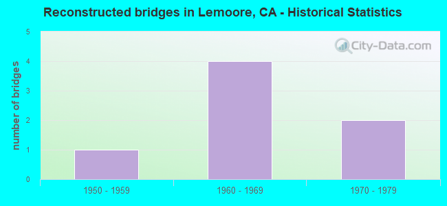
- Reconstructed bridges - Historical Statistics
- 11950-1959
- 41960-1969
- 21970-1979
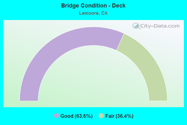
- Bridge Condition - Deck
- 63.6%Good
- 36.4%Fair
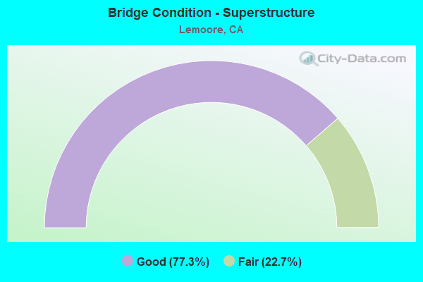
- Bridge Condition - Superstructure
- 77.3%Good
- 22.7%Fair
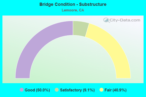
- Bridge Condition - Substructure
- 50.0%Good
- 9.1%Satisfactory
- 40.9%Fair
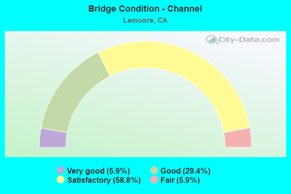
- Bridge Condition - Channel
- 5.9%Very good
- 29.4%Good
- 58.8%Satisfactory
- 5.9%Fair
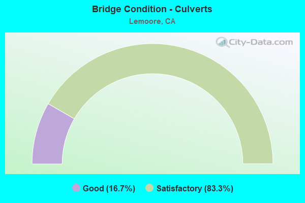
- Bridge Condition - Culverts
- 16.7%Good
- 83.3%Satisfactory
Find on map >> Show street view
Structure Number: 45 0016L, Location: 06-KIN-041-R45.54 (Lat: 36.362492, Lng: -119.809583), Route carried "on" structure: State highway 41, Year Built: 1976, Status: Open, Structure Length: 5.73m (18.80ft), Average Daily Traffic: 8,800 (year 2009), Truck Traffic: 14%, Average Future Daily Traffic: 12,451 (year 2040), Design Load: HS 20+Mod, Features Intersected: SOUTH FORK KINGS RIVER
Minimum Vertical Clearance: 30+ m (98+ ft), Kilometerpoint: 45.540, Lanes on structure: 2, Base Highway Network: Yes (, Subroute: 1), Owner: State Highway Agency, Approaching Roadway Width: 11.3m (37.1ft), Skew: 3 degrees, Material/Design: Concrete continuous, Design/Construction: Slab, Number Of Spans In Main Unit: 6, Length of Maximum Span: 10.4m (34.1ft), Curb-To-Curb Width: 11.6m (38.1ft), Out-to-Out Width: 12.7m (41.7ft)
Condition: Deck: Good, Superstructure: Good, Substructure: Satisfactory, Channel: Satisfactory, Operating Rating: 84.2 metric tons, Method Used To Determine Operating Rating: Load Factor (LF), Inventory Rating: 50.5 metric tons, Method Used To Determine Inventory Rating: Load Factor (LF), Structural Evaluation: Equal to present minimum criteria, Deck Geometry: Better than present minimum criteria, Waterway Adequacy: Better than present minimum criteria, Approach Roadway Alignment: Equal to present desirable criteria, Designated Inspection Frequency: Every 24 months, Inspection Date: December 2020, Deck Structure Type: Concrete Cast-file-Place, Wearing Surface/Protective System: Wearing Surface: Bituminous
Find on map >> Show street view
Structure Number: 45 0016R, Location: 06-KIN-041-R45.54 (Lat: 36.362719, Lng: -119.809300), Route carried "on" structure: State highway 41, Year Built: 1956, Year Reconstructed: 1976, Status: Open, Structure Length: 6.49m (21.29ft), Average Daily Traffic: 8,800 (year 2009), Truck Traffic: 14%, Average Future Daily Traffic: 12,451 (year 2040), Design Load: HS 20, Features Intersected: SOUTH FORK KINGS RIVER
Minimum Vertical Clearance: 30+ m (98+ ft), Kilometerpoint: 45.540, Lanes on structure: 2, Base Highway Network: Yes (, Subroute: 1), Owner: State Highway Agency, Approaching Roadway Width: 14.9m (48.9ft), Skew: 3 degrees, Material/Design: Concrete continuous, Design/Construction: Slab, Number Of Spans In Main Unit: 11, Length of Maximum Span: 6.1m (20.0ft), Curb-To-Curb Width: 14.9m (48.9ft), Out-to-Out Width: 15.9m (52.2ft)
Condition: Deck: Good, Superstructure: Good, Substructure: Good, Channel: Satisfactory, Operating Rating: 52.5 metric tons, Method Used To Determine Operating Rating: Load Factor (LF), Inventory Rating: 31.4 metric tons, Method Used To Determine Inventory Rating: Load Factor (LF), Structural Evaluation: Better than present minimum criteria, Deck Geometry: Superior to present desirable criteria, Waterway Adequacy: Equal to present desirable criteria, Approach Roadway Alignment: Equal to present desirable criteria, Designated Inspection Frequency: Every 24 months, Inspection Date: December 2020, Deck Structure Type: Concrete Cast-file-Place, Wearing Surface/Protective System: Wearing Surface: Bituminous
Find on map >> Show street view
Structure Number: 45 0058L, Location: 06-KIN-198-7.17 (Lat: 36.270436, Lng: -119.835158), Route carried "on" structure: State highway 198, Year Built: 1963, Year Reconstructed: 1973, Status: Open, Structure Length: 6.89m (22.60ft), Average Daily Traffic: 9,000 (year 2009), Truck Traffic: 8%, Average Future Daily Traffic: 19,782 (year 2038), Design Load: HS 20+Mod, Features Intersected: SJVR SPUR & 21ST AVE
Minimum Vertical Clearance: 30+ m (98+ ft), Kilometerpoint: 7.170, Lanes on structure: 2, Base Highway Network: Yes (Inventory Route: 1, Subroute: 1), Owner: State Highway Agency, Approaching Roadway Width: 10.4m (34.1ft), Skew: 2 degrees, Material/Design: Concrete continuous, Design/Construction: Tee Beam, Number Of Spans In Main Unit: 4, Length of Maximum Span: 20.7m (67.9ft), Curb-To-Curb Width: 11.4m (37.4ft), Out-to-Out Width: 12.3m (40.4ft)
Condition: Deck: Good, Superstructure: Good, Substructure: Satisfactory, Operating Rating: 34.7 metric tons, Method Used To Determine Operating Rating: Load and Resistance Factor Rating (LRFR) rating reported by rating factor(RF) method using HL-93 loadings, Inventory Rating: 24.6 metric tons, Method Used To Determine Inventory Rating: Load and Resistance Factor Rating (LRFR) rating reported by rating factor(RF) method using HL-93 loadings, Structural Evaluation: Equal to present minimum criteria, Deck Geometry: Equal to present minimum criteria, Approach Roadway Alignment: Equal to present desirable criteria, Designated Inspection Frequency: Every 24 months, Inspection Date: Febuary 2021, Deck Structure Type: Concrete Cast-file-Place, Wearing Surface/Protective System: Wearing Surface: Bituminous
Find on map >> Show street view
Structure Number: 45 0058R, Location: 06-KIN-198-7.17 (Lat: 36.270208, Lng: -119.835167), Route carried "on" structure: State highway 198, Year Built: 1963, Year Reconstructed: 1973, Status: Open, Structure Length: 6.89m (22.60ft), Average Daily Traffic: 9,000 (year 2009), Truck Traffic: 8%, Average Future Daily Traffic: 19,782 (year 2038), Design Load: HS 20+Mod, Features Intersected: SJVR SPUR & 21ST AVE
Minimum Vertical Clearance: 30+ m (98+ ft), Kilometerpoint: 7.170, Lanes on structure: 2, Base Highway Network: Yes (Inventory Route: 1, Subroute: 1), Owner: State Highway Agency, Approaching Roadway Width: 10.4m (34.1ft), Skew: 2 degrees, Material/Design: Concrete continuous, Design/Construction: Tee Beam, Number Of Spans In Main Unit: 4, Length of Maximum Span: 20.7m (67.9ft), Curb-To-Curb Width: 11.4m (37.4ft), Out-to-Out Width: 12.3m (40.4ft)
Condition: Deck: Good, Superstructure: Good, Substructure: Good, Operating Rating: 34.7 metric tons, Method Used To Determine Operating Rating: Load and Resistance Factor Rating (LRFR) rating reported by rating factor(RF) method using HL-93 loadings, Inventory Rating: 24.6 metric tons, Method Used To Determine Inventory Rating: Load and Resistance Factor Rating (LRFR) rating reported by rating factor(RF) method using HL-93 loadings, Structural Evaluation: Equal to present minimum criteria, Deck Geometry: Equal to present minimum criteria, Approach Roadway Alignment: Equal to present desirable criteria, Designated Inspection Frequency: Every 24 months, Inspection Date: Febuary 2021, Deck Structure Type: Concrete Cast-file-Place, Wearing Surface/Protective System: Wearing Surface: Bituminous
Find on map >> Show street view
Structure Number: 45 0076, Location: 06-KIN-198-R10.56 (Lat: 36.291844, Lng: -119.780933), Route carried "on" structure: County highway , Year Built: 1964, Status: Open, Structure Length: 5.79m (19.00ft), Average Daily Traffic: 8,765 (year 1997), Truck Traffic: 5%, Average Future Daily Traffic: 24,076 (year 2041), Design Load: HS 20, Features Intersected: STATE ROUTE 198, Facility Carried by Structure: 18TH AVENUE
Minimum Vertical Clearance: 30+ m (98+ ft), Kilometerpoint: 0.000, Lanes on structure: 2, Lanes under structure: 5, Base Highway Network: Yes, Owner: State Highway Agency, Approaching Roadway Width: 12.5m (41.0ft), Material/Design: Concrete continuous, Design/Construction: Box Beam or Girders - Multiple, Number Of Spans In Main Unit: 4, Length of Maximum Span: 24.7m (81.0ft), Curb or Sidewalk Widths: Left: 1.5m (4.9ft), Right: 1.5m (4.9ft), Curb-To-Curb Width: 12.4m (40.7ft), Out-to-Out Width: 16.4m (53.8ft)
Condition: Deck: Good, Superstructure: Good, Substructure: Good, Operating Rating: 30.5 metric tons, Method Used To Determine Operating Rating: Load and Resistance Factor Rating (LRFR) rating reported by rating factor(RF) method using HL-93 loadings, Inventory Rating: 23.7 metric tons, Method Used To Determine Inventory Rating: Load and Resistance Factor Rating (LRFR) rating reported by rating factor(RF) method using HL-93 loadings, Structural Evaluation: Somewhat better than minimum adequacy, Deck Geometry: Somewhat better than minimum adequacy, Underclear: Meets minimum limits, Approach Roadway Alignment: Equal to present minimum criteria, Length Of Structure Improvement: 5.79m (19.00ft), Designated Inspection Frequency: Every 24 months, Inspection Date: Febuary 2021, Bridge Improvement Cost: $950,000, Roadway Improvement Cost: $190,000, Total Project Cost: $1,596,000 ( Estimate for 2020), Deck Structure Type: Concrete Cast-file-Place
Find on map >> Show street view
Structure Number: 45 0077, Location: 06-KIN-198-R12.11 (Lat: 36.297658, Lng: -119.755461), Route carried "on" structure: County highway Z073, Year Built: 1964, Status: Open, Structure Length: 8.02m (26.31ft), Average Daily Traffic: 9,000 (year 1998), Truck Traffic: 3%, Average Future Daily Traffic: 10,977 (year 2041), Design Load: HS 20+Mod, Features Intersected: STATE ROUTE 198, Facility Carried by Structure: HOUSTON AVE
Minimum Vertical Clearance: 30+ m (98+ ft), Kilometerpoint: 0.000, Lanes on structure: 2, Lanes under structure: 5, Owner: State Highway Agency, Approaching Roadway Width: 12.5m (41.0ft), Skew: 4 degrees, Material/Design: Concrete continuous, Design/Construction: Box Beam or Girders - Multiple, Number Of Spans In Main Unit: 4, Length of Maximum Span: 31.4m (103.0ft), Curb or Sidewalk Widths: Left: 0.0m, Right: 1.5m (4.9ft), Curb-To-Curb Width: 12.4m (40.7ft), Out-to-Out Width: 14.8m (48.6ft)
Condition: Deck: Good, Superstructure: Good, Substructure: Fair, Operating Rating: 67.4 metric tons, Method Used To Determine Operating Rating: Load Factor (LF), Inventory Rating: 40.5 metric tons, Method Used To Determine Inventory Rating: Load Factor (LF), Structural Evaluation: Somewhat better than minimum adequacy, Deck Geometry: Somewhat better than minimum adequacy, Underclear: Somewhat better than minimum adequacy, Approach Roadway Alignment: Equal to present minimum criteria, Length Of Structure Improvement: 8.02m (26.31ft), Designated Inspection Frequency: Every 24 months, Inspection Date: Febuary 2021, Bridge Improvement Cost: $1,279,000, Roadway Improvement Cost: $255,000, Total Project Cost: $2,148,000 ( Estimate for 2020), Deck Structure Type: Concrete Cast-file-Place, Wearing Surface/Protective System: Wearing Surface: Integral Concrete
Find on map >> Show street view
Structure Number: 45 0082, Location: 06-KIN-198-R11.18 (Lat: 36.291650, Lng: -119.769969), Route carried "on" structure: State highway 198, Year Built: 1962, Status: Open, Structure Length: 1.13m (3.71ft), Average Daily Traffic: 21,300 (year 2009), Average Future Daily Traffic: 53,383 (year 2038), Features Intersected: LEMOORE CANAL
Minimum Vertical Clearance: 30+ m (98+ ft), Kilometerpoint: 11.180, Lanes on structure: 4, Base Highway Network: Yes (Inventory Route: 1, Subroute: 1), Owner: State Highway Agency, Approaching Roadway Width: 26.2m (86.0ft), Skew: 33 degrees, Material/Design: Concrete continuous, Design/Construction: Culvert, Number Of Spans In Main Unit: 3, Length of Maximum Span: 3.7m (12.1ft)
Condition: Channel: Very good, Culverts: Satisfactory, Operating Rating: 54.1 metric tons, Method Used To Determine Operating Rating: Field evaluation and documented engineering judgment, Inventory Rating: 32.4 metric tons, Method Used To Determine Inventory Rating: Field evaluation and documented engineering judgment, Structural Evaluation: Equal to present minimum criteria, Waterway Adequacy: Equal to present desirable criteria, Approach Roadway Alignment: Equal to present desirable criteria, Designated Inspection Frequency: Every 48 months, Inspection Date: Febuary 2021
Find on map >> Show street view
Structure Number: 45 0100L, Location: 06-KIN-041-R40.99 (Lat: 36.296272, Lng: -119.810575), Route carried "on" structure: State highway 41, Year Built: 1998, Status: Open, Structure Length: 4.05m (13.29ft), Average Daily Traffic: 4,550 (year 2009), Truck Traffic: 14%, Average Future Daily Traffic: 5,344 (year 2039), Design Load: HS 20+Mod, Features Intersected: BUSH STREET
Minimum Vertical Clearance: 30+ m (98+ ft), Kilometerpoint: 40.990, Lanes on structure: 2, Lanes under structure: 4, Base Highway Network: Yes (, Subroute: 1), Owner: State Highway Agency, Approaching Roadway Width: 12.9m (42.3ft), Material/Design: Prestressed concrete, Design/Construction: Box Beam or Girders - Multiple, Number Of Spans In Main Unit: 1, Length of Maximum Span: 40.5m (132.9ft), Curb-To-Curb Width: 12.9m (42.3ft), Out-to-Out Width: 13.9m (45.6ft)
Condition: Deck: Fair, Superstructure: Good, Substructure: Fair, Operating Rating: 54.1 metric tons, Method Used To Determine Operating Rating: Assigned rating based on Load Factor Design (LFD) reported in metric tons, Inventory Rating: 32.4 metric tons, Method Used To Determine Inventory Rating: Assigned rating based on Load Factor Design (LFD) reported in metric tons, Structural Evaluation: Somewhat better than minimum adequacy, Deck Geometry: Superior to present desirable criteria, Underclear: Better than present minimum criteria, Approach Roadway Alignment: Equal to present desirable criteria, Designated Inspection Frequency: Every 24 months, Inspection Date: December 2020, Deck Structure Type: Concrete Cast-file-Place
Find on map >> Show street view
Structure Number: 45 0100R, Location: 06-KIN-041-R40.99 (Lat: 36.296319, Lng: -119.810247), Route carried "on" structure: State highway 41, Year Built: 1998, Status: Open, Structure Length: 4.05m (13.29ft), Average Daily Traffic: 4,550 (year 2009), Truck Traffic: 14%, Average Future Daily Traffic: 5,344 (year 2039), Design Load: HS 20+Mod, Features Intersected: BUSH STREET
Minimum Vertical Clearance: 30+ m (98+ ft), Kilometerpoint: 40.990, Lanes on structure: 2, Lanes under structure: 4, Base Highway Network: Yes (, Subroute: 1), Owner: State Highway Agency, Approaching Roadway Width: 12.9m (42.3ft), Material/Design: Prestressed concrete, Design/Construction: Box Beam or Girders - Multiple, Number Of Spans In Main Unit: 1, Length of Maximum Span: 40.5m (132.9ft), Curb-To-Curb Width: 12.9m (42.3ft), Out-to-Out Width: 13.9m (45.6ft)
Condition: Deck: Good, Superstructure: Good, Substructure: Fair, Operating Rating: 54.1 metric tons, Method Used To Determine Operating Rating: Assigned rating based on Load Factor Design (LFD) reported in metric tons, Inventory Rating: 32.4 metric tons, Method Used To Determine Inventory Rating: Assigned rating based on Load Factor Design (LFD) reported in metric tons, Structural Evaluation: Somewhat better than minimum adequacy, Deck Geometry: Superior to present desirable criteria, Underclear: Better than present minimum criteria, Approach Roadway Alignment: Equal to present desirable criteria, Designated Inspection Frequency: Every 24 months, Inspection Date: December 2020, Deck Structure Type: Concrete Cast-file-Place
Find on map >> Show street view
Structure Number: 45 0101L, Location: 06-KIN-041-R41.16 (Lat: 36.299261, Lng: -119.810903), Route carried "on" structure: State highway 41, Year Built: 1999, Status: Open, Structure Length: 3.47m (11.38ft), Average Daily Traffic: 4,550 (year 2009), Truck Traffic: 14%, Average Future Daily Traffic: 13,303 (year 2039), Design Load: HS 20+Mod, Features Intersected: CIMARRON RR
Minimum Vertical Clearance: 30+ m (98+ ft), Kilometerpoint: 41.160, Lanes on structure: 3, Base Highway Network: Yes (, Subroute: 1), Owner: State Highway Agency, Approaching Roadway Width: 22.0m (72.2ft), Skew: 1 degrees, Material/Design: Prestressed concrete, Design/Construction: Box Beam or Girders - Multiple, Number Of Spans In Main Unit: 1, Length of Maximum Span: 34.7m (113.8ft), Curb-To-Curb Width: 19.6m (64.3ft), Out-to-Out Width: 20.6m (67.6ft)
Condition: Deck: Good, Superstructure: Good, Substructure: Fair, Operating Rating: 54.1 metric tons, Method Used To Determine Operating Rating: Assigned rating based on Load Factor Design (LFD) reported in metric tons, Inventory Rating: 32.4 metric tons, Method Used To Determine Inventory Rating: Assigned rating based on Load Factor Design (LFD) reported in metric tons, Structural Evaluation: Somewhat better than minimum adequacy, Deck Geometry: Superior to present desirable criteria, Underclear: Somewhat better than minimum adequacy, Approach Roadway Alignment: Equal to present desirable criteria, Designated Inspection Frequency: Every 24 months, Inspection Date: December 2020, Deck Structure Type: Concrete Cast-file-Place
Find on map >> Show street view
Structure Number: 45 0101R, Location: 06-KIN-041-R41.16 (Lat: 36.299322, Lng: -119.810514), Route carried "on" structure: State highway 41, Year Built: 1999, Status: Open, Structure Length: 3.47m (11.38ft), Average Daily Traffic: 4,550 (year 2009), Truck Traffic: 14%, Average Future Daily Traffic: 13,303 (year 2039), Design Load: HS 20+Mod, Features Intersected: CIMARRON RR
Minimum Vertical Clearance: 7.11m (23.33ft), Kilometerpoint: 41.160, Lanes on structure: 3, Base Highway Network: Yes (, Subroute: 1), Owner: State Highway Agency, Approaching Roadway Width: 16.0m (52.5ft), Skew: 1 degrees, Material/Design: Prestressed concrete, Design/Construction: Box Beam or Girders - Multiple, Number Of Spans In Main Unit: 1, Length of Maximum Span: 34.7m (113.8ft), Curb-To-Curb Width: 16.0m (52.5ft), Out-to-Out Width: 17.0m (55.8ft)
Condition: Deck: Good, Superstructure: Good, Substructure: Fair, Operating Rating: 54.1 metric tons, Method Used To Determine Operating Rating: Assigned rating based on Load Factor Design (LFD) reported in metric tons, Inventory Rating: 32.4 metric tons, Method Used To Determine Inventory Rating: Assigned rating based on Load Factor Design (LFD) reported in metric tons, Structural Evaluation: Somewhat better than minimum adequacy, Deck Geometry: Better than present minimum criteria, Underclear: Somewhat better than minimum adequacy, Approach Roadway Alignment: Equal to present desirable criteria, Designated Inspection Frequency: Every 24 months, Inspection Date: December 2020, Deck Structure Type: Concrete Cast-file-Place
Find on map >> Show street view
Structure Number: 45 0102L, Location: 06-KIN-041-R39.96 (Lat: 36.281864, Lng: -119.808186), Route carried "on" structure: State highway 41, Year Built: 1998, Status: Open, Structure Length: 6.22m (20.41ft), Average Daily Traffic: 5,850 (year 2009), Truck Traffic: 16%, Average Future Daily Traffic: 6,736 (year 2039), Design Load: HS 20+Mod, Features Intersected: STATE ROUTE 198
Minimum Vertical Clearance: 5.30m (17.39ft), Kilometerpoint: 39.960, Lanes on structure: 2, Lanes under structure: 4, Base Highway Network: Yes (, Subroute: 1), Owner: State Highway Agency, Approaching Roadway Width: 11.8m (38.7ft), Skew: 2 degrees, Material/Design: Prestressed concrete continuous, Design/Construction: Box Beam or Girders - Multiple, Number Of Spans In Main Unit: 3, Length of Maximum Span: 24.4m (80.1ft), Curb-To-Curb Width: 11.8m (38.7ft), Out-to-Out Width: 13.0m (42.7ft)
Condition: Deck: Fair, Superstructure: Good, Substructure: Fair, Operating Rating: 54.1 metric tons, Method Used To Determine Operating Rating: Assigned rating based on Load Factor Design (LFD) reported in metric tons, Inventory Rating: 32.4 metric tons, Method Used To Determine Inventory Rating: Assigned rating based on Load Factor Design (LFD) reported in metric tons, Structural Evaluation: Somewhat better than minimum adequacy, Deck Geometry: Better than present minimum criteria, Underclear: Meets minimum limits, Approach Roadway Alignment: Equal to present desirable criteria, Designated Inspection Frequency: Every 24 months, Inspection Date: December 2020, Deck Structure Type: Concrete Cast-file-Place
Find on map >> Show street view
Structure Number: 45 0102R, Location: 06-KIN-041-R39.96 (Lat: 36.282039, Lng: -119.807792), Route carried "on" structure: State highway 41, Year Built: 1998, Status: Open, Structure Length: 6.22m (20.41ft), Average Daily Traffic: 5,850 (year 2009), Truck Traffic: 16%, Average Future Daily Traffic: 6,736 (year 2039), Design Load: HS 20+Mod, Features Intersected: STATE ROUTE 198
Minimum Vertical Clearance: 5.53m (18.14ft), Kilometerpoint: 39.960, Lanes on structure: 3, Lanes under structure: 5, Base Highway Network: Yes (, Subroute: 1), Owner: State Highway Agency, Approaching Roadway Width: 18.0m (59.1ft), Skew: 2 degrees, Material/Design: Prestressed concrete continuous, Design/Construction: Box Beam or Girders - Multiple, Number Of Spans In Main Unit: 3, Length of Maximum Span: 24.5m (80.4ft), Curb-To-Curb Width: 17.9m (58.7ft), Out-to-Out Width: 19.0m (62.3ft)
Condition: Deck: Good, Superstructure: Good, Substructure: Good, Operating Rating: 54.1 metric tons, Method Used To Determine Operating Rating: Assigned rating based on Load Factor Design (LFD) reported in metric tons, Inventory Rating: 32.4 metric tons, Method Used To Determine Inventory Rating: Assigned rating based on Load Factor Design (LFD) reported in metric tons, Structural Evaluation: Better than present minimum criteria, Deck Geometry: Superior to present desirable criteria, Underclear: Meets minimum limits, Approach Roadway Alignment: Equal to present desirable criteria, Designated Inspection Frequency: Every 24 months, Inspection Date: December 2020, Deck Structure Type: Concrete Cast-file-Place
Find on map >> Show street view
Structure Number: 45 0104, Location: 06-KIN-198-R8.90 (Lat: 36.286106, Lng: -119.798933), Route carried "on" structure: County highway , Year Built: 2015, Status: Open, Structure Length: 9.54m (31.30ft), Average Daily Traffic: 18,000 (year 2015), Truck Traffic: 5%, Average Future Daily Traffic: 24,076 (year 2041), Design Load: HL 93, Features Intersected: STATE ROUTE 198, Facility Carried by Structure: 19TH AVENUE
Minimum Vertical Clearance: 30+ m (98+ ft), Kilometerpoint: 0.000, Lanes on structure: 5, Lanes under structure: 5, Base Highway Network: Yes, Owner: State Highway Agency, Approaching Roadway Width: 23.2m (76.1ft), Skew: 2 degrees, Material/Design: Prestressed concrete continuous, Design/Construction: Box Beam or Girders - Multiple, Number Of Spans In Main Unit: 2, Length of Maximum Span: 53.3m (174.9ft), Curb or Sidewalk Widths: Left: 1.5m (4.9ft), Right: 1.5m (4.9ft), Curb-To-Curb Width: 23.2m (76.1ft), Out-to-Out Width: 26.8m (87.9ft)
Condition: Deck: Fair, Superstructure: Good, Substructure: Good, Operating Rating: 42.1 metric tons, Method Used To Determine Operating Rating: Assigned ratings based on Load and Resistance Factor Design (LRFD) reported by rating factor (RF) using HL93 loadings, Inventory Rating: 32.4 metric tons, Method Used To Determine Inventory Rating: Assigned ratings based on Load and Resistance Factor Design (LRFD) reported by rating factor (RF) using HL93 loadings, Structural Evaluation: Better than present minimum criteria, Deck Geometry: Better than present minimum criteria, Underclear: Equal to present minimum criteria, Approach Roadway Alignment: Equal to present desirable criteria, Designated Inspection Frequency: Every 24 months, Inspection Date: Febuary 2021, Deck Structure Type: Concrete Cast-file-Place
Find on map >> Show street view
Structure Number: 45C0015, Location: 0.2 MI N/0 GRANGEVILLE BL (Lat: 36.347950, Lng: -119.851264), Route carried "on" structure: County highway , Year Built: 1954, Status: Open, Structure Length: 5.80m (19.03ft), Average Daily Traffic: 1,257 (year 2018), Truck Traffic: 15%, Average Future Daily Traffic: 1,567 (year 2042), Design Load: H 20, Features Intersected: CLARKS FORK KINGS RIVER, Facility Carried by Structure: 22ND AVE
Minimum Vertical Clearance: 30+ m (98+ ft), Kilometerpoint: 0.000, Lanes on structure: 2, Base Highway Network: Yes, Owner: County Highway Agency, Approaching Roadway Width: 7.9m (25.9ft), Skew: 4 degrees, Material/Design: Concrete continuous, Design/Construction: Slab, Number Of Spans In Main Unit: 9, Length of Maximum Span: 6.7m (22.0ft), Curb or Sidewalk Widths: Left: 0.3m (1.0ft), Right: 0.3m (1.0ft), Curb-To-Curb Width: 7.9m (25.9ft), Out-to-Out Width: 8.7m (28.5ft)
Condition: Deck: Good, Superstructure: Good, Substructure: Good, Channel: Good, Operating Rating: 50.9 metric tons, Method Used To Determine Operating Rating: Load Factor (LF), Inventory Rating: 30.5 metric tons, Method Used To Determine Inventory Rating: Load Factor (LF), Structural Evaluation: Better than present minimum criteria, Deck Geometry: Meets minimum limits, Waterway Adequacy: Better than present minimum criteria, Approach Roadway Alignment: Equal to present desirable criteria, Designated Inspection Frequency: Every 24 months, Inspection Date: September 2020, Deck Structure Type: Concrete Cast-file-Place, Wearing Surface/Protective System: Wearing Surface: Bituminous
Find on map >> Show street view
Structure Number: 45C002, Location: 0.6 MI W OF 16TH AVE (Lat: 36.342514, Lng: -119.755622), Route carried "on" structure: County highway , Year Built: 1996, Status: Open, Structure Length: 3.41m (11.19ft), Average Daily Traffic: 5,372 (year 2018), Truck Traffic: 15%, Average Future Daily Traffic: 3,717 (year 2042), Design Load: HS 20+Mod, Features Intersected: LEMOORE CANAL, Facility Carried by Structure: GRANGEVILLE BLVD
Minimum Vertical Clearance: 30+ m (98+ ft), Kilometerpoint: 0.000, Lanes on structure: 2, Owner: County Highway Agency, Approaching Roadway Width: 8.5m (27.9ft), Skew: 6 degrees, Material/Design: Concrete continuous, Design/Construction: Slab, Number Of Spans In Main Unit: 3, Length of Maximum Span: 11.6m (38.1ft), Curb-To-Curb Width: 12.3m (40.4ft), Out-to-Out Width: 13.3m (43.6ft)
Condition: Deck: Good, Superstructure: Good, Substructure: Good, Channel: Good, Operating Rating: 54.1 metric tons, Method Used To Determine Operating Rating: Assigned rating based on Load Factor Design (LFD) reported in metric tons, Inventory Rating: 32.4 metric tons, Method Used To Determine Inventory Rating: Assigned rating based on Load Factor Design (LFD) reported in metric tons, Structural Evaluation: Better than present minimum criteria, Deck Geometry: Somewhat better than minimum adequacy, Waterway Adequacy: Meets minimum limits, Approach Roadway Alignment: Equal to present desirable criteria, Designated Inspection Frequency: Every 24 months, Inspection Date: October 2020, Deck Structure Type: Concrete Cast-file-Place, Wearing Surface/Protective System: Wearing Surface: Bituminous
Find on map >> Show street view
Structure Number: 45C0025, Location: 0.6 MI W OF 22ND AVE (Lat: 36.343911, Lng: -119.862681), Route carried "on" structure: County highway , Year Built: 1959, Status: Open, Structure Length: 6.07m (19.91ft), Average Daily Traffic: 3,610 (year 2018), Truck Traffic: 15%, Average Future Daily Traffic: 3,263 (year 2042), Design Load: H 20, Features Intersected: KINGS RIVER, Facility Carried by Structure: GRANGEVILLE BL
Minimum Vertical Clearance: 30+ m (98+ ft), Kilometerpoint: 0.000, Lanes on structure: 2, Base Highway Network: Yes, Owner: County Highway Agency, Approaching Roadway Width: 9.7m (31.8ft), Skew: 4 degrees, Material/Design: Concrete continuous, Design/Construction: Slab, Number Of Spans In Main Unit: 8, Length of Maximum Span: 7.9m (25.9ft), Curb-To-Curb Width: 9.7m (31.8ft), Out-to-Out Width: 9.9m (32.5ft)
Condition: Deck: Good, Superstructure: Good, Substructure: Fair, Channel: Satisfactory, Operating Rating: 54.1 metric tons, Method Used To Determine Operating Rating: Load Factor (LF), Inventory Rating: 32.4 metric tons, Method Used To Determine Inventory Rating: Load Factor (LF), Structural Evaluation: Somewhat better than minimum adequacy, Deck Geometry: Meets minimum limits, Waterway Adequacy: Better than present minimum criteria, Approach Roadway Alignment: Equal to present desirable criteria, Designated Inspection Frequency: Every 24 months, Inspection Date: September 2020, Deck Structure Type: Concrete Cast-file-Place, Wearing Surface/Protective System: Wearing Surface: Bituminous
Find on map >> Show street view
Structure Number: 45C0031, Location: 0.1 MI W 17TH AVE (Lat: 36.313436, Lng: -119.764625), Route carried "on" structure: County highway , Year Built: 1917, Year Reconstructed: 1958, Status: Open, Structure Length: 1.55m (5.09ft), Average Daily Traffic: 8,915 (year 2018), Truck Traffic: 10%, Average Future Daily Traffic: 9,584 (year 2042), Features Intersected: LEMOORE CANAL, Facility Carried by Structure: HANFORD-ARMONA RD
Minimum Vertical Clearance: 30+ m (98+ ft), Kilometerpoint: 0.000, Lanes on structure: 2, Base Highway Network: Yes, Owner: County Highway Agency, Approaching Roadway Width: 8.5m (27.9ft), Skew: 1 degrees, Material/Design: Concrete continuous, Design/Construction: Slab, Number Of Spans In Main Unit: 3, Length of Maximum Span: 4.9m (16.1ft), Curb-To-Curb Width: 12.1m (39.7ft), Out-to-Out Width: 12.3m (40.4ft)
Condition: Deck: Good, Superstructure: Good, Substructure: Good, Channel: Satisfactory, Operating Rating: 26.9 metric tons, Method Used To Determine Operating Rating: Field evaluation and documented engineering judgment, Inventory Rating: 16.2 metric tons, Method Used To Determine Inventory Rating: Field evaluation and documented engineering judgment, Structural Evaluation: Meets minimum limits, Deck Geometry: Somewhat better than minimum adequacy, Waterway Adequacy: Somewhat better than minimum adequacy, Approach Roadway Alignment: Equal to present desirable criteria, Designated Inspection Frequency: Every 24 months, Inspection Date: October 2020, Deck Structure Type: Concrete Cast-file-Place, Wearing Surface/Protective System: Wearing Surface: Bituminous
Find on map >> Show street view
Structure Number: 45C0041, Location: 0.3 MI W OF 19TH AVE (Lat: 36.367633, Lng: -119.802964), Route carried "on" structure: County highway , Year Built: 1976, Status: Open, Structure Length: 7.80m (25.59ft), Average Daily Traffic: 600 (year 2018), Truck Traffic: 10%, Average Future Daily Traffic: 645 (year 2042), Design Load: HS 20, Features Intersected: SOUTH FORK KINGS RIVER, Facility Carried by Structure: FREMONT AVE
Minimum Vertical Clearance: 30+ m (98+ ft), Kilometerpoint: 0.000, Lanes on structure: 2, Owner: County Highway Agency, Approaching Roadway Width: 8.4m (27.6ft), Skew: 4 degrees, Material/Design: Concrete continuous, Design/Construction: Slab, Number Of Spans In Main Unit: 8, Length of Maximum Span: 10.4m (34.1ft), Curb-To-Curb Width: 9.7m (31.8ft), Out-to-Out Width: 9.9m (32.5ft)
Condition: Deck: Fair, Superstructure: Fair, Substructure: Good, Channel: Good, Operating Rating: 51.8 metric tons, Method Used To Determine Operating Rating: Load and Resistance Factor Rating (LRFR) rating reported by rating factor(RF) method using HL-93 loadings, Inventory Rating: 36.9 metric tons, Method Used To Determine Inventory Rating: Load and Resistance Factor Rating (LRFR) rating reported by rating factor(RF) method using HL-93 loadings, Structural Evaluation: Somewhat better than minimum adequacy, Deck Geometry: Equal to present minimum criteria, Waterway Adequacy: Better than present minimum criteria, Approach Roadway Alignment: Equal to present desirable criteria, Designated Inspection Frequency: Every 24 months, Inspection Date: September 2020, Deck Structure Type: Concrete Cast-file-Place
Find on map >> Show street view
Structure Number: 45C0044, Location: @ 17TH AVE (Lat: 36.328003, Lng: -119.763114), Route carried "on" structure: County highway , Year Built: 1983, Status: Open, Structure Length: 2.03m (6.66ft), Average Daily Traffic: 3,748 (year 2018), Truck Traffic: 15%, Average Future Daily Traffic: 1,567 (year 2042), Design Load: HS 20, Features Intersected: LEMOORE CANAL, Facility Carried by Structure: LACEY BLVD
Minimum Vertical Clearance: 30+ m (98+ ft), Kilometerpoint: 0.000, Lanes on structure: 2, Owner: County Highway Agency, Approaching Roadway Width: 8.0m (26.2ft), Skew: 1 degrees, Material/Design: Concrete continuous, Design/Construction: Slab, Number Of Spans In Main Unit: 2, Length of Maximum Span: 10.1m (33.1ft), Curb-To-Curb Width: 9.8m (32.2ft), Out-to-Out Width: 9.9m (32.5ft)
Condition: Deck: Fair, Superstructure: Fair, Substructure: Good, Channel: Good, Operating Rating: 39.2 metric tons, Method Used To Determine Operating Rating: Load and Resistance Factor Rating (LRFR) rating reported by rating factor(RF) method using HL-93 loadings, Inventory Rating: 30.5 metric tons, Method Used To Determine Inventory Rating: Load and Resistance Factor Rating (LRFR) rating reported by rating factor(RF) method using HL-93 loadings, Structural Evaluation: Somewhat better than minimum adequacy, Deck Geometry: Meets minimum limits, Waterway Adequacy: Equal to present desirable criteria, Approach Roadway Alignment: Equal to present desirable criteria, Designated Inspection Frequency: Every 24 months, Inspection Date: September 2020, Deck Structure Type: Concrete Cast-file-Place
Find on map >> Show street view
Structure Number: 45C0065, Location: 0.4 MI N IDAHO AVE (Lat: 36.273931, Lng: -119.780847), Route carried "on" structure: County highway , Year Built: 1940, Year Reconstructed: 1972, Status: Open, Structure Length: 0.97m (3.18ft), Average Daily Traffic: 2,500 (year 2018), Truck Traffic: 10%, Average Future Daily Traffic: 2,866 (year 2042), Features Intersected: W BR LEMOORE CANAL, Facility Carried by Structure: 18TH AVE
Minimum Vertical Clearance: 30+ m (98+ ft), Kilometerpoint: 0.000, Lanes on structure: 2, Owner: County Highway Agency, Approaching Roadway Width: 9.8m (32.2ft), Skew: 3 degrees, Material/Design: Concrete continuous, Design/Construction: Culvert, Number Of Spans In Main Unit: 3, Length of Maximum Span: 3.1m (10.2ft), Curb-To-Curb Width: 11.5m (37.7ft), Out-to-Out Width: 12.1m (39.7ft)
Condition: Channel: Satisfactory, Culverts: Satisfactory, Operating Rating: 27.2 metric tons, Method Used To Determine Operating Rating: Field evaluation and documented engineering judgment, Inventory Rating: 16.2 metric tons, Method Used To Determine Inventory Rating: Field evaluation and documented engineering judgment, Structural Evaluation: Meets minimum limits, Deck Geometry: Somewhat better than minimum adequacy, Waterway Adequacy: Somewhat better than minimum adequacy, Approach Roadway Alignment: Equal to present desirable criteria, Designated Inspection Frequency: Every 24 months, Inspection Date: October 2020
Find on map >> Show street view
Structure Number: 45C0066, Location: E LEMOORE (Lat: 36.299083, Lng: -119.767300), Route carried "on" structure: County highway , Year Built: 1950, Status: Open, Structure Length: 1.04m (3.41ft), Average Daily Traffic: 2,344 (year 2018), Truck Traffic: 15%, Average Future Daily Traffic: 4,247 (year 2042), Features Intersected: LEMOORE CANAL, Facility Carried by Structure: D ST
Minimum Vertical Clearance: 30+ m (98+ ft), Kilometerpoint: 0.000, Lanes on structure: 2, Owner: County Highway Agency, Approaching Roadway Width: 9.1m (29.9ft), Skew: 2 degrees, Material/Design: Concrete continuous, Design/Construction: Culvert, Number Of Spans In Main Unit: 3, Length of Maximum Span: 3.4m (11.2ft)
Condition: Channel: Satisfactory, Culverts: Satisfactory, Operating Rating: 40.5 metric tons, Method Used To Determine Operating Rating: Field evaluation and documented engineering judgment, Inventory Rating: 24.3 metric tons, Method Used To Determine Inventory Rating: Field evaluation and documented engineering judgment, Structural Evaluation: Equal to present minimum criteria, Waterway Adequacy: Somewhat better than minimum adequacy, Approach Roadway Alignment: Equal to present desirable criteria, Designated Inspection Frequency: Every 24 months, Inspection Date: October 2020
Find on map >> Show street view
Structure Number: 45C0068, Location: N/O JACKSON AVE (Lat: 36.255314, Lng: -119.780761), Route carried "on" structure: County highway , Year Built: 1940, Year Reconstructed: 1972, Status: Open, Structure Length: 0.69m (2.26ft), Average Daily Traffic: 6,960 (year 2018), Truck Traffic: 15%, Average Future Daily Traffic: 7,654 (year 2042), Features Intersected: LEMOORE CANAL, Facility Carried by Structure: 18TH AVE
Minimum Vertical Clearance: 30+ m (98+ ft), Kilometerpoint: 0.000, Lanes on structure: 2, Owner: County Highway Agency, Approaching Roadway Width: 9.8m (32.2ft), Skew: 9 degrees, Material/Design: Concrete continuous, Design/Construction: Culvert, Number Of Spans In Main Unit: 2, Length of Maximum Span: 3.2m (10.5ft)
Condition: Channel: Satisfactory, Culverts: Satisfactory, Operating Rating: 27.2 metric tons, Method Used To Determine Operating Rating: Field evaluation and documented engineering judgment, Inventory Rating: 16.2 metric tons, Method Used To Determine Inventory Rating: Field evaluation and documented engineering judgment, Structural Evaluation: Meets minimum limits, Waterway Adequacy: Somewhat better than minimum adequacy, Approach Roadway Alignment: Equal to present desirable criteria, Designated Inspection Frequency: Every 24 months, Inspection Date: October 2020
Find on map >> Show street view
Structure Number: 45C0069, Location: 0.1 MI SO JERSEY AVE (Lat: 36.239328, Lng: -119.780575), Route carried "on" structure: County highway , Year Built: 1972, Status: Open, Structure Length: 1.04m (3.41ft), Average Daily Traffic: 1,500 (year 2018), Truck Traffic: 10%, Average Future Daily Traffic: 2,088 (year 2042), Features Intersected: E BR LEMOORE CANAL, Facility Carried by Structure: 18TH AVE
Minimum Vertical Clearance: 30+ m (98+ ft), Kilometerpoint: 0.000, Lanes on structure: 2, Owner: County Highway Agency, Approaching Roadway Width: 23.4m (76.8ft), Skew: 4 degrees, Material/Design: Concrete continuous, Design/Construction: Culvert, Number Of Spans In Main Unit: 3, Length of Maximum Span: 3.3m (10.8ft)
Condition: Channel: Satisfactory, Culverts: Good, Operating Rating: 40.5 metric tons, Method Used To Determine Operating Rating: Field evaluation and documented engineering judgment, Inventory Rating: 24.3 metric tons, Method Used To Determine Inventory Rating: Field evaluation and documented engineering judgment, Structural Evaluation: Equal to present minimum criteria, Waterway Adequacy: Somewhat better than minimum adequacy, Approach Roadway Alignment: Equal to present desirable criteria, Designated Inspection Frequency: Every 24 months, Inspection Date: October 2020
Find on map >> Show street view
Structure Number: 45C0095, Location: S/O FAIRFAX AVE (Lat: 36.350956, Lng: -119.833933), Route carried "on" structure: County highway , Year Built: 1976, Status: Open, Structure Length: 5.91m (19.39ft), Average Daily Traffic: 500 (year 2018), Truck Traffic: 10%, Average Future Daily Traffic: 529 (year 2042), Design Load: HS 20, Features Intersected: KINGS RIVER (CLARKS FK), Facility Carried by Structure: 21ST AVE
Minimum Vertical Clearance: 30+ m (98+ ft), Kilometerpoint: 0.000, Lanes on structure: 2, Owner: County Highway Agency, Approaching Roadway Width: 9.9m (32.5ft), Material/Design: Concrete continuous, Design/Construction: Slab, Number Of Spans In Main Unit: 7, Number Of Approach Spans: 2, Length of Maximum Span: 8.5m (27.9ft), Curb-To-Curb Width: 9.9m (32.5ft), Out-to-Out Width: 9.9m (32.5ft)
Condition: Deck: Fair, Superstructure: Fair, Substructure: Fair, Channel: Satisfactory, Operating Rating: 59.0 metric tons, Method Used To Determine Operating Rating: Load Factor (LF), Inventory Rating: 35.3 metric tons, Method Used To Determine Inventory Rating: Load Factor (LF), Structural Evaluation: Somewhat better than minimum adequacy, Deck Geometry: Equal to present minimum criteria, Waterway Adequacy: Better than present minimum criteria, Approach Roadway Alignment: Equal to present desirable criteria, Designated Inspection Frequency: Every 24 months, Inspection Date: September 2020, Deck Structure Type: Concrete Cast-file-Place
Find on map >> Show street view
Structure Number: 45C0097, Location: 0.2 MI E 17TH AVE (Lat: 36.338897, Lng: -119.759961), Route carried "on" structure: County highway , Year Built: 1978, Status: Open, Structure Length: 1.78m (5.84ft), Average Daily Traffic: 100 (year 2018), Truck Traffic: 15%, Average Future Daily Traffic: 105 (year 2042), Features Intersected: LEMOORE CANAL, Facility Carried by Structure: COLONY RD
Minimum Vertical Clearance: 30+ m (98+ ft), Kilometerpoint: 0.000, Lanes on structure: 2, Owner: County Highway Agency, Approaching Roadway Width: 6.1m (20.0ft), Material/Design: Concrete continuous, Design/Construction: Slab, Number Of Spans In Main Unit: 2, Length of Maximum Span: 8.8m (28.9ft), Curb-To-Curb Width: 8.5m (27.9ft), Out-to-Out Width: 8.7m (28.5ft)
Condition: Deck: Fair, Superstructure: Fair, Substructure: Good, Channel: Satisfactory, Operating Rating: 54.1 metric tons, Method Used To Determine Operating Rating: Field evaluation and documented engineering judgment, Inventory Rating: 32.4 metric tons, Method Used To Determine Inventory Rating: Field evaluation and documented engineering judgment, Structural Evaluation: Somewhat better than minimum adequacy, Deck Geometry: Better than present minimum criteria, Waterway Adequacy: Equal to present desirable criteria, Approach Roadway Alignment: Equal to present desirable criteria, Designated Inspection Frequency: Every 24 months, Inspection Date: September 2020, Deck Structure Type: Concrete Cast-file-Place
Find on map >> Show street view
Structure Number: 45C0113, Location: 0.3 MI W OF 23RD AVE (Lat: 36.328497, Lng: -119.875778), Route carried "on" structure: County highway , Year Built: 1974, Status: Open, Structure Length: 5.91m (19.39ft), Average Daily Traffic: 400 (year 2018), Truck Traffic: 15%, Average Future Daily Traffic: 366 (year 2042), Design Load: HS 20, Features Intersected: KINGS RIVER CLARKS FORK, Facility Carried by Structure: LACEY BLVD
Minimum Vertical Clearance: 30+ m (98+ ft), Kilometerpoint: 0.000, Lanes on structure: 2, Owner: County Highway Agency, Approaching Roadway Width: 6.5m (21.3ft), Skew: 2 degrees, Material/Design: Concrete continuous, Design/Construction: Slab, Number Of Spans In Main Unit: 7, Length of Maximum Span: 8.5m (27.9ft), Curb-To-Curb Width: 9.7m (31.8ft), Out-to-Out Width: 9.9m (32.5ft)
Condition: Deck: Fair, Superstructure: Fair, Substructure: Fair, Channel: Good, Operating Rating: 31.8 metric tons, Method Used To Determine Operating Rating: Load Factor (LF), Inventory Rating: 19.1 metric tons, Method Used To Determine Inventory Rating: Load Factor (LF), Structural Evaluation: Somewhat better than minimum adequacy, Deck Geometry: Equal to present minimum criteria, Waterway Adequacy: Equal to present desirable criteria, Approach Roadway Alignment: Equal to present minimum criteria, Designated Inspection Frequency: Every 24 months, Inspection Date: September 2020, Deck Structure Type: Concrete Cast-file-Place
Find on map >> Show street view
Structure Number: 45C0137, Location: 0.5 MI E 18TH AVE (Lat: 36.269117, Lng: -119.771542), Route carried "on" structure: County highway , Year Built: 1940, Year Reconstructed: 1970, Status: Open, Structure Length: 0.98m (3.22ft), Average Daily Traffic: 641 (year 2018), Truck Traffic: 10%, Average Future Daily Traffic: 756 (year 2042), Features Intersected: LEMOORE CANAL, Facility Carried by Structure: IDAHO AVE
Minimum Vertical Clearance: 30+ m (98+ ft), Kilometerpoint: 0.000, Lanes on structure: 2, Owner: County Highway Agency, Approaching Roadway Width: 6.4m (21.0ft), Skew: 3 degrees, Material/Design: Concrete continuous, Design/Construction: Culvert, Number Of Spans In Main Unit: 3, Length of Maximum Span: 3.0m (9.8ft)
Condition: Channel: Fair, Culverts: Satisfactory, Operating Rating: 27.2 metric tons, Method Used To Determine Operating Rating: Field evaluation and documented engineering judgment, Inventory Rating: 16.2 metric tons, Method Used To Determine Inventory Rating: Field evaluation and documented engineering judgment, Structural Evaluation: Meets minimum limits, Waterway Adequacy: Somewhat better than minimum adequacy, Approach Roadway Alignment: Equal to present desirable criteria, Designated Inspection Frequency: Every 24 months, Inspection Date: October 2020
Find on map >> Show street view
Structure Number: 45 0076, Location: 06-KIN-198-R10.56 (Lat: 36.291844, Lng: -119.780933), Route carried "under" structure: State highway 198, Year Built: 1964, Structure Length: 0. m, Average Daily Traffic: 21,300 (year 2009), Features Intersected: STATE ROUTE 198, Facility Carried by Structure: 18TH AVENUE
Minimum Vertical Clearance: 4.69m (15.39ft), Kilometerpoint: 10.560, Lanes on structure: 2, Lanes under structure: 5, Material/Design: Concrete continuous, Design/Construction: Box Beam or Girders - Multiple, Length of Maximum Span: 24.7m (81.0ft)
Find on map >> Show street view
Structure Number: 45 0077, Location: 06-KIN-198-R12.11 (Lat: 36.297658, Lng: -119.755461), Route carried "under" structure: State highway 198, Year Built: 1964, Structure Length: 0. m, Average Daily Traffic: 27,500 (year 2009), Truck Traffic: 8%, Features Intersected: STATE ROUTE 198, Facility Carried by Structure: HOUSTON AVE
Minimum Vertical Clearance: 4.52m (14.83ft), Kilometerpoint: 12.110, Lanes on structure: 2, Lanes under structure: 5, Material/Design: Concrete continuous, Design/Construction: Box Beam or Girders - Multiple, Length of Maximum Span: 31.4m (103.0ft)
Find on map >> Show street view
Structure Number: 45 0102L, Location: 06-KIN-041-R39.96 (Lat: 36.281864, Lng: -119.808186), Route carried "under" structure: State highway 198, Year Built: 1998, Structure Length: 0. m, Average Daily Traffic: 20,100 (year 2009), Truck Traffic: 8%, Features Intersected: STATE ROUTE 198, Facility Carried by Structure: STATE ROUTE 41 SB
Minimum Vertical Clearance: 5.30m (17.39ft), Kilometerpoint: 8.900, Lanes on structure: 2, Lanes under structure: 4, Material/Design: Prestressed concrete continuous, Design/Construction: Box Beam or Girders - Multiple, Length of Maximum Span: 24.4m (80.1ft)
Find on map >> Show street view
Structure Number: 45 0102R, Location: 06-KIN-041-R39.96 (Lat: 36.282039, Lng: -119.807792), Route carried "under" structure: State highway 198, Year Built: 1998, Structure Length: 0. m, Average Daily Traffic: 20,100 (year 2009), Truck Traffic: 8%, Features Intersected: STATE ROUTE 198, Facility Carried by Structure: STATE ROUTE 41 NB
Minimum Vertical Clearance: 5.48m (17.98ft), Kilometerpoint: 8.900, Lanes on structure: 3, Lanes under structure: 5, Material/Design: Prestressed concrete continuous, Design/Construction: Box Beam or Girders - Multiple, Length of Maximum Span: 24.5m (80.4ft)
Find on map >> Show street view
Structure Number: 45 0104, Location: 06-KIN-198-R8.90 (Lat: 36.286106, Lng: -119.798933), Route carried "under" structure: State highway 198, Year Built: 2015, Structure Length: 0. m, Average Daily Traffic: 19,250 (year 2009), Truck Traffic: 8%, Features Intersected: STATE ROUTE 198, Facility Carried by Structure: 19TH AVENUE
Minimum Vertical Clearance: 5.43m (17.81ft), Kilometerpoint: 8.900, Lanes on structure: 5, Lanes under structure: 5, Material/Design: Prestressed concrete continuous, Design/Construction: Box Beam or Girders - Multiple, Length of Maximum Span: 53.3m (174.9ft)