Bridge Statistics for Lenhartsville, Pennsylvania (PA)
Condition, Traffic, Stress, Structural Evaluation, Project Costs
- National Bridge Inventory (NBI) Statistics
- 17Number of bridges
- 177ft / 53.6mTotal length
- $1,792,000Total costs
- 269,317Total average daily traffic
- 87,956Total average daily truck traffic
- National Bridge Inventory (NBI) Registered Bridges for Lenhartsville
- No street view available for this location
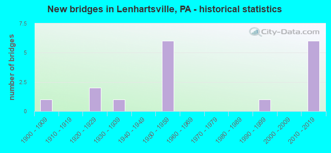
- New bridges - historical statistics
- 11900-1909
- 21920-1929
- 11930-1939
- 61950-1959
- 11990-1999
- 62010-2019
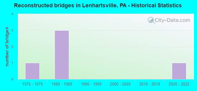
- Reconstructed bridges - Historical Statistics
- 11970-1979
- 31980-1989
- 01990-1999
- 02000-2009
- 02010-2019
- 12020-2022
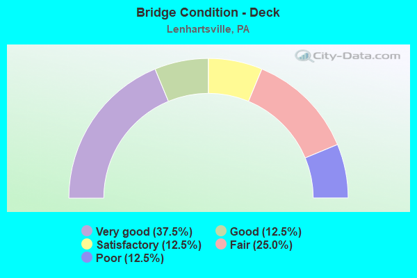
- Bridge Condition - Deck
- 37.5%Very good
- 12.5%Good
- 12.5%Satisfactory
- 25.0%Fair
- 12.5%Poor
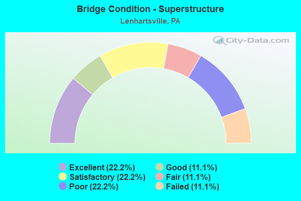
- Bridge Condition - Superstructure
- 22.2%Excellent
- 11.1%Good
- 22.2%Satisfactory
- 11.1%Fair
- 22.2%Poor
- 11.1%Failed
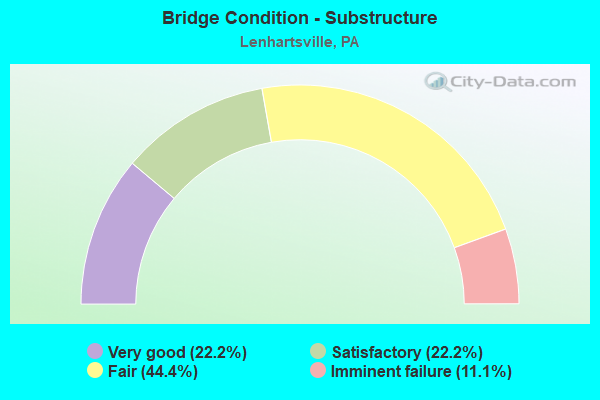
- Bridge Condition - Substructure
- 22.2%Very good
- 22.2%Satisfactory
- 44.4%Fair
- 11.1%Imminent failure
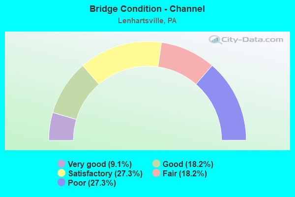
- Bridge Condition - Channel
- 9.1%Very good
- 18.2%Good
- 27.3%Satisfactory
- 18.2%Fair
- 27.3%Poor
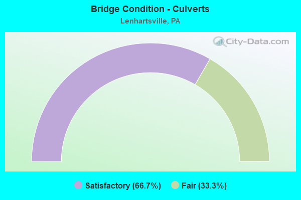
- Bridge Condition - Culverts
- 66.7%Satisfactory
- 33.3%Fair
Find on map >> Show street view
Structure Number: 4675, Location: 1 MI.W.OF LENHARTSVILLE (Lat: 40.577292, Lng: -75.906275), Route carried "on" structure: Interstate 78, Year Built: 1957, Year Reconstructed: 1985, Status: Open, Structure Length: 0.73m (2.40ft), Average Daily Traffic: 40,738 (year 2021), Truck Traffic: 38%, Average Future Daily Traffic: 50,359 (year 2032), Design Load: HS 20+Mod, Features Intersected: TRIB.TO FURNACE CKEEK
Minimum Vertical Clearance: 30+ m (98+ ft), Kilometerpoint: 42.110, Lanes on structure: 4, Base Highway Network: Yes, Owner: State Highway Agency, Approaching Roadway Width: 25.6m (84.0ft), Skew: 34 degrees, Material/Design: Concrete, Design/Construction: Culvert, Number Of Spans In Main Unit: 1, Length of Maximum Span: 7.3m (24.0ft)
Condition: Channel: Satisfactory, Culverts: Satisfactory, Operating Rating: 69.9 metric tons, Method Used To Determine Operating Rating: Load Factor (LF), Inventory Rating: 41.7 metric tons, Method Used To Determine Inventory Rating: Load Factor (LF), Structural Evaluation: Equal to present minimum criteria, Waterway Adequacy: Superior to present desirable criteria, Approach Roadway Alignment: Equal to present desirable criteria, Length Of Structure Improvement: 1.40m (4.59ft), Designated Inspection Frequency: Every 48 months, Inspection Date: May 2021
Find on map >> Show street view
Structure Number: 4676, Location: .75 M.W. LENHARTSVILLE (Lat: 40.578150, Lng: -75.901419), Route carried "on" structure: Interstate 78, Year Built: 1957, Year Reconstructed: 1985, Status: Open, Structure Length: 0.70m (2.30ft), Average Daily Traffic: 40,738 (year 2021), Truck Traffic: 38%, Average Future Daily Traffic: 50,359 (year 2032), Design Load: HS 20+Mod, Features Intersected: FURNACE CREEK
Minimum Vertical Clearance: 30+ m (98+ ft), Kilometerpoint: 42.110, Lanes on structure: 4, Base Highway Network: Yes, Owner: State Highway Agency, Approaching Roadway Width: 25.6m (84.0ft), Skew: 34 degrees, Material/Design: Concrete, Design/Construction: Culvert, Number Of Spans In Main Unit: 1, Length of Maximum Span: 7.0m (23.0ft)
Condition: Channel: Good, Culverts: Fair, Operating Rating: 67.1 metric tons, Method Used To Determine Operating Rating: Load Factor (LF), Inventory Rating: 39.9 metric tons, Method Used To Determine Inventory Rating: Load Factor (LF), Structural Evaluation: Somewhat better than minimum adequacy, Waterway Adequacy: Superior to present desirable criteria, Approach Roadway Alignment: Equal to present desirable criteria, Length Of Structure Improvement: 1.30m (4.27ft), Designated Inspection Frequency: Every 24 months, Inspection Date: May 2021
Find on map >> Show street view
Structure Number: 4677, Location: LENHARTSVILLE INTERCHANGE (Lat: 40.576519, Lng: -75.887894), Route carried "on" structure: Spur Interstate 78, Year Built: 1955, Year Reconstructed: 1985, Status: Open, Structure Length: 20.33m (66.70ft), Average Daily Traffic: 45,122 (year 2022), Truck Traffic: 31%, Average Future Daily Traffic: 50,359 (year 2032), Design Load: HS 20, Features Intersected: PA 143;MAIDEN CREEK
Minimum Vertical Clearance: 30+ m (98+ ft), Kilometerpoint: 43.711, Lanes on structure: 4, Lanes under structure: 2, Base Highway Network: Yes, Owner: State Highway Agency, Approaching Roadway Width: 25.6m (84.0ft), Skew: 32 degrees, Material/Design: Steel continuous, Design/Construction: Stringer/Multi-beam, Number Of Spans In Main Unit: 6, Number Of Approach Spans: 1, Length of Maximum Span: 33.5m (109.9ft), Curb-To-Curb Width: 19.2m (63.0ft), Out-to-Out Width: 21.2m (69.6ft)
Condition: Deck: Satisfactory, Superstructure: Satisfactory, Substructure: Satisfactory, Channel: Fair, Operating Rating: 74.4 metric tons, Method Used To Determine Operating Rating: Load Factor (LF), Inventory Rating: 44.5 metric tons, Method Used To Determine Inventory Rating: Load Factor (LF), Structural Evaluation: Equal to present minimum criteria, Deck Geometry: Somewhat better than minimum adequacy, Underclear: Somewhat better than minimum adequacy, Waterway Adequacy: Superior to present desirable criteria, Approach Roadway Alignment: Equal to present desirable criteria, Length Of Structure Improvement: 21.10m (69.23ft), Designated Inspection Frequency: Every 48 months, Inspection Date: July 2018, Roadway Improvement Cost: $3,000, Deck Structure Type: Concrete Cast-file-Place, Wearing Surface/Protective System: Wearing Surface: Monolithic Concrete, Deck Protection: Epoxy Coated Reinforcing
Find on map >> Show street view
Structure Number: 4678, Location: .75 MI.E.OF LENHARTSVILLE (Lat: 40.573667, Lng: -75.875411), Route carried "on" structure: Interstate 78, Year Built: 1956, Status: Posted for load-capacity, Structure Length: 1.19m (3.90ft), Average Daily Traffic: 45,122 (year 2022), Truck Traffic: 31%, Average Future Daily Traffic: 50,359 (year 2032), Design Load: HS 20+Mod, Features Intersected: BRANCH MAIDEN CREEK
Minimum Vertical Clearance: 30+ m (98+ ft), Kilometerpoint: 44.514, Lanes on structure: 2, Base Highway Network: Yes, Owner: State Highway Agency, Approaching Roadway Width: 24.4m (80.1ft), Skew: 31 degrees, Material/Design: Prestressed concrete, Design/Construction: Box Beam or Girders - Multiple, Number Of Spans In Main Unit: 1, Length of Maximum Span: 11.3m (37.1ft)
Condition: Superstructure: Poor, Substructure: Satisfactory, Channel: Fair, Inventory Rating: 39.0 metric tons, Method Used To Determine Inventory Rating: Load Factor (LF), Structural Evaluation: Meets minimum limits, Waterway Adequacy: Superior to present desirable criteria, Approach Roadway Alignment: Equal to present desirable criteria, Length Of Structure Improvement: 1.80m (5.91ft), Designated Inspection Frequency: Every 24 months, Other Special Inspection Frequency: Every 12 months, Inspection Date: June 2021, Other Special Inspection Date: June 2021
Find on map >> Show street view
Structure Number: 5285, Location: MOUNTAIN RD.& T-766 (Lat: 40.585200, Lng: -75.897342), Route carried "on" structure: State highway , Year Built: 1938, Year Reconstructed: 1979, Status: Open, Structure Length: 0.82m (2.69ft), Average Daily Traffic: 751 (year 2022), Truck Traffic: 11%, Average Future Daily Traffic: 899 (year 2032), Design Load: HS 20, Features Intersected: TRIB.TO MAIDEN CREEK, Facility Carried by Structure: SR 4044 (LR 06127)
Minimum Vertical Clearance: 30+ m (98+ ft), Kilometerpoint: 6.484, Lanes on structure: 2, Owner: State Highway Agency, Approaching Roadway Width: 6.7m (22.0ft), Skew: 3 degrees, Material/Design: Concrete, Design/Construction: Slab, Number Of Spans In Main Unit: 1, Length of Maximum Span: 7.9m (25.9ft), Curb-To-Curb Width: 6.7m (22.0ft), Out-to-Out Width: 7.8m (25.6ft)
Condition: Deck: Good, Superstructure: Good, Substructure: Fair, Channel: Satisfactory, Operating Rating: 67.1 metric tons, Method Used To Determine Operating Rating: Load Factor (LF), Inventory Rating: 39.9 metric tons, Method Used To Determine Inventory Rating: Load Factor (LF), Structural Evaluation: Somewhat better than minimum adequacy, Deck Geometry: Meets minimum limits, Waterway Adequacy: Better than present minimum criteria, Approach Roadway Alignment: Equal to present desirable criteria, Length Of Structure Improvement: 1.40m (4.59ft), Designated Inspection Frequency: Every 24 months, Inspection Date: May 2021, Wearing Surface/Protective System: Wearing Surface: Monolithic Concrete, Deck Protection: Epoxy Coated Reinforcing
Find on map >> Show street view
Structure Number: 5362, Location: OLD 22 BRIDGE (Lat: 40.572442, Lng: -75.884408), Route carried "on" structure: State highway , Year Built: 1950, Status: Open, Structure Length: 5.03m (16.50ft), Average Daily Traffic: 1,778 (year 2022), Truck Traffic: 7%, Average Future Daily Traffic: 2,450 (year 2003), Design Load: HS 20, Features Intersected: MAIDEN CREEK, Facility Carried by Structure: OLD RTE. 22
Minimum Vertical Clearance: 30+ m (98+ ft), Kilometerpoint: 15.784, Lanes on structure: 2, Owner: State Highway Agency, Approaching Roadway Width: 6.7m (22.0ft), Skew: 1 degrees, Material/Design: Concrete, Design/Construction: Tee Beam, Number Of Spans In Main Unit: 4, Length of Maximum Span: 12.2m (40.0ft), Curb or Sidewalk Widths: Left: 1.5m (4.9ft), Right: 0.1m (0.3ft), Curb-To-Curb Width: 10.4m (34.1ft), Out-to-Out Width: 12.8m (42.0ft)
Condition: Deck: Fair, Superstructure: Fair, Substructure: Fair, Channel: Poor, Operating Rating: 49.0 metric tons, Method Used To Determine Operating Rating: Load Factor (LF), Inventory Rating: 29.0 metric tons, Method Used To Determine Inventory Rating: Load Factor (LF), Structural Evaluation: Somewhat better than minimum adequacy, Deck Geometry: Equal to present minimum criteria, Waterway Adequacy: Better than present minimum criteria, Approach Roadway Alignment: Equal to present desirable criteria, Length Of Structure Improvement: 6.00m (19.69ft), Designated Inspection Frequency: Every 24 months, Underwater Inspection Frequency: Every 24 months, Inspection Date: August 2021, Underwater Inspection Date: November 2020, Deck Structure Type: Concrete Cast-file-Place, Wearing Surface/Protective System: Wearing Surface: Bituminous, Membrane: Preformed Fabric
Find on map >> Show street view
Structure Number: 5369, Location: ZETTLEMOYER'S BRIDGE (Lat: 40.586211, Lng: -75.894781), Route carried "on" structure: City street , Year Built: 1904, Year Reconstructed: 2020, Status: Posted for load, Structure Length: 4.69m (15.39ft), Average Daily Traffic: 63 (year 2012), Average Future Daily Traffic: 71 (year 2020), Design Load: HS 20, Features Intersected: MAIDEN CREEK, Facility Carried by Structure: LONG ROAD
Minimum Vertical Clearance: 30+ m (98+ ft), Kilometerpoint: 0.000, Lanes on structure: 2, Owner: Town or Township Highway Agency, Approaching Roadway Width: 4.6m (15.1ft), Material/Design: Steel, Design/Construction: Truss - Thru, Number Of Spans In Main Unit: 1, Length of Maximum Span: 46.3m (151.9ft), Curb-To-Curb Width: 4.2m (13.8ft), Out-to-Out Width: 5.4m (17.7ft)
Condition: Deck: Very good, Superstructure: Satisfactory, Substructure: Fair, Channel: Good, Operating Rating: 20.9 metric tons, Method Used To Determine Operating Rating: Allowable Stress (AS), Inventory Rating: 8.2 metric tons, Method Used To Determine Inventory Rating: Allowable Stress (AS), Structural Evaluation: High priority of corrective action, Deck Geometry: High priority of replacement, Waterway Adequacy: Equal to present desirable criteria, Approach Roadway Alignment: Meets minimum limits, Bridge Posting: Required (Relationship of Operating Rating to Maximum Legal Load: > 39.9% below), Length Of Structure Improvement: 5.60m (18.37ft), Designated Inspection Frequency: Every 24 months, Critical Feature Inspection Frequency: Every 24 months, Other Special Inspection Frequency: Every 12 months, Inspection Date: July 2020, Critical Feature Inspection Date: July 2021, Other Special Inspection Date: July 2021, Bridge Improvement Cost: $7,000, Roadway Improvement Cost: $21,000, Total Project Cost: $96,000, Deck Structure Type: Corrugated Steel, Wearing Surface/Protective System: Wearing Surface: Bituminous
Find on map >> Show street view
Structure Number: 5496, Location: PENN AVENUE (Lat: 40.573192, Lng: -75.885383), Route carried "on" structure: City street , Year Built: 1922, Status: Closed, Structure Length: 6.86m (22.51ft), Average Daily Traffic: 100 (year 2010), Truck Traffic: 1%, Average Future Daily Traffic: 110 (year 2020), Features Intersected: MAIDEN CREEK, Facility Carried by Structure: PENN AVENUE
Minimum Vertical Clearance: 30+ m (98+ ft), Kilometerpoint: 0.000, Lanes on structure: 2, Owner: City or Municipal Highway Agency, Approaching Roadway Width: 8.8m (28.9ft), Skew: 1 degrees, Material/Design: Concrete, Design/Construction: Tee Beam, Number Of Spans In Main Unit: 5, Length of Maximum Span: 13.1m (43.0ft), Curb or Sidewalk Widths: Left: 1.8m (5.9ft), Right: 1.8m (5.9ft), Curb-To-Curb Width: 7.0m (23.0ft), Out-to-Out Width: 11.4m (37.4ft)
Condition: Deck: Poor, Superstructure: Failed, Substructure: Imminent failure, Channel: Satisfactory, Deck Geometry: Somewhat better than minimum adequacy, Waterway Adequacy: Superior to present desirable criteria, Approach Roadway Alignment: Somewhat better than minimum adequacy, Bridge Posting: Required (Relationship of Operating Rating to Maximum Legal Load: > 39.9% below), Length Of Structure Improvement: 7.90m (25.92ft), Designated Inspection Frequency: Every 24 months, Inspection Date: August 2021, Bridge Improvement Cost: $126,000, Roadway Improvement Cost: $370,000, Total Project Cost: $1,696,000, Deck Structure Type: Concrete Cast-file-Place, Wearing Surface/Protective System: Wearing Surface: Bituminous
Find on map >> Show street view
Structure Number: 41182, Location: OLD 22 - E OF LENHARTSVIL (Lat: 40.572917, Lng: -75.879994), Route carried "on" structure: State highway , Year Built: 1929, Status: Open, Structure Length: 1.77m (5.81ft), Average Daily Traffic: 1,778 (year 2022), Truck Traffic: 7%, Average Future Daily Traffic: 4,439 (year 2030), Design Load: HS 20, Features Intersected: MAIDEN CREEK TRIBUTARY, Facility Carried by Structure: OLD RTE 22
Minimum Vertical Clearance: 30+ m (98+ ft), Kilometerpoint: 15.784, Lanes on structure: 2, Owner: State Highway Agency, Approaching Roadway Width: 7.6m (24.9ft), Skew: 3 degrees, Material/Design: Concrete, Design/Construction: Tee Beam, Number Of Spans In Main Unit: 2, Length of Maximum Span: 8.5m (27.9ft), Curb or Sidewalk Widths: Left: 0.1m (0.3ft), Right: 0.1m (0.3ft), Curb-To-Curb Width: 12.3m (40.4ft), Out-to-Out Width: 13.1m (43.0ft)
Condition: Deck: Fair, Superstructure: Poor, Substructure: Fair, Channel: Poor, Operating Rating: 49.0 metric tons, Method Used To Determine Operating Rating: Load Factor (LF), Inventory Rating: 29.0 metric tons, Method Used To Determine Inventory Rating: Load Factor (LF), Structural Evaluation: Meets minimum limits, Deck Geometry: Better than present minimum criteria, Waterway Adequacy: Better than present minimum criteria, Approach Roadway Alignment: Equal to present desirable criteria, Designated Inspection Frequency: Every 24 months, Inspection Date: March 2021, Deck Structure Type: Concrete Cast-file-Place, Wearing Surface/Protective System: Wearing Surface: Bituminous, Membrane: Preformed Fabric
Find on map >> Show street view
Structure Number: 47825, Location: WEST OF CHRISTMAN LAKE (Lat: 40.542542, Lng: -75.917767), Route carried "on" structure: City street , Year Built: 1995, Status: Open, Structure Length: 0.73m (2.40ft), Average Daily Traffic: 500 (year 2013), Truck Traffic: 1%, Average Future Daily Traffic: 500 (year 2014), Design Load: HS 25 or greater, Features Intersected: TRIB TO CHRISTMAN LAKE, Facility Carried by Structure: CONSTITUTION DRIVE
Minimum Vertical Clearance: 30+ m (98+ ft), Kilometerpoint: 0.000, Lanes on structure: 2, Owner: Town or Township Highway Agency, Approaching Roadway Width: 11.3m (37.1ft), Skew: 3 degrees, Material/Design: Concrete, Design/Construction: Culvert, Number Of Spans In Main Unit: 1, Length of Maximum Span: 7.3m (24.0ft)
Condition: Channel: Poor, Culverts: Satisfactory, Inventory Rating: 76.2 metric tons, Method Used To Determine Inventory Rating: Load Factor (LF), Structural Evaluation: Equal to present minimum criteria, Waterway Adequacy: Better than present minimum criteria, Approach Roadway Alignment: Equal to present desirable criteria, Designated Inspection Frequency: Every 24 months, Inspection Date: March 2021
Find on map >> Show street view
Structure Number: 47913, Location: SADDLE RD. OVER I-78 (Lat: 40.573733, Lng: -75.873258), Route carried "on" structure: State highway , Year Built: 2013, Status: Open, Structure Length: 3.32m (10.89ft), Average Daily Traffic: 87 (year 2021), Truck Traffic: 7%, Average Future Daily Traffic: 200 (year 2036), Design Load: HL 93, Features Intersected: SR 78(LR 285 SP.), Facility Carried by Structure: SR1053(SADDLE RD.)
Minimum Vertical Clearance: 30+ m (98+ ft), Kilometerpoint: 0.000, Lanes on structure: 2, Lanes under structure: 4, Owner: State Highway Agency, Approaching Roadway Width: 7.3m (24.0ft), Material/Design: Steel, Design/Construction: Stringer/Multi-beam, Number Of Spans In Main Unit: 1, Length of Maximum Span: 32.6m (107.0ft), Curb or Sidewalk Widths: Left: 0.2m (0.7ft), Right: 0.2m (0.7ft), Curb-To-Curb Width: 7.3m (24.0ft), Out-to-Out Width: 8.4m (27.6ft)
Condition: Deck: Very good, Superstructure: Excellent, Substructure: Very good, Operating Rating: 48.0 metric tons, Method Used To Determine Operating Rating: Assigned ratings based on Load and Resistance Factor Design (LRFD) reported by rating factor (RF) using HL93 loadings, Inventory Rating: 36.6 metric tons, Method Used To Determine Inventory Rating: Assigned ratings based on Load and Resistance Factor Design (LRFD) reported by rating factor (RF) using HL93 loadings, Structural Evaluation: Equal to present desirable criteria, Deck Geometry: Equal to present minimum criteria, Underclear: High priority of corrective action, Approach Roadway Alignment: Equal to present minimum criteria, Designated Inspection Frequency: Every 48 months, Inspection Date: July 2019, Deck Structure Type: Concrete Cast-file-Place, Wearing Surface/Protective System: Wearing Surface: Monolithic Concrete, Deck Protection: Epoxy Coated Reinforcing
Find on map >> Show street view
Structure Number: 47914, Location: DONAT RD.OVER I-78 (Lat: 40.577408, Lng: -75.856506), Route carried "on" structure: State highway , Year Built: 2013, Status: Open, Structure Length: 7.41m (24.31ft), Average Daily Traffic: 86 (year 2017), Truck Traffic: 2%, Average Future Daily Traffic: 2,856 (year 2032), Design Load: HL 93, Features Intersected: SR 78(LR 285SP)STREAM, Facility Carried by Structure: LR06044&LR06196
Minimum Vertical Clearance: 30+ m (98+ ft), Kilometerpoint: 0.000, Lanes on structure: 2, Lanes under structure: 4, Owner: State Highway Agency, Approaching Roadway Width: 6.7m (22.0ft), Material/Design: Steel continuous, Design/Construction: Stringer/Multi-beam, Number Of Spans In Main Unit: 2, Length of Maximum Span: 42.4m (139.1ft), Curb or Sidewalk Widths: Left: 0.2m (0.7ft), Right: 0.2m (0.7ft), Curb-To-Curb Width: 8.5m (27.9ft), Out-to-Out Width: 9.6m (31.5ft)
Condition: Deck: Very good, Superstructure: Excellent, Substructure: Very good, Channel: Very good, Operating Rating: 61.9 metric tons, Method Used To Determine Operating Rating: Assigned ratings based on Load and Resistance Factor Design (LRFD) reported by rating factor (RF) using HL93 loadings, Inventory Rating: 39.5 metric tons, Method Used To Determine Inventory Rating: Assigned ratings based on Load and Resistance Factor Design (LRFD) reported by rating factor (RF) using HL93 loadings, Structural Evaluation: Equal to present desirable criteria, Deck Geometry: Better than present minimum criteria, Underclear: High priority of corrective action, Waterway Adequacy: Superior to present desirable criteria, Approach Roadway Alignment: Equal to present minimum criteria, Designated Inspection Frequency: Every 48 months, Inspection Date: July 2019, Deck Structure Type: Concrete Cast-file-Place, Wearing Surface/Protective System: Wearing Surface: Monolithic Concrete, Deck Protection: Epoxy Coated Reinforcing
Find on map >> Show street view
Structure Number: 4677, Location: LENHARTSVILLE INTERCHANGE (Lat: 40.576519, Lng: -75.887894), Route carried "under" structure: State highway 143, Year Built: 1955, Structure Length: 0. m, Average Daily Traffic: 2,210 (year 2022), Truck Traffic: 12%, Features Intersected: PA 143;MAIDEN CREEK, Facility Carried by Structure: I-78 (LR 285SPUR)
Minimum Vertical Clearance: 5.24m (17.19ft), Kilometerpoint: 10.702, Lanes on structure: 4, Lanes under structure: 2, Material/Design: Steel continuous, Design/Construction: Stringer/Multi-beam, Length of Maximum Span: 33.5m (109.9ft)
Find on map >> Show street view
Structure Number: 47913, Location: SADDLE RD. OVER I-78 (Lat: 40.573733, Lng: -75.873258), Route carried "under" structure: Interstate 78, Year Built: 2013, Structure Length: 0. m, Average Daily Traffic: 22,052 (year 2022), Truck Traffic: 32%, Features Intersected: SR 78(LR 285 SP.), Facility Carried by Structure: SR1053(SADDLE RD.)
Minimum Vertical Clearance: 5.30m (17.39ft), Kilometerpoint: 44.510, Lanes on structure: 2, Lanes under structure: 2, Material/Design: Steel, Design/Construction: Stringer/Multi-beam, Length of Maximum Span: 32.6m (107.0ft)
Find on map >> Show street view
Structure Number: 47913, Location: SADDLE RD. OVER I-78 (Lat: 40.573733, Lng: -75.873258), Route carried "under" structure: Interstate 78, Year Built: 2013, Structure Length: 0. m, Average Daily Traffic: 23,070 (year 2022), Truck Traffic: 31%, Features Intersected: SR 78(LR 285 SP.), Facility Carried by Structure: SR1053(SADDLE RD.)
Minimum Vertical Clearance: 5.30m (17.39ft), Kilometerpoint: 44.514, Lanes on structure: 2, Lanes under structure: 2, Material/Design: Steel, Design/Construction: Stringer/Multi-beam, Length of Maximum Span: 32.6m (107.0ft)
Find on map >> Show street view
Structure Number: 47914, Location: DONAT RD.OVER I-78 (Lat: 40.577408, Lng: -75.856506), Route carried "under" structure: Interstate 78, Year Built: 2013, Structure Length: 0. m, Average Daily Traffic: 23,070 (year 2022), Truck Traffic: 31%, Features Intersected: SR 78(LR 285SP)STREAM, Facility Carried by Structure: LR06044&LR06196
Minimum Vertical Clearance: 5.36m (17.59ft), Kilometerpoint: 46.122, Lanes on structure: 2, Lanes under structure: 2, Material/Design: Steel continuous, Design/Construction: Stringer/Multi-beam, Length of Maximum Span: 42.4m (139.1ft)
Find on map >> Show street view
Structure Number: 47914, Location: DONAT RD.OVER I-78 (Lat: 40.577408, Lng: -75.856506), Route carried "under" structure: Interstate 78, Year Built: 2013, Structure Length: 0. m, Average Daily Traffic: 22,052 (year 2022), Truck Traffic: 32%, Features Intersected: SR 78(LR 285SP)STREAM, Facility Carried by Structure: LR06044&LR06196
Minimum Vertical Clearance: 5.36m (17.59ft), Kilometerpoint: 46.111, Lanes on structure: 2, Lanes under structure: 2, Material/Design: Steel continuous, Design/Construction: Stringer/Multi-beam, Length of Maximum Span: 42.4m (139.1ft)