Bridge Statistics for Lincoln Village, Ohio (OH)
Condition, Traffic, Stress, Structural Evaluation, Project Costs
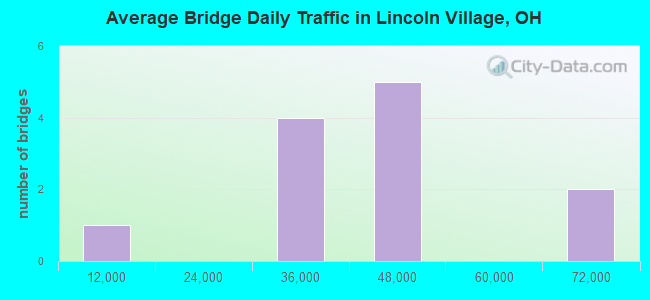
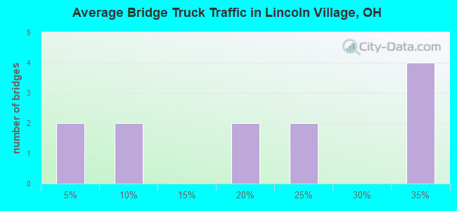
- National Bridge Inventory (NBI) Statistics
- 12Number of bridges
- 118ft / 35.9mTotal length
- 449,899Total average daily traffic
- 78,866Total average daily truck traffic
- National Bridge Inventory (NBI) Registered Bridges for Lincoln Village
- No street view available for this location
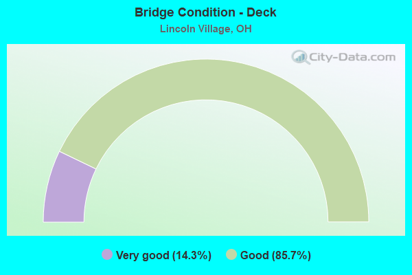
- Bridge Condition - Deck
- 14.3%Very good
- 85.7%Good
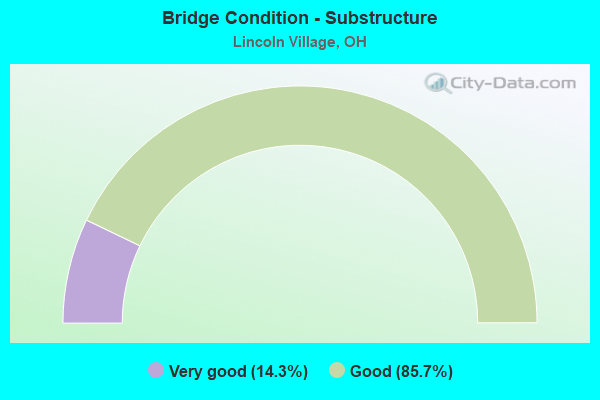
- Bridge Condition - Substructure
- 14.3%Very good
- 85.7%Good
Find on map >> Show street view
Structure Number: 2512181, Location: 0.77 MI N OF US40 (Lat: 39.963561, Lng: -83.119189), Route carried "on" structure: Interstate 270, Year Built: 1969, Status: Open, Structure Length: 6.19m (20.31ft), Average Daily Traffic: 39,643 (year 2015), Truck Traffic: 21%, Average Future Daily Traffic: 55,024 (year 2035), Design Load: HS 20+Mod, Features Intersected: OVER NS RR
Minimum Vertical Clearance: 30+ m (98+ ft), Kilometerpoint: 12.569, Lanes on structure: 4, Base Highway Network: Yes, Owner: State Highway Agency, Approaching Roadway Width: 21.3m (69.9ft), Skew: 9 degrees, Material/Design: Steel continuous, Design/Construction: Stringer/Multi-beam, Number Of Spans In Main Unit: 4, Length of Maximum Span: 25.0m (82.0ft), Curb-To-Curb Width: 21.3m (69.9ft), Out-to-Out Width: 22.3m (73.2ft)
Condition: Deck: Good, Superstructure: Good, Substructure: Good, Operating Rating: 35.6 metric tons, Method Used To Determine Operating Rating: Allowable Stress (AS) rating reported by rating factor (RF) method using MS18 loading, Inventory Rating: 32.4 metric tons, Method Used To Determine Inventory Rating: Allowable Stress (AS) rating reported by rating factor (RF) method using MS18 loading, Structural Evaluation: Better than present minimum criteria, Deck Geometry: Better than present minimum criteria, Underclear: Superior to present desirable criteria, Approach Roadway Alignment: Better than present minimum criteria, Designated Inspection Frequency: Every 24 months, Inspection Date: November 2021, Deck Structure Type: Concrete Cast-file-Place, Wearing Surface/Protective System: Wearing Surface: Latex Concrete
Find on map >> Show street view
Structure Number: 2512211, Location: 0.77 MI N OF US40 (Lat: 39.963561, Lng: -83.119450), Route carried "on" structure: Interstate 270, Year Built: 1969, Status: Open, Structure Length: 6.16m (20.21ft), Average Daily Traffic: 39,643 (year 2015), Truck Traffic: 21%, Average Future Daily Traffic: 55,024 (year 2035), Design Load: HS 20+Mod, Features Intersected: OVER NS RR
Minimum Vertical Clearance: 30+ m (98+ ft), Kilometerpoint: 12.569, Lanes on structure: 4, Base Highway Network: Yes, Owner: State Highway Agency, Approaching Roadway Width: 21.3m (69.9ft), Material/Design: Steel continuous, Design/Construction: Stringer/Multi-beam, Number Of Spans In Main Unit: 3, Length of Maximum Span: 22.6m (74.1ft), Curb-To-Curb Width: 21.3m (69.9ft), Out-to-Out Width: 22.3m (73.2ft)
Condition: Deck: Very good, Superstructure: Good, Substructure: Good, Operating Rating: 58.3 metric tons, Method Used To Determine Operating Rating: Load Factor (LF) rating reported by rating factor (RF) method using MS18 loading, Inventory Rating: 35.6 metric tons, Method Used To Determine Inventory Rating: Load Factor (LF) rating reported by rating factor (RF) method using MS18 loading, Structural Evaluation: Better than present minimum criteria, Deck Geometry: Better than present minimum criteria, Underclear: Somewhat better than minimum adequacy, Approach Roadway Alignment: Better than present minimum criteria, Designated Inspection Frequency: Every 24 months, Inspection Date: November 2022, Deck Structure Type: Concrete Cast-file-Place, Wearing Surface/Protective System: Wearing Surface: Latex Concrete
Find on map >> Show street view
Structure Number: 251227, Location: 0.04 MI E OF SR270 (Lat: 39.952489, Lng: -83.118669), Route carried "on" structure: Ramp Interstate 270, Year Built: 1969, Status: Open, Structure Length: 5.21m (17.09ft), Average Daily Traffic: 8,060 (year 2017), Truck Traffic: 3%, Average Future Daily Traffic: 11,187 (year 2037), Design Load: HS 20+Mod, Features Intersected: US-40
Minimum Vertical Clearance: 30+ m (98+ ft), Kilometerpoint: 11.330, Lanes on structure: 1, Lanes under structure: 5, Owner: State Highway Agency, Approaching Roadway Width: 9.4m (30.8ft), Material/Design: Steel continuous, Design/Construction: Stringer/Multi-beam, Number Of Spans In Main Unit: 4, Length of Maximum Span: 16.8m (55.1ft), Curb-To-Curb Width: 8.5m (27.9ft), Out-to-Out Width: 9.5m (31.2ft)
Condition: Deck: Good, Superstructure: Good, Substructure: Very good, Operating Rating: 42.1 metric tons, Method Used To Determine Operating Rating: Load Factor (LF) rating reported by rating factor (RF) method using MS18 loading, Inventory Rating: 32.4 metric tons, Method Used To Determine Inventory Rating: Load Factor (LF) rating reported by rating factor (RF) method using MS18 loading, Structural Evaluation: Better than present minimum criteria, Deck Geometry: Superior to present desirable criteria, Underclear: High priority of corrective action, Approach Roadway Alignment: Equal to present desirable criteria, Designated Inspection Frequency: Every 24 months, Inspection Date: May 2021, Deck Structure Type: Concrete Cast-file-Place, Wearing Surface/Protective System: Wearing Surface: Latex Concrete
Find on map >> Show street view
Structure Number: 25123, Location: 7.04 MI N OF I71 (Lat: 39.952719, Lng: -83.119011), Route carried "on" structure: Interstate 270, Year Built: 1969, Status: Open, Structure Length: 5.21m (17.09ft), Average Daily Traffic: 25,007 (year 2015), Truck Traffic: 34%, Average Future Daily Traffic: 34,710 (year 2035), Design Load: HS 20+Mod, Features Intersected: OVER USR 40
Minimum Vertical Clearance: 30+ m (98+ ft), Kilometerpoint: 11.330, Lanes on structure: 3, Lanes under structure: 5, Base Highway Network: Yes, Owner: State Highway Agency, Approaching Roadway Width: 15.9m (52.2ft), Material/Design: Steel continuous, Design/Construction: Stringer/Multi-beam, Number Of Spans In Main Unit: 4, Length of Maximum Span: 16.8m (55.1ft), Curb-To-Curb Width: 16.2m (53.1ft), Out-to-Out Width: 17.1m (56.1ft)
Condition: Deck: Good, Superstructure: Good, Substructure: Good, Operating Rating: 74.5 metric tons, Method Used To Determine Operating Rating: Load and Resistance Factor Rating (LRFR) rating reported by rating factor(RF) method using HL-93 loadings, Inventory Rating: 58.3 metric tons, Method Used To Determine Inventory Rating: Load and Resistance Factor Rating (LRFR) rating reported by rating factor(RF) method using HL-93 loadings, Structural Evaluation: Better than present minimum criteria, Deck Geometry: Equal to present minimum criteria, Underclear: Meets minimum limits, Approach Roadway Alignment: Better than present minimum criteria, Designated Inspection Frequency: Every 24 months, Inspection Date: November 2021, Deck Structure Type: Concrete Cast-file-Place, Wearing Surface/Protective System: Wearing Surface: Latex Concrete
Find on map >> Show street view
Structure Number: 2512335, Location: 7.04 MI N OF I71 (Lat: 39.952700, Lng: -83.119269), Route carried "on" structure: Interstate 270, Year Built: 1969, Status: Open, Structure Length: 5.21m (17.09ft), Average Daily Traffic: 25,007 (year 2015), Truck Traffic: 34%, Average Future Daily Traffic: 34,710 (year 2035), Design Load: HS 20+Mod, Features Intersected: OVER USR 40
Minimum Vertical Clearance: 30+ m (98+ ft), Kilometerpoint: 11.330, Lanes on structure: 4, Lanes under structure: 5, Base Highway Network: Yes, Owner: State Highway Agency, Approaching Roadway Width: 18.3m (60.0ft), Material/Design: Steel continuous, Design/Construction: Stringer/Multi-beam, Number Of Spans In Main Unit: 4, Length of Maximum Span: 16.8m (55.1ft), Curb-To-Curb Width: 19.5m (64.0ft), Out-to-Out Width: 20.5m (67.3ft)
Condition: Deck: Good, Superstructure: Good, Substructure: Good, Operating Rating: 35.6 metric tons, Method Used To Determine Operating Rating: Allowable Stress (AS) rating reported by rating factor (RF) method using MS18 loading, Inventory Rating: 32.4 metric tons, Method Used To Determine Inventory Rating: Allowable Stress (AS) rating reported by rating factor (RF) method using MS18 loading, Structural Evaluation: Better than present minimum criteria, Deck Geometry: Somewhat better than minimum adequacy, Underclear: Meets minimum limits, Approach Roadway Alignment: Better than present minimum criteria, Designated Inspection Frequency: Every 24 months, Inspection Date: November 2021, Deck Structure Type: Concrete Cast-file-Place, Wearing Surface/Protective System: Wearing Surface: Latex Concrete
Find on map >> Show street view
Structure Number: 2512394, Location: 0.3 MI S OF US40 (Lat: 39.950600, Lng: -83.119361), Route carried "on" structure: Interstate 270, Year Built: 1969, Status: Open, Structure Length: 4.22m (13.85ft), Average Daily Traffic: 25,007 (year 2015), Truck Traffic: 34%, Average Future Daily Traffic: 34,710 (year 2035), Design Load: HS 20+Mod, Features Intersected: OVR RMP USR40E TO IR270N
Minimum Vertical Clearance: 30+ m (98+ ft), Kilometerpoint: 11.121, Lanes on structure: 3, Lanes under structure: 1, Base Highway Network: Yes, Owner: State Highway Agency, Approaching Roadway Width: 19.6m (64.3ft), Skew: 3 degrees, Material/Design: Steel continuous, Design/Construction: Stringer/Multi-beam, Number Of Spans In Main Unit: 3, Length of Maximum Span: 14.6m (47.9ft), Curb-To-Curb Width: 19.6m (64.3ft), Out-to-Out Width: 20.5m (67.3ft)
Condition: Deck: Good, Superstructure: Good, Substructure: Good, Operating Rating: 77.8 metric tons, Method Used To Determine Operating Rating: Load and Resistance Factor Rating (LRFR) rating reported by rating factor(RF) method using HL-93 loadings, Inventory Rating: 61.6 metric tons, Method Used To Determine Inventory Rating: Load and Resistance Factor Rating (LRFR) rating reported by rating factor(RF) method using HL-93 loadings, Structural Evaluation: Better than present minimum criteria, Deck Geometry: Superior to present desirable criteria, Underclear: High priority of corrective action, Approach Roadway Alignment: Better than present minimum criteria, Designated Inspection Frequency: Every 24 months, Inspection Date: November 2021, Deck Structure Type: Concrete Cast-file-Place, Wearing Surface/Protective System: Wearing Surface: Latex Concrete
Find on map >> Show street view
Structure Number: 2512424, Location: 0.13 MI S OF US40 (Lat: 39.950561, Lng: -83.119481), Route carried "on" structure: Interstate 270, Year Built: 1969, Status: Open, Structure Length: 3.72m (12.20ft), Average Daily Traffic: 25,007 (year 2015), Truck Traffic: 34%, Average Future Daily Traffic: 34,710 (year 2035), Design Load: HS 20+Mod, Features Intersected: OV RMP USR40E TO IR270N
Minimum Vertical Clearance: 30+ m (98+ ft), Kilometerpoint: 11.121, Lanes on structure: 3, Lanes under structure: 1, Base Highway Network: Yes, Owner: State Highway Agency, Approaching Roadway Width: 15.9m (52.2ft), Skew: 2 degrees, Material/Design: Steel continuous, Design/Construction: Stringer/Multi-beam, Number Of Spans In Main Unit: 3, Length of Maximum Span: 12.8m (42.0ft), Curb-To-Curb Width: 16.2m (53.1ft), Out-to-Out Width: 17.1m (56.1ft)
Condition: Deck: Good, Superstructure: Good, Substructure: Good, Operating Rating: 71.3 metric tons, Method Used To Determine Operating Rating: Load and Resistance Factor Rating (LRFR) rating reported by rating factor(RF) method using HL-93 loadings, Inventory Rating: 55.1 metric tons, Method Used To Determine Inventory Rating: Load and Resistance Factor Rating (LRFR) rating reported by rating factor(RF) method using HL-93 loadings, Structural Evaluation: Better than present minimum criteria, Deck Geometry: Equal to present minimum criteria, Underclear: Meets minimum limits, Approach Roadway Alignment: Better than present minimum criteria, Designated Inspection Frequency: Every 24 months, Inspection Date: November 2021, Deck Structure Type: Concrete Cast-file-Place, Wearing Surface/Protective System: Wearing Surface: Latex Concrete
Find on map >> Show street view
Structure Number: 251227, Location: 0.04 MI E OF SR270 (Lat: 39.952489, Lng: -83.118669), Route carried "under" structure: US 40, Year Built: 1969, Structure Length: 0. m, Average Daily Traffic: 41,063 (year 2017), Truck Traffic: 3%, Features Intersected: RAMP US40 TO 270N
Minimum Vertical Clearance: 4.62m (15.16ft), Kilometerpoint: 10.091, Lanes on structure: 1, Lanes under structure: 5, Material/Design: Steel continuous, Design/Construction: Stringer/Multi-beam, Length of Maximum Span: 16.8m (55.1ft)
Find on map >> Show street view
Structure Number: 25123, Location: 7.04 MI N OF I71 (Lat: 39.952719, Lng: -83.119011), Route carried "under" structure: US 40, Year Built: 1969, Structure Length: 0. m, Average Daily Traffic: 39,531 (year 2015), Truck Traffic: 5%, Features Intersected: IR 270NB, Facility Carried by Structure: I-270
Minimum Vertical Clearance: 5.26m (17.26ft), Kilometerpoint: 100.584, Lanes on structure: 3, Lanes under structure: 5, Material/Design: Steel continuous, Design/Construction: Stringer/Multi-beam, Length of Maximum Span: 16.8m (55.1ft)
Find on map >> Show street view
Structure Number: 2512335, Location: 7.04 MI N OF I71 (Lat: 39.952700, Lng: -83.119269), Route carried "under" structure: US 40, Year Built: 1969, Structure Length: 0. m, Average Daily Traffic: 39,531 (year 2015), Truck Traffic: 5%, Features Intersected: IR 270SB, Facility Carried by Structure: I-270
Minimum Vertical Clearance: 4.90m (16.08ft), Kilometerpoint: 100.262, Lanes on structure: 4, Lanes under structure: 5, Material/Design: Steel continuous, Design/Construction: Stringer/Multi-beam, Length of Maximum Span: 16.8m (55.1ft)
Find on map >> Show street view
Structure Number: 2512394, Location: 0.3 MI S OF US40 (Lat: 39.950600, Lng: -83.119361), Route carried "under" structure: Ramp Interstate 270, Year Built: 1969, Structure Length: 0. m, Average Daily Traffic: 71,200 (year 2010), Truck Traffic: 16%, Features Intersected: I-270 NB
Minimum Vertical Clearance: 4.50m (14.76ft), Kilometerpoint: 111.206, Lanes on structure: 3, Lanes under structure: 1, Material/Design: Steel continuous, Design/Construction: Stringer/Multi-beam, Length of Maximum Span: 14.6m (47.9ft)
Find on map >> Show street view
Structure Number: 2512424, Location: 0.13 MI S OF US40 (Lat: 39.950561, Lng: -83.119481), Route carried "under" structure: Ramp Interstate 270, Year Built: 1969, Structure Length: 0. m, Average Daily Traffic: 71,200 (year 2010), Truck Traffic: 16%, Features Intersected: I-270 SB
Minimum Vertical Clearance: 4.72m (15.49ft), Kilometerpoint: 111.206, Lanes on structure: 3, Lanes under structure: 1, Material/Design: Steel continuous, Design/Construction: Stringer/Multi-beam, Length of Maximum Span: 12.8m (42.0ft)