Bridge Statistics for Lodi, New Jersey (NJ)
Condition, Traffic, Stress, Structural Evaluation, Project Costs
- National Bridge Inventory (NBI) Statistics
- 18Number of bridges
- 180ft / 55.1mTotal length
- $71,816,000Total costs
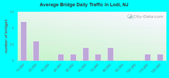
- 688,845Total average daily traffic
- 40,004Total average daily truck traffic
- National Bridge Inventory (NBI) Registered Bridges for Lodi
- No street view available for this location
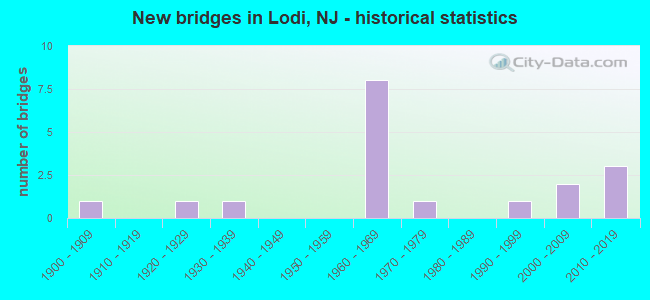
- New bridges - historical statistics
- 11900-1909
- 11920-1929
- 11930-1939
- 81960-1969
- 11970-1979
- 11990-1999
- 22000-2009
- 32010-2019
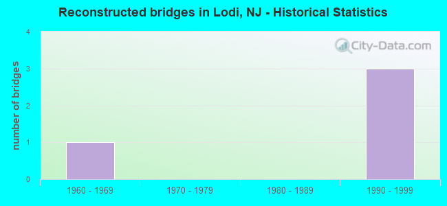
- Reconstructed bridges - Historical Statistics
- 11960-1969
- 01970-1979
- 01980-1989
- 31990-1999
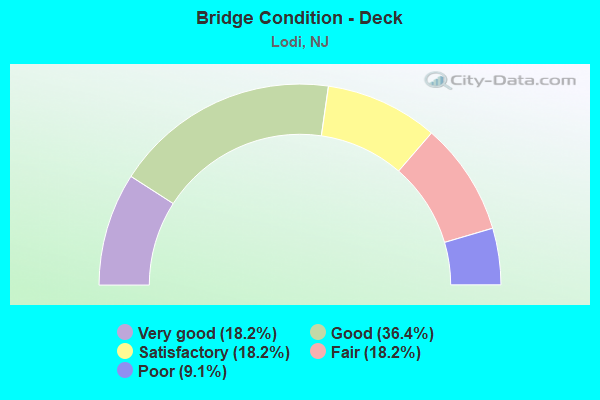
- Bridge Condition - Deck
- 18.2%Very good
- 36.4%Good
- 18.2%Satisfactory
- 18.2%Fair
- 9.1%Poor
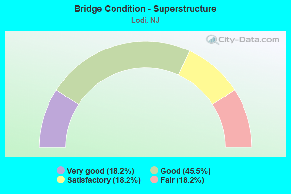
- Bridge Condition - Superstructure
- 18.2%Very good
- 45.5%Good
- 18.2%Satisfactory
- 18.2%Fair
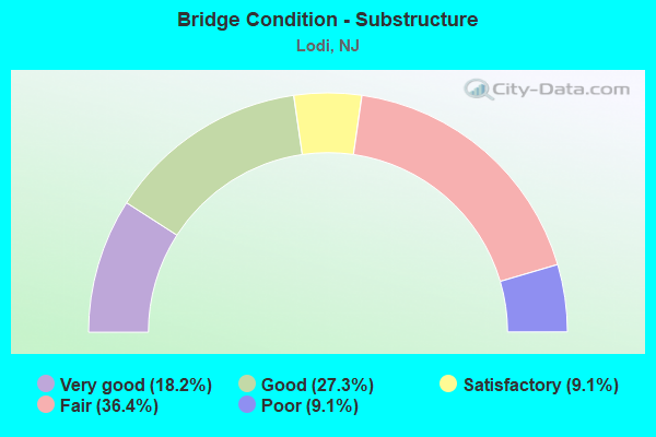
- Bridge Condition - Substructure
- 18.2%Very good
- 27.3%Good
- 9.1%Satisfactory
- 36.4%Fair
- 9.1%Poor
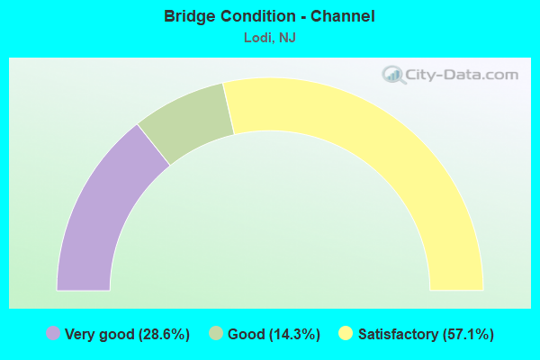
- Bridge Condition - Channel
- 28.6%Very good
- 14.3%Good
- 57.1%Satisfactory
Find on map >> Show street view
Structure Number: 20031A, Location: 0.10 MI EAST OF CR 79 (Lat: 40.895111, Lng: -74.078611), Route carried "on" structure: County highway 56I, Year Built: 1923, Status: Open, Structure Length: 2.77m (9.09ft), Average Daily Traffic: 35,123 (year 2020), Truck Traffic: 4%, Average Future Daily Traffic: 42,856 (year 2040), Features Intersected: SADDLE RIVER, Facility Carried by Structure: ESSEX ST (CR 56 I)
Minimum Vertical Clearance: 4.34m (14.24ft), Kilometerpoint: 4.699, Lanes on structure: 2, Owner: County Highway Agency, Approaching Roadway Width: 9.1m (29.9ft), Material/Design: Steel, Design/Construction: Stringer/Multi-beam, Number Of Spans In Main Unit: 2, Length of Maximum Span: 12.8m (42.0ft), Curb or Sidewalk Widths: Left: 2.5m (8.2ft), Right: 0.3m (1.0ft), Curb-To-Curb Width: 9.1m (29.9ft), Out-to-Out Width: 12.7m (41.7ft)
Condition: Deck: Fair, Superstructure: Satisfactory, Substructure: Fair, Channel: Very good, Operating Rating: 57.2 metric tons, Method Used To Determine Operating Rating: Load Factor (LF), Inventory Rating: 34.5 metric tons, Method Used To Determine Inventory Rating: Load Factor (LF), Structural Evaluation: Somewhat better than minimum adequacy, Deck Geometry: High priority of corrective action, Waterway Adequacy: Superior to present desirable criteria, Approach Roadway Alignment: Better than present minimum criteria, Length Of Structure Improvement: 2.77m (9.09ft), Designated Inspection Frequency: Every 24 months, Inspection Date: May 2020, Bridge Improvement Cost: $54,000, Roadway Improvement Cost: $54,000, Total Project Cost: $300,000 ( Estimate for 2020), Deck Structure Type: Concrete Cast-file-Place, Wearing Surface/Protective System: Wearing Surface: Bituminous
Find on map >> Show street view
Structure Number: 20031B, Location: 0.02 MI. E OF 1ST STREET (Lat: 40.873439, Lng: -74.089089), Route carried "on" structure: County highway 40I, Year Built: 1902, Year Reconstructed: 1971, Status: Posted for load, Structure Length: 1.92m (6.30ft), Average Daily Traffic: 9,596 (year 2020), Truck Traffic: 4%, Average Future Daily Traffic: 11,709 (year 2040), Design Load: H 15, Features Intersected: SADDLE RIVER
Minimum Vertical Clearance: 30+ m (98+ ft), Kilometerpoint: 2.060, Lanes on structure: 2, Owner: County Highway Agency, Approaching Roadway Width: 11.0m (36.1ft), Material/Design: Steel, Design/Construction: Girder and Floorbeam System, Number Of Spans In Main Unit: 1, Length of Maximum Span: 18.9m (62.0ft), Curb or Sidewalk Widths: Left: 2.1m (6.9ft), Right: 2.1m (6.9ft), Curb-To-Curb Width: 9.6m (31.5ft), Out-to-Out Width: 10.0m (32.8ft)
Condition: Deck: Fair, Superstructure: Fair, Substructure: Fair, Channel: Satisfactory, Operating Rating: 24.5 metric tons, Method Used To Determine Operating Rating: Load Factor (LF), Inventory Rating: 14.5 metric tons, Method Used To Determine Inventory Rating: Load Factor (LF), Structural Evaluation: High priority of replacement, Deck Geometry: High priority of corrective action, Waterway Adequacy: Equal to present minimum criteria, Approach Roadway Alignment: Better than present minimum criteria, Bridge Posting: Required (Relationship of Operating Rating to Maximum Legal Load: 30.0 - 39.9% below), Length Of Structure Improvement: 1.92m (6.30ft), Designated Inspection Frequency: Every 24 months, Critical Feature Inspection Frequency: Every 24 months, Other Special Inspection Frequency: Every 12 months, Inspection Date: May 2020, Critical Feature Inspection Date: May 2020, Other Special Inspection Date: May 2021, Bridge Improvement Cost: $1,611,000, Roadway Improvement Cost: $330,000, Total Project Cost: $2,900,000 ( Estimate for 2020), Deck Structure Type: Open Grating, Wearing Surface/Protective System: Wearing Surface: Other
Find on map >> Show street view
Structure Number: 20031C, Location: 0.22 Mi. SE OF CR 40 (Lat: 40.869461, Lng: -74.090231), Route carried "on" structure: City street , Year Built: 1995, Status: Open, Structure Length: 2.68m (8.79ft), Average Daily Traffic: 3,439 (year 2020), Truck Traffic: 3%, Average Future Daily Traffic: 4,265 (year 2040), Design Load: HS 20+Mod, Features Intersected: SADDLE RIVER, Facility Carried by Structure: TERRACE AVENUE
Minimum Vertical Clearance: 30+ m (98+ ft), Kilometerpoint: 0.370, Lanes on structure: 2, Owner: County Highway Agency, Approaching Roadway Width: 9.1m (29.9ft), Material/Design: Steel, Design/Construction: Stringer/Multi-beam, Number Of Spans In Main Unit: 1, Length of Maximum Span: 25.0m (82.0ft), Curb or Sidewalk Widths: Left: 1.8m (5.9ft), Right: 1.8m (5.9ft), Curb-To-Curb Width: 9.1m (29.9ft), Out-to-Out Width: 13.5m (44.3ft)
Condition: Deck: Good, Superstructure: Good, Substructure: Good, Channel: Good, Inventory Rating: 89.8 metric tons, Method Used To Determine Inventory Rating: Load Factor (LF), Structural Evaluation: Better than present minimum criteria, Deck Geometry: Meets minimum limits, Waterway Adequacy: Better than present minimum criteria, Approach Roadway Alignment: Equal to present minimum criteria, Designated Inspection Frequency: Every 24 months, Inspection Date: May 2020, Deck Structure Type: Concrete Cast-file-Place, Wearing Surface/Protective System: Wearing Surface: Monolithic Concrete, Deck Protection: Epoxy Coated Reinforcing
Find on map >> Show street view
Structure Number: 20031D, Location: 0.11 MI W OF CR 40 (Lat: 40.877439, Lng: -74.087389), Route carried "on" structure: City street , Year Built: 2001, Status: Open, Structure Length: 2.68m (8.79ft), Average Daily Traffic: 1,416 (year 2020), Truck Traffic: 3%, Average Future Daily Traffic: 1,728 (year 2040), Design Load: HS 25 or greater, Features Intersected: SADDLE RIVER, Facility Carried by Structure: ARNOT STREET
Minimum Vertical Clearance: 30+ m (98+ ft), Kilometerpoint: 0.579, Lanes on structure: 2, Owner: County Highway Agency, Approaching Roadway Width: 9.1m (29.9ft), Skew: 1 degrees, Material/Design: Prestressed concrete, Design/Construction: Box Beam or Girders - Multiple, Number Of Spans In Main Unit: 1, Length of Maximum Span: 25.3m (83.0ft), Curb or Sidewalk Widths: Left: 1.8m (5.9ft), Right: 1.7m (5.6ft), Curb-To-Curb Width: 9.0m (29.5ft), Out-to-Out Width: 14.5m (47.6ft)
Condition: Deck: Satisfactory, Superstructure: Good, Substructure: Good, Channel: Very good, Operating Rating: 57.2 metric tons, Method Used To Determine Operating Rating: Load Factor (LF), Inventory Rating: 34.5 metric tons, Method Used To Determine Inventory Rating: Load Factor (LF), Structural Evaluation: Better than present minimum criteria, Deck Geometry: Somewhat better than minimum adequacy, Waterway Adequacy: Superior to present desirable criteria, Approach Roadway Alignment: Better than present minimum criteria, Designated Inspection Frequency: Every 24 months, Inspection Date: May 2020, Deck Structure Type: Concrete Cast-file-Place, Wearing Surface/Protective System: Wearing Surface: Monolithic Concrete, Deck Protection: Epoxy Coated Reinforcing
Find on map >> Show street view
Structure Number: 20031E, Location: 0.02 MI W of Main St. (Lat: 40.885039, Lng: -74.082911), Route carried "on" structure: City street , Year Built: 2003, Status: Open, Structure Length: 2.01m (6.59ft), Average Daily Traffic: 3,521 (year 2020), Truck Traffic: 1%, Average Future Daily Traffic: 4,225 (year 2040), Design Load: HS 25 or greater, Features Intersected: SADDLE RIVER, Facility Carried by Structure: BORIG PLACE
Minimum Vertical Clearance: 30+ m (98+ ft), Kilometerpoint: 0.000, Lanes on structure: 2, Owner: County Highway Agency, Approaching Roadway Width: 8.8m (28.9ft), Material/Design: Prestressed concrete, Design/Construction: Box Beam or Girders - Multiple, Number Of Spans In Main Unit: 1, Length of Maximum Span: 18.9m (62.0ft), Curb or Sidewalk Widths: Left: 2.8m (9.2ft), Right: 2.8m (9.2ft), Curb-To-Curb Width: 8.8m (28.9ft), Out-to-Out Width: 15.1m (49.5ft)
Condition: Deck: Very good, Superstructure: Good, Substructure: Good, Channel: Satisfactory, Operating Rating: 71.7 metric tons, Method Used To Determine Operating Rating: Load Factor (LF), Inventory Rating: 42.6 metric tons, Method Used To Determine Inventory Rating: Load Factor (LF), Structural Evaluation: Better than present minimum criteria, Deck Geometry: Meets minimum limits, Waterway Adequacy: Equal to present minimum criteria, Approach Roadway Alignment: Equal to present minimum criteria, Designated Inspection Frequency: Every 24 months, Inspection Date: April 2020, Deck Structure Type: Concrete Cast-file-Place, Wearing Surface/Protective System: Wearing Surface: Monolithic Concrete, Deck Protection: Epoxy Coated Reinforcing
Find on map >> Show street view
Structure Number: 20031F, Location: 0.54 MI EAST OF US RT 46 (Lat: 40.888939, Lng: -74.081811), Route carried "on" structure: County highway 42, Year Built: 1976, Status: Open, Structure Length: 3.11m (10.20ft), Average Daily Traffic: 15,697 (year 2020), Truck Traffic: 4%, Average Future Daily Traffic: 19,153 (year 2040), Design Load: HS 20+Mod, Features Intersected: SADDLE RIVER
Minimum Vertical Clearance: 30+ m (98+ ft), Kilometerpoint: 3.428, Lanes on structure: 2, Owner: County Highway Agency, Approaching Roadway Width: 11.0m (36.1ft), Skew: 1 degrees, Material/Design: Steel, Design/Construction: Stringer/Multi-beam, Number Of Spans In Main Unit: 1, Length of Maximum Span: 29.6m (97.1ft), Curb or Sidewalk Widths: Left: 1.8m (5.9ft), Right: 1.8m (5.9ft), Curb-To-Curb Width: 10.9m (35.8ft), Out-to-Out Width: 15.7m (51.5ft)
Condition: Deck: Satisfactory, Superstructure: Good, Substructure: Satisfactory, Channel: Satisfactory, Inventory Rating: 65.3 metric tons, Method Used To Determine Inventory Rating: Load Factor (LF), Structural Evaluation: Equal to present minimum criteria, Deck Geometry: Meets minimum limits, Waterway Adequacy: Superior to present desirable criteria, Approach Roadway Alignment: Equal to present minimum criteria, Designated Inspection Frequency: Every 24 months, Inspection Date: June 2020, Deck Structure Type: Concrete Cast-file-Place, Wearing Surface/Protective System: Wearing Surface: Monolithic Concrete
Find on map >> Show street view
Structure Number: 220157, Location: 2.1 Mile East of GSP (Lat: 40.882481, Lng: -74.084519), Route carried "on" structure: US 46, Year Built: 2011, Status: Open, Structure Length: 3.87m (12.70ft), Average Daily Traffic: 73,021 (year 2020), Truck Traffic: 4%, Average Future Daily Traffic: 89,099 (year 2040), Design Load: HL 93, Features Intersected: SADDLE RIVER
Minimum Vertical Clearance: 30+ m (98+ ft), Kilometerpoint: 107.037, Lanes on structure: 6, Base Highway Network: Yes, Owner: State Highway Agency, Approaching Roadway Width: 26.9m (88.3ft), Skew: 30 degrees, Material/Design: Steel, Design/Construction: Stringer/Multi-beam, Number Of Spans In Main Unit: 1, Length of Maximum Span: 37.8m (124.0ft), Curb or Sidewalk Widths: Left: 1.8m (5.9ft), Right: 2.4m (7.9ft), Curb-To-Curb Width: 26.9m (88.3ft), Out-to-Out Width: 32.8m (107.6ft)
Condition: Deck: Good, Superstructure: Very good, Substructure: Very good, Channel: Satisfactory, Operating Rating: 69.3 metric tons, Method Used To Determine Operating Rating: Load and Resistance Factor Rating (LRFR) rating reported by rating factor(RF) method using HL-93 loadings, Inventory Rating: 55.4 metric tons, Method Used To Determine Inventory Rating: Load and Resistance Factor Rating (LRFR) rating reported by rating factor(RF) method using HL-93 loadings, Structural Evaluation: Equal to present desirable criteria, Deck Geometry: Better than present minimum criteria, Waterway Adequacy: Equal to present desirable criteria, Approach Roadway Alignment: Better than present minimum criteria, Designated Inspection Frequency: Every 24 months, Inspection Date: March 2020, Deck Structure Type: Concrete Cast-file-Place, Wearing Surface/Protective System: Wearing Surface: Monolithic Concrete, Deck Protection: Epoxy Coated Reinforcing
Find on map >> Show street view
Structure Number: 220158, Location: 1.55 Mile West of RT 17 (Lat: 40.882119, Lng: -74.083769), Route carried "on" structure: US 46, Year Built: 2011, Status: Open, Structure Length: 2.80m (9.19ft), Average Daily Traffic: 73,021 (year 2020), Truck Traffic: 4%, Average Future Daily Traffic: 89,099 (year 2040), Design Load: HL 93, Features Intersected: MAIN STREET (CR 61)
Minimum Vertical Clearance: 30+ m (98+ ft), Kilometerpoint: 107.118, Lanes on structure: 6, Lanes under structure: 4, Base Highway Network: Yes, Owner: State Highway Agency, Approaching Roadway Width: 27.4m (89.9ft), Skew: 31 degrees, Material/Design: Steel, Design/Construction: Stringer/Multi-beam, Number Of Spans In Main Unit: 1, Length of Maximum Span: 27.4m (89.9ft), Curb or Sidewalk Widths: Left: 1.8m (5.9ft), Right: 2.4m (7.9ft), Curb-To-Curb Width: 27.7m (90.9ft), Out-to-Out Width: 32.8m (107.6ft)
Condition: Deck: Very good, Superstructure: Very good, Substructure: Very good, Operating Rating: 96.9 metric tons, Method Used To Determine Operating Rating: Load and Resistance Factor Rating (LRFR) rating reported by rating factor(RF) method using HL-93 loadings, Inventory Rating: 80.0 metric tons, Method Used To Determine Inventory Rating: Load and Resistance Factor Rating (LRFR) rating reported by rating factor(RF) method using HL-93 loadings, Structural Evaluation: Equal to present desirable criteria, Deck Geometry: Equal to present desirable criteria, Underclear: Somewhat better than minimum adequacy, Approach Roadway Alignment: Equal to present desirable criteria, Designated Inspection Frequency: Every 24 months, Inspection Date: March 2020, Deck Structure Type: Concrete Cast-file-Place, Wearing Surface/Protective System: Wearing Surface: Monolithic Concrete, Deck Protection: Epoxy Coated Reinforcing
Find on map >> Show street view
Structure Number: 225167, Location: 0.6 MI WEST OF RTE 17SB (Lat: 40.892611, Lng: -74.076239), Route carried "on" structure: City street , Year Built: 1962, Year Reconstructed: 2004, Status: Open, Structure Length: 5.82m (19.09ft), Average Daily Traffic: 14,135 (year 2021), Truck Traffic: 1%, Average Future Daily Traffic: 17,247 (year 2041), Design Load: HS 20, Features Intersected: I-80, Facility Carried by Structure: RIVERVIEW AVENUE
Minimum Vertical Clearance: 30+ m (98+ ft), Kilometerpoint: 0.000, Lanes on structure: 2, Lanes under structure: 9, Owner: State Highway Agency, Approaching Roadway Width: 9.1m (29.9ft), Material/Design: Steel, Design/Construction: Stringer/Multi-beam, Number Of Spans In Main Unit: 2, Length of Maximum Span: 31.4m (103.0ft), Curb or Sidewalk Widths: Left: 1.8m (5.9ft), Right: 1.8m (5.9ft), Curb-To-Curb Width: 9.1m (29.9ft), Out-to-Out Width: 13.4m (44.0ft)
Condition: Deck: Poor, Superstructure: Good, Substructure: Fair, Inventory Rating: 63.5 metric tons, Method Used To Determine Inventory Rating: Load Factor (LF), Structural Evaluation: Somewhat better than minimum adequacy, Deck Geometry: High priority of corrective action, Underclear: High priority of corrective action, Approach Roadway Alignment: Equal to present minimum criteria, Length Of Structure Improvement: 5.82m (19.09ft), Designated Inspection Frequency: Every 24 months, Inspection Date: November 2021, Bridge Improvement Cost: $2,013,000, Roadway Improvement Cost: $200,000, Total Project Cost: $2,616,000 ( Estimate for 2021), Deck Structure Type: Concrete Cast-file-Place, Wearing Surface/Protective System: Wearing Surface: Latex Concrete, Deck Protection: Epoxy Coated Reinforcing
Find on map >> Show street view
Structure Number: 22615, Location: 3.4 MI. W. OF RTE I-95 (Lat: 40.885800, Lng: -74.068700), Route carried "on" structure: Interstate 80, Year Built: 1962, Year Reconstructed: 2003, Status: Open, Structure Length: 14.30m (46.92ft), Average Daily Traffic: 40,915 (year 2021), Truck Traffic: 9%, Average Future Daily Traffic: 49,100 (year 2041), Design Load: HS 25 or greater, Features Intersected: 17 SB,GREGG ST,NYS&W RR
Minimum Vertical Clearance: 30+ m (98+ ft), Kilometerpoint: 103.690, Lanes on structure: 3, Lanes under structure: 5, Base Highway Network: Yes, Owner: State Highway Agency, Approaching Roadway Width: 15.2m (49.9ft), Skew: 26 degrees, Material/Design: Steel, Design/Construction: Stringer/Multi-beam, Number Of Spans In Main Unit: 4, Length of Maximum Span: 70.7m (232.0ft), Curb-To-Curb Width: 15.2m (49.9ft), Out-to-Out Width: 16.6m (54.5ft)
Condition: Deck: Good, Superstructure: Satisfactory, Substructure: Fair, Operating Rating: 35.4 metric tons, Method Used To Determine Operating Rating: Load Factor (LF), Inventory Rating: 20.9 metric tons, Method Used To Determine Inventory Rating: Load Factor (LF), Structural Evaluation: Somewhat better than minimum adequacy, Deck Geometry: Meets minimum limits, Underclear: Equal to present minimum criteria, Approach Roadway Alignment: Equal to present desirable criteria, Designated Inspection Frequency: Every 24 months, Critical Feature Inspection Frequency: Every 24 months, Inspection Date: July 2021, Critical Feature Inspection Date: July 2021, Deck Structure Type: Concrete Cast-file-Place, Wearing Surface/Protective System: Wearing Surface: Bituminous, Membrane: Preformed Fabric, Deck Protection: Epoxy Coated Reinforcing
Find on map >> Show street view
Structure Number: 226151, Location: 3.4 MI WEST OF RTE I-95 (Lat: 40.885939, Lng: -74.068561), Route carried "on" structure: Interstate 80, Year Built: 1963, Year Reconstructed: 2002, Status: Open, Structure Length: 13.17m (43.21ft), Average Daily Traffic: 109,110 (year 2021), Truck Traffic: 9%, Average Future Daily Traffic: 130,930 (year 2041), Design Load: HS 25 or greater, Features Intersected: RTE 17SB, GREGG ST & RR
Minimum Vertical Clearance: 30+ m (98+ ft), Kilometerpoint: 103.690, Lanes on structure: 8, Lanes under structure: 5, Base Highway Network: Yes, Owner: State Highway Agency, Approaching Roadway Width: 40.5m (132.9ft), Skew: 32 degrees, Material/Design: Steel, Design/Construction: Stringer/Multi-beam, Number Of Spans In Main Unit: 4, Length of Maximum Span: 61.9m (203.1ft), Curb-To-Curb Width: 40.2m (131.9ft), Out-to-Out Width: 44.3m (145.3ft)
Condition: Deck: Good, Superstructure: Fair, Substructure: Poor, Operating Rating: 35.4 metric tons, Method Used To Determine Operating Rating: Load Factor (LF), Inventory Rating: 20.9 metric tons, Method Used To Determine Inventory Rating: Load Factor (LF), Structural Evaluation: Meets minimum limits, Deck Geometry: Superior to present desirable criteria, Underclear: Somewhat better than minimum adequacy, Approach Roadway Alignment: Equal to present desirable criteria, Length Of Structure Improvement: 13.26m (43.50ft), Designated Inspection Frequency: Every 24 months, Critical Feature Inspection Frequency: Every 24 months, Inspection Date: July 2021, Critical Feature Inspection Date: July 2021, Bridge Improvement Cost: $59,312,000, Roadway Improvement Cost: $2,965,000, Total Project Cost: $66,000,000 ( Estimate for 2021), Deck Structure Type: Concrete Cast-file-Place, Wearing Surface/Protective System: Wearing Surface: Latex Concrete, Deck Protection: Epoxy Coated Reinforcing
Find on map >> Show street view
Structure Number: 220155, Location: 1.6 MILES EAST OF GSP (Lat: 40.886639, Lng: -74.091619), Route carried "under" structure: US 46, Year Built: 1936, Structure Length: 0. m, Average Daily Traffic: 69,500 (year 2021), Truck Traffic: 4%, Features Intersected: US 46, Facility Carried by Structure: OUTWATER LANE
Minimum Vertical Clearance: 5.21m (17.09ft), Kilometerpoint: 106.265, Lanes on structure: 2, Lanes under structure: 4, Material/Design: Steel, Design/Construction: Stringer/Multi-beam, Length of Maximum Span: 14.6m (47.9ft)
Find on map >> Show street view
Structure Number: 220158, Location: 1.55 Mile West of RT 17 (Lat: 40.882119, Lng: -74.083769), Route carried "under" structure: County highway 61, Year Built: 2011, Structure Length: 0. m, Average Daily Traffic: 17,177 (year 2020), Truck Traffic: 4%, Features Intersected: MAIN STREET (CR 61), Facility Carried by Structure: ROUTE US 46
Minimum Vertical Clearance: 4.75m (15.58ft), Kilometerpoint: 3.524, Lanes on structure: 6, Lanes under structure: 4, Material/Design: Steel, Design/Construction: Stringer/Multi-beam, Length of Maximum Span: 27.4m (89.9ft)
Find on map >> Show street view
Structure Number: 225167, Location: 0.6 MI WEST OF RTE 17SB (Lat: 40.892611, Lng: -74.076239), Route carried "under" structure: Interstate 80, Year Built: 1962, Structure Length: 0. m, Average Daily Traffic: 112,488 (year 2021), Truck Traffic: 9%, Features Intersected: I-80, Facility Carried by Structure: RIVERVIEW AVENUE
Minimum Vertical Clearance: 6.61m (21.69ft), Kilometerpoint: 102.708, Lanes on structure: 2, Lanes under structure: 9, Material/Design: Steel, Design/Construction: Stringer/Multi-beam, Length of Maximum Span: 31.4m (103.0ft)
Find on map >> Show street view
Structure Number: 22615, Location: 3.4 MI. W. OF RTE I-95 (Lat: 40.885800, Lng: -74.068700), Route carried "under" structure: State highway 17, Year Built: 1962, Structure Length: 0. m, Average Daily Traffic: 53,893 (year 2021), Truck Traffic: 4%, Features Intersected: 17 SB,GREGG ST,NYS&W RR, Facility Carried by Structure: I-80 EB LOCAL
Minimum Vertical Clearance: 5.13m (16.83ft), Kilometerpoint: 15.900, Lanes on structure: 3, Lanes under structure: 3, Material/Design: Steel, Design/Construction: Stringer/Multi-beam, Length of Maximum Span: 70.7m (232.0ft)
Find on map >> Show street view
Structure Number: 22615, Location: 3.4 MI. W. OF RTE I-95 (Lat: 40.885800, Lng: -74.068700), Route carried "under" structure: City street , Year Built: 1962, Structure Length: 0. m, Average Daily Traffic: 1,450 (year 2021), Truck Traffic: 1%, Features Intersected: 17 SB,GREGG ST,NYS&W RR, Facility Carried by Structure: I-80 EB LOCAL
Minimum Vertical Clearance: 6.71m (22.01ft), Kilometerpoint: 0.000, Lanes on structure: 3, Lanes under structure: 2, Material/Design: Steel, Design/Construction: Stringer/Multi-beam, Length of Maximum Span: 70.7m (232.0ft)
Find on map >> Show street view
Structure Number: 226151, Location: 3.4 MI WEST OF RTE I-95 (Lat: 40.885939, Lng: -74.068561), Route carried "under" structure: State highway 17, Year Built: 1963, Structure Length: 0. m, Average Daily Traffic: 53,893 (year 2021), Truck Traffic: 4%, Features Intersected: RTE 17SB, GREGG ST & RR, Facility Carried by Structure: I-80WB, EB EXP
Minimum Vertical Clearance: 4.42m (14.50ft), Kilometerpoint: 15.900, Lanes on structure: 8, Lanes under structure: 3, Material/Design: Steel, Design/Construction: Stringer/Multi-beam, Length of Maximum Span: 61.9m (203.1ft)
Find on map >> Show street view
Structure Number: 226151, Location: 3.4 MI WEST OF RTE I-95 (Lat: 40.885939, Lng: -74.068561), Route carried "under" structure: City street , Year Built: 1963, Structure Length: 0. m, Average Daily Traffic: 1,450 (year 2021), Truck Traffic: 1%, Features Intersected: RTE 17SB, GREGG ST & RR, Facility Carried by Structure: I-80WB, EB EXP
Minimum Vertical Clearance: 7.62m (25.00ft), Kilometerpoint: 0.000, Lanes on structure: 8, Lanes under structure: 2, Material/Design: Steel, Design/Construction: Stringer/Multi-beam, Length of Maximum Span: 61.9m (203.1ft)