Bridge Statistics for Long Beach, California (CA)
Condition, Traffic, Stress, Structural Evaluation, Project Costs
- National Bridge Inventory (NBI) Statistics
- 341Number of bridges
- 6,841ft / 2,085mTotal length
- $47,963,000Total costs
- 21,650,589Total average daily traffic
- 1,770,721Total average daily truck traffic
- National Bridge Inventory (NBI) Registered Bridges for Long Beach
- No street view available for this location
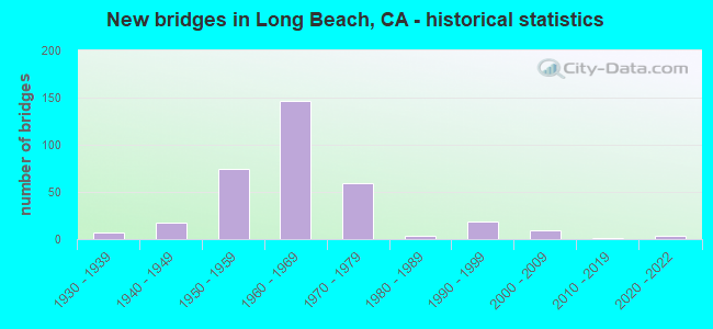
- New bridges - historical statistics
- 71930-1939
- 171940-1949
- 751950-1959
- 1461960-1969
- 591970-1979
- 41980-1989
- 191990-1999
- 92000-2009
- 12010-2019
- 42020-2022
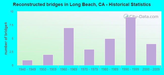
- Reconstructed bridges - Historical Statistics
- 11940-1949
- 21950-1959
- 71960-1969
- 31970-1979
- 51980-1989
- 91990-1999
- 42000-2009
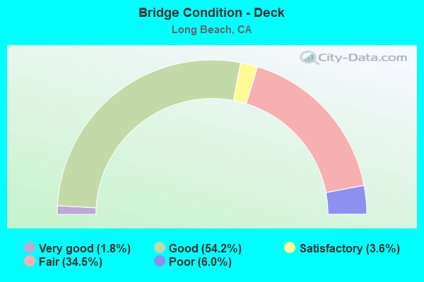
- Bridge Condition - Deck
- 1.8%Very good
- 54.2%Good
- 3.6%Satisfactory
- 34.5%Fair
- 6.0%Poor
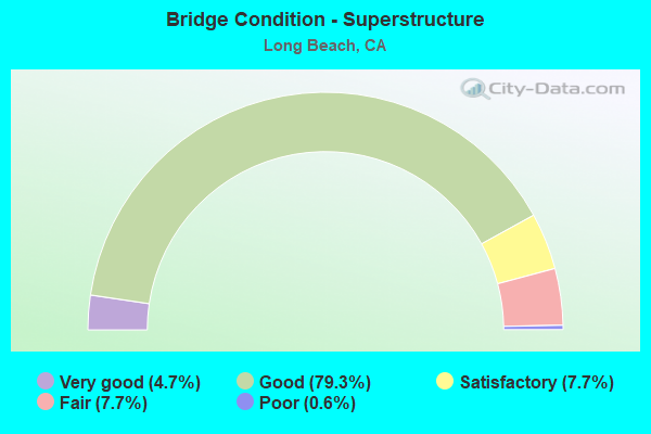
- Bridge Condition - Superstructure
- 4.7%Very good
- 79.3%Good
- 7.7%Satisfactory
- 7.7%Fair
- 0.6%Poor
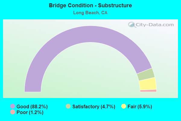
- Bridge Condition - Substructure
- 88.2%Good
- 4.7%Satisfactory
- 5.9%Fair
- 1.2%Poor
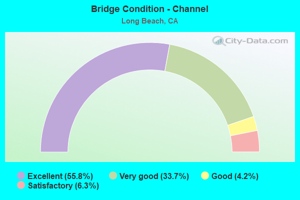
- Bridge Condition - Channel
- 55.8%Excellent
- 33.7%Very good
- 4.2%Good
- 6.3%Satisfactory
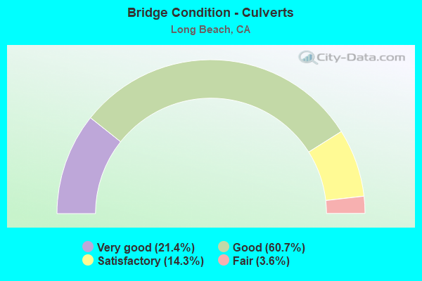
- Bridge Condition - Culverts
- 21.4%Very good
- 60.7%Good
- 14.3%Satisfactory
- 3.6%Fair
Find on map >> Show street view
Structure Number: 53 2241G, Location: 07-LA-091-R11.65-LBCH (Lat: 33.874736, Lng: -118.193875), Route carried "under" structure: Ramp Interstate 710, Year Built: 1974, Structure Length: 0. m, Average Daily Traffic: 65,000 (year 2015), Truck Traffic: 15%, Features Intersected: I 710, W91-S710,N710-E91
Minimum Vertical Clearance: 4.49m (14.73ft), Kilometerpoint: 12.930, Lanes on structure: 2, Lanes under structure: 2, Material/Design: Prestressed concrete continuous, Design/Construction: Stringer/Multi-beam, Length of Maximum Span: 31.4m (103.0ft)
Find on map >> Show street view
Structure Number: 53 2241G, Location: 07-LA-091-R11.65-LBCH (Lat: 33.874736, Lng: -118.193875), Route carried "under" structure: Ramp Interstate 710, Year Built: 1974, Structure Length: 0. m, Average Daily Traffic: 35,000 (year 2015), Truck Traffic: 18%, Features Intersected: I 710, W91-S710,N710-E91
Minimum Vertical Clearance: 6.52m (21.39ft), Kilometerpoint: 12.930, Lanes on structure: 2, Lanes under structure: 1, Material/Design: Prestressed concrete continuous, Design/Construction: Stringer/Multi-beam, Length of Maximum Span: 31.4m (103.0ft)
Find on map >> Show street view
Structure Number: 53 2241G, Location: 07-LA-091-R11.65-LBCH (Lat: 33.874736, Lng: -118.193875), Route carried "under" structure: Interstate 710, Year Built: 1974, Structure Length: 0. m, Average Daily Traffic: 229,000 (year 2017), Truck Traffic: 15%, Features Intersected: I 710, W91-S710,N710-E91
Minimum Vertical Clearance: 6.62m (21.72ft), Kilometerpoint: 12.930, Lanes on structure: 2, Lanes under structure: 6, Material/Design: Prestressed concrete continuous, Design/Construction: Stringer/Multi-beam, Length of Maximum Span: 31.4m (103.0ft)
Find on map >> Show street view
Structure Number: 53 2373, Location: 07-LA-091-R11.10-LBCH (Lat: 33.872383, Lng: -118.202522), Route carried "under" structure: City street , Year Built: 1974, Structure Length: 0. m, Average Daily Traffic: 13,000 (year 2015), Truck Traffic: 2%, Features Intersected: LONG BEACH BLVD, Facility Carried by Structure: STATE ROUTE 91
Minimum Vertical Clearance: 5.18m (16.99ft), Kilometerpoint: 0.000, Lanes on structure: 13, Lanes under structure: 6, Material/Design: Prestressed concrete, Design/Construction: Box Beam or Girders - Multiple, Length of Maximum Span: 61.3m (201.1ft)
Find on map >> Show street view
Structure Number: 53 2707, Location: 07-LA-405-6.98-LBCH (Lat: 33.822881, Lng: -118.199242), Route carried "under" structure: Ramp Interstate 405, Year Built: 1963, Structure Length: 0. m, Average Daily Traffic: 262,400 (year 2011), Truck Traffic: 5%, Features Intersected: S405-PACIFIC PL OFF RAMP, Facility Carried by Structure: PEDESTRIAN WALKWAY
Minimum Vertical Clearance: 4.90m (16.08ft), Kilometerpoint: 6.980, Lanes under structure: 2, Material/Design: Concrete continuous, Design/Construction: Box Beam or Girders - Multiple, Length of Maximum Span: 25.9m (85.0ft)
Find on map >> Show street view
Structure Number: 53 2713, Location: 07-LA-022-1.08-LBCH (Lat: 33.774517, Lng: -118.104244), Route carried "under" structure: State highway 22, Year Built: 1982, Structure Length: 0. m, Average Daily Traffic: 67,000 (year 2015), Truck Traffic: 2%, Features Intersected: STATE ROUTE 22, Facility Carried by Structure: PEDESTRIAN WALKWAY
Minimum Vertical Clearance: 5.31m (17.42ft), Kilometerpoint: 1.080, Lanes under structure: 5, Material/Design: Steel, Design/Construction: Truss - Thru, Length of Maximum Span: 49.4m (162.1ft)
Find on map >> Show street view
Structure Number: 53 2731, Location: 07-LA-710-10.32-LBCH (Lat: 33.839708, Lng: -118.207506), Route carried "under" structure: Interstate 710, Year Built: 1990, Structure Length: 0. m, Average Daily Traffic: 181,000 (year 2009), Truck Traffic: 15%, Features Intersected: INTERSTATE 710, Facility Carried by Structure: BLUE LINE LRT
Minimum Vertical Clearance: 7.62m (25.00ft), Kilometerpoint: 10.320, Lanes under structure: 8, Material/Design: Prestressed concrete continuous, Design/Construction: Box Beam or Girders - Multiple, Length of Maximum Span: 48.8m (160.1ft)
Find on map >> Show street view
Structure Number: 53 2780F, Location: 07-LA-405-7.79-LBCH (Lat: 33.825828, Lng: -118.211103), Route carried "under" structure: Ramp Interstate 710, Year Built: 1997, Structure Length: 0. m, Average Daily Traffic: 2,000 (year 2011), Truck Traffic: 1%, Features Intersected: I 405 & CONNECTORS
Minimum Vertical Clearance: 6.14m (20.14ft), Kilometerpoint: 9.300, Lanes on structure: 2, Lanes under structure: 1, Material/Design: Prestressed concrete continuous, Design/Construction: Box Beam or Girders - Multiple, Length of Maximum Span: 56.1m (184.1ft)
Find on map >> Show street view
Structure Number: 53 2780F, Location: 07-LA-405-7.79-LBCH (Lat: 33.825828, Lng: -118.211103), Route carried "under" structure: Ramp Interstate 405, Year Built: 1997, Structure Length: 0. m, Average Daily Traffic: 2,000 (year 2011), Truck Traffic: 1%, Features Intersected: I 405 & CONNECTORS
Minimum Vertical Clearance: 5.86m (19.23ft), Kilometerpoint: 7.790, Lanes on structure: 2, Lanes under structure: 2, Material/Design: Prestressed concrete continuous, Design/Construction: Box Beam or Girders - Multiple, Length of Maximum Span: 56.1m (184.1ft)
Find on map >> Show street view
Structure Number: 53 2780F, Location: 07-LA-405-7.79-LBCH (Lat: 33.825828, Lng: -118.211103), Route carried "under" structure: Interstate 405, Year Built: 1997, Structure Length: 0. m, Average Daily Traffic: 283,000 (year 2011), Truck Traffic: 5%, Features Intersected: I 405 & CONNECTORS
Minimum Vertical Clearance: 5.96m (19.55ft), Kilometerpoint: 7.790, Lanes on structure: 2, Lanes under structure: 9, Material/Design: Prestressed concrete continuous, Design/Construction: Box Beam or Girders - Multiple, Length of Maximum Span: 56.1m (184.1ft)
Find on map >> Show street view
Structure Number: 53 2780F, Location: 07-LA-405-7.79-LBCH (Lat: 33.825828, Lng: -118.211103), Route carried "under" structure: Ramp Interstate 405, Year Built: 1997, Structure Length: 0. m, Average Daily Traffic: 2,000 (year 2011), Truck Traffic: 1%, Features Intersected: I 405 & CONNECTORS
Minimum Vertical Clearance: 6.85m (22.47ft), Kilometerpoint: 7.790, Lanes on structure: 2, Lanes under structure: 1, Material/Design: Prestressed concrete continuous, Design/Construction: Box Beam or Girders - Multiple, Length of Maximum Span: 56.1m (184.1ft)
Find on map >> Show street view
Structure Number: 53 2784K, Location: 07-LA-405-6.50-LBCH (Lat: 33.818814, Lng: -118.191389), Route carried "under" structure: City street , Year Built: 1994, Structure Length: 0. m, Average Daily Traffic: 11,200 (year 2011), Truck Traffic: 5%, Features Intersected: WARDLOW ROAD, Facility Carried by Structure: INTERSTATE 405 OFF
Minimum Vertical Clearance: 4.70m (15.42ft), Kilometerpoint: 0.000, Lanes on structure: 2, Lanes under structure: 4, Material/Design: Concrete continuous, Design/Construction: Stringer/Multi-beam, Length of Maximum Span: 25.6m (84.0ft)
Find on map >> Show street view
Structure Number: 53 2785S, Location: 07-LA-710-5.98-LBCH (Lat: 33.776097, Lng: -118.206839), Route carried "under" structure: State highway 710, Year Built: 1994, Structure Length: 0. m, Average Daily Traffic: 60,000 (year 2017), Truck Traffic: 32%, Features Intersected: UP RR, I 710, PICO, 7TH, Facility Carried by Structure: PICO AV ON-RAMP OH
Minimum Vertical Clearance: 6.00m (19.69ft), Kilometerpoint: 5.980, Lanes on structure: 2, Lanes under structure: 6, Material/Design: Prestressed concrete continuous, Design/Construction: Box Beam or Girders - Multiple, Length of Maximum Span: 52.4m (171.9ft)
Find on map >> Show street view
Structure Number: 53 2810K, Location: 07-LA-405-7.71-LBCH (Lat: 33.825978, Lng: -118.209439), Route carried "under" structure: Ramp Interstate 405, Year Built: 2001, Structure Length: 0. m, Average Daily Traffic: 2,000 (year 2013), Truck Traffic: 1%, Features Intersected: S405-S710 RAMP
Minimum Vertical Clearance: 5.15m (16.90ft), Kilometerpoint: 7.710, Lanes on structure: 1, Lanes under structure: 1, Material/Design: Prestressed concrete, Design/Construction: Box Beam or Girders - Single/Spread, Length of Maximum Span: 40.0m (131.2ft)
Find on map >> Show street view
Structure Number: 53 2883S, Location: 07-LA-605-R1.63-LBCH (Lat: 33.830494, Lng: -118.082797), Route carried "under" structure: Ramp Interstate 605, Year Built: 2001, Structure Length: 0. m, Average Daily Traffic: 1,000 (year 2009), Truck Traffic: 3%, Features Intersected: N605-CARSON ST OFF-RAMP
Minimum Vertical Clearance: 5.43m (17.81ft), Kilometerpoint: 1.630, Lanes on structure: 2, Lanes under structure: 2, Material/Design: Concrete continuous, Design/Construction: Box Beam or Girders - Multiple, Length of Maximum Span: 29.9m (98.1ft)
Find on map >> Show street view
Structure Number: 53 3, Location: 07-LA-710-3.60 (Lat: 33.764842, Lng: -118.221269), Route carried "under" structure: County highway , Year Built: 2020, Structure Length: 0. m, Average Daily Traffic: 5,000 (year 2015), Truck Traffic: 40%, Features Intersected: LONG BEACH/TERMINAL ISL, Facility Carried by Structure: ROUTE 710
Minimum Vertical Clearance: 8.00m (26.25ft), Kilometerpoint: 0.000, Lanes on structure: 6, Lanes under structure: 2, Material/Design: Steel, Design/Construction: Stayed Girder, Length of Maximum Span: 304.9m (1,000.3ft)
Find on map >> Show street view
Structure Number: 53 3, Location: 07-LA-710-3.60 (Lat: 33.764842, Lng: -118.221269), Route carried "under" structure: County highway , Year Built: 2020, Structure Length: 0. m, Average Daily Traffic: 22,500 (year 2015), Truck Traffic: 2%, Features Intersected: LONG BEACH/TERMINAL ISL, Facility Carried by Structure: ROUTE 710
Minimum Vertical Clearance: 7.00m (22.97ft), Kilometerpoint: 0.000, Lanes on structure: 6, Lanes under structure: 6, Material/Design: Steel, Design/Construction: Stayed Girder, Length of Maximum Span: 304.9m (1,000.3ft)
Find on map >> Show street view
Structure Number: 53 3, Location: 07-LA-710-3.60 (Lat: 33.764842, Lng: -118.221269), Route carried "under" structure: County highway , Year Built: 2020, Structure Length: 0. m, Average Daily Traffic: 5,000 (year 2015), Truck Traffic: 40%, Features Intersected: LONG BEACH/TERMINAL ISL, Facility Carried by Structure: ROUTE 710
Minimum Vertical Clearance: 8.00m (26.25ft), Kilometerpoint: 0.000, Lanes on structure: 6, Lanes under structure: 2, Material/Design: Steel, Design/Construction: Stayed Girder, Length of Maximum Span: 304.9m (1,000.3ft)
Find on map >> Show street view
Structure Number: 53C0018, Location: 0.1MI E/O I-710 FWY (Lat: 33.782558, Lng: -118.206431), Route carried "under" structure: City street , Year Built: 1952, Structure Length: 0. m, Average Daily Traffic: 35,638 (year 2012), Truck Traffic: 1%, Features Intersected: LA RIV / DEFOREST AVE, Facility Carried by Structure: ANAHEIM ST
Minimum Vertical Clearance: 4.57m (14.99ft), Kilometerpoint: 0.000, Lanes on structure: 6, Lanes under structure: 2, Material/Design: Steel, Design/Construction: Stringer/Multi-beam, Length of Maximum Span: 34.7m (113.8ft)
Find on map >> Show street view
Structure Number: 53C0209, Location: 0.3MI W/O SR-1 HWY (Lat: 33.756283, Lng: -118.117758), Route carried "under" structure: City street , Year Built: 1955, Structure Length: 0. m, Average Daily Traffic: 7,925 (year 2012), Truck Traffic: 2%, Features Intersected: MARINE STAD / APPIAN, Facility Carried by Structure: 2ND ST
Minimum Vertical Clearance: 6.10m (20.01ft), Kilometerpoint: 0.000, Lanes on structure: 6, Lanes under structure: 2, Material/Design: Steel, Design/Construction: Stringer/Multi-beam, Length of Maximum Span: 38.1m (125.0ft)
Find on map >> Show street view
Structure Number: 53C0404, Location: 0.5MI E/O LAKEWOOD BLVD (Lat: 33.832206, Lng: -118.136678), Route carried "under" structure: City street L031, Year Built: 1956, Structure Length: 0. m, Average Daily Traffic: 31,058 (year 2012), Truck Traffic: 2%, Features Intersected: CARSON ST, Facility Carried by Structure: LB CTY COLLEGE POC
Minimum Vertical Clearance: 4.55m (14.93ft), Kilometerpoint: 0.000, Lanes under structure: 4, Material/Design: Steel, Design/Construction: Girder and Floorbeam System, Length of Maximum Span: 36.8m (120.7ft)
Find on map >> Show street view
Structure Number: 53C059, Location: 0.8MI W/O I-710 FWY (Lat: 33.804231, Lng: -118.221417), Route carried "under" structure: City street , Year Built: 1932, Structure Length: 0. m, Average Daily Traffic: 21,836 (year 2012), Truck Traffic: 40%, Features Intersected: WILLOW ST, Facility Carried by Structure: UNION PACIFIC RR
Minimum Vertical Clearance: 4.57m (14.99ft), Kilometerpoint: 0.000, Lanes under structure: 5, Material/Design: Steel, Design/Construction: Truss - Thru, Length of Maximum Span: 32.3m (106.0ft)
Find on map >> Show street view
Structure Number: 53C0593, Location: 0.1MI N/O DEL AMO BLVD (Lat: 33.846378, Lng: -118.185086), Route carried "under" structure: City street , Year Built: 1932, Structure Length: 0. m, Average Daily Traffic: 23,108 (year 2012), Truck Traffic: 1%, Features Intersected: ATLANTIC AVE UP, Facility Carried by Structure: UNION PACIFIC R R
Minimum Vertical Clearance: 4.28m (14.04ft), Kilometerpoint: 0.000, Lanes under structure: 4, Material/Design: Steel, Design/Construction: Girder and Floorbeam System, Length of Maximum Span: 29.9m (98.1ft)
Find on map >> Show street view
Structure Number: 53C0594, Location: 0.2MI S/O DEL AMO BLVD (Lat: 33.843669, Lng: -118.192894), Route carried "under" structure: City street , Year Built: 1932, Structure Length: 0. m, Average Daily Traffic: 22,048 (year 2012), Truck Traffic: 2%, Features Intersected: LONG BEACH BLVD UP, Facility Carried by Structure: UNION PACIFIC RR
Minimum Vertical Clearance: 4.75m (15.58ft), Kilometerpoint: 0.000, Lanes under structure: 4, Material/Design: Steel, Design/Construction: Truss - Thru, Length of Maximum Span: 32.0m (105.0ft)
Find on map >> Show street view
Structure Number: 53C064, Location: 0.4MI W/O PACIFIC AVE (Lat: 33.774025, Lng: -118.200697), Route carried "under" structure: City street , Year Built: 1958, Structure Length: 0. m, Average Daily Traffic: 17,384 (year 2012), Truck Traffic: 2%, Features Intersected: 6TH ST, Facility Carried by Structure: MAINE AVE POC
Minimum Vertical Clearance: 4.57m (14.99ft), Kilometerpoint: 0.000, Lanes under structure: 3, Material/Design: Prestressed concrete, Design/Construction: Box Beam or Girders - Multiple, Length of Maximum Span: 23.8m (78.1ft)
Find on map >> Show street view
Structure Number: 53C0658, Location: 0.4MI W/O MAGNOLIA AVE (Lat: 33.775183, Lng: -118.200697), Route carried "under" structure: City street , Year Built: 1958, Structure Length: 0. m, Average Daily Traffic: 16,324 (year 2012), Truck Traffic: 1%, Features Intersected: 7TH ST, Facility Carried by Structure: MAINE AVE POC
Minimum Vertical Clearance: 4.65m (15.26ft), Kilometerpoint: 0.000, Lanes under structure: 3, Material/Design: Prestressed concrete, Design/Construction: Box Beam or Girders - Multiple, Length of Maximum Span: 21.3m (69.9ft)
Find on map >> Show street view
Structure Number: 53C0724, Location: 0.5MI S/O DEL AMO BLVD (Lat: 33.840497, Lng: -118.134003), Route carried "under" structure: City street , Year Built: 1958, Structure Length: 0. m, Average Daily Traffic: 23,002 (year 2012), Truck Traffic: 1%, Features Intersected: CLARK AVE, Facility Carried by Structure: MARK TWAIN SCH POC
Minimum Vertical Clearance: 4.47m (14.67ft), Kilometerpoint: 0.000, Lanes under structure: 4, Material/Design: Prestressed concrete, Design/Construction: Stringer/Multi-beam, Length of Maximum Span: 25.9m (85.0ft)
Find on map >> Show street view
Structure Number: 53C0739, Location: 0.2MI W/O ATLANTIC AVE (Lat: 33.845553, Lng: -118.187483), Route carried "under" structure: City street , Year Built: 1950, Structure Length: 0. m, Average Daily Traffic: 33,708 (year 2012), Truck Traffic: 2%, Features Intersected: DEL AMO BLVD UP, Facility Carried by Structure: UPRR
Minimum Vertical Clearance: 5.74m (18.83ft), Kilometerpoint: 0.000, Lanes under structure: 6, Material/Design: Steel, Design/Construction: Girder and Floorbeam System, Length of Maximum Span: 20.1m (65.9ft)
Find on map >> Show street view
Structure Number: 53C0817, Location: 0.1MI S/O OCEAN BLVD (Lat: 33.765186, Lng: -118.201750), Route carried "under" structure: City street L052, Year Built: 1970, Structure Length: 0. m, Average Daily Traffic: 6,798 (year 2012), Truck Traffic: 1%, Features Intersected: SHORELINE DR, Facility Carried by Structure: GOLDEN SHORE BLVD
Minimum Vertical Clearance: 4.98m (16.34ft), Kilometerpoint: 0.000, Lanes on structure: 3, Lanes under structure: 5, Material/Design: Concrete continuous, Design/Construction: Box Beam or Girders - Multiple, Length of Maximum Span: 22.6m (74.1ft)
Find on map >> Show street view
Structure Number: 53C0823, Location: 1.0MI S/O OCEAN BLVD (Lat: 33.762744, Lng: -118.205836), Route carried "under" structure: City street , Year Built: 1970, Structure Length: 0. m, Average Daily Traffic: 1,020 (year 2012), Truck Traffic: 70%, Features Intersected: HARBOR SCENIC DR NB RAMP, Facility Carried by Structure: HARBOR SCENIC DR S
Minimum Vertical Clearance: 4.57m (14.99ft), Kilometerpoint: 0.000, Lanes on structure: 3, Lanes under structure: 1, Material/Design: Concrete, Design/Construction: Box Beam or Girders - Single/Spread, Length of Maximum Span: 19.5m (64.0ft)
Find on map >> Show street view
Structure Number: 53C0832, Location: 0.3MI W/O MAGNOLIA (Lat: 33.769386, Lng: -118.203289), Route carried "under" structure: City street L052, Year Built: 1958, Structure Length: 0. m, Average Daily Traffic: 6,798 (year 2012), Truck Traffic: 1%, Features Intersected: SHORELINE DR, Facility Carried by Structure: BROADWAY
Minimum Vertical Clearance: 4.72m (15.49ft), Kilometerpoint: 0.000, Lanes on structure: 1, Lanes under structure: 2, Material/Design: Prestressed concrete, Design/Construction: Box Beam or Girders - Multiple, Length of Maximum Span: 16.5m (54.1ft)
Find on map >> Show street view
Structure Number: 53C0885, Location: 0.1MI W/O I-710 FWY (Lat: 33.782533, Lng: -118.207906), Route carried "under" structure: City street , Year Built: 1954, Structure Length: 0. m, Average Daily Traffic: 131,000 (year 2013), Truck Traffic: 14%, Features Intersected: LONG BEACH FREEWAY, Facility Carried by Structure: ANAHEIM ST
Minimum Vertical Clearance: 4.57m (14.99ft), Kilometerpoint: 6.389, Lanes on structure: 7, Lanes under structure: 10, Material/Design: Steel continuous, Design/Construction: Stringer/Multi-beam, Length of Maximum Span: 24.1m (79.1ft)
Find on map >> Show street view
Structure Number: 53C0889, Location: 0.1MI E/O HARBOR PLZ (Lat: 33.755244, Lng: -118.200047), Route carried "under" structure: City street L051, Year Built: 1967, Structure Length: 0. m, Average Daily Traffic: 9,270 (year 2012), Truck Traffic: 60%, Features Intersected: HARBOR SCENIC DR, Facility Carried by Structure: QUEENS WAY NB
Minimum Vertical Clearance: 4.72m (15.49ft), Kilometerpoint: 0.000, Lanes on structure: 2, Lanes under structure: 9, Material/Design: Concrete continuous, Design/Construction: Box Beam or Girders - Single/Spread, Length of Maximum Span: 33.5m (109.9ft)
Find on map >> Show street view
Structure Number: 53C0890L, Location: 0.6MI S/O OCEAN BLVD (Lat: 33.755792, Lng: -118.200494), Route carried "under" structure: City street L051, Year Built: 1967, Structure Length: 0. m, Average Daily Traffic: 4,590 (year 2012), Truck Traffic: 60%, Features Intersected: HARBOR SCENIC DR, Facility Carried by Structure: QUEENS WAY-SBND
Minimum Vertical Clearance: 4.72m (15.49ft), Kilometerpoint: 0.000, Lanes on structure: 2, Lanes under structure: 6, Material/Design: Concrete continuous, Design/Construction: Box Beam or Girders - Single/Spread, Length of Maximum Span: 35.1m (115.2ft)
Find on map >> Show street view
Structure Number: 53C0890R, Location: 0.6MI S/O OCEAN BLVD (Lat: 33.756008, Lng: -118.200042), Route carried "under" structure: City street L051, Year Built: 1967, Structure Length: 0. m, Average Daily Traffic: 2,346 (year 2012), Truck Traffic: 60%, Features Intersected: HARBOR SCENIC DR, Facility Carried by Structure: QUEENS WAY-SBND
Minimum Vertical Clearance: 4.72m (15.49ft), Kilometerpoint: 0.000, Lanes on structure: 2, Lanes under structure: 3, Material/Design: Concrete continuous, Design/Construction: Box Beam or Girders - Single/Spread, Length of Maximum Span: 35.1m (115.2ft)
Find on map >> Show street view
Structure Number: 53C0892L, Location: 0.1MI S/O OCEAN BLVD (Lat: 33.765169, Lng: -118.198056), Route carried "under" structure: City street , Year Built: 1967, Structure Length: 0. m, Average Daily Traffic: 15,244 (year 2012), Truck Traffic: 1%, Features Intersected: SHORELN DR / SEASIDE P, Facility Carried by Structure: QUEENS WAY SBND
Minimum Vertical Clearance: 4.42m (14.50ft), Kilometerpoint: 0.000, Lanes on structure: 3, Lanes under structure: 8, Material/Design: Concrete, Design/Construction: Box Beam or Girders - Single/Spread, Length of Maximum Span: 30.8m (101.0ft)
Find on map >> Show street view
Structure Number: 53C0892R, Location: 0.1MI S/O OCEAN BLVD (Lat: 33.765108, Lng: -118.197786), Route carried "under" structure: City street , Year Built: 1967, Structure Length: 0. m, Average Daily Traffic: 15,244 (year 2012), Truck Traffic: 1%, Features Intersected: SHORELN DR / SEASIDE P, Facility Carried by Structure: QUEENS WAY NBND
Minimum Vertical Clearance: 4.42m (14.50ft), Kilometerpoint: 0.000, Lanes on structure: 3, Lanes under structure: 10, Material/Design: Concrete, Design/Construction: Box Beam or Girders - Single/Spread, Length of Maximum Span: 30.8m (101.0ft)
Find on map >> Show street view
Structure Number: 53C0903, Location: 0.2MI N/O BROADWAY (Lat: 33.774914, Lng: -118.203131), Route carried "under" structure: Ramp City street L053, Year Built: 1961, Structure Length: 0. m, Average Daily Traffic: 13,081 (year 2012), Features Intersected: 7TH ST W ON RAMP, Facility Carried by Structure: I-710 FWY
Minimum Vertical Clearance: 4.57m (14.99ft), Kilometerpoint: 0.000, Lanes on structure: 4, Lanes under structure: 1, Material/Design: Concrete, Design/Construction: Slab, Length of Maximum Span: 12.9m (42.3ft)
Find on map >> Show street view
Structure Number: 53C0927, Location: 0.1MI E/O PICO AVE (Lat: 33.766986, Lng: -118.207989), Route carried "under" structure: City street , Year Built: 1959, Structure Length: 0. m, Average Daily Traffic: 10,300 (year 2012), Truck Traffic: 70%, Features Intersected: RR,HRB SC DR,LA RV,SHLND, Facility Carried by Structure: OCEAN BLVD
Minimum Vertical Clearance: 4.57m (14.99ft), Kilometerpoint: 0.000, Lanes on structure: 6, Lanes under structure: 4, Material/Design: Steel, Design/Construction: Stringer/Multi-beam, Length of Maximum Span: 44.5m (146.0ft)
Find on map >> Show street view
Structure Number: 53C0927, Location: 0.1MI E/O PICO AVE (Lat: 33.766986, Lng: -118.207989), Route carried "under" structure: City street , Year Built: 1959, Structure Length: 0. m, Average Daily Traffic: 15,200 (year 2012), Truck Traffic: 1%, Features Intersected: RR,HRB SC DR,LA RV,SHLND, Facility Carried by Structure: OCEAN BLVD
Minimum Vertical Clearance: 4.57m (14.99ft), Kilometerpoint: 0.000, Lanes on structure: 6, Lanes under structure: 5, Material/Design: Steel, Design/Construction: Stringer/Multi-beam, Length of Maximum Span: 44.5m (146.0ft)
Find on map >> Show street view
Structure Number: 53C0927, Location: 0.1MI E/O PICO AVE (Lat: 33.766986, Lng: -118.207989), Route carried "under" structure: City street , Year Built: 1959, Structure Length: 0. m, Average Daily Traffic: 2,000 (year 2013), Truck Traffic: 40%, Features Intersected: RR,HRB SC DR,LA RV,SHLND, Facility Carried by Structure: OCEAN BLVD
Minimum Vertical Clearance: 4.56m (14.96ft), Kilometerpoint: 0.000, Lanes on structure: 6, Lanes under structure: 2, Material/Design: Steel, Design/Construction: Stringer/Multi-beam, Length of Maximum Span: 44.5m (146.0ft)
Find on map >> Show street view
Structure Number: 53C0927, Location: 0.1MI E/O PICO AVE (Lat: 33.766986, Lng: -118.207989), Route carried "under" structure: City street , Year Built: 1959, Structure Length: 0. m, Average Daily Traffic: 10,300 (year 2012), Truck Traffic: 70%, Features Intersected: RR,HRB SC DR,LA RV,SHLND, Facility Carried by Structure: OCEAN BLVD
Minimum Vertical Clearance: 4.57m (14.99ft), Kilometerpoint: 0.000, Lanes on structure: 6, Lanes under structure: 4, Material/Design: Steel, Design/Construction: Stringer/Multi-beam, Length of Maximum Span: 44.5m (146.0ft)
Find on map >> Show street view
Structure Number: 53C093, Location: 0.5MI E/O SANTA FE AVE (Lat: 33.779000, Lng: -118.209236), Route carried "under" structure: ServiceCity street , Year Built: 1960, Structure Length: 0. m, Average Daily Traffic: 4,496 (year 2019), Truck Traffic: 70%, Features Intersected: 10ST RMP,10ST,HRB SC DR, Facility Carried by Structure: 9TH ST
Minimum Vertical Clearance: 4.70m (15.42ft), Kilometerpoint: 0.000, Lanes on structure: 1, Lanes under structure: 2, Material/Design: Steel, Design/Construction: Stringer/Multi-beam, Length of Maximum Span: 35.1m (115.2ft)
Find on map >> Show street view
Structure Number: 53C0931, Location: 0.3MI S/O ANAHEIM ST (Lat: 33.777936, Lng: -118.206411), Route carried "under" structure: ServiceCity street , Year Built: 1957, Structure Length: 0. m, Average Daily Traffic: 111,350 (year 2012), Truck Traffic: 20%, Features Intersected: 710 FWY,HB SC DR,10TH ST, Facility Carried by Structure: 10TH ST OFF RAMP
Minimum Vertical Clearance: 4.60m (15.09ft), Kilometerpoint: 0.000, Lanes on structure: 2, Lanes under structure: 3, Material/Design: Steel, Design/Construction: Stringer/Multi-beam, Length of Maximum Span: 38.7m (127.0ft)
Find on map >> Show street view
Structure Number: 53C0931, Location: 0.3MI S/O ANAHEIM ST (Lat: 33.777936, Lng: -118.206411), Route carried "under" structure: ServiceCity street , Year Built: 1957, Structure Length: 0. m, Average Daily Traffic: 22,270 (year 2015), Truck Traffic: 25%, Features Intersected: 710 FWY,HB SC DR,10TH ST, Facility Carried by Structure: 10TH ST OFF RAMP
Minimum Vertical Clearance: 4.60m (15.09ft), Kilometerpoint: 6.039, Lanes on structure: 2, Lanes under structure: 7, Material/Design: Steel, Design/Construction: Stringer/Multi-beam, Length of Maximum Span: 38.7m (127.0ft)
Find on map >> Show street view
Structure Number: 53C0932, Location: 0.2MI S/O ANAHEIM ST (Lat: 33.776381, Lng: -118.204114), Route carried "under" structure: City street , Year Built: 1959, Structure Length: 0. m, Average Daily Traffic: 12,536 (year 2012), Truck Traffic: 55%, Features Intersected: LA RIV,UP,HARBOR SCENIC, Facility Carried by Structure: W SHORELINE DRIVE
Minimum Vertical Clearance: 4.80m (15.75ft), Kilometerpoint: 0.000, Lanes on structure: 6, Lanes under structure: 3, Material/Design: Steel, Design/Construction: Stringer/Multi-beam, Length of Maximum Span: 39.6m (129.9ft)
Find on map >> Show street view
Structure Number: 53C1407, Location: 0.2MI N/O DEL AMO BLVD (Lat: 33.849086, Lng: -118.177217), Route carried "under" structure: City street , Year Built: 1932, Structure Length: 0. m, Average Daily Traffic: 10,300 (year 2012), Truck Traffic: 1%, Features Intersected: ORANGE AVE, Facility Carried by Structure: UPRR
Minimum Vertical Clearance: 4.36m (14.30ft), Kilometerpoint: 0.000, Lanes under structure: 4, Material/Design: Steel, Design/Construction: Girder and Floorbeam System, Length of Maximum Span: 24.7m (81.0ft)
Find on map >> Show street view
Structure Number: 53C1804, Location: 300FT E/O PINE AVE (Lat: 33.762397, Lng: -118.191711), Route carried "under" structure: City street , Year Built: 1983, Structure Length: 0. m, Average Daily Traffic: 6,798 (year 2012), Truck Traffic: 1%, Features Intersected: SHORELINE DR, Facility Carried by Structure: LBCH PROMENADE POC
Minimum Vertical Clearance: 4.57m (14.99ft), Kilometerpoint: 0.000, Lanes under structure: 9, Material/Design: Concrete, Design/Construction: Tee Beam, Length of Maximum Span: 27.4m (89.9ft)
Find on map >> Show street view
Structure Number: 53C2071, Location: 0.7 MILE EO NAVY WAY (Lat: 33.757500, Lng: -118.240556), Route carried "under" structure: ServiceCity street L094, Year Built: 2005, Structure Length: 0. m, Average Daily Traffic: 20,000 (year 2017), Truck Traffic: 21%, Features Intersected: Pier S Avenue, Facility Carried by Structure: Seaside Freeway
Minimum Vertical Clearance: 5.50m (18.04ft), Kilometerpoint: 0.000, Lanes on structure: 4, Lanes under structure: 4, Material/Design: Prestressed concrete, Design/Construction: Box Beam or Girders - Multiple, Length of Maximum Span: 42.9m (140.7ft)
Find on map >> Show street view
Structure Number: 53C2072, Location: AT SR-47 HWY (Lat: 33.758269, Lng: -118.238697), Route carried "under" structure: City street , Year Built: 2005, Structure Length: 0. m, Average Daily Traffic: 15,200 (year 2014), Truck Traffic: 38%, Features Intersected: TERMINAL ISLAND FWY, Facility Carried by Structure: OCEAN AVE
Minimum Vertical Clearance: 6.61m (21.69ft), Kilometerpoint: 0.000, Lanes on structure: 4, Lanes under structure: 5, Material/Design: Prestressed concrete, Design/Construction: Box Beam or Girders - Single/Spread, Length of Maximum Span: 45.5m (149.3ft)
Find on map >> Show street view
Structure Number: 53C216, Location: 0.1MI S/O SHORELINE DR (Lat: 33.763228, Lng: -118.197642), Route carried "under" structure: City street , Year Built: 1998, Structure Length: 0. m, Average Daily Traffic: 3,060 (year 2012), Truck Traffic: 1%, Features Intersected: QUEENS WAY S ON-RAMP, Facility Carried by Structure: QUEENS WAY NB
Minimum Vertical Clearance: 5.27m (17.29ft), Kilometerpoint: 0.000, Lanes on structure: 2, Lanes under structure: 1, Material/Design: Concrete continuous, Design/Construction: Box Beam or Girders - Single/Spread, Length of Maximum Span: 31.9m (104.7ft)
Find on map >> Show street view
Structure Number: 53C2162, Location: 0.4MI S/O HARBOR PLZ (Lat: 33.744342, Lng: -118.189808), Route carried "under" structure: City street , Year Built: 1997, Structure Length: 0. m, Average Daily Traffic: 12,536 (year 2012), Truck Traffic: 55%, Features Intersected: S HARBOR SCENIC DR, Facility Carried by Structure: PIER J AVE E
Minimum Vertical Clearance: 5.56m (18.24ft), Kilometerpoint: 0.000, Lanes on structure: 5, Lanes under structure: 2, Material/Design: Concrete, Design/Construction: Box Beam or Girders - Single/Spread, Length of Maximum Span: 49.2m (161.4ft)
Find on map >> Show street view
Structure Number: 53C2221, Location: 0.1MI E/O PINE AVE (Lat: 33.763719, Lng: -118.195011), Route carried "under" structure: City street , Year Built: 2003, Structure Length: 0. m, Average Daily Traffic: 15,244 (year 2012), Truck Traffic: 1%, Features Intersected: SHORELINE DR, Facility Carried by Structure: THE PIKE POC
Minimum Vertical Clearance: 4.97m (16.31ft), Kilometerpoint: 0.000, Lanes under structure: 8, Material/Design: Steel, Design/Construction: Girder and Floorbeam System, Length of Maximum Span: 42.5m (139.4ft)