Bridge Statistics for Loraine, Texas (TX)
Condition, Traffic, Stress, Structural Evaluation, Project Costs
- National Bridge Inventory (NBI) Statistics
- 42Number of bridges
- 361ft / 110mTotal length
- $407,000Total costs
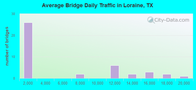
- 207,562Total average daily traffic
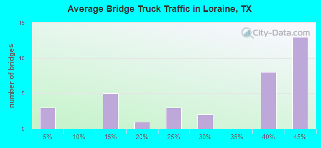
- 84,943Total average daily truck traffic
- National Bridge Inventory (NBI) Registered Bridges for Loraine
- No street view available for this location
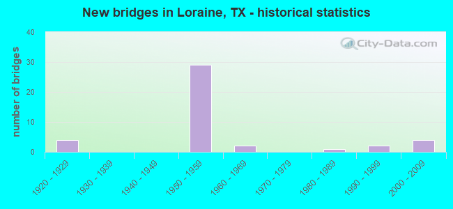
- New bridges - historical statistics
- 41920-1929
- 291950-1959
- 21960-1969
- 11980-1989
- 21990-1999
- 42000-2009
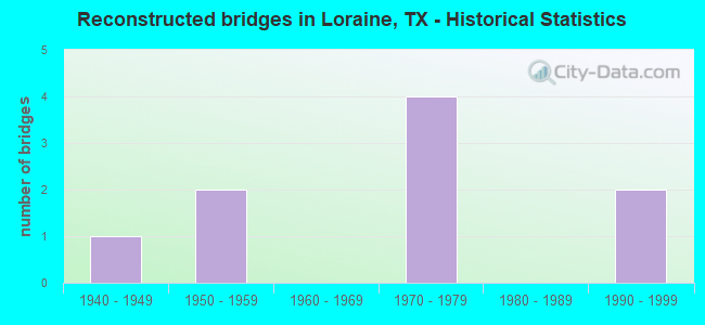
- Reconstructed bridges - Historical Statistics
- 11940-1949
- 21950-1959
- 01960-1969
- 41970-1979
- 01980-1989
- 21990-1999
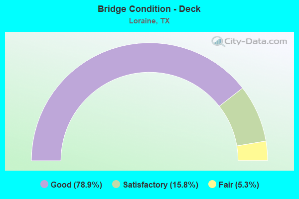
- Bridge Condition - Deck
- 78.9%Good
- 15.8%Satisfactory
- 5.3%Fair
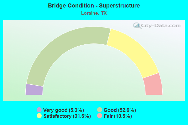
- Bridge Condition - Superstructure
- 5.3%Very good
- 52.6%Good
- 31.6%Satisfactory
- 10.5%Fair
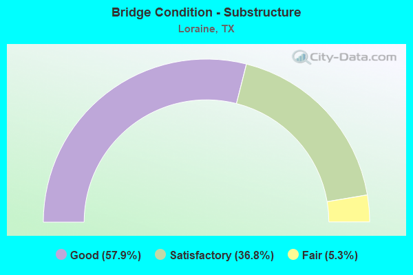
- Bridge Condition - Substructure
- 57.9%Good
- 36.8%Satisfactory
- 5.3%Fair
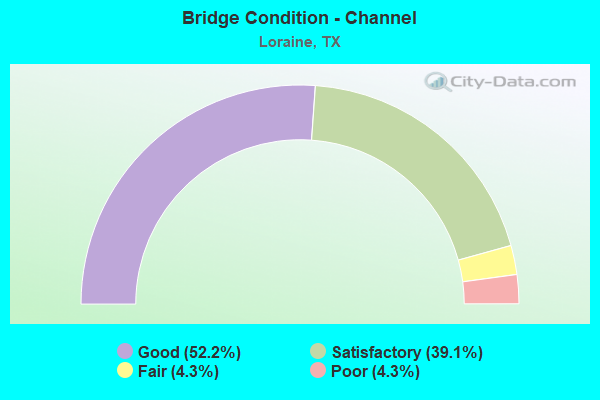
- Bridge Condition - Channel
- 52.2%Good
- 39.1%Satisfactory
- 4.3%Fair
- 4.3%Poor
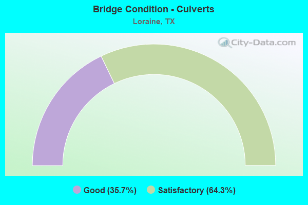
- Bridge Condition - Culverts
- 35.7%Good
- 64.3%Satisfactory
Find on map >> Show street view
Structure Number: 81680000507009, Location: 0.9 MI E OF HOWARD CO LN (Lat: 32.331100, Lng: -101.163225), Route carried "on" structure: Interstate 20, Year Built: 1928, Year Reconstructed: 1984, Status: Open, Structure Length: 1.34m (4.40ft), Average Daily Traffic: 18,494 (year 2020), Truck Traffic: 37%, Average Future Daily Traffic: 20,120 (year 2033), Design Load: H 15, Features Intersected: IATAN CREEK
Minimum Vertical Clearance: 30+ m (98+ ft), Kilometerpoint: 3.093, Lanes on structure: 8, Base Highway Network: Yes, Owner: State Highway Agency, Approaching Roadway Width: 37.8m (124.0ft), Material/Design: Concrete, Design/Construction: Culvert, Number Of Spans In Main Unit: 8, Length of Maximum Span: 2.4m (7.9ft)
Condition: Channel: Satisfactory, Culverts: Satisfactory, Operating Rating: 39.9 metric tons, Method Used To Determine Operating Rating: Load Factor (LF), Inventory Rating: 23.6 metric tons, Method Used To Determine Inventory Rating: Load Factor (LF), Structural Evaluation: Somewhat better than minimum adequacy, Waterway Adequacy: Superior to present desirable criteria, Approach Roadway Alignment: Equal to present desirable criteria, Designated Inspection Frequency: Every 24 months, Inspection Date: May 2021
Find on map >> Show street view
Structure Number: 81680000601001, Location: 5.7 MI E OF SH 208(S) (Lat: 32.408969, Lng: -100.752208), Route carried "on" structure: Interstate 20, Year Built: 1929, Year Reconstructed: 1984, Status: Open, Structure Length: 1.68m (5.51ft), Average Daily Traffic: 14,470 (year 2013), Truck Traffic: 43%, Average Future Daily Traffic: 20,260 (year 2033), Design Load: H 15, Features Intersected: W FORK OF N CHAMPION CRK
Minimum Vertical Clearance: 30+ m (98+ ft), Kilometerpoint: 44.420, Lanes on structure: 4, Owner: State Highway Agency, Approaching Roadway Width: 24.4m (80.1ft), Skew: 20 degrees, Material/Design: Concrete, Design/Construction: Culvert, Number Of Spans In Main Unit: 5, Length of Maximum Span: 3.0m (9.8ft), Curb-To-Curb Width: 24.9m (81.7ft), Out-to-Out Width: 36.6m (120.1ft)
Condition: Channel: Good, Culverts: Satisfactory, Operating Rating: 39.9 metric tons, Method Used To Determine Operating Rating: Load Factor (LF), Inventory Rating: 23.6 metric tons, Method Used To Determine Inventory Rating: Load Factor (LF), Structural Evaluation: Somewhat better than minimum adequacy, Deck Geometry: Superior to present desirable criteria, Waterway Adequacy: Equal to present minimum criteria, Approach Roadway Alignment: Equal to present desirable criteria, Designated Inspection Frequency: Every 24 months, Inspection Date: May 2021, Deck Structure Type: Concrete Cast-file-Place, Wearing Surface/Protective System: Wearing Surface: Bituminous
Find on map >> Show street view
Structure Number: 81680000601002, Location: 5.8 MI E OF SH 208(S) (Lat: 32.409081, Lng: -100.750789), Route carried "on" structure: Interstate 20, Year Built: 1929, Year Reconstructed: 1947, Status: Open, Structure Length: 1.13m (3.71ft), Average Daily Traffic: 7,230 (year 2013), Truck Traffic: 43%, Average Future Daily Traffic: 10,130 (year 2033), Design Load: H 15, Features Intersected: NORTH CHAMPION CREEK
Minimum Vertical Clearance: 30+ m (98+ ft), Kilometerpoint: 44.556, Lanes on structure: 2, Owner: State Highway Agency, Approaching Roadway Width: 12.8m (42.0ft), Material/Design: Concrete, Design/Construction: Slab, Number Of Spans In Main Unit: 2, Length of Maximum Span: 5.5m (18.0ft), Curb-To-Curb Width: 13.4m (44.0ft), Out-to-Out Width: 14.0m (45.9ft)
Condition: Deck: Good, Superstructure: Good, Substructure: Satisfactory, Channel: Good, Operating Rating: 50.8 metric tons, Method Used To Determine Operating Rating: Load Factor (LF), Inventory Rating: 30.8 metric tons, Method Used To Determine Inventory Rating: Load Factor (LF), Structural Evaluation: Equal to present minimum criteria, Deck Geometry: Superior to present desirable criteria, Waterway Adequacy: Equal to present minimum criteria, Approach Roadway Alignment: Equal to present desirable criteria, Designated Inspection Frequency: Every 24 months, Inspection Date: May 2021, Deck Structure Type: Concrete Cast-file-Place, Wearing Surface/Protective System: Wearing Surface: Bituminous
Find on map >> Show street view
Structure Number: 81680000601003, Location: 5.9 MI E OF SH 208(S) (Lat: 32.409503, Lng: -100.749256), Route carried "on" structure: Interstate 20, Year Built: 1929, Year Reconstructed: 1984, Status: Open, Structure Length: 1.34m (4.40ft), Average Daily Traffic: 14,470 (year 2013), Truck Traffic: 43%, Average Future Daily Traffic: 20,260 (year 2033), Design Load: H 15, Features Intersected: E FORK OF N CHAMPION CRK
Minimum Vertical Clearance: 30+ m (98+ ft), Kilometerpoint: 44.709, Lanes on structure: 4, Owner: State Highway Agency, Approaching Roadway Width: 24.4m (80.1ft), Skew: 20 degrees, Material/Design: Concrete, Design/Construction: Culvert, Number Of Spans In Main Unit: 4, Length of Maximum Span: 3.0m (9.8ft), Curb-To-Curb Width: 24.4m (80.1ft), Out-to-Out Width: 36.0m (118.1ft)
Condition: Channel: Satisfactory, Culverts: Satisfactory, Operating Rating: 39.9 metric tons, Method Used To Determine Operating Rating: Load Factor (LF), Inventory Rating: 23.6 metric tons, Method Used To Determine Inventory Rating: Load Factor (LF), Structural Evaluation: Somewhat better than minimum adequacy, Deck Geometry: Superior to present desirable criteria, Waterway Adequacy: Superior to present desirable criteria, Approach Roadway Alignment: Equal to present desirable criteria, Designated Inspection Frequency: Every 24 months, Inspection Date: May 2021, Deck Structure Type: Concrete Cast-file-Place, Wearing Surface/Protective System: Wearing Surface: Bituminous
Find on map >> Show street view
Structure Number: 81680000601073, Location: 5.8 MI E OF SH 208(S) (Lat: 32.409322, Lng: -100.750850), Route carried "on" structure: Interstate 20, Year Built: 1956, Status: Open, Structure Length: 1.86m (6.10ft), Average Daily Traffic: 7,230 (year 2013), Truck Traffic: 43%, Average Future Daily Traffic: 10,130 (year 2033), Features Intersected: NORTH CHAMPION CREEK
Minimum Vertical Clearance: 30+ m (98+ ft), Kilometerpoint: 44.556, Lanes on structure: 2, Owner: State Highway Agency, Approaching Roadway Width: 11.6m (38.1ft), Material/Design: Concrete, Design/Construction: Stringer/Multi-beam, Number Of Spans In Main Unit: 2, Length of Maximum Span: 9.1m (29.9ft), Curb-To-Curb Width: 11.7m (38.4ft), Out-to-Out Width: 12.1m (39.7ft)
Condition: Deck: Satisfactory, Superstructure: Satisfactory, Substructure: Satisfactory, Channel: Good, Operating Rating: 68.0 metric tons, Method Used To Determine Operating Rating: Load Factor (LF), Inventory Rating: 40.8 metric tons, Method Used To Determine Inventory Rating: Load Factor (LF), Structural Evaluation: Equal to present minimum criteria, Deck Geometry: Equal to present minimum criteria, Waterway Adequacy: Equal to present minimum criteria, Approach Roadway Alignment: Equal to present desirable criteria, Designated Inspection Frequency: Every 24 months, Inspection Date: May 2021, Deck Structure Type: Concrete Cast-file-Place, Wearing Surface/Protective System: Wearing Surface: Bituminous
Find on map >> Show street view
Structure Number: 81680000601075, Location: 0.9 MI W OF FM 644 (S) (Lat: 32.413603, Lng: -100.728406), Route carried "on" structure: Interstate 20, Year Built: 1956, Year Reconstructed: 1958, Status: Open, Structure Length: 1.01m (3.31ft), Average Daily Traffic: 14,470 (year 2013), Truck Traffic: 43%, Average Future Daily Traffic: 20,260 (year 2033), Features Intersected: LORAINE DRAW
Minimum Vertical Clearance: 30+ m (98+ ft), Kilometerpoint: 46.722, Lanes on structure: 6, Owner: State Highway Agency, Approaching Roadway Width: 30.5m (100.1ft), Skew: 20 degrees, Material/Design: Concrete, Design/Construction: Culvert, Number Of Spans In Main Unit: 3, Length of Maximum Span: 3.0m (9.8ft)
Condition: Channel: Satisfactory, Culverts: Satisfactory, Operating Rating: 39.9 metric tons, Method Used To Determine Operating Rating: Load Factor (LF), Inventory Rating: 23.6 metric tons, Method Used To Determine Inventory Rating: Load Factor (LF), Structural Evaluation: Somewhat better than minimum adequacy, Waterway Adequacy: Superior to present desirable criteria, Approach Roadway Alignment: Equal to present desirable criteria, Designated Inspection Frequency: Every 24 months, Inspection Date: May 2021
Find on map >> Show street view
Structure Number: 81680000601077, Location: 0.05 MI E OF FM 644(S) (Lat: 32.414989, Lng: -100.712797), Route carried "on" structure: Interstate 20, Year Built: 1956, Year Reconstructed: 1958, Status: Open, Structure Length: 1.86m (6.10ft), Average Daily Traffic: 17,977 (year 2020), Truck Traffic: 43%, Average Future Daily Traffic: 18,710 (year 2033), Features Intersected: LORAINE DRAW
Minimum Vertical Clearance: 30+ m (98+ ft), Kilometerpoint: 48.224, Lanes on structure: 4, Owner: State Highway Agency, Approaching Roadway Width: 23.2m (76.1ft), Skew: 33 degrees, Material/Design: Concrete, Design/Construction: Culvert, Number Of Spans In Main Unit: 8, Length of Maximum Span: 1.8m (5.9ft)
Condition: Channel: Good, Culverts: Satisfactory, Operating Rating: 39.9 metric tons, Method Used To Determine Operating Rating: Load Factor (LF), Inventory Rating: 23.6 metric tons, Method Used To Determine Inventory Rating: Load Factor (LF), Structural Evaluation: Somewhat better than minimum adequacy, Waterway Adequacy: Superior to present desirable criteria, Approach Roadway Alignment: Equal to present desirable criteria, Length Of Structure Improvement: 1.86m (6.10ft), Designated Inspection Frequency: Every 24 months, Inspection Date: May 2021, Bridge Improvement Cost: $204,000, Roadway Improvement Cost: $102,000, Total Project Cost: $306,000
Find on map >> Show street view
Structure Number: 81680000601079, Location: 8.6 MI E OF SH 208(S) (Lat: 32.413758, Lng: -100.706392), Route carried "on" structure: Interstate 20, Year Built: 1956, Year Reconstructed: 1979, Status: Open, Structure Length: 23.10m (75.79ft), Average Daily Traffic: 17,977 (year 2020), Truck Traffic: 43%, Average Future Daily Traffic: 18,710 (year 2033), Design Load: HS 20, Features Intersected: UP RR & FM 644 (N)
Minimum Vertical Clearance: 30+ m (98+ ft), Kilometerpoint: 48.757, Lanes on structure: 4, Lanes under structure: 6, Owner: State Highway Agency, Approaching Roadway Width: 23.2m (76.1ft), Skew: 30 degrees, Material/Design: Steel continuous, Design/Construction: Stringer/Multi-beam, Number Of Spans In Main Unit: 18, Length of Maximum Span: 12.8m (42.0ft), Curb-To-Curb Width: 23.0m (75.5ft), Out-to-Out Width: 24.5m (80.4ft)
Condition: Deck: Fair, Superstructure: Fair, Substructure: Satisfactory, Operating Rating: 55.3 metric tons, Method Used To Determine Operating Rating: Load Factor (LF), Inventory Rating: 33.6 metric tons, Method Used To Determine Inventory Rating: Load Factor (LF), Structural Evaluation: Somewhat better than minimum adequacy, Deck Geometry: Superior to present desirable criteria, Underclear: High priority of corrective action, Approach Roadway Alignment: Equal to present desirable criteria, Designated Inspection Frequency: Every 24 months, Critical Feature Inspection Frequency: Every 24 months, Inspection Date: May 2021, Critical Feature Inspection Date: November 2020, Deck Structure Type: Concrete Cast-file-Place, Wearing Surface/Protective System: Wearing Surface: Bituminous
Find on map >> Show street view
Structure Number: 81680000601149, Location: 5.6 MI E OF SH 208(S) (Lat: 32.408294, Lng: -100.756064), Route carried "on" structure: County highway , Year Built: 1958, Status: Open, Structure Length: 9.30m (30.51ft), Average Daily Traffic: 100 (year 2020), Average Future Daily Traffic: 200 (year 2031), Design Load: H 20, Features Intersected: IH 20, Facility Carried by Structure: LUCAS RD (CR 265)
Minimum Vertical Clearance: 30+ m (98+ ft), Kilometerpoint: 6.437, Lanes on structure: 2, Lanes under structure: 8, Owner: State Highway Agency, Approaching Roadway Width: 9.1m (29.9ft), Material/Design: Prestressed concrete, Design/Construction: Stringer/Multi-beam, Number Of Spans In Main Unit: 4, Number Of Approach Spans: 2, Length of Maximum Span: 19.8m (65.0ft), Curb-To-Curb Width: 7.8m (25.6ft), Out-to-Out Width: 8.9m (29.2ft)
Condition: Deck: Good, Superstructure: Satisfactory, Substructure: Good, Operating Rating: 68.0 metric tons, Method Used To Determine Operating Rating: Load Factor (LF), Inventory Rating: 37.2 metric tons, Method Used To Determine Inventory Rating: Load Factor (LF), Structural Evaluation: Equal to present minimum criteria, Deck Geometry: Equal to present minimum criteria, Underclear: Equal to present minimum criteria, Approach Roadway Alignment: Equal to present desirable criteria, Designated Inspection Frequency: Every 24 months, Inspection Date: May 2021, Deck Structure Type: Concrete Cast-file-Place, Wearing Surface/Protective System: Wearing Surface: Bituminous
Find on map >> Show street view
Structure Number: 8168000060115, Location: 5.7 MI E OF SH 208(S) (Lat: 32.408725, Lng: -100.752156), Route carried "on" structure: ServiceInterstate 20, Year Built: 1958, Status: Open, Structure Length: 1.52m (4.99ft), Average Daily Traffic: 30 (year 2013), Truck Traffic: 38%, Average Future Daily Traffic: 40 (year 2033), Features Intersected: W FORK OF N CHAMPION CRK
Minimum Vertical Clearance: 30+ m (98+ ft), Kilometerpoint: 44.458, Lanes on structure: 2, Owner: State Highway Agency, Approaching Roadway Width: 6.1m (20.0ft), Material/Design: Concrete, Design/Construction: Slab, Number Of Spans In Main Unit: 2, Length of Maximum Span: 7.6m (24.9ft), Curb-To-Curb Width: 7.9m (25.9ft), Out-to-Out Width: 8.4m (27.6ft)
Condition: Deck: Good, Superstructure: Good, Substructure: Satisfactory, Channel: Good, Operating Rating: 49.9 metric tons, Method Used To Determine Operating Rating: Load Factor (LF), Inventory Rating: 29.9 metric tons, Method Used To Determine Inventory Rating: Load Factor (LF), Structural Evaluation: Equal to present minimum criteria, Deck Geometry: Equal to present minimum criteria, Waterway Adequacy: High priority of corrective action, Approach Roadway Alignment: Equal to present desirable criteria, Length Of Structure Improvement: 1.52m (4.99ft), Designated Inspection Frequency: Every 24 months, Inspection Date: May 2021, Bridge Improvement Cost: $39,000, Roadway Improvement Cost: $11,000, Total Project Cost: $50,000, Deck Structure Type: Concrete Cast-file-Place, Wearing Surface/Protective System: Wearing Surface: Bituminous
Find on map >> Show street view
Structure Number: 81680000601151, Location: 5.8 MI E OF SH 208(S) (Lat: 32.409492, Lng: -100.750906), Route carried "on" structure: ServiceInterstate 20, Year Built: 1958, Status: Open, Structure Length: 1.52m (4.99ft), Average Daily Traffic: 100 (year 2013), Truck Traffic: 40%, Average Future Daily Traffic: 140 (year 2033), Features Intersected: NORTH CHAMPION CREEK
Minimum Vertical Clearance: 30+ m (98+ ft), Kilometerpoint: 44.556, Lanes on structure: 2, Owner: State Highway Agency, Approaching Roadway Width: 6.1m (20.0ft), Material/Design: Concrete, Design/Construction: Slab, Number Of Spans In Main Unit: 2, Length of Maximum Span: 7.6m (24.9ft), Curb-To-Curb Width: 7.9m (25.9ft), Out-to-Out Width: 8.4m (27.6ft)
Condition: Deck: Good, Superstructure: Good, Substructure: Good, Channel: Poor, Operating Rating: 49.9 metric tons, Method Used To Determine Operating Rating: Load Factor (LF), Inventory Rating: 29.9 metric tons, Method Used To Determine Inventory Rating: Load Factor (LF), Structural Evaluation: Better than present minimum criteria, Deck Geometry: Equal to present minimum criteria, Waterway Adequacy: High priority of replacement, Approach Roadway Alignment: Equal to present desirable criteria, Length Of Structure Improvement: 1.52m (4.99ft), Designated Inspection Frequency: Every 24 months, Inspection Date: May 2021, Deck Structure Type: Concrete Cast-file-Place, Wearing Surface/Protective System: Wearing Surface: Bituminous
Find on map >> Show street view
Structure Number: 81680000601152, Location: 5.8 MI E OF SH 208(S) (Lat: 32.408975, Lng: -100.750769), Route carried "on" structure: ServiceInterstate 20, Year Built: 1958, Status: Open, Structure Length: 1.52m (4.99ft), Average Daily Traffic: 30 (year 2013), Truck Traffic: 38%, Average Future Daily Traffic: 40 (year 2033), Features Intersected: NORTH CHAMPION CREEK
Minimum Vertical Clearance: 30+ m (98+ ft), Kilometerpoint: 44.556, Lanes on structure: 2, Owner: State Highway Agency, Approaching Roadway Width: 6.1m (20.0ft), Material/Design: Concrete, Design/Construction: Slab, Number Of Spans In Main Unit: 2, Length of Maximum Span: 7.6m (24.9ft), Curb-To-Curb Width: 7.9m (25.9ft), Out-to-Out Width: 8.4m (27.6ft)
Condition: Deck: Good, Superstructure: Good, Substructure: Satisfactory, Channel: Good, Operating Rating: 49.9 metric tons, Method Used To Determine Operating Rating: Load Factor (LF), Inventory Rating: 29.9 metric tons, Method Used To Determine Inventory Rating: Load Factor (LF), Structural Evaluation: Equal to present minimum criteria, Deck Geometry: Equal to present minimum criteria, Waterway Adequacy: High priority of replacement, Approach Roadway Alignment: Equal to present desirable criteria, Length Of Structure Improvement: 1.52m (4.99ft), Designated Inspection Frequency: Every 24 months, Inspection Date: May 2021, Deck Structure Type: Concrete Cast-file-Place, Wearing Surface/Protective System: Wearing Surface: Bituminous
Find on map >> Show street view
Structure Number: 81680000601153, Location: 5.9 MI E OF SH 208(S) (Lat: 32.409253, Lng: -100.749206), Route carried "on" structure: ServiceInterstate 20, Year Built: 1958, Status: Open, Structure Length: 1.52m (4.99ft), Average Daily Traffic: 30 (year 2013), Truck Traffic: 38%, Average Future Daily Traffic: 40 (year 2033), Features Intersected: E FORK OF N CHAMPION CRK
Minimum Vertical Clearance: 30+ m (98+ ft), Kilometerpoint: 44.709, Lanes on structure: 2, Owner: State Highway Agency, Approaching Roadway Width: 6.4m (21.0ft), Material/Design: Concrete, Design/Construction: Slab, Number Of Spans In Main Unit: 2, Length of Maximum Span: 7.6m (24.9ft), Curb-To-Curb Width: 7.9m (25.9ft), Out-to-Out Width: 8.4m (27.6ft)
Condition: Deck: Good, Superstructure: Good, Substructure: Satisfactory, Channel: Satisfactory, Operating Rating: 49.9 metric tons, Method Used To Determine Operating Rating: Load Factor (LF), Inventory Rating: 29.9 metric tons, Method Used To Determine Inventory Rating: Load Factor (LF), Structural Evaluation: Equal to present minimum criteria, Deck Geometry: Equal to present minimum criteria, Waterway Adequacy: Meets minimum limits, Approach Roadway Alignment: Equal to present desirable criteria, Length Of Structure Improvement: 1.52m (4.99ft), Designated Inspection Frequency: Every 24 months, Inspection Date: May 2021, Bridge Improvement Cost: $39,000, Roadway Improvement Cost: $11,000, Total Project Cost: $50,000, Deck Structure Type: Concrete Cast-file-Place, Wearing Surface/Protective System: Wearing Surface: Bituminous
Find on map >> Show street view
Structure Number: 81680000601154, Location: 0.9 MI W OF FM 644(S) (Lat: 32.413533, Lng: -100.727586), Route carried "on" structure: Interstate 20, Year Built: 1958, Status: Open, Structure Length: 3.47m (11.38ft), Average Daily Traffic: 10,574 (year 2019), Truck Traffic: 43%, Average Future Daily Traffic: 10,130 (year 2033), Design Load: HS 20, Features Intersected: BUS 20
Minimum Vertical Clearance: 30+ m (98+ ft), Kilometerpoint: 46.784, Lanes on structure: 2, Lanes under structure: 2, Owner: State Highway Agency, Approaching Roadway Width: 11.6m (38.1ft), Material/Design: Concrete continuous, Design/Construction: Slab, Number Of Spans In Main Unit: 3, Length of Maximum Span: 13.7m (44.9ft), Curb-To-Curb Width: 11.5m (37.7ft), Out-to-Out Width: 12.2m (40.0ft)
Condition: Deck: Good, Superstructure: Good, Substructure: Satisfactory, Operating Rating: 53.5 metric tons, Method Used To Determine Operating Rating: Load Factor (LF), Inventory Rating: 31.7 metric tons, Method Used To Determine Inventory Rating: Load Factor (LF), Structural Evaluation: Equal to present minimum criteria, Deck Geometry: Somewhat better than minimum adequacy, Underclear: High priority of corrective action, Approach Roadway Alignment: Equal to present desirable criteria, Designated Inspection Frequency: Every 24 months, Inspection Date: May 2021, Deck Structure Type: Concrete Cast-file-Place, Wearing Surface/Protective System: Wearing Surface: Bituminous
Find on map >> Show street view
Structure Number: 81680000601155, Location: 0.9 MI W OF FM 644(S) (Lat: 32.413350, Lng: -100.727564), Route carried "on" structure: Interstate 20, Year Built: 1958, Status: Open, Structure Length: 3.47m (11.38ft), Average Daily Traffic: 10,526 (year 2019), Truck Traffic: 43%, Average Future Daily Traffic: 10,130 (year 2033), Design Load: HS 20, Features Intersected: BUS 20
Minimum Vertical Clearance: 30+ m (98+ ft), Kilometerpoint: 46.784, Lanes on structure: 2, Lanes under structure: 2, Owner: State Highway Agency, Approaching Roadway Width: 11.6m (38.1ft), Material/Design: Concrete continuous, Design/Construction: Slab, Number Of Spans In Main Unit: 3, Length of Maximum Span: 13.7m (44.9ft), Curb-To-Curb Width: 11.5m (37.7ft), Out-to-Out Width: 12.2m (40.0ft)
Condition: Deck: Good, Superstructure: Good, Substructure: Good, Operating Rating: 53.5 metric tons, Method Used To Determine Operating Rating: Load Factor (LF), Inventory Rating: 31.7 metric tons, Method Used To Determine Inventory Rating: Load Factor (LF), Structural Evaluation: Better than present minimum criteria, Deck Geometry: Somewhat better than minimum adequacy, Underclear: High priority of corrective action, Approach Roadway Alignment: Equal to present desirable criteria, Designated Inspection Frequency: Every 24 months, Inspection Date: May 2021, Deck Structure Type: Concrete Cast-file-Place, Wearing Surface/Protective System: Wearing Surface: Bituminous
Find on map >> Show street view
Structure Number: 81680000601156, Location: 0.7 MI E OF FM 644 (N) (Lat: 32.409592, Lng: -100.694722), Route carried "on" structure: Interstate 20, Year Built: 1958, Status: Open, Structure Length: 3.47m (11.38ft), Average Daily Traffic: 10,746 (year 2019), Truck Traffic: 43%, Average Future Daily Traffic: 8,740 (year 2033), Design Load: HS 20, Features Intersected: WIMBERLY RD (CR 438)
Minimum Vertical Clearance: 30+ m (98+ ft), Kilometerpoint: 50.015, Lanes on structure: 2, Lanes under structure: 2, Owner: State Highway Agency, Approaching Roadway Width: 11.6m (38.1ft), Material/Design: Concrete continuous, Design/Construction: Slab, Number Of Spans In Main Unit: 3, Length of Maximum Span: 13.7m (44.9ft), Curb-To-Curb Width: 11.5m (37.7ft), Out-to-Out Width: 12.2m (40.0ft)
Condition: Deck: Good, Superstructure: Good, Substructure: Good, Operating Rating: 54.4 metric tons, Method Used To Determine Operating Rating: Load Factor (LF), Inventory Rating: 32.7 metric tons, Method Used To Determine Inventory Rating: Load Factor (LF), Structural Evaluation: Better than present minimum criteria, Deck Geometry: Somewhat better than minimum adequacy, Underclear: High priority of corrective action, Approach Roadway Alignment: Equal to present desirable criteria, Designated Inspection Frequency: Every 24 months, Inspection Date: May 2021, Deck Structure Type: Concrete Cast-file-Place, Wearing Surface/Protective System: Wearing Surface: Bituminous
Find on map >> Show street view
Structure Number: 81680000601157, Location: 0.7 MI E OF FM 644 (N) (Lat: 32.409447, Lng: -100.694850), Route carried "on" structure: Interstate 20, Year Built: 1958, Status: Open, Structure Length: 3.47m (11.38ft), Average Daily Traffic: 10,645 (year 2019), Truck Traffic: 43%, Average Future Daily Traffic: 8,740 (year 2033), Design Load: HS 20, Features Intersected: WIMBERLY RD (CR 438)
Minimum Vertical Clearance: 30+ m (98+ ft), Kilometerpoint: 50.015, Lanes on structure: 2, Lanes under structure: 2, Owner: State Highway Agency, Approaching Roadway Width: 11.6m (38.1ft), Material/Design: Concrete continuous, Design/Construction: Slab, Number Of Spans In Main Unit: 3, Length of Maximum Span: 13.7m (44.9ft), Curb-To-Curb Width: 11.5m (37.7ft), Out-to-Out Width: 12.2m (40.0ft)
Condition: Deck: Good, Superstructure: Good, Substructure: Good, Operating Rating: 53.5 metric tons, Method Used To Determine Operating Rating: Load Factor (LF), Inventory Rating: 31.7 metric tons, Method Used To Determine Inventory Rating: Load Factor (LF), Structural Evaluation: Better than present minimum criteria, Deck Geometry: Somewhat better than minimum adequacy, Underclear: Meets minimum limits, Approach Roadway Alignment: Equal to present desirable criteria, Designated Inspection Frequency: Every 24 months, Inspection Date: May 2021, Deck Structure Type: Concrete Cast-file-Place, Wearing Surface/Protective System: Wearing Surface: Bituminous
Find on map >> Show street view
Structure Number: 81680000601158, Location: 1.3 MI E OF FM 644 (N) (Lat: 32.406633, Lng: -100.685467), Route carried "on" structure: County highway , Year Built: 1958, Status: Open, Structure Length: 9.30m (30.51ft), Average Daily Traffic: 290 (year 2011), Average Future Daily Traffic: 35 (year 2031), Design Load: H 20, Features Intersected: IH 20, Facility Carried by Structure: NARREL RD (CR 287)
Minimum Vertical Clearance: 30+ m (98+ ft), Kilometerpoint: 6.437, Lanes on structure: 2, Lanes under structure: 8, Owner: State Highway Agency, Approaching Roadway Width: 7.3m (24.0ft), Material/Design: Prestressed concrete, Design/Construction: Stringer/Multi-beam, Number Of Spans In Main Unit: 4, Number Of Approach Spans: 2, Length of Maximum Span: 19.8m (65.0ft), Curb-To-Curb Width: 7.8m (25.6ft), Out-to-Out Width: 8.9m (29.2ft)
Condition: Deck: Good, Superstructure: Satisfactory, Substructure: Good, Operating Rating: 68.0 metric tons, Method Used To Determine Operating Rating: Load Factor (LF), Inventory Rating: 37.2 metric tons, Method Used To Determine Inventory Rating: Load Factor (LF), Structural Evaluation: Equal to present minimum criteria, Deck Geometry: Somewhat better than minimum adequacy, Underclear: Equal to present minimum criteria, Approach Roadway Alignment: Equal to present desirable criteria, Designated Inspection Frequency: Every 24 months, Inspection Date: May 2021, Deck Structure Type: Concrete Cast-file-Place, Wearing Surface/Protective System: Wearing Surface: Bituminous
Find on map >> Show street view
Structure Number: 81680000601159, Location: 10.1 MI E OF SH 208(S) (Lat: 32.415117, Lng: -100.713175), Route carried "on" structure: Interstate 20, Year Built: 1958, Status: Open, Structure Length: 3.47m (11.38ft), Average Daily Traffic: 10,574 (year 2019), Truck Traffic: 39%, Average Future Daily Traffic: 9,180 (year 2033), Design Load: HS 20, Features Intersected: FM 644(S)
Minimum Vertical Clearance: 30+ m (98+ ft), Kilometerpoint: 48.160, Lanes on structure: 2, Lanes under structure: 2, Base Highway Network: Yes, Owner: State Highway Agency, Approaching Roadway Width: 11.5m (37.7ft), Material/Design: Concrete continuous, Design/Construction: Slab, Number Of Spans In Main Unit: 3, Length of Maximum Span: 13.7m (44.9ft), Curb-To-Curb Width: 11.6m (38.1ft), Out-to-Out Width: 12.2m (40.0ft)
Condition: Deck: Good, Superstructure: Satisfactory, Substructure: Good, Operating Rating: 52.6 metric tons, Method Used To Determine Operating Rating: Load Factor (LF), Inventory Rating: 31.7 metric tons, Method Used To Determine Inventory Rating: Load Factor (LF), Structural Evaluation: Equal to present minimum criteria, Deck Geometry: Equal to present minimum criteria, Underclear: Somewhat better than minimum adequacy, Approach Roadway Alignment: Equal to present desirable criteria, Designated Inspection Frequency: Every 24 months, Inspection Date: May 2021, Deck Structure Type: Concrete Cast-file-Place, Wearing Surface/Protective System: Wearing Surface: Bituminous
Find on map >> Show street view
Structure Number: 8168000060116, Location: 10.1 MI E OF SH 208(S) (Lat: 32.414936, Lng: -100.713211), Route carried "on" structure: Interstate 20, Year Built: 1958, Status: Open, Structure Length: 3.47m (11.38ft), Average Daily Traffic: 10,526 (year 2019), Truck Traffic: 39%, Average Future Daily Traffic: 9,180 (year 2033), Design Load: HS 20, Features Intersected: FM 644(S)
Minimum Vertical Clearance: 30+ m (98+ ft), Kilometerpoint: 48.160, Lanes on structure: 2, Lanes under structure: 2, Base Highway Network: Yes, Owner: State Highway Agency, Approaching Roadway Width: 11.6m (38.1ft), Material/Design: Concrete continuous, Design/Construction: Slab, Number Of Spans In Main Unit: 3, Length of Maximum Span: 13.7m (44.9ft), Curb-To-Curb Width: 11.5m (37.7ft), Out-to-Out Width: 12.2m (40.0ft)
Condition: Deck: Good, Superstructure: Satisfactory, Substructure: Good, Operating Rating: 52.6 metric tons, Method Used To Determine Operating Rating: Load Factor (LF), Inventory Rating: 31.7 metric tons, Method Used To Determine Inventory Rating: Load Factor (LF), Structural Evaluation: Equal to present minimum criteria, Deck Geometry: Somewhat better than minimum adequacy, Underclear: High priority of corrective action, Approach Roadway Alignment: Equal to present desirable criteria, Designated Inspection Frequency: Every 24 months, Inspection Date: May 2021, Deck Structure Type: Concrete Cast-file-Place, Wearing Surface/Protective System: Wearing Surface: Bituminous
Find on map >> Show street view
Structure Number: 81680000601161, Location: AT FM 644(S) (Lat: 32.414586, Lng: -100.713272), Route carried "on" structure: ServiceInterstate 20, Year Built: 1958, Status: Open, Structure Length: 2.26m (7.41ft), Average Daily Traffic: 120 (year 2013), Truck Traffic: 39%, Average Future Daily Traffic: 160 (year 2033), Features Intersected: LORAINE DRAW
Minimum Vertical Clearance: 30+ m (98+ ft), Kilometerpoint: 48.160, Lanes on structure: 2, Owner: State Highway Agency, Approaching Roadway Width: 6.1m (20.0ft), Skew: 4 degrees, Material/Design: Concrete, Design/Construction: Culvert, Number Of Spans In Main Unit: 8, Length of Maximum Span: 1.8m (5.9ft)
Condition: Channel: Good, Culverts: Satisfactory, Operating Rating: 39.9 metric tons, Method Used To Determine Operating Rating: Load Factor (LF), Inventory Rating: 23.6 metric tons, Method Used To Determine Inventory Rating: Load Factor (LF), Structural Evaluation: Equal to present minimum criteria, Waterway Adequacy: Superior to present desirable criteria, Approach Roadway Alignment: Equal to present desirable criteria, Designated Inspection Frequency: Every 24 months, Inspection Date: May 2021
Find on map >> Show street view
Structure Number: 81680000613076, Location: 0.05 MI S OF IH 20 (Lat: 32.412647, Lng: -100.727358), Route carried "on" structure: Business State highway 20, Year Built: 1956, Status: Open, Structure Length: 1.01m (3.31ft), Average Daily Traffic: 830 (year 2013), Truck Traffic: 20%, Average Future Daily Traffic: 1,160 (year 2033), Features Intersected: LORAINE CREEK DRAW
Minimum Vertical Clearance: 30+ m (98+ ft), Kilometerpoint: 1.708, Lanes on structure: 2, Owner: State Highway Agency, Approaching Roadway Width: 10.4m (34.1ft), Material/Design: Concrete, Design/Construction: Culvert, Number Of Spans In Main Unit: 3, Length of Maximum Span: 3.0m (9.8ft), Curb-To-Curb Width: 10.4m (34.1ft), Out-to-Out Width: 17.2m (56.4ft)
Condition: Channel: Good, Culverts: Good, Operating Rating: 39.9 metric tons, Method Used To Determine Operating Rating: Load Factor (LF), Inventory Rating: 23.6 metric tons, Method Used To Determine Inventory Rating: Load Factor (LF), Structural Evaluation: Equal to present minimum criteria, Deck Geometry: Equal to present minimum criteria, Waterway Adequacy: Superior to present desirable criteria, Approach Roadway Alignment: Equal to present desirable criteria, Designated Inspection Frequency: Every 24 months, Inspection Date: May 2021, Deck Structure Type: Concrete Cast-file-Place, Wearing Surface/Protective System: Wearing Surface: Bituminous
Find on map >> Show street view
Structure Number: 81680096602006, Location: 0.2 MILES N OF IH 20 (Lat: 32.416808, Lng: -100.707228), Route carried "on" structure: State highway 644, Year Built: 1958, Year Reconstructed: 2004, Status: Open, Structure Length: 1.62m (5.31ft), Average Daily Traffic: 239 (year 2020), Truck Traffic: 14%, Average Future Daily Traffic: 440 (year 2033), Features Intersected: LORAINE DRAW
Minimum Vertical Clearance: 30+ m (98+ ft), Kilometerpoint: 13.966, Lanes on structure: 2, Owner: State Highway Agency, Approaching Roadway Width: 8.5m (27.9ft), Material/Design: Concrete, Design/Construction: Culvert, Number Of Spans In Main Unit: 8, Length of Maximum Span: 1.8m (5.9ft), Curb-To-Curb Width: 8.5m (27.9ft), Out-to-Out Width: 12.8m (42.0ft)
Condition: Channel: Good, Culverts: Satisfactory, Operating Rating: 39.9 metric tons, Method Used To Determine Operating Rating: Load Factor (LF), Inventory Rating: 23.6 metric tons, Method Used To Determine Inventory Rating: Load Factor (LF), Structural Evaluation: Equal to present minimum criteria, Deck Geometry: Equal to present minimum criteria, Waterway Adequacy: Equal to present minimum criteria, Approach Roadway Alignment: Equal to present desirable criteria, Designated Inspection Frequency: Every 24 months, Inspection Date: May 2021, Deck Structure Type: Concrete Cast-file-Place, Wearing Surface/Protective System: Wearing Surface: Bituminous
Find on map >> Show street view
Structure Number: 8168009660201, Location: 1.5 MILES N OF IH 20 (Lat: 32.435019, Lng: -100.710156), Route carried "on" structure: State highway 644, Year Built: 2005, Status: Open, Structure Length: 1.34m (4.40ft), Average Daily Traffic: 239 (year 2020), Truck Traffic: 14%, Average Future Daily Traffic: 320 (year 2033), Design Load: HS 20, Features Intersected: S FORK N CHAMPION CREEK
Minimum Vertical Clearance: 30+ m (98+ ft), Kilometerpoint: 11.970, Lanes on structure: 2, Owner: State Highway Agency, Approaching Roadway Width: 8.5m (27.9ft), Skew: 1 degrees, Material/Design: Concrete, Design/Construction: Culvert, Number Of Spans In Main Unit: 4, Length of Maximum Span: 3.0m (9.8ft), Curb-To-Curb Width: 8.5m (27.9ft), Out-to-Out Width: 13.4m (44.0ft)
Condition: Channel: Good, Culverts: Satisfactory, Operating Rating: 44.4 metric tons, Method Used To Determine Operating Rating: Assigned rating based on Load Factor Design (LFD) reported in metric tons, Inventory Rating: 32.7 metric tons, Method Used To Determine Inventory Rating: Assigned rating based on Load Factor Design (LFD) reported in metric tons, Structural Evaluation: Equal to present minimum criteria, Deck Geometry: Equal to present minimum criteria, Waterway Adequacy: Equal to present minimum criteria, Approach Roadway Alignment: Equal to present desirable criteria, Designated Inspection Frequency: Every 48 months, Inspection Date: May 2019, Deck Structure Type: Concrete Cast-file-Place, Wearing Surface/Protective System: Wearing Surface: Bituminous
Find on map >> Show street view
Structure Number: 81680096602014, Location: 2.0 MILES N OF IH 20 (Lat: 32.442686, Lng: -100.712114), Route carried "on" structure: State highway 644, Year Built: 2005, Status: Open, Structure Length: 5.49m (18.01ft), Average Daily Traffic: 239 (year 2020), Truck Traffic: 14%, Average Future Daily Traffic: 320 (year 2033), Design Load: HS 20, Features Intersected: NORTH CHAMPION CREEK
Minimum Vertical Clearance: 30+ m (98+ ft), Kilometerpoint: 11.034, Lanes on structure: 2, Owner: State Highway Agency, Approaching Roadway Width: 8.5m (27.9ft), Material/Design: Prestressed concrete, Design/Construction: Stringer/Multi-beam, Number Of Spans In Main Unit: 3, Length of Maximum Span: 18.3m (60.0ft), Curb-To-Curb Width: 8.3m (27.2ft), Out-to-Out Width: 9.1m (29.9ft)
Condition: Deck: Good, Superstructure: Very good, Substructure: Good, Channel: Good, Operating Rating: 54.4 metric tons, Method Used To Determine Operating Rating: Assigned rating based on Load Factor Design (LFD) reported in metric tons, Inventory Rating: 32.7 metric tons, Method Used To Determine Inventory Rating: Assigned rating based on Load Factor Design (LFD) reported in metric tons, Structural Evaluation: Better than present minimum criteria, Deck Geometry: Somewhat better than minimum adequacy, Waterway Adequacy: Equal to present minimum criteria, Approach Roadway Alignment: Equal to present desirable criteria, Designated Inspection Frequency: Every 24 months, Inspection Date: May 2021, Deck Structure Type: Concrete Cast-file-Place
Find on map >> Show street view
Structure Number: 81680096603007, Location: 4.3 MI S OF IH 20 (Lat: 32.360731, Lng: -100.708803), Route carried "on" structure: State highway 644, Year Built: 1959, Year Reconstructed: 2004, Status: Open, Structure Length: 1.22m (4.00ft), Average Daily Traffic: 187 (year 2020), Truck Traffic: 11%, Average Future Daily Traffic: 370 (year 2029), Features Intersected: BIG SANDY DRAW
Minimum Vertical Clearance: 30+ m (98+ ft), Kilometerpoint: 22.397, Lanes on structure: 2, Owner: State Highway Agency, Approaching Roadway Width: 8.5m (27.9ft), Material/Design: Concrete, Design/Construction: Culvert, Number Of Spans In Main Unit: 6, Length of Maximum Span: 1.8m (5.9ft), Curb-To-Curb Width: 8.5m (27.9ft), Out-to-Out Width: 12.6m (41.3ft)
Condition: Channel: Satisfactory, Culverts: Satisfactory, Operating Rating: 39.9 metric tons, Method Used To Determine Operating Rating: Load Factor (LF), Inventory Rating: 23.6 metric tons, Method Used To Determine Inventory Rating: Load Factor (LF), Structural Evaluation: Equal to present minimum criteria, Deck Geometry: Equal to present minimum criteria, Waterway Adequacy: Equal to present minimum criteria, Approach Roadway Alignment: Equal to present desirable criteria, Designated Inspection Frequency: Every 24 months, Inspection Date: May 2021, Deck Structure Type: Concrete Cast-file-Place, Wearing Surface/Protective System: Wearing Surface: Bituminous
Find on map >> Show street view
Structure Number: 81680096603011, Location: 4.6 MI S OF IH 20 (Lat: 32.356253, Lng: -100.707642), Route carried "on" structure: State highway 644, Year Built: 2005, Status: Open, Structure Length: 2.44m (8.01ft), Average Daily Traffic: 187 (year 2020), Truck Traffic: 15%, Average Future Daily Traffic: 370 (year 2033), Design Load: HS 20, Features Intersected: BIG SANDY CREEK
Minimum Vertical Clearance: 30+ m (98+ ft), Kilometerpoint: 22.911, Lanes on structure: 2, Owner: State Highway Agency, Approaching Roadway Width: 8.2m (26.9ft), Material/Design: Prestressed concrete, Design/Construction: Stringer/Multi-beam, Number Of Spans In Main Unit: 1, Length of Maximum Span: 24.4m (80.1ft), Curb-To-Curb Width: 8.3m (27.2ft), Out-to-Out Width: 9.1m (29.9ft)
Condition: Deck: Good, Superstructure: Good, Substructure: Good, Channel: Satisfactory, Operating Rating: 54.4 metric tons, Method Used To Determine Operating Rating: Assigned rating based on Load Factor Design (LFD) reported in metric tons, Inventory Rating: 32.7 metric tons, Method Used To Determine Inventory Rating: Assigned rating based on Load Factor Design (LFD) reported in metric tons, Structural Evaluation: Better than present minimum criteria, Deck Geometry: Somewhat better than minimum adequacy, Waterway Adequacy: Equal to present minimum criteria, Approach Roadway Alignment: Equal to present desirable criteria, Designated Inspection Frequency: Every 24 months, Inspection Date: May 2021, Deck Structure Type: Concrete Cast-file-Place
Find on map >> Show street view
Structure Number: 81680AA0260001, Location: 0.9 MI N OF CR 440 (Lat: 32.432492, Lng: -100.692186), Route carried "on" structure: County highway 424, Year Built: 2003, Status: Open, Structure Length: 1.43m (4.69ft), Average Daily Traffic: 112 (year 2010), Truck Traffic: 1%, Average Future Daily Traffic: 120 (year 2027), Design Load: HS 20, Features Intersected: N FORK CHAMPION CREEK
Minimum Vertical Clearance: 30+ m (98+ ft), Kilometerpoint: 1.448, Lanes on structure: 2, Owner: County Highway Agency, Approaching Roadway Width: 4.3m (14.1ft), Material/Design: Concrete, Design/Construction: Culvert, Number Of Spans In Main Unit: 5, Length of Maximum Span: 2.7m (8.9ft), Curb-To-Curb Width: 7.0m (23.0ft), Out-to-Out Width: 7.7m (25.3ft)
Condition: Channel: Good, Culverts: Good, Operating Rating: 54.4 metric tons, Method Used To Determine Operating Rating: Assigned rating based on Load Factor Design (LFD) reported in metric tons, Inventory Rating: 32.7 metric tons, Method Used To Determine Inventory Rating: Assigned rating based on Load Factor Design (LFD) reported in metric tons, Structural Evaluation: Better than present minimum criteria, Deck Geometry: Meets minimum limits, Waterway Adequacy: Better than present minimum criteria, Approach Roadway Alignment: Equal to present desirable criteria, Designated Inspection Frequency: Every 24 months, Inspection Date: March 2020, Deck Structure Type: Concrete Cast-file-Place
Find on map >> Show street view
Structure Number: 81680AA0265002, Location: 0.6 MI S OF IH 20 (Lat: 32.400317, Lng: -100.754675), Route carried "on" structure: County highway 412, Year Built: 1950, Status: Posted for load, Structure Length: 0.91m (2.99ft), Average Daily Traffic: 100 (year 2020), Average Future Daily Traffic: 50 (year 2032), Features Intersected: N FORK CHAMPION CREEK
Minimum Vertical Clearance: 30+ m (98+ ft), Kilometerpoint: 10.622, Lanes on structure: 1, Owner: County Highway Agency, Approaching Roadway Width: 4.0m (13.1ft), Material/Design: Steel, Design/Construction: Stringer/Multi-beam, Number Of Spans In Main Unit: 1, Length of Maximum Span: 8.8m (28.9ft), Curb-To-Curb Width: 4.7m (15.4ft), Out-to-Out Width: 4.9m (16.1ft)
Condition: Deck: Satisfactory, Superstructure: Fair, Substructure: Fair, Channel: Satisfactory, Operating Rating: 19.0 metric tons, Method Used To Determine Operating Rating: Allowable Stress (AS), Inventory Rating: 12.7 metric tons, Method Used To Determine Inventory Rating: Allowable Stress (AS), Structural Evaluation: Meets minimum limits, Deck Geometry: Better than present minimum criteria, Waterway Adequacy: Better than present minimum criteria, Approach Roadway Alignment: Somewhat better than minimum adequacy, Bridge Posting: Required (Relationship of Operating Rating to Maximum Legal Load: > 39.9% below), Length Of Structure Improvement: 0.91m (2.99ft), Designated Inspection Frequency: Every 24 months, Inspection Date: March 2020, Bridge Improvement Cost: $1,000, Total Project Cost: $1,000, Deck Structure Type: Corrugated Steel, Wearing Surface/Protective System: Wearing Surface: Gravel
Find on map >> Show street view
Structure Number: 81680AA0277001, Location: 0.2 MI W OF CR 412 (Lat: 32.393222, Lng: -100.755839), Route carried "on" structure: County highway 404, Year Built: 1989, Status: Open, Structure Length: 0.98m (3.22ft), Average Daily Traffic: 100 (year 2012), Average Future Daily Traffic: 50 (year 2032), Features Intersected: N FORK CHAMPION CREEK
Minimum Vertical Clearance: 30+ m (98+ ft), Kilometerpoint: 10.944, Lanes on structure: 2, Owner: County Highway Agency, Approaching Roadway Width: 4.9m (16.1ft), Material/Design: Concrete, Design/Construction: Culvert, Number Of Spans In Main Unit: 3, Length of Maximum Span: 3.0m (9.8ft), Curb-To-Curb Width: 7.5m (24.6ft), Out-to-Out Width: 7.9m (25.9ft)
Condition: Channel: Satisfactory, Culverts: Good, Operating Rating: 32.7 metric tons, Method Used To Determine Operating Rating: Field evaluation and documented engineering judgment, Inventory Rating: 24.5 metric tons, Method Used To Determine Inventory Rating: Field evaluation and documented engineering judgment, Structural Evaluation: Equal to present minimum criteria, Deck Geometry: Equal to present minimum criteria, Waterway Adequacy: Better than present minimum criteria, Approach Roadway Alignment: Equal to present desirable criteria, Designated Inspection Frequency: Every 24 months, Inspection Date: March 2020, Deck Structure Type: Concrete Cast-file-Place
Find on map >> Show street view
Structure Number: 81680AA0283001, Location: 1.0 MI N OF FM 2319 (Lat: 32.359611, Lng: -100.690953), Route carried "on" structure: County highway 414, Year Built: 1991, Status: Open, Structure Length: 0.98m (3.22ft), Average Daily Traffic: 100 (year 2020), Average Future Daily Traffic: 50 (year 2027), Features Intersected: S FK CHAMPION CRK TRIB
Minimum Vertical Clearance: 30+ m (98+ ft), Kilometerpoint: 6.116, Lanes on structure: 2, Owner: County Highway Agency, Approaching Roadway Width: 6.1m (20.0ft), Material/Design: Concrete, Design/Construction: Culvert, Number Of Spans In Main Unit: 3, Length of Maximum Span: 3.0m (9.8ft), Curb-To-Curb Width: 7.9m (25.9ft), Out-to-Out Width: 8.3m (27.2ft)
Condition: Channel: Fair, Culverts: Good, Operating Rating: 32.7 metric tons, Method Used To Determine Operating Rating: Field evaluation and documented engineering judgment, Inventory Rating: 24.5 metric tons, Method Used To Determine Inventory Rating: Field evaluation and documented engineering judgment, Structural Evaluation: Equal to present minimum criteria, Deck Geometry: Equal to present minimum criteria, Waterway Adequacy: Meets minimum limits, Approach Roadway Alignment: Equal to present desirable criteria, Designated Inspection Frequency: Every 24 months, Inspection Date: March 2020, Deck Structure Type: Concrete Cast-file-Place
Find on map >> Show street view
Structure Number: 81680AA0286001, Location: 1.1 MI W OF CR 412 (Lat: 32.376317, Lng: -100.767419), Route carried "on" structure: County highway 406, Year Built: 1991, Status: Open, Structure Length: 1.31m (4.30ft), Average Daily Traffic: 100 (year 2012), Average Future Daily Traffic: 50 (year 2032), Features Intersected: N FORK CHAMPION CREEK
Minimum Vertical Clearance: 30+ m (98+ ft), Kilometerpoint: 6.276, Lanes on structure: 2, Owner: County Highway Agency, Approaching Roadway Width: 4.3m (14.1ft), Material/Design: Concrete, Design/Construction: Culvert, Number Of Spans In Main Unit: 4, Length of Maximum Span: 3.0m (9.8ft), Curb-To-Curb Width: 7.9m (25.9ft), Out-to-Out Width: 8.3m (27.2ft)
Condition: Channel: Satisfactory, Culverts: Good, Operating Rating: 32.7 metric tons, Method Used To Determine Operating Rating: Field evaluation and documented engineering judgment, Inventory Rating: 24.5 metric tons, Method Used To Determine Inventory Rating: Field evaluation and documented engineering judgment, Structural Evaluation: Equal to present minimum criteria, Deck Geometry: Equal to present minimum criteria, Waterway Adequacy: Better than present minimum criteria, Approach Roadway Alignment: Better than present minimum criteria, Designated Inspection Frequency: Every 24 months, Inspection Date: March 2020, Deck Structure Type: Concrete Cast-file-Place, Wearing Surface/Protective System: Wearing Surface: Gravel
Find on map >> Show street view
Structure Number: 81770000602302, Location: 0.60 MI E of Mitchell C/L (Lat: 32.412594, Lng: -100.652497), Route carried "on" structure: County highway , Year Built: 1967, Status: Open, Structure Length: 10.67m (35.01ft), Average Daily Traffic: 100 (year 2020), Average Future Daily Traffic: 25 (year 2033), Design Load: H 15, Features Intersected: IH 20, Facility Carried by Structure: Lehmann Whorton Rd
Minimum Vertical Clearance: 30+ m (98+ ft), Kilometerpoint: 0.002, Lanes on structure: 2, Lanes under structure: 8, Owner: State Highway Agency, Approaching Roadway Width: 6.7m (22.0ft), Material/Design: Concrete continuous, Design/Construction: Tee Beam, Number Of Spans In Main Unit: 4, Number Of Approach Spans: 2, Length of Maximum Span: 21.3m (69.9ft), Curb-To-Curb Width: 7.7m (25.3ft), Out-to-Out Width: 8.6m (28.2ft)
Condition: Deck: Satisfactory, Superstructure: Satisfactory, Substructure: Good, Operating Rating: 41.7 metric tons, Method Used To Determine Operating Rating: Load Factor (LF), Inventory Rating: 24.5 metric tons, Method Used To Determine Inventory Rating: Load Factor (LF), Structural Evaluation: Equal to present minimum criteria, Deck Geometry: Equal to present minimum criteria, Underclear: Somewhat better than minimum adequacy, Approach Roadway Alignment: Equal to present desirable criteria, Designated Inspection Frequency: Every 24 months, Inspection Date: March 2021, Deck Structure Type: Concrete Cast-file-Place
Find on map >> Show street view
Structure Number: 81680000601079, Location: 8.6 MI E OF SH 208(S) (Lat: 32.413758, Lng: -100.706392), Route carried "under" structure: State highway 644, Year Built: 1956, Structure Length: 0. m, Average Daily Traffic: 310 (year 2013), Truck Traffic: 14%, Features Intersected: UPRR & FM 644, Facility Carried by Structure: IH 20
Minimum Vertical Clearance: 6.63m (21.75ft), Kilometerpoint: 14.173, Lanes on structure: 4, Lanes under structure: 6, Material/Design: Steel continuous, Design/Construction: Stringer/Multi-beam, Length of Maximum Span: 12.8m (42.0ft)
Find on map >> Show street view
Structure Number: 81680000601154, Location: 0.9 MI W OF FM 644(S) (Lat: 32.413533, Lng: -100.727586), Route carried "under" structure: State highway 20, Year Built: 1958, Structure Length: 0. m, Average Daily Traffic: 830 (year 2013), Truck Traffic: 20%, Features Intersected: BUS 20
Minimum Vertical Clearance: 4.42m (14.50ft), Kilometerpoint: 1.640, Lanes on structure: 2, Lanes under structure: 2, Material/Design: Concrete continuous, Design/Construction: Slab, Length of Maximum Span: 13.7m (44.9ft)
Find on map >> Show street view
Structure Number: 81680000601155, Location: 0.9 MI W OF FM 644(S) (Lat: 32.413350, Lng: -100.727564), Route carried "under" structure: State highway 20, Year Built: 1958, Structure Length: 0. m, Average Daily Traffic: 830 (year 2013), Truck Traffic: 20%, Features Intersected: BUS 20
Minimum Vertical Clearance: 4.37m (14.34ft), Kilometerpoint: 1.659, Lanes on structure: 2, Lanes under structure: 2, Material/Design: Concrete continuous, Design/Construction: Slab, Length of Maximum Span: 13.7m (44.9ft)
Find on map >> Show street view
Structure Number: 81680000601156, Location: 0.7 MI E OF FM 644 (N) (Lat: 32.409592, Lng: -100.694722), Route carried "under" structure: County highway 438, Year Built: 1958, Structure Length: 0. m, Average Daily Traffic: 50 (year 2011), Truck Traffic: 1%, Features Intersected: Wimberly Rd (CR 438), Facility Carried by Structure: IH 20 WB
Minimum Vertical Clearance: 4.47m (14.67ft), Kilometerpoint: 0.000, Lanes on structure: 2, Lanes under structure: 2, Material/Design: Concrete continuous, Design/Construction: Slab, Length of Maximum Span: 13.7m (44.9ft)
Find on map >> Show street view
Structure Number: 81680000601157, Location: 0.7 MI E OF FM 644 (N) (Lat: 32.409447, Lng: -100.694850), Route carried "under" structure: County highway 438, Year Built: 1958, Structure Length: 0. m, Average Daily Traffic: 50 (year 2011), Truck Traffic: 1%, Features Intersected: Wimberly Rd (CR 438), Facility Carried by Structure: IH 20 EB
Minimum Vertical Clearance: 4.57m (14.99ft), Kilometerpoint: 0.000, Lanes on structure: 2, Lanes under structure: 2, Material/Design: Concrete continuous, Design/Construction: Slab, Length of Maximum Span: 13.7m (44.9ft)
Find on map >> Show street view
Structure Number: 81680000601158, Location: 1.3 MI E OF FM 644 (N) (Lat: 32.406633, Lng: -100.685467), Route carried "under" structure: Interstate 20, Year Built: 1958, Structure Length: 0. m, Average Daily Traffic: 12,480 (year 2013), Truck Traffic: 43%, Features Intersected: IH 20, Facility Carried by Structure: NARREL RD (CR 287)
Minimum Vertical Clearance: 5.23m (17.16ft), Kilometerpoint: 51.027, Lanes on structure: 2, Lanes under structure: 8, Material/Design: Prestressed concrete, Design/Construction: Stringer/Multi-beam, Length of Maximum Span: 19.8m (65.0ft)
Find on map >> Show street view
Structure Number: 81680000601159, Location: 10.1 MI E OF SH 208(S) (Lat: 32.415117, Lng: -100.713175), Route carried "under" structure: State highway 644, Year Built: 1958, Structure Length: 0. m, Average Daily Traffic: 240 (year 2013), Truck Traffic: 28%, Features Intersected: FM 644 South, Facility Carried by Structure: IH 20 WB
Minimum Vertical Clearance: 4.60m (15.09ft), Kilometerpoint: 0.043, Lanes on structure: 2, Lanes under structure: 2, Material/Design: Concrete continuous, Design/Construction: Slab, Length of Maximum Span: 13.7m (44.9ft)
Find on map >> Show street view
Structure Number: 8168000060116, Location: 10.1 MI E OF SH 208(S) (Lat: 32.414936, Lng: -100.713211), Route carried "under" structure: State highway 644, Year Built: 1958, Structure Length: 0. m, Average Daily Traffic: 240 (year 2013), Truck Traffic: 28%, Features Intersected: FM 644 South, Facility Carried by Structure: IH 20 EB
Minimum Vertical Clearance: 4.50m (14.76ft), Kilometerpoint: 0.063, Lanes on structure: 2, Lanes under structure: 2, Material/Design: Concrete continuous, Design/Construction: Slab, Length of Maximum Span: 13.7m (44.9ft)
Find on map >> Show street view
Structure Number: 81770000602302, Location: 0.60 MI E of Mitchell C/L (Lat: 32.412594, Lng: -100.652497), Route carried "under" structure: Interstate 20, Year Built: 1967, Structure Length: 0. m, Average Daily Traffic: 13,390 (year 2013), Truck Traffic: 37%, Features Intersected: IH 20, Facility Carried by Structure: Lehmann Whorton Rd
Minimum Vertical Clearance: 5.13m (16.83ft), Kilometerpoint: 0.985, Lanes on structure: 2, Lanes under structure: 8, Material/Design: Concrete continuous, Design/Construction: Tee Beam, Length of Maximum Span: 21.3m (69.9ft)