Bridge Statistics for Los Altos Hills, California (CA)
Condition, Traffic, Stress, Structural Evaluation, Project Costs
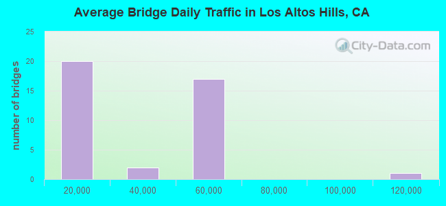
- National Bridge Inventory (NBI) Statistics
- 40Number of bridges
- 262ft / 80.2mTotal length
- 1,187,380Total average daily traffic
- 24,630Total average daily truck traffic
- National Bridge Inventory (NBI) Registered Bridges for Los Altos Hills
- No street view available for this location

- New bridges - historical statistics
- 321960-1969
- 21970-1979
- 21980-1989
- 21990-1999
- 12000-2009
- 12010-2019
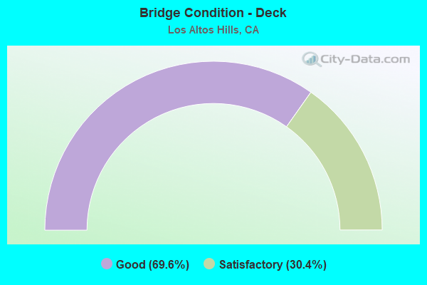
- Bridge Condition - Deck
- 69.6%Good
- 30.4%Satisfactory
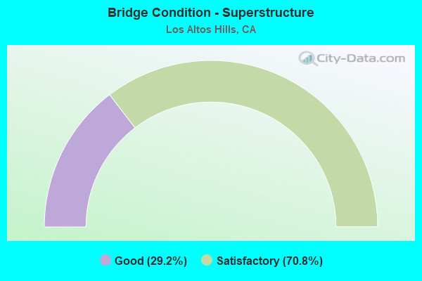
- Bridge Condition - Superstructure
- 29.2%Good
- 70.8%Satisfactory
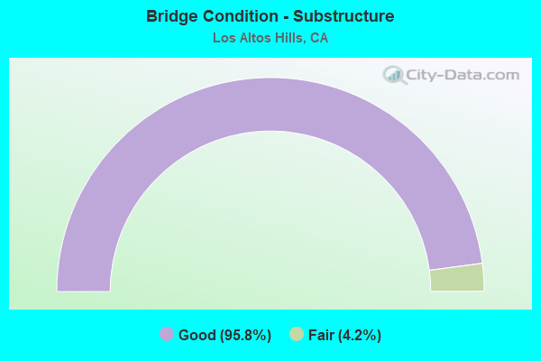
- Bridge Condition - Substructure
- 95.8%Good
- 4.2%Fair
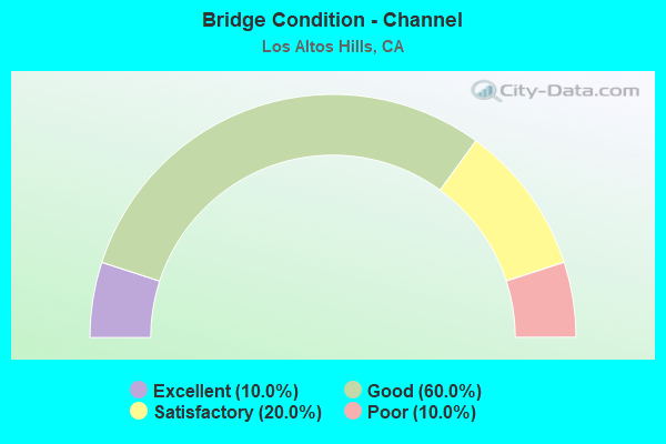
- Bridge Condition - Channel
- 10.0%Excellent
- 60.0%Good
- 20.0%Satisfactory
- 10.0%Poor
Find on map >> Show street view
Structure Number: 37 0225L, Location: 04-SCL-280-14.10 (Lat: 37.352778, Lng: -122.107189), Route carried "on" structure: Interstate 280, Year Built: 1967, Status: Open, Structure Length: 4.48m (14.70ft), Average Daily Traffic: 58,500 (year 2009), Truck Traffic: 2%, Average Future Daily Traffic: 81,506 (year 2044), Design Load: HS 20, Features Intersected: MAGDALENA AVENUE
Minimum Vertical Clearance: 30+ m (98+ ft), Kilometerpoint: 14.100, Lanes on structure: 4, Lanes under structure: 4, Base Highway Network: Yes (Inventory Route: 2, Subroute: 1), Owner: State Highway Agency, Approaching Roadway Width: 23.0m (75.5ft), Skew: 1 degrees, Material/Design: Concrete continuous, Design/Construction: Box Beam or Girders - Multiple, Number Of Spans In Main Unit: 2, Length of Maximum Span: 23.1m (75.8ft), Curb-To-Curb Width: 22.3m (73.2ft), Out-to-Out Width: 23.4m (76.8ft)
Condition: Deck: Good, Superstructure: Satisfactory, Substructure: Good, Operating Rating: 62.9 metric tons, Method Used To Determine Operating Rating: Load Factor (LF), Inventory Rating: 37.9 metric tons, Method Used To Determine Inventory Rating: Load Factor (LF), Structural Evaluation: Equal to present minimum criteria, Deck Geometry: Superior to present desirable criteria, Underclear: Equal to present minimum criteria, Approach Roadway Alignment: Better than present minimum criteria, Designated Inspection Frequency: Every 48 months, Inspection Date: Febuary 2022, Deck Structure Type: Concrete Cast-file-Place
Find on map >> Show street view
Structure Number: 37 0225R, Location: 04-SCL-280-14.10 (Lat: 37.352903, Lng: -122.106928), Route carried "on" structure: Interstate 280, Year Built: 1967, Status: Open, Structure Length: 4.18m (13.71ft), Average Daily Traffic: 58,500 (year 2009), Truck Traffic: 2%, Average Future Daily Traffic: 81,506 (year 2044), Design Load: HS 20, Features Intersected: MAGDALENA AVENUE
Minimum Vertical Clearance: 30+ m (98+ ft), Kilometerpoint: 14.100, Lanes on structure: 4, Lanes under structure: 4, Base Highway Network: Yes (Inventory Route: 2, Subroute: 1), Owner: State Highway Agency, Approaching Roadway Width: 20.5m (67.3ft), Skew: 1 degrees, Material/Design: Concrete continuous, Design/Construction: Box Beam or Girders - Multiple, Number Of Spans In Main Unit: 2, Length of Maximum Span: 21.6m (70.9ft), Curb-To-Curb Width: 20.1m (65.9ft), Out-to-Out Width: 21.2m (69.6ft)
Condition: Deck: Good, Superstructure: Satisfactory, Substructure: Good, Operating Rating: 69.0 metric tons, Method Used To Determine Operating Rating: Load Factor (LF), Inventory Rating: 41.5 metric tons, Method Used To Determine Inventory Rating: Load Factor (LF), Structural Evaluation: Equal to present minimum criteria, Deck Geometry: Equal to present minimum criteria, Underclear: Equal to present minimum criteria, Approach Roadway Alignment: Better than present minimum criteria, Designated Inspection Frequency: Every 48 months, Inspection Date: Febuary 2022, Deck Structure Type: Concrete Cast-file-Place
Find on map >> Show street view
Structure Number: 37 0233L, Location: 04-SCL-280-16.56-LAH (Lat: 37.370917, Lng: -122.142692), Route carried "on" structure: Interstate 280, Year Built: 1967, Status: Open, Structure Length: 2.90m (9.51ft), Average Daily Traffic: 58,500 (year 2009), Truck Traffic: 2%, Average Future Daily Traffic: 81,506 (year 2044), Design Load: HS 20+Mod, Features Intersected: LA BARRANCA WAY
Minimum Vertical Clearance: 30+ m (98+ ft), Kilometerpoint: 16.560, Lanes on structure: 4, Lanes under structure: 2, Base Highway Network: Yes (Inventory Route: 2, Subroute: 1), Owner: State Highway Agency, Approaching Roadway Width: 20.5m (67.3ft), Skew: 2 degrees, Material/Design: Prestressed concrete, Design/Construction: Box Beam or Girders - Multiple, Number Of Spans In Main Unit: 1, Length of Maximum Span: 28.3m (92.8ft), Curb-To-Curb Width: 20.1m (65.9ft), Out-to-Out Width: 21.2m (69.6ft)
Condition: Deck: Good, Superstructure: Satisfactory, Substructure: Good, Operating Rating: 54.1 metric tons, Method Used To Determine Operating Rating: Field evaluation and documented engineering judgment, Inventory Rating: 32.4 metric tons, Method Used To Determine Inventory Rating: Field evaluation and documented engineering judgment, Structural Evaluation: Equal to present minimum criteria, Deck Geometry: Equal to present minimum criteria, Underclear: Meets minimum limits, Approach Roadway Alignment: Equal to present desirable criteria, Designated Inspection Frequency: Every 48 months, Inspection Date: Febuary 2022, Deck Structure Type: Concrete Cast-file-Place
Find on map >> Show street view
Structure Number: 37 0233R, Location: 04-SCL-280-16.56-LAH (Lat: 37.371194, Lng: -122.142575), Route carried "on" structure: Interstate 280, Year Built: 1967, Status: Open, Structure Length: 2.57m (8.43ft), Average Daily Traffic: 58,500 (year 2009), Truck Traffic: 2%, Average Future Daily Traffic: 81,506 (year 2044), Design Load: HS 20+Mod, Features Intersected: LA BARRANCA WAY
Minimum Vertical Clearance: 30+ m (98+ ft), Kilometerpoint: 16.560, Lanes on structure: 4, Lanes under structure: 2, Base Highway Network: Yes (Inventory Route: 2, Subroute: 1), Owner: State Highway Agency, Approaching Roadway Width: 20.5m (67.3ft), Skew: 2 degrees, Material/Design: Prestressed concrete, Design/Construction: Box Beam or Girders - Multiple, Number Of Spans In Main Unit: 1, Length of Maximum Span: 24.9m (81.7ft), Curb-To-Curb Width: 20.1m (65.9ft), Out-to-Out Width: 21.2m (69.6ft)
Condition: Deck: Good, Superstructure: Satisfactory, Substructure: Good, Operating Rating: 54.1 metric tons, Method Used To Determine Operating Rating: Field evaluation and documented engineering judgment, Inventory Rating: 32.4 metric tons, Method Used To Determine Inventory Rating: Field evaluation and documented engineering judgment, Structural Evaluation: Equal to present minimum criteria, Deck Geometry: Equal to present minimum criteria, Underclear: Meets minimum limits, Approach Roadway Alignment: Equal to present desirable criteria, Designated Inspection Frequency: Every 48 months, Inspection Date: Febuary 2022, Deck Structure Type: Concrete Cast-file-Place
Find on map >> Show street view
Structure Number: 37 0238L, Location: 04-SCL-280-15.05-LAH (Lat: 37.361053, Lng: -122.120075), Route carried "on" structure: Interstate 280, Year Built: 1967, Status: Open, Structure Length: 5.00m (16.40ft), Average Daily Traffic: 58,500 (year 2009), Truck Traffic: 2%, Average Future Daily Traffic: 78,316 (year 2040), Design Load: HS 20, Features Intersected: EL MONTE ROAD
Minimum Vertical Clearance: 30+ m (98+ ft), Kilometerpoint: 15.050, Lanes on structure: 6, Lanes under structure: 6, Base Highway Network: Yes (Inventory Route: 2, Subroute: 1), Owner: State Highway Agency, Approaching Roadway Width: 30.0m (98.4ft), Skew: 32 degrees, Material/Design: Concrete continuous, Design/Construction: Box Beam or Girders - Multiple, Number Of Spans In Main Unit: 2, Length of Maximum Span: 25.0m (82.0ft), Curb-To-Curb Width: 29.3m (96.1ft), Out-to-Out Width: 33.4m (109.6ft)
Condition: Deck: Satisfactory, Superstructure: Satisfactory, Substructure: Good, Operating Rating: 49.6 metric tons, Method Used To Determine Operating Rating: Load and Resistance Factor Rating (LRFR) rating reported by rating factor(RF) method using HL-93 loadings, Inventory Rating: 38.2 metric tons, Method Used To Determine Inventory Rating: Load and Resistance Factor Rating (LRFR) rating reported by rating factor(RF) method using HL-93 loadings, Structural Evaluation: Equal to present minimum criteria, Deck Geometry: Better than present minimum criteria, Underclear: Meets minimum limits, Approach Roadway Alignment: Better than present minimum criteria, Designated Inspection Frequency: Every 48 months, Inspection Date: Febuary 2020, Deck Structure Type: Concrete Cast-file-Place
Find on map >> Show street view
Structure Number: 37 0238R, Location: 04-SCL-280-15.05-LAH (Lat: 37.361319, Lng: -122.119761), Route carried "on" structure: Interstate 280, Year Built: 1967, Status: Open, Structure Length: 4.80m (15.75ft), Average Daily Traffic: 58,500 (year 2009), Truck Traffic: 2%, Average Future Daily Traffic: 78,316 (year 2040), Design Load: HS 20, Features Intersected: EL MONTE ROAD
Minimum Vertical Clearance: 30+ m (98+ ft), Kilometerpoint: 15.050, Lanes on structure: 6, Lanes under structure: 6, Base Highway Network: Yes (Inventory Route: 2, Subroute: 1), Owner: State Highway Agency, Approaching Roadway Width: 30.0m (98.4ft), Skew: 32 degrees, Material/Design: Concrete continuous, Design/Construction: Box Beam or Girders - Multiple, Number Of Spans In Main Unit: 2, Length of Maximum Span: 24.5m (80.4ft), Curb-To-Curb Width: 29.3m (96.1ft), Out-to-Out Width: 33.4m (109.6ft)
Condition: Deck: Satisfactory, Superstructure: Satisfactory, Substructure: Good, Operating Rating: 82.3 metric tons, Method Used To Determine Operating Rating: Load Factor (LF), Inventory Rating: 49.2 metric tons, Method Used To Determine Inventory Rating: Load Factor (LF), Structural Evaluation: Equal to present minimum criteria, Deck Geometry: Better than present minimum criteria, Underclear: Meets minimum limits, Approach Roadway Alignment: Better than present minimum criteria, Designated Inspection Frequency: Every 48 months, Inspection Date: Febuary 2020, Deck Structure Type: Concrete Cast-file-Place
Find on map >> Show street view
Structure Number: 37 0241K, Location: 04-SCL-280-11.47-LATS (Lat: 37.333414, Lng: -122.069303), Route carried "on" structure: Ramp Interstate 280, Year Built: 1967, Status: Open, Structure Length: 5.18m (16.99ft), Average Daily Traffic: 3,800 (year 1998), Truck Traffic: 2%, Average Future Daily Traffic: 5,470 (year 2042), Design Load: HS 20, Features Intersected: UP RR
Minimum Vertical Clearance: 30+ m (98+ ft), Kilometerpoint: 11.470, Lanes on structure: 1, Base Highway Network: Yes, Owner: State Highway Agency, Approaching Roadway Width: 7.9m (25.9ft), Material/Design: Concrete continuous, Design/Construction: Box Beam or Girders - Multiple, Number Of Spans In Main Unit: 2, Length of Maximum Span: 26.4m (86.6ft), Curb-To-Curb Width: 7.9m (25.9ft), Out-to-Out Width: 9.0m (29.5ft)
Condition: Deck: Good, Superstructure: Satisfactory, Substructure: Good, Operating Rating: 65.4 metric tons, Method Used To Determine Operating Rating: Load Factor (LF), Inventory Rating: 39.2 metric tons, Method Used To Determine Inventory Rating: Load Factor (LF), Structural Evaluation: Equal to present minimum criteria, Deck Geometry: Equal to present desirable criteria, Underclear: Equal to present minimum criteria, Approach Roadway Alignment: Somewhat better than minimum adequacy, Designated Inspection Frequency: Every 48 months, Inspection Date: January 2020, Deck Structure Type: Concrete Cast-file-Place
Find on map >> Show street view
Structure Number: 37 0249L, Location: 04-SCL-280-16.01-LAH (Lat: 37.366272, Lng: -122.135358), Route carried "on" structure: Interstate 280, Year Built: 1967, Status: Open, Structure Length: 2.99m (9.81ft), Average Daily Traffic: 58,500 (year 2009), Truck Traffic: 2%, Average Future Daily Traffic: 81,506 (year 2044), Design Load: HS 20, Features Intersected: ROBLEDA ROAD
Minimum Vertical Clearance: 30+ m (98+ ft), Kilometerpoint: 16.010, Lanes on structure: 4, Lanes under structure: 2, Base Highway Network: Yes (Inventory Route: 2, Subroute: 1), Owner: State Highway Agency, Approaching Roadway Width: 20.2m (66.3ft), Skew: 2 degrees, Material/Design: Prestressed concrete, Design/Construction: Box Beam or Girders - Multiple, Number Of Spans In Main Unit: 1, Length of Maximum Span: 29.2m (95.8ft), Curb-To-Curb Width: 20.1m (65.9ft), Out-to-Out Width: 21.2m (69.6ft)
Condition: Deck: Good, Superstructure: Satisfactory, Substructure: Good, Operating Rating: 99.8 metric tons, Method Used To Determine Operating Rating: Load Factor (LF), Inventory Rating: 32.4 metric tons, Method Used To Determine Inventory Rating: Load Factor (LF), Structural Evaluation: Equal to present minimum criteria, Deck Geometry: Equal to present minimum criteria, Underclear: Somewhat better than minimum adequacy, Approach Roadway Alignment: Equal to present desirable criteria, Designated Inspection Frequency: Every 48 months, Inspection Date: Febuary 2022, Deck Structure Type: Concrete Cast-file-Place
Find on map >> Show street view
Structure Number: 37 0249R, Location: 04-SCL-280-16.01-LAH (Lat: 37.366453, Lng: -122.135117), Route carried "on" structure: Interstate 280, Year Built: 1967, Status: Open, Structure Length: 2.75m (9.02ft), Average Daily Traffic: 58,500 (year 2009), Truck Traffic: 2%, Average Future Daily Traffic: 78,316 (year 2040), Design Load: HS 20, Features Intersected: ROBLEDA ROAD
Minimum Vertical Clearance: 30+ m (98+ ft), Kilometerpoint: 16.010, Lanes on structure: 4, Lanes under structure: 2, Base Highway Network: Yes (Inventory Route: 2, Subroute: 1), Owner: State Highway Agency, Approaching Roadway Width: 20.2m (66.3ft), Skew: 2 degrees, Material/Design: Prestressed concrete, Design/Construction: Box Beam or Girders - Multiple, Number Of Spans In Main Unit: 1, Length of Maximum Span: 26.8m (87.9ft), Curb-To-Curb Width: 20.1m (65.9ft), Out-to-Out Width: 21.2m (69.6ft)
Condition: Deck: Good, Superstructure: Satisfactory, Substructure: Good, Operating Rating: 91.4 metric tons, Method Used To Determine Operating Rating: Load Factor (LF), Inventory Rating: 32.4 metric tons, Method Used To Determine Inventory Rating: Load Factor (LF), Structural Evaluation: Equal to present minimum criteria, Deck Geometry: Equal to present minimum criteria, Underclear: Somewhat better than minimum adequacy, Approach Roadway Alignment: Equal to present desirable criteria, Designated Inspection Frequency: Every 48 months, Inspection Date: Febuary 2022, Deck Structure Type: Concrete Cast-file-Place
Find on map >> Show street view
Structure Number: 37 0250R, Location: 04-SCL-280-17.35-LAH (Lat: 37.380517, Lng: -122.151047), Route carried "on" structure: Interstate 280, Year Built: 1967, Status: Open, Structure Length: 2.44m (8.01ft), Average Daily Traffic: 58,500 (year 2009), Truck Traffic: 2%, Average Future Daily Traffic: 81,506 (year 2044), Design Load: HS 20, Features Intersected: ELENA ROAD
Minimum Vertical Clearance: 30+ m (98+ ft), Kilometerpoint: 17.350, Lanes on structure: 4, Lanes under structure: 2, Base Highway Network: Yes (Inventory Route: 2, Subroute: 1), Owner: State Highway Agency, Approaching Roadway Width: 20.5m (67.3ft), Material/Design: Prestressed concrete, Design/Construction: Box Beam or Girders - Multiple, Number Of Spans In Main Unit: 1, Length of Maximum Span: 23.6m (77.4ft), Curb-To-Curb Width: 20.1m (65.9ft), Out-to-Out Width: 21.2m (69.6ft)
Condition: Deck: Good, Superstructure: Satisfactory, Substructure: Good, Operating Rating: 97.2 metric tons, Method Used To Determine Operating Rating: Load Factor (LF), Inventory Rating: 32.4 metric tons, Method Used To Determine Inventory Rating: Load Factor (LF), Structural Evaluation: Equal to present minimum criteria, Deck Geometry: Equal to present minimum criteria, Underclear: Somewhat better than minimum adequacy, Approach Roadway Alignment: Better than present minimum criteria, Designated Inspection Frequency: Every 48 months, Inspection Date: Febuary 2022, Deck Structure Type: Concrete Cast-file-Place
Find on map >> Show street view
Structure Number: 37 0251L, Location: 04-SCL-280-17.78-LAH (Lat: 37.386286, Lng: -122.153428), Route carried "on" structure: Interstate 280, Year Built: 1967, Status: Open, Structure Length: 4.43m (14.53ft), Average Daily Traffic: 58,500 (year 2009), Truck Traffic: 2%, Average Future Daily Traffic: 78,839 (year 2042), Design Load: HS 20, Features Intersected: ARASTRADERO ROAD
Minimum Vertical Clearance: 30+ m (98+ ft), Kilometerpoint: 17.780, Lanes on structure: 4, Lanes under structure: 2, Base Highway Network: Yes (Inventory Route: 2, Subroute: 1), Owner: State Highway Agency, Approaching Roadway Width: 20.5m (67.3ft), Skew: 9 degrees, Material/Design: Concrete continuous, Design/Construction: Box Beam or Girders - Multiple, Number Of Spans In Main Unit: 2, Length of Maximum Span: 24.1m (79.1ft), Curb-To-Curb Width: 20.1m (65.9ft), Out-to-Out Width: 21.2m (69.6ft)
Condition: Deck: Satisfactory, Superstructure: Satisfactory, Substructure: Good, Operating Rating: 67.7 metric tons, Method Used To Determine Operating Rating: Load Factor (LF), Inventory Rating: 40.5 metric tons, Method Used To Determine Inventory Rating: Load Factor (LF), Structural Evaluation: Equal to present minimum criteria, Deck Geometry: Equal to present minimum criteria, Underclear: Equal to present minimum criteria, Approach Roadway Alignment: Better than present minimum criteria, Designated Inspection Frequency: Every 48 months, Inspection Date: Febuary 2020, Deck Structure Type: Concrete Cast-file-Place
Find on map >> Show street view
Structure Number: 37 0251R, Location: 04-SCL-280-17.78-LAH (Lat: 37.386394, Lng: -122.153144), Route carried "on" structure: Interstate 280, Year Built: 1967, Status: Open, Structure Length: 4.02m (13.19ft), Average Daily Traffic: 58,500 (year 2009), Truck Traffic: 2%, Average Future Daily Traffic: 78,316 (year 2040), Design Load: HS 20, Features Intersected: ARASTRADERO ROAD
Minimum Vertical Clearance: 30+ m (98+ ft), Kilometerpoint: 17.780, Lanes on structure: 4, Lanes under structure: 2, Base Highway Network: Yes (Inventory Route: 2, Subroute: 1), Owner: State Highway Agency, Approaching Roadway Width: 20.5m (67.3ft), Material/Design: Concrete continuous, Design/Construction: Box Beam or Girders - Multiple, Number Of Spans In Main Unit: 2, Length of Maximum Span: 21.6m (70.9ft), Curb-To-Curb Width: 20.1m (65.9ft), Out-to-Out Width: 21.1m (69.2ft)
Condition: Deck: Satisfactory, Superstructure: Satisfactory, Substructure: Fair, Operating Rating: 50.9 metric tons, Method Used To Determine Operating Rating: Load Factor (LF), Inventory Rating: 30.5 metric tons, Method Used To Determine Inventory Rating: Load Factor (LF), Structural Evaluation: Somewhat better than minimum adequacy, Deck Geometry: Equal to present minimum criteria, Underclear: Equal to present minimum criteria, Approach Roadway Alignment: Better than present minimum criteria, Designated Inspection Frequency: Every 24 months, Inspection Date: Febuary 2022, Deck Structure Type: Concrete Cast-file-Place
Find on map >> Show street view
Structure Number: 37 0252K, Location: 04-SCL-280-18.38 (Lat: 37.389325, Lng: -122.163239), Route carried "on" structure: Ramp Interstate 280, Year Built: 1969, Status: Open, Structure Length: 5.60m (18.37ft), Average Daily Traffic: 7,600 (year 1998), Truck Traffic: 2%, Average Future Daily Traffic: 13,128 (year 2042), Design Load: HS 20, Features Intersected: PAGE MILL ROAD
Minimum Vertical Clearance: 30+ m (98+ ft), Kilometerpoint: 18.380, Lanes on structure: 2, Lanes under structure: 5, Base Highway Network: Yes (Inventory Route: 2, Subroute: 1), Owner: State Highway Agency, Approaching Roadway Width: 9.8m (32.2ft), Skew: 2 degrees, Material/Design: Concrete continuous, Design/Construction: Box Beam or Girders - Multiple, Number Of Spans In Main Unit: 2, Length of Maximum Span: 28.0m (91.9ft), Curb-To-Curb Width: 9.8m (32.2ft), Out-to-Out Width: 11.0m (36.1ft)
Condition: Deck: Satisfactory, Superstructure: Satisfactory, Substructure: Good, Operating Rating: 66.4 metric tons, Method Used To Determine Operating Rating: Load Factor (LF), Inventory Rating: 39.9 metric tons, Method Used To Determine Inventory Rating: Load Factor (LF), Structural Evaluation: Equal to present minimum criteria, Deck Geometry: Equal to present minimum criteria, Underclear: Equal to present minimum criteria, Approach Roadway Alignment: Meets minimum limits, Designated Inspection Frequency: Every 48 months, Inspection Date: Febuary 2020, Deck Structure Type: Concrete Cast-file-Place
Find on map >> Show street view
Structure Number: 37 0252L, Location: 04-SCL-280-18.38 (Lat: 37.389547, Lng: -122.163181), Route carried "on" structure: Interstate 280, Year Built: 1969, Status: Open, Structure Length: 5.73m (18.80ft), Average Daily Traffic: 58,500 (year 2009), Truck Traffic: 2%, Average Future Daily Traffic: 78,316 (year 2040), Design Load: HS 20, Features Intersected: PAGE MILL ROAD
Minimum Vertical Clearance: 30+ m (98+ ft), Kilometerpoint: 18.380, Lanes on structure: 3, Lanes under structure: 5, Base Highway Network: Yes (Inventory Route: 2, Subroute: 1), Owner: State Highway Agency, Approaching Roadway Width: 20.2m (66.3ft), Skew: 2 degrees, Material/Design: Concrete continuous, Design/Construction: Box Beam or Girders - Multiple, Number Of Spans In Main Unit: 2, Length of Maximum Span: 28.3m (92.8ft), Curb-To-Curb Width: 20.1m (65.9ft), Out-to-Out Width: 21.2m (69.6ft)
Condition: Deck: Good, Superstructure: Satisfactory, Substructure: Good, Operating Rating: 69.7 metric tons, Method Used To Determine Operating Rating: Load Factor (LF), Inventory Rating: 41.8 metric tons, Method Used To Determine Inventory Rating: Load Factor (LF), Structural Evaluation: Equal to present minimum criteria, Deck Geometry: Superior to present desirable criteria, Underclear: Equal to present minimum criteria, Approach Roadway Alignment: Better than present minimum criteria, Designated Inspection Frequency: Every 48 months, Inspection Date: Febuary 2022, Deck Structure Type: Concrete Cast-file-Place
Find on map >> Show street view
Structure Number: 37 0252R, Location: 04-SCL-280-18.38 (Lat: 37.389794, Lng: -122.163119), Route carried "on" structure: Interstate 280, Year Built: 1969, Status: Open, Structure Length: 5.91m (19.39ft), Average Daily Traffic: 58,500 (year 2009), Truck Traffic: 2%, Average Future Daily Traffic: 78,316 (year 2040), Design Load: HS 20, Features Intersected: PAGE MILL ROAD
Minimum Vertical Clearance: 30+ m (98+ ft), Kilometerpoint: 18.380, Lanes on structure: 4, Lanes under structure: 5, Base Highway Network: Yes (Inventory Route: 2, Subroute: 1), Owner: State Highway Agency, Approaching Roadway Width: 20.5m (67.3ft), Skew: 2 degrees, Material/Design: Concrete continuous, Design/Construction: Box Beam or Girders - Multiple, Number Of Spans In Main Unit: 2, Length of Maximum Span: 29.2m (95.8ft), Curb-To-Curb Width: 20.1m (65.9ft), Out-to-Out Width: 21.2m (69.6ft)
Condition: Deck: Good, Superstructure: Satisfactory, Substructure: Good, Operating Rating: 69.7 metric tons, Method Used To Determine Operating Rating: Load Factor (LF), Inventory Rating: 41.8 metric tons, Method Used To Determine Inventory Rating: Load Factor (LF), Structural Evaluation: Equal to present minimum criteria, Deck Geometry: Equal to present minimum criteria, Underclear: Equal to present minimum criteria, Approach Roadway Alignment: Better than present minimum criteria, Designated Inspection Frequency: Every 48 months, Inspection Date: Febuary 2022, Deck Structure Type: Concrete Cast-file-Place
Find on map >> Show street view
Structure Number: 37 0252S, Location: 04-SCL-280-18.38 (Lat: 37.389928, Lng: -122.163100), Route carried "on" structure: Ramp Interstate 280, Year Built: 1969, Status: Open, Structure Length: 5.52m (18.11ft), Average Daily Traffic: 7,000 (year 1998), Truck Traffic: 2%, Average Future Daily Traffic: 21,519 (year 2042), Design Load: HS 20, Features Intersected: PAGE MILL ROAD
Minimum Vertical Clearance: 30+ m (98+ ft), Kilometerpoint: 18.380, Lanes on structure: 1, Lanes under structure: 5, Base Highway Network: Yes (Inventory Route: 2, Subroute: 1), Owner: State Highway Agency, Approaching Roadway Width: 10.0m (32.8ft), Skew: 2 degrees, Material/Design: Concrete continuous, Design/Construction: Box Beam or Girders - Multiple, Number Of Spans In Main Unit: 2, Length of Maximum Span: 27.3m (89.6ft), Curb-To-Curb Width: 9.8m (32.2ft), Out-to-Out Width: 11.0m (36.1ft)
Condition: Deck: Satisfactory, Superstructure: Satisfactory, Substructure: Good, Operating Rating: 66.4 metric tons, Method Used To Determine Operating Rating: Load Factor (LF), Inventory Rating: 39.9 metric tons, Method Used To Determine Inventory Rating: Load Factor (LF), Structural Evaluation: Equal to present minimum criteria, Deck Geometry: Superior to present desirable criteria, Underclear: Equal to present minimum criteria, Approach Roadway Alignment: Equal to present minimum criteria, Designated Inspection Frequency: Every 48 months, Inspection Date: Febuary 2020, Deck Structure Type: Concrete Cast-file-Place
Find on map >> Show street view
Structure Number: 37 0336, Location: 04-SCL-280-15.17-LAH (Lat: 37.362692, Lng: -122.121506), Route carried "on" structure: Interstate 280, Year Built: 1967, Status: Open, Structure Length: 0.73m (2.40ft), Average Daily Traffic: 117,000 (year 2009), Truck Traffic: 2%, Average Future Daily Traffic: 157,677 (year 2042), Features Intersected: ADOBE CREEK
Minimum Vertical Clearance: 30+ m (98+ ft), Kilometerpoint: 15.170, Lanes on structure: 8, Base Highway Network: Yes (Inventory Route: 2, Subroute: 1), Owner: State Highway Agency, Approaching Roadway Width: 43.9m (144.0ft), Skew: 20 degrees, Material/Design: Concrete continuous, Design/Construction: Culvert, Number Of Spans In Main Unit: 2, Length of Maximum Span: 3.4m (11.2ft)
Condition: Channel: Good, Culverts: Good, Operating Rating: 54.1 metric tons, Method Used To Determine Operating Rating: Field evaluation and documented engineering judgment, Inventory Rating: 32.4 metric tons, Method Used To Determine Inventory Rating: Field evaluation and documented engineering judgment, Structural Evaluation: Better than present minimum criteria, Waterway Adequacy: Superior to present desirable criteria, Approach Roadway Alignment: Better than present minimum criteria, Designated Inspection Frequency: Every 48 months, Inspection Date: Febuary 2020
Find on map >> Show street view
Structure Number: 37C0193, Location: BTWN MOODY RD & MONTE RD (Lat: 37.358417, Lng: -122.129172), Route carried "on" structure: City street , Year Built: 1965, Status: Open, Structure Length: 0.71m (2.33ft), Average Daily Traffic: 10,000 (year 2016), Truck Traffic: 6%, Average Future Daily Traffic: 15,400 (year 2040), Features Intersected: ADOBE CREEK, Facility Carried by Structure: ELENA RD
Minimum Vertical Clearance: 30+ m (98+ ft), Kilometerpoint: 0.000, Lanes on structure: 3, Owner: City or Municipal Highway Agency, Approaching Roadway Width: 7.6m (24.9ft), Skew: 9 degrees, Material/Design: Concrete continuous, Design/Construction: Culvert, Number Of Spans In Main Unit: 2, Length of Maximum Span: 3.6m (11.8ft), Curb or Sidewalk Widths: Left: 0.4m (1.3ft), Right: 0.4m (1.3ft), Curb-To-Curb Width: 12.5m (41.0ft), Out-to-Out Width: 13.3m (43.6ft)
Condition: Channel: Satisfactory, Culverts: Good, Operating Rating: 40.5 metric tons, Method Used To Determine Operating Rating: Field evaluation and documented engineering judgment, Inventory Rating: 24.3 metric tons, Method Used To Determine Inventory Rating: Field evaluation and documented engineering judgment, Structural Evaluation: Equal to present minimum criteria, Deck Geometry: Meets minimum limits, Waterway Adequacy: Equal to present minimum criteria, Approach Roadway Alignment: Equal to present minimum criteria, Designated Inspection Frequency: Every 24 months, Inspection Date: April 2020, Deck Structure Type: Concrete Cast-file-Place, Wearing Surface/Protective System: Wearing Surface: Bituminous
Find on map >> Show street view
Structure Number: 37C0204, Location: .15 MI W/O FOOTHILL EXPWY (Lat: 37.381153, Lng: -122.123492), Route carried "on" structure: City street , Year Built: 1985, Status: Open, Structure Length: 1.37m (4.49ft), Average Daily Traffic: 5,000 (year 2016), Truck Traffic: 2%, Average Future Daily Traffic: 6,400 (year 2040), Design Load: HS 20, Features Intersected: ADOBE CREEK, Facility Carried by Structure: WEST EDITH AVE
Minimum Vertical Clearance: 30+ m (98+ ft), Kilometerpoint: 0.000, Lanes on structure: 2, Owner: City or Municipal Highway Agency, Approaching Roadway Width: 11.0m (36.1ft), Material/Design: Concrete, Design/Construction: Slab, Number Of Spans In Main Unit: 1, Length of Maximum Span: 12.5m (41.0ft), Curb-To-Curb Width: 12.6m (41.3ft), Out-to-Out Width: 13.3m (43.6ft)
Condition: Deck: Satisfactory, Superstructure: Satisfactory, Substructure: Good, Channel: Satisfactory, Operating Rating: 66.7 metric tons, Method Used To Determine Operating Rating: Load and Resistance Factor Rating (LRFR) rating reported by rating factor(RF) method using HL-93 loadings, Inventory Rating: 51.5 metric tons, Method Used To Determine Inventory Rating: Load and Resistance Factor Rating (LRFR) rating reported by rating factor(RF) method using HL-93 loadings, Structural Evaluation: Equal to present minimum criteria, Deck Geometry: Equal to present minimum criteria, Waterway Adequacy: Somewhat better than minimum adequacy, Approach Roadway Alignment: Somewhat better than minimum adequacy, Designated Inspection Frequency: Every 48 months, Inspection Date: April 2020, Deck Structure Type: Concrete Cast-file-Place
Find on map >> Show street view
Structure Number: 37C0417, Location: WEST OF PAGE MILL ROAD (Lat: 37.385197, Lng: -122.169897), Route carried "on" structure: City street , Year Built: 2002, Status: Open, Structure Length: 1.13m (3.71ft), Average Daily Traffic: 100 (year 2010), Truck Traffic: 1%, Average Future Daily Traffic: 225 (year 2040), Design Load: HS 20+Mod, Features Intersected: ARASTRADERO CREEK, Facility Carried by Structure: TRACY COURT
Minimum Vertical Clearance: 30+ m (98+ ft), Kilometerpoint: 0.000, Lanes on structure: 2, Owner: City or Municipal Highway Agency, Approaching Roadway Width: 9.0m (29.5ft), Skew: 2 degrees, Material/Design: Prestressed concrete, Design/Construction: Slab, Number Of Spans In Main Unit: 1, Length of Maximum Span: 11.3m (37.1ft), Curb-To-Curb Width: 9.0m (29.5ft), Out-to-Out Width: 10.1m (33.1ft)
Condition: Deck: Good, Superstructure: Good, Substructure: Good, Channel: Excellent, Operating Rating: 54.1 metric tons, Method Used To Determine Operating Rating: Assigned rating based on Load Factor Design (LFD) reported in metric tons, Inventory Rating: 32.4 metric tons, Method Used To Determine Inventory Rating: Assigned rating based on Load Factor Design (LFD) reported in metric tons, Structural Evaluation: Better than present minimum criteria, Deck Geometry: Better than present minimum criteria, Waterway Adequacy: Equal to present desirable criteria, Approach Roadway Alignment: Equal to present minimum criteria, Designated Inspection Frequency: Every 48 months, Inspection Date: April 2020, Deck Structure Type: Concrete Cast-file-Place, Wearing Surface/Protective System: Wearing Surface: Integral Concrete
Find on map >> Show street view
Structure Number: 37C044, Location: JUST EAST OF PURISSIMA RD (Lat: 37.380750, Lng: -122.150000), Route carried "on" structure: City street , Year Built: 2013, Status: Open, Structure Length: 2.58m (8.46ft), Average Daily Traffic: 100 (year 2016), Truck Traffic: 2%, Average Future Daily Traffic: 200 (year 2036), Features Intersected: DEER CREEK, Facility Carried by Structure: DEER CREEK LANE
Minimum Vertical Clearance: 30+ m (98+ ft), Kilometerpoint: 0.000, Lanes on structure: 2, Owner: City or Municipal Highway Agency, Approaching Roadway Width: 7.3m (24.0ft), Material/Design: Steel, Design/Construction: Stringer/Multi-beam, Number Of Spans In Main Unit: 1, Length of Maximum Span: 25.8m (84.6ft), Curb or Sidewalk Widths: Left: 0.5m (1.6ft), Right: 0.3m (1.0ft), Curb-To-Curb Width: 7.3m (24.0ft), Out-to-Out Width: 8.2m (26.9ft)
Condition: Deck: Good, Superstructure: Good, Substructure: Good, Channel: Good, Operating Rating: 54.1 metric tons, Method Used To Determine Operating Rating: Field evaluation and documented engineering judgment, Inventory Rating: 32.4 metric tons, Method Used To Determine Inventory Rating: Field evaluation and documented engineering judgment, Structural Evaluation: Better than present minimum criteria, Deck Geometry: Equal to present minimum criteria, Waterway Adequacy: Better than present minimum criteria, Approach Roadway Alignment: Equal to present desirable criteria, Designated Inspection Frequency: Every 48 months, Inspection Date: April 2018, Deck Structure Type: Steel plate, Wearing Surface/Protective System: Wearing Surface: Monolithic Concrete
Find on map >> Show street view
Structure Number: 37C0441, Location: JUST EAST OF PURISSIMA RD (Lat: 37.379792, Lng: -122.149972), Route carried "on" structure: City street , Year Built: 1996, Status: Open, Structure Length: 1.07m (3.51ft), Average Daily Traffic: 100 (year 2016), Truck Traffic: 2%, Average Future Daily Traffic: 215 (year 2040), Design Load: HS 20, Features Intersected: DEER CREEK, Facility Carried by Structure: SAMUEL LANE
Minimum Vertical Clearance: 30+ m (98+ ft), Kilometerpoint: 0.000, Lanes on structure: 2, Owner: City or Municipal Highway Agency, Approaching Roadway Width: 7.9m (25.9ft), Material/Design: Steel, Design/Construction: Stringer/Multi-beam, Number Of Spans In Main Unit: 1, Length of Maximum Span: 10.7m (35.1ft), Curb or Sidewalk Widths: Left: 0.3m (1.0ft), Right: 1.7m (5.6ft), Curb-To-Curb Width: 6.1m (20.0ft), Out-to-Out Width: 8.3m (27.2ft)
Condition: Deck: Good, Superstructure: Good, Substructure: Good, Channel: Good, Operating Rating: 54.1 metric tons, Method Used To Determine Operating Rating: Field evaluation and documented engineering judgment, Inventory Rating: 32.4 metric tons, Method Used To Determine Inventory Rating: Field evaluation and documented engineering judgment, Structural Evaluation: Better than present minimum criteria, Deck Geometry: Somewhat better than minimum adequacy, Waterway Adequacy: Equal to present minimum criteria, Approach Roadway Alignment: Equal to present desirable criteria, Designated Inspection Frequency: Every 24 months, Critical Feature Inspection Frequency: Every 24 months, Inspection Date: April 2020, Critical Feature Inspection Date: April 2020, Deck Structure Type: Steel plate, Wearing Surface/Protective System: Wearing Surface: Bituminous
Find on map >> Show street view
Structure Number: 37C0774, Location: NEAR OLD PAGE MILL ROAD (Lat: 37.392106, Lng: -122.163656), Route carried "on" structure: City street , Year Built: 1975, Status: Open, Structure Length: 0.98m (3.22ft), Average Daily Traffic: 250 (year 2016), Truck Traffic: 1%, Average Future Daily Traffic: 340 (year 2040), Features Intersected: MATADERO CREEK, Facility Carried by Structure: CHRISTOPHER LANE
Minimum Vertical Clearance: 30+ m (98+ ft), Kilometerpoint: 0.000, Lanes on structure: 2, Owner: City or Municipal Highway Agency, Approaching Roadway Width: 6.7m (22.0ft), Material/Design: Concrete, Design/Construction: Slab, Number Of Spans In Main Unit: 1, Length of Maximum Span: 9.1m (29.9ft), Curb or Sidewalk Widths: Left: 0.2m (0.7ft), Right: 1.8m (5.9ft), Curb-To-Curb Width: 6.9m (22.6ft), Out-to-Out Width: 9.1m (29.9ft)
Condition: Deck: Good, Superstructure: Good, Substructure: Good, Channel: Poor, Operating Rating: 54.1 metric tons, Method Used To Determine Operating Rating: Field evaluation and documented engineering judgment, Inventory Rating: 32.4 metric tons, Method Used To Determine Inventory Rating: Field evaluation and documented engineering judgment, Structural Evaluation: Better than present minimum criteria, Deck Geometry: Meets minimum limits, Waterway Adequacy: Somewhat better than minimum adequacy, Approach Roadway Alignment: Equal to present minimum criteria, Designated Inspection Frequency: Every 24 months, Inspection Date: April 2020, Deck Structure Type: Concrete Cast-file-Place, Wearing Surface/Protective System: Wearing Surface: Bituminous
Find on map >> Show street view
Structure Number: 37C0834, Location: SOUTH OF MOODY ROAD (Lat: 37.352806, Lng: -122.143956), Route carried "on" structure: City street , Year Built: 1990, Status: Open, Structure Length: 1.55m (5.09ft), Average Daily Traffic: 100 (year 2018), Truck Traffic: 1%, Average Future Daily Traffic: 140 (year 2040), Features Intersected: ADOBE CREEK, Facility Carried by Structure: ADOBE LODGE ROAD
Minimum Vertical Clearance: 30+ m (98+ ft), Kilometerpoint: 0.000, Lanes on structure: 2, Owner: Town or Township Highway Agency, Approaching Roadway Width: 8.1m (26.6ft), Material/Design: Wood or Timber, Design/Construction: Stringer/Multi-beam, Number Of Spans In Main Unit: 1, Length of Maximum Span: 15.2m (49.9ft), Curb-To-Curb Width: 8.1m (26.6ft), Out-to-Out Width: 8.4m (27.6ft)
Condition: Deck: Good, Superstructure: Good, Substructure: Good, Channel: Good, Operating Rating: 54.1 metric tons, Method Used To Determine Operating Rating: Field evaluation and documented engineering judgment, Inventory Rating: 32.4 metric tons, Method Used To Determine Inventory Rating: Field evaluation and documented engineering judgment, Structural Evaluation: Better than present minimum criteria, Deck Geometry: Equal to present minimum criteria, Waterway Adequacy: Better than present minimum criteria, Approach Roadway Alignment: Equal to present desirable criteria, Designated Inspection Frequency: Every 24 months, Inspection Date: April 2020, Deck Structure Type: Wood or Timber, Wearing Surface/Protective System: Wearing Surface: Bituminous
Find on map >> Show street view
Structure Number: 37C0835, Location: SOUTH OF MOODY ROAD (Lat: 37.353072, Lng: -122.141172), Route carried "on" structure: City street , Year Built: 1989, Status: Open, Structure Length: 0.82m (2.69ft), Average Daily Traffic: 800 (year 2018), Truck Traffic: 1%, Average Future Daily Traffic: 1,200 (year 2040), Features Intersected: ADOBE CREEK, Facility Carried by Structure: FRANCEMONT DRIVE
Minimum Vertical Clearance: 30+ m (98+ ft), Kilometerpoint: 0.000, Lanes on structure: 2, Owner: Town or Township Highway Agency, Approaching Roadway Width: 6.7m (22.0ft), Material/Design: Concrete, Design/Construction: Arch - Deck, Number Of Spans In Main Unit: 1, Length of Maximum Span: 7.3m (24.0ft)
Condition: Superstructure: Good, Substructure: Good, Channel: Good, Operating Rating: 54.1 metric tons, Method Used To Determine Operating Rating: Field evaluation and documented engineering judgment, Inventory Rating: 32.4 metric tons, Method Used To Determine Inventory Rating: Field evaluation and documented engineering judgment, Structural Evaluation: Better than present minimum criteria, Waterway Adequacy: Better than present minimum criteria, Approach Roadway Alignment: Equal to present desirable criteria, Designated Inspection Frequency: Every 48 months, Inspection Date: April 2020
Find on map >> Show street view
Structure Number: 37C0836, Location: SOUTH OF MOODY ROAD (Lat: 37.351825, Lng: -122.149589), Route carried "on" structure: City street , Year Built: 1978, Status: Open, Structure Length: 0.76m (2.49ft), Average Daily Traffic: 800 (year 2018), Truck Traffic: 1%, Average Future Daily Traffic: 1,200 (year 2040), Features Intersected: ADOBE CREEK, Facility Carried by Structure: MURIETTA LANE
Minimum Vertical Clearance: 30+ m (98+ ft), Kilometerpoint: 0.000, Lanes on structure: 2, Owner: Town or Township Highway Agency, Approaching Roadway Width: 5.7m (18.7ft), Material/Design: Wood or Timber, Design/Construction: Stringer/Multi-beam, Number Of Spans In Main Unit: 1, Length of Maximum Span: 7.3m (24.0ft), Curb or Sidewalk Widths: Left: 0.8m (2.6ft), Right: 0.8m (2.6ft), Curb-To-Curb Width: 5.5m (18.0ft), Out-to-Out Width: 7.1m (23.3ft)
Condition: Deck: Good, Superstructure: Good, Substructure: Good, Channel: Good, Operating Rating: 40.5 metric tons, Method Used To Determine Operating Rating: Field evaluation and documented engineering judgment, Inventory Rating: 24.3 metric tons, Method Used To Determine Inventory Rating: Field evaluation and documented engineering judgment, Structural Evaluation: Equal to present minimum criteria, Deck Geometry: High priority of replacement, Waterway Adequacy: Better than present minimum criteria, Approach Roadway Alignment: Equal to present desirable criteria, Designated Inspection Frequency: Every 24 months, Inspection Date: April 2020, Deck Structure Type: Concrete Cast-file-Place, Wearing Surface/Protective System: Wearing Surface: Bituminous
Find on map >> Show street view
Structure Number: 37 0225L, Location: 04-SCL-280-14.10 (Lat: 37.352778, Lng: -122.107189), Route carried "under" structure: County highway C305, Year Built: 1967, Structure Length: 0. m, Average Daily Traffic: 5,803 (year 2002), Truck Traffic: 2%, Features Intersected: MAGDALENA AVENUE, Facility Carried by Structure: SB INTERSTATE 280
Minimum Vertical Clearance: 4.77m (15.65ft), Kilometerpoint: 0.000, Lanes on structure: 4, Lanes under structure: 4, Material/Design: Concrete continuous, Design/Construction: Box Beam or Girders - Multiple, Length of Maximum Span: 23.1m (75.8ft)
Find on map >> Show street view
Structure Number: 37 0225R, Location: 04-SCL-280-14.10 (Lat: 37.352903, Lng: -122.106928), Route carried "under" structure: County highway C305, Year Built: 1967, Structure Length: 0. m, Average Daily Traffic: 5,803 (year 2002), Truck Traffic: 2%, Features Intersected: MAGDALENA AVENUE, Facility Carried by Structure: NB INTERSTATE 280
Minimum Vertical Clearance: 4.97m (16.31ft), Kilometerpoint: 0.000, Lanes on structure: 4, Lanes under structure: 4, Material/Design: Concrete continuous, Design/Construction: Box Beam or Girders - Multiple, Length of Maximum Span: 21.6m (70.9ft)
Find on map >> Show street view
Structure Number: 37 0238L, Location: 04-SCL-280-15.05-LAH (Lat: 37.361053, Lng: -122.120075), Route carried "under" structure: City street C304, Year Built: 1967, Structure Length: 0. m, Average Daily Traffic: 25,300 (year 2001), Truck Traffic: 3%, Features Intersected: EL MONTE ROAD, Facility Carried by Structure: SB INTERSTATE 280
Minimum Vertical Clearance: 5.41m (17.75ft), Kilometerpoint: 0.000, Lanes on structure: 6, Lanes under structure: 6, Material/Design: Concrete continuous, Design/Construction: Box Beam or Girders - Multiple, Length of Maximum Span: 25.0m (82.0ft)
Find on map >> Show street view
Structure Number: 37 0238R, Location: 04-SCL-280-15.05-LAH (Lat: 37.361319, Lng: -122.119761), Route carried "under" structure: City street C304, Year Built: 1967, Structure Length: 0. m, Average Daily Traffic: 25,300 (year 2001), Truck Traffic: 3%, Features Intersected: EL MONTE ROAD, Facility Carried by Structure: NB INTERSTATE 280
Minimum Vertical Clearance: 5.38m (17.65ft), Kilometerpoint: 0.000, Lanes on structure: 6, Lanes under structure: 6, Material/Design: Concrete continuous, Design/Construction: Box Beam or Girders - Multiple, Length of Maximum Span: 24.5m (80.4ft)
Find on map >> Show street view
Structure Number: 37 0249L, Location: 04-SCL-280-16.01-LAH (Lat: 37.366272, Lng: -122.135358), Route carried "under" structure: City street , Year Built: 1967, Structure Length: 0. m, Average Daily Traffic: 3,250 (year 2001), Truck Traffic: 2%, Features Intersected: ROBLEDA ROAD, Facility Carried by Structure: SB INTERSTATE 280
Minimum Vertical Clearance: 5.13m (16.83ft), Kilometerpoint: 0.000, Lanes on structure: 4, Lanes under structure: 2, Material/Design: Prestressed concrete, Design/Construction: Box Beam or Girders - Multiple, Length of Maximum Span: 29.2m (95.8ft)
Find on map >> Show street view
Structure Number: 37 0249R, Location: 04-SCL-280-16.01-LAH (Lat: 37.366453, Lng: -122.135117), Route carried "under" structure: City street , Year Built: 1967, Structure Length: 0. m, Average Daily Traffic: 3,250 (year 2001), Truck Traffic: 2%, Features Intersected: ROBLEDA ROAD, Facility Carried by Structure: NB INTERSTATE 280
Minimum Vertical Clearance: 4.77m (15.65ft), Kilometerpoint: 0.000, Lanes on structure: 4, Lanes under structure: 2, Material/Design: Prestressed concrete, Design/Construction: Box Beam or Girders - Multiple, Length of Maximum Span: 26.8m (87.9ft)
Find on map >> Show street view
Structure Number: 37 0250L, Location: 04-SCL-280-17.35-LAH (Lat: 37.380425, Lng: -122.151400), Route carried "under" structure: City street , Year Built: 1967, Structure Length: 0. m, Average Daily Traffic: 3,250 (year 2001), Truck Traffic: 2%, Features Intersected: ELENA ROAD, Facility Carried by Structure: SB INTERSTATE 280
Minimum Vertical Clearance: 5.86m (19.23ft), Kilometerpoint: 0.000, Lanes on structure: 4, Lanes under structure: 2, Material/Design: Prestressed concrete, Design/Construction: Box Beam or Girders - Multiple, Length of Maximum Span: 25.5m (83.7ft)
Find on map >> Show street view
Structure Number: 37 0250R, Location: 04-SCL-280-17.35-LAH (Lat: 37.380517, Lng: -122.151047), Route carried "under" structure: City street , Year Built: 1967, Structure Length: 0. m, Average Daily Traffic: 3,250 (year 2001), Truck Traffic: 2%, Features Intersected: ELENA ROAD, Facility Carried by Structure: NB INTERSTATE 280
Minimum Vertical Clearance: 4.77m (15.65ft), Kilometerpoint: 0.000, Lanes on structure: 4, Lanes under structure: 2, Material/Design: Prestressed concrete, Design/Construction: Box Beam or Girders - Multiple, Length of Maximum Span: 23.6m (77.4ft)
Find on map >> Show street view
Structure Number: 37 0251L, Location: 04-SCL-280-17.78-LAH (Lat: 37.386286, Lng: -122.153428), Route carried "under" structure: City street C311, Year Built: 1967, Structure Length: 0. m, Average Daily Traffic: 7,280 (year 2002), Truck Traffic: 2%, Features Intersected: ARASTRADERO ROAD, Facility Carried by Structure: SB INTERSTATE 280
Minimum Vertical Clearance: 4.85m (15.91ft), Kilometerpoint: 0.000, Lanes on structure: 4, Lanes under structure: 2, Material/Design: Concrete continuous, Design/Construction: Box Beam or Girders - Multiple, Length of Maximum Span: 24.1m (79.1ft)
Find on map >> Show street view
Structure Number: 37 0251R, Location: 04-SCL-280-17.78-LAH (Lat: 37.386394, Lng: -122.153144), Route carried "under" structure: City street C311, Year Built: 1967, Structure Length: 0. m, Average Daily Traffic: 7,280 (year 2002), Truck Traffic: 2%, Features Intersected: ARASTRADERO ROAD, Facility Carried by Structure: NB INTERSTATE 280
Minimum Vertical Clearance: 5.69m (18.67ft), Kilometerpoint: 0.000, Lanes on structure: 4, Lanes under structure: 2, Material/Design: Concrete continuous, Design/Construction: Box Beam or Girders - Multiple, Length of Maximum Span: 21.6m (70.9ft)
Find on map >> Show street view
Structure Number: 37 0252K, Location: 04-SCL-280-18.38 (Lat: 37.389325, Lng: -122.163239), Route carried "under" structure: County highway C304, Year Built: 1969, Structure Length: 0. m, Average Daily Traffic: 46,116 (year 2002), Truck Traffic: 2%, Features Intersected: PAGE MILL ROAD, Facility Carried by Structure: SB I280 ON-RAMP
Minimum Vertical Clearance: 5.66m (18.57ft), Kilometerpoint: 0.000, Lanes on structure: 2, Lanes under structure: 5, Material/Design: Concrete continuous, Design/Construction: Box Beam or Girders - Multiple, Length of Maximum Span: 28.0m (91.9ft)
Find on map >> Show street view
Structure Number: 37 0252L, Location: 04-SCL-280-18.38 (Lat: 37.389547, Lng: -122.163181), Route carried "under" structure: County highway C304, Year Built: 1969, Structure Length: 0. m, Average Daily Traffic: 46,116 (year 2002), Truck Traffic: 2%, Features Intersected: PAGE MILL ROAD, Facility Carried by Structure: SB INTERSTATE 280
Minimum Vertical Clearance: 5.96m (19.55ft), Kilometerpoint: 0.000, Lanes on structure: 3, Lanes under structure: 5, Material/Design: Concrete continuous, Design/Construction: Box Beam or Girders - Multiple, Length of Maximum Span: 28.3m (92.8ft)
Find on map >> Show street view
Structure Number: 37 0252R, Location: 04-SCL-280-18.38 (Lat: 37.389794, Lng: -122.163119), Route carried "under" structure: County highway C304, Year Built: 1969, Structure Length: 0. m, Average Daily Traffic: 46,116 (year 2002), Truck Traffic: 2%, Features Intersected: PAGE MILL ROAD, Facility Carried by Structure: NB INTERSTATE 280
Minimum Vertical Clearance: 5.79m (19.00ft), Kilometerpoint: 0.000, Lanes on structure: 4, Lanes under structure: 5, Material/Design: Concrete continuous, Design/Construction: Box Beam or Girders - Multiple, Length of Maximum Span: 29.2m (95.8ft)
Find on map >> Show street view
Structure Number: 37 0252S, Location: 04-SCL-280-18.38 (Lat: 37.389928, Lng: -122.163100), Route carried "under" structure: County highway C304, Year Built: 1969, Structure Length: 0. m, Average Daily Traffic: 46,116 (year 2002), Truck Traffic: 2%, Features Intersected: PAGE MILL ROAD, Facility Carried by Structure: NB I280 ON-RAMP
Minimum Vertical Clearance: 4.87m (15.98ft), Kilometerpoint: 0.000, Lanes on structure: 1, Lanes under structure: 5, Material/Design: Concrete continuous, Design/Construction: Box Beam or Girders - Multiple, Length of Maximum Span: 27.3m (89.6ft)