Bridge Statistics for Luna Pier, Michigan (MI)
Condition, Traffic, Stress, Structural Evaluation, Project Costs
- National Bridge Inventory (NBI) Statistics
- 33Number of bridges
- 279ft / 84.7mTotal length
- $746,000Total costs
- 636,229Total average daily traffic
- 161,992Total average daily truck traffic
- National Bridge Inventory (NBI) Registered Bridges for Luna Pier
- No street view available for this location
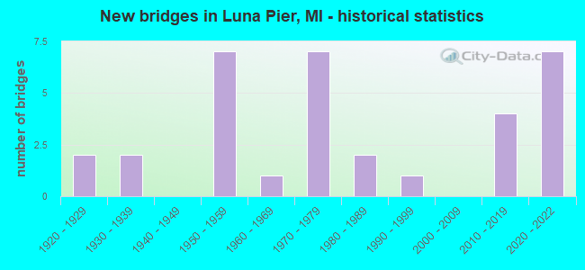
- New bridges - historical statistics
- 21920-1929
- 21930-1939
- 71950-1959
- 11960-1969
- 71970-1979
- 21980-1989
- 11990-1999
- 42010-2019
- 72020-2022
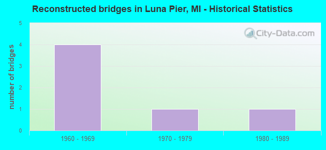
- Reconstructed bridges - Historical Statistics
- 41960-1969
- 11970-1979
- 11980-1989
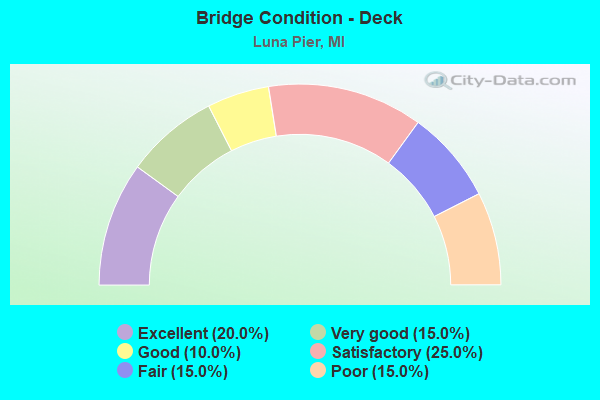
- Bridge Condition - Deck
- 20.0%Excellent
- 15.0%Very good
- 10.0%Good
- 25.0%Satisfactory
- 15.0%Fair
- 15.0%Poor
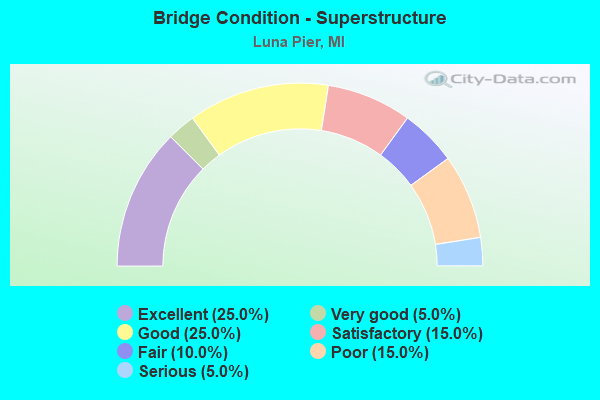
- Bridge Condition - Superstructure
- 25.0%Excellent
- 5.0%Very good
- 25.0%Good
- 15.0%Satisfactory
- 10.0%Fair
- 15.0%Poor
- 5.0%Serious
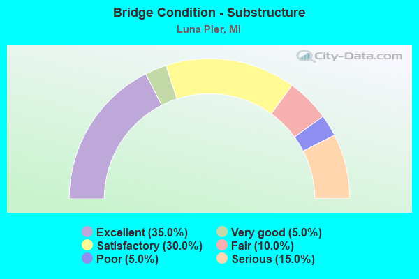
- Bridge Condition - Substructure
- 35.0%Excellent
- 5.0%Very good
- 30.0%Satisfactory
- 10.0%Fair
- 5.0%Poor
- 15.0%Serious
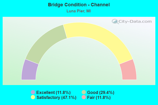
- Bridge Condition - Channel
- 11.8%Excellent
- 29.4%Good
- 47.1%Satisfactory
- 11.8%Fair
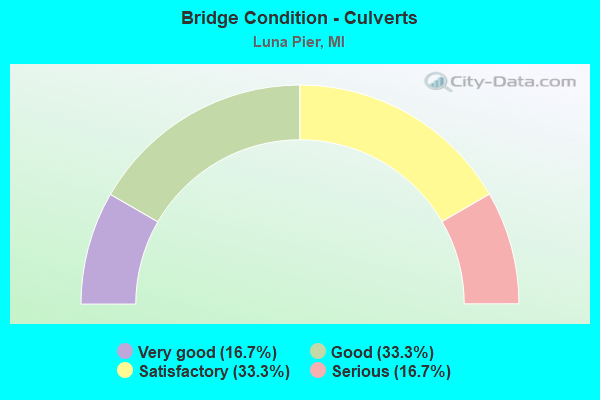
- Bridge Condition - Culverts
- 16.7%Very good
- 33.3%Good
- 33.3%Satisfactory
- 16.7%Serious
Find on map >> Show street view
Structure Number: 3016, Location: SEC 14 MARENISCO TWP (Lat: 46.380817, Lng: -89.774722), Route carried "on" structure: County highway , Year Built: 1990, Status: Open, Structure Length: 0.67m (2.20ft), Average Daily Traffic: 120 (year 1998), Average Future Daily Traffic: 130 (year 2018), Design Load: HS 20, Features Intersected: LITTLE PRESQUE ISLE RIV, Facility Carried by Structure: DUNHAM ROAD
Minimum Vertical Clearance: 30.48m (100.00ft), Kilometerpoint: 0.428, Lanes on structure: 2, Owner: County Highway Agency, Approaching Roadway Width: 7.3m (24.0ft), Skew: 3 degrees, Material/Design: Concrete, Design/Construction: Culvert, Number Of Spans In Main Unit: 2, Length of Maximum Span: 3.0m (9.8ft)
Condition: Channel: Good, Culverts: Good, Operating Rating: 36.4 metric tons, Method Used To Determine Operating Rating: Allowable Stress (AS), Inventory Rating: 35.0 metric tons, Method Used To Determine Inventory Rating: Allowable Stress (AS), Structural Evaluation: Better than present minimum criteria, Waterway Adequacy: Better than present minimum criteria, Approach Roadway Alignment: Better than present minimum criteria, Length Of Structure Improvement: 0.80m (2.62ft), Designated Inspection Frequency: Every 24 months, Inspection Date: September 2020, Bridge Improvement Cost: $112,000, Roadway Improvement Cost: $11,000, Total Project Cost: $154,000
Find on map >> Show street view
Structure Number: 3256, Location: CITY OF ST LOUIS (Lat: 43.413269, Lng: -84.608764), Route carried "on" structure: Business City street 2033, Year Built: 1979, Status: Open, Structure Length: 5.30m (17.39ft), Average Daily Traffic: 2,700 (year 2014), Truck Traffic: 5%, Average Future Daily Traffic: 4,875 (year 2034), Design Load: HS 20+Mod, Features Intersected: PINE RIVER, Facility Carried by Structure: MILL STREET
Minimum Vertical Clearance: 30.48m (100.00ft), Kilometerpoint: 5.477, Lanes on structure: 2, Owner: City or Municipal Highway Agency, Approaching Roadway Width: 8.5m (27.9ft), Material/Design: Prestressed concrete, Design/Construction: Box Beam or Girders - Multiple, Number Of Spans In Main Unit: 3, Length of Maximum Span: 17.4m (57.1ft), Curb or Sidewalk Widths: Left: 1.5m (4.9ft), Right: 1.5m (4.9ft), Curb-To-Curb Width: 7.9m (25.9ft), Out-to-Out Width: 11.7m (38.4ft)
Condition: Deck: Good, Superstructure: Good, Substructure: Very good, Channel: Satisfactory, Operating Rating: 89.7 metric tons, Method Used To Determine Operating Rating: Load Factor (LF) rating reported by rating factor (RF) method using MS18 loading, Inventory Rating: 53.8 metric tons, Method Used To Determine Inventory Rating: Load Factor (LF) rating reported by rating factor (RF) method using MS18 loading, Structural Evaluation: Better than present minimum criteria, Deck Geometry: High priority of corrective action, Waterway Adequacy: Better than present minimum criteria, Approach Roadway Alignment: Equal to present desirable criteria, Length Of Structure Improvement: 5.30m (17.39ft), Designated Inspection Frequency: Every 24 months, Inspection Date: June 2020, Bridge Improvement Cost: $178,000, Roadway Improvement Cost: $115,000, Total Project Cost: $348,000, Deck Structure Type: Concrete Precast Panels, Wearing Surface/Protective System: Wearing Surface: Bituminous, Membrane: Preformed Fabric
Find on map >> Show street view
Structure Number: 6581, Location: IN VILLAGE OF GWINN (Lat: 46.278094, Lng: -87.443400), Route carried "on" structure: County highway , Year Built: 1925, Year Reconstructed: 1985, Status: Open, Structure Length: 1.89m (6.20ft), Average Daily Traffic: 40 (year 2001), Average Future Daily Traffic: 40 (year 2020), Design Load: HS 20+Mod, Features Intersected: E BRANCH ESCANABA RIVER, Facility Carried by Structure: EYZ ROAD
Minimum Vertical Clearance: 30.48m (100.00ft), Kilometerpoint: 0.027, Lanes on structure: 2, Owner: County Highway Agency, Approaching Roadway Width: 7.3m (24.0ft), Material/Design: Steel, Design/Construction: Stringer/Multi-beam, Number Of Spans In Main Unit: 1, Length of Maximum Span: 18.9m (62.0ft), Curb-To-Curb Width: 7.3m (24.0ft), Out-to-Out Width: 7.3m (24.0ft)
Condition: Deck: Satisfactory, Superstructure: Satisfactory, Substructure: Serious, Channel: Satisfactory, Operating Rating: 62.9 metric tons, Method Used To Determine Operating Rating: Load Factor (LF) rating reported by rating factor (RF) method using MS18 loading, Inventory Rating: 37.6 metric tons, Method Used To Determine Inventory Rating: Load Factor (LF) rating reported by rating factor (RF) method using MS18 loading, Structural Evaluation: High priority of corrective action, Deck Geometry: Equal to present minimum criteria, Waterway Adequacy: Better than present minimum criteria, Approach Roadway Alignment: Equal to present minimum criteria, Designated Inspection Frequency: Every 12 months, Inspection Date: October 2021, Deck Structure Type: Open Grating, Wearing Surface/Protective System: Wearing Surface: Other, Deck Protection: Epoxy Coated Reinforcing
Find on map >> Show street view
Structure Number: 7154, Location: 3.0 MI N OHIO STATE LINE (Lat: 41.773461, Lng: -83.486689), Route carried "on" structure: Ramp Interstate 75, Year Built: 1938, Status: Posted for load, Structure Length: 9.14m (29.99ft), Average Daily Traffic: 3,200 (year 2013), Truck Traffic: 8%, Average Future Daily Traffic: 7,360 (year 2033), Design Load: HS 20, Features Intersected: NS & GTW RR
Minimum Vertical Clearance: 30.48m (100.00ft), Kilometerpoint: 1.429, Lanes on structure: 4, Owner: State Highway Agency, Approaching Roadway Width: 21.3m (69.9ft), Skew: 32 degrees, Material/Design: Steel, Design/Construction: Stringer/Multi-beam, Number Of Spans In Main Unit: 7, Length of Maximum Span: 16.4m (53.8ft), Curb-To-Curb Width: 16.0m (52.5ft), Out-to-Out Width: 16.5m (54.1ft)
Condition: Deck: Poor, Superstructure: Serious, Substructure: Serious, Operating Rating: 37.3 metric tons, Method Used To Determine Operating Rating: Load Factor (LF) rating reported by rating factor (RF) method using MS18 loading, Inventory Rating: 22.4 metric tons, Method Used To Determine Inventory Rating: Load Factor (LF) rating reported by rating factor (RF) method using MS18 loading, Structural Evaluation: High priority of corrective action, Deck Geometry: Meets minimum limits, Approach Roadway Alignment: Equal to present desirable criteria, Bridge Posting: Required (Relationship of Operating Rating to Maximum Legal Load: 20.0 - 29.9% below), Designated Inspection Frequency: Every 12 months, Inspection Date: March 2021, Deck Structure Type: Concrete Cast-file-Place, Wearing Surface/Protective System: Wearing Surface: Monolithic Concrete
Find on map >> Show street view
Structure Number: 7158, Location: 4.2 MI NE OHIO STATE LINE (Lat: 41.788814, Lng: -83.466325), Route carried "on" structure: Interstate 75, Year Built: 2019, Status: Open, Structure Length: 1.83m (6.00ft), Average Daily Traffic: 27,575 (year 2015), Truck Traffic: 29%, Average Future Daily Traffic: 30,773 (year 2036), Design Load: Greater than HL93, Features Intersected: BAY CREEK
Minimum Vertical Clearance: 30.48m (100.00ft), Kilometerpoint: 6.697, Lanes on structure: 3, Base Highway Network: Yes (Inventory Route: 122, Subroute: 10), Owner: State Highway Agency, Approaching Roadway Width: 18.4m (60.4ft), Skew: 1 degrees, Material/Design: Prestressed concrete, Design/Construction: Stringer/Multi-beam, Number Of Spans In Main Unit: 1, Length of Maximum Span: 17.5m (57.4ft), Curb-To-Curb Width: 18.4m (60.4ft), Out-to-Out Width: 19.4m (63.6ft)
Condition: Deck: Excellent, Superstructure: Excellent, Substructure: Excellent, Channel: Excellent, Operating Rating: 63.8 metric tons, Method Used To Determine Operating Rating: Load and Resistance Factor Rating (LRFR) rating reported by rating factor(RF) method using HL-93 loadings, Inventory Rating: 43.1 metric tons, Method Used To Determine Inventory Rating: Load and Resistance Factor Rating (LRFR) rating reported by rating factor(RF) method using HL-93 loadings, Structural Evaluation: Superior to present desirable criteria, Deck Geometry: Equal to present desirable criteria, Waterway Adequacy: Equal to present desirable criteria, Approach Roadway Alignment: Equal to present desirable criteria, Designated Inspection Frequency: Every 24 months, Inspection Date: June 2021, Deck Structure Type: Concrete Cast-file-Place, Wearing Surface/Protective System: Wearing Surface: Monolithic Concrete, Deck Protection: Epoxy Coated Reinforcing
Find on map >> Show street view
Structure Number: 7159, Location: 4.2 MI NE OHIO STATE LINE (Lat: 41.788881, Lng: -83.466586), Route carried "on" structure: Interstate 75, Year Built: 2020, Status: Open, Structure Length: 1.83m (6.00ft), Average Daily Traffic: 27,575 (year 2015), Truck Traffic: 29%, Average Future Daily Traffic: 30,773 (year 2036), Design Load: Greater than HL93, Features Intersected: BAY CREEK
Minimum Vertical Clearance: 30.48m (100.00ft), Kilometerpoint: 6.693, Lanes on structure: 3, Base Highway Network: Yes (Inventory Route: 122, Subroute: 9), Owner: State Highway Agency, Approaching Roadway Width: 18.4m (60.4ft), Skew: 1 degrees, Material/Design: Prestressed concrete, Design/Construction: Stringer/Multi-beam, Number Of Spans In Main Unit: 1, Length of Maximum Span: 17.5m (57.4ft), Curb-To-Curb Width: 18.4m (60.4ft), Out-to-Out Width: 19.4m (63.6ft)
Condition: Deck: Excellent, Superstructure: Excellent, Substructure: Excellent, Channel: Excellent, Operating Rating: 63.5 metric tons, Method Used To Determine Operating Rating: Load and Resistance Factor Rating (LRFR) rating reported by rating factor(RF) method using HL-93 loadings, Inventory Rating: 42.8 metric tons, Method Used To Determine Inventory Rating: Load and Resistance Factor Rating (LRFR) rating reported by rating factor(RF) method using HL-93 loadings, Structural Evaluation: Superior to present desirable criteria, Deck Geometry: Equal to present desirable criteria, Waterway Adequacy: Equal to present desirable criteria, Approach Roadway Alignment: Equal to present minimum criteria, Designated Inspection Frequency: Every 24 months, Inspection Date: June 2021, Deck Structure Type: Concrete Cast-file-Place, Wearing Surface/Protective System: Wearing Surface: Monolithic Concrete, Deck Protection: Epoxy Coated Reinforcing
Find on map >> Show street view
Structure Number: 716, Location: 7.7 MI NE OHIO STATE LINE (Lat: 41.831881, Lng: -83.427808), Route carried "on" structure: Interstate 75, Year Built: 1954, Year Reconstructed: 1974, Status: Open, Structure Length: 1.37m (4.49ft), Average Daily Traffic: 30,215 (year 2007), Truck Traffic: 24%, Average Future Daily Traffic: 33,544 (year 2018), Design Load: HS 20, Features Intersected: MUDDY CREEK
Minimum Vertical Clearance: 30.48m (100.00ft), Kilometerpoint: 12.466, Lanes on structure: 4, Base Highway Network: Yes (Inventory Route: 122, Subroute: 10), Owner: State Highway Agency, Approaching Roadway Width: 18.6m (61.0ft), Skew: 13 degrees, Material/Design: Steel, Design/Construction: Stringer/Multi-beam, Number Of Spans In Main Unit: 1, Length of Maximum Span: 13.7m (44.9ft), Curb-To-Curb Width: 19.1m (62.7ft), Out-to-Out Width: 19.6m (64.3ft)
Condition: Deck: Satisfactory, Superstructure: Good, Substructure: Satisfactory, Channel: Good, Operating Rating: 75.2 metric tons, Method Used To Determine Operating Rating: Load Factor (LF) rating reported by rating factor (RF) method using MS18 loading, Inventory Rating: 45.0 metric tons, Method Used To Determine Inventory Rating: Load Factor (LF) rating reported by rating factor (RF) method using MS18 loading, Structural Evaluation: Equal to present minimum criteria, Deck Geometry: Somewhat better than minimum adequacy, Waterway Adequacy: Equal to present desirable criteria, Approach Roadway Alignment: Equal to present minimum criteria, Designated Inspection Frequency: Every 24 months, Inspection Date: June 2021, Deck Structure Type: Concrete Cast-file-Place, Wearing Surface/Protective System: Wearing Surface: Latex Concrete
Find on map >> Show street view
Structure Number: 7161, Location: 7.7 MI NE OHIO STATE LINE (Lat: 41.831875, Lng: -83.428150), Route carried "on" structure: Interstate 75, Year Built: 1954, Year Reconstructed: 1974, Status: Open, Structure Length: 1.37m (4.49ft), Average Daily Traffic: 30,215 (year 2007), Truck Traffic: 24%, Average Future Daily Traffic: 33,544 (year 2018), Design Load: HS 20, Features Intersected: MUDDY CREEK
Minimum Vertical Clearance: 30.48m (100.00ft), Kilometerpoint: 12.454, Lanes on structure: 4, Base Highway Network: Yes (Inventory Route: 122, Subroute: 9), Owner: State Highway Agency, Approaching Roadway Width: 18.6m (61.0ft), Skew: 13 degrees, Material/Design: Steel, Design/Construction: Stringer/Multi-beam, Number Of Spans In Main Unit: 1, Length of Maximum Span: 13.7m (44.9ft), Curb-To-Curb Width: 19.1m (62.7ft), Out-to-Out Width: 19.6m (64.3ft)
Condition: Deck: Satisfactory, Superstructure: Good, Substructure: Satisfactory, Channel: Good, Operating Rating: 75.2 metric tons, Method Used To Determine Operating Rating: Load Factor (LF) rating reported by rating factor (RF) method using MS18 loading, Inventory Rating: 45.0 metric tons, Method Used To Determine Inventory Rating: Load Factor (LF) rating reported by rating factor (RF) method using MS18 loading, Structural Evaluation: Equal to present minimum criteria, Deck Geometry: Somewhat better than minimum adequacy, Waterway Adequacy: Equal to present desirable criteria, Approach Roadway Alignment: Equal to present minimum criteria, Designated Inspection Frequency: Every 24 months, Inspection Date: June 2021, Deck Structure Type: Concrete Cast-file-Place, Wearing Surface/Protective System: Wearing Surface: Latex Concrete
Find on map >> Show street view
Structure Number: 7162, Location: 8.7 MI NE OHIO STATE LINE (Lat: 41.844092, Lng: -83.419483), Route carried "on" structure: Interstate 75, Year Built: 1955, Year Reconstructed: 1974, Status: Open, Structure Length: 3.81m (12.50ft), Average Daily Traffic: 30,558 (year 2007), Truck Traffic: 24%, Average Future Daily Traffic: 35,167 (year 2018), Design Load: HS 20, Features Intersected: OTTER CREEK
Minimum Vertical Clearance: 30.48m (100.00ft), Kilometerpoint: 13.989, Lanes on structure: 4, Base Highway Network: Yes (Inventory Route: 122, Subroute: 10), Owner: State Highway Agency, Approaching Roadway Width: 18.6m (61.0ft), Skew: 10 degrees, Material/Design: Steel continuous, Design/Construction: Stringer/Multi-beam, Number Of Spans In Main Unit: 3, Length of Maximum Span: 13.7m (44.9ft), Curb-To-Curb Width: 19.1m (62.7ft), Out-to-Out Width: 19.6m (64.3ft)
Condition: Deck: Poor, Superstructure: Fair, Substructure: Fair, Channel: Satisfactory, Operating Rating: 70.3 metric tons, Method Used To Determine Operating Rating: Load Factor (LF) rating reported by rating factor (RF) method using MS18 loading, Inventory Rating: 42.1 metric tons, Method Used To Determine Inventory Rating: Load Factor (LF) rating reported by rating factor (RF) method using MS18 loading, Structural Evaluation: Somewhat better than minimum adequacy, Deck Geometry: Somewhat better than minimum adequacy, Waterway Adequacy: Equal to present minimum criteria, Approach Roadway Alignment: Equal to present desirable criteria, Designated Inspection Frequency: Every 12 months, Other Special Inspection Frequency: Every 12 months, Inspection Date: June 2021, Other Special Inspection Date: December 2021, Bridge Improvement Cost: $29,000, Deck Structure Type: Concrete Cast-file-Place, Wearing Surface/Protective System: Wearing Surface: Latex Concrete
Find on map >> Show street view
Structure Number: 7163, Location: 8.7 MI NE OHIO STATE LINE (Lat: 41.844186, Lng: -83.419761), Route carried "on" structure: Interstate 75, Year Built: 1955, Year Reconstructed: 1974, Status: Open, Structure Length: 3.81m (12.50ft), Average Daily Traffic: 30,558 (year 2007), Truck Traffic: 24%, Average Future Daily Traffic: 35,167 (year 2018), Design Load: HS 20, Features Intersected: OTTER CREEK
Minimum Vertical Clearance: 30.48m (100.00ft), Kilometerpoint: 13.989, Lanes on structure: 4, Base Highway Network: Yes (Inventory Route: 122, Subroute: 9), Owner: State Highway Agency, Approaching Roadway Width: 18.6m (61.0ft), Skew: 10 degrees, Material/Design: Steel continuous, Design/Construction: Stringer/Multi-beam, Number Of Spans In Main Unit: 3, Length of Maximum Span: 13.7m (44.9ft), Curb-To-Curb Width: 19.1m (62.7ft), Out-to-Out Width: 19.6m (64.3ft)
Condition: Deck: Poor, Superstructure: Fair, Substructure: Fair, Channel: Satisfactory, Operating Rating: 70.3 metric tons, Method Used To Determine Operating Rating: Load Factor (LF) rating reported by rating factor (RF) method using MS18 loading, Inventory Rating: 42.1 metric tons, Method Used To Determine Inventory Rating: Load Factor (LF) rating reported by rating factor (RF) method using MS18 loading, Structural Evaluation: Somewhat better than minimum adequacy, Deck Geometry: Somewhat better than minimum adequacy, Waterway Adequacy: Equal to present minimum criteria, Approach Roadway Alignment: Equal to present minimum criteria, Designated Inspection Frequency: Every 12 months, Other Special Inspection Frequency: Every 12 months, Inspection Date: June 2021, Other Special Inspection Date: December 2021, Deck Structure Type: Concrete Cast-file-Place, Wearing Surface/Protective System: Wearing Surface: Latex Concrete
Find on map >> Show street view
Structure Number: 717, Location: 3.5 MI NE OHIO STATE LINE (Lat: 41.779925, Lng: -83.473286), Route carried "on" structure: Interstate 75, Year Built: 2019, Status: Open, Structure Length: 4.08m (13.39ft), Average Daily Traffic: 27,575 (year 2015), Truck Traffic: 29%, Average Future Daily Traffic: 30,773 (year 2036), Design Load: Greater than HL93, Features Intersected: GTW RR
Minimum Vertical Clearance: 30.48m (100.00ft), Kilometerpoint: 5.552, Lanes on structure: 3, Base Highway Network: Yes (Inventory Route: 122, Subroute: 10), Owner: State Highway Agency, Approaching Roadway Width: 18.4m (60.4ft), Skew: 3 degrees, Material/Design: Steel, Design/Construction: Stringer/Multi-beam, Number Of Spans In Main Unit: 1, Length of Maximum Span: 39.6m (129.9ft), Curb-To-Curb Width: 18.4m (60.4ft), Out-to-Out Width: 19.4m (63.6ft)
Condition: Deck: Very good, Superstructure: Very good, Substructure: Excellent, Operating Rating: 51.2 metric tons, Method Used To Determine Operating Rating: Load and Resistance Factor Rating (LRFR) rating reported by rating factor(RF) method using HL-93 loadings, Inventory Rating: 39.5 metric tons, Method Used To Determine Inventory Rating: Load and Resistance Factor Rating (LRFR) rating reported by rating factor(RF) method using HL-93 loadings, Structural Evaluation: Equal to present desirable criteria, Deck Geometry: Equal to present desirable criteria, Approach Roadway Alignment: Equal to present minimum criteria, Length Of Structure Improvement: 5.64m (18.50ft), Designated Inspection Frequency: Every 24 months, Inspection Date: June 2021, Bridge Improvement Cost: $154,000, Roadway Improvement Cost: $6,000, Total Project Cost: $67,000, Deck Structure Type: Concrete Cast-file-Place, Wearing Surface/Protective System: Wearing Surface: Monolithic Concrete, Deck Protection: Epoxy Coated Reinforcing
Find on map >> Show street view
Structure Number: 7171, Location: 3.5 MI NE OHIO STATE LINE (Lat: 41.779906, Lng: -83.473622), Route carried "on" structure: Interstate 75, Year Built: 2020, Status: Open, Structure Length: 4.08m (13.39ft), Average Daily Traffic: 27,575 (year 2015), Truck Traffic: 29%, Average Future Daily Traffic: 30,773 (year 2036), Design Load: Greater than HL93, Features Intersected: GTW RR
Minimum Vertical Clearance: 30.48m (100.00ft), Kilometerpoint: 5.540, Lanes on structure: 3, Base Highway Network: Yes (Inventory Route: 122, Subroute: 9), Owner: State Highway Agency, Approaching Roadway Width: 18.4m (60.4ft), Skew: 3 degrees, Material/Design: Steel, Design/Construction: Stringer/Multi-beam, Number Of Spans In Main Unit: 1, Length of Maximum Span: 39.6m (129.9ft), Curb-To-Curb Width: 18.4m (60.4ft), Out-to-Out Width: 19.4m (63.6ft)
Condition: Deck: Very good, Superstructure: Excellent, Substructure: Excellent, Operating Rating: 50.9 metric tons, Method Used To Determine Operating Rating: Load and Resistance Factor Rating (LRFR) rating reported by rating factor(RF) method using HL-93 loadings, Inventory Rating: 39.2 metric tons, Method Used To Determine Inventory Rating: Load and Resistance Factor Rating (LRFR) rating reported by rating factor(RF) method using HL-93 loadings, Structural Evaluation: Superior to present desirable criteria, Deck Geometry: Equal to present desirable criteria, Approach Roadway Alignment: Equal to present minimum criteria, Length Of Structure Improvement: 5.64m (18.50ft), Designated Inspection Frequency: Every 24 months, Inspection Date: June 2021, Bridge Improvement Cost: $154,000, Roadway Improvement Cost: $6,000, Total Project Cost: $67,000, Deck Structure Type: Concrete Cast-file-Place, Wearing Surface/Protective System: Wearing Surface: Monolithic Concrete, Deck Protection: Epoxy Coated Reinforcing
Find on map >> Show street view
Structure Number: 7176, Location: 3.6 MI NE OHIO STATE LINE (Lat: 41.781181, Lng: -83.472297), Route carried "on" structure: Interstate 75, Year Built: 2019, Status: Open, Structure Length: 3.47m (11.38ft), Average Daily Traffic: 27,575 (year 2015), Truck Traffic: 29%, Average Future Daily Traffic: 30,773 (year 2036), Design Load: Greater than HL93, Features Intersected: BAY CREEK RD
Minimum Vertical Clearance: 30.48m (100.00ft), Kilometerpoint: 5.715, Lanes on structure: 3, Lanes under structure: 2, Base Highway Network: Yes (Inventory Route: 122, Subroute: 10), Owner: State Highway Agency, Approaching Roadway Width: 18.4m (60.4ft), Material/Design: Prestressed concrete, Design/Construction: Stringer/Multi-beam, Number Of Spans In Main Unit: 1, Length of Maximum Span: 33.9m (111.2ft), Curb-To-Curb Width: 18.4m (60.4ft), Out-to-Out Width: 19.4m (63.6ft)
Condition: Deck: Excellent, Superstructure: Excellent, Substructure: Excellent, Operating Rating: 64.2 metric tons, Method Used To Determine Operating Rating: Load and Resistance Factor Rating (LRFR) rating reported by rating factor(RF) method using HL-93 loadings, Inventory Rating: 47.6 metric tons, Method Used To Determine Inventory Rating: Load and Resistance Factor Rating (LRFR) rating reported by rating factor(RF) method using HL-93 loadings, Structural Evaluation: Superior to present desirable criteria, Deck Geometry: Equal to present desirable criteria, Underclear: Meets minimum limits, Approach Roadway Alignment: Equal to present minimum criteria, Designated Inspection Frequency: Every 24 months, Inspection Date: June 2021, Total Project Cost: $4,000, Deck Structure Type: Concrete Cast-file-Place, Wearing Surface/Protective System: Wearing Surface: Monolithic Concrete, Deck Protection: Epoxy Coated Reinforcing
Find on map >> Show street view
Structure Number: 7177, Location: 3.6 MI NE OHIO STATE LINE (Lat: 41.781289, Lng: -83.472542), Route carried "on" structure: Interstate 75, Year Built: 2020, Status: Open, Structure Length: 3.47m (11.38ft), Average Daily Traffic: 27,575 (year 2015), Truck Traffic: 29%, Average Future Daily Traffic: 30,773 (year 2036), Design Load: Greater than HL93, Features Intersected: BAY CREEK RD
Minimum Vertical Clearance: 30.48m (100.00ft), Kilometerpoint: 5.717, Lanes on structure: 3, Lanes under structure: 2, Base Highway Network: Yes (Inventory Route: 122, Subroute: 9), Owner: State Highway Agency, Approaching Roadway Width: 18.4m (60.4ft), Material/Design: Prestressed concrete, Design/Construction: Stringer/Multi-beam, Number Of Spans In Main Unit: 1, Length of Maximum Span: 33.9m (111.2ft), Curb-To-Curb Width: 18.4m (60.4ft), Out-to-Out Width: 19.4m (63.6ft)
Condition: Deck: Excellent, Superstructure: Good, Substructure: Excellent, Operating Rating: 61.6 metric tons, Method Used To Determine Operating Rating: Load and Resistance Factor Rating (LRFR) rating reported by rating factor(RF) method using HL-93 loadings, Inventory Rating: 48.0 metric tons, Method Used To Determine Inventory Rating: Load and Resistance Factor Rating (LRFR) rating reported by rating factor(RF) method using HL-93 loadings, Structural Evaluation: Better than present minimum criteria, Deck Geometry: Equal to present desirable criteria, Underclear: High priority of corrective action, Approach Roadway Alignment: Equal to present minimum criteria, Designated Inspection Frequency: Every 24 months, Inspection Date: June 2021, Bridge Improvement Cost: $97,000, Deck Structure Type: Concrete Cast-file-Place, Wearing Surface/Protective System: Wearing Surface: Monolithic Concrete, Deck Protection: Epoxy Coated Reinforcing
Find on map >> Show street view
Structure Number: 7178, Location: 4.7 MI NE OHIO STATE LINE (Lat: 41.794436, Lng: -83.461925), Route carried "on" structure: County highway , Year Built: 2020, Status: Open, Structure Length: 7.01m (23.00ft), Average Daily Traffic: 1,127 (year 2015), Truck Traffic: 3%, Average Future Daily Traffic: 1,252 (year 2036), Design Load: Greater than HL93, Features Intersected: I-75, Facility Carried by Structure: ERIE RD
Minimum Vertical Clearance: 30.48m (100.00ft), Kilometerpoint: 19.182, Lanes on structure: 2, Lanes under structure: 6, Base Highway Network: Yes (Inventory Route: 123, Subroute: 7), Owner: State Highway Agency, Approaching Roadway Width: 12.2m (40.0ft), Skew: 3 degrees, Material/Design: Steel continuous, Design/Construction: Stringer/Multi-beam, Number Of Spans In Main Unit: 2, Length of Maximum Span: 34.5m (113.2ft), Curb-To-Curb Width: 12.2m (40.0ft), Out-to-Out Width: 13.3m (43.6ft)
Condition: Deck: Very good, Superstructure: Excellent, Substructure: Excellent, Operating Rating: 49.6 metric tons, Method Used To Determine Operating Rating: Load and Resistance Factor Rating (LRFR) rating reported by rating factor(RF) method using HL-93 loadings, Inventory Rating: 38.2 metric tons, Method Used To Determine Inventory Rating: Load and Resistance Factor Rating (LRFR) rating reported by rating factor(RF) method using HL-93 loadings, Structural Evaluation: Superior to present desirable criteria, Deck Geometry: Better than present minimum criteria, Underclear: Somewhat better than minimum adequacy, Approach Roadway Alignment: Equal to present desirable criteria, Length Of Structure Improvement: 7.90m (25.92ft), Designated Inspection Frequency: Every 24 months, Inspection Date: June 2021, Bridge Improvement Cost: $90,000, Roadway Improvement Cost: $9,000, Total Project Cost: $106,000, Deck Structure Type: Concrete Cast-file-Place, Wearing Surface/Protective System: Wearing Surface: Monolithic Concrete, Deck Protection: Epoxy Coated Reinforcing
Find on map >> Show street view
Structure Number: 7179, Location: 5.8 MI NE OHIO STATE LINE (Lat: 41.809119, Lng: -83.450433), Route carried "on" structure: County highway 5820, Year Built: 1956, Status: Posted for load, Structure Length: 7.89m (25.89ft), Average Daily Traffic: 4,360 (year 1974), Truck Traffic: 3%, Average Future Daily Traffic: 4,360 (year 1977), Design Load: HS 15, Features Intersected: I-75, Facility Carried by Structure: LUNA PIER RD
Minimum Vertical Clearance: 30.48m (100.00ft), Kilometerpoint: 19.659, Lanes on structure: 2, Lanes under structure: 6, Base Highway Network: Yes (Inventory Route: 122, Subroute: 10), Owner: State Highway Agency, Approaching Roadway Width: 10.6m (34.8ft), Skew: 3 degrees, Material/Design: Concrete continuous, Design/Construction: Tee Beam, Number Of Spans In Main Unit: 4, Length of Maximum Span: 23.4m (76.8ft), Curb or Sidewalk Widths: Left: 0.4m (1.3ft), Right: 0.4m (1.3ft), Curb-To-Curb Width: 7.9m (25.9ft), Out-to-Out Width: 9.5m (31.2ft)
Condition: Deck: Fair, Superstructure: Poor, Substructure: Satisfactory, Operating Rating: 49.2 metric tons, Method Used To Determine Operating Rating: Load Factor (LF) rating reported by rating factor (RF) method using MS18 loading, Inventory Rating: 29.5 metric tons, Method Used To Determine Inventory Rating: Load Factor (LF) rating reported by rating factor (RF) method using MS18 loading, Structural Evaluation: Meets minimum limits, Deck Geometry: High priority of corrective action, Underclear: High priority of corrective action, Approach Roadway Alignment: Equal to present desirable criteria, Bridge Posting: Required (Relationship of Operating Rating to Maximum Legal Load: 0.1 - 9.9% below), Designated Inspection Frequency: Every 24 months, Other Special Inspection Frequency: Every 24 months, Inspection Date: June 2021, Other Special Inspection Date: June 2020, Deck Structure Type: Concrete Cast-file-Place, Wearing Surface/Protective System: Wearing Surface: Latex Concrete
Find on map >> Show street view
Structure Number: 718, Location: 5.7 MI SW OF MONROE (Lat: 41.823567, Lng: -83.435606), Route carried "on" structure: County highway , Year Built: 1974, Status: Open, Structure Length: 7.50m (24.61ft), Average Daily Traffic: 170 (year 1974), Average Future Daily Traffic: 170 (year 1977), Design Load: H 20, Features Intersected: I-75, Facility Carried by Structure: GAYNIER RD
Minimum Vertical Clearance: 30.48m (100.00ft), Kilometerpoint: 0.568, Lanes on structure: 2, Lanes under structure: 8, Owner: State Highway Agency, Approaching Roadway Width: 10.9m (35.8ft), Material/Design: Steel, Design/Construction: Stringer/Multi-beam, Number Of Spans In Main Unit: 2, Length of Maximum Span: 40.2m (131.9ft), Curb or Sidewalk Widths: Left: 0.2m (0.7ft), Right: 0.2m (0.7ft), Curb-To-Curb Width: 11.2m (36.7ft), Out-to-Out Width: 12.0m (39.4ft)
Condition: Deck: Satisfactory, Superstructure: Satisfactory, Substructure: Satisfactory, Operating Rating: 83.3 metric tons, Method Used To Determine Operating Rating: Load Factor (LF) rating reported by rating factor (RF) method using MS18 loading, Inventory Rating: 49.6 metric tons, Method Used To Determine Inventory Rating: Load Factor (LF) rating reported by rating factor (RF) method using MS18 loading, Structural Evaluation: Equal to present minimum criteria, Deck Geometry: Superior to present desirable criteria, Underclear: Somewhat better than minimum adequacy, Approach Roadway Alignment: Equal to present minimum criteria, Designated Inspection Frequency: Every 24 months, Inspection Date: June 2021, Deck Structure Type: Concrete Cast-file-Place, Wearing Surface/Protective System: Wearing Surface: Epoxy Overlay
Find on map >> Show street view
Structure Number: 7181, Location: 4.0 MI SW OF MONROE (Lat: 41.843281, Lng: -83.420028), Route carried "on" structure: County highway 5830, Year Built: 1974, Status: Open, Structure Length: 6.98m (22.90ft), Average Daily Traffic: 1,270 (year 1974), Average Future Daily Traffic: 1,270 (year 1977), Design Load: HS 20, Features Intersected: I-75, Facility Carried by Structure: OTTER CREEK RD
Minimum Vertical Clearance: 30.48m (100.00ft), Kilometerpoint: 3.798, Lanes on structure: 2, Lanes under structure: 8, Owner: State Highway Agency, Approaching Roadway Width: 11.5m (37.7ft), Material/Design: Steel, Design/Construction: Stringer/Multi-beam, Number Of Spans In Main Unit: 2, Length of Maximum Span: 35.6m (116.8ft), Curb-To-Curb Width: 12.8m (42.0ft), Out-to-Out Width: 13.5m (44.3ft)
Condition: Deck: Fair, Superstructure: Satisfactory, Substructure: Satisfactory, Operating Rating: 66.7 metric tons, Method Used To Determine Operating Rating: Load Factor (LF) rating reported by rating factor (RF) method using MS18 loading, Inventory Rating: 39.9 metric tons, Method Used To Determine Inventory Rating: Load Factor (LF) rating reported by rating factor (RF) method using MS18 loading, Structural Evaluation: Equal to present minimum criteria, Deck Geometry: Better than present minimum criteria, Underclear: Somewhat better than minimum adequacy, Approach Roadway Alignment: Equal to present desirable criteria, Designated Inspection Frequency: Every 24 months, Inspection Date: June 2021, Deck Structure Type: Concrete Cast-file-Place, Wearing Surface/Protective System: Wearing Surface: Monolithic Concrete
Find on map >> Show street view
Structure Number: 7241, Location: 1.3 MI N OF VICTORY RD (Lat: 41.834736, Lng: -83.435342), Route carried "on" structure: County highway , Year Built: 1927, Year Reconstructed: 1977, Status: Open, Structure Length: 1.06m (3.48ft), Average Daily Traffic: 380 (year 2015), Truck Traffic: 2%, Average Future Daily Traffic: 437 (year 2035), Design Load: HS 20, Features Intersected: MUDDY CREEK, Facility Carried by Structure: COUSINO RD
Minimum Vertical Clearance: 30.48m (100.00ft), Kilometerpoint: 28.163, Lanes on structure: 2, Owner: County Highway Agency, Approaching Roadway Width: 8.5m (27.9ft), Material/Design: Prestressed concrete, Design/Construction: Box Beam or Girders - Multiple, Number Of Spans In Main Unit: 1, Length of Maximum Span: 10.0m (32.8ft), Curb-To-Curb Width: 9.4m (30.8ft), Out-to-Out Width: 10.1m (33.1ft)
Condition: Deck: Good, Superstructure: Good, Substructure: Satisfactory, Channel: Good, Inventory Rating: 50.9 metric tons, Method Used To Determine Inventory Rating: Allowable Stress (AS), Structural Evaluation: Equal to present minimum criteria, Deck Geometry: Equal to present minimum criteria, Waterway Adequacy: Equal to present desirable criteria, Approach Roadway Alignment: Meets minimum limits, Designated Inspection Frequency: Every 24 months, Inspection Date: October 2020, Deck Structure Type: Concrete Precast Panels, Wearing Surface/Protective System: Wearing Surface: Bituminous, Membrane: Other
Find on map >> Show street view
Structure Number: 7242, Location: .05 MI N OF S OTTER CK RD (Lat: 41.850436, Lng: -83.429572), Route carried "on" structure: County highway , Year Built: 1964, Status: Temporarily open, Structure Length: 3.20m (10.50ft), Average Daily Traffic: 360 (year 2017), Truck Traffic: 18%, Average Future Daily Traffic: 414 (year 2037), Design Load: H 20, Features Intersected: OTTER CREEK, Facility Carried by Structure: KNAB RD
Minimum Vertical Clearance: 30.48m (100.00ft), Kilometerpoint: 0.079, Lanes on structure: 2, Owner: County Highway Agency, Approaching Roadway Width: 9.8m (32.2ft), Skew: 1 degrees, Material/Design: Prestressed concrete, Design/Construction: Box Beam or Girders - Multiple, Number Of Spans In Main Unit: 3, Length of Maximum Span: 10.3m (33.8ft), Curb or Sidewalk Widths: Left: 0.4m (1.3ft), Right: 0.4m (1.3ft), Curb-To-Curb Width: 8.6m (28.2ft), Out-to-Out Width: 10.3m (33.8ft)
Condition: Deck: Fair, Superstructure: Poor, Substructure: Poor, Channel: Fair, Operating Rating: 75.5 metric tons, Method Used To Determine Operating Rating: Load Factor (LF) rating reported by rating factor (RF) method using MS18 loading, Inventory Rating: 45.7 metric tons, Method Used To Determine Inventory Rating: Load Factor (LF) rating reported by rating factor (RF) method using MS18 loading, Structural Evaluation: Meets minimum limits, Waterway Adequacy: Equal to present desirable criteria, Approach Roadway Alignment: Equal to present minimum criteria, Designated Inspection Frequency: Every 24 months, Inspection Date: November 2021, Deck Structure Type: Concrete Precast Panels, Wearing Surface/Protective System: Wearing Surface: Monolithic Concrete
Find on map >> Show street view
Structure Number: 7342, Location: 1 MI N OF SUMMIT STREET (Lat: 41.769583, Lng: -83.480058), Route carried "on" structure: County highway , Year Built: 1955, Status: Open, Structure Length: 0.73m (2.40ft), Average Daily Traffic: 140 (year 2012), Truck Traffic: 4%, Average Future Daily Traffic: 161 (year 2032), Design Load: H 20, Features Intersected: LITTLE LAKE CREEK, Facility Carried by Structure: BAY CREEK ROAD
Minimum Vertical Clearance: 30.48m (100.00ft), Kilometerpoint: 1.783, Lanes on structure: 2, Owner: County Highway Agency, Approaching Roadway Width: 9.1m (29.9ft), Skew: 2 degrees, Material/Design: Concrete continuous, Design/Construction: Culvert, Number Of Spans In Main Unit: 2, Length of Maximum Span: 3.2m (10.5ft), Curb-To-Curb Width: 7.3m (24.0ft), Out-to-Out Width: 14.9m (48.9ft)
Condition: Channel: Fair, Culverts: Satisfactory, Operating Rating: 38.6 metric tons, Method Used To Determine Operating Rating: Load Factor (LF) rating reported by rating factor (RF) method using MS18 loading, Inventory Rating: 23.0 metric tons, Method Used To Determine Inventory Rating: Load Factor (LF) rating reported by rating factor (RF) method using MS18 loading, Structural Evaluation: Equal to present minimum criteria, Deck Geometry: Somewhat better than minimum adequacy, Waterway Adequacy: Better than present minimum criteria, Approach Roadway Alignment: Equal to present minimum criteria, Designated Inspection Frequency: Every 24 months, Inspection Date: October 2020, Wearing Surface/Protective System: Wearing Surface: Bituminous
Find on map >> Show street view
Structure Number: 7344, Location: 0.1 MI N OF VIENNA ROAD (Lat: 41.788964, Lng: -83.471581), Route carried "on" structure: County highway , Year Built: 1971, Status: Open, Structure Length: 0.74m (2.43ft), Average Daily Traffic: 220 (year 2016), Truck Traffic: 6%, Average Future Daily Traffic: 253 (year 2036), Design Load: H 15, Features Intersected: BAY CREEK, Facility Carried by Structure: BAY CREEK ROAD
Minimum Vertical Clearance: 30.48m (100.00ft), Kilometerpoint: 4.743, Lanes on structure: 2, Owner: County Highway Agency, Approaching Roadway Width: 5.8m (19.0ft), Material/Design: Steel, Design/Construction: Stringer/Multi-beam, Number Of Spans In Main Unit: 1, Length of Maximum Span: 6.5m (21.3ft), Curb-To-Curb Width: 7.0m (23.0ft), Out-to-Out Width: 7.5m (24.6ft)
Condition: Deck: Satisfactory, Superstructure: Poor, Substructure: Serious, Channel: Satisfactory, Operating Rating: 51.2 metric tons, Method Used To Determine Operating Rating: Load Factor (LF) rating reported by rating factor (RF) method using MS18 loading, Inventory Rating: 30.8 metric tons, Method Used To Determine Inventory Rating: Load Factor (LF) rating reported by rating factor (RF) method using MS18 loading, Structural Evaluation: High priority of corrective action, Deck Geometry: Meets minimum limits, Waterway Adequacy: Equal to present desirable criteria, Approach Roadway Alignment: High priority of corrective action, Designated Inspection Frequency: Every 12 months, Inspection Date: November 2021, Deck Structure Type: Concrete Cast-file-Place, Wearing Surface/Protective System: Wearing Surface: Monolithic Concrete
Find on map >> Show street view
Structure Number: 7363, Location: 0.1 MI W OF COUSINO ROAD (Lat: 41.830161, Lng: -83.446761), Route carried "on" structure: County highway , Year Built: 1986, Status: Posted for load, Structure Length: 0.94m (3.08ft), Average Daily Traffic: 280 (year 2018), Truck Traffic: 19%, Average Future Daily Traffic: 322 (year 2038), Design Load: HS 20, Features Intersected: MUDDY CREEK, Facility Carried by Structure: KELLY ROAD
Minimum Vertical Clearance: 30.48m (100.00ft), Kilometerpoint: 2.367, Lanes on structure: 2, Owner: County Highway Agency, Approaching Roadway Width: 7.9m (25.9ft), Skew: 3 degrees, Material/Design: Concrete, Design/Construction: Culvert, Number Of Spans In Main Unit: 1, Length of Maximum Span: 8.5m (27.9ft), Curb-To-Curb Width: 7.3m (24.0ft), Out-to-Out Width: 19.5m (64.0ft)
Condition: Channel: Satisfactory, Culverts: Serious, Operating Rating: 26.2 metric tons, Method Used To Determine Operating Rating: Load Factor (LF) rating reported by rating factor (RF) method using MS18 loading, Inventory Rating: 15.9 metric tons, Method Used To Determine Inventory Rating: Load Factor (LF) rating reported by rating factor (RF) method using MS18 loading, Structural Evaluation: High priority of corrective action, Deck Geometry: Somewhat better than minimum adequacy, Waterway Adequacy: Better than present minimum criteria, Approach Roadway Alignment: Equal to present minimum criteria, Bridge Posting: Required (Relationship of Operating Rating to Maximum Legal Load: 30.0 - 39.9% below), Designated Inspection Frequency: Every 12 months, Inspection Date: November 2021
Find on map >> Show street view
Structure Number: 7404, Location: CITY OF LUNA PIER (Lat: 41.820531, Lng: -83.430403), Route carried "on" structure: City street , Year Built: 1980, Status: Open, Structure Length: 0.96m (3.15ft), Average Daily Traffic: 355 (year 1999), Truck Traffic: 1%, Average Future Daily Traffic: 380 (year 2019), Design Load: HS 20+Mod, Features Intersected: MUDDY CREEK, Facility Carried by Structure: ALLEN COVE ROAD
Minimum Vertical Clearance: 30.48m (100.00ft), Kilometerpoint: 0.019, Lanes on structure: 2, Owner: City or Municipal Highway Agency, Approaching Roadway Width: 7.9m (25.9ft), Skew: 1 degrees, Material/Design: Steel, Design/Construction: Culvert, Number Of Spans In Main Unit: 2, Length of Maximum Span: 4.0m (13.1ft), Curb or Sidewalk Widths: Left: 0.0m, Right: 1.2m (3.9ft), Curb-To-Curb Width: 7.9m (25.9ft), Out-to-Out Width: 18.3m (60.0ft)
Condition: Channel: Good, Culverts: Good, Operating Rating: 50.9 metric tons, Method Used To Determine Operating Rating: Load Factor (LF) rating reported by rating factor (RF) method using MS18 loading, Inventory Rating: 30.5 metric tons, Method Used To Determine Inventory Rating: Load Factor (LF) rating reported by rating factor (RF) method using MS18 loading, Structural Evaluation: Better than present minimum criteria, Deck Geometry: Somewhat better than minimum adequacy, Waterway Adequacy: Better than present minimum criteria, Approach Roadway Alignment: Equal to present minimum criteria, Designated Inspection Frequency: Every 24 months, Inspection Date: September 2021, Wearing Surface/Protective System: Wearing Surface: Bituminous
Find on map >> Show street view
Structure Number: 13835, Location: 2.85 MI N OHIO STATE LINE (Lat: 41.771803, Lng: -83.484836), Route carried "on" structure: Ramp Interstate 75, Year Built: 1937, Status: Open, Structure Length: 0.80m (2.62ft), Average Daily Traffic: 6,400 (year 2013), Truck Traffic: 8%, Average Future Daily Traffic: 7,360 (year 2033), Features Intersected: LITTLE LAKE CREEK
Minimum Vertical Clearance: 30.48m (100.00ft), Kilometerpoint: 1.135, Lanes on structure: 4, Owner: State Highway Agency, Approaching Roadway Width: 21.3m (69.9ft), Skew: 33 degrees, Material/Design: Concrete, Design/Construction: Culvert, Number Of Spans In Main Unit: 2, Length of Maximum Span: 3.5m (11.5ft), Curb-To-Curb Width: 15.6m (51.2ft), Out-to-Out Width: 35.1m (115.2ft)
Condition: Channel: Satisfactory, Culverts: Satisfactory, Operating Rating: 97.2 metric tons, Method Used To Determine Operating Rating: Load Factor (LF) rating reported by rating factor (RF) method using MS18 loading, Inventory Rating: 97.2 metric tons, Method Used To Determine Inventory Rating: Load Factor (LF) rating reported by rating factor (RF) method using MS18 loading, Structural Evaluation: Equal to present minimum criteria, Deck Geometry: High priority of corrective action, Waterway Adequacy: Equal to present minimum criteria, Approach Roadway Alignment: Equal to present desirable criteria, Designated Inspection Frequency: Every 24 months, Inspection Date: July 2021, Deck Structure Type: Concrete Cast-file-Place, Wearing Surface/Protective System: Wearing Surface: Bituminous
Find on map >> Show street view
Structure Number: 13888, Location: 540 FT N OF RAMP B (Lat: 41.770000, Lng: -83.480833), Route carried "on" structure: Interstate 75, Year Built: 2020, Status: Open, Structure Length: 0.78m (2.56ft), Average Daily Traffic: 58,900 (year 2015), Truck Traffic: 27%, Average Future Daily Traffic: 65,731 (year 2036), Design Load: Greater than HL93, Features Intersected: LITTLE LAKE CREEK
Minimum Vertical Clearance: 30.48m (100.00ft), Kilometerpoint: 4.276, Lanes on structure: 6, Base Highway Network: Yes (Inventory Route: 122, Subroute: 10), Owner: State Highway Agency, Approaching Roadway Width: 39.0m (128.0ft), Skew: 2 degrees, Material/Design: Concrete, Design/Construction: Culvert, Number Of Spans In Main Unit: 1, Length of Maximum Span: 7.8m (25.6ft)
Condition: Channel: Satisfactory, Culverts: Very good, Operating Rating: 84.2 metric tons, Method Used To Determine Operating Rating: Load and Resistance Factor Rating (LRFR) rating reported by rating factor(RF) method using HL-93 loadings, Inventory Rating: 65.1 metric tons, Method Used To Determine Inventory Rating: Load and Resistance Factor Rating (LRFR) rating reported by rating factor(RF) method using HL-93 loadings, Structural Evaluation: Equal to present desirable criteria, Waterway Adequacy: Better than present minimum criteria, Approach Roadway Alignment: Equal to present desirable criteria, Designated Inspection Frequency: Every 24 months, Inspection Date: November 2020, Wearing Surface/Protective System: Wearing Surface: Low Slump Concrete
Find on map >> Show street view
Structure Number: 7176, Location: 3.6 MI NE OHIO STATE LINE (Lat: 41.781181, Lng: -83.472297), Route carried "under" structure: County highway , Year Built: 2019, Structure Length: 0. m, Average Daily Traffic: 80 (year 1974), Features Intersected: BAY CREEK RD, Facility Carried by Structure: I-75 NB
Minimum Vertical Clearance: 5.56m (18.24ft), Kilometerpoint: 3.803, Lanes on structure: 3, Lanes under structure: 2, Material/Design: Prestressed concrete, Design/Construction: Stringer/Multi-beam, Length of Maximum Span: 33.9m (111.2ft)
Find on map >> Show street view
Structure Number: 7177, Location: 3.6 MI NE OHIO STATE LINE (Lat: 41.781289, Lng: -83.472542), Route carried "under" structure: County highway , Year Built: 2020, Structure Length: 0. m, Average Daily Traffic: 80 (year 1974), Features Intersected: BAY CREEK RD, Facility Carried by Structure: I-75 SB
Minimum Vertical Clearance: 5.54m (18.18ft), Kilometerpoint: 3.826, Lanes on structure: 3, Lanes under structure: 2, Material/Design: Prestressed concrete, Design/Construction: Stringer/Multi-beam, Length of Maximum Span: 33.9m (111.2ft)
Find on map >> Show street view
Structure Number: 7178, Location: 4.7 MI NE OHIO STATE LINE (Lat: 41.794436, Lng: -83.461925), Route carried "under" structure: Interstate 75, Year Built: 2020, Structure Length: 0. m, Average Daily Traffic: 27,575 (year 2015), Truck Traffic: 29%, Features Intersected: I-75, Facility Carried by Structure: ERIE RD
Minimum Vertical Clearance: 4.70m (15.42ft), Kilometerpoint: 7.419, Lanes on structure: 2, Lanes under structure: 6, Material/Design: Steel continuous, Design/Construction: Stringer/Multi-beam, Length of Maximum Span: 34.5m (113.2ft)
Find on map >> Show street view
Structure Number: 7179, Location: 5.8 MI NE OHIO STATE LINE (Lat: 41.809119, Lng: -83.450433), Route carried "under" structure: Interstate 75, Year Built: 1956, Structure Length: 0. m, Average Daily Traffic: 60,430 (year 2007), Truck Traffic: 24%, Features Intersected: I-75, Facility Carried by Structure: LUNA PIER RD
Minimum Vertical Clearance: 4.75m (15.58ft), Kilometerpoint: 9.310, Lanes on structure: 2, Lanes under structure: 6, Material/Design: Concrete continuous, Design/Construction: Tee Beam, Length of Maximum Span: 23.4m (76.8ft)
Find on map >> Show street view
Structure Number: 718, Location: 5.7 MI SW OF MONROE (Lat: 41.823567, Lng: -83.435606), Route carried "under" structure: Interstate 75, Year Built: 1974, Structure Length: 0. m, Average Daily Traffic: 60,430 (year 2007), Truck Traffic: 24%, Features Intersected: I-75, Facility Carried by Structure: GAYNIER RD
Minimum Vertical Clearance: 5.00m (16.40ft), Kilometerpoint: 11.335, Lanes on structure: 2, Lanes under structure: 8, Material/Design: Steel, Design/Construction: Stringer/Multi-beam, Length of Maximum Span: 40.2m (131.9ft)
Find on map >> Show street view
Structure Number: 7181, Location: 4.0 MI SW OF MONROE (Lat: 41.843281, Lng: -83.420028), Route carried "under" structure: Interstate 75, Year Built: 1974, Structure Length: 0. m, Average Daily Traffic: 61,116 (year 2007), Truck Traffic: 24%, Features Intersected: I-75, Facility Carried by Structure: OTTER CREEK RD
Minimum Vertical Clearance: 5.00m (16.40ft), Kilometerpoint: 13.888, Lanes on structure: 2, Lanes under structure: 8, Material/Design: Steel, Design/Construction: Stringer/Multi-beam, Length of Maximum Span: 35.6m (116.8ft)
Find on map >> Show street view
Structure Number: 7187, Location: 1.6 MI N OF STATE LINE (Lat: 41.768203, Lng: -83.480697), Route carried "under" structure: Interstate 75, Year Built: 1976, Structure Length: 0. m, Average Daily Traffic: 59,500 (year 2017), Truck Traffic: 27%, Features Intersected: I-75
Minimum Vertical Clearance: 5.46m (17.91ft), Kilometerpoint: 4.099, Lanes on structure: 1, Lanes under structure: 6, Material/Design: Steel, Design/Construction: Stringer/Multi-beam, Length of Maximum Span: 46.3m (151.9ft)