Bridge Statistics for Lynwood, Illinois (IL)
Condition, Traffic, Stress, Structural Evaluation, Project Costs
- National Bridge Inventory (NBI) Statistics
- 12Number of bridges
- 89ft / 26.5mTotal length
- $1,053,000Total costs
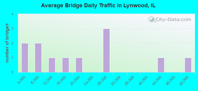
- 221,550Total average daily traffic
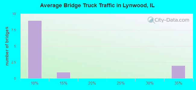
- 33,152Total average daily truck traffic
- National Bridge Inventory (NBI) Registered Bridges for Lynwood
- No street view available for this location
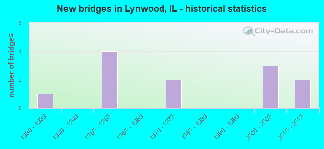
- New bridges - historical statistics
- 11930-1939
- 41950-1959
- 21970-1979
- 32000-2009
- 22010-2019
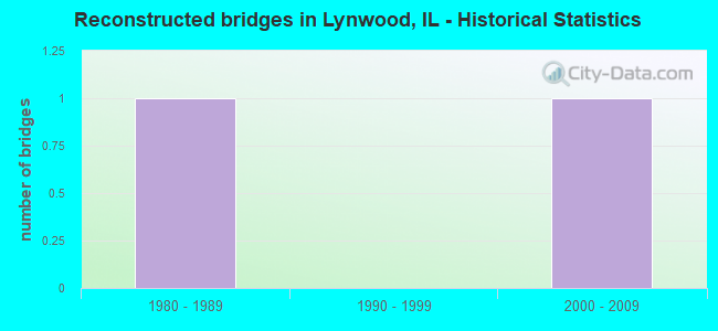
- Reconstructed bridges - Historical Statistics
- 11980-1989
- 01990-1999
- 12000-2009
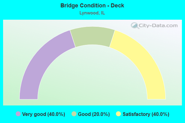
- Bridge Condition - Deck
- 40.0%Very good
- 20.0%Good
- 40.0%Satisfactory
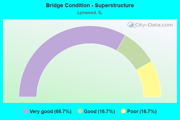
- Bridge Condition - Superstructure
- 66.7%Very good
- 16.7%Good
- 16.7%Poor
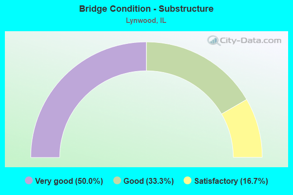
- Bridge Condition - Substructure
- 50.0%Very good
- 33.3%Good
- 16.7%Satisfactory
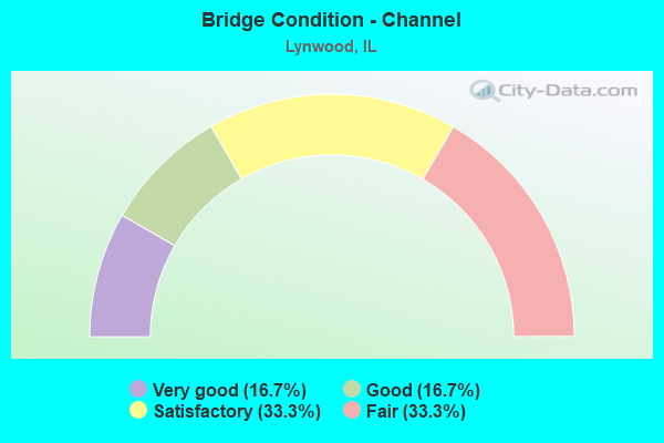
- Bridge Condition - Channel
- 16.7%Very good
- 16.7%Good
- 33.3%Satisfactory
- 33.3%Fair
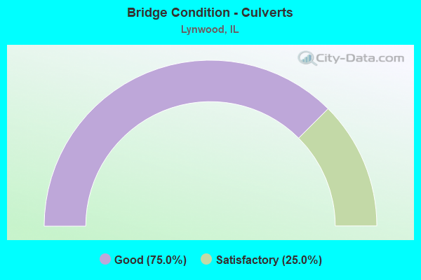
- Bridge Condition - Culverts
- 75.0%Good
- 25.0%Satisfactory
Find on map >> Show street view
Structure Number: 160624, Location: 3.1 M S I-80 (Lat: 41.533306, Lng: -87.582500), Route carried "on" structure: Other road , Year Built: 1954, Year Reconstructed: 1992, Status: Open, Structure Length: 7.14m (23.43ft), Average Daily Traffic: 10,650 (year 2021), Truck Traffic: 8%, Average Future Daily Traffic: 12,154 (year 2032), Design Load: HS 20, Features Intersected: IL 394, Facility Carried by Structure: GLENWOOD DYER RD
Minimum Vertical Clearance: 30+ m (98+ ft), Kilometerpoint: 6.550, Lanes on structure: 2, Lanes under structure: 4, Base Highway Network: Yes, Owner: State Highway Agency, Approaching Roadway Width: 12.8m (42.0ft), Skew: 22 degrees, Material/Design: Steel continuous, Design/Construction: Stringer/Multi-beam, Number Of Spans In Main Unit: 4, Length of Maximum Span: 19.5m (64.0ft), Curb or Sidewalk Widths: Left: 1.5m (4.9ft), Right: 1.5m (4.9ft), Curb-To-Curb Width: 12.8m (42.0ft), Out-to-Out Width: 16.5m (54.1ft)
Condition: Deck: Satisfactory, Superstructure: Poor, Substructure: Satisfactory, Operating Rating: 66.4 metric tons, Method Used To Determine Operating Rating: Load Factor (LF) rating reported by rating factor (RF) method using MS18 loading, Inventory Rating: 38.9 metric tons, Method Used To Determine Inventory Rating: Load Factor (LF) rating reported by rating factor (RF) method using MS18 loading, Structural Evaluation: Meets minimum limits, Deck Geometry: Somewhat better than minimum adequacy, Underclear: High priority of corrective action, Approach Roadway Alignment: Equal to present desirable criteria, Length Of Structure Improvement: 7.10m (23.29ft), Designated Inspection Frequency: Every 12 months, Inspection Date: August 2021, Bridge Improvement Cost: $193,000, Roadway Improvement Cost: $10,000, Total Project Cost: $232,000, Deck Structure Type: Concrete Cast-file-Place, Wearing Surface/Protective System: Deck Protection: Epoxy Coated Reinforcing
Find on map >> Show street view
Structure Number: 161203, Location: 1.0 Miles N of IL 83 (Lat: 41.527225, Lng: -87.539033), Route carried "on" structure: Other road , Year Built: 1935, Status: Posted for load, Structure Length: 0.67m (2.20ft), Average Daily Traffic: 5,800 (year 2018), Truck Traffic: 5%, Average Future Daily Traffic: 7,828 (year 2032), Features Intersected: NORTH CREEK, Facility Carried by Structure: BURNHAM AVE
Minimum Vertical Clearance: 30+ m (98+ ft), Kilometerpoint: 19.537, Lanes on structure: 2, Base Highway Network: Yes, Owner: State Highway Agency, Approaching Roadway Width: 7.3m (24.0ft), Material/Design: Concrete continuous, Design/Construction: Culvert, Number Of Spans In Main Unit: 2, Length of Maximum Span: 3.3m (10.8ft)
Condition: Channel: Satisfactory, Culverts: Good, Operating Rating: 34.7 metric tons, Method Used To Determine Operating Rating: Load Factor (LF) rating reported by rating factor (RF) method using MS18 loading, Inventory Rating: 20.7 metric tons, Method Used To Determine Inventory Rating: Load Factor (LF) rating reported by rating factor (RF) method using MS18 loading, Structural Evaluation: Somewhat better than minimum adequacy, Waterway Adequacy: Better than present minimum criteria, Approach Roadway Alignment: Equal to present desirable criteria, Bridge Posting: Required (Relationship of Operating Rating to Maximum Legal Load: 30.0 - 39.9% below), Designated Inspection Frequency: Every 12 months, Inspection Date: July 2021
Find on map >> Show street view
Structure Number: 16135, Location: 0.16 M N of Sauk Tr (Lat: 41.497872, Lng: -87.528847), Route carried "on" structure: US 30, Year Built: 2015, Status: Open, Structure Length: 4.00m (13.12ft), Average Daily Traffic: 25,400 (year 2021), Truck Traffic: 7%, Average Future Daily Traffic: 52,100 (year 2040), Design Load: HS 25 or greater, Features Intersected: RR - CN / EJ&E
Minimum Vertical Clearance: 30+ m (98+ ft), Kilometerpoint: 245.354, Lanes on structure: 4, Base Highway Network: Yes, Owner: State Highway Agency, Approaching Roadway Width: 17.7m (58.1ft), Skew: 30 degrees, Material/Design: Steel continuous, Design/Construction: Stringer/Multi-beam, Number Of Spans In Main Unit: 2, Length of Maximum Span: 22.0m (72.2ft), Curb or Sidewalk Widths: Left: 4.3m (14.1ft), Right: 0.0m, Curb-To-Curb Width: 17.7m (58.1ft), Out-to-Out Width: 24.3m (79.7ft)
Condition: Deck: Very good, Superstructure: Very good, Substructure: Very good, Operating Rating: 93.0 metric tons, Method Used To Determine Operating Rating: Load and Resistance Factor Rating (LRFR) rating reported by rating factor(RF) method using HL-93 loadings, Inventory Rating: 71.6 metric tons, Method Used To Determine Inventory Rating: Load and Resistance Factor Rating (LRFR) rating reported by rating factor(RF) method using HL-93 loadings, Structural Evaluation: Equal to present desirable criteria, Deck Geometry: Somewhat better than minimum adequacy, Underclear: Equal to present desirable criteria, Approach Roadway Alignment: Equal to present desirable criteria, Designated Inspection Frequency: Every 48 months, Inspection Date: September 2021, Deck Structure Type: Concrete Cast-file-Place, Wearing Surface/Protective System: Deck Protection: Epoxy Coated Reinforcing
Find on map >> Show street view
Structure Number: 161415, Location: US30 1200' N of Sauk (Lat: 41.499106, Lng: -87.528911), Route carried "on" structure: US 30, Year Built: 2015, Status: Open, Structure Length: 1.18m (3.87ft), Average Daily Traffic: 25,400 (year 2021), Truck Traffic: 7%, Average Future Daily Traffic: 52,100 (year 2040), Design Load: HS 25 or greater, Features Intersected: BIKE PATH & PIPELINE
Minimum Vertical Clearance: 30+ m (98+ ft), Kilometerpoint: 245.209, Lanes on structure: 4, Base Highway Network: Yes, Owner: State Highway Agency, Approaching Roadway Width: 16.5m (54.1ft), Skew: 30 degrees, Material/Design: Concrete, Design/Construction: Frame, Number Of Spans In Main Unit: 1, Length of Maximum Span: 11.4m (37.4ft), Curb or Sidewalk Widths: Left: 4.3m (14.1ft), Right: 0.0m
Condition: Superstructure: Good, Substructure: Very good, Operating Rating: 42.1 metric tons, Method Used To Determine Operating Rating: Assigned ratings based on Load and Resistance Factor Design (LRFD) reported by rating factor (RF) using HL93 loadings, Inventory Rating: 32.4 metric tons, Method Used To Determine Inventory Rating: Assigned ratings based on Load and Resistance Factor Design (LRFD) reported by rating factor (RF) using HL93 loadings, Structural Evaluation: Better than present minimum criteria, Approach Roadway Alignment: Equal to present desirable criteria, Designated Inspection Frequency: Every 48 months, Inspection Date: November 2021
Find on map >> Show street view
Structure Number: 162121, Location: 4.0 M S I-80 (Lat: 41.520800, Lng: -87.580522), Route carried "on" structure: Other road , Year Built: 1954, Year Reconstructed: 2012, Status: Open, Structure Length: 6.86m (22.51ft), Average Daily Traffic: 5,600 (year 2018), Truck Traffic: 33%, Average Future Daily Traffic: 7,416 (year 2032), Design Load: HS 20, Features Intersected: IL 394, Facility Carried by Structure: JOE ORR RD
Minimum Vertical Clearance: 30+ m (98+ ft), Kilometerpoint: 7.837, Lanes on structure: 2, Lanes under structure: 4, Base Highway Network: Yes, Owner: State Highway Agency, Approaching Roadway Width: 12.2m (40.0ft), Skew: 2 degrees, Material/Design: Steel continuous, Design/Construction: Stringer/Multi-beam, Number Of Spans In Main Unit: 4, Length of Maximum Span: 18.7m (61.4ft), Curb or Sidewalk Widths: Left: 1.8m (5.9ft), Right: 1.8m (5.9ft), Curb-To-Curb Width: 8.5m (27.9ft), Out-to-Out Width: 12.2m (40.0ft)
Condition: Deck: Very good, Superstructure: Very good, Substructure: Good, Operating Rating: 89.1 metric tons, Method Used To Determine Operating Rating: Load Factor (LF) rating reported by rating factor (RF) method using MS18 loading, Inventory Rating: 68.4 metric tons, Method Used To Determine Inventory Rating: Load Factor (LF) rating reported by rating factor (RF) method using MS18 loading, Structural Evaluation: Better than present minimum criteria, Deck Geometry: Meets minimum limits, Underclear: High priority of corrective action, Approach Roadway Alignment: Equal to present minimum criteria, Length Of Structure Improvement: 6.28m (20.60ft), Designated Inspection Frequency: Every 48 months, Inspection Date: July 2018, Bridge Improvement Cost: $547,000, Roadway Improvement Cost: $55,000, Total Project Cost: $821,000, Deck Structure Type: Concrete Cast-file-Place, Wearing Surface/Protective System: Deck Protection: Epoxy Coated Reinforcing
Find on map >> Show street view
Structure Number: 162727, Location: 2.3 M S I-80,94 (Lat: 41.545617, Lng: -87.558614), Route carried "on" structure: State highway 83, Year Built: 2003, Status: Open, Structure Length: 2.40m (7.87ft), Average Daily Traffic: 12,700 (year 2021), Truck Traffic: 6%, Average Future Daily Traffic: 15,759 (year 2032), Design Load: HS 20, Features Intersected: NORTH CREEK
Minimum Vertical Clearance: 30+ m (98+ ft), Kilometerpoint: 5.327, Lanes on structure: 2, Base Highway Network: Yes, Owner: State Highway Agency, Approaching Roadway Width: 12.0m (39.4ft), Material/Design: Steel, Design/Construction: Stringer/Multi-beam, Number Of Spans In Main Unit: 1, Length of Maximum Span: 23.3m (76.4ft), Curb-To-Curb Width: 12.0m (39.4ft), Out-to-Out Width: 13.0m (42.7ft)
Condition: Deck: Good, Superstructure: Very good, Substructure: Very good, Channel: Satisfactory, Operating Rating: 89.1 metric tons, Method Used To Determine Operating Rating: Load Factor (LF) rating reported by rating factor (RF) method using MS18 loading, Inventory Rating: 60.3 metric tons, Method Used To Determine Inventory Rating: Load Factor (LF) rating reported by rating factor (RF) method using MS18 loading, Structural Evaluation: Equal to present desirable criteria, Deck Geometry: Somewhat better than minimum adequacy, Waterway Adequacy: Superior to present desirable criteria, Approach Roadway Alignment: Equal to present desirable criteria, Designated Inspection Frequency: Every 48 months, Inspection Date: July 2018, Deck Structure Type: Concrete Cast-file-Place, Wearing Surface/Protective System: Deck Protection: Epoxy Coated Reinforcing
Find on map >> Show street view
Structure Number: 162784, Location: 0.2 M SE US 30/IL83 (Lat: 41.504039, Lng: -87.531775), Route carried "on" structure: US 30, Year Built: 2003, Status: Open, Structure Length: 2.07m (6.79ft), Average Daily Traffic: 25,400 (year 2021), Truck Traffic: 7%, Average Future Daily Traffic: 21,527 (year 2032), Features Intersected: LANSING DRNAGE DITCH
Minimum Vertical Clearance: 30+ m (98+ ft), Kilometerpoint: 244.630, Lanes on structure: 4, Base Highway Network: Yes, Owner: State Highway Agency, Approaching Roadway Width: 20.1m (65.9ft), Skew: 3 degrees, Material/Design: Prestressed concrete, Design/Construction: Stringer/Multi-beam, Number Of Spans In Main Unit: 1, Length of Maximum Span: 19.8m (65.0ft), Curb-To-Curb Width: 20.1m (65.9ft), Out-to-Out Width: 21.1m (69.2ft)
Condition: Deck: Satisfactory, Superstructure: Very good, Substructure: Good, Channel: Fair, Operating Rating: 72.6 metric tons, Method Used To Determine Operating Rating: Load Factor (LF) rating reported by rating factor (RF) method using MS18 loading, Inventory Rating: 45.0 metric tons, Method Used To Determine Inventory Rating: Load Factor (LF) rating reported by rating factor (RF) method using MS18 loading, Structural Evaluation: Better than present minimum criteria, Deck Geometry: Better than present minimum criteria, Waterway Adequacy: Superior to present desirable criteria, Approach Roadway Alignment: Superior to present desirable criteria, Designated Inspection Frequency: Every 48 months, Inspection Date: July 2020, Deck Structure Type: Concrete Cast-file-Place, Wearing Surface/Protective System: Deck Protection: Epoxy Coated Reinforcing
Find on map >> Show street view
Structure Number: 162827, Location: 0.6 M E OF TORRENCE (Lat: 41.506497, Lng: -87.547314), Route carried "on" structure: US 30, Year Built: 2003, Status: Open, Structure Length: 0.70m (2.30ft), Average Daily Traffic: 16,400 (year 2021), Truck Traffic: 8%, Average Future Daily Traffic: 18,000 (year 2032), Features Intersected: DRAINAGE DITCH
Minimum Vertical Clearance: 30+ m (98+ ft), Kilometerpoint: 243.181, Lanes on structure: 5, Base Highway Network: Yes, Owner: State Highway Agency, Approaching Roadway Width: 19.5m (64.0ft), Material/Design: Concrete continuous, Design/Construction: Culvert, Number Of Spans In Main Unit: 3, Length of Maximum Span: 2.1m (6.9ft)
Condition: Channel: Very good, Culverts: Good, Operating Rating: 69.7 metric tons, Method Used To Determine Operating Rating: Load Factor (LF) rating reported by rating factor (RF) method using MS18 loading, Inventory Rating: 41.8 metric tons, Method Used To Determine Inventory Rating: Load Factor (LF) rating reported by rating factor (RF) method using MS18 loading, Structural Evaluation: Better than present minimum criteria, Waterway Adequacy: Equal to present desirable criteria, Approach Roadway Alignment: Equal to present desirable criteria, Designated Inspection Frequency: Every 48 months, Inspection Date: July 2018, Deck Structure Type: Other
Find on map >> Show street view
Structure Number: 167387, Location: 0.01 M E ILL 83 P2 (Lat: 41.535847, Lng: -87.558244), Route carried "on" structure: City street , Year Built: 1973, Status: Open, Structure Length: 0.76m (2.49ft), Average Daily Traffic: 500 (year 2018), Truck Traffic: 8%, Average Future Daily Traffic: 524 (year 2032), Features Intersected: LANSING DRN DTCH, Facility Carried by Structure: 198 ST
Minimum Vertical Clearance: 30+ m (98+ ft), Kilometerpoint: 0.032, Lanes on structure: 2, Owner: City or Municipal Highway Agency, Approaching Roadway Width: 11.6m (38.1ft), Material/Design: Concrete continuous, Design/Construction: Culvert, Number Of Spans In Main Unit: 3, Length of Maximum Span: 2.2m (7.2ft), Curb-To-Curb Width: 10.7m (35.1ft), Out-to-Out Width: 18.3m (60.0ft)
Condition: Channel: Good, Culverts: Good, Operating Rating: 40.5 metric tons, Method Used To Determine Operating Rating: Field evaluation and documented engineering judgment, Inventory Rating: 24.3 metric tons, Method Used To Determine Inventory Rating: Field evaluation and documented engineering judgment, Structural Evaluation: Equal to present minimum criteria, Deck Geometry: Equal to present minimum criteria, Waterway Adequacy: Better than present minimum criteria, Approach Roadway Alignment: Equal to present minimum criteria, Designated Inspection Frequency: Every 24 months, Inspection Date: July 2020, Deck Structure Type: Other, Wearing Surface/Protective System: Wearing Surface: Bituminous
Find on map >> Show street view
Structure Number: 167389, Location: 0.01 M E ILL 83 P2 (Lat: 41.530453, Lng: -87.558153), Route carried "on" structure: Other road , Year Built: 1974, Status: Open, Structure Length: 0.76m (2.49ft), Average Daily Traffic: 3,300 (year 2018), Truck Traffic: 6%, Average Future Daily Traffic: 3,760 (year 2032), Features Intersected: LANSING DITCH LYN TR, Facility Carried by Structure: 201 ST
Minimum Vertical Clearance: 30+ m (98+ ft), Kilometerpoint: 0.032, Lanes on structure: 4, Owner: City or Municipal Highway Agency, Approaching Roadway Width: 15.2m (49.9ft), Skew: 30 degrees, Material/Design: Concrete continuous, Design/Construction: Culvert, Number Of Spans In Main Unit: 3, Length of Maximum Span: 2.2m (7.2ft), Curb-To-Curb Width: 14.3m (46.9ft), Out-to-Out Width: 21.3m (69.9ft)
Condition: Channel: Fair, Culverts: Satisfactory, Operating Rating: 40.5 metric tons, Method Used To Determine Operating Rating: Field evaluation and documented engineering judgment, Inventory Rating: 24.3 metric tons, Method Used To Determine Inventory Rating: Field evaluation and documented engineering judgment, Structural Evaluation: Equal to present minimum criteria, Deck Geometry: High priority of replacement, Waterway Adequacy: Equal to present desirable criteria, Approach Roadway Alignment: Equal to present desirable criteria, Designated Inspection Frequency: Every 24 months, Inspection Date: September 2021, Deck Structure Type: Other, Wearing Surface/Protective System: Wearing Surface: Bituminous
Find on map >> Show street view
Structure Number: 160624, Location: 3.1 M S I-80 (Lat: 41.533306, Lng: -87.582500), Route carried "under" structure: State highway 394, Year Built: 1954, Structure Length: 0. m, Average Daily Traffic: 49,300 (year 2017), Truck Traffic: 34%, Features Intersected: IL 394, Facility Carried by Structure: GLENWOOD DYER RD
Minimum Vertical Clearance: 4.55m (14.93ft), Kilometerpoint: 18.040, Lanes on structure: 2, Lanes under structure: 4, Material/Design: Steel continuous, Design/Construction: Stringer/Multi-beam, Length of Maximum Span: 19.5m (64.0ft)
Find on map >> Show street view
Structure Number: 162121, Location: 4.0 M S I-80 (Lat: 41.520800, Lng: -87.580086), Route carried "under" structure: State highway 394, Year Built: 1954, Structure Length: 0. m, Average Daily Traffic: 41,100 (year 2017), Truck Traffic: 14%, Features Intersected: IL 394, Facility Carried by Structure: JOE ORR RD
Minimum Vertical Clearance: 4.88m (16.01ft), Kilometerpoint: 16.624, Lanes on structure: 2, Lanes under structure: 4, Material/Design: Steel continuous, Design/Construction: Stringer/Multi-beam, Length of Maximum Span: 18.7m (61.4ft)