Bridge Statistics for Madison, Alabama (AL)
Condition, Traffic, Stress, Structural Evaluation, Project Costs
- National Bridge Inventory (NBI) Statistics
- 32Number of bridges
- 200ft / 60.8mTotal length
- $35,644,000Total costs
- 100,175Total average daily traffic
- 11,636Total average daily truck traffic
- National Bridge Inventory (NBI) Registered Bridges for Madison
- No street view available for this location
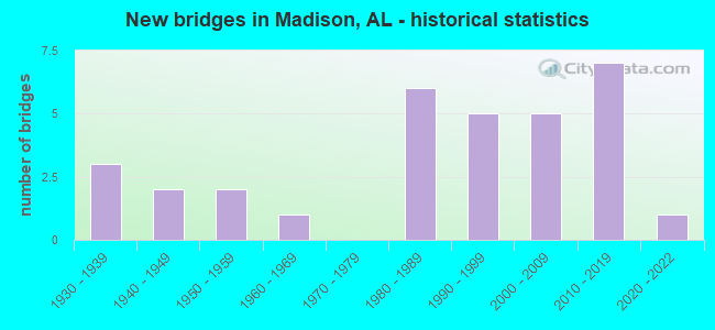
- New bridges - historical statistics
- 31930-1939
- 21940-1949
- 21950-1959
- 11960-1969
- 61980-1989
- 51990-1999
- 52000-2009
- 72010-2019
- 12020-2022

- Bridge Condition - Deck
- 22.2%Very good
- 44.4%Good
- 33.3%Satisfactory
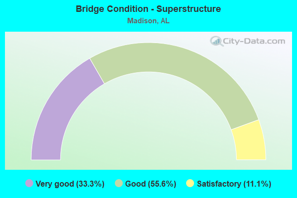
- Bridge Condition - Superstructure
- 33.3%Very good
- 55.6%Good
- 11.1%Satisfactory
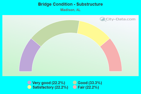
- Bridge Condition - Substructure
- 22.2%Very good
- 33.3%Good
- 22.2%Satisfactory
- 22.2%Fair
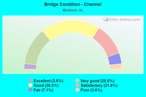
- Bridge Condition - Channel
- 3.6%Excellent
- 25.0%Very good
- 39.3%Good
- 21.4%Satisfactory
- 7.1%Fair
- 3.6%Poor
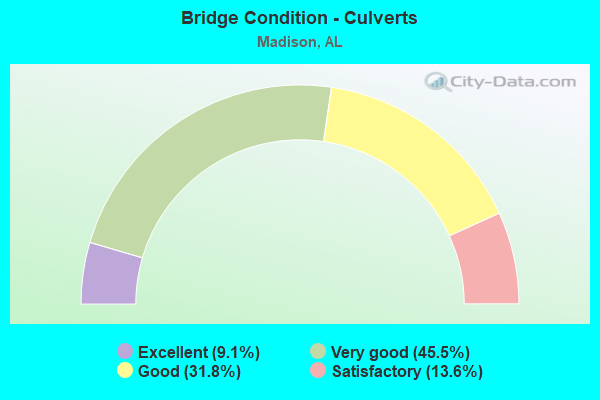
- Bridge Condition - Culverts
- 9.1%Excellent
- 45.5%Very good
- 31.8%Good
- 13.6%Satisfactory
Find on map >> Show street view
Structure Number: 1354, Location: 0.7 MI W SULLIVAN ST. (Lat: 34.700000, Lng: -86.763333), Route carried "on" structure: City street 1352, Year Built: 1935, Status: Open, Structure Length: 1.43m (4.69ft), Average Daily Traffic: 2,500 (year 1992), Truck Traffic: 10%, Average Future Daily Traffic: 3,200 (year 2035), Design Load: H 15, Features Intersected: MADISON BRANCH, Facility Carried by Structure: MILL ROAD
Minimum Vertical Clearance: 30+ m (98+ ft), Kilometerpoint: 0.000, Lanes on structure: 2, Owner: City or Municipal Highway Agency, Approaching Roadway Width: 7.3m (24.0ft), Skew: 4 degrees, Material/Design: Masonry, Design/Construction: Culvert, Number Of Spans In Main Unit: 3, Length of Maximum Span: 3.0m (9.8ft), Curb-To-Curb Width: 6.2m (20.3ft), Out-to-Out Width: 6.7m (22.0ft)
Condition: Channel: Fair, Culverts: Satisfactory, Operating Rating: 32.7 metric tons, Method Used To Determine Operating Rating: Field evaluation and documented engineering judgment, Inventory Rating: 23.6 metric tons, Method Used To Determine Inventory Rating: Field evaluation and documented engineering judgment, Structural Evaluation: Equal to present minimum criteria, Deck Geometry: High priority of replacement, Waterway Adequacy: Somewhat better than minimum adequacy, Approach Roadway Alignment: Equal to present minimum criteria, Length Of Structure Improvement: 2.11m (6.92ft), Designated Inspection Frequency: Every 24 months, Inspection Date: November 2020, Bridge Improvement Cost: $377,000, Roadway Improvement Cost: $38,000, Total Project Cost: $415,000 ( Estimate for 2022)
Find on map >> Show street view
Structure Number: 1712, Location: 0.2 MI N MILL RD (Lat: 34.701667, Lng: -86.750000), Route carried "on" structure: City street 1005, Year Built: 1938, Status: Posted for load, Structure Length: 0.73m (2.40ft), Average Daily Traffic: 12,000 (year 1992), Truck Traffic: 20%, Average Future Daily Traffic: 16,530 (year 2035), Design Load: H 15, Features Intersected: MADISON BRANCH, Facility Carried by Structure: WALL-TRIANA HWY
Minimum Vertical Clearance: 30+ m (98+ ft), Kilometerpoint: 0.000, Lanes on structure: 2, Owner: City or Municipal Highway Agency, Approaching Roadway Width: 7.9m (25.9ft), Skew: 2 degrees, Material/Design: Steel, Design/Construction: Stringer/Multi-beam, Number Of Spans In Main Unit: 1, Length of Maximum Span: 7.3m (24.0ft), Curb-To-Curb Width: 9.8m (32.2ft), Out-to-Out Width: 10.4m (34.1ft)
Condition: Deck: Good, Superstructure: Satisfactory, Substructure: Satisfactory, Channel: Satisfactory, Operating Rating: 32.7 metric tons, Method Used To Determine Operating Rating: Allowable Stress (AS), Inventory Rating: 16.2 metric tons, Method Used To Determine Inventory Rating: Allowable Stress (AS), Structural Evaluation: Meets minimum limits, Deck Geometry: Meets minimum limits, Waterway Adequacy: Somewhat better than minimum adequacy, Approach Roadway Alignment: Somewhat better than minimum adequacy, Bridge Posting: Required (Relationship of Operating Rating to Maximum Legal Load: 30.0 - 39.9% below), Length Of Structure Improvement: 1.38m (4.53ft), Designated Inspection Frequency: Every 24 months, Other Special Inspection Frequency: Every 12 months, Inspection Date: November 2020, Other Special Inspection Date: November 2021, Bridge Improvement Cost: $321,000, Roadway Improvement Cost: $32,000, Total Project Cost: $353,000 ( Estimate for 2022), Deck Structure Type: Concrete Cast-file-Place, Wearing Surface/Protective System: Wearing Surface: Epoxy Overlay
Find on map >> Show street view
Structure Number: 1783, Location: 1.1 MI E LIMESTONE CO LI. (Lat: 34.706667, Lng: -86.768333), Route carried "on" structure: City street 1048, Year Built: 1938, Status: Open, Structure Length: 1.04m (3.41ft), Average Daily Traffic: 850 (year 1992), Truck Traffic: 8%, Average Future Daily Traffic: 1,140 (year 2035), Design Load: H 15, Features Intersected: MILL CREEK, Facility Carried by Structure: BROWNS FERRY RD
Minimum Vertical Clearance: 30+ m (98+ ft), Kilometerpoint: 0.000, Lanes on structure: 2, Owner: City or Municipal Highway Agency, Approaching Roadway Width: 7.9m (25.9ft), Material/Design: Concrete, Design/Construction: Tee Beam, Number Of Spans In Main Unit: 1, Length of Maximum Span: 10.4m (34.1ft), Curb-To-Curb Width: 7.2m (23.6ft), Out-to-Out Width: 8.0m (26.2ft)
Condition: Deck: Good, Superstructure: Good, Substructure: Fair, Channel: Fair, Operating Rating: 32.7 metric tons, Method Used To Determine Operating Rating: Field evaluation and documented engineering judgment, Inventory Rating: 23.6 metric tons, Method Used To Determine Inventory Rating: Field evaluation and documented engineering judgment, Structural Evaluation: Somewhat better than minimum adequacy, Deck Geometry: Meets minimum limits, Waterway Adequacy: Somewhat better than minimum adequacy, Approach Roadway Alignment: Somewhat better than minimum adequacy, Length Of Structure Improvement: 1.71m (5.61ft), Designated Inspection Frequency: Every 24 months, Inspection Date: November 2020, Bridge Improvement Cost: $305,000, Roadway Improvement Cost: $31,000, Total Project Cost: $336,000 ( Estimate for 2022), Deck Structure Type: Concrete Cast-file-Place, Wearing Surface/Protective System: Wearing Surface: Bituminous
Find on map >> Show street view
Structure Number: 2495, Location: 1 MI W SULLIVAN STREET (Lat: 34.688333, Lng: -86.771667), Route carried "on" structure: City street 1382, Year Built: 1940, Status: Posted for load, Structure Length: 1.83m (6.00ft), Average Daily Traffic: 950 (year 1992), Truck Traffic: 20%, Average Future Daily Traffic: 1,368 (year 2035), Design Load: H 15, Features Intersected: BRADFORD CREEK, Facility Carried by Structure: PALMER ROAD
Minimum Vertical Clearance: 30+ m (98+ ft), Kilometerpoint: 0.000, Lanes on structure: 2, Owner: City or Municipal Highway Agency, Approaching Roadway Width: 7.9m (25.9ft), Material/Design: Concrete, Design/Construction: Tee Beam, Number Of Spans In Main Unit: 2, Length of Maximum Span: 9.1m (29.9ft), Curb-To-Curb Width: 7.3m (24.0ft), Out-to-Out Width: 8.0m (26.2ft)
Condition: Deck: Satisfactory, Superstructure: Good, Substructure: Satisfactory, Channel: Satisfactory, Operating Rating: 36.5 metric tons, Method Used To Determine Operating Rating: Load Factor (LF), Inventory Rating: 21.9 metric tons, Method Used To Determine Inventory Rating: Load Factor (LF), Structural Evaluation: Somewhat better than minimum adequacy, Deck Geometry: Meets minimum limits, Waterway Adequacy: Somewhat better than minimum adequacy, Approach Roadway Alignment: Somewhat better than minimum adequacy, Bridge Posting: Required (Relationship of Operating Rating to Maximum Legal Load: > 39.9% below), Length Of Structure Improvement: 2.54m (8.33ft), Designated Inspection Frequency: Every 24 months, Other Special Inspection Frequency: Every 12 months, Inspection Date: November 2020, Other Special Inspection Date: November 2021, Bridge Improvement Cost: $454,000, Roadway Improvement Cost: $45,000, Total Project Cost: $499,000 ( Estimate for 2022), Deck Structure Type: Concrete Cast-file-Place, Wearing Surface/Protective System: Wearing Surface: Bituminous
Find on map >> Show street view
Structure Number: 2496, Location: 0.8 MI W SULLIVAN ST. (Lat: 34.691667, Lng: -86.766667), Route carried "on" structure: City street 1382, Year Built: 1940, Status: Posted for load, Structure Length: 1.83m (6.00ft), Average Daily Traffic: 950 (year 1992), Truck Traffic: 20%, Average Future Daily Traffic: 1,368 (year 2035), Design Load: H 15, Features Intersected: PALMER BRANCH, Facility Carried by Structure: PALMER ROAD
Minimum Vertical Clearance: 30+ m (98+ ft), Kilometerpoint: 0.000, Lanes on structure: 2, Owner: City or Municipal Highway Agency, Approaching Roadway Width: 7.9m (25.9ft), Material/Design: Concrete, Design/Construction: Tee Beam, Number Of Spans In Main Unit: 2, Length of Maximum Span: 9.1m (29.9ft), Curb-To-Curb Width: 7.3m (24.0ft), Out-to-Out Width: 8.0m (26.2ft)
Condition: Deck: Satisfactory, Superstructure: Good, Substructure: Fair, Channel: Poor, Operating Rating: 35.2 metric tons, Method Used To Determine Operating Rating: Load Factor (LF), Inventory Rating: 21.1 metric tons, Method Used To Determine Inventory Rating: Load Factor (LF), Structural Evaluation: Somewhat better than minimum adequacy, Deck Geometry: Meets minimum limits, Waterway Adequacy: Equal to present minimum criteria, Approach Roadway Alignment: Equal to present minimum criteria, Bridge Posting: Required (Relationship of Operating Rating to Maximum Legal Load: > 39.9% below), Length Of Structure Improvement: 2.54m (8.33ft), Designated Inspection Frequency: Every 24 months, Other Special Inspection Frequency: Every 12 months, Inspection Date: November 2020, Other Special Inspection Date: November 2021, Bridge Improvement Cost: $454,000, Roadway Improvement Cost: $45,000, Total Project Cost: $499,000 ( Estimate for 2022), Deck Structure Type: Concrete Cast-file-Place, Wearing Surface/Protective System: Wearing Surface: Bituminous
Find on map >> Show street view
Structure Number: 4953, Location: SEC11 T4S R3W (Lat: 34.713375, Lng: -86.815650), Route carried "on" structure: County highway 119, Year Built: 1954, Status: Open, Structure Length: 0.64m (2.10ft), Average Daily Traffic: 2,487 (year 2017), Truck Traffic: 4%, Average Future Daily Traffic: 3,865 (year 2039), Design Load: H 15, Features Intersected: MOORE BR, Facility Carried by Structure: SEGERS RD
Minimum Vertical Clearance: 30+ m (98+ ft), Kilometerpoint: 0.010, Lanes on structure: 2, Owner: County Highway Agency, Approaching Roadway Width: 6.7m (22.0ft), Material/Design: Steel, Design/Construction: Culvert, Number Of Spans In Main Unit: 3, Length of Maximum Span: 2.1m (6.9ft), Curb-To-Curb Width: 9.9m (32.5ft), Out-to-Out Width: 9.9m (32.5ft)
Condition: Channel: Good, Culverts: Good, Operating Rating: 88.9 metric tons, Method Used To Determine Operating Rating: Load Factor (LF), Inventory Rating: 88.9 metric tons, Method Used To Determine Inventory Rating: Load Factor (LF), Structural Evaluation: Better than present minimum criteria, Deck Geometry: Meets minimum limits, Waterway Adequacy: Better than present minimum criteria, Approach Roadway Alignment: Equal to present desirable criteria, Length Of Structure Improvement: 1.26m (4.13ft), Designated Inspection Frequency: Every 24 months, Inspection Date: March 2020, Bridge Improvement Cost: $218,000, Roadway Improvement Cost: $22,000, Total Project Cost: $240,000 ( Estimate for 2022)
Find on map >> Show street view
Structure Number: 5187, Location: SEC2 T4S R3W (Lat: 34.714617, Lng: -86.820131), Route carried "on" structure: County highway 18, Year Built: 1955, Status: Open, Structure Length: 0.98m (3.22ft), Average Daily Traffic: 1,968 (year 2017), Truck Traffic: 4%, Average Future Daily Traffic: 3,042 (year 2039), Design Load: H 15, Features Intersected: OAKLAND SPRING BR, Facility Carried by Structure: POWELL ROAD
Minimum Vertical Clearance: 30+ m (98+ ft), Kilometerpoint: 0.010, Lanes on structure: 2, Owner: County Highway Agency, Approaching Roadway Width: 8.5m (27.9ft), Material/Design: Concrete, Design/Construction: Culvert, Number Of Spans In Main Unit: 3, Length of Maximum Span: 3.0m (9.8ft), Curb-To-Curb Width: 9.2m (30.2ft), Out-to-Out Width: 9.8m (32.2ft)
Condition: Channel: Satisfactory, Culverts: Good, Operating Rating: 38.9 metric tons, Method Used To Determine Operating Rating: Load Factor (LF), Inventory Rating: 23.3 metric tons, Method Used To Determine Inventory Rating: Load Factor (LF), Structural Evaluation: Equal to present minimum criteria, Deck Geometry: Somewhat better than minimum adequacy, Waterway Adequacy: Equal to present minimum criteria, Approach Roadway Alignment: Better than present minimum criteria, Length Of Structure Improvement: 1.65m (5.41ft), Designated Inspection Frequency: Every 24 months, Inspection Date: August 2020, Bridge Improvement Cost: $306,000, Roadway Improvement Cost: $31,000, Total Project Cost: $337,000 ( Estimate for 2022)
Find on map >> Show street view
Structure Number: 8734, Location: 1.6 MI E MADISON CO. LINE (Lat: 34.671667, Lng: -86.763333), Route carried "on" structure: City street 20, Year Built: 1965, Status: Open, Structure Length: 8.29m (27.20ft), Average Daily Traffic: 2,920 (year 2000), Truck Traffic: 10%, Average Future Daily Traffic: 6,612 (year 2035), Design Load: HS 20, Features Intersected: BRADFORD CREEK, Facility Carried by Structure: MADISON BLVD.
Minimum Vertical Clearance: 30+ m (98+ ft), Kilometerpoint: 133.085, Lanes on structure: 2, Base Highway Network: Yes, Owner: City or Municipal Highway Agency, Approaching Roadway Width: 13.4m (44.0ft), Skew: 10 degrees, Material/Design: Concrete, Design/Construction: Tee Beam, Number Of Spans In Main Unit: 8, Length of Maximum Span: 10.4m (34.1ft), Curb or Sidewalk Widths: Left: 0.5m (1.6ft), Right: 0.5m (1.6ft), Curb-To-Curb Width: 8.5m (27.9ft), Out-to-Out Width: 10.1m (33.1ft)
Condition: Deck: Satisfactory, Superstructure: Good, Substructure: Good, Channel: Good, Operating Rating: 67.0 metric tons, Method Used To Determine Operating Rating: Allowable Stress (AS), Inventory Rating: 43.5 metric tons, Method Used To Determine Inventory Rating: Allowable Stress (AS), Structural Evaluation: Better than present minimum criteria, Deck Geometry: High priority of corrective action, Waterway Adequacy: Equal to present minimum criteria, Approach Roadway Alignment: Better than present minimum criteria, Length Of Structure Improvement: 9.29m (30.48ft), Designated Inspection Frequency: Every 24 months, Inspection Date: November 2020, Bridge Improvement Cost: $2,102,000, Roadway Improvement Cost: $210,000, Total Project Cost: $2,312,000 ( Estimate for 2022), Deck Structure Type: Concrete Cast-file-Place
Find on map >> Show street view
Structure Number: 13871, Location: 0.3 MI N HWY 20 (Lat: 34.683333, Lng: -86.763333), Route carried "on" structure: Business City street 1, Year Built: 1986, Status: Open, Structure Length: 1.01m (3.31ft), Average Daily Traffic: 600 (year 1992), Truck Traffic: 20%, Average Future Daily Traffic: 1,083 (year 2035), Design Load: HS 20, Features Intersected: BRADFORD BRANCH, Facility Carried by Structure: WESTCHESTER RD
Minimum Vertical Clearance: 30+ m (98+ ft), Kilometerpoint: 0.000, Lanes on structure: 3, Owner: City or Municipal Highway Agency, Approaching Roadway Width: 9.8m (32.2ft), Skew: 1 degrees, Material/Design: Concrete, Design/Construction: Culvert, Number Of Spans In Main Unit: 3, Length of Maximum Span: 3.0m (9.8ft), Curb-To-Curb Width: 17.7m (58.1ft), Out-to-Out Width: 18.3m (60.0ft)
Condition: Channel: Good, Culverts: Very good, Operating Rating: 87.1 metric tons, Method Used To Determine Operating Rating: Load Factor (LF), Inventory Rating: 52.2 metric tons, Method Used To Determine Inventory Rating: Load Factor (LF), Structural Evaluation: Equal to present desirable criteria, Deck Geometry: Superior to present desirable criteria, Waterway Adequacy: Better than present minimum criteria, Approach Roadway Alignment: Equal to present desirable criteria, Length Of Structure Improvement: 1.68m (5.51ft), Designated Inspection Frequency: Every 24 months, Inspection Date: November 2020, Bridge Improvement Cost: $320,000, Roadway Improvement Cost: $32,000, Total Project Cost: $352,000 ( Estimate for 2022)
Find on map >> Show street view
Structure Number: 13883, Location: 0.5 MI N OLD MADISON PIKE (Lat: 34.711667, Lng: -86.725000), Route carried "on" structure: City street 3, Year Built: 1986, Status: Open, Structure Length: 0.98m (3.22ft), Average Daily Traffic: 800 (year 1992), Truck Traffic: 2%, Average Future Daily Traffic: 1,368 (year 2035), Design Load: HS 20, Features Intersected: RAINBOW CREEK, Facility Carried by Structure: MILLER BLVD.
Minimum Vertical Clearance: 30+ m (98+ ft), Kilometerpoint: 0.000, Lanes on structure: 2, Owner: City or Municipal Highway Agency, Approaching Roadway Width: 8.5m (27.9ft), Material/Design: Concrete, Design/Construction: Channel Beam, Number Of Spans In Main Unit: 1, Length of Maximum Span: 9.8m (32.2ft), Curb-To-Curb Width: 9.1m (29.9ft), Out-to-Out Width: 9.4m (30.8ft)
Condition: Deck: Good, Superstructure: Very good, Substructure: Good, Channel: Satisfactory, Operating Rating: 43.5 metric tons, Method Used To Determine Operating Rating: Field evaluation and documented engineering judgment, Inventory Rating: 32.7 metric tons, Method Used To Determine Inventory Rating: Field evaluation and documented engineering judgment, Structural Evaluation: Better than present minimum criteria, Deck Geometry: Equal to present minimum criteria, Waterway Adequacy: Equal to present minimum criteria, Approach Roadway Alignment: Equal to present minimum criteria, Length Of Structure Improvement: 1.65m (5.41ft), Designated Inspection Frequency: Every 24 months, Inspection Date: December 2020, Bridge Improvement Cost: $340,000, Roadway Improvement Cost: $34,000, Total Project Cost: $374,000 ( Estimate for 2022), Deck Structure Type: Concrete Precast Panels, Wearing Surface/Protective System: Wearing Surface: Bituminous
Find on map >> Show street view
Structure Number: 14187, Location: 150 FT. N STEELE DR (Lat: 34.715000, Lng: -86.728333), Route carried "on" structure: City street 2, Year Built: 1987, Status: Open, Structure Length: 0.70m (2.30ft), Average Daily Traffic: 450 (year 1992), Truck Traffic: 1%, Average Future Daily Traffic: 616 (year 2035), Design Load: HS 20, Features Intersected: RAINBOW CREEK, Facility Carried by Structure: CHERRY ROAD
Minimum Vertical Clearance: 30+ m (98+ ft), Kilometerpoint: 0.000, Lanes on structure: 2, Owner: City or Municipal Highway Agency, Approaching Roadway Width: 9.8m (32.2ft), Skew: 2 degrees, Material/Design: Concrete, Design/Construction: Culvert, Number Of Spans In Main Unit: 2, Length of Maximum Span: 3.0m (9.8ft), Curb-To-Curb Width: 14.7m (48.2ft), Out-to-Out Width: 15.2m (49.9ft)
Condition: Channel: Good, Culverts: Very good, Operating Rating: 78.1 metric tons, Method Used To Determine Operating Rating: Load Factor (LF), Inventory Rating: 46.8 metric tons, Method Used To Determine Inventory Rating: Load Factor (LF), Structural Evaluation: Equal to present desirable criteria, Deck Geometry: Superior to present desirable criteria, Waterway Adequacy: Better than present minimum criteria, Approach Roadway Alignment: Equal to present desirable criteria, Length Of Structure Improvement: 1.34m (4.40ft), Designated Inspection Frequency: Every 24 months, Inspection Date: December 2020, Bridge Improvement Cost: $379,000, Roadway Improvement Cost: $38,000, Total Project Cost: $417,000 ( Estimate for 2022)
Find on map >> Show street view
Structure Number: 14449, Location: 0.1 MI S JCT SR20*AIRPORT (Lat: 34.668889, Lng: -86.766667), Route carried "on" structure: Ramp Interstate 565, Year Built: 1988, Status: Open, Structure Length: 0.79m (2.59ft), Average Daily Traffic: 4,138 (year 2019), Truck Traffic: 3%, Average Future Daily Traffic: 5,793 (year 2039), Design Load: HS 20, Features Intersected: BRANCH, Facility Carried by Structure: RAMPS TO AIRPT RD
Minimum Vertical Clearance: 30+ m (98+ ft), Kilometerpoint: 12.794, Lanes on structure: 2, Base Highway Network: Yes, Owner: State Highway Agency, Approaching Roadway Width: 7.3m (24.0ft), Skew: 1 degrees, Material/Design: Concrete, Design/Construction: Culvert, Number Of Spans In Main Unit: 3, Length of Maximum Span: 2.4m (7.9ft)
Condition: Channel: Good, Culverts: Satisfactory, Operating Rating: 51.6 metric tons, Method Used To Determine Operating Rating: Load Factor (LF), Inventory Rating: 30.8 metric tons, Method Used To Determine Inventory Rating: Load Factor (LF), Structural Evaluation: Equal to present minimum criteria, Waterway Adequacy: Better than present minimum criteria, Approach Roadway Alignment: Better than present minimum criteria, Length Of Structure Improvement: 1.44m (4.72ft), Designated Inspection Frequency: Every 24 months, Inspection Date: Febuary 2021, Bridge Improvement Cost: $2,351,000, Roadway Improvement Cost: $235,000, Total Project Cost: $2,586,000 ( Estimate for 2022), Wearing Surface/Protective System: Wearing Surface: Bituminous
Find on map >> Show street view
Structure Number: 14778, Location: .3 M W JCT I565*AIRPRT RD (Lat: 34.668333, Lng: -86.763333), Route carried "on" structure: Ramp Interstate 565, Year Built: 1989, Status: Open, Structure Length: 7.38m (24.21ft), Average Daily Traffic: 2,305 (year 2020), Truck Traffic: 10%, Average Future Daily Traffic: 3,227 (year 2040), Design Load: HS 20, Features Intersected: RAMP43 INTO AIRPORT RD, Facility Carried by Structure: RAMP 45 TO SR 20
Minimum Vertical Clearance: 30+ m (98+ ft), Kilometerpoint: 13.358, Lanes on structure: 1, Lanes under structure: 2, Base Highway Network: Yes, Owner: State Highway Agency, Approaching Roadway Width: 8.5m (27.9ft), Material/Design: Steel continuous, Design/Construction: Stringer/Multi-beam, Number Of Spans In Main Unit: 3, Length of Maximum Span: 30.5m (100.1ft), Curb-To-Curb Width: 7.6m (24.9ft), Out-to-Out Width: 8.5m (27.9ft)
Condition: Deck: Good, Superstructure: Good, Substructure: Good, Operating Rating: 79.7 metric tons, Method Used To Determine Operating Rating: Load Factor (LF), Inventory Rating: 47.7 metric tons, Method Used To Determine Inventory Rating: Load Factor (LF), Structural Evaluation: Better than present minimum criteria, Deck Geometry: Better than present minimum criteria, Underclear: Superior to present desirable criteria, Approach Roadway Alignment: Equal to present minimum criteria, Length Of Structure Improvement: 8.40m (27.56ft), Designated Inspection Frequency: Every 24 months, Inspection Date: September 2021, Bridge Improvement Cost: $1,556,000, Roadway Improvement Cost: $156,000, Total Project Cost: $1,712,000 ( Estimate for 2022), Deck Structure Type: Concrete Cast-file-Place
Find on map >> Show street view
Structure Number: 16058, Location: 0.1 MI SOUTH OF MILL RD (Lat: 34.696700, Lng: -86.738800), Route carried "on" structure: City street , Year Built: 1993, Status: Open, Structure Length: 3.87m (12.70ft), Average Daily Traffic: 5,500 (year 1994), Truck Traffic: 10%, Average Future Daily Traffic: 8,550 (year 2035), Design Load: HS 20, Features Intersected: NORFOLK SOUTHERN RR, Facility Carried by Structure: HUGHES RD.
Minimum Vertical Clearance: 30+ m (98+ ft), Kilometerpoint: 0.000, Lanes on structure: 4, Owner: City or Municipal Highway Agency, Approaching Roadway Width: 15.8m (51.8ft), Skew: 3 degrees, Material/Design: Prestressed concrete, Design/Construction: Stringer/Multi-beam, Number Of Spans In Main Unit: 1, Length of Maximum Span: 38.7m (127.0ft), Curb or Sidewalk Widths: Left: 1.8m (5.9ft), Right: 0.0m, Curb-To-Curb Width: 18.3m (60.0ft), Out-to-Out Width: 19.1m (62.7ft)
Condition: Deck: Very good, Superstructure: Very good, Substructure: Very good, Operating Rating: 88.9 metric tons, Method Used To Determine Operating Rating: Load Factor (LF), Inventory Rating: 21.9 metric tons, Method Used To Determine Inventory Rating: Load Factor (LF), Structural Evaluation: Somewhat better than minimum adequacy, Deck Geometry: Somewhat better than minimum adequacy, Underclear: Superior to present desirable criteria, Approach Roadway Alignment: Better than present minimum criteria, Length Of Structure Improvement: 4.81m (15.78ft), Designated Inspection Frequency: Every 24 months, Inspection Date: December 2020, Bridge Improvement Cost: $2,046,000, Roadway Improvement Cost: $205,000, Total Project Cost: $2,251,000 ( Estimate for 2022), Deck Structure Type: Concrete Cast-file-Place
Find on map >> Show street view
Structure Number: 16772, Location: SEC 24 T4S R3W (Lat: 34.682089, Lng: -86.786606), Route carried "on" structure: County highway 127, Year Built: 1997, Status: Open, Structure Length: 4.57m (14.99ft), Average Daily Traffic: 2,500 (year 1997), Truck Traffic: 10%, Average Future Daily Traffic: 4,000 (year 2035), Design Load: HS 20, Features Intersected: SOUTHERN RAILROAD, Facility Carried by Structure: COUNTY LINE ROAD
Minimum Vertical Clearance: 0.00m, Kilometerpoint: 0.000, Lanes on structure: 2, Owner: City or Municipal Highway Agency, Approaching Roadway Width: 20.7m (67.9ft), Skew: 2 degrees, Material/Design: Prestressed concrete, Design/Construction: Stringer/Multi-beam, Number Of Spans In Main Unit: 3, Length of Maximum Span: 18.3m (60.0ft), Curb-To-Curb Width: 20.7m (67.9ft), Out-to-Out Width: 21.6m (70.9ft)
Condition: Deck: Very good, Superstructure: Very good, Substructure: Very good, Operating Rating: 64.1 metric tons, Method Used To Determine Operating Rating: Load Factor (LF), Inventory Rating: 38.5 metric tons, Method Used To Determine Inventory Rating: Load Factor (LF), Structural Evaluation: Equal to present desirable criteria, Deck Geometry: High priority of corrective action, Approach Roadway Alignment: Equal to present minimum criteria, Length Of Structure Improvement: 5.57m (18.27ft), Designated Inspection Frequency: Every 24 months, Inspection Date: December 2020, Bridge Improvement Cost: $2,673,000, Roadway Improvement Cost: $267,000, Total Project Cost: $2,940,000 ( Estimate for 2022), Deck Structure Type: Concrete Cast-file-Place
Find on map >> Show street view
Structure Number: 16834, Location: 0.15 MI. W OF WALL-TRIANA (Lat: 34.751667, Lng: -86.745000), Route carried "on" structure: City street 1017, Year Built: 1996, Status: Open, Structure Length: 0.94m (3.08ft), Average Daily Traffic: 750 (year 1996), Truck Traffic: 5%, Average Future Daily Traffic: 1,026 (year 2035), Design Load: HS 20, Features Intersected: KNOX BRANCH, Facility Carried by Structure: GOOCH LANE
Minimum Vertical Clearance: 30+ m (98+ ft), Kilometerpoint: 0.000, Lanes on structure: 2, Owner: City or Municipal Highway Agency, Approaching Roadway Width: 10.4m (34.1ft), Skew: 4 degrees, Material/Design: Concrete, Design/Construction: Culvert, Number Of Spans In Main Unit: 2, Length of Maximum Span: 4.6m (15.1ft), Curb-To-Curb Width: 11.6m (38.1ft), Out-to-Out Width: 12.2m (40.0ft)
Condition: Channel: Very good, Culverts: Satisfactory, Operating Rating: 60.4 metric tons, Method Used To Determine Operating Rating: Load Factor (LF), Inventory Rating: 36.3 metric tons, Method Used To Determine Inventory Rating: Load Factor (LF), Structural Evaluation: Equal to present minimum criteria, Deck Geometry: Better than present minimum criteria, Waterway Adequacy: Equal to present desirable criteria, Approach Roadway Alignment: Equal to present desirable criteria, Length Of Structure Improvement: 1.61m (5.28ft), Designated Inspection Frequency: Every 24 months, Inspection Date: December 2020, Bridge Improvement Cost: $520,000, Roadway Improvement Cost: $52,000, Total Project Cost: $572,000 ( Estimate for 2022)
Find on map >> Show street view
Structure Number: 16835, Location: 0.15MI W WALL-TRIANA (Lat: 34.708333, Lng: -86.710000), Route carried "on" structure: City street 1016, Year Built: 1995, Status: Open, Structure Length: 0.98m (3.22ft), Average Daily Traffic: 10,000 (year 1996), Truck Traffic: 20%, Average Future Daily Traffic: 15,960 (year 2035), Design Load: HS 20, Features Intersected: RAINBOW CREEK, Facility Carried by Structure: OLD MADISON PIKE
Minimum Vertical Clearance: 30+ m (98+ ft), Kilometerpoint: 0.000, Lanes on structure: 3, Owner: City or Municipal Highway Agency, Approaching Roadway Width: 16.5m (54.1ft), Material/Design: Concrete, Design/Construction: Culvert, Number Of Spans In Main Unit: 3, Length of Maximum Span: 3.0m (9.8ft), Curb-To-Curb Width: 18.7m (61.4ft), Out-to-Out Width: 18.9m (62.0ft)
Condition: Channel: Satisfactory, Culverts: Good, Operating Rating: 88.9 metric tons, Method Used To Determine Operating Rating: Load Factor (LF), Inventory Rating: 88.9 metric tons, Method Used To Determine Inventory Rating: Load Factor (LF), Structural Evaluation: Better than present minimum criteria, Deck Geometry: Superior to present desirable criteria, Waterway Adequacy: Better than present minimum criteria, Approach Roadway Alignment: Better than present minimum criteria, Length Of Structure Improvement: 1.65m (5.41ft), Designated Inspection Frequency: Every 24 months, Inspection Date: December 2020, Bridge Improvement Cost: $592,000, Roadway Improvement Cost: $59,000, Total Project Cost: $651,000 ( Estimate for 2022)
Find on map >> Show street view
Structure Number: 17458, Location: 300' W. WALL-TRIANA HWY (Lat: 34.713917, Lng: -86.763889), Route carried "on" structure: City street , Year Built: 1996, Status: Open, Structure Length: 1.16m (3.81ft), Average Daily Traffic: 110 (year 1999), Average Future Daily Traffic: 137 (year 2035), Design Load: HS 20, Features Intersected: MILL CREEK, Facility Carried by Structure: BRIDGEFIELD RD
Minimum Vertical Clearance: 99.00m (324.80ft), Kilometerpoint: 0.000, Lanes on structure: 2, Owner: City or Municipal Highway Agency, Approaching Roadway Width: 12.2m (40.0ft), Material/Design: Concrete, Design/Construction: Culvert, Number Of Spans In Main Unit: 3, Length of Maximum Span: 3.7m (12.1ft), Curb or Sidewalk Widths: Left: 2.6m (8.5ft), Right: 1.5m (4.9ft), Curb-To-Curb Width: 11.5m (37.7ft), Out-to-Out Width: 15.2m (49.9ft)
Condition: Channel: Satisfactory, Culverts: Very good, Operating Rating: 42.5 metric tons, Method Used To Determine Operating Rating: Load Factor (LF), Inventory Rating: 25.6 metric tons, Method Used To Determine Inventory Rating: Load Factor (LF), Structural Evaluation: Equal to present minimum criteria, Deck Geometry: Superior to present desirable criteria, Waterway Adequacy: Better than present minimum criteria, Approach Roadway Alignment: Better than present minimum criteria, Length Of Structure Improvement: 1.84m (6.04ft), Designated Inspection Frequency: Every 24 months, Inspection Date: December 2020, Bridge Improvement Cost: $520,000, Roadway Improvement Cost: $52,000, Total Project Cost: $572,000 ( Estimate for 2022)
Find on map >> Show street view
Structure Number: 18098, Location: 0.4 MI. EAST CNTY LINE (Lat: 34.725000, Lng: -86.775000), Route carried "on" structure: City street 5070, Year Built: 2000, Status: Open, Structure Length: 1.61m (5.28ft), Average Daily Traffic: 550 (year 2000), Average Future Daily Traffic: 798 (year 2035), Design Load: HS 20, Features Intersected: BRADFORD CREEK, Facility Carried by Structure: BROWNS FERRY RD
Minimum Vertical Clearance: 30.18m (99.02ft), Kilometerpoint: 0.016, Lanes on structure: 2, Owner: City or Municipal Highway Agency, Approaching Roadway Width: 10.4m (34.1ft), Skew: 3 degrees, Material/Design: Concrete, Design/Construction: Culvert, Number Of Spans In Main Unit: 4, Length of Maximum Span: 4.3m (14.1ft), Curb or Sidewalk Widths: Left: 0.3m (1.0ft), Right: 0.3m (1.0ft), Curb-To-Curb Width: 12.2m (40.0ft), Out-to-Out Width: 12.6m (41.3ft)
Condition: Channel: Good, Culverts: Very good, Operating Rating: 43.5 metric tons, Method Used To Determine Operating Rating: Field evaluation and documented engineering judgment, Inventory Rating: 32.7 metric tons, Method Used To Determine Inventory Rating: Field evaluation and documented engineering judgment, Structural Evaluation: Equal to present desirable criteria, Deck Geometry: Equal to present desirable criteria, Waterway Adequacy: Equal to present desirable criteria, Approach Roadway Alignment: Equal to present desirable criteria, Length Of Structure Improvement: 2.30m (7.55ft), Designated Inspection Frequency: Every 24 months, Inspection Date: November 2020, Bridge Improvement Cost: $557,000, Roadway Improvement Cost: $56,000, Total Project Cost: $613,000 ( Estimate for 2022), Deck Structure Type: Concrete Cast-file-Place, Wearing Surface/Protective System: Wearing Surface: Bituminous
Find on map >> Show street view
Structure Number: 19431, Location: ????????????????????????? (Lat: 34.729050, Lng: -86.780256), Route carried "on" structure: City street GLSPI, Year Built: 2010, Status: Open, Structure Length: 0.73m (2.40ft), Average Daily Traffic: 950 (year 2010), Truck Traffic: 35%, Average Future Daily Traffic: 1,500 (year 2035), Design Load: HS 20, Features Intersected: STREAM, Facility Carried by Structure: Gillespie Road
Minimum Vertical Clearance: 30+ m (98+ ft), Kilometerpoint: 0.000, Lanes on structure: 2, Owner: City or Municipal Highway Agency, Approaching Roadway Width: 15.8m (51.8ft), Skew: 3 degrees, Material/Design: Concrete, Design/Construction: Culvert, Length of Maximum Span: 3.0m (9.8ft), Curb-To-Curb Width: 15.8m (51.8ft), Out-to-Out Width: 16.5m (54.1ft)
Condition: Channel: Very good, Culverts: Good, Operating Rating: 46.6 metric tons, Method Used To Determine Operating Rating: Load Factor (LF), Inventory Rating: 27.9 metric tons, Method Used To Determine Inventory Rating: Load Factor (LF), Structural Evaluation: Better than present minimum criteria, Deck Geometry: Superior to present desirable criteria, Waterway Adequacy: Equal to present minimum criteria, Approach Roadway Alignment: Equal to present desirable criteria, Length Of Structure Improvement: 1.38m (4.53ft), Designated Inspection Frequency: Every 24 months, Inspection Date: November 2020, Bridge Improvement Cost: $461,000, Roadway Improvement Cost: $46,000, Total Project Cost: $507,000 ( Estimate for 2022)
Find on map >> Show street view
Structure Number: 19432, Location: ????????????????????????? (Lat: 34.729114, Lng: -86.779064), Route carried "on" structure: City street GLSPI, Year Built: 2010, Status: Open, Structure Length: 0.85m (2.79ft), Average Daily Traffic: 950 (year 2010), Truck Traffic: 35%, Average Future Daily Traffic: 1,500 (year 2035), Design Load: HS 20, Features Intersected: STREAM, Facility Carried by Structure: Gillespie road
Minimum Vertical Clearance: 30+ m (98+ ft), Kilometerpoint: 0.000, Lanes on structure: 2, Owner: City or Municipal Highway Agency, Approaching Roadway Width: 15.8m (51.8ft), Skew: 3 degrees, Material/Design: Concrete, Design/Construction: Culvert, Length of Maximum Span: 3.0m (9.8ft), Curb-To-Curb Width: 15.8m (51.8ft), Out-to-Out Width: 16.5m (54.1ft)
Condition: Channel: Very good, Culverts: Very good, Operating Rating: 77.8 metric tons, Method Used To Determine Operating Rating: Load Factor (LF), Inventory Rating: 46.6 metric tons, Method Used To Determine Inventory Rating: Load Factor (LF), Structural Evaluation: Equal to present desirable criteria, Deck Geometry: Superior to present desirable criteria, Waterway Adequacy: Equal to present minimum criteria, Approach Roadway Alignment: Equal to present desirable criteria, Length Of Structure Improvement: 1.52m (4.99ft), Designated Inspection Frequency: Every 24 months, Inspection Date: November 2020, Bridge Improvement Cost: $500,000, Roadway Improvement Cost: $50,000, Total Project Cost: $550,000 ( Estimate for 2022)
Find on map >> Show street view
Structure Number: 19433, Location: ????????????????????????? (Lat: 34.728961, Lng: -86.772964), Route carried "on" structure: City street GLSPI, Year Built: 2010, Status: Open, Structure Length: 1.37m (4.49ft), Average Daily Traffic: 950 (year 2010), Truck Traffic: 5%, Average Future Daily Traffic: 1,500 (year 2035), Design Load: HS 20, Features Intersected: STREAM, Facility Carried by Structure: GILLESPIE RD.
Minimum Vertical Clearance: 30+ m (98+ ft), Kilometerpoint: 0.000, Lanes on structure: 2, Owner: City or Municipal Highway Agency, Approaching Roadway Width: 7.3m (24.0ft), Skew: 4 degrees, Material/Design: Concrete, Design/Construction: Culvert, Length of Maximum Span: 3.0m (9.8ft)
Condition: Channel: Good, Culverts: Good, Operating Rating: 50.4 metric tons, Method Used To Determine Operating Rating: Load Factor (LF), Inventory Rating: 30.2 metric tons, Method Used To Determine Inventory Rating: Load Factor (LF), Structural Evaluation: Better than present minimum criteria, Waterway Adequacy: Equal to present minimum criteria, Approach Roadway Alignment: Better than present minimum criteria, Length Of Structure Improvement: 2.05m (6.73ft), Designated Inspection Frequency: Every 24 months, Inspection Date: November 2020, Bridge Improvement Cost: $851,000, Roadway Improvement Cost: $85,000, Total Project Cost: $936,000 ( Estimate for 2022), Deck Structure Type: Concrete Cast-file-Place, Wearing Surface/Protective System: Wearing Surface: Bituminous
Find on map >> Show street view
Structure Number: 20378, Location: 1.0 MI W OF SULLIVAN ST. (Lat: 34.699836, Lng: -86.770111), Route carried "on" structure: City street 1352, Year Built: 2009, Status: Open, Structure Length: 1.52m (4.99ft), Average Daily Traffic: 3,500 (year 2010), Truck Traffic: 35%, Average Future Daily Traffic: 3,500 (year 2035), Design Load: HS 20, Features Intersected: MILL CREEK, Facility Carried by Structure: MILL RD.
Minimum Vertical Clearance: 0.00m, Kilometerpoint: 0.000, Lanes on structure: 2, Owner: City or Municipal Highway Agency, Approaching Roadway Width: 16.5m (54.1ft), Material/Design: Prestressed concrete, Design/Construction: Culvert, Number Of Spans In Main Unit: 1, Length of Maximum Span: 15.2m (49.9ft)
Condition: Channel: Very good, Culverts: Very good, Operating Rating: 55.9 metric tons, Method Used To Determine Operating Rating: Load Factor (LF), Inventory Rating: 34.3 metric tons, Method Used To Determine Inventory Rating: Load Factor (LF), Structural Evaluation: Equal to present desirable criteria, Waterway Adequacy: Better than present minimum criteria, Approach Roadway Alignment: Better than present minimum criteria, Length Of Structure Improvement: 2.20m (7.22ft), Designated Inspection Frequency: Every 24 months, Inspection Date: November 2020, Bridge Improvement Cost: $637,000, Roadway Improvement Cost: $64,000, Total Project Cost: $701,000 ( Estimate for 2022), Wearing Surface/Protective System: Wearing Surface: Bituminous
Find on map >> Show street view
Structure Number: 20386, Location: 1 MI E LIMESTONE CO. LINE (Lat: 34.705944, Lng: -86.767775), Route carried "on" structure: City street , Year Built: 2009, Status: Open, Structure Length: 1.52m (4.99ft), Average Daily Traffic: 3,500 (year 2010), Truck Traffic: 35%, Average Future Daily Traffic: 3,500 (year 2035), Design Load: HS 20, Features Intersected: MILL CREEK, Facility Carried by Structure: BALCH RD.
Minimum Vertical Clearance: 0.00m, Kilometerpoint: 0.000, Lanes on structure: 2, Owner: City or Municipal Highway Agency, Approaching Roadway Width: 18.9m (62.0ft), Material/Design: Prestressed concrete, Design/Construction: Culvert, Number Of Spans In Main Unit: 1, Length of Maximum Span: 15.2m (49.9ft)
Condition: Channel: Very good, Culverts: Very good, Operating Rating: 50.3 metric tons, Method Used To Determine Operating Rating: Load Factor (LF), Inventory Rating: 30.6 metric tons, Method Used To Determine Inventory Rating: Load Factor (LF), Structural Evaluation: Better than present minimum criteria, Waterway Adequacy: Better than present minimum criteria, Approach Roadway Alignment: Better than present minimum criteria, Length Of Structure Improvement: 2.20m (7.22ft), Designated Inspection Frequency: Every 24 months, Inspection Date: November 2020, Bridge Improvement Cost: $637,000, Roadway Improvement Cost: $64,000, Total Project Cost: $701,000 ( Estimate for 2022), Wearing Surface/Protective System: Wearing Surface: Bituminous
Find on map >> Show street view
Structure Number: 20462, Location: ????????????????????????? (Lat: 34.718431, Lng: -86.749406), Route carried "on" structure: City street , Year Built: 2010, Status: Open, Structure Length: 1.37m (4.49ft), Average Daily Traffic: 1,000 (year 2010), Truck Traffic: 5%, Average Future Daily Traffic: 1,500 (year 2035), Design Load: HS 20, Features Intersected: ????????????????????????, Facility Carried by Structure: EASTVIEW DR
Minimum Vertical Clearance: 30+ m (98+ ft), Kilometerpoint: 0.000, Lanes on structure: 2, Owner: City or Municipal Highway Agency, Approaching Roadway Width: 7.3m (24.0ft), Skew: 4 degrees, Material/Design: Concrete, Design/Construction: Culvert, Number Of Spans In Main Unit: 3, Length of Maximum Span: 3.0m (9.8ft)
Condition: Channel: Good, Culverts: Very good, Operating Rating: 49.3 metric tons, Method Used To Determine Operating Rating: Load Factor (LF), Inventory Rating: 29.6 metric tons, Method Used To Determine Inventory Rating: Load Factor (LF), Structural Evaluation: Better than present minimum criteria, Waterway Adequacy: Equal to present minimum criteria, Approach Roadway Alignment: Better than present minimum criteria, Length Of Structure Improvement: 2.05m (6.73ft), Designated Inspection Frequency: Every 24 months, Inspection Date: December 2020, Bridge Improvement Cost: $851,000, Roadway Improvement Cost: $85,000, Total Project Cost: $936,000 ( Estimate for 2022), Deck Structure Type: Concrete Cast-file-Place, Wearing Surface/Protective System: Wearing Surface: Bituminous
Find on map >> Show street view
Structure Number: 20918, Location: 0.15 MI. S OF LIBERTY DR. (Lat: 34.717500, Lng: -86.750500), Route carried "on" structure: City street 1005, Year Built: 2014, Status: Open, Structure Length: 6.58m (21.59ft), Average Daily Traffic: 12,000 (year 2014), Truck Traffic: 10%, Average Future Daily Traffic: 12,000 (year 2035), Design Load: HS 20, Features Intersected: MILL CREEK, Facility Carried by Structure: WALL * TRIANA HWY.
Minimum Vertical Clearance: 7.56m (24.80ft), Kilometerpoint: 0.000, Lanes on structure: 2, Base Highway Network: Yes, Owner: City or Municipal Highway Agency, Approaching Roadway Width: 8.5m (27.9ft), Skew: 4 degrees, Material/Design: Concrete, Design/Construction: Culvert, Number Of Spans In Main Unit: 3, Length of Maximum Span: 3.7m (12.1ft), Out-to-Out Width: 65.8m (215.9ft)
Condition: Channel: Very good, Culverts: Very good, Operating Rating: 43.5 metric tons, Method Used To Determine Operating Rating: Field evaluation and documented engineering judgment, Inventory Rating: 32.7 metric tons, Method Used To Determine Inventory Rating: Field evaluation and documented engineering judgment, Structural Evaluation: Equal to present desirable criteria, Waterway Adequacy: Equal to present minimum criteria, Approach Roadway Alignment: Better than present minimum criteria, Length Of Structure Improvement: 7.62m (25.00ft), Designated Inspection Frequency: Every 24 months, Inspection Date: December 2020, Bridge Improvement Cost: $9,507,000, Roadway Improvement Cost: $951,000, Total Project Cost: $10,458,000 ( Estimate for 2022)
Find on map >> Show street view
Structure Number: 21373, Location: 1.5 Mi. W. Sullivan St._ (Lat: 34.700000, Lng: -86.778333), Route carried "on" structure: City street 1352, Year Built: 2017, Status: Open, Structure Length: 1.77m (5.81ft), Average Daily Traffic: 2,500 (year 2017), Truck Traffic: 10%, Average Future Daily Traffic: 3,420 (year 2035), Design Load: HS 20, Features Intersected: Bradford Creek_, Facility Carried by Structure: Mill Rd._
Minimum Vertical Clearance: 30+ m (98+ ft), Kilometerpoint: 0.000, Lanes on structure: 2, Owner: City or Municipal Highway Agency, Approaching Roadway Width: 7.3m (24.0ft), Material/Design: Concrete, Design/Construction: Culvert, Number Of Spans In Main Unit: 1, Length of Maximum Span: 17.7m (58.1ft), Curb-To-Curb Width: 6.2m (20.3ft), Out-to-Out Width: 11.0m (36.1ft)
Condition: Channel: Very good, Culverts: Very good, Operating Rating: 88.9 metric tons, Method Used To Determine Operating Rating: Load Factor (LF), Inventory Rating: 62.4 metric tons, Method Used To Determine Inventory Rating: Load Factor (LF), Structural Evaluation: Equal to present desirable criteria, Deck Geometry: High priority of replacement, Waterway Adequacy: Equal to present desirable criteria, Approach Roadway Alignment: Equal to present desirable criteria, Length Of Structure Improvement: 2.47m (8.10ft), Designated Inspection Frequency: Every 24 months, Inspection Date: November 2020, Bridge Improvement Cost: $514,000, Roadway Improvement Cost: $51,000, Total Project Cost: $565,000 ( Estimate for 2022), Deck Structure Type: Concrete Cast-file-Place, Wearing Surface/Protective System: Wearing Surface: Bituminous
Find on map >> Show street view
Structure Number: 21421, Location: _ (Lat: 34.706858, Lng: -86.822397), Route carried "on" structure: City street , Year Built: 2018, Status: Open, Structure Length: 1.01m (3.31ft), Average Daily Traffic: 100 (year 2018), Truck Traffic: 10%, Average Future Daily Traffic: 200 (year 2035), Design Load: HS 20, Features Intersected: _, Facility Carried by Structure: _Shalerock Drive
Minimum Vertical Clearance: 30+ m (98+ ft), Kilometerpoint: 0.000, Lanes on structure: 2, Owner: City or Municipal Highway Agency, Approaching Roadway Width: 15.5m (50.9ft), Material/Design: Concrete, Design/Construction: Culvert, Number Of Spans In Main Unit: 3, Length of Maximum Span: 3.0m (9.8ft), Curb-To-Curb Width: 15.2m (49.9ft), Out-to-Out Width: 16.2m (53.1ft)
Condition: Channel: Excellent, Culverts: Excellent, Operating Rating: 64.3 metric tons, Method Used To Determine Operating Rating: Load Factor (LF), Inventory Rating: 38.6 metric tons, Method Used To Determine Inventory Rating: Load Factor (LF), Structural Evaluation: Superior to present desirable criteria, Deck Geometry: Superior to present desirable criteria, Waterway Adequacy: Equal to present desirable criteria, Approach Roadway Alignment: Equal to present desirable criteria, Length Of Structure Improvement: 1.68m (5.51ft), Designated Inspection Frequency: Every 24 months, Inspection Date: December 2020, Bridge Improvement Cost: $513,000, Roadway Improvement Cost: $51,000, Total Project Cost: $564,000 ( Estimate for 2022), Deck Structure Type: Concrete Cast-file-Place, Wearing Surface/Protective System: Wearing Surface: Bituminous
Find on map >> Show street view
Structure Number: 21533, Location: SEC1 T4S R3W_ (Lat: 34.722200, Lng: -86.806675), Route carried "on" structure: City street 119, Year Built: 2020, Status: Open, Structure Length: 0.98m (3.22ft), Average Daily Traffic: 250 (year 2014), Truck Traffic: 1%, Average Future Daily Traffic: 400 (year 2034), Design Load: HS 20, Features Intersected: _MOORE BRANCH
Minimum Vertical Clearance: 30+ m (98+ ft), Kilometerpoint: 0.010, Lanes on structure: 2, Owner: City or Municipal Highway Agency, Approaching Roadway Width: 7.3m (24.0ft), Material/Design: Concrete, Design/Construction: Culvert, Number Of Spans In Main Unit: 2, Length of Maximum Span: 4.3m (14.1ft), Curb-To-Curb Width: 7.3m (24.0ft), Out-to-Out Width: 13.8m (45.3ft)
Condition: Channel: Good, Culverts: Excellent, Operating Rating: 43.5 metric tons, Method Used To Determine Operating Rating: Field evaluation and documented engineering judgment, Inventory Rating: 32.7 metric tons, Method Used To Determine Inventory Rating: Field evaluation and documented engineering judgment, Structural Evaluation: Superior to present desirable criteria, Deck Geometry: Somewhat better than minimum adequacy, Waterway Adequacy: Better than present minimum criteria, Approach Roadway Alignment: Somewhat better than minimum adequacy, Length Of Structure Improvement: 1.64m (5.38ft), Designated Inspection Frequency: Every 24 months, Inspection Date: December 2020, Bridge Improvement Cost: $408,000, Roadway Improvement Cost: $41,000, Total Project Cost: $449,000 ( Estimate for 2022), Deck Structure Type: Concrete Cast-file-Place, Wearing Surface/Protective System: Wearing Surface: Bituminous
Find on map >> Show street view
Structure Number: 21598, Location: _ (Lat: 34.731200, Lng: -86.767900), Route carried "on" structure: City street , Year Built: 2000, Status: Open, Structure Length: 1.06m (3.48ft), Average Daily Traffic: 20,000 (year 2000), Average Future Daily Traffic: 25,000 (year 2038), Design Load: HS 20, Features Intersected: _Tributary, Facility Carried by Structure: _Balch Rd
Minimum Vertical Clearance: 30+ m (98+ ft), Kilometerpoint: 0.000, Lanes on structure: 2, Owner: City or Municipal Highway Agency, Approaching Roadway Width: 6.4m (21.0ft), Material/Design: Concrete, Design/Construction: Culvert, Number Of Spans In Main Unit: 1, Length of Maximum Span: 0.0m, Curb-To-Curb Width: 6.4m (21.0ft), Out-to-Out Width: 6.4m (21.0ft)
Condition: Channel: Good, Culverts: Good, Operating Rating: 43.5 metric tons, Method Used To Determine Operating Rating: Field evaluation and documented engineering judgment, Inventory Rating: 32.7 metric tons, Method Used To Determine Inventory Rating: Field evaluation and documented engineering judgment, Structural Evaluation: Better than present minimum criteria, Deck Geometry: High priority of replacement, Waterway Adequacy: Equal to present minimum criteria, Approach Roadway Alignment: Equal to present minimum criteria, Length Of Structure Improvement: 1.74m (5.71ft), Designated Inspection Frequency: Every 24 months, Inspection Date: December 2020, Bridge Improvement Cost: $331,000, Roadway Improvement Cost: $33,000, Total Project Cost: $364,000 ( Estimate for 2022), Deck Structure Type: Other, Wearing Surface/Protective System: Wearing Surface: Bituminous
Find on map >> Show street view
Structure Number: 21599, Location: _ (Lat: 34.730100, Lng: -86.770500), Route carried "on" structure: City street , Year Built: 2004, Status: Open, Structure Length: 1.31m (4.30ft), Average Daily Traffic: 500 (year 2004), Average Future Daily Traffic: 1,000 (year 2038), Design Load: HS 20, Features Intersected: _Tributary, Facility Carried by Structure: _Glenn Ives Way
Minimum Vertical Clearance: 30+ m (98+ ft), Kilometerpoint: 0.000, Lanes on structure: 2, Owner: City or Municipal Highway Agency, Approaching Roadway Width: 9.1m (29.9ft), Material/Design: Concrete, Design/Construction: Culvert, Number Of Spans In Main Unit: 4, Length of Maximum Span: 3.0m (9.8ft), Curb-To-Curb Width: 9.1m (29.9ft), Out-to-Out Width: 21.5m (70.5ft)
Condition: Channel: Good, Culverts: Good, Operating Rating: 43.5 metric tons, Method Used To Determine Operating Rating: Field evaluation and documented engineering judgment, Inventory Rating: 32.7 metric tons, Method Used To Determine Inventory Rating: Field evaluation and documented engineering judgment, Structural Evaluation: Better than present minimum criteria, Deck Geometry: Equal to present minimum criteria, Waterway Adequacy: Equal to present minimum criteria, Approach Roadway Alignment: Equal to present minimum criteria, Length Of Structure Improvement: 1.98m (6.50ft), Designated Inspection Frequency: Every 24 months, Inspection Date: December 2020, Bridge Improvement Cost: $802,000, Roadway Improvement Cost: $80,000, Total Project Cost: $882,000 ( Estimate for 2022), Deck Structure Type: Concrete Cast-file-Place, Wearing Surface/Protective System: Wearing Surface: Bituminous
Find on map >> Show street view
Structure Number: 14778, Location: .3 M W JCT I565*AIRPRT RD (Lat: 34.668333, Lng: -86.763333), Route carried "under" structure: Ramp Interstate 565, Year Built: 1989, Structure Length: 0. m, Average Daily Traffic: 1,647 (year 2020), Truck Traffic: 4%, Features Intersected: RAMP43 INTO AIRPORT RD, Facility Carried by Structure: RAMP 45 TO SR 20
Minimum Vertical Clearance: 5.55m (18.21ft), Kilometerpoint: 13.358, Lanes on structure: 1, Lanes under structure: 2, Material/Design: Steel continuous, Design/Construction: Stringer/Multi-beam, Length of Maximum Span: 30.5m (100.1ft)