Bridge Statistics for Marksville, Louisiana (LA)
Condition, Traffic, Stress, Structural Evaluation, Project Costs
- National Bridge Inventory (NBI) Statistics
- 28Number of bridges
- 226ft / 69.4mTotal length
- $4,204,000Total costs
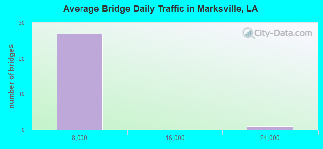
- 51,727Total average daily traffic
- 2,787Total average daily truck traffic
- 59,146Total future (year 2036) average daily traffic
- National Bridge Inventory (NBI) Registered Bridges for Marksville
- No street view available for this location
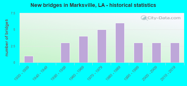
- New bridges - historical statistics
- 11930-1939
- 31950-1959
- 41960-1969
- 51970-1979
- 61980-1989
- 31990-1999
- 32000-2009
- 32010-2019
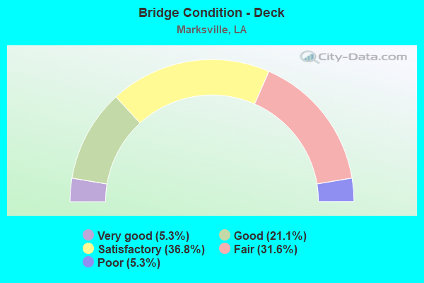
- Bridge Condition - Deck
- 5.3%Very good
- 21.1%Good
- 36.8%Satisfactory
- 31.6%Fair
- 5.3%Poor
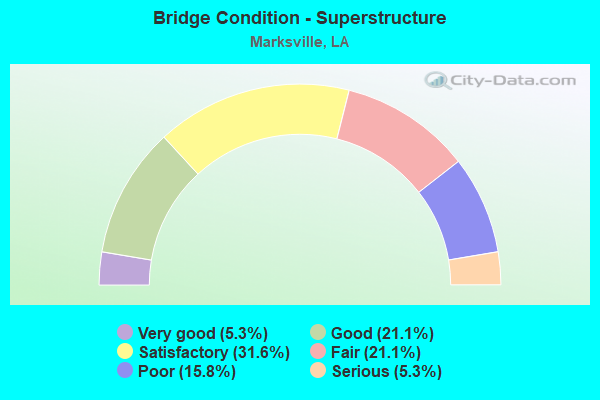
- Bridge Condition - Superstructure
- 5.3%Very good
- 21.1%Good
- 31.6%Satisfactory
- 21.1%Fair
- 15.8%Poor
- 5.3%Serious
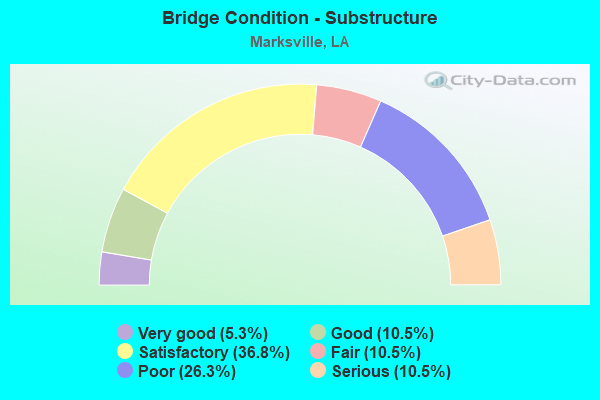
- Bridge Condition - Substructure
- 5.3%Very good
- 10.5%Good
- 36.8%Satisfactory
- 10.5%Fair
- 26.3%Poor
- 10.5%Serious
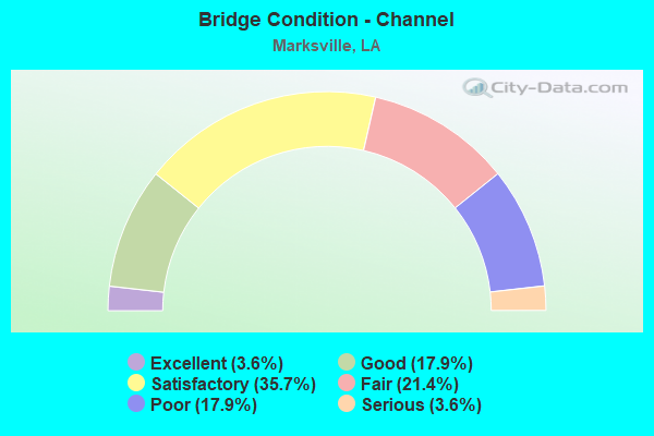
- Bridge Condition - Channel
- 3.6%Excellent
- 17.9%Good
- 35.7%Satisfactory
- 21.4%Fair
- 17.9%Poor
- 3.6%Serious
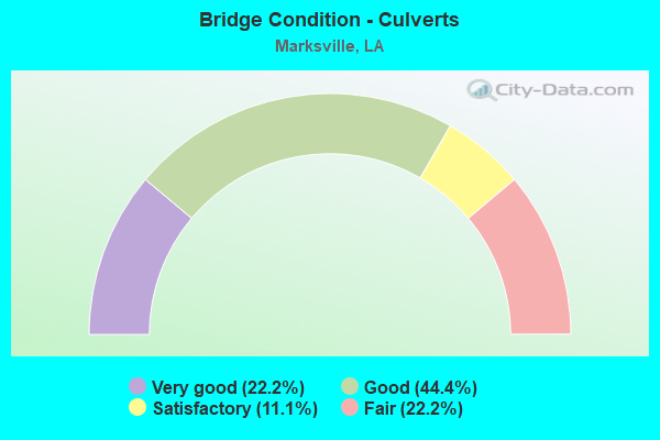
- Bridge Condition - Culverts
- 22.2%Very good
- 44.4%Good
- 11.1%Satisfactory
- 22.2%Fair
Find on map >> Show street view
Structure Number: S601, Location: 2 KM S OF MARKSVILLE, LA (Lat: 31.110806, Lng: -92.057528), Route carried "on" structure: Federal lands road 3004, Year Built: 1999, Status: Open, Structure Length: 0.88m (2.89ft), Average Daily Traffic: 100 (year 2021), Truck Traffic: 1%, Average Future Daily Traffic: 120 (year 2041), Design Load: HS 20, Features Intersected: TUNICA CREEK
Minimum Vertical Clearance: 30+ m (98+ ft), Kilometerpoint: 0.640, Lanes on structure: 2, Owner: Bureau of Indian Affairs, Approaching Roadway Width: 6.5m (21.3ft), Material/Design: Concrete, Design/Construction: Culvert, Number Of Spans In Main Unit: 2, Length of Maximum Span: 4.3m (14.1ft), Curb-To-Curb Width: 9.7m (31.8ft), Out-to-Out Width: 9.7m (31.8ft)
Condition: Channel: Good, Culverts: Very good, Operating Rating: 43.2 metric tons, Method Used To Determine Operating Rating: Allowable Stress (AS), Inventory Rating: 34.2 metric tons, Method Used To Determine Inventory Rating: Allowable Stress (AS), Structural Evaluation: Equal to present desirable criteria, Deck Geometry: Better than present minimum criteria, Waterway Adequacy: Equal to present desirable criteria, Approach Roadway Alignment: Equal to present desirable criteria, Designated Inspection Frequency: Every 24 months, Inspection Date: Febuary 2021
Find on map >> Show street view
Structure Number: S50336B0609, Location: IN MARKSVILLE, LA (Lat: 31.109397, Lng: -92.058653), Route carried "on" structure: Federal lands road 3015, Year Built: 2015, Status: Open, Structure Length: 7.95m (26.08ft), Average Daily Traffic: 350 (year 2021), Truck Traffic: 10%, Average Future Daily Traffic: 410 (year 2041), Features Intersected: COULLE DE GRUES
Minimum Vertical Clearance: 10.30m (33.79ft), Kilometerpoint: 0.265, Lanes on structure: 2, Owner: Bureau of Indian Affairs, Approaching Roadway Width: 10.3m (33.8ft), Material/Design: Prestressed concrete, Design/Construction: Stringer/Multi-beam, Number Of Spans In Main Unit: 1, Number Of Approach Spans: 10, Length of Maximum Span: 18.3m (60.0ft), Curb or Sidewalk Widths: Left: 0.1m (0.3ft), Right: 0.1m (0.3ft), Curb-To-Curb Width: 10.3m (33.8ft), Out-to-Out Width: 11.5m (37.7ft)
Condition: Deck: Very good, Superstructure: Very good, Substructure: Very good, Channel: Excellent, Operating Rating: 44.6 metric tons, Method Used To Determine Operating Rating: Load and Resistance Factor (LRFR), Inventory Rating: 34.4 metric tons, Method Used To Determine Inventory Rating: Load and Resistance Factor (LRFR), Structural Evaluation: Equal to present desirable criteria, Deck Geometry: Better than present minimum criteria, Waterway Adequacy: Superior to present desirable criteria, Approach Roadway Alignment: Equal to present desirable criteria, Designated Inspection Frequency: Every 24 months, Inspection Date: Febuary 2021, Deck Structure Type: Concrete Cast-file-Place
Find on map >> Show street view
Structure Number: S50336B061, Location: .2KM EAST OF STATE HWY107 (Lat: 31.101953, Lng: -92.059339), Route carried "on" structure: Federal lands road 3015, Year Built: 2016, Status: Open, Structure Length: 1.25m (4.10ft), Average Daily Traffic: 250 (year 2021), Truck Traffic: 10%, Average Future Daily Traffic: 292 (year 2041), Features Intersected: UNKNOWN STREAM
Minimum Vertical Clearance: 30+ m (98+ ft), Kilometerpoint: 0.200, Lanes on structure: 2, Owner: Bureau of Indian Affairs, Approaching Roadway Width: 8.0m (26.2ft), Skew: 6 degrees, Material/Design: Prestressed concrete, Design/Construction: Culvert, Number Of Spans In Main Unit: 1, Length of Maximum Span: 12.5m (41.0ft), Curb or Sidewalk Widths: Left: 1.9m (6.2ft), Right: 1.9m (6.2ft), Curb-To-Curb Width: 8.0m (26.2ft), Out-to-Out Width: 11.8m (38.7ft)
Condition: Channel: Good, Culverts: Very good, Operating Rating: 44.5 metric tons, Method Used To Determine Operating Rating: Load and Resistance Factor (LRFR), Inventory Rating: 32.7 metric tons, Method Used To Determine Inventory Rating: Load and Resistance Factor (LRFR), Structural Evaluation: Equal to present desirable criteria, Deck Geometry: Somewhat better than minimum adequacy, Waterway Adequacy: Better than present minimum criteria, Approach Roadway Alignment: Equal to present desirable criteria, Designated Inspection Frequency: Every 24 months, Inspection Date: Febuary 2021
Find on map >> Show street view
Structure Number: 80500000800083, Location: 0.2 MI. SOUTH OF NORMAND (Lat: 31.076400, Lng: -92.077100), Route carried "on" structure: County highway , Year Built: 2013, Status: Open, Structure Length: 0.64m (2.10ft), Average Daily Traffic: 267 (year 2005), Average Future Daily Traffic: 389 (year 2036), Design Load: HS 20, Features Intersected: DRAINAGE DITCH, Facility Carried by Structure: Schexnyder Rd
Minimum Vertical Clearance: 30+ m (98+ ft), Kilometerpoint: 1.197, Lanes on structure: 2, Owner: County Highway Agency, Approaching Roadway Width: 5.2m (17.1ft), Skew: 37 degrees, Material/Design: Concrete, Design/Construction: Culvert, Number Of Spans In Main Unit: 2, Length of Maximum Span: 2.7m (8.9ft)
Condition: Channel: Fair, Culverts: Good, Operating Rating: 41.8 metric tons, Method Used To Determine Operating Rating: Load and Resistance Factor Rating (LRFR) rating reported by rating factor(RF) method using HL-93 loadings, Inventory Rating: 32.4 metric tons, Method Used To Determine Inventory Rating: Load and Resistance Factor Rating (LRFR) rating reported by rating factor(RF) method using HL-93 loadings, Structural Evaluation: Better than present minimum criteria, Waterway Adequacy: Equal to present minimum criteria, Approach Roadway Alignment: Better than present minimum criteria, Designated Inspection Frequency: Every 24 months, Inspection Date: Febuary 2021, Deck Structure Type: Concrete Precast Panels
Find on map >> Show street view
Structure Number: 80500000800123, Location: 0.08 MI. NORTH OF LA 1192 (Lat: 31.191839, Lng: -92.079900), Route carried "on" structure: County highway , Year Built: 2009, Status: Open, Structure Length: 0.64m (2.10ft), Average Daily Traffic: 400 (year 2001), Average Future Daily Traffic: 584 (year 2036), Design Load: HS 20, Features Intersected: JOHNSON BAYOU, Facility Carried by Structure: Johnson Rd
Minimum Vertical Clearance: 30+ m (98+ ft), Kilometerpoint: 1.941, Lanes on structure: 2, Owner: County Highway Agency, Approaching Roadway Width: 7.9m (25.9ft), Skew: 37 degrees, Material/Design: Concrete, Design/Construction: Culvert, Number Of Spans In Main Unit: 3, Length of Maximum Span: 2.1m (6.9ft)
Condition: Channel: Satisfactory, Culverts: Good, Operating Rating: 42.1 metric tons, Method Used To Determine Operating Rating: Load and Resistance Factor Rating (LRFR) rating reported by rating factor(RF) method using HL-93 loadings, Inventory Rating: 32.4 metric tons, Method Used To Determine Inventory Rating: Load and Resistance Factor Rating (LRFR) rating reported by rating factor(RF) method using HL-93 loadings, Structural Evaluation: Better than present minimum criteria, Waterway Adequacy: Meets minimum limits, Approach Roadway Alignment: Somewhat better than minimum adequacy, Designated Inspection Frequency: Every 24 months, Inspection Date: March 2021, Deck Structure Type: Concrete Precast Panels
Find on map >> Show street view
Structure Number: 80500000800126, Location: 0.49 MI. NE OF LA 1192 (Lat: 31.175881, Lng: -92.059900), Route carried "on" structure: County highway , Year Built: 2009, Status: Open, Structure Length: 3.60m (11.81ft), Average Daily Traffic: 100 (year 2001), Average Future Daily Traffic: 146 (year 2036), Design Load: HS 20, Features Intersected: JOHNSON BAYOU, Facility Carried by Structure: Fort Derussy Rd
Minimum Vertical Clearance: 30+ m (98+ ft), Kilometerpoint: 0.848, Lanes on structure: 2, Owner: County Highway Agency, Approaching Roadway Width: 7.3m (24.0ft), Skew: 30 degrees, Material/Design: Concrete, Design/Construction: Slab, Number Of Spans In Main Unit: 6, Length of Maximum Span: 6.1m (20.0ft), Curb-To-Curb Width: 7.3m (24.0ft), Out-to-Out Width: 8.2m (26.9ft)
Condition: Deck: Good, Superstructure: Good, Substructure: Good, Channel: Good, Operating Rating: 44.4 metric tons, Method Used To Determine Operating Rating: Load and Resistance Factor Rating (LRFR) rating reported by rating factor(RF) method using HL-93 loadings, Inventory Rating: 34.3 metric tons, Method Used To Determine Inventory Rating: Load and Resistance Factor Rating (LRFR) rating reported by rating factor(RF) method using HL-93 loadings, Structural Evaluation: Better than present minimum criteria, Deck Geometry: Equal to present minimum criteria, Waterway Adequacy: Equal to present minimum criteria, Approach Roadway Alignment: Equal to present minimum criteria, Designated Inspection Frequency: Every 24 months, Inspection Date: March 2021, Deck Structure Type: Concrete Cast-file-Place, Wearing Surface/Protective System: Wearing Surface: Monolithic Concrete
Find on map >> Show street view
Structure Number: 80500330107911, Location: 7.91 MILES NORTH OF LA 29 (Lat: 31.020050, Lng: -92.148100), Route carried "on" structure: State highway 115, Year Built: 1950, Status: Open, Structure Length: 10.36m (33.99ft), Average Daily Traffic: 3,100 (year 2016), Truck Traffic: 15%, Average Future Daily Traffic: 4,672 (year 2036), Design Load: H 15, Features Intersected: BAYOU DULAC
Minimum Vertical Clearance: 30+ m (98+ ft), Kilometerpoint: 12.719, Lanes on structure: 2, Base Highway Network: Yes (Inventory Route: 33-01-1, Subroute: 10), Owner: State Highway Agency, Approaching Roadway Width: 9.1m (29.9ft), Skew: 30 degrees, Material/Design: Steel, Design/Construction: Stringer/Multi-beam, Number Of Spans In Main Unit: 8, Length of Maximum Span: 18.3m (60.0ft), Curb-To-Curb Width: 7.3m (24.0ft), Out-to-Out Width: 8.9m (29.2ft)
Condition: Deck: Satisfactory, Superstructure: Satisfactory, Substructure: Satisfactory, Channel: Satisfactory, Operating Rating: 32.1 metric tons, Method Used To Determine Operating Rating: Load and Resistance Factor Rating (LRFR) rating reported by rating factor(RF) method using HL-93 loadings, Inventory Rating: 24.6 metric tons, Method Used To Determine Inventory Rating: Load and Resistance Factor Rating (LRFR) rating reported by rating factor(RF) method using HL-93 loadings, Structural Evaluation: Equal to present minimum criteria, Deck Geometry: High priority of replacement, Waterway Adequacy: Better than present minimum criteria, Approach Roadway Alignment: Meets minimum limits, Length Of Structure Improvement: 11.28m (37.01ft), Designated Inspection Frequency: Every 24 months, Underwater Inspection Frequency: Every 60 months, Inspection Date: May 2020, Underwater Inspection Date: April 2018, Bridge Improvement Cost: $962,000, Total Project Cost: $1,443,000 ( Estimate for 2016), Deck Structure Type: Concrete Cast-file-Place, Wearing Surface/Protective System: Wearing Surface: Monolithic Concrete
Find on map >> Show street view
Structure Number: 80500330116011, Location: 1.18 MILES SOUTH OF LA 1 (Lat: 31.108739, Lng: -92.082400), Route carried "on" structure: State highway 115, Year Built: 1961, Status: Open, Structure Length: 4.33m (14.21ft), Average Daily Traffic: 5,200 (year 2016), Truck Traffic: 4%, Average Future Daily Traffic: 7,738 (year 2036), Design Load: HS 20, Features Intersected: COULEE DES GRUES
Minimum Vertical Clearance: 30+ m (98+ ft), Kilometerpoint: 25.526, Lanes on structure: 2, Owner: State Highway Agency, Approaching Roadway Width: 9.1m (29.9ft), Skew: 33 degrees, Material/Design: Concrete, Design/Construction: Slab, Number Of Spans In Main Unit: 7, Length of Maximum Span: 6.1m (20.0ft), Curb-To-Curb Width: 8.6m (28.2ft), Out-to-Out Width: 10.2m (33.5ft)
Condition: Deck: Satisfactory, Superstructure: Satisfactory, Substructure: Satisfactory, Channel: Poor, Operating Rating: 41.7 metric tons, Method Used To Determine Operating Rating: Load Factor (LF), Inventory Rating: 24.5 metric tons, Method Used To Determine Inventory Rating: Load Factor (LF), Structural Evaluation: Equal to present minimum criteria, Deck Geometry: High priority of replacement, Waterway Adequacy: Better than present minimum criteria, Approach Roadway Alignment: Somewhat better than minimum adequacy, Length Of Structure Improvement: 5.24m (17.19ft), Designated Inspection Frequency: Every 24 months, Underwater Inspection Frequency: Every 60 months, Inspection Date: January 2022, Underwater Inspection Date: April 2018, Bridge Improvement Cost: $447,000, Total Project Cost: $670,000 ( Estimate for 2016), Deck Structure Type: Concrete Cast-file-Place, Wearing Surface/Protective System: Wearing Surface: Bituminous
Find on map >> Show street view
Structure Number: 80500520700001, Location: 1.71 MI. SOUTH OF LA 1191 (Lat: 31.133319, Lng: -92.083000), Route carried "on" structure: State highway 1, Year Built: 1970, Status: Open, Structure Length: 2.07m (6.79ft), Average Daily Traffic: 7,400 (year 2016), Truck Traffic: 4%, Average Future Daily Traffic: 10,950 (year 2036), Design Load: HS 20, Features Intersected: BAYOU PEROT
Minimum Vertical Clearance: 30+ m (98+ ft), Kilometerpoint: 0.016, Lanes on structure: 4, Owner: State Highway Agency, Approaching Roadway Width: 20.7m (67.9ft), Skew: 34 degrees, Material/Design: Concrete, Design/Construction: Culvert, Number Of Spans In Main Unit: 5, Length of Maximum Span: 3.0m (9.8ft), Curb-To-Curb Width: 18.0m (59.1ft), Out-to-Out Width: 30.8m (101.0ft)
Condition: Channel: Satisfactory, Culverts: Good, Operating Rating: 42.1 metric tons, Method Used To Determine Operating Rating: Load and Resistance Factor Rating (LRFR) rating reported by rating factor(RF) method using HL-93 loadings, Inventory Rating: 32.4 metric tons, Method Used To Determine Inventory Rating: Load and Resistance Factor Rating (LRFR) rating reported by rating factor(RF) method using HL-93 loadings, Structural Evaluation: Better than present minimum criteria, Deck Geometry: Somewhat better than minimum adequacy, Waterway Adequacy: Better than present minimum criteria, Approach Roadway Alignment: Better than present minimum criteria, Designated Inspection Frequency: Every 24 months, Inspection Date: January 2022, Deck Structure Type: Concrete Cast-file-Place
Find on map >> Show street view
Structure Number: 80500523010031, Location: 0.6 MILE SOUTH OF LA 452 (Lat: 31.109269, Lng: -92.063700), Route carried "on" structure: State highway 1, Year Built: 1931, Status: Open, Structure Length: 1.10m (3.61ft), Average Daily Traffic: 23,500 (year 2016), Truck Traffic: 4%, Average Future Daily Traffic: 18,104 (year 2036), Design Load: H 15, Features Intersected: COULEE DES GRUE
Minimum Vertical Clearance: 30+ m (98+ ft), Kilometerpoint: 16.243, Lanes on structure: 5, Owner: State Highway Agency, Approaching Roadway Width: 14.3m (46.9ft), Skew: 30 degrees, Material/Design: Concrete, Design/Construction: Culvert, Number Of Spans In Main Unit: 3, Length of Maximum Span: 2.4m (7.9ft)
Condition: Channel: Good, Culverts: Satisfactory, Operating Rating: 42.1 metric tons, Method Used To Determine Operating Rating: Load and Resistance Factor Rating (LRFR) rating reported by rating factor(RF) method using HL-93 loadings, Inventory Rating: 32.4 metric tons, Method Used To Determine Inventory Rating: Load and Resistance Factor Rating (LRFR) rating reported by rating factor(RF) method using HL-93 loadings, Structural Evaluation: Equal to present minimum criteria, Waterway Adequacy: Better than present minimum criteria, Approach Roadway Alignment: Better than present minimum criteria, Designated Inspection Frequency: Every 24 months, Inspection Date: January 2022, Deck Structure Type: Concrete Cast-file-Place
Find on map >> Show street view
Structure Number: 80501430103311, Location: 3.31 MI. NORTH OF LA 1190 (Lat: 31.161511, Lng: -92.053000), Route carried "on" structure: State highway 452, Year Built: 1953, Status: Open, Structure Length: 1.22m (4.00ft), Average Daily Traffic: 960 (year 2016), Truck Traffic: 14%, Average Future Daily Traffic: 1,401 (year 2036), Design Load: H 15, Features Intersected: BAYOU ROUGE
Minimum Vertical Clearance: 30+ m (98+ ft), Kilometerpoint: 5.279, Lanes on structure: 2, Owner: State Highway Agency, Approaching Roadway Width: 7.9m (25.9ft), Skew: 30 degrees, Material/Design: Concrete, Design/Construction: Tee Beam, Number Of Spans In Main Unit: 2, Length of Maximum Span: 6.1m (20.0ft), Curb-To-Curb Width: 6.1m (20.0ft), Out-to-Out Width: 6.6m (21.7ft)
Condition: Deck: Satisfactory, Superstructure: Satisfactory, Substructure: Satisfactory, Channel: Satisfactory, Operating Rating: 29.8 metric tons, Method Used To Determine Operating Rating: Load and Resistance Factor Rating (LRFR) rating reported by rating factor(RF) method using HL-93 loadings, Inventory Rating: 20.1 metric tons, Method Used To Determine Inventory Rating: Load and Resistance Factor Rating (LRFR) rating reported by rating factor(RF) method using HL-93 loadings, Structural Evaluation: Somewhat better than minimum adequacy, Deck Geometry: High priority of corrective action, Waterway Adequacy: Better than present minimum criteria, Approach Roadway Alignment: Meets minimum limits, Length Of Structure Improvement: 1.92m (6.30ft), Designated Inspection Frequency: Every 24 months, Inspection Date: January 2022, Bridge Improvement Cost: $163,000, Total Project Cost: $244,000 ( Estimate for 2016), Deck Structure Type: Concrete Cast-file-Place, Wearing Surface/Protective System: Wearing Surface: Bituminous
Find on map >> Show street view
Structure Number: 80501430103511, Location: 1.96 MI. NORTH OF LA 1190 (Lat: 31.163889, Lng: -92.050900), Route carried "on" structure: State highway 452, Year Built: 1953, Status: Open, Structure Length: 1.86m (6.10ft), Average Daily Traffic: 960 (year 2016), Truck Traffic: 14%, Average Future Daily Traffic: 1,401 (year 2036), Design Load: H 15, Features Intersected: JOHNSON BAYOU
Minimum Vertical Clearance: 30+ m (98+ ft), Kilometerpoint: 5.610, Lanes on structure: 2, Owner: State Highway Agency, Approaching Roadway Width: 7.9m (25.9ft), Skew: 30 degrees, Material/Design: Concrete, Design/Construction: Tee Beam, Number Of Spans In Main Unit: 3, Length of Maximum Span: 6.1m (20.0ft), Curb-To-Curb Width: 6.1m (20.0ft), Out-to-Out Width: 7.6m (24.9ft)
Condition: Deck: Satisfactory, Superstructure: Satisfactory, Substructure: Satisfactory, Channel: Satisfactory, Operating Rating: 24.6 metric tons, Method Used To Determine Operating Rating: Load and Resistance Factor Rating (LRFR) rating reported by rating factor(RF) method using HL-93 loadings, Inventory Rating: 16.5 metric tons, Method Used To Determine Inventory Rating: Load and Resistance Factor Rating (LRFR) rating reported by rating factor(RF) method using HL-93 loadings, Structural Evaluation: Meets minimum limits, Deck Geometry: High priority of corrective action, Waterway Adequacy: Better than present minimum criteria, Approach Roadway Alignment: Better than present minimum criteria, Length Of Structure Improvement: 2.59m (8.50ft), Designated Inspection Frequency: Every 24 months, Inspection Date: January 2022, Bridge Improvement Cost: $221,000, Total Project Cost: $331,000 ( Estimate for 2016), Deck Structure Type: Concrete Cast-file-Place, Wearing Surface/Protective System: Wearing Surface: Bituminous
Find on map >> Show street view
Structure Number: 80508050200021, Location: 0.02 M W OF S JCT LA 107 (Lat: 30.928719, Lng: -91.948200), Route carried "on" structure: State highway 1179, Year Built: 1986, Status: Open, Structure Length: 1.74m (5.71ft), Average Daily Traffic: 1,140 (year 2016), Truck Traffic: 10%, Average Future Daily Traffic: 1,620 (year 2036), Design Load: HS 20, Features Intersected: BAYOU JACK
Minimum Vertical Clearance: 30+ m (98+ ft), Kilometerpoint: 0.029, Lanes on structure: 2, Owner: State Highway Agency, Approaching Roadway Width: 7.9m (25.9ft), Skew: 30 degrees, Material/Design: Concrete, Design/Construction: Slab, Number Of Spans In Main Unit: 3, Length of Maximum Span: 5.8m (19.0ft), Curb-To-Curb Width: 8.7m (28.5ft), Out-to-Out Width: 9.4m (30.8ft)
Condition: Deck: Good, Superstructure: Good, Substructure: Good, Channel: Satisfactory, Operating Rating: 89.8 metric tons, Method Used To Determine Operating Rating: Load Factor (LF), Inventory Rating: 58.0 metric tons, Method Used To Determine Inventory Rating: Load Factor (LF), Structural Evaluation: Better than present minimum criteria, Deck Geometry: Somewhat better than minimum adequacy, Waterway Adequacy: Better than present minimum criteria, Approach Roadway Alignment: Meets minimum limits, Designated Inspection Frequency: Every 24 months, Underwater Inspection Frequency: Every 60 months, Inspection Date: Febuary 2020, Underwater Inspection Date: April 2018, Deck Structure Type: Concrete Precast Panels, Wearing Surface/Protective System: Wearing Surface: Monolithic Concrete
Find on map >> Show street view
Structure Number: 80508050603631, Location: 3.63 MI. N OF N JCT LA 10 (Lat: 31.174150, Lng: -92.065500), Route carried "on" structure: State highway 1192, Year Built: 2004, Status: Open, Structure Length: 0.64m (2.10ft), Average Daily Traffic: 590 (year 2016), Truck Traffic: 10%, Average Future Daily Traffic: 861 (year 2036), Design Load: HS 20, Features Intersected: JOHNSON CANAL
Minimum Vertical Clearance: 30+ m (98+ ft), Kilometerpoint: 5.868, Lanes on structure: 2, Owner: State Highway Agency, Approaching Roadway Width: 6.1m (20.0ft), Skew: 30 degrees, Material/Design: Concrete, Design/Construction: Culvert, Number Of Spans In Main Unit: 2, Length of Maximum Span: 3.0m (9.8ft), Curb-To-Curb Width: 7.8m (25.6ft), Out-to-Out Width: 26.2m (86.0ft)
Condition: Channel: Satisfactory, Culverts: Good, Operating Rating: 42.1 metric tons, Method Used To Determine Operating Rating: Load and Resistance Factor Rating (LRFR) rating reported by rating factor(RF) method using HL-93 loadings, Inventory Rating: 32.4 metric tons, Method Used To Determine Inventory Rating: Load and Resistance Factor Rating (LRFR) rating reported by rating factor(RF) method using HL-93 loadings, Structural Evaluation: Better than present minimum criteria, Deck Geometry: Meets minimum limits, Waterway Adequacy: Equal to present desirable criteria, Approach Roadway Alignment: Equal to present desirable criteria, Designated Inspection Frequency: Every 24 months, Inspection Date: January 2022, Deck Structure Type: Concrete Cast-file-Place
Find on map >> Show street view
Structure Number: 80508053200421, Location: 0.23 MILES EAST OF LA 452 (Lat: 31.137281, Lng: -92.055100), Route carried "on" structure: State highway 1190, Year Built: 1970, Status: Open, Structure Length: 1.80m (5.91ft), Average Daily Traffic: 4,700 (year 2016), Truck Traffic: 8%, Average Future Daily Traffic: 6,716 (year 2036), Design Load: HS 20, Features Intersected: DRAINAGE DITCH
Minimum Vertical Clearance: 30+ m (98+ ft), Kilometerpoint: 0.690, Lanes on structure: 2, Owner: State Highway Agency, Approaching Roadway Width: 9.1m (29.9ft), Skew: 34 degrees, Material/Design: Concrete, Design/Construction: Slab, Number Of Spans In Main Unit: 3, Length of Maximum Span: 5.8m (19.0ft), Curb-To-Curb Width: 8.5m (27.9ft), Out-to-Out Width: 9.4m (30.8ft)
Condition: Deck: Fair, Superstructure: Fair, Substructure: Poor, Channel: Fair, Operating Rating: 28.2 metric tons, Method Used To Determine Operating Rating: Load and Resistance Factor Rating (LRFR) rating reported by rating factor(RF) method using HL-93 loadings, Inventory Rating: 21.7 metric tons, Method Used To Determine Inventory Rating: Load and Resistance Factor Rating (LRFR) rating reported by rating factor(RF) method using HL-93 loadings, Structural Evaluation: Meets minimum limits, Deck Geometry: Meets minimum limits, Waterway Adequacy: Better than present minimum criteria, Approach Roadway Alignment: Better than present minimum criteria, Length Of Structure Improvement: 2.50m (8.20ft), Designated Inspection Frequency: Every 24 months, Other Special Inspection Frequency: Every 12 months, Inspection Date: January 2022, Other Special Inspection Date: January 2021, Bridge Improvement Cost: $213,000, Total Project Cost: $319,000 ( Estimate for 2016), Deck Structure Type: Concrete Precast Panels, Wearing Surface/Protective System: Wearing Surface: Bituminous
Find on map >> Show street view
Structure Number: 80531000915801, Location: 2.5 MI NE OF PLAUCHEVILLE (Lat: 30.999889, Lng: -91.966700), Route carried "on" structure: County highway , Year Built: 1983, Status: Open, Structure Length: 6.43m (21.10ft), Average Daily Traffic: 570 (year 1981), Average Future Daily Traffic: 832 (year 2036), Design Load: HS 20, Features Intersected: BAYOU DES GLAISES, Facility Carried by Structure: Moreau-Plauche Ctf
Minimum Vertical Clearance: 30+ m (98+ ft), Kilometerpoint: 1.336, Lanes on structure: 2, Owner: County Highway Agency, Approaching Roadway Width: 6.4m (21.0ft), Skew: 36 degrees, Material/Design: Concrete, Design/Construction: Slab, Number Of Spans In Main Unit: 11, Length of Maximum Span: 5.8m (19.0ft), Curb-To-Curb Width: 8.5m (27.9ft), Out-to-Out Width: 9.4m (30.8ft)
Condition: Deck: Good, Superstructure: Good, Substructure: Satisfactory, Channel: Serious, Operating Rating: 40.5 metric tons, Method Used To Determine Operating Rating: Load and Resistance Factor Rating (LRFR) rating reported by rating factor(RF) method using HL-93 loadings, Inventory Rating: 31.4 metric tons, Method Used To Determine Inventory Rating: Load and Resistance Factor Rating (LRFR) rating reported by rating factor(RF) method using HL-93 loadings, Structural Evaluation: Equal to present minimum criteria, Deck Geometry: Somewhat better than minimum adequacy, Waterway Adequacy: Better than present minimum criteria, Approach Roadway Alignment: Somewhat better than minimum adequacy, Designated Inspection Frequency: Every 24 months, Underwater Inspection Frequency: Every 60 months, Inspection Date: January 2021, Underwater Inspection Date: April 2018, Deck Structure Type: Concrete Cast-file-Place, Wearing Surface/Protective System: Wearing Surface: Monolithic Concrete
Find on map >> Show street view
Structure Number: 80531046920441, Location: 1.24 MI. N. OF LARGE RD. (Lat: 31.077039, Lng: -92.075900), Route carried "on" structure: County highway , Year Built: 1983, Status: Posted for load, Structure Length: 0.94m (3.08ft), Average Daily Traffic: 90 (year 1974), Average Future Daily Traffic: 131 (year 2036), Design Load: H 15, Features Intersected: DRAINAGE DITCH, Facility Carried by Structure: Normand Rd
Minimum Vertical Clearance: 30+ m (98+ ft), Kilometerpoint: 2.091, Lanes on structure: 2, Owner: County Highway Agency, Approaching Roadway Width: 5.5m (18.0ft), Skew: 32 degrees, Material/Design: Wood or Timber, Design/Construction: Stringer/Multi-beam, Number Of Spans In Main Unit: 2, Length of Maximum Span: 4.6m (15.1ft), Curb-To-Curb Width: 5.5m (18.0ft), Out-to-Out Width: 5.8m (19.0ft)
Condition: Deck: Fair, Superstructure: Serious, Substructure: Serious, Channel: Fair, Operating Rating: 20.0 metric tons, Method Used To Determine Operating Rating: Allowable Stress (AS), Inventory Rating: 14.5 metric tons, Method Used To Determine Inventory Rating: Allowable Stress (AS), Structural Evaluation: High priority of corrective action, Deck Geometry: Meets minimum limits, Waterway Adequacy: Meets minimum limits, Approach Roadway Alignment: Better than present minimum criteria, Bridge Posting: Required (Relationship of Operating Rating to Maximum Legal Load: 20.0 - 29.9% below), Designated Inspection Frequency: Every 24 months, Other Special Inspection Frequency: Every 12 months, Inspection Date: Febuary 2021, Other Special Inspection Date: Febuary 2020, Deck Structure Type: Wood or Timber, Wearing Surface/Protective System: Wearing Surface: Wood or Timber
Find on map >> Show street view
Structure Number: 80531068920621, Location: 2.11 M. E. OF END LA 1194 (Lat: 31.113250, Lng: -92.102000), Route carried "on" structure: County highway , Year Built: 1960, Status: Posted for load, Structure Length: 1.52m (4.99ft), Average Daily Traffic: 100 (year 2020), Average Future Daily Traffic: 110 (year 2040), Design Load: H 15, Features Intersected: DRAINAGE CANAL, Facility Carried by Structure: Lil California Rd
Minimum Vertical Clearance: 30+ m (98+ ft), Kilometerpoint: 3.380, Lanes on structure: 2, Owner: County Highway Agency, Approaching Roadway Width: 9.1m (29.9ft), Skew: 30 degrees, Material/Design: Wood or Timber, Design/Construction: Stringer/Multi-beam, Number Of Spans In Main Unit: 4, Length of Maximum Span: 4.0m (13.1ft), Curb-To-Curb Width: 6.2m (20.3ft), Out-to-Out Width: 6.6m (21.7ft)
Condition: Deck: Poor, Superstructure: Fair, Substructure: Poor, Channel: Fair, Operating Rating: 20.0 metric tons, Method Used To Determine Operating Rating: Allowable Stress (AS), Inventory Rating: 14.5 metric tons, Method Used To Determine Inventory Rating: Allowable Stress (AS), Structural Evaluation: Meets minimum limits, Deck Geometry: Somewhat better than minimum adequacy, Waterway Adequacy: Better than present minimum criteria, Approach Roadway Alignment: Equal to present minimum criteria, Bridge Posting: Required (Relationship of Operating Rating to Maximum Legal Load: 20.0 - 29.9% below), Length Of Structure Improvement: 2.23m (7.32ft), Designated Inspection Frequency: Every 24 months, Other Special Inspection Frequency: Every 12 months, Inspection Date: Febuary 2021, Other Special Inspection Date: Febuary 2020, Bridge Improvement Cost: $132,000, Total Project Cost: $198,000 ( Estimate for 2016), Deck Structure Type: Wood or Timber, Wearing Surface/Protective System: Wearing Surface: Other
Find on map >> Show street view
Structure Number: 80531075920151, Location: 3.0M EAST LA 1190/LA 452 (Lat: 31.128950, Lng: -92.014200), Route carried "on" structure: County highway , Year Built: 1970, Status: Posted for load, Structure Length: 1.49m (4.89ft), Average Daily Traffic: 40 (year 2020), Average Future Daily Traffic: 44 (year 2040), Design Load: H 10, Features Intersected: BOGGY BAYOU CANAL, Facility Carried by Structure: Chuck Davis Rd
Minimum Vertical Clearance: 30+ m (98+ ft), Kilometerpoint: 0.000, Lanes on structure: 2, Owner: County Highway Agency, Approaching Roadway Width: 4.9m (16.1ft), Skew: 30 degrees, Material/Design: Wood or Timber, Design/Construction: Stringer/Multi-beam, Number Of Spans In Main Unit: 3, Length of Maximum Span: 5.8m (19.0ft), Curb-To-Curb Width: 5.2m (17.1ft), Out-to-Out Width: 5.5m (18.0ft)
Condition: Deck: Satisfactory, Superstructure: Fair, Substructure: Fair, Channel: Fair, Operating Rating: 23.6 metric tons, Method Used To Determine Operating Rating: Allowable Stress (AS), Inventory Rating: 18.1 metric tons, Method Used To Determine Inventory Rating: Allowable Stress (AS), Structural Evaluation: Somewhat better than minimum adequacy, Deck Geometry: High priority of corrective action, Waterway Adequacy: Meets minimum limits, Approach Roadway Alignment: Somewhat better than minimum adequacy, Bridge Posting: Required (Relationship of Operating Rating to Maximum Legal Load: 0.1 - 9.9% below), Length Of Structure Improvement: 2.16m (7.09ft), Designated Inspection Frequency: Every 24 months, Inspection Date: Febuary 2021, Bridge Improvement Cost: $129,000, Total Project Cost: $193,000 ( Estimate for 2016), Deck Structure Type: Wood or Timber, Wearing Surface/Protective System: Wearing Surface: Wood or Timber
Find on map >> Show street view
Structure Number: 80531079920421, Location: MARKSVILLE, AVOYELLES PAR (Lat: 31.131761, Lng: -92.072500), Route carried "on" structure: County highway , Year Built: 1985, Status: Posted for load, Structure Length: 0.76m (2.49ft), Average Daily Traffic: 100 (year 1974), Average Future Daily Traffic: 146 (year 2036), Design Load: H 10, Features Intersected: BAYOU PEROT, Facility Carried by Structure: Foster Drive
Minimum Vertical Clearance: 30+ m (98+ ft), Kilometerpoint: 0.080, Lanes on structure: 2, Owner: City or Municipal Highway Agency, Approaching Roadway Width: 4.9m (16.1ft), Skew: 30 degrees, Material/Design: Wood or Timber, Design/Construction: Stringer/Multi-beam, Number Of Spans In Main Unit: 1, Length of Maximum Span: 7.3m (24.0ft), Curb-To-Curb Width: 5.8m (19.0ft), Out-to-Out Width: 6.1m (20.0ft)
Condition: Deck: Good, Superstructure: Good, Substructure: Fair, Channel: Satisfactory, Operating Rating: 19.0 metric tons, Method Used To Determine Operating Rating: Allowable Stress (AS), Inventory Rating: 13.6 metric tons, Method Used To Determine Inventory Rating: Allowable Stress (AS), Structural Evaluation: Meets minimum limits, Deck Geometry: Meets minimum limits, Waterway Adequacy: Equal to present minimum criteria, Approach Roadway Alignment: Equal to present minimum criteria, Bridge Posting: Required (Relationship of Operating Rating to Maximum Legal Load: 20.0 - 29.9% below), Length Of Structure Improvement: 1.37m (4.49ft), Designated Inspection Frequency: Every 24 months, Inspection Date: March 2021, Bridge Improvement Cost: $81,000, Total Project Cost: $121,000 ( Estimate for 2016), Deck Structure Type: Wood or Timber, Wearing Surface/Protective System: Wearing Surface: Wood or Timber
Find on map >> Show street view
Structure Number: 80531080920491, Location: 0.1 M. SE OF JCT LA 1 (Lat: 31.133519, Lng: -92.082600), Route carried "on" structure: County highway , Year Built: 1970, Status: Open, Structure Length: 1.25m (4.10ft), Average Daily Traffic: 310 (year 1974), Average Future Daily Traffic: 452 (year 2036), Design Load: HS 20, Features Intersected: DRAINAGE DITCH, Facility Carried by Structure: W Bon Tempt St
Minimum Vertical Clearance: 30+ m (98+ ft), Kilometerpoint: 0.000, Lanes on structure: 2, Owner: City or Municipal Highway Agency, Approaching Roadway Width: 12.8m (42.0ft), Skew: 30 degrees, Material/Design: Concrete, Design/Construction: Culvert, Number Of Spans In Main Unit: 6, Length of Maximum Span: 1.8m (5.9ft)
Condition: Channel: Satisfactory, Culverts: Fair, Operating Rating: 42.1 metric tons, Method Used To Determine Operating Rating: Load and Resistance Factor Rating (LRFR) rating reported by rating factor(RF) method using HL-93 loadings, Inventory Rating: 32.4 metric tons, Method Used To Determine Inventory Rating: Load and Resistance Factor Rating (LRFR) rating reported by rating factor(RF) method using HL-93 loadings, Structural Evaluation: Somewhat better than minimum adequacy, Waterway Adequacy: Better than present minimum criteria, Approach Roadway Alignment: Equal to present minimum criteria, Designated Inspection Frequency: Every 24 months, Inspection Date: March 2021, Deck Structure Type: Concrete Cast-file-Place
Find on map >> Show street view
Structure Number: 80531083920221, Location: 0.29 MI. SOUTH OF LA 1190 (Lat: 31.140519, Lng: -92.036600), Route carried "on" structure: County highway , Year Built: 1998, Status: Open, Structure Length: 7.53m (24.70ft), Average Daily Traffic: 550 (year 1974), Average Future Daily Traffic: 803 (year 2036), Design Load: HS 20, Features Intersected: LITTLE RIVER, Facility Carried by Structure: Spring Bayou Rd
Minimum Vertical Clearance: 30+ m (98+ ft), Kilometerpoint: 0.415, Lanes on structure: 2, Base Highway Network: Yes, Owner: County Highway Agency, Approaching Roadway Width: 7.3m (24.0ft), Skew: 30 degrees, Material/Design: Concrete, Design/Construction: Slab, Number Of Spans In Main Unit: 13, Length of Maximum Span: 5.8m (19.0ft), Curb-To-Curb Width: 8.5m (27.9ft), Out-to-Out Width: 9.4m (30.8ft)
Condition: Deck: Satisfactory, Superstructure: Satisfactory, Substructure: Satisfactory, Channel: Satisfactory, Operating Rating: 36.0 metric tons, Method Used To Determine Operating Rating: Load and Resistance Factor Rating (LRFR) rating reported by rating factor(RF) method using HL-93 loadings, Inventory Rating: 27.9 metric tons, Method Used To Determine Inventory Rating: Load and Resistance Factor Rating (LRFR) rating reported by rating factor(RF) method using HL-93 loadings, Structural Evaluation: Equal to present minimum criteria, Deck Geometry: Somewhat better than minimum adequacy, Waterway Adequacy: Equal to present desirable criteria, Approach Roadway Alignment: Somewhat better than minimum adequacy, Designated Inspection Frequency: Every 24 months, Underwater Inspection Frequency: Every 60 months, Inspection Date: Febuary 2021, Underwater Inspection Date: April 2018, Deck Structure Type: Concrete Cast-file-Place, Wearing Surface/Protective System: Wearing Surface: Monolithic Concrete
Find on map >> Show street view
Structure Number: 80531084920041, Location: 3 MI E. LA 1190 & LA 452 (Lat: 31.141800, Lng: -92.009500), Route carried "on" structure: County highway , Year Built: 1996, Status: Open, Structure Length: 3.47m (11.38ft), Average Daily Traffic: 250 (year 2020), Average Future Daily Traffic: 275 (year 2040), Design Load: HS 20, Features Intersected: LITTLE RIVER, Facility Carried by Structure: Boggy Bayou Rd
Minimum Vertical Clearance: 30+ m (98+ ft), Kilometerpoint: 1.986, Lanes on structure: 2, Owner: County Highway Agency, Approaching Roadway Width: 7.3m (24.0ft), Skew: 30 degrees, Material/Design: Concrete, Design/Construction: Slab, Number Of Spans In Main Unit: 6, Length of Maximum Span: 5.8m (19.0ft), Curb-To-Curb Width: 7.3m (24.0ft), Out-to-Out Width: 8.2m (26.9ft)
Condition: Deck: Satisfactory, Superstructure: Satisfactory, Substructure: Satisfactory, Channel: Good, Operating Rating: 47.6 metric tons, Method Used To Determine Operating Rating: Load and Resistance Factor Rating (LRFR) rating reported by rating factor(RF) method using HL-93 loadings, Inventory Rating: 36.9 metric tons, Method Used To Determine Inventory Rating: Load and Resistance Factor Rating (LRFR) rating reported by rating factor(RF) method using HL-93 loadings, Structural Evaluation: Equal to present minimum criteria, Deck Geometry: Somewhat better than minimum adequacy, Waterway Adequacy: Better than present minimum criteria, Approach Roadway Alignment: Equal to present minimum criteria, Designated Inspection Frequency: Every 24 months, Underwater Inspection Frequency: Every 60 months, Inspection Date: Febuary 2021, Underwater Inspection Date: September 2018, Deck Structure Type: Concrete Precast Panels, Wearing Surface/Protective System: Wearing Surface: Monolithic Concrete
Find on map >> Show street view
Structure Number: 80531089920531, Location: 0.73 M. NE OF JCT LA 1 (Lat: 31.148481, Lng: -92.088700), Route carried "on" structure: County highway , Year Built: 1984, Status: Open, Structure Length: 0.91m (2.99ft), Average Daily Traffic: 170 (year 1983), Average Future Daily Traffic: 248 (year 2036), Design Load: HS 20, Features Intersected: DRAINAGE DITCH, Facility Carried by Structure: Gum Ridge Rd
Minimum Vertical Clearance: 30+ m (98+ ft), Kilometerpoint: 1.181, Lanes on structure: 2, Owner: County Highway Agency, Approaching Roadway Width: 8.5m (27.9ft), Skew: 36 degrees, Material/Design: Steel, Design/Construction: Culvert, Number Of Spans In Main Unit: 4, Length of Maximum Span: 1.8m (5.9ft)
Condition: Channel: Poor, Culverts: Fair, Operating Rating: 49.6 metric tons, Method Used To Determine Operating Rating: Load and Resistance Factor Rating (LRFR) rating reported by rating factor(RF) method using HL-93 loadings, Inventory Rating: 48.3 metric tons, Method Used To Determine Inventory Rating: Load and Resistance Factor Rating (LRFR) rating reported by rating factor(RF) method using HL-93 loadings, Structural Evaluation: Somewhat better than minimum adequacy, Waterway Adequacy: Better than present minimum criteria, Approach Roadway Alignment: Better than present minimum criteria, Designated Inspection Frequency: Every 24 months, Inspection Date: March 2021
Find on map >> Show street view
Structure Number: 80531090920631, Location: 0.48 MILES NW OF JCT LA 1 (Lat: 31.151869, Lng: -92.103700), Route carried "on" structure: County highway , Year Built: 1988, Status: Posted for load, Structure Length: 1.22m (4.00ft), Average Daily Traffic: 120 (year 1974), Average Future Daily Traffic: 175 (year 2036), Design Load: H 15, Features Intersected: DRAINAGE DITCH, Facility Carried by Structure: Faith Bapt Miss Ln
Minimum Vertical Clearance: 30+ m (98+ ft), Kilometerpoint: 0.343, Lanes on structure: 2, Owner: County Highway Agency, Approaching Roadway Width: 6.1m (20.0ft), Skew: 30 degrees, Material/Design: Wood or Timber, Design/Construction: Stringer/Multi-beam, Number Of Spans In Main Unit: 3, Length of Maximum Span: 4.0m (13.1ft), Curb-To-Curb Width: 5.2m (17.1ft), Out-to-Out Width: 5.5m (18.0ft)
Condition: Deck: Fair, Superstructure: Poor, Substructure: Poor, Channel: Poor, Operating Rating: 15.4 metric tons, Method Used To Determine Operating Rating: Allowable Stress (AS), Inventory Rating: 10.9 metric tons, Method Used To Determine Inventory Rating: Allowable Stress (AS), Structural Evaluation: Meets minimum limits, Deck Geometry: High priority of replacement, Waterway Adequacy: Meets minimum limits, Approach Roadway Alignment: Meets minimum limits, Bridge Posting: Required (Relationship of Operating Rating to Maximum Legal Load: 30.0 - 39.9% below), Length Of Structure Improvement: 1.89m (6.20ft), Designated Inspection Frequency: Every 24 months, Other Special Inspection Frequency: Every 12 months, Inspection Date: March 2021, Other Special Inspection Date: March 2020, Bridge Improvement Cost: $112,000, Total Project Cost: $168,000 ( Estimate for 2016), Deck Structure Type: Wood or Timber, Wearing Surface/Protective System: Wearing Surface: Wood or Timber
Find on map >> Show street view
Structure Number: 80531095920661, Location: 0.61 M. N. OF JCT LA 1192 (Lat: 31.159369, Lng: -92.112000), Route carried "on" structure: County highway , Year Built: 1960, Status: Posted for load, Structure Length: 1.34m (4.40ft), Average Daily Traffic: 40 (year 1974), Average Future Daily Traffic: 58 (year 2036), Design Load: H 10, Features Intersected: DRAINAGE DITCH, Facility Carried by Structure: Pat Laborde Rd
Minimum Vertical Clearance: 30+ m (98+ ft), Kilometerpoint: 0.982, Lanes on structure: 1, Owner: County Highway Agency, Approaching Roadway Width: 4.9m (16.1ft), Skew: 30 degrees, Material/Design: Wood or Timber, Design/Construction: Stringer/Multi-beam, Number Of Spans In Main Unit: 3, Length of Maximum Span: 4.6m (15.1ft), Curb-To-Curb Width: 4.0m (13.1ft), Out-to-Out Width: 4.3m (14.1ft)
Condition: Deck: Fair, Superstructure: Poor, Substructure: Poor, Channel: Poor, Operating Rating: 5.4 metric tons, Method Used To Determine Operating Rating: Allowable Stress (AS), Inventory Rating: 2.7 metric tons, Method Used To Determine Inventory Rating: Allowable Stress (AS), Structural Evaluation: High priority of replacement, Deck Geometry: Somewhat better than minimum adequacy, Waterway Adequacy: Better than present minimum criteria, Approach Roadway Alignment: Meets minimum limits, Bridge Posting: Required (Relationship of Operating Rating to Maximum Legal Load: > 39.9% below), Length Of Structure Improvement: 2.01m (6.59ft), Designated Inspection Frequency: Every 24 months, Other Special Inspection Frequency: Every 6 months, Inspection Date: March 2021, Other Special Inspection Date: September 2021, Bridge Improvement Cost: $120,000, Total Project Cost: $180,000 ( Estimate for 2016), Deck Structure Type: Wood or Timber, Wearing Surface/Protective System: Wearing Surface: Wood or Timber
Find on map >> Show street view
Structure Number: 80531103920411, Location: 1.3 MILES W. OF JCT LA 39 (Lat: 31.172269, Lng: -92.070200), Route carried "on" structure: County highway , Year Built: 1978, Status: Posted for load, Structure Length: 1.13m (3.71ft), Average Daily Traffic: 200 (year 2020), Average Future Daily Traffic: 220 (year 2040), Design Load: H 20, Features Intersected: DRAINAGE DITCH, Facility Carried by Structure: Bill Belt Rd
Minimum Vertical Clearance: 30+ m (98+ ft), Kilometerpoint: 1.674, Lanes on structure: 2, Owner: County Highway Agency, Approaching Roadway Width: 6.7m (22.0ft), Skew: 31 degrees, Material/Design: Wood or Timber, Design/Construction: Stringer/Multi-beam, Number Of Spans In Main Unit: 3, Length of Maximum Span: 6.1m (20.0ft), Curb-To-Curb Width: 5.8m (19.0ft), Out-to-Out Width: 6.1m (20.0ft)
Condition: Deck: Fair, Superstructure: Fair, Substructure: Poor, Channel: Fair, Operating Rating: 29.0 metric tons, Method Used To Determine Operating Rating: Allowable Stress (AS), Inventory Rating: 20.9 metric tons, Method Used To Determine Inventory Rating: Allowable Stress (AS), Structural Evaluation: Meets minimum limits, Deck Geometry: High priority of corrective action, Waterway Adequacy: Better than present minimum criteria, Approach Roadway Alignment: Equal to present minimum criteria, Length Of Structure Improvement: 1.77m (5.81ft), Designated Inspection Frequency: Every 24 months, Other Special Inspection Frequency: Every 12 months, Inspection Date: March 2021, Other Special Inspection Date: March 2020, Bridge Improvement Cost: $105,000, Total Project Cost: $157,000 ( Estimate for 2016), Deck Structure Type: Wood or Timber, Wearing Surface/Protective System: Wearing Surface: Other
Find on map >> Show street view
Structure Number: 80531111920501, Location: 0.15 M. NE OF LA 1192 (Lat: 31.186211, Lng: -92.084100), Route carried "on" structure: County highway , Year Built: 1960, Status: Posted for load, Structure Length: 1.34m (4.40ft), Average Daily Traffic: 170 (year 1974), Average Future Daily Traffic: 248 (year 2036), Design Load: H 10, Features Intersected: DRAINAGE CREEK, Facility Carried by Structure: Beauboeuf Rd
Minimum Vertical Clearance: 30+ m (98+ ft), Kilometerpoint: 2.240, Lanes on structure: 1, Owner: County Highway Agency, Approaching Roadway Width: 6.1m (20.0ft), Skew: 30 degrees, Material/Design: Wood or Timber, Design/Construction: Stringer/Multi-beam, Number Of Spans In Main Unit: 3, Length of Maximum Span: 4.6m (15.1ft), Curb-To-Curb Width: 4.6m (15.1ft), Out-to-Out Width: 4.9m (16.1ft)
Condition: Deck: Fair, Superstructure: Poor, Substructure: Serious, Channel: Poor, Operating Rating: 6.8 metric tons, Method Used To Determine Operating Rating: Allowable Stress (AS), Inventory Rating: 4.5 metric tons, Method Used To Determine Inventory Rating: Allowable Stress (AS), Structural Evaluation: High priority of replacement, Deck Geometry: High priority of replacement, Waterway Adequacy: Meets minimum limits, Approach Roadway Alignment: Equal to present minimum criteria, Bridge Posting: Required (Relationship of Operating Rating to Maximum Legal Load: > 39.9% below), Length Of Structure Improvement: 2.01m (6.59ft), Designated Inspection Frequency: Every 24 months, Other Special Inspection Frequency: Every 6 months, Inspection Date: March 2021, Other Special Inspection Date: September 2021, Bridge Improvement Cost: $120,000, Total Project Cost: $180,000 ( Estimate for 2016), Deck Structure Type: Wood or Timber, Wearing Surface/Protective System: Wearing Surface: Wood or Timber