Bridge Statistics for Meadowlands, Pennsylvania (PA)
Condition, Traffic, Stress, Structural Evaluation, Project Costs
- National Bridge Inventory (NBI) Statistics
- 22Number of bridges
- 125ft / 38.4mTotal length
- $1,879,000Total costs
- 290,480Total average daily traffic
- 30,849Total average daily truck traffic
- National Bridge Inventory (NBI) Registered Bridges for Meadowlands
- No street view available for this location
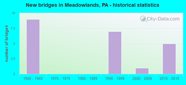
- New bridges - historical statistics
- 91960-1969
- 71990-1999
- 12000-2009
- 52010-2019
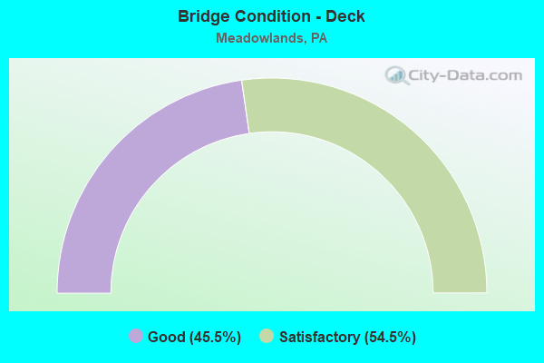
- Bridge Condition - Deck
- 45.5%Good
- 54.5%Satisfactory
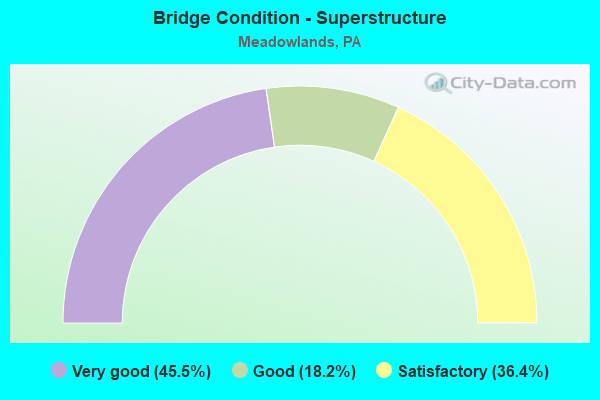
- Bridge Condition - Superstructure
- 45.5%Very good
- 18.2%Good
- 36.4%Satisfactory
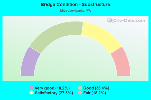
- Bridge Condition - Substructure
- 18.2%Very good
- 36.4%Good
- 27.3%Satisfactory
- 18.2%Fair
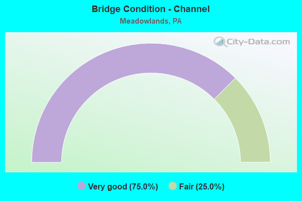
- Bridge Condition - Channel
- 75.0%Very good
- 25.0%Fair
Find on map >> Show street view
Structure Number: 34562, Location: SOUTH STRABANE TOWNSHIP (Lat: 40.210594, Lng: -80.238672), Route carried "on" structure: Interstate 79, Year Built: 1964, Year Reconstructed: 1990, Status: Open, Structure Length: 3.99m (13.09ft), Average Daily Traffic: 18,601 (year 2020), Truck Traffic: 18%, Average Future Daily Traffic: 10,024 (year 2032), Design Load: H 20, Features Intersected: SR 1045
Minimum Vertical Clearance: 30+ m (98+ ft), Kilometerpoint: 20.854, Lanes on structure: 2, Lanes under structure: 2, Base Highway Network: Yes, Owner: State Highway Agency, Approaching Roadway Width: 12.2m (40.0ft), Skew: 12 degrees, Material/Design: Steel continuous, Design/Construction: Stringer/Multi-beam, Number Of Spans In Main Unit: 3, Length of Maximum Span: 14.6m (47.9ft), Curb or Sidewalk Widths: Left: 0.2m (0.7ft), Right: 0.2m (0.7ft), Curb-To-Curb Width: 12.8m (42.0ft), Out-to-Out Width: 13.9m (45.6ft)
Condition: Deck: Satisfactory, Superstructure: Good, Substructure: Fair, Operating Rating: 89.8 metric tons, Method Used To Determine Operating Rating: Load Factor (LF), Inventory Rating: 67.1 metric tons, Method Used To Determine Inventory Rating: Load Factor (LF), Structural Evaluation: Somewhat better than minimum adequacy, Deck Geometry: Equal to present desirable criteria, Underclear: Somewhat better than minimum adequacy, Approach Roadway Alignment: Equal to present desirable criteria, Length Of Structure Improvement: 4.80m (15.75ft), Designated Inspection Frequency: Every 24 months, Inspection Date: September 2021, Deck Structure Type: Concrete Cast-file-Place, Wearing Surface/Protective System: Wearing Surface: Monolithic Concrete, Deck Protection: Epoxy Coated Reinforcing
Find on map >> Show street view
Structure Number: 34563, Location: SOUTH STRABANE TOWNSHIP (Lat: 40.210803, Lng: -80.238889), Route carried "on" structure: Interstate 79, Year Built: 1964, Year Reconstructed: 1990, Status: Open, Structure Length: 3.99m (13.09ft), Average Daily Traffic: 18,683 (year 2020), Truck Traffic: 20%, Average Future Daily Traffic: 9,226 (year 2032), Design Load: HS 20+Mod, Features Intersected: SR 1045
Minimum Vertical Clearance: 30+ m (98+ ft), Kilometerpoint: 21.676, Lanes on structure: 2, Lanes under structure: 2, Base Highway Network: Yes, Owner: State Highway Agency, Approaching Roadway Width: 12.2m (40.0ft), Skew: 12 degrees, Material/Design: Steel continuous, Design/Construction: Stringer/Multi-beam, Number Of Spans In Main Unit: 3, Length of Maximum Span: 14.6m (47.9ft), Curb or Sidewalk Widths: Left: 0.2m (0.7ft), Right: 0.2m (0.7ft), Curb-To-Curb Width: 12.8m (42.0ft), Out-to-Out Width: 13.9m (45.6ft)
Condition: Deck: Satisfactory, Superstructure: Satisfactory, Substructure: Fair, Operating Rating: 89.8 metric tons, Method Used To Determine Operating Rating: Load Factor (LF), Inventory Rating: 67.1 metric tons, Method Used To Determine Inventory Rating: Load Factor (LF), Structural Evaluation: Somewhat better than minimum adequacy, Deck Geometry: Equal to present desirable criteria, Underclear: Superior to present desirable criteria, Approach Roadway Alignment: Equal to present desirable criteria, Length Of Structure Improvement: 4.10m (13.45ft), Designated Inspection Frequency: Every 24 months, Inspection Date: September 2021, Bridge Improvement Cost: $45,000, Roadway Improvement Cost: $200,000, Total Project Cost: $605,000, Deck Structure Type: Concrete Cast-file-Place, Wearing Surface/Protective System: Wearing Surface: Monolithic Concrete, Deck Protection: Epoxy Coated Reinforcing
Find on map >> Show street view
Structure Number: 34564, Location: SOUTH STRABANE TWP (Lat: 40.210700, Lng: -80.228839), Route carried "on" structure: Interstate 79, Year Built: 1964, Year Reconstructed: 1990, Status: Open, Structure Length: 5.55m (18.21ft), Average Daily Traffic: 27,676 (year 2021), Truck Traffic: 11%, Average Future Daily Traffic: 10,024 (year 2032), Design Load: H 20, Features Intersected: SR 1009
Minimum Vertical Clearance: 30+ m (98+ ft), Kilometerpoint: 21.808, Lanes on structure: 2, Lanes under structure: 2, Base Highway Network: Yes, Owner: State Highway Agency, Approaching Roadway Width: 9.8m (32.2ft), Skew: 14 degrees, Material/Design: Steel continuous, Design/Construction: Stringer/Multi-beam, Number Of Spans In Main Unit: 3, Length of Maximum Span: 21.9m (71.9ft), Curb or Sidewalk Widths: Left: 0.2m (0.7ft), Right: 0.2m (0.7ft), Curb-To-Curb Width: 9.8m (32.2ft), Out-to-Out Width: 11.4m (37.4ft)
Condition: Deck: Satisfactory, Superstructure: Satisfactory, Substructure: Satisfactory, Operating Rating: 89.8 metric tons, Method Used To Determine Operating Rating: Load Factor (LF), Inventory Rating: 55.3 metric tons, Method Used To Determine Inventory Rating: Load Factor (LF), Structural Evaluation: Equal to present minimum criteria, Deck Geometry: High priority of replacement, Underclear: Better than present minimum criteria, Approach Roadway Alignment: Equal to present desirable criteria, Length Of Structure Improvement: 5.80m (19.03ft), Designated Inspection Frequency: Every 24 months, Inspection Date: September 2021, Bridge Improvement Cost: $55,000, Roadway Improvement Cost: $200,000, Total Project Cost: $739,000, Deck Structure Type: Concrete Cast-file-Place, Wearing Surface/Protective System: Wearing Surface: Monolithic Concrete, Deck Protection: Epoxy Coated Reinforcing
Find on map >> Show street view
Structure Number: 34565, Location: CHARTIERS & S. STRABANE (Lat: 40.210914, Lng: -80.228475), Route carried "on" structure: Interstate 79, Year Built: 1964, Year Reconstructed: 1990, Status: Open, Structure Length: 5.55m (18.21ft), Average Daily Traffic: 28,020 (year 2021), Truck Traffic: 11%, Average Future Daily Traffic: 9,226 (year 2032), Design Load: HS 20+Mod, Features Intersected: SR 1009
Minimum Vertical Clearance: 30.45m (99.90ft), Kilometerpoint: 22.590, Lanes on structure: 2, Lanes under structure: 2, Base Highway Network: Yes, Owner: State Highway Agency, Approaching Roadway Width: 9.8m (32.2ft), Skew: 14 degrees, Material/Design: Steel continuous, Design/Construction: Stringer/Multi-beam, Number Of Spans In Main Unit: 3, Length of Maximum Span: 21.9m (71.9ft), Curb or Sidewalk Widths: Left: 0.2m (0.7ft), Right: 0.2m (0.7ft), Curb-To-Curb Width: 10.5m (34.4ft), Out-to-Out Width: 11.6m (38.1ft)
Condition: Deck: Good, Superstructure: Satisfactory, Substructure: Satisfactory, Operating Rating: 89.8 metric tons, Method Used To Determine Operating Rating: Load Factor (LF), Inventory Rating: 53.5 metric tons, Method Used To Determine Inventory Rating: Load Factor (LF), Structural Evaluation: Equal to present minimum criteria, Deck Geometry: Meets minimum limits, Underclear: Superior to present desirable criteria, Approach Roadway Alignment: Equal to present desirable criteria, Length Of Structure Improvement: 5.80m (19.03ft), Designated Inspection Frequency: Every 24 months, Inspection Date: September 2021, Bridge Improvement Cost: $40,000, Roadway Improvement Cost: $200,000, Total Project Cost: $535,000, Deck Structure Type: Concrete Cast-file-Place, Wearing Surface/Protective System: Wearing Surface: Monolithic Concrete, Deck Protection: Epoxy Coated Reinforcing
Find on map >> Show street view
Structure Number: 3484, Location: S. STRABANE & N. STRABANE (Lat: 40.223100, Lng: -80.216875), Route carried "on" structure: State highway , Year Built: 1968, Status: Open, Structure Length: 1.01m (3.31ft), Average Daily Traffic: 10,477 (year 2021), Truck Traffic: 8%, Average Future Daily Traffic: 15,225 (year 2032), Design Load: HS 20, Features Intersected: BRANCH OF CHARTIERS CK., Facility Carried by Structure: SR 1041
Minimum Vertical Clearance: 30+ m (98+ ft), Kilometerpoint: 2.108, Lanes on structure: 2, Owner: State Highway Agency, Approaching Roadway Width: 12.2m (40.0ft), Skew: 4 degrees, Material/Design: Concrete, Design/Construction: Slab, Number Of Spans In Main Unit: 1, Length of Maximum Span: 9.1m (29.9ft), Curb or Sidewalk Widths: Left: 0.5m (1.6ft), Right: 0.5m (1.6ft), Curb-To-Curb Width: 12.2m (40.0ft), Out-to-Out Width: 13.9m (45.6ft)
Condition: Deck: Satisfactory, Superstructure: Satisfactory, Substructure: Good, Channel: Fair, Operating Rating: 74.4 metric tons, Method Used To Determine Operating Rating: Load Factor (LF), Inventory Rating: 44.5 metric tons, Method Used To Determine Inventory Rating: Load Factor (LF), Structural Evaluation: Equal to present minimum criteria, Deck Geometry: Somewhat better than minimum adequacy, Waterway Adequacy: Somewhat better than minimum adequacy, Approach Roadway Alignment: Equal to present desirable criteria, Length Of Structure Improvement: 1.60m (5.25ft), Designated Inspection Frequency: Every 24 months, Inspection Date: April 2020, Wearing Surface/Protective System: Wearing Surface: Bituminous
Find on map >> Show street view
Structure Number: 40342, Location: S. TRABENE & CHARTIERS TW (Lat: 40.211303, Lng: -80.239436), Route carried "on" structure: State highway , Year Built: 1998, Status: Open, Structure Length: 1.52m (4.99ft), Average Daily Traffic: 3,097 (year 2022), Truck Traffic: 1%, Average Future Daily Traffic: 3,115 (year 2032), Design Load: HS 25 or greater, Features Intersected: CHARTIERS CREEK, Facility Carried by Structure: SR 1045
Minimum Vertical Clearance: 30+ m (98+ ft), Kilometerpoint: 3.376, Lanes on structure: 2, Owner: State Highway Agency, Approaching Roadway Width: 9.8m (32.2ft), Material/Design: Prestressed concrete, Design/Construction: Box Beam or Girders - Multiple, Number Of Spans In Main Unit: 1, Length of Maximum Span: 15.2m (49.9ft), Curb or Sidewalk Widths: Left: 0.2m (0.7ft), Right: 0.2m (0.7ft), Curb-To-Curb Width: 10.0m (32.8ft), Out-to-Out Width: 11.1m (36.4ft)
Condition: Deck: Good, Superstructure: Good, Substructure: Good, Channel: Very good, Operating Rating: 89.8 metric tons, Method Used To Determine Operating Rating: Load Factor (LF), Inventory Rating: 40.8 metric tons, Method Used To Determine Inventory Rating: Load Factor (LF), Structural Evaluation: Better than present minimum criteria, Deck Geometry: Meets minimum limits, Waterway Adequacy: Superior to present desirable criteria, Approach Roadway Alignment: Equal to present desirable criteria, Length Of Structure Improvement: 2.20m (7.22ft), Designated Inspection Frequency: Every 48 months, Inspection Date: April 2020, Deck Structure Type: Concrete Cast-file-Place, Wearing Surface/Protective System: Wearing Surface: Monolithic Concrete, Deck Protection: Epoxy Coated Reinforcing
Find on map >> Show street view
Structure Number: 40697, Location: SOUTH STRABANE TOWNSHIP (Lat: 40.222681, Lng: -80.213219), Route carried "on" structure: Interstate 79, Year Built: 1999, Status: Open, Structure Length: 4.21m (13.81ft), Average Daily Traffic: 29,204 (year 2021), Truck Traffic: 11%, Average Future Daily Traffic: 10,296 (year 2032), Design Load: HS 20+Mod, Features Intersected: SR 1041
Minimum Vertical Clearance: 30+ m (98+ ft), Kilometerpoint: 23.226, Lanes on structure: 2, Lanes under structure: 4, Base Highway Network: Yes, Owner: State Highway Agency, Approaching Roadway Width: 11.9m (39.0ft), Skew: 12 degrees, Material/Design: Prestressed concrete, Design/Construction: Stringer/Multi-beam, Number Of Spans In Main Unit: 1, Length of Maximum Span: 40.5m (132.9ft), Curb or Sidewalk Widths: Left: 0.2m (0.7ft), Right: 0.2m (0.7ft), Curb-To-Curb Width: 12.0m (39.4ft), Out-to-Out Width: 12.9m (42.3ft)
Condition: Deck: Satisfactory, Superstructure: Very good, Substructure: Satisfactory, Inventory Rating: 33.6 metric tons, Method Used To Determine Inventory Rating: Load Factor (LF), Structural Evaluation: Equal to present minimum criteria, Deck Geometry: Equal to present minimum criteria, Underclear: Superior to present desirable criteria, Approach Roadway Alignment: Equal to present desirable criteria, Length Of Structure Improvement: 5.10m (16.73ft), Designated Inspection Frequency: Every 24 months, Inspection Date: September 2021, Deck Structure Type: Concrete Cast-file-Place, Wearing Surface/Protective System: Wearing Surface: Monolithic Concrete, Deck Protection: Epoxy Coated Reinforcing
Find on map >> Show street view
Structure Number: 40698, Location: SOUTH STRABANE TOWNSHIP (Lat: 40.222636, Lng: -80.213536), Route carried "on" structure: Interstate 79, Year Built: 1999, Status: Open, Structure Length: 4.21m (13.81ft), Average Daily Traffic: 30,396 (year 2021), Truck Traffic: 11%, Average Future Daily Traffic: 9,856 (year 2032), Design Load: HS 20+Mod, Features Intersected: SR 1041
Minimum Vertical Clearance: 30+ m (98+ ft), Kilometerpoint: 24.034, Lanes on structure: 2, Lanes under structure: 8, Base Highway Network: Yes, Owner: State Highway Agency, Approaching Roadway Width: 11.9m (39.0ft), Skew: 12 degrees, Material/Design: Prestressed concrete, Design/Construction: Stringer/Multi-beam, Number Of Spans In Main Unit: 1, Length of Maximum Span: 40.5m (132.9ft), Curb or Sidewalk Widths: Left: 0.2m (0.7ft), Right: 0.2m (0.7ft), Curb-To-Curb Width: 12.0m (39.4ft), Out-to-Out Width: 12.9m (42.3ft)
Condition: Deck: Satisfactory, Superstructure: Very good, Substructure: Good, Inventory Rating: 36.3 metric tons, Method Used To Determine Inventory Rating: Load Factor (LF), Structural Evaluation: Better than present minimum criteria, Deck Geometry: Equal to present minimum criteria, Underclear: Superior to present desirable criteria, Approach Roadway Alignment: Equal to present desirable criteria, Length Of Structure Improvement: 5.10m (16.73ft), Designated Inspection Frequency: Every 24 months, Inspection Date: September 2021, Deck Structure Type: Concrete Cast-file-Place, Wearing Surface/Protective System: Wearing Surface: Monolithic Concrete, Deck Protection: Epoxy Coated Reinforcing
Find on map >> Show street view
Structure Number: 45863, Location: 0.03 mi N of SR 0079(S) (Lat: 40.222678, Lng: -80.214900), Route carried "on" structure: State highway , Year Built: 2009, Status: Open, Structure Length: 2.65m (8.69ft), Average Daily Traffic: 10,477 (year 2021), Truck Traffic: 8%, Average Future Daily Traffic: 15,225 (year 2032), Design Load: HL 93, Features Intersected: Chartiers Creek, Facility Carried by Structure: SR 1041
Minimum Vertical Clearance: 30+ m (98+ ft), Kilometerpoint: 2.108, Lanes on structure: 3, Owner: State Highway Agency, Approaching Roadway Width: 11.0m (36.1ft), Material/Design: Prestressed concrete, Design/Construction: Box Beam or Girders - Multiple, Number Of Spans In Main Unit: 1, Length of Maximum Span: 25.9m (85.0ft), Curb or Sidewalk Widths: Left: 0.1m (0.3ft), Right: 0.1m (0.3ft), Curb-To-Curb Width: 12.8m (42.0ft), Out-to-Out Width: 14.1m (46.3ft)
Condition: Deck: Good, Superstructure: Very good, Substructure: Good, Channel: Very good, Operating Rating: 88.0 metric tons, Method Used To Determine Operating Rating: Load and Resistance Factor (LRFR), Inventory Rating: 49.9 metric tons, Method Used To Determine Inventory Rating: Load and Resistance Factor (LRFR), Structural Evaluation: Better than present minimum criteria, Deck Geometry: Meets minimum limits, Waterway Adequacy: Superior to present desirable criteria, Approach Roadway Alignment: Equal to present desirable criteria, Designated Inspection Frequency: Every 24 months, Inspection Date: April 2020, Deck Structure Type: Concrete Cast-file-Place, Wearing Surface/Protective System: Wearing Surface: Monolithic Concrete, Deck Protection: Epoxy Coated Reinforcing
Find on map >> Show street view
Structure Number: 47988, Location: 1.5 mi N from SR 0019 (Lat: 40.209517, Lng: -80.224983), Route carried "on" structure: State highway , Year Built: 2013, Status: Open, Structure Length: 0.61m (2.00ft), Average Daily Traffic: 5,339 (year 2022), Truck Traffic: 2%, Average Future Daily Traffic: 5,648 (year 2032), Design Load: HL 93, Features Intersected: Branch of Chartiers Ck., Facility Carried by Structure: SR 1047
Minimum Vertical Clearance: 30+ m (98+ ft), Kilometerpoint: 2.346, Lanes on structure: 3, Owner: State Highway Agency, Approaching Roadway Width: 7.3m (24.0ft), Material/Design: Concrete, Design/Construction: Culvert, Number Of Spans In Main Unit: 1, Length of Maximum Span: 6.1m (20.0ft)
Condition: Channel: Very good, Culverts: Good, Operating Rating: 59.3 metric tons, Method Used To Determine Operating Rating: Assigned ratings based on Load and Resistance Factor Design (LRFD) reported by rating factor (RF) using HL93 loadings, Inventory Rating: 37.3 metric tons, Method Used To Determine Inventory Rating: Assigned ratings based on Load and Resistance Factor Design (LRFD) reported by rating factor (RF) using HL93 loadings, Structural Evaluation: Better than present minimum criteria, Waterway Adequacy: Better than present minimum criteria, Approach Roadway Alignment: Equal to present desirable criteria, Designated Inspection Frequency: Every 48 months, Inspection Date: April 2020
Find on map >> Show street view
Structure Number: 49152, Location: 2.4 mi N of 79N/70W (Lat: 40.210836, Lng: -80.225608), Route carried "on" structure: Interstate 79, Year Built: 2014, Status: Open, Structure Length: 2.56m (8.40ft), Average Daily Traffic: 27,676 (year 2021), Truck Traffic: 11%, Average Future Daily Traffic: 35,700 (year 2036), Design Load: HL 93, Features Intersected: SR 1047 (Manifold Road)
Minimum Vertical Clearance: 30+ m (98+ ft), Kilometerpoint: 21.808, Lanes on structure: 2, Lanes under structure: 4, Base Highway Network: Yes, Owner: State Highway Agency, Approaching Roadway Width: 18.3m (60.0ft), Material/Design: Prestressed concrete, Design/Construction: Box Beam or Girders - Single/Spread, Number Of Spans In Main Unit: 1, Length of Maximum Span: 25.0m (82.0ft), Curb or Sidewalk Widths: Left: 0.1m (0.3ft), Right: 0.1m (0.3ft), Curb-To-Curb Width: 18.3m (60.0ft), Out-to-Out Width: 19.3m (63.3ft)
Condition: Deck: Good, Superstructure: Very good, Substructure: Very good, Operating Rating: 71.6 metric tons, Method Used To Determine Operating Rating: Assigned ratings based on Load and Resistance Factor Design (LRFD) reported by rating factor (RF) using HL93 loadings, Inventory Rating: 44.1 metric tons, Method Used To Determine Inventory Rating: Assigned ratings based on Load and Resistance Factor Design (LRFD) reported by rating factor (RF) using HL93 loadings, Structural Evaluation: Equal to present desirable criteria, Deck Geometry: Superior to present desirable criteria, Underclear: Superior to present desirable criteria, Approach Roadway Alignment: Equal to present desirable criteria, Designated Inspection Frequency: Every 48 months, Inspection Date: September 2021, Deck Structure Type: Concrete Cast-file-Place, Wearing Surface/Protective System: Wearing Surface: Monolithic Concrete, Deck Protection: Epoxy Coated Reinforcing
Find on map >> Show street view
Structure Number: 52397, Location: 2.4 mi N of 79N/70W (Lat: 40.211119, Lng: -80.225539), Route carried "on" structure: Interstate 79, Year Built: 2014, Status: Open, Structure Length: 2.56m (8.40ft), Average Daily Traffic: 28,020 (year 2021), Truck Traffic: 11%, Average Future Daily Traffic: 40,565 (year 2038), Design Load: HL 93, Features Intersected: SR 1047 (Manifold Road)
Minimum Vertical Clearance: 30+ m (98+ ft), Kilometerpoint: 22.590, Lanes on structure: 2, Lanes under structure: 4, Base Highway Network: Yes, Owner: State Highway Agency, Approaching Roadway Width: 12.8m (42.0ft), Material/Design: Prestressed concrete, Design/Construction: Box Beam or Girders - Single/Spread, Number Of Spans In Main Unit: 1, Length of Maximum Span: 25.0m (82.0ft), Curb or Sidewalk Widths: Left: 0.1m (0.3ft), Right: 0.1m (0.3ft), Curb-To-Curb Width: 12.8m (42.0ft), Out-to-Out Width: 13.8m (45.3ft)
Condition: Deck: Good, Superstructure: Very good, Substructure: Very good, Operating Rating: 78.1 metric tons, Method Used To Determine Operating Rating: Assigned ratings based on Load and Resistance Factor Design (LRFD) reported by rating factor (RF) using HL93 loadings, Inventory Rating: 49.2 metric tons, Method Used To Determine Inventory Rating: Assigned ratings based on Load and Resistance Factor Design (LRFD) reported by rating factor (RF) using HL93 loadings, Structural Evaluation: Equal to present desirable criteria, Deck Geometry: Equal to present desirable criteria, Underclear: Superior to present desirable criteria, Approach Roadway Alignment: Equal to present desirable criteria, Designated Inspection Frequency: Every 48 months, Inspection Date: September 2021, Deck Structure Type: Concrete Cast-file-Place, Wearing Surface/Protective System: Wearing Surface: Monolithic Concrete, Deck Protection: Epoxy Coated Reinforcing
Find on map >> Show street view
Structure Number: 34562, Location: SOUTH STRABANE TOWNSHIP (Lat: 40.210594, Lng: -80.238672), Route carried "under" structure: State highway , Year Built: 1964, Structure Length: 0. m, Average Daily Traffic: 3,097 (year 2022), Truck Traffic: 1%, Features Intersected: SR 1045, Facility Carried by Structure: SR 0079
Minimum Vertical Clearance: 4.50m (14.76ft), Kilometerpoint: 3.376, Lanes on structure: 2, Lanes under structure: 2, Material/Design: Steel continuous, Design/Construction: Stringer/Multi-beam, Length of Maximum Span: 14.6m (47.9ft)
Find on map >> Show street view
Structure Number: 34563, Location: SOUTH STRABANE TOWNSHIP (Lat: 40.210803, Lng: -80.238889), Route carried "under" structure: State highway , Year Built: 1964, Structure Length: 0. m, Average Daily Traffic: 3,097 (year 2022), Truck Traffic: 1%, Features Intersected: SR 1045, Facility Carried by Structure: SR 0079
Minimum Vertical Clearance: 5.43m (17.81ft), Kilometerpoint: 3.376, Lanes on structure: 2, Lanes under structure: 2, Material/Design: Steel continuous, Design/Construction: Stringer/Multi-beam, Length of Maximum Span: 14.6m (47.9ft)
Find on map >> Show street view
Structure Number: 34564, Location: SOUTH STRABANE TWP (Lat: 40.210700, Lng: -80.228839), Route carried "under" structure: State highway , Year Built: 1964, Structure Length: 0. m, Average Daily Traffic: 7,493 (year 2021), Truck Traffic: 8%, Features Intersected: SR 1009, Facility Carried by Structure: SR 0079
Minimum Vertical Clearance: 4.98m (16.34ft), Kilometerpoint: 3.312, Lanes on structure: 2, Lanes under structure: 2, Material/Design: Steel continuous, Design/Construction: Stringer/Multi-beam, Length of Maximum Span: 21.9m (71.9ft)
Find on map >> Show street view
Structure Number: 34565, Location: CHARTIERS & S. STRABANE (Lat: 40.210914, Lng: -80.228475), Route carried "under" structure: State highway , Year Built: 1964, Structure Length: 0. m, Average Daily Traffic: 7,493 (year 2021), Truck Traffic: 8%, Features Intersected: SR 1009, Facility Carried by Structure: SR 0079
Minimum Vertical Clearance: 6.12m (20.08ft), Kilometerpoint: 3.312, Lanes on structure: 2, Lanes under structure: 2, Material/Design: Steel continuous, Design/Construction: Stringer/Multi-beam, Length of Maximum Span: 21.9m (71.9ft)
Find on map >> Show street view
Structure Number: 40697, Location: SOUTH STRABANE TOWNSHIP (Lat: 40.222681, Lng: -80.213219), Route carried "under" structure: State highway , Year Built: 1999, Structure Length: 0. m, Average Daily Traffic: 5,239 (year 2021), Truck Traffic: 8%, Features Intersected: SR 1041, Facility Carried by Structure: SR0079
Minimum Vertical Clearance: 5.31m (17.42ft), Kilometerpoint: 1.402, Lanes on structure: 2, Lanes under structure: 4, Material/Design: Prestressed concrete, Design/Construction: Stringer/Multi-beam, Length of Maximum Span: 40.5m (132.9ft)
Find on map >> Show street view
Structure Number: 40697, Location: SOUTH STRABANE TOWNSHIP (Lat: 40.222681, Lng: -80.213219), Route carried "under" structure: State highway , Year Built: 1999, Structure Length: 0. m, Average Daily Traffic: 5,239 (year 2021), Truck Traffic: 8%, Features Intersected: SR 1041, Facility Carried by Structure: SR0079
Minimum Vertical Clearance: 5.31m (17.42ft), Kilometerpoint: 1.410, Lanes on structure: 2, Lanes under structure: 4, Material/Design: Prestressed concrete, Design/Construction: Stringer/Multi-beam, Length of Maximum Span: 40.5m (132.9ft)
Find on map >> Show street view
Structure Number: 40698, Location: SOUTH STRABANE TOWNSHIP (Lat: 40.222636, Lng: -80.213536), Route carried "under" structure: State highway , Year Built: 1999, Structure Length: 0. m, Average Daily Traffic: 5,239 (year 2021), Truck Traffic: 8%, Features Intersected: SR 1041, Facility Carried by Structure: SR 0079
Minimum Vertical Clearance: 5.36m (17.59ft), Kilometerpoint: 1.402, Lanes on structure: 2, Lanes under structure: 4, Material/Design: Prestressed concrete, Design/Construction: Stringer/Multi-beam, Length of Maximum Span: 40.5m (132.9ft)
Find on map >> Show street view
Structure Number: 40698, Location: SOUTH STRABANE TOWNSHIP (Lat: 40.222636, Lng: -80.213536), Route carried "under" structure: State highway , Year Built: 1999, Structure Length: 0. m, Average Daily Traffic: 5,239 (year 2021), Truck Traffic: 8%, Features Intersected: SR 1041, Facility Carried by Structure: SR 0079
Minimum Vertical Clearance: 5.39m (17.68ft), Kilometerpoint: 1.410, Lanes on structure: 2, Lanes under structure: 4, Material/Design: Prestressed concrete, Design/Construction: Stringer/Multi-beam, Length of Maximum Span: 40.5m (132.9ft)
Find on map >> Show street view
Structure Number: 49152, Location: 2.4 mi N of 79N/70W (Lat: 40.210836, Lng: -80.225608), Route carried "under" structure: State highway , Year Built: 2014, Structure Length: 0. m, Average Daily Traffic: 5,339 (year 2022), Truck Traffic: 2%, Features Intersected: SR 1047 (Manifold Road), Facility Carried by Structure: SR 0079 NB
Minimum Vertical Clearance: 5.12m (16.80ft), Kilometerpoint: 2.346, Lanes on structure: 2, Lanes under structure: 4, Material/Design: Prestressed concrete, Design/Construction: Box Beam or Girders - Single/Spread, Length of Maximum Span: 25.0m (82.0ft)
Find on map >> Show street view
Structure Number: 52397, Location: 2.4 mi N of 79N/70W (Lat: 40.211119, Lng: -80.225539), Route carried "under" structure: State highway , Year Built: 2014, Structure Length: 0. m, Average Daily Traffic: 5,339 (year 2022), Truck Traffic: 2%, Features Intersected: SR 1047 (Manifold Road), Facility Carried by Structure: SR 0079 SB
Minimum Vertical Clearance: 5.12m (16.80ft), Kilometerpoint: 2.346, Lanes on structure: 2, Lanes under structure: 4, Material/Design: Prestressed concrete, Design/Construction: Box Beam or Girders - Single/Spread, Length of Maximum Span: 25.0m (82.0ft)