Bridge Statistics for Melvindale, Michigan (MI)
Condition, Traffic, Stress, Structural Evaluation, Project Costs
- National Bridge Inventory (NBI) Statistics
- 12Number of bridges
- 72ft / 21.9mTotal length
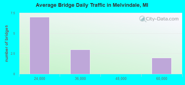
- 328,479Total average daily traffic
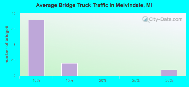
- 31,718Total average daily truck traffic
- National Bridge Inventory (NBI) Registered Bridges for Melvindale
- No street view available for this location
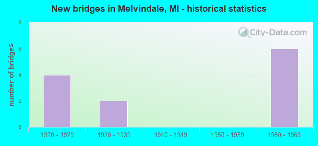
- New bridges - historical statistics
- 41920-1929
- 21930-1939
- 61960-1969
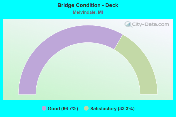
- Bridge Condition - Deck
- 66.7%Good
- 33.3%Satisfactory
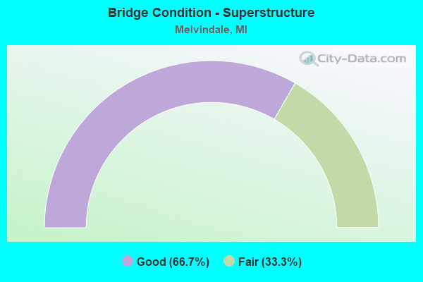
- Bridge Condition - Superstructure
- 66.7%Good
- 33.3%Fair
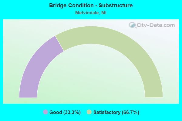
- Bridge Condition - Substructure
- 33.3%Good
- 66.7%Satisfactory
Find on map >> Show street view
Structure Number: 1222, Location: 2.3 MI N OF BRANCH COL (Lat: 42.100219, Lng: -84.996972), Route carried "on" structure: Interstate 69, Year Built: 1968, Year Reconstructed: 2003, Status: Open, Structure Length: 4.27m (14.01ft), Average Daily Traffic: 19,534 (year 2014), Truck Traffic: 26%, Average Future Daily Traffic: 22,464 (year 2034), Design Load: HS 20+Mod, Features Intersected: CONRAIL (ABN)
Minimum Vertical Clearance: 30.48m (100.00ft), Kilometerpoint: 3.555, Lanes on structure: 2, Base Highway Network: Yes (Inventory Route: 129, Subroute: 1), Owner: State Highway Agency, Approaching Roadway Width: 12.4m (40.7ft), Skew: 1 degrees, Material/Design: Steel, Design/Construction: Stringer/Multi-beam, Number Of Spans In Main Unit: 3, Length of Maximum Span: 15.8m (51.8ft), Curb-To-Curb Width: 16.8m (55.1ft), Out-to-Out Width: 17.8m (58.4ft)
Condition: Deck: Good, Superstructure: Fair, Substructure: Good, Operating Rating: 58.3 metric tons, Method Used To Determine Operating Rating: Load Factor (LF) rating reported by rating factor (RF) method using MS18 loading, Inventory Rating: 35.0 metric tons, Method Used To Determine Inventory Rating: Load Factor (LF) rating reported by rating factor (RF) method using MS18 loading, Structural Evaluation: Somewhat better than minimum adequacy, Deck Geometry: Superior to present desirable criteria, Approach Roadway Alignment: Equal to present desirable criteria, Designated Inspection Frequency: Every 24 months, Inspection Date: June 2021, Deck Structure Type: Concrete Cast-file-Place, Wearing Surface/Protective System: Wearing Surface: Monolithic Concrete, Deck Protection: Epoxy Coated Reinforcing
Find on map >> Show street view
Structure Number: 1173, Location: IN MELVINDALE (Lat: 42.264981, Lng: -83.170914), Route carried "on" structure: Interstate 75, Year Built: 1966, Year Reconstructed: 2002, Status: Open, Structure Length: 8.84m (29.00ft), Average Daily Traffic: 51,189 (year 2007), Truck Traffic: 12%, Average Future Daily Traffic: 49,610 (year 2018), Design Load: HS 25 or greater, Features Intersected: OUTER DRIVE
Minimum Vertical Clearance: 30.48m (100.00ft), Kilometerpoint: 24.276, Lanes on structure: 3, Lanes under structure: 8, Base Highway Network: Yes (Inventory Route: 159, Subroute: 10), Owner: State Highway Agency, Approaching Roadway Width: 18.2m (59.7ft), Skew: 14 degrees, Material/Design: Steel continuous, Design/Construction: Stringer/Multi-beam, Number Of Spans In Main Unit: 2, Number Of Approach Spans: 2, Length of Maximum Span: 30.3m (99.4ft), Curb-To-Curb Width: 17.4m (57.1ft), Out-to-Out Width: 18.4m (60.4ft)
Condition: Deck: Good, Superstructure: Good, Substructure: Satisfactory, Operating Rating: 63.2 metric tons, Method Used To Determine Operating Rating: Load Factor (LF) rating reported by rating factor (RF) method using MS18 loading, Inventory Rating: 37.6 metric tons, Method Used To Determine Inventory Rating: Load Factor (LF) rating reported by rating factor (RF) method using MS18 loading, Structural Evaluation: Equal to present minimum criteria, Deck Geometry: Better than present minimum criteria, Underclear: Somewhat better than minimum adequacy, Approach Roadway Alignment: Equal to present desirable criteria, Designated Inspection Frequency: Every 24 months, Inspection Date: June 2021, Deck Structure Type: Concrete Cast-file-Place, Wearing Surface/Protective System: Wearing Surface: Monolithic Concrete, Deck Protection: Epoxy Coated Reinforcing
Find on map >> Show street view
Structure Number: 11731, Location: IN MELVINDALE (Lat: 42.265042, Lng: -83.171303), Route carried "on" structure: Interstate 75, Year Built: 1966, Year Reconstructed: 2002, Status: Open, Structure Length: 8.84m (29.00ft), Average Daily Traffic: 51,189 (year 2007), Truck Traffic: 12%, Average Future Daily Traffic: 49,610 (year 2018), Design Load: HS 25 or greater, Features Intersected: OUTER DRIVE
Minimum Vertical Clearance: 30.48m (100.00ft), Kilometerpoint: 24.265, Lanes on structure: 3, Lanes under structure: 7, Base Highway Network: Yes (Inventory Route: 159, Subroute: 6), Owner: State Highway Agency, Approaching Roadway Width: 18.2m (59.7ft), Skew: 14 degrees, Material/Design: Steel continuous, Design/Construction: Stringer/Multi-beam, Number Of Spans In Main Unit: 2, Number Of Approach Spans: 2, Length of Maximum Span: 30.1m (98.8ft), Curb-To-Curb Width: 17.4m (57.1ft), Out-to-Out Width: 18.4m (60.4ft)
Condition: Deck: Satisfactory, Superstructure: Good, Substructure: Satisfactory, Operating Rating: 65.8 metric tons, Method Used To Determine Operating Rating: Load Factor (LF) rating reported by rating factor (RF) method using MS18 loading, Inventory Rating: 39.2 metric tons, Method Used To Determine Inventory Rating: Load Factor (LF) rating reported by rating factor (RF) method using MS18 loading, Structural Evaluation: Equal to present minimum criteria, Deck Geometry: Better than present minimum criteria, Underclear: Somewhat better than minimum adequacy, Approach Roadway Alignment: Equal to present desirable criteria, Designated Inspection Frequency: Every 24 months, Inspection Date: June 2021, Deck Structure Type: Concrete Cast-file-Place, Wearing Surface/Protective System: Wearing Surface: Monolithic Concrete, Deck Protection: Epoxy Coated Reinforcing
Find on map >> Show street view
Structure Number: 1173, Location: IN MELVINDALE (Lat: 42.264981, Lng: -83.170914), Route carried "under" structure: County highway 2057, Year Built: 1966, Structure Length: 0. m, Average Daily Traffic: 19,000 (year 1996), Truck Traffic: 8%, Features Intersected: OUTER DRIVE, Facility Carried by Structure: I-75 NB
Minimum Vertical Clearance: 4.98m (16.34ft), Kilometerpoint: 3.190, Lanes on structure: 3, Lanes under structure: 8, Material/Design: Steel continuous, Design/Construction: Stringer/Multi-beam, Length of Maximum Span: 30.3m (99.4ft)
Find on map >> Show street view
Structure Number: 11731, Location: IN MELVINDALE (Lat: 42.265042, Lng: -83.171303), Route carried "under" structure: County highway 2057, Year Built: 1966, Structure Length: 0. m, Average Daily Traffic: 19,000 (year 1996), Truck Traffic: 8%, Features Intersected: OUTER DRIVE, Facility Carried by Structure: I-75 SB
Minimum Vertical Clearance: 5.11m (16.77ft), Kilometerpoint: 3.224, Lanes on structure: 3, Lanes under structure: 7, Material/Design: Steel continuous, Design/Construction: Stringer/Multi-beam, Length of Maximum Span: 30.1m (98.8ft)
Find on map >> Show street view
Structure Number: 12218, Location: MLVNDAL/LINCOLN PK W/I-75 (Lat: 42.266514, Lng: -83.176394), Route carried "under" structure: County highway 2507, Year Built: 1932, Structure Length: 0. m, Average Daily Traffic: 26,100 (year 1996), Truck Traffic: 7%, Features Intersected: OUTER DRIVE (EB), Facility Carried by Structure: CONRAIL
Minimum Vertical Clearance: 4.47m (14.67ft), Kilometerpoint: 1.625, Lanes under structure: 3, Material/Design: Steel, Design/Construction: Girder and Floorbeam System, Length of Maximum Span: 11.2m (36.7ft)
Find on map >> Show street view
Structure Number: 12219, Location: MLVNDAL/LINCOLN PK W/I-75 (Lat: 42.266717, Lng: -83.176225), Route carried "under" structure: County highway 2507, Year Built: 1920, Structure Length: 0. m, Average Daily Traffic: 25,624 (year 1993), Truck Traffic: 7%, Features Intersected: OUTER DRIVE (WB), Facility Carried by Structure: CONRAIL
Minimum Vertical Clearance: 4.32m (14.17ft), Kilometerpoint: 3.673, Lanes under structure: 3, Material/Design: Steel, Design/Construction: Girder and Floorbeam System, Length of Maximum Span: 10.9m (35.8ft)
Find on map >> Show street view
Structure Number: 1222, Location: ALLEN PK & MLVINDL S/I-94 (Lat: 42.275319, Lng: -83.200750), Route carried "under" structure: Spur County highway , Year Built: 1931, Structure Length: 0. m, Average Daily Traffic: 24,077 (year 1993), Truck Traffic: 5%, Features Intersected: OUTER DRIVE, Facility Carried by Structure: GTW RR
Minimum Vertical Clearance: 4.47m (14.67ft), Kilometerpoint: 0.727, Lanes under structure: 6, Material/Design: Steel, Design/Construction: Girder and Floorbeam System, Length of Maximum Span: 15.5m (50.9ft)
Find on map >> Show street view
Structure Number: 12221, Location: MELVINDALE N/OUTER DRIVE (Lat: 42.278622, Lng: -83.173561), Route carried "under" structure: County highway 2057, Year Built: 1927, Structure Length: 0. m, Average Daily Traffic: 23,173 (year 1997), Truck Traffic: 7%, Features Intersected: TOLEDO ROAD, Facility Carried by Structure: NORFOLK SOUTHRN RR
Minimum Vertical Clearance: 4.26m (13.98ft), Kilometerpoint: 13.897, Lanes under structure: 4, Material/Design: Steel, Design/Construction: Stringer/Multi-beam, Length of Maximum Span: 21.3m (69.9ft)
Find on map >> Show street view
Structure Number: 12222, Location: MELVINDALE N/OUTER DRIVE (Lat: 42.278175, Lng: -83.173953), Route carried "under" structure: County highway 2057, Year Built: 1927, Structure Length: 0. m, Average Daily Traffic: 23,173 (year 1997), Truck Traffic: 7%, Features Intersected: TOLEDO ROAD, Facility Carried by Structure: NORFOLK SOUTHRN RR
Minimum Vertical Clearance: 4.14m (13.58ft), Kilometerpoint: 13.838, Lanes under structure: 4, Material/Design: Steel, Design/Construction: Stringer/Multi-beam, Length of Maximum Span: 21.3m (69.9ft)
Find on map >> Show street view
Structure Number: 12223, Location: MELVINDALE N/OUTER DRIVE (Lat: 42.277428, Lng: -83.174583), Route carried "under" structure: County highway 2057, Year Built: 1927, Structure Length: 0. m, Average Daily Traffic: 23,173 (year 1997), Truck Traffic: 7%, Features Intersected: TOLEDO ROAD, Facility Carried by Structure: NORFOLK SOUTHRN RR
Minimum Vertical Clearance: 4.19m (13.75ft), Kilometerpoint: 13.739, Lanes under structure: 4, Material/Design: Steel, Design/Construction: Girder and Floorbeam System, Length of Maximum Span: 21.3m (69.9ft)
Find on map >> Show street view
Structure Number: 12227, Location: DETROIT/MELVINDALE N/I-75 (Lat: 42.279531, Lng: -83.159017), Route carried "under" structure: County highway 2057, Year Built: 1961, Structure Length: 0. m, Average Daily Traffic: 23,247 (year 1994), Truck Traffic: 7%, Features Intersected: SCHAEFER ROAD, Facility Carried by Structure: MARATHON GAS LINE
Minimum Vertical Clearance: 4.75m (15.58ft), Kilometerpoint: 0.138, Lanes under structure: 4, Material/Design: Steel, Design/Construction: Girder and Floorbeam System, Length of Maximum Span: 37.8m (124.0ft)