Bridge Statistics for Middletown, Maryland (MD)
Condition, Traffic, Stress, Structural Evaluation, Project Costs
- National Bridge Inventory (NBI) Statistics
- 20Number of bridges
- 125ft / 37.9mTotal length
- $151,000Total costs
- 41,390Total average daily traffic
- 2,448Total average daily truck traffic
- 54,396Total future (year 2015) average daily traffic
- National Bridge Inventory (NBI) Registered Bridges for Middletown
- No street view available for this location
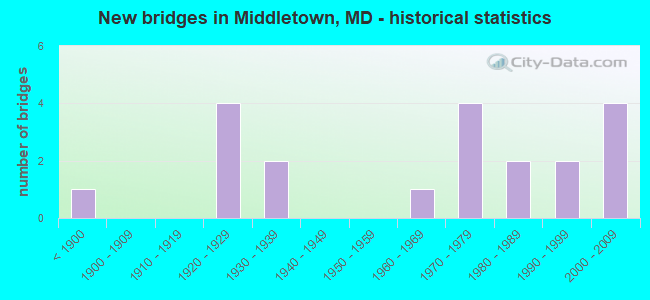
- New bridges - historical statistics
- 1Before 1900
- 41920-1929
- 21930-1939
- 11960-1969
- 41970-1979
- 21980-1989
- 21990-1999
- 42000-2009
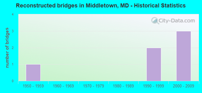
- Reconstructed bridges - Historical Statistics
- 11950-1959
- 01960-1969
- 01970-1979
- 01980-1989
- 21990-1999
- 32000-2009
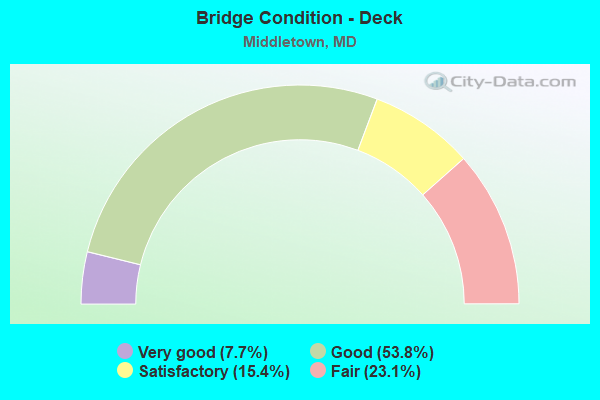
- Bridge Condition - Deck
- 7.7%Very good
- 53.8%Good
- 15.4%Satisfactory
- 23.1%Fair
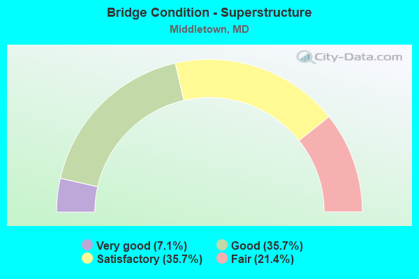
- Bridge Condition - Superstructure
- 7.1%Very good
- 35.7%Good
- 35.7%Satisfactory
- 21.4%Fair
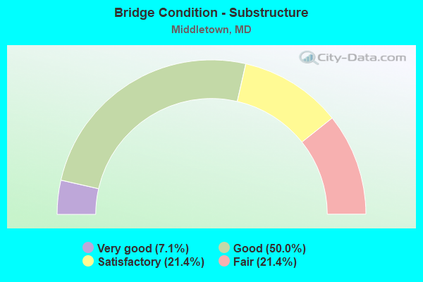
- Bridge Condition - Substructure
- 7.1%Very good
- 50.0%Good
- 21.4%Satisfactory
- 21.4%Fair
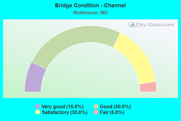
- Bridge Condition - Channel
- 15.0%Very good
- 50.0%Good
- 30.0%Satisfactory
- 5.0%Fair
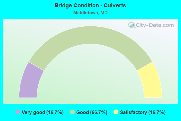
- Bridge Condition - Culverts
- 16.7%Very good
- 66.7%Good
- 16.7%Satisfactory
Find on map >> Show street view
Structure Number: 10000010001801, Location: 0.6 M S OF MAERK ROAD (Lat: 39.428278, Lng: -77.556000), Route carried "on" structure: State highway 17, Year Built: 1934, Status: Open, Structure Length: 4.45m (14.60ft), Average Daily Traffic: 5,450 (year 2017), Truck Traffic: 2%, Average Future Daily Traffic: 7,000 (year 2037), Design Load: H 20, Features Intersected: CATOCTIN CREEK
Minimum Vertical Clearance: 4.57m (14.99ft), Kilometerpoint: 18.697, Lanes on structure: 2, Owner: State Highway Agency, Approaching Roadway Width: 13.1m (43.0ft), Skew: 2 degrees, Material/Design: Steel, Design/Construction: Truss - Thru, Number Of Spans In Main Unit: 1, Length of Maximum Span: 42.7m (140.1ft), Curb-To-Curb Width: 9.1m (29.9ft), Out-to-Out Width: 9.6m (31.5ft)
Condition: Deck: Fair, Superstructure: Fair, Substructure: Satisfactory, Channel: Good, Operating Rating: 63.5 metric tons, Method Used To Determine Operating Rating: Load Factor (LF), Inventory Rating: 37.6 metric tons, Method Used To Determine Inventory Rating: Load Factor (LF), Structural Evaluation: Somewhat better than minimum adequacy, Deck Geometry: High priority of corrective action, Waterway Adequacy: Superior to present desirable criteria, Approach Roadway Alignment: Equal to present desirable criteria, Designated Inspection Frequency: Every 24 months, Critical Feature Inspection Frequency: Every 24 months, Inspection Date: May 2020, Critical Feature Inspection Date: May 2020, Deck Structure Type: Concrete Cast-file-Place, Wearing Surface/Protective System: Wearing Surface: Bituminous
Find on map >> Show street view
Structure Number: 10000010001901, Location: 1.13 MILES N OF MD 383 (Lat: 39.419967, Lng: -77.571489), Route carried "on" structure: State highway 17, Year Built: 1923, Year Reconstructed: 1958, Status: Open, Structure Length: 1.68m (5.51ft), Average Daily Traffic: 5,891 (year 2009), Truck Traffic: 8%, Average Future Daily Traffic: 7,738 (year 2026), Design Load: HS 20, Features Intersected: MIDDLE CREEK
Minimum Vertical Clearance: 30+ m (98+ ft), Kilometerpoint: 17.055, Lanes on structure: 2, Owner: State Highway Agency, Approaching Roadway Width: 13.4m (44.0ft), Material/Design: Concrete, Design/Construction: Tee Beam, Number Of Spans In Main Unit: 2, Length of Maximum Span: 8.2m (26.9ft), Curb-To-Curb Width: 14.4m (47.2ft), Out-to-Out Width: 15.0m (49.2ft)
Condition: Deck: Fair, Superstructure: Fair, Substructure: Fair, Channel: Fair, Operating Rating: 34.9 metric tons, Method Used To Determine Operating Rating: Load Factor (LF), Inventory Rating: 20.9 metric tons, Method Used To Determine Inventory Rating: Load Factor (LF), Structural Evaluation: Somewhat better than minimum adequacy, Deck Geometry: Superior to present desirable criteria, Waterway Adequacy: Better than present minimum criteria, Approach Roadway Alignment: Equal to present desirable criteria, Designated Inspection Frequency: Every 12 months, Inspection Date: November 2021, Deck Structure Type: Concrete Cast-file-Place, Wearing Surface/Protective System: Wearing Surface: Bituminous
Find on map >> Show street view
Structure Number: 10000010003301, Location: 0.29 MI E OF HOLLOW ROAD (Lat: 39.475211, Lng: -77.518697), Route carried "on" structure: US 40, Year Built: 1936, Status: Open, Structure Length: 1.07m (3.51ft), Average Daily Traffic: 5,522 (year 2009), Truck Traffic: 8%, Average Future Daily Traffic: 8,702 (year 2029), Features Intersected: TRIB TO HAWBOTTOM BRANCH
Minimum Vertical Clearance: 30+ m (98+ ft), Kilometerpoint: 10.241, Lanes on structure: 2, Owner: State Highway Agency, Approaching Roadway Width: 12.2m (40.0ft), Skew: 3 degrees, Material/Design: Concrete, Design/Construction: Tee Beam, Number Of Spans In Main Unit: 1, Length of Maximum Span: 9.1m (29.9ft), Curb-To-Curb Width: 12.2m (40.0ft), Out-to-Out Width: 13.4m (44.0ft)
Condition: Deck: Satisfactory, Superstructure: Satisfactory, Substructure: Fair, Channel: Satisfactory, Operating Rating: 60.3 metric tons, Method Used To Determine Operating Rating: Load Factor (LF), Inventory Rating: 36.3 metric tons, Method Used To Determine Inventory Rating: Load Factor (LF), Structural Evaluation: Somewhat better than minimum adequacy, Deck Geometry: Somewhat better than minimum adequacy, Waterway Adequacy: Better than present minimum criteria, Approach Roadway Alignment: Equal to present desirable criteria, Designated Inspection Frequency: Every 24 months, Inspection Date: July 2021, Deck Structure Type: Concrete Cast-file-Place, Wearing Surface/Protective System: Wearing Surface: Bituminous
Find on map >> Show street view
Structure Number: 10000010004001, Location: 0.05 M E OF MARKER ROAD (Lat: 39.450292, Lng: -77.562711), Route carried "on" structure: Alternate US 40, Year Built: 1923, Status: Open, Structure Length: 2.59m (8.50ft), Average Daily Traffic: 9,212 (year 2009), Truck Traffic: 8%, Average Future Daily Traffic: 11,013 (year 2026), Features Intersected: CATOCTIN CREEK
Minimum Vertical Clearance: 30+ m (98+ ft), Kilometerpoint: 6.516, Lanes on structure: 2, Base Highway Network: Yes, Owner: State Highway Agency, Approaching Roadway Width: 9.1m (29.9ft), Material/Design: Concrete, Design/Construction: Arch - Deck, Number Of Spans In Main Unit: 1, Length of Maximum Span: 25.9m (85.0ft), Curb-To-Curb Width: 7.3m (24.0ft), Out-to-Out Width: 8.2m (26.9ft)
Condition: Deck: Satisfactory, Superstructure: Satisfactory, Substructure: Satisfactory, Channel: Good, Operating Rating: 34.5 metric tons, Method Used To Determine Operating Rating: Load Factor (LF), Inventory Rating: 20.9 metric tons, Method Used To Determine Inventory Rating: Load Factor (LF), Structural Evaluation: Somewhat better than minimum adequacy, Deck Geometry: High priority of replacement, Waterway Adequacy: Better than present minimum criteria, Approach Roadway Alignment: Equal to present desirable criteria, Length Of Structure Improvement: 2.59m (8.50ft), Designated Inspection Frequency: Every 24 months, Underwater Inspection Frequency: Every 48 months, Inspection Date: August 2020, Underwater Inspection Date: August 2018, Bridge Improvement Cost: $137,000, Roadway Improvement Cost: $14,000, Total Project Cost: $151,000, Deck Structure Type: Concrete Cast-file-Place, Wearing Surface/Protective System: Wearing Surface: Bituminous
Find on map >> Show street view
Structure Number: 200000F-030101, Location: 0.25 MI N OF ALT. 40 (Lat: 39.453786, Lng: -77.560103), Route carried "on" structure: County highway 245, Year Built: 1994, Status: Open, Structure Length: 2.59m (8.50ft), Average Daily Traffic: 938 (year 2009), Truck Traffic: 5%, Average Future Daily Traffic: 1,126 (year 2032), Design Load: HS 25 or greater, Features Intersected: LITTLE CATOCTIN CREEK, Facility Carried by Structure: OLD HAGERSTOWN RD
Minimum Vertical Clearance: 30+ m (98+ ft), Kilometerpoint: 4.023, Lanes on structure: 2, Owner: County Highway Agency, Approaching Roadway Width: 10.4m (34.1ft), Material/Design: Steel, Design/Construction: Stringer/Multi-beam, Number Of Spans In Main Unit: 1, Length of Maximum Span: 24.4m (80.1ft), Curb-To-Curb Width: 8.5m (27.9ft), Out-to-Out Width: 9.5m (31.2ft)
Condition: Deck: Very good, Superstructure: Good, Substructure: Very good, Channel: Good, Inventory Rating: 76.2 metric tons, Method Used To Determine Inventory Rating: Load Factor (LF), Structural Evaluation: Better than present minimum criteria, Waterway Adequacy: Equal to present minimum criteria, Approach Roadway Alignment: Equal to present desirable criteria, Designated Inspection Frequency: Every 24 months, Inspection Date: July 2021, Deck Structure Type: Concrete Cast-file-Place, Wearing Surface/Protective System: Wearing Surface: Integral Concrete
Find on map >> Show street view
Structure Number: 200000F-030401, Location: 1 MI SE OF MD RTE 17 (Lat: 39.431111, Lng: -77.533056), Route carried "on" structure: County highway 208, Year Built: 1920, Status: Posted for load, Structure Length: 1.40m (4.59ft), Average Daily Traffic: 4,052 (year 2019), Truck Traffic: 5%, Average Future Daily Traffic: 6,020 (year 2039), Features Intersected: HOLLOW CREEK, Facility Carried by Structure: HOLTER ROAD
Minimum Vertical Clearance: 30+ m (98+ ft), Kilometerpoint: 8.142, Lanes on structure: 2, Owner: County Highway Agency, Approaching Roadway Width: 6.1m (20.0ft), Skew: 2 degrees, Material/Design: Concrete, Design/Construction: Slab, Number Of Spans In Main Unit: 2, Length of Maximum Span: 6.7m (22.0ft), Curb-To-Curb Width: 7.3m (24.0ft), Out-to-Out Width: 8.1m (26.6ft)
Condition: Deck: Fair, Superstructure: Fair, Substructure: Satisfactory, Channel: Satisfactory, Operating Rating: 25.8 metric tons, Method Used To Determine Operating Rating: Load Factor (LF), Inventory Rating: 15.4 metric tons, Method Used To Determine Inventory Rating: Load Factor (LF), Structural Evaluation: Meets minimum limits, Deck Geometry: High priority of replacement, Waterway Adequacy: Equal to present minimum criteria, Approach Roadway Alignment: Equal to present desirable criteria, Bridge Posting: Required (Relationship of Operating Rating to Maximum Legal Load: > 39.9% below), Length Of Structure Improvement: 1.40m (4.59ft), Designated Inspection Frequency: Every 12 months, Inspection Date: September 2021, Deck Structure Type: Concrete Cast-file-Place, Wearing Surface/Protective System: Wearing Surface: Bituminous
Find on map >> Show street view
Structure Number: 200000F-030503, Location: AT BEECHTREE LANE INTERSC (Lat: 39.432342, Lng: -77.517044), Route carried "on" structure: County highway 1185, Year Built: 1960, Status: Open, Structure Length: 0.67m (2.20ft), Average Daily Traffic: 50 (year 2003), Truck Traffic: 1%, Average Future Daily Traffic: 100 (year 2023), Features Intersected: BR OF HOLLOW CREEK, Facility Carried by Structure: LIMESTONE LANE
Minimum Vertical Clearance: 30+ m (98+ ft), Kilometerpoint: 0.000, Lanes on structure: 2, Owner: County Highway Agency, Approaching Roadway Width: 10.7m (35.1ft), Skew: 3 degrees, Material/Design: Concrete, Design/Construction: Culvert, Number Of Spans In Main Unit: 3, Length of Maximum Span: 2.1m (6.9ft)
Condition: Channel: Good, Culverts: Satisfactory, Operating Rating: 56.2 metric tons, Method Used To Determine Operating Rating: Load Factor (LF), Inventory Rating: 33.6 metric tons, Method Used To Determine Inventory Rating: Load Factor (LF), Structural Evaluation: Equal to present minimum criteria, Waterway Adequacy: Equal to present minimum criteria, Approach Roadway Alignment: Equal to present desirable criteria, Designated Inspection Frequency: Every 24 months, Inspection Date: May 2021
Find on map >> Show street view
Structure Number: 200000F-030601, Location: AT BENNIES HILL RD INT (Lat: 39.410975, Lng: -77.557586), Route carried "on" structure: County highway 216, Year Built: 1982, Year Reconstructed: 2001, Status: Open, Structure Length: 1.55m (5.09ft), Average Daily Traffic: 105 (year 2009), Truck Traffic: 2%, Average Future Daily Traffic: 126 (year 2032), Features Intersected: CONE BRANCH, Facility Carried by Structure: ROY SHAFER ROAD
Minimum Vertical Clearance: 30+ m (98+ ft), Kilometerpoint: 2.558, Lanes on structure: 1, Owner: County Highway Agency, Approaching Roadway Width: 3.7m (12.1ft), Skew: 3 degrees, Material/Design: Steel, Design/Construction: Stringer/Multi-beam, Number Of Spans In Main Unit: 1, Length of Maximum Span: 14.9m (48.9ft), Curb-To-Curb Width: 5.2m (17.1ft), Out-to-Out Width: 5.7m (18.7ft)
Condition: Deck: Good, Superstructure: Good, Substructure: Fair, Channel: Satisfactory, Operating Rating: 64.4 metric tons, Method Used To Determine Operating Rating: Load Factor (LF), Inventory Rating: 38.5 metric tons, Method Used To Determine Inventory Rating: Load Factor (LF), Structural Evaluation: Somewhat better than minimum adequacy, Deck Geometry: High priority of replacement, Waterway Adequacy: Equal to present desirable criteria, Approach Roadway Alignment: High priority of corrective action, Designated Inspection Frequency: Every 24 months, Inspection Date: July 2021, Deck Structure Type: Wood or Timber, Wearing Surface/Protective System: Wearing Surface: Bituminous
Find on map >> Show street view
Structure Number: 200000F-030701, Location: 0.37 MI N OF BRDG 0306 (Lat: 39.416981, Lng: -77.555194), Route carried "on" structure: County highway 216, Year Built: 1982, Status: Open, Structure Length: 1.95m (6.40ft), Average Daily Traffic: 105 (year 2009), Truck Traffic: 2%, Average Future Daily Traffic: 126 (year 2032), Design Load: HS 20+Mod, Features Intersected: CONE BRANCH, Facility Carried by Structure: ROY SHAFER ROAD
Minimum Vertical Clearance: 30+ m (98+ ft), Kilometerpoint: 1.834, Lanes on structure: 2, Owner: County Highway Agency, Approaching Roadway Width: 10.4m (34.1ft), Skew: 4 degrees, Material/Design: Steel, Design/Construction: Stringer/Multi-beam, Number Of Spans In Main Unit: 1, Length of Maximum Span: 18.3m (60.0ft), Curb-To-Curb Width: 6.1m (20.0ft), Out-to-Out Width: 11.3m (37.1ft)
Condition: Deck: Good, Superstructure: Good, Substructure: Good, Channel: Very good, Inventory Rating: 61.7 metric tons, Method Used To Determine Inventory Rating: Load Factor (LF), Structural Evaluation: Better than present minimum criteria, Deck Geometry: Meets minimum limits, Waterway Adequacy: Superior to present desirable criteria, Approach Roadway Alignment: Better than present minimum criteria, Designated Inspection Frequency: Every 24 months, Inspection Date: August 2020, Deck Structure Type: Concrete Cast-file-Place, Wearing Surface/Protective System: Wearing Surface: Monolithic Concrete, Deck Protection: Epoxy Coated Reinforcing
Find on map >> Show street view
Structure Number: 200000F-030801, Location: 0.65 MI E OF MD RTE 17 (Lat: 39.409497, Lng: -77.569708), Route carried "on" structure: County highway 217, Year Built: 1880, Year Reconstructed: 2009, Status: Posted for load, Structure Length: 2.87m (9.42ft), Average Daily Traffic: 131 (year 2021), Truck Traffic: 1%, Average Future Daily Traffic: 195 (year 2041), Design Load: H 15, Features Intersected: CATOCTIN CREEK, Facility Carried by Structure: BENNIES HILL ROAD
Minimum Vertical Clearance: 30+ m (98+ ft), Kilometerpoint: 1.175, Lanes on structure: 1, Owner: County Highway Agency, Approaching Roadway Width: 3.7m (12.1ft), Material/Design: Steel, Design/Construction: Truss - Thru, Number Of Spans In Main Unit: 1, Length of Maximum Span: 28.7m (94.2ft), Curb-To-Curb Width: 3.6m (11.8ft), Out-to-Out Width: 4.2m (13.8ft)
Condition: Deck: Good, Superstructure: Satisfactory, Substructure: Good, Channel: Good, Operating Rating: 21.8 metric tons, Method Used To Determine Operating Rating: Load Factor (LF), Inventory Rating: 13.2 metric tons, Method Used To Determine Inventory Rating: Load Factor (LF), Structural Evaluation: Meets minimum limits, Deck Geometry: High priority of replacement, Waterway Adequacy: Equal to present minimum criteria, Approach Roadway Alignment: High priority of corrective action, Bridge Posting: Required (Relationship of Operating Rating to Maximum Legal Load: 10.0 - 19.9% below), Designated Inspection Frequency: Every 12 months, Critical Feature Inspection Frequency: Every 12 months, Inspection Date: December 2021, Critical Feature Inspection Date: December 2021, Deck Structure Type: Wood or Timber
Find on map >> Show street view
Structure Number: 200000F-031001, Location: 0.5 MI SOUTH OF ALT US 40 (Lat: 39.437211, Lng: -77.556753), Route carried "on" structure: County highway 263, Year Built: 2009, Status: Open, Structure Length: 2.56m (8.40ft), Average Daily Traffic: 650 (year 2021), Truck Traffic: 5%, Average Future Daily Traffic: 965 (year 2041), Design Load: HS 25 or greater, Features Intersected: CATOCTIN CREEK, Facility Carried by Structure: BIDLE ROAD
Minimum Vertical Clearance: 30+ m (98+ ft), Kilometerpoint: 1.030, Lanes on structure: 2, Owner: County Highway Agency, Approaching Roadway Width: 9.1m (29.9ft), Skew: 1 degrees, Material/Design: Steel, Design/Construction: Truss - Thru, Number Of Spans In Main Unit: 1, Length of Maximum Span: 24.1m (79.1ft), Curb or Sidewalk Widths: Left: 0.2m (0.7ft), Right: 0.2m (0.7ft), Curb-To-Curb Width: 9.1m (29.9ft), Out-to-Out Width: 9.2m (30.2ft)
Condition: Deck: Good, Superstructure: Good, Substructure: Good, Channel: Good, Operating Rating: 85.3 metric tons, Method Used To Determine Operating Rating: Load Factor (LF), Inventory Rating: 51.2 metric tons, Method Used To Determine Inventory Rating: Load Factor (LF), Structural Evaluation: Better than present minimum criteria, Deck Geometry: Equal to present minimum criteria, Waterway Adequacy: Equal to present desirable criteria, Approach Roadway Alignment: Equal to present minimum criteria, Length Of Structure Improvement: 2.56m (8.40ft), Designated Inspection Frequency: Every 24 months, Critical Feature Inspection Frequency: Every 24 months, Inspection Date: September 2021, Critical Feature Inspection Date: September 2021, Deck Structure Type: Wood or Timber, Wearing Surface/Protective System: Wearing Surface: Bituminous, Membrane: Other
Find on map >> Show street view
Structure Number: 200000F-031201, Location: 0.5 MI W OF OLD HAGERSTOW (Lat: 39.472642, Lng: -77.572475), Route carried "on" structure: County highway 255, Year Built: 1920, Year Reconstructed: 1996, Status: Posted for load, Structure Length: 1.89m (6.20ft), Average Daily Traffic: 133 (year 2009), Truck Traffic: 5%, Average Future Daily Traffic: 160 (year 2032), Design Load: H 15, Features Intersected: CATOCTIN CREEK, Facility Carried by Structure: STATION ROAD
Minimum Vertical Clearance: 30+ m (98+ ft), Kilometerpoint: 0.917, Lanes on structure: 1, Owner: County Highway Agency, Approaching Roadway Width: 3.7m (12.1ft), Material/Design: Steel, Design/Construction: Truss - Thru, Number Of Spans In Main Unit: 1, Length of Maximum Span: 18.3m (60.0ft), Curb-To-Curb Width: 4.1m (13.5ft), Out-to-Out Width: 4.6m (15.1ft)
Condition: Deck: Good, Superstructure: Satisfactory, Substructure: Good, Channel: Very good, Operating Rating: 28.1 metric tons, Method Used To Determine Operating Rating: Load Factor (LF), Inventory Rating: 16.8 metric tons, Method Used To Determine Inventory Rating: Load Factor (LF), Structural Evaluation: Somewhat better than minimum adequacy, Deck Geometry: High priority of replacement, Waterway Adequacy: Equal to present minimum criteria, Approach Roadway Alignment: Equal to present desirable criteria, Bridge Posting: Required (Relationship of Operating Rating to Maximum Legal Load: 30.0 - 39.9% below), Designated Inspection Frequency: Every 12 months, Critical Feature Inspection Frequency: Every 12 months, Inspection Date: September 2021, Critical Feature Inspection Date: September 2021, Deck Structure Type: Wood or Timber
Find on map >> Show street view
Structure Number: 200000F-031301, Location: 1.3 MI N OF MD RTE 17 (Lat: 39.468839, Lng: -77.549839), Route carried "on" structure: County highway 244, Year Built: 1973, Year Reconstructed: 2005, Status: Open, Structure Length: 1.85m (6.07ft), Average Daily Traffic: 363 (year 2009), Truck Traffic: 10%, Average Future Daily Traffic: 649 (year 2036), Design Load: HS 20, Features Intersected: LITTLE CATOCTIN CREEK, Facility Carried by Structure: PETE WILES ROAD
Minimum Vertical Clearance: 30+ m (98+ ft), Kilometerpoint: 2.076, Lanes on structure: 1, Owner: County Highway Agency, Approaching Roadway Width: 3.7m (12.1ft), Material/Design: Steel, Design/Construction: Truss - Thru, Number Of Spans In Main Unit: 1, Length of Maximum Span: 18.3m (60.0ft), Curb-To-Curb Width: 3.6m (11.8ft), Out-to-Out Width: 3.7m (12.1ft)
Condition: Deck: Good, Superstructure: Good, Substructure: Good, Channel: Good, Operating Rating: 49.0 metric tons, Method Used To Determine Operating Rating: Load Factor (LF), Inventory Rating: 29.5 metric tons, Method Used To Determine Inventory Rating: Load Factor (LF), Structural Evaluation: Better than present minimum criteria, Deck Geometry: High priority of replacement, Waterway Adequacy: Equal to present desirable criteria, Approach Roadway Alignment: High priority of corrective action, Designated Inspection Frequency: Every 24 months, Critical Feature Inspection Frequency: Every 24 months, Inspection Date: May 2021, Critical Feature Inspection Date: May 2021, Deck Structure Type: Wood or Timber, Wearing Surface/Protective System: Wearing Surface: Wood or Timber
Find on map >> Show street view
Structure Number: 200000F-032003, Location: 0.25 MI SOUTH OF MD 17 (Lat: 39.432258, Lng: -77.545719), Route carried "on" structure: County highway 209, Year Built: 1974, Status: Open, Structure Length: 1.13m (3.71ft), Average Daily Traffic: 966 (year 2009), Truck Traffic: 5%, Average Future Daily Traffic: 1,160 (year 2032), Features Intersected: CONE BRANCH, Facility Carried by Structure: OLD MIDDLETOWN RD
Minimum Vertical Clearance: 30+ m (98+ ft), Kilometerpoint: 0.370, Lanes on structure: 2, Owner: County Highway Agency, Approaching Roadway Width: 5.5m (18.0ft), Skew: 3 degrees, Material/Design: Steel, Design/Construction: Culvert, Length of Maximum Span: 0.0m
Condition: Channel: Satisfactory, Culverts: Good, Operating Rating: 67.6 metric tons, Method Used To Determine Operating Rating: Load Factor (LF), Inventory Rating: 40.4 metric tons, Method Used To Determine Inventory Rating: Load Factor (LF), Structural Evaluation: Better than present minimum criteria, Waterway Adequacy: Equal to present minimum criteria, Approach Roadway Alignment: Equal to present desirable criteria, Designated Inspection Frequency: Every 24 months, Inspection Date: April 2020
Find on map >> Show street view
Structure Number: 200000F-032103, Location: 0.34 MI SOUTH OF MD 17 (Lat: 39.431017, Lng: -77.545664), Route carried "on" structure: County highway 209, Year Built: 1974, Status: Open, Structure Length: 1.22m (4.00ft), Average Daily Traffic: 966 (year 2009), Truck Traffic: 5%, Average Future Daily Traffic: 1,160 (year 2032), Features Intersected: HOLLOW CREEK, Facility Carried by Structure: OLD MIDDLETOWN RD
Minimum Vertical Clearance: 30+ m (98+ ft), Kilometerpoint: 0.547, Lanes on structure: 2, Owner: County Highway Agency, Approaching Roadway Width: 4.9m (16.1ft), Material/Design: Steel, Design/Construction: Culvert, Length of Maximum Span: 0.0m
Condition: Channel: Satisfactory, Culverts: Good, Operating Rating: 89.8 metric tons, Method Used To Determine Operating Rating: Load Factor (LF), Inventory Rating: 72.1 metric tons, Method Used To Determine Inventory Rating: Load Factor (LF), Structural Evaluation: Better than present minimum criteria, Waterway Adequacy: Equal to present minimum criteria, Approach Roadway Alignment: Equal to present desirable criteria, Designated Inspection Frequency: Every 24 months, Inspection Date: April 2020
Find on map >> Show street view
Structure Number: 200000F-032603, Location: AT BOLIVAR RD INTERSECTN (Lat: 39.463128, Lng: -77.595733), Route carried "on" structure: County highway 1547, Year Built: 1994, Status: Open, Structure Length: 1.04m (3.41ft), Average Daily Traffic: 35 (year 2009), Truck Traffic: 1%, Average Future Daily Traffic: 50 (year 2032), Features Intersected: BOLIVAR BRANCH, Facility Carried by Structure: BOLIVAR COURT
Minimum Vertical Clearance: 30+ m (98+ ft), Kilometerpoint: 0.002, Lanes on structure: 2, Owner: County Highway Agency, Approaching Roadway Width: 6.1m (20.0ft), Skew: 1 degrees, Material/Design: Steel, Design/Construction: Culvert, Number Of Spans In Main Unit: 4, Length of Maximum Span: 1.8m (5.9ft)
Condition: Channel: Satisfactory, Culverts: Good, Operating Rating: 65.8 metric tons, Method Used To Determine Operating Rating: Load Factor (LF), Inventory Rating: 39.5 metric tons, Method Used To Determine Inventory Rating: Load Factor (LF), Structural Evaluation: Better than present minimum criteria, Waterway Adequacy: Equal to present desirable criteria, Approach Roadway Alignment: Equal to present desirable criteria, Designated Inspection Frequency: Every 24 months, Inspection Date: April 2020
Find on map >> Show street view
Structure Number: 200000F-221203, Location: 0.6 MI S OF BIDLE ROAD (Lat: 39.427956, Lng: -77.581222), Route carried "on" structure: County highway 258, Year Built: 1974, Year Reconstructed: 2008, Status: Open, Structure Length: 0.88m (2.89ft), Average Daily Traffic: 278 (year 2009), Truck Traffic: 10%, Average Future Daily Traffic: 596 (year 2035), Features Intersected: MIDDLE CREEK, Facility Carried by Structure: PICNIC WOODS ROAD
Minimum Vertical Clearance: 30+ m (98+ ft), Kilometerpoint: 2.896, Lanes on structure: 2, Owner: County Highway Agency, Approaching Roadway Width: 6.1m (20.0ft), Skew: 3 degrees, Material/Design: Steel, Design/Construction: Culvert, Length of Maximum Span: 0.0m
Condition: Channel: Good, Culverts: Good, Operating Rating: 89.8 metric tons, Method Used To Determine Operating Rating: Load Factor (LF), Inventory Rating: 55.8 metric tons, Method Used To Determine Inventory Rating: Load Factor (LF), Structural Evaluation: Better than present minimum criteria, Waterway Adequacy: Better than present minimum criteria, Approach Roadway Alignment: Equal to present desirable criteria, Designated Inspection Frequency: Every 24 months, Inspection Date: April 2020
Find on map >> Show street view
Structure Number: 200000F-221303, Location: 0.2 MI N OF BIDLE ROAD (Lat: 39.437386, Lng: -77.596267), Route carried "on" structure: County highway 257, Year Built: 2008, Status: Open, Structure Length: 0.76m (2.49ft), Average Daily Traffic: 246 (year 2008), Truck Traffic: 5%, Average Future Daily Traffic: 650 (year 2036), Features Intersected: MIDDLE CREEK, Facility Carried by Structure: MARKER ROAD
Minimum Vertical Clearance: 30+ m (98+ ft), Kilometerpoint: 4.006, Lanes on structure: 2, Owner: County Highway Agency, Approaching Roadway Width: 5.5m (18.0ft), Material/Design: Steel, Design/Construction: Culvert, Number Of Spans In Main Unit: 1, Length of Maximum Span: 0.0m
Condition: Channel: Very good, Culverts: Very good, Structural Evaluation: Equal to present desirable criteria, Waterway Adequacy: Better than present minimum criteria, Approach Roadway Alignment: Equal to present minimum criteria, Designated Inspection Frequency: Every 24 months, Inspection Date: August 2020
Find on map >> Show street view
Structure Number: 200000F-M-0103, Location: 0.2 MI S OF MIDDLETWN PWY (Lat: 39.432494, Lng: -77.529767), Route carried "on" structure: City street 99, Year Built: 2004, Status: Open, Structure Length: 2.50m (8.20ft), Average Daily Traffic: 1,115 (year 2021), Truck Traffic: 2%, Average Future Daily Traffic: 1,360 (year 2041), Design Load: HS 25 or greater, Features Intersected: HOLLOW CREEK, Facility Carried by Structure: GLENBROOK DRIVE
Minimum Vertical Clearance: 30+ m (98+ ft), Kilometerpoint: 0.000, Lanes on structure: 2, Owner: Town or Township Highway Agency, Approaching Roadway Width: 8.8m (28.9ft), Skew: 1 degrees, Material/Design: Steel, Design/Construction: Arch - Deck, Number Of Spans In Main Unit: 2, Length of Maximum Span: 11.3m (37.1ft), Curb or Sidewalk Widths: Left: 1.2m (3.9ft), Right: 1.2m (3.9ft), Curb-To-Curb Width: 8.9m (29.2ft), Out-to-Out Width: 25.6m (84.0ft)
Condition: Superstructure: Satisfactory, Substructure: Good, Channel: Good, Structural Evaluation: Equal to present minimum criteria, Deck Geometry: Somewhat better than minimum adequacy, Waterway Adequacy: Equal to present desirable criteria, Approach Roadway Alignment: Equal to present desirable criteria, Length Of Structure Improvement: 2.50m (8.20ft), Designated Inspection Frequency: Every 24 months, Inspection Date: June 2021, Wearing Surface/Protective System: Wearing Surface: Bituminous
Find on map >> Show street view
Structure Number: 200000HO002601, Location: 1 MI W OF MD RTE 108 (Lat: 39.410608, Lng: -77.526114), Route carried "on" structure: County highway 79, Year Built: 2000, Status: Open, Structure Length: 3.28m (10.76ft), Average Daily Traffic: 5,182 (year 1999), Truck Traffic: 4%, Average Future Daily Traffic: 5,500 (year 2015), Design Load: HS 25 or greater, Features Intersected: MIDDLE PATUXENT RIVER, Facility Carried by Structure: HOMEWOOD ROAD
Minimum Vertical Clearance: 30+ m (98+ ft), Kilometerpoint: 5.599, Lanes on structure: 2, Owner: County Highway Agency, Approaching Roadway Width: 7.0m (23.0ft), Material/Design: Steel, Design/Construction: Stringer/Multi-beam, Number Of Spans In Main Unit: 1, Length of Maximum Span: 31.4m (103.0ft), Curb-To-Curb Width: 12.0m (39.4ft), Out-to-Out Width: 12.0m (39.4ft)
Condition: Deck: Good, Superstructure: Very good, Substructure: Good, Channel: Good, Inventory Rating: 76.6 metric tons, Method Used To Determine Inventory Rating: Load Factor (LF), Structural Evaluation: Better than present minimum criteria, Deck Geometry: Somewhat better than minimum adequacy, Waterway Adequacy: Equal to present desirable criteria, Approach Roadway Alignment: Equal to present desirable criteria, Designated Inspection Frequency: Every 24 months, Inspection Date: April 2020, Deck Structure Type: Concrete Cast-file-Place, Wearing Surface/Protective System: Wearing Surface: Integral Concrete