Bridge Statistics for Millersburg, Oregon (OR)
Condition, Traffic, Stress, Structural Evaluation, Project Costs
- National Bridge Inventory (NBI) Statistics
- 48Number of bridges
- 728ft / 222mTotal length
- $11,231,000Total costs
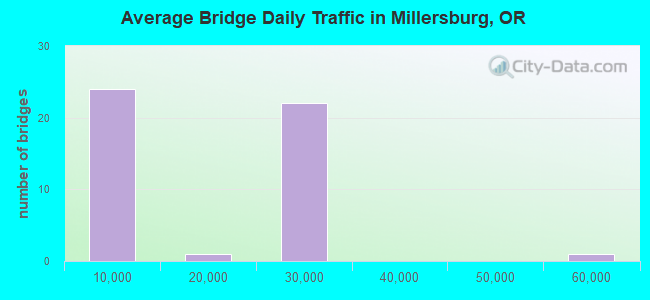
- 755,748Total average daily traffic
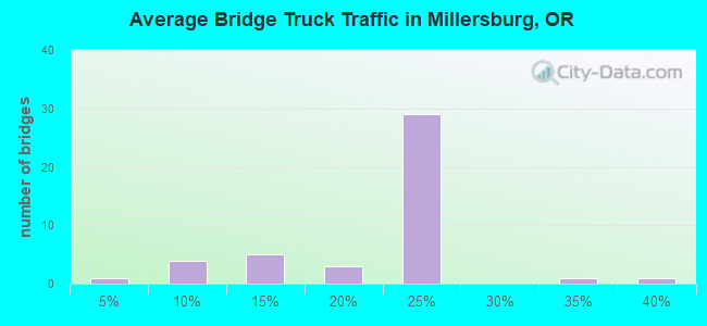
- 154,197Total average daily truck traffic
- National Bridge Inventory (NBI) Registered Bridges for Millersburg
- No street view available for this location
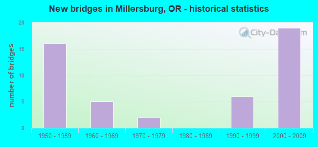
- New bridges - historical statistics
- 161950-1959
- 51960-1969
- 21970-1979
- 61990-1999
- 192000-2009
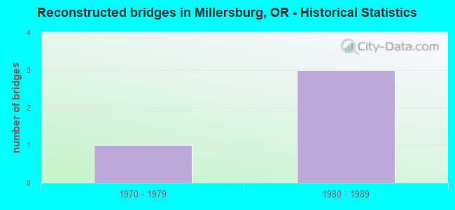
- Reconstructed bridges - Historical Statistics
- 11970-1979
- 31980-1989
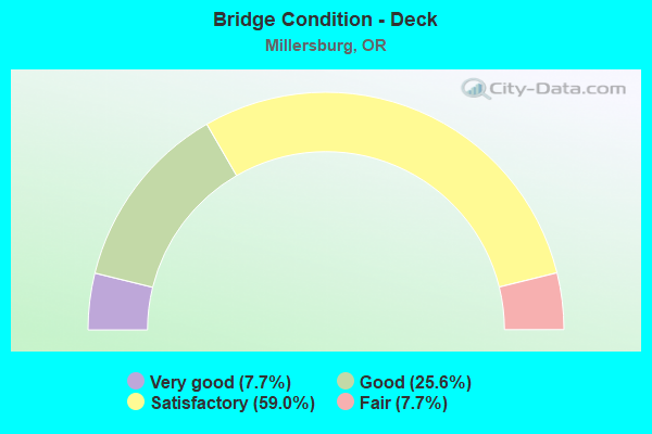
- Bridge Condition - Deck
- 7.7%Very good
- 25.6%Good
- 59.0%Satisfactory
- 7.7%Fair
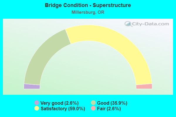
- Bridge Condition - Superstructure
- 2.6%Very good
- 35.9%Good
- 59.0%Satisfactory
- 2.6%Fair
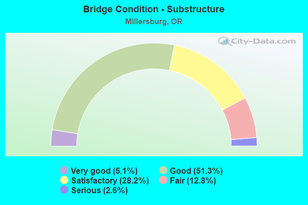
- Bridge Condition - Substructure
- 5.1%Very good
- 51.3%Good
- 28.2%Satisfactory
- 12.8%Fair
- 2.6%Serious
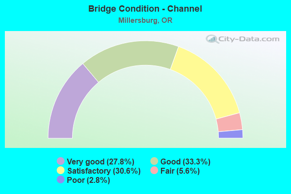
- Bridge Condition - Channel
- 27.8%Very good
- 33.3%Good
- 30.6%Satisfactory
- 5.6%Fair
- 2.8%Poor
Find on map >> Show street view
Structure Number: 622036700261, Location: 3.00 MI NO OF ALBANY (Lat: 44.665719, Lng: -123.060661), Route carried "on" structure: County highway A0500, Year Built: 1955, Year Reconstructed: 1970, Status: Posted for load, Structure Length: 0.94m (3.08ft), Average Daily Traffic: 8,034 (year 2021), Truck Traffic: 20%, Average Future Daily Traffic: 11,227 (year 2041), Design Load: H 20, Features Intersected: MURDER CREEK, Facility Carried by Structure: OLD SALEM RD
Minimum Vertical Clearance: 30+ m (98+ ft), Kilometerpoint: 4.200, Lanes on structure: 2, Owner: County Highway Agency, Approaching Roadway Width: 18.9m (62.0ft), Skew: 33 degrees, Material/Design: Concrete continuous, Design/Construction: Culvert, Number Of Spans In Main Unit: 2, Length of Maximum Span: 4.6m (15.1ft), Curb-To-Curb Width: 19.4m (63.6ft), Out-to-Out Width: 19.4m (63.6ft)
Condition: Channel: Satisfactory, Culverts: Good, Operating Rating: 23.0 metric tons, Method Used To Determine Operating Rating: Field evaluation and documented engineering judgment, Inventory Rating: 17.8 metric tons, Method Used To Determine Inventory Rating: Field evaluation and documented engineering judgment, Structural Evaluation: Meets minimum limits, Deck Geometry: Superior to present desirable criteria, Waterway Adequacy: Equal to present desirable criteria, Approach Roadway Alignment: Equal to present desirable criteria, Bridge Posting: Required (Relationship of Operating Rating to Maximum Legal Load: 0.1 - 9.9% below), Designated Inspection Frequency: Every 24 months, Inspection Date: July 2021, Deck Structure Type: Concrete Cast-file-Place
Find on map >> Show street view
Structure Number: 8121 001 24135, Location: 072 MI N OF ALBANY NCL (Lat: 44.746869, Lng: -123.051989), Route carried "on" structure: Interstate 5, Year Built: 1958, Year Reconstructed: 1992, Status: Open, Structure Length: 7.13m (23.39ft), Average Daily Traffic: 28,905 (year 2020), Truck Traffic: 21%, Average Future Daily Traffic: 36,850 (year 2040), Design Load: HS 20, Features Intersected: Santiam Overflow No. 2
Minimum Vertical Clearance: 30+ m (98+ ft), Kilometerpoint: 388.415, Lanes on structure: 3, Base Highway Network: Yes, Owner: State Highway Agency, Approaching Roadway Width: 21.9m (71.9ft), Material/Design: Concrete continuous, Design/Construction: Tee Beam, Number Of Spans In Main Unit: 6, Length of Maximum Span: 11.9m (39.0ft), Curb-To-Curb Width: 21.9m (71.9ft), Out-to-Out Width: 22.8m (74.8ft)
Condition: Deck: Satisfactory, Superstructure: Satisfactory, Substructure: Satisfactory, Channel: Good, Operating Rating: 48.1 metric tons, Method Used To Determine Operating Rating: Load Factor (LF), Inventory Rating: 29.0 metric tons, Method Used To Determine Inventory Rating: Load Factor (LF), Structural Evaluation: Equal to present minimum criteria, Deck Geometry: Superior to present desirable criteria, Waterway Adequacy: Equal to present desirable criteria, Approach Roadway Alignment: Equal to present desirable criteria, Designated Inspection Frequency: Every 24 months, Inspection Date: Febuary 2021, Deck Structure Type: Concrete Cast-file-Place, Wearing Surface/Protective System: Wearing Surface: Epoxy Overlay, Deck Protection: Epoxy Coated Reinforcing
Find on map >> Show street view
Structure Number: 8122 001 24112, Location: 069 MI N OF ALBANY NCL (Lat: 44.743522, Lng: -123.052272), Route carried "on" structure: Interstate 5, Year Built: 1958, Year Reconstructed: 1991, Status: Open, Structure Length: 3.29m (10.79ft), Average Daily Traffic: 28,859 (year 2020), Truck Traffic: 21%, Average Future Daily Traffic: 36,800 (year 2040), Design Load: HS 20, Features Intersected: Santiam Overflow No. 3
Minimum Vertical Clearance: 30+ m (98+ ft), Kilometerpoint: 388.045, Lanes on structure: 3, Base Highway Network: Yes, Owner: State Highway Agency, Approaching Roadway Width: 25.0m (82.0ft), Material/Design: Concrete continuous, Design/Construction: Tee Beam, Number Of Spans In Main Unit: 3, Length of Maximum Span: 11.0m (36.1ft), Curb-To-Curb Width: 25.0m (82.0ft), Out-to-Out Width: 25.8m (84.6ft)
Condition: Deck: Satisfactory, Superstructure: Satisfactory, Substructure: Good, Channel: Good, Operating Rating: 48.1 metric tons, Method Used To Determine Operating Rating: Load Factor (LF), Inventory Rating: 29.0 metric tons, Method Used To Determine Inventory Rating: Load Factor (LF), Structural Evaluation: Equal to present minimum criteria, Deck Geometry: Superior to present desirable criteria, Waterway Adequacy: Equal to present desirable criteria, Approach Roadway Alignment: Equal to present desirable criteria, Designated Inspection Frequency: Every 24 months, Inspection Date: Febuary 2021, Deck Structure Type: Concrete Cast-file-Place, Wearing Surface/Protective System: Wearing Surface: Epoxy Overlay, Deck Protection: Epoxy Coated Reinforcing
Find on map >> Show street view
Structure Number: 8123D001 24066, Location: 065 MI N OF ALBANY NCL (Lat: 44.737375, Lng: -123.053119), Route carried "on" structure: Interstate 5, Year Built: 1991, Status: Open, Structure Length: 26.21m (85.99ft), Average Daily Traffic: 28,859 (year 2020), Truck Traffic: 21%, Average Future Daily Traffic: 36,800 (year 2040), Design Load: HS 25 or greater, Features Intersected: Santiam River
Minimum Vertical Clearance: 30+ m (98+ ft), Kilometerpoint: 387.305, Lanes on structure: 2, Base Highway Network: Yes, Owner: State Highway Agency, Approaching Roadway Width: 18.3m (60.0ft), Material/Design: Prestressed concrete continuous, Design/Construction: Box Beam or Girders - Multiple, Number Of Spans In Main Unit: 4, Length of Maximum Span: 73.2m (240.2ft), Curb-To-Curb Width: 18.3m (60.0ft), Out-to-Out Width: 19.1m (62.7ft)
Condition: Deck: Good, Superstructure: Good, Substructure: Fair, Channel: Fair, Operating Rating: 18.5 metric tons, Method Used To Determine Operating Rating: Load and Resistance Factor Rating (LRFR) rating reported by rating factor(RF) method using HL-93 loadings, Inventory Rating: 14.3 metric tons, Method Used To Determine Inventory Rating: Load and Resistance Factor Rating (LRFR) rating reported by rating factor(RF) method using HL-93 loadings, Structural Evaluation: High priority of corrective action, Deck Geometry: Superior to present desirable criteria, Waterway Adequacy: Equal to present desirable criteria, Approach Roadway Alignment: Equal to present desirable criteria, Length Of Structure Improvement: 26.20m (85.96ft), Designated Inspection Frequency: Every 24 months, Underwater Inspection Frequency: Every 24 months, Inspection Date: Febuary 2021, Underwater Inspection Date: June 2021, Bridge Improvement Cost: $2,754,000, Roadway Improvement Cost: $275,000, Total Project Cost: $4,406,000, Deck Structure Type: Concrete Cast-file-Place, Wearing Surface/Protective System: Wearing Surface: Monolithic Concrete, Deck Protection: Epoxy Coated Reinforcing
Find on map >> Show street view
Structure Number: 8124 001 24042, Location: 06.2 MI N OF ALBANY NCL (Lat: 44.733431, Lng: -123.053303), Route carried "on" structure: Interstate 5, Year Built: 1958, Year Reconstructed: 1992, Status: Open, Structure Length: 5.18m (16.99ft), Average Daily Traffic: 28,859 (year 2020), Truck Traffic: 21%, Average Future Daily Traffic: 36,800 (year 2040), Design Load: HS 20, Features Intersected: Santiam Overflow No. 4
Minimum Vertical Clearance: 30+ m (98+ ft), Kilometerpoint: 386.918, Lanes on structure: 2, Base Highway Network: Yes, Owner: State Highway Agency, Approaching Roadway Width: 19.2m (63.0ft), Material/Design: Concrete continuous, Design/Construction: Tee Beam, Number Of Spans In Main Unit: 5, Length of Maximum Span: 11.0m (36.1ft), Curb-To-Curb Width: 19.3m (63.3ft), Out-to-Out Width: 20.5m (67.3ft)
Condition: Deck: Satisfactory, Superstructure: Satisfactory, Substructure: Satisfactory, Channel: Good, Operating Rating: 50.8 metric tons, Method Used To Determine Operating Rating: Load Factor (LF), Inventory Rating: 30.8 metric tons, Method Used To Determine Inventory Rating: Load Factor (LF), Structural Evaluation: Equal to present minimum criteria, Deck Geometry: Superior to present desirable criteria, Waterway Adequacy: Equal to present desirable criteria, Approach Roadway Alignment: Equal to present desirable criteria, Designated Inspection Frequency: Every 24 months, Inspection Date: Febuary 2021, Deck Structure Type: Concrete Cast-file-Place, Wearing Surface/Protective System: Wearing Surface: Epoxy Overlay, Deck Protection: Epoxy Coated Reinforcing
Find on map >> Show street view
Structure Number: 8130 001 23967, Location: 055 MI N OF ALBANY (Lat: 44.722667, Lng: -123.054150), Route carried "on" structure: County highway , Year Built: 1958, Status: Open, Structure Length: 9.27m (30.41ft), Average Daily Traffic: 997 (year 2010), Truck Traffic: 5%, Average Future Daily Traffic: 1,360 (year 2030), Design Load: HS 20, Features Intersected: I-5 (Hwy 1), Facility Carried by Structure: Dever-Conner Road
Minimum Vertical Clearance: 30+ m (98+ ft), Kilometerpoint: 385.711, Lanes on structure: 2, Lanes under structure: 6, Owner: State Highway Agency, Approaching Roadway Width: 9.1m (29.9ft), Material/Design: Concrete continuous, Design/Construction: Tee Beam, Number Of Spans In Main Unit: 5, Length of Maximum Span: 25.6m (84.0ft), Curb-To-Curb Width: 7.9m (25.9ft), Out-to-Out Width: 9.4m (30.8ft)
Condition: Deck: Satisfactory, Superstructure: Satisfactory, Substructure: Satisfactory, Operating Rating: 26.6 metric tons, Method Used To Determine Operating Rating: Load and Resistance Factor Rating (LRFR) rating reported by rating factor(RF) method using HL-93 loadings, Inventory Rating: 20.4 metric tons, Method Used To Determine Inventory Rating: Load and Resistance Factor Rating (LRFR) rating reported by rating factor(RF) method using HL-93 loadings, Structural Evaluation: Somewhat better than minimum adequacy, Deck Geometry: Somewhat better than minimum adequacy, Underclear: Somewhat better than minimum adequacy, Approach Roadway Alignment: Equal to present desirable criteria, Designated Inspection Frequency: Every 24 months, Inspection Date: Febuary 2021, Deck Structure Type: Concrete Cast-file-Place
Find on map >> Show street view
Structure Number: 8132 001 23767, Location: 035 MI N OF ALBANY (Lat: 44.693811, Lng: -123.052322), Route carried "on" structure: County highway , Year Built: 1958, Status: Open, Structure Length: 8.02m (26.31ft), Average Daily Traffic: 14,974 (year 2010), Truck Traffic: 5%, Average Future Daily Traffic: 20,456 (year 2030), Design Load: HS 20, Features Intersected: I-5 (HWY 1), Facility Carried by Structure: Viewcrest Road
Minimum Vertical Clearance: 30+ m (98+ ft), Kilometerpoint: 382.493, Lanes on structure: 2, Lanes under structure: 4, Owner: State Highway Agency, Approaching Roadway Width: 7.3m (24.0ft), Material/Design: Concrete continuous, Design/Construction: Tee Beam, Number Of Spans In Main Unit: 5, Length of Maximum Span: 18.0m (59.1ft), Curb-To-Curb Width: 7.3m (24.0ft), Out-to-Out Width: 8.8m (28.9ft)
Condition: Deck: Fair, Superstructure: Satisfactory, Substructure: Satisfactory, Operating Rating: 38.1 metric tons, Method Used To Determine Operating Rating: Load Factor (LF), Inventory Rating: 22.7 metric tons, Method Used To Determine Inventory Rating: Load Factor (LF), Structural Evaluation: Somewhat better than minimum adequacy, Deck Geometry: High priority of replacement, Underclear: Meets minimum limits, Approach Roadway Alignment: Equal to present desirable criteria, Length Of Structure Improvement: 8.00m (26.25ft), Designated Inspection Frequency: Every 24 months, Inspection Date: January 2021, Bridge Improvement Cost: $787,000, Roadway Improvement Cost: $79,000, Total Project Cost: $1,259,000, Deck Structure Type: Concrete Cast-file-Place
Find on map >> Show street view
Structure Number: 8217 001 23571, Location: 015 MI N OF ALBANY NCL (Lat: 44.666072, Lng: -123.059044), Route carried "on" structure: Interstate 5, Year Built: 1958, Status: Open, Structure Length: 3.84m (12.60ft), Average Daily Traffic: 29,068 (year 2020), Truck Traffic: 21%, Average Future Daily Traffic: 42,250 (year 2040), Design Load: HS 20, Features Intersected: Murder Creek
Minimum Vertical Clearance: 30+ m (98+ ft), Kilometerpoint: 379.338, Lanes on structure: 2, Base Highway Network: Yes, Owner: State Highway Agency, Approaching Roadway Width: 12.2m (40.0ft), Material/Design: Concrete continuous, Design/Construction: Tee Beam, Number Of Spans In Main Unit: 3, Length of Maximum Span: 12.8m (42.0ft), Curb-To-Curb Width: 12.2m (40.0ft), Out-to-Out Width: 13.7m (44.9ft)
Condition: Deck: Satisfactory, Superstructure: Satisfactory, Substructure: Good, Channel: Good, Operating Rating: 41.7 metric tons, Method Used To Determine Operating Rating: Load Factor (LF), Inventory Rating: 25.4 metric tons, Method Used To Determine Inventory Rating: Load Factor (LF), Structural Evaluation: Equal to present minimum criteria, Deck Geometry: Better than present minimum criteria, Waterway Adequacy: Equal to present desirable criteria, Approach Roadway Alignment: Equal to present desirable criteria, Designated Inspection Frequency: Every 24 months, Inspection Date: January 2021, Deck Structure Type: Concrete Cast-file-Place, Wearing Surface/Protective System: Wearing Surface: Bituminous
Find on map >> Show street view
Structure Number: 8218A001 23567, Location: 015 MI N OF ALBANY NCL (Lat: 44.665414, Lng: -123.058769), Route carried "on" structure: Interstate 5, Year Built: 1958, Status: Open, Structure Length: 3.99m (13.09ft), Average Daily Traffic: 29,068 (year 2020), Truck Traffic: 21%, Average Future Daily Traffic: 42,250 (year 2040), Design Load: HS 20, Features Intersected: Murder Creek Road
Minimum Vertical Clearance: 30+ m (98+ ft), Kilometerpoint: 379.274, Lanes on structure: 2, Lanes under structure: 2, Base Highway Network: Yes, Owner: State Highway Agency, Approaching Roadway Width: 12.2m (40.0ft), Material/Design: Concrete continuous, Design/Construction: Tee Beam, Number Of Spans In Main Unit: 3, Length of Maximum Span: 14.3m (46.9ft), Curb-To-Curb Width: 12.2m (40.0ft), Out-to-Out Width: 13.7m (44.9ft)
Condition: Deck: Satisfactory, Superstructure: Satisfactory, Substructure: Satisfactory, Operating Rating: 56.2 metric tons, Method Used To Determine Operating Rating: Load Factor (LF), Inventory Rating: 33.6 metric tons, Method Used To Determine Inventory Rating: Load Factor (LF), Structural Evaluation: Equal to present minimum criteria, Deck Geometry: Better than present minimum criteria, Underclear: Meets minimum limits, Approach Roadway Alignment: Equal to present desirable criteria, Designated Inspection Frequency: Every 24 months, Inspection Date: January 2021, Deck Structure Type: Concrete Cast-file-Place, Wearing Surface/Protective System: Wearing Surface: Bituminous
Find on map >> Show street view
Structure Number: 8218B001 23567, Location: 015 MI N OF ALBANY NCL (Lat: 44.665458, Lng: -123.059161), Route carried "on" structure: Interstate 5, Year Built: 1958, Status: Open, Structure Length: 3.99m (13.09ft), Average Daily Traffic: 29,068 (year 2020), Truck Traffic: 21%, Average Future Daily Traffic: 42,250 (year 2040), Design Load: HS 20, Features Intersected: Murder Creek Road
Minimum Vertical Clearance: 30+ m (98+ ft), Kilometerpoint: 379.274, Lanes on structure: 2, Lanes under structure: 2, Base Highway Network: Yes, Owner: State Highway Agency, Approaching Roadway Width: 12.2m (40.0ft), Material/Design: Concrete continuous, Design/Construction: Tee Beam, Number Of Spans In Main Unit: 3, Length of Maximum Span: 14.3m (46.9ft), Curb-To-Curb Width: 12.2m (40.0ft), Out-to-Out Width: 13.7m (44.9ft)
Condition: Deck: Satisfactory, Superstructure: Satisfactory, Substructure: Satisfactory, Operating Rating: 56.2 metric tons, Method Used To Determine Operating Rating: Load Factor (LF), Inventory Rating: 33.6 metric tons, Method Used To Determine Inventory Rating: Load Factor (LF), Structural Evaluation: Equal to present minimum criteria, Deck Geometry: Better than present minimum criteria, Underclear: Meets minimum limits, Approach Roadway Alignment: Equal to present desirable criteria, Designated Inspection Frequency: Every 24 months, Inspection Date: January 2021, Deck Structure Type: Concrete Cast-file-Place, Wearing Surface/Protective System: Wearing Surface: Bituminous
Find on map >> Show street view
Structure Number: 8219 001F23573, Location: 015 MI N OF ALBANY NCL (Lat: 44.665758, Lng: -123.057878), Route carried "on" structure: ServiceInterstate 5, Year Built: 1958, Status: Open, Structure Length: 2.19m (7.19ft), Average Daily Traffic: 722 (year 2020), Truck Traffic: 21%, Average Future Daily Traffic: 780 (year 2030), Design Load: HS 20, Features Intersected: Murder Creek
Minimum Vertical Clearance: 30+ m (98+ ft), Kilometerpoint: 379.371, Lanes on structure: 2, Base Highway Network: Yes, Owner: State Highway Agency, Approaching Roadway Width: 7.9m (25.9ft), Material/Design: Concrete continuous, Design/Construction: Tee Beam, Number Of Spans In Main Unit: 3, Length of Maximum Span: 14.6m (47.9ft), Curb-To-Curb Width: 7.9m (25.9ft), Out-to-Out Width: 9.4m (30.8ft)
Condition: Deck: Satisfactory, Superstructure: Satisfactory, Substructure: Good, Channel: Satisfactory, Operating Rating: 47.2 metric tons, Method Used To Determine Operating Rating: Load Factor (LF), Inventory Rating: 28.1 metric tons, Method Used To Determine Inventory Rating: Load Factor (LF), Structural Evaluation: Equal to present minimum criteria, Deck Geometry: Somewhat better than minimum adequacy, Waterway Adequacy: Equal to present desirable criteria, Approach Roadway Alignment: Equal to present desirable criteria, Designated Inspection Frequency: Every 24 months, Inspection Date: January 2021, Deck Structure Type: Concrete Cast-file-Place, Wearing Surface/Protective System: Wearing Surface: Bituminous
Find on map >> Show street view
Structure Number: 12734 031700245, Location: 0002 MI WEST I5 (Lat: 44.665161, Lng: -123.056969), Route carried "on" structure: County highway C0317, Year Built: 1975, Status: Open, Structure Length: 1.22m (4.00ft), Average Daily Traffic: 309 (year 2021), Truck Traffic: 10%, Average Future Daily Traffic: 464 (year 2041), Design Load: HS 20, Features Intersected: MURDER CREEK, Facility Carried by Structure: KENWORTHY RD
Minimum Vertical Clearance: 30+ m (98+ ft), Kilometerpoint: 3.943, Lanes on structure: 2, Owner: County Highway Agency, Approaching Roadway Width: 6.4m (21.0ft), Material/Design: Prestressed concrete, Design/Construction: Slab, Number Of Spans In Main Unit: 1, Length of Maximum Span: 11.9m (39.0ft), Curb or Sidewalk Widths: Left: 0.2m (0.7ft), Right: 0.2m (0.7ft), Curb-To-Curb Width: 7.9m (25.9ft), Out-to-Out Width: 8.5m (27.9ft)
Condition: Deck: Good, Superstructure: Good, Substructure: Good, Channel: Satisfactory, Operating Rating: 68.9 metric tons, Method Used To Determine Operating Rating: Load Factor (LF), Inventory Rating: 37.2 metric tons, Method Used To Determine Inventory Rating: Load Factor (LF), Structural Evaluation: Better than present minimum criteria, Deck Geometry: Somewhat better than minimum adequacy, Waterway Adequacy: Equal to present desirable criteria, Approach Roadway Alignment: Equal to present desirable criteria, Designated Inspection Frequency: Every 24 months, Inspection Date: July 2021, Deck Structure Type: Other, Wearing Surface/Protective System: Wearing Surface: Bituminous
Find on map >> Show street view
Structure Number: 12752 0324, Location: 000 AT ALBANY SEWER PLANT (Lat: 44.644050, Lng: -123.074019), Route carried "on" structure: County highway C0324, Year Built: 1957, Status: Posted for load, Structure Length: 3.54m (11.61ft), Average Daily Traffic: 154 (year 2021), Truck Traffic: 30%, Average Future Daily Traffic: 206 (year 2041), Design Load: HS 20, Features Intersected: COX CREEK, Facility Carried by Structure: WAVERLY DR. NORTH
Minimum Vertical Clearance: 30+ m (98+ ft), Kilometerpoint: 0.000, Lanes on structure: 2, Owner: City or Municipal Highway Agency, Approaching Roadway Width: 7.3m (24.0ft), Material/Design: Concrete, Design/Construction: Channel Beam, Number Of Spans In Main Unit: 6, Length of Maximum Span: 5.8m (19.0ft), Curb or Sidewalk Widths: Left: 0.5m (1.6ft), Right: 0.5m (1.6ft), Curb-To-Curb Width: 8.0m (26.2ft), Out-to-Out Width: 9.0m (29.5ft)
Condition: Deck: Satisfactory, Superstructure: Satisfactory, Substructure: Serious, Channel: Poor, Operating Rating: 29.2 metric tons, Method Used To Determine Operating Rating: Load and Resistance Factor Rating (LRFR) rating reported by rating factor(RF) method using HL-93 loadings, Inventory Rating: 22.4 metric tons, Method Used To Determine Inventory Rating: Load and Resistance Factor Rating (LRFR) rating reported by rating factor(RF) method using HL-93 loadings, Structural Evaluation: High priority of corrective action, Waterway Adequacy: Equal to present desirable criteria, Approach Roadway Alignment: Equal to present desirable criteria, Bridge Posting: Required (Relationship of Operating Rating to Maximum Legal Load: 10.0 - 19.9% below), Length Of Structure Improvement: 3.90m (12.80ft), Designated Inspection Frequency: Every 12 months, Inspection Date: July 2021, Bridge Improvement Cost: $409,000, Roadway Improvement Cost: $41,000, Total Project Cost: $654,000, Deck Structure Type: Concrete Precast Panels, Wearing Surface/Protective System: Wearing Surface: Bituminous
Find on map >> Show street view
Structure Number: 12772 031100148, Location: 3.0 MI NW MILLERSBURG (Lat: 44.706389, Lng: -123.101731), Route carried "on" structure: County highway C0311, Year Built: 1959, Status: Open, Structure Length: 1.49m (4.89ft), Average Daily Traffic: 206 (year 2021), Truck Traffic: 10%, Average Future Daily Traffic: 288 (year 2041), Design Load: H 20, Features Intersected: DITCH, Facility Carried by Structure: GROSHONG ROAD
Minimum Vertical Clearance: 30+ m (98+ ft), Kilometerpoint: 2.382, Lanes on structure: 2, Owner: County Highway Agency, Approaching Roadway Width: 6.4m (21.0ft), Material/Design: Concrete, Design/Construction: Channel Beam, Number Of Spans In Main Unit: 3, Length of Maximum Span: 5.8m (19.0ft), Curb or Sidewalk Widths: Left: 0.4m (1.3ft), Right: 0.4m (1.3ft), Curb-To-Curb Width: 6.9m (22.6ft), Out-to-Out Width: 7.7m (25.3ft)
Condition: Deck: Satisfactory, Superstructure: Fair, Substructure: Fair, Channel: Satisfactory, Operating Rating: 38.2 metric tons, Method Used To Determine Operating Rating: Load and Resistance Factor Rating (LRFR) rating reported by rating factor(RF) method using HL-93 loadings, Inventory Rating: 29.5 metric tons, Method Used To Determine Inventory Rating: Load and Resistance Factor Rating (LRFR) rating reported by rating factor(RF) method using HL-93 loadings, Structural Evaluation: Somewhat better than minimum adequacy, Deck Geometry: Meets minimum limits, Waterway Adequacy: Equal to present desirable criteria, Approach Roadway Alignment: Equal to present desirable criteria, Designated Inspection Frequency: Every 24 months, Inspection Date: July 2021, Deck Structure Type: Concrete Precast Panels, Wearing Surface/Protective System: Wearing Surface: Bituminous
Find on map >> Show street view
Structure Number: 12774 0302 239, Location: 035MI WEST I5 (Lat: 44.730161, Lng: -123.119339), Route carried "on" structure: County highway C0302, Year Built: 1967, Status: Open, Structure Length: 1.86m (6.10ft), Average Daily Traffic: 93 (year 2021), Average Future Daily Traffic: 129 (year 2041), Design Load: HS 20, Features Intersected: CROOKS CREEK, Facility Carried by Structure: COOPER ROAD
Minimum Vertical Clearance: 30+ m (98+ ft), Kilometerpoint: 3.846, Lanes on structure: 2, Owner: County Highway Agency, Approaching Roadway Width: 6.7m (22.0ft), Material/Design: Prestressed concrete, Design/Construction: Slab, Number Of Spans In Main Unit: 2, Length of Maximum Span: 9.1m (29.9ft), Curb or Sidewalk Widths: Left: 0.2m (0.7ft), Right: 0.2m (0.7ft), Curb-To-Curb Width: 6.7m (22.0ft), Out-to-Out Width: 7.4m (24.3ft)
Condition: Deck: Good, Superstructure: Good, Substructure: Satisfactory, Channel: Good, Operating Rating: 46.0 metric tons, Method Used To Determine Operating Rating: Load and Resistance Factor Rating (LRFR) rating reported by rating factor(RF) method using HL-93 loadings, Inventory Rating: 27.9 metric tons, Method Used To Determine Inventory Rating: Load and Resistance Factor Rating (LRFR) rating reported by rating factor(RF) method using HL-93 loadings, Structural Evaluation: Equal to present minimum criteria, Deck Geometry: Somewhat better than minimum adequacy, Waterway Adequacy: Equal to present desirable criteria, Approach Roadway Alignment: Equal to present minimum criteria, Designated Inspection Frequency: Every 24 months, Inspection Date: July 2021, Deck Structure Type: Other, Wearing Surface/Protective System: Wearing Surface: Bituminous
Find on map >> Show street view
Structure Number: 12778A003400126, Location: 030 MI N MILLERSBURG (Lat: 44.719175, Lng: -123.077364), Route carried "on" structure: County highway A0500, Year Built: 1962, Status: Open, Structure Length: 0.91m (2.99ft), Average Daily Traffic: 566 (year 2021), Truck Traffic: 15%, Average Future Daily Traffic: 798 (year 2041), Design Load: HS 20, Features Intersected: CROOKS CREEK, Facility Carried by Structure: DEVER-CONNER ROAD
Minimum Vertical Clearance: 3.05m (10.01ft), Kilometerpoint: 2.028, Lanes on structure: 2, Owner: County Highway Agency, Approaching Roadway Width: 7.6m (24.9ft), Material/Design: Prestressed concrete, Design/Construction: Slab, Number Of Spans In Main Unit: 1, Length of Maximum Span: 8.8m (28.9ft), Curb or Sidewalk Widths: Left: 0.4m (1.3ft), Right: 0.4m (1.3ft), Curb-To-Curb Width: 7.7m (25.3ft), Out-to-Out Width: 8.6m (28.2ft)
Condition: Deck: Good, Superstructure: Good, Substructure: Fair, Channel: Fair, Operating Rating: 32.7 metric tons, Method Used To Determine Operating Rating: Load Factor (LF), Inventory Rating: 20.0 metric tons, Method Used To Determine Inventory Rating: Load Factor (LF), Structural Evaluation: Somewhat better than minimum adequacy, Deck Geometry: Meets minimum limits, Waterway Adequacy: Equal to present desirable criteria, Approach Roadway Alignment: Equal to present desirable criteria, Designated Inspection Frequency: Every 24 months, Inspection Date: July 2021, Deck Structure Type: Other, Wearing Surface/Protective System: Wearing Surface: Bituminous
Find on map >> Show street view
Structure Number: 12780 003400172, Location: 0172 MI WEST I5 (Lat: 44.719231, Lng: -123.086800), Route carried "on" structure: County highway A0500, Year Built: 1968, Status: Open, Structure Length: 2.32m (7.61ft), Average Daily Traffic: 309 (year 2021), Truck Traffic: 15%, Average Future Daily Traffic: 438 (year 2041), Design Load: HS 20, Features Intersected: CROOKS CREEK, Facility Carried by Structure: DEVER-CONNER ROAD
Minimum Vertical Clearance: 30+ m (98+ ft), Kilometerpoint: 2.768, Lanes on structure: 2, Owner: County Highway Agency, Approaching Roadway Width: 7.9m (25.9ft), Material/Design: Prestressed concrete, Design/Construction: Slab, Number Of Spans In Main Unit: 2, Length of Maximum Span: 11.3m (37.1ft), Curb or Sidewalk Widths: Left: 0.2m (0.7ft), Right: 0.2m (0.7ft), Curb-To-Curb Width: 10.4m (34.1ft), Out-to-Out Width: 11.0m (36.1ft)
Condition: Deck: Good, Superstructure: Good, Substructure: Satisfactory, Channel: Satisfactory, Operating Rating: 82.6 metric tons, Method Used To Determine Operating Rating: Load Factor (LF), Inventory Rating: 49.0 metric tons, Method Used To Determine Inventory Rating: Load Factor (LF), Structural Evaluation: Equal to present minimum criteria, Deck Geometry: Better than present minimum criteria, Waterway Adequacy: Equal to present desirable criteria, Approach Roadway Alignment: Equal to present desirable criteria, Length Of Structure Improvement: 3.00m (9.84ft), Designated Inspection Frequency: Every 24 months, Inspection Date: July 2021, Bridge Improvement Cost: $316,000, Roadway Improvement Cost: $32,000, Total Project Cost: $506,000, Deck Structure Type: Other, Wearing Surface/Protective System: Wearing Surface: Bituminous
Find on map >> Show street view
Structure Number: 17191 001 24112, Location: 1/2 N OF SANTIAM RIVER (Lat: 44.743325, Lng: -123.053600), Route carried "on" structure: Ramp Interstate 5, Year Built: 1992, Status: Open, Structure Length: 4.27m (14.01ft), Average Daily Traffic: 1,083 (year 2020), Truck Traffic: 21%, Average Future Daily Traffic: 2,200 (year 2030), Design Load: HS 25 or greater, Features Intersected: Santiam Overflow No. 3
Minimum Vertical Clearance: 30+ m (98+ ft), Kilometerpoint: 388.045, Lanes on structure: 2, Base Highway Network: Yes, Owner: State Highway Agency, Approaching Roadway Width: 14.6m (47.9ft), Material/Design: Concrete continuous, Design/Construction: Slab, Number Of Spans In Main Unit: 3, Length of Maximum Span: 17.1m (56.1ft), Curb-To-Curb Width: 14.6m (47.9ft), Out-to-Out Width: 15.4m (50.5ft)
Condition: Deck: Satisfactory, Superstructure: Satisfactory, Substructure: Good, Channel: Very good, Operating Rating: 35.0 metric tons, Method Used To Determine Operating Rating: Load and Resistance Factor Rating (LRFR) rating reported by rating factor(RF) method using HL-93 loadings, Inventory Rating: 26.9 metric tons, Method Used To Determine Inventory Rating: Load and Resistance Factor Rating (LRFR) rating reported by rating factor(RF) method using HL-93 loadings, Structural Evaluation: Equal to present minimum criteria, Deck Geometry: Superior to present desirable criteria, Waterway Adequacy: Equal to present desirable criteria, Approach Roadway Alignment: Equal to present desirable criteria, Designated Inspection Frequency: Every 24 months, Inspection Date: Febuary 2021, Deck Structure Type: Concrete Cast-file-Place, Wearing Surface/Protective System: Wearing Surface: Epoxy Overlay, Deck Protection: Epoxy Coated Reinforcing
Find on map >> Show street view
Structure Number: 17318 001 24066, Location: 065 MI N OF ALBANY NCL (Lat: 44.737400, Lng: -123.052567), Route carried "on" structure: Interstate 5, Year Built: 1995, Status: Open, Structure Length: 26.21m (85.99ft), Average Daily Traffic: 28,859 (year 2020), Truck Traffic: 21%, Average Future Daily Traffic: 36,800 (year 2040), Design Load: HS 25 or greater, Features Intersected: Santiam River
Minimum Vertical Clearance: 30+ m (98+ ft), Kilometerpoint: 387.353, Lanes on structure: 3, Base Highway Network: Yes, Owner: State Highway Agency, Approaching Roadway Width: 18.3m (60.0ft), Material/Design: Prestressed concrete continuous, Design/Construction: Box Beam or Girders - Multiple, Number Of Spans In Main Unit: 4, Length of Maximum Span: 73.2m (240.2ft), Curb-To-Curb Width: 18.3m (60.0ft), Out-to-Out Width: 19.1m (62.7ft)
Condition: Deck: Satisfactory, Superstructure: Good, Substructure: Good, Channel: Satisfactory, Operating Rating: 30.1 metric tons, Method Used To Determine Operating Rating: Load and Resistance Factor Rating (LRFR) rating reported by rating factor(RF) method using HL-93 loadings, Inventory Rating: 23.3 metric tons, Method Used To Determine Inventory Rating: Load and Resistance Factor Rating (LRFR) rating reported by rating factor(RF) method using HL-93 loadings, Structural Evaluation: Somewhat better than minimum adequacy, Deck Geometry: Better than present minimum criteria, Waterway Adequacy: Equal to present desirable criteria, Approach Roadway Alignment: Equal to present desirable criteria, Length Of Structure Improvement: 26.20m (85.96ft), Designated Inspection Frequency: Every 24 months, Underwater Inspection Frequency: Every 36 months, Inspection Date: Febuary 2021, Underwater Inspection Date: June 2021, Bridge Improvement Cost: $2,754,000, Roadway Improvement Cost: $275,000, Total Project Cost: $4,406,000, Deck Structure Type: Concrete Cast-file-Place, Wearing Surface/Protective System: Wearing Surface: Monolithic Concrete, Deck Protection: Epoxy Coated Reinforcing
Find on map >> Show street view
Structure Number: 17342 001 24042, Location: 6.2 MI N OF ALBANY (Lat: 44.733503, Lng: -123.052897), Route carried "on" structure: Interstate 5, Year Built: 1994, Status: Open, Structure Length: 5.18m (16.99ft), Average Daily Traffic: 28,859 (year 2020), Truck Traffic: 21%, Average Future Daily Traffic: 36,800 (year 2040), Design Load: HS 25 or greater, Features Intersected: Santiam Overflow No. 4
Minimum Vertical Clearance: 30+ m (98+ ft), Kilometerpoint: 386.918, Lanes on structure: 3, Base Highway Network: Yes, Owner: State Highway Agency, Approaching Roadway Width: 18.3m (60.0ft), Material/Design: Concrete continuous, Design/Construction: Tee Beam, Number Of Spans In Main Unit: 4, Length of Maximum Span: 13.1m (43.0ft), Curb-To-Curb Width: 18.3m (60.0ft), Out-to-Out Width: 19.1m (62.7ft)
Condition: Deck: Fair, Superstructure: Satisfactory, Substructure: Good, Channel: Very good, Operating Rating: 52.5 metric tons, Method Used To Determine Operating Rating: Load and Resistance Factor Rating (LRFR) rating reported by rating factor(RF) method using HL-93 loadings, Inventory Rating: 40.5 metric tons, Method Used To Determine Inventory Rating: Load and Resistance Factor Rating (LRFR) rating reported by rating factor(RF) method using HL-93 loadings, Structural Evaluation: Equal to present minimum criteria, Deck Geometry: Better than present minimum criteria, Waterway Adequacy: Equal to present desirable criteria, Approach Roadway Alignment: Equal to present desirable criteria, Designated Inspection Frequency: Every 24 months, Inspection Date: Febuary 2021, Deck Structure Type: Concrete Cast-file-Place, Wearing Surface/Protective System: Wearing Surface: Epoxy Overlay, Deck Protection: Epoxy Coated Reinforcing
Find on map >> Show street view
Structure Number: 17351 001 24135, Location: 7.2 MI N OF ALBANY (Lat: 44.746742, Lng: -123.051547), Route carried "on" structure: Interstate 5, Year Built: 1994, Status: Open, Structure Length: 7.13m (23.39ft), Average Daily Traffic: 28,905 (year 2020), Truck Traffic: 21%, Average Future Daily Traffic: 36,850 (year 2040), Design Load: HS 25 or greater, Features Intersected: Santiam Overflow No. 2
Minimum Vertical Clearance: 30+ m (98+ ft), Kilometerpoint: 388.415, Lanes on structure: 3, Base Highway Network: Yes, Owner: State Highway Agency, Approaching Roadway Width: 18.3m (60.0ft), Material/Design: Concrete continuous, Design/Construction: Tee Beam, Number Of Spans In Main Unit: 6, Length of Maximum Span: 11.9m (39.0ft), Curb-To-Curb Width: 18.3m (60.0ft), Out-to-Out Width: 19.1m (62.7ft)
Condition: Deck: Fair, Superstructure: Satisfactory, Substructure: Satisfactory, Channel: Good, Operating Rating: 23.7 metric tons, Method Used To Determine Operating Rating: Load and Resistance Factor Rating (LRFR) rating reported by rating factor(RF) method using HL-93 loadings, Inventory Rating: 18.1 metric tons, Method Used To Determine Inventory Rating: Load and Resistance Factor Rating (LRFR) rating reported by rating factor(RF) method using HL-93 loadings, Structural Evaluation: Meets minimum limits, Deck Geometry: Better than present minimum criteria, Waterway Adequacy: Equal to present desirable criteria, Approach Roadway Alignment: Equal to present desirable criteria, Designated Inspection Frequency: Every 24 months, Inspection Date: Febuary 2021, Deck Structure Type: Concrete Cast-file-Place, Wearing Surface/Protective System: Wearing Surface: Monolithic Concrete, Deck Protection: Epoxy Coated Reinforcing
Find on map >> Show street view
Structure Number: 17352 001 24112, Location: 6.9 MI N OF ALBANY NCL (Lat: 44.743489, Lng: -123.051864), Route carried "on" structure: Interstate 5, Year Built: 1994, Status: Open, Structure Length: 3.29m (10.79ft), Average Daily Traffic: 28,859 (year 2020), Truck Traffic: 21%, Average Future Daily Traffic: 36,800 (year 2040), Design Load: HS 25 or greater, Features Intersected: Santiam Overflow No. 3
Minimum Vertical Clearance: 30+ m (98+ ft), Kilometerpoint: 388.045, Lanes on structure: 3, Base Highway Network: Yes, Owner: State Highway Agency, Approaching Roadway Width: 25.6m (84.0ft), Material/Design: Concrete continuous, Design/Construction: Tee Beam, Number Of Spans In Main Unit: 3, Length of Maximum Span: 11.0m (36.1ft), Curb-To-Curb Width: 25.6m (84.0ft), Out-to-Out Width: 26.4m (86.6ft)
Condition: Deck: Satisfactory, Superstructure: Satisfactory, Substructure: Good, Channel: Good, Operating Rating: 24.0 metric tons, Method Used To Determine Operating Rating: Load and Resistance Factor Rating (LRFR) rating reported by rating factor(RF) method using HL-93 loadings, Inventory Rating: 18.5 metric tons, Method Used To Determine Inventory Rating: Load and Resistance Factor Rating (LRFR) rating reported by rating factor(RF) method using HL-93 loadings, Structural Evaluation: Meets minimum limits, Deck Geometry: Superior to present desirable criteria, Waterway Adequacy: Equal to present desirable criteria, Approach Roadway Alignment: Equal to present desirable criteria, Designated Inspection Frequency: Every 24 months, Inspection Date: Febuary 2021, Deck Structure Type: Concrete Cast-file-Place, Wearing Surface/Protective System: Wearing Surface: Epoxy Overlay, Deck Protection: Epoxy Coated Reinforcing
Find on map >> Show street view
Structure Number: 18346 001 23571, Location: 015 MI N OF ALBANY NCL (Lat: 44.665947, Lng: -123.058661), Route carried "on" structure: Interstate 5, Year Built: 2001, Status: Open, Structure Length: 3.40m (11.15ft), Average Daily Traffic: 29,068 (year 2020), Truck Traffic: 21%, Average Future Daily Traffic: 42,250 (year 2040), Design Load: HL 93, Features Intersected: Murder Creek
Minimum Vertical Clearance: 30+ m (98+ ft), Kilometerpoint: 379.338, Lanes on structure: 2, Base Highway Network: Yes, Owner: State Highway Agency, Approaching Roadway Width: 12.6m (41.3ft), Material/Design: Prestressed concrete, Design/Construction: Stringer/Multi-beam, Number Of Spans In Main Unit: 1, Length of Maximum Span: 34.0m (111.5ft), Curb-To-Curb Width: 12.6m (41.3ft), Out-to-Out Width: 13.4m (44.0ft)
Condition: Deck: Satisfactory, Superstructure: Good, Substructure: Satisfactory, Channel: Good, Operating Rating: 59.3 metric tons, Method Used To Determine Operating Rating: Load and Resistance Factor Rating (LRFR) rating reported by rating factor(RF) method using HL-93 loadings, Inventory Rating: 45.7 metric tons, Method Used To Determine Inventory Rating: Load and Resistance Factor Rating (LRFR) rating reported by rating factor(RF) method using HL-93 loadings, Structural Evaluation: Equal to present minimum criteria, Deck Geometry: Better than present minimum criteria, Waterway Adequacy: Equal to present desirable criteria, Approach Roadway Alignment: Equal to present desirable criteria, Designated Inspection Frequency: Every 24 months, Inspection Date: January 2021, Deck Structure Type: Concrete Cast-file-Place, Wearing Surface/Protective System: Wearing Surface: Monolithic Concrete, Deck Protection: Epoxy Coated Reinforcing
Find on map >> Show street view
Structure Number: 18347 001 23822, Location: 040 MI N OF ALBANY NCL (Lat: 44.701861, Lng: -123.051919), Route carried "on" structure: Interstate 5, Year Built: 2001, Status: Open, Structure Length: 12.20m (40.03ft), Average Daily Traffic: 28,820 (year 2020), Truck Traffic: 21%, Average Future Daily Traffic: 41,850 (year 2040), Design Load: HL 93, Features Intersected: UPRR & Hwy 164
Minimum Vertical Clearance: 30+ m (98+ ft), Kilometerpoint: 383.378, Lanes on structure: 3, Lanes under structure: 2, Base Highway Network: Yes, Owner: State Highway Agency, Approaching Roadway Width: 18.0m (59.1ft), Skew: 3 degrees, Material/Design: Prestressed concrete, Design/Construction: Stringer/Multi-beam, Number Of Spans In Main Unit: 3, Length of Maximum Span: 47.0m (154.2ft), Curb-To-Curb Width: 18.0m (59.1ft), Out-to-Out Width: 18.8m (61.7ft)
Condition: Deck: Satisfactory, Superstructure: Good, Substructure: Good, Operating Rating: 50.5 metric tons, Method Used To Determine Operating Rating: Load and Resistance Factor Rating (LRFR) rating reported by rating factor(RF) method using HL-93 loadings, Inventory Rating: 38.9 metric tons, Method Used To Determine Inventory Rating: Load and Resistance Factor Rating (LRFR) rating reported by rating factor(RF) method using HL-93 loadings, Structural Evaluation: Better than present minimum criteria, Deck Geometry: Better than present minimum criteria, Underclear: Meets minimum limits, Approach Roadway Alignment: Equal to present desirable criteria, Designated Inspection Frequency: Every 24 months, Inspection Date: Febuary 2021, Deck Structure Type: Concrete Cast-file-Place, Wearing Surface/Protective System: Wearing Surface: Monolithic Concrete, Deck Protection: Epoxy Coated Reinforcing
Find on map >> Show street view
Structure Number: 18348 001 23935, Location: 052 MI N OF ALBANY NCL (Lat: 44.718133, Lng: -123.054400), Route carried "on" structure: Interstate 5, Year Built: 2001, Status: Open, Structure Length: 6.00m (19.69ft), Average Daily Traffic: 28,857 (year 2020), Truck Traffic: 21%, Average Future Daily Traffic: 36,900 (year 2040), Design Load: HL 93, Features Intersected: Santiam Overflow No. 7
Minimum Vertical Clearance: 30+ m (98+ ft), Kilometerpoint: 385.196, Lanes on structure: 2, Base Highway Network: Yes, Owner: State Highway Agency, Approaching Roadway Width: 12.6m (41.3ft), Skew: 2 degrees, Material/Design: Concrete continuous, Design/Construction: Slab, Number Of Spans In Main Unit: 5, Length of Maximum Span: 12.0m (39.4ft), Curb-To-Curb Width: 12.6m (41.3ft), Out-to-Out Width: 13.4m (44.0ft)
Condition: Deck: Satisfactory, Superstructure: Satisfactory, Substructure: Good, Channel: Very good, Operating Rating: 45.4 metric tons, Method Used To Determine Operating Rating: Load and Resistance Factor Rating (LRFR) rating reported by rating factor(RF) method using HL-93 loadings, Inventory Rating: 35.0 metric tons, Method Used To Determine Inventory Rating: Load and Resistance Factor Rating (LRFR) rating reported by rating factor(RF) method using HL-93 loadings, Structural Evaluation: Equal to present minimum criteria, Deck Geometry: Better than present minimum criteria, Waterway Adequacy: Equal to present desirable criteria, Approach Roadway Alignment: Equal to present desirable criteria, Designated Inspection Frequency: Every 24 months, Inspection Date: Febuary 2021, Deck Structure Type: Concrete Cast-file-Place, Wearing Surface/Protective System: Wearing Surface: Latex Concrete, Deck Protection: Epoxy Coated Reinforcing
Find on map >> Show street view
Structure Number: 18350 001 23985, Location: 057 MI N OF ALBANY NCL (Lat: 44.725156, Lng: -123.053686), Route carried "on" structure: Interstate 5, Year Built: 2001, Status: Open, Structure Length: 9.20m (30.18ft), Average Daily Traffic: 28,857 (year 2020), Truck Traffic: 21%, Average Future Daily Traffic: 36,900 (year 2040), Design Load: HL 93, Features Intersected: Santiam Overflow No. 6
Minimum Vertical Clearance: 30+ m (98+ ft), Kilometerpoint: 386.001, Lanes on structure: 3, Base Highway Network: Yes, Owner: State Highway Agency, Approaching Roadway Width: 14.4m (47.2ft), Material/Design: Concrete continuous, Design/Construction: Slab, Number Of Spans In Main Unit: 8, Length of Maximum Span: 11.9m (39.0ft), Curb-To-Curb Width: 14.4m (47.2ft), Out-to-Out Width: 15.2m (49.9ft)
Condition: Deck: Satisfactory, Superstructure: Satisfactory, Substructure: Good, Channel: Very good, Operating Rating: 42.8 metric tons, Method Used To Determine Operating Rating: Load and Resistance Factor Rating (LRFR) rating reported by rating factor(RF) method using HL-93 loadings, Inventory Rating: 33.0 metric tons, Method Used To Determine Inventory Rating: Load and Resistance Factor Rating (LRFR) rating reported by rating factor(RF) method using HL-93 loadings, Structural Evaluation: Equal to present minimum criteria, Deck Geometry: Meets minimum limits, Waterway Adequacy: Equal to present desirable criteria, Approach Roadway Alignment: Equal to present desirable criteria, Designated Inspection Frequency: Every 24 months, Inspection Date: Febuary 2021, Deck Structure Type: Concrete Cast-file-Place, Wearing Surface/Protective System: Wearing Surface: Latex Concrete, Deck Protection: Epoxy Coated Reinforcing
Find on map >> Show street view
Structure Number: 18351 001 24003, Location: 058 MI N OF ALBANY NCL (Lat: 44.727917, Lng: -123.053422), Route carried "on" structure: Interstate 5, Year Built: 2001, Status: Open, Structure Length: 3.30m (10.83ft), Average Daily Traffic: 28,859 (year 2020), Truck Traffic: 21%, Average Future Daily Traffic: 36,800 (year 2040), Design Load: HL 93, Features Intersected: Santiam Overflow No. 10
Minimum Vertical Clearance: 30+ m (98+ ft), Kilometerpoint: 386.291, Lanes on structure: 2, Base Highway Network: Yes, Owner: State Highway Agency, Approaching Roadway Width: 12.6m (41.3ft), Material/Design: Concrete continuous, Design/Construction: Slab, Number Of Spans In Main Unit: 3, Length of Maximum Span: 11.0m (36.1ft), Curb-To-Curb Width: 12.6m (41.3ft), Out-to-Out Width: 13.4m (44.0ft)
Condition: Deck: Satisfactory, Superstructure: Satisfactory, Substructure: Good, Channel: Very good, Operating Rating: 44.7 metric tons, Method Used To Determine Operating Rating: Load and Resistance Factor Rating (LRFR) rating reported by rating factor(RF) method using HL-93 loadings, Inventory Rating: 34.3 metric tons, Method Used To Determine Inventory Rating: Load and Resistance Factor Rating (LRFR) rating reported by rating factor(RF) method using HL-93 loadings, Structural Evaluation: Equal to present minimum criteria, Deck Geometry: Better than present minimum criteria, Waterway Adequacy: Equal to present desirable criteria, Approach Roadway Alignment: Equal to present desirable criteria, Designated Inspection Frequency: Every 24 months, Inspection Date: Febuary 2021, Deck Structure Type: Concrete Cast-file-Place, Wearing Surface/Protective System: Wearing Surface: Latex Concrete, Deck Protection: Epoxy Coated Reinforcing
Find on map >> Show street view
Structure Number: 18352 001 2402, Location: 060 MI N OF ALBANY NCL (Lat: 44.730375, Lng: -123.053233), Route carried "on" structure: Interstate 5, Year Built: 2001, Status: Open, Structure Length: 3.60m (11.81ft), Average Daily Traffic: 28,859 (year 2020), Truck Traffic: 21%, Average Future Daily Traffic: 36,800 (year 2040), Design Load: HL 93, Features Intersected: Santiam Overflow No. 5
Minimum Vertical Clearance: 30+ m (98+ ft), Kilometerpoint: 386.564, Lanes on structure: 2, Base Highway Network: Yes, Owner: State Highway Agency, Approaching Roadway Width: 12.6m (41.3ft), Material/Design: Concrete continuous, Design/Construction: Slab, Number Of Spans In Main Unit: 3, Length of Maximum Span: 12.0m (39.4ft), Curb-To-Curb Width: 12.6m (41.3ft), Out-to-Out Width: 13.4m (44.0ft)
Condition: Deck: Satisfactory, Superstructure: Satisfactory, Substructure: Good, Channel: Very good, Operating Rating: 36.0 metric tons, Method Used To Determine Operating Rating: Load and Resistance Factor Rating (LRFR) rating reported by rating factor(RF) method using HL-93 loadings, Inventory Rating: 27.9 metric tons, Method Used To Determine Inventory Rating: Load and Resistance Factor Rating (LRFR) rating reported by rating factor(RF) method using HL-93 loadings, Structural Evaluation: Equal to present minimum criteria, Deck Geometry: Better than present minimum criteria, Waterway Adequacy: Equal to present desirable criteria, Approach Roadway Alignment: Equal to present desirable criteria, Designated Inspection Frequency: Every 24 months, Inspection Date: Febuary 2021, Deck Structure Type: Concrete Cast-file-Place, Wearing Surface/Protective System: Wearing Surface: Latex Concrete, Deck Protection: Epoxy Coated Reinforcing
Find on map >> Show street view
Structure Number: 18812 705, Location: S OF SANTIAM RIVER (Lat: 44.724981, Lng: -123.051081), Route carried "on" structure: County highway , Year Built: 2000, Status: Open, Structure Length: 6.02m (19.75ft), Average Daily Traffic: 41 (year 2021), Truck Traffic: 1%, Average Future Daily Traffic: 134 (year 2041), Design Load: HL 93, Features Intersected: SANTIAM O'FLOW, Facility Carried by Structure: HIGBEE ROAD
Minimum Vertical Clearance: 30+ m (98+ ft), Kilometerpoint: 0.241, Lanes on structure: 2, Owner: County Highway Agency, Approaching Roadway Width: 7.3m (24.0ft), Material/Design: Concrete continuous, Design/Construction: Slab, Number Of Spans In Main Unit: 5, Length of Maximum Span: 12.0m (39.4ft), Curb-To-Curb Width: 7.1m (23.3ft), Out-to-Out Width: 7.3m (24.0ft)
Condition: Deck: Good, Superstructure: Satisfactory, Substructure: Good, Channel: Satisfactory, Operating Rating: 39.9 metric tons, Method Used To Determine Operating Rating: Load and Resistance Factor Rating (LRFR) rating reported by rating factor(RF) method using HL-93 loadings, Inventory Rating: 30.8 metric tons, Method Used To Determine Inventory Rating: Load and Resistance Factor Rating (LRFR) rating reported by rating factor(RF) method using HL-93 loadings, Structural Evaluation: Equal to present minimum criteria, Deck Geometry: Somewhat better than minimum adequacy, Waterway Adequacy: Equal to present desirable criteria, Approach Roadway Alignment: Equal to present desirable criteria, Designated Inspection Frequency: Every 24 months, Inspection Date: July 2021, Deck Structure Type: Concrete Cast-file-Place, Wearing Surface/Protective System: Wearing Surface: Monolithic Concrete, Deck Protection: Epoxy Coated Reinforcing
Find on map >> Show street view
Structure Number: 18957 367 00003, Location: N OF PALM HARBOR DRIVE (Lat: 44.694550, Lng: -123.059200), Route carried "on" structure: County highway A0500, Year Built: 2000, Status: Open, Structure Length: 0.67m (2.20ft), Average Daily Traffic: 8,137 (year 2021), Truck Traffic: 20%, Average Future Daily Traffic: 11,227 (year 2041), Design Load: HS 20, Features Intersected: CROOKS CREEK, Facility Carried by Structure: OLD SALEM RD
Minimum Vertical Clearance: 30+ m (98+ ft), Kilometerpoint: 0.048, Lanes on structure: 2, Owner: County Highway Agency, Approaching Roadway Width: 14.7m (48.2ft), Material/Design: Concrete continuous, Design/Construction: Culvert, Number Of Spans In Main Unit: 2, Length of Maximum Span: 3.0m (9.8ft), Curb or Sidewalk Widths: Left: 0.0m, Right: 1.7m (5.6ft), Curb-To-Curb Width: 14.7m (48.2ft), Out-to-Out Width: 22.6m (74.1ft)
Condition: Channel: Satisfactory, Culverts: Good, Operating Rating: 23.0 metric tons, Method Used To Determine Operating Rating: Field evaluation and documented engineering judgment, Inventory Rating: 17.7 metric tons, Method Used To Determine Inventory Rating: Field evaluation and documented engineering judgment, Structural Evaluation: Meets minimum limits, Deck Geometry: Superior to present desirable criteria, Waterway Adequacy: Better than present minimum criteria, Approach Roadway Alignment: Equal to present desirable criteria, Designated Inspection Frequency: Every 24 months, Inspection Date: July 2021
Find on map >> Show street view
Structure Number: 18958 367 00049, Location: N OF PALM HARBOR DRIVE (Lat: 44.699831, Lng: -123.055261), Route carried "on" structure: County highway A0500, Year Built: 2000, Status: Open, Structure Length: 0.67m (2.20ft), Average Daily Traffic: 8,137 (year 2021), Truck Traffic: 20%, Average Future Daily Traffic: 11,227 (year 2041), Design Load: HS 20, Features Intersected: CROOKS CREEK, Facility Carried by Structure: OLD SALEM RD
Minimum Vertical Clearance: 30+ m (98+ ft), Kilometerpoint: 0.789, Lanes on structure: 2, Owner: County Highway Agency, Approaching Roadway Width: 14.7m (48.2ft), Material/Design: Concrete, Design/Construction: Culvert, Number Of Spans In Main Unit: 2, Length of Maximum Span: 3.0m (9.8ft), Curb or Sidewalk Widths: Left: 0.0m, Right: 1.7m (5.6ft), Curb-To-Curb Width: 14.7m (48.2ft), Out-to-Out Width: 18.6m (61.0ft)
Condition: Channel: Satisfactory, Culverts: Good, Operating Rating: 23.0 metric tons, Method Used To Determine Operating Rating: Field evaluation and documented engineering judgment, Inventory Rating: 17.7 metric tons, Method Used To Determine Inventory Rating: Field evaluation and documented engineering judgment, Structural Evaluation: Meets minimum limits, Deck Geometry: Superior to present desirable criteria, Waterway Adequacy: Better than present minimum criteria, Approach Roadway Alignment: Equal to present desirable criteria, Designated Inspection Frequency: Every 24 months, Inspection Date: July 2021
Find on map >> Show street view
Structure Number: 19220 001 2402, Location: 060MI N OF ALBANY NCL (Lat: 44.730353, Lng: -123.053572), Route carried "on" structure: Interstate 5, Year Built: 2003, Status: Open, Structure Length: 3.50m (11.48ft), Average Daily Traffic: 28,859 (year 2020), Truck Traffic: 21%, Average Future Daily Traffic: 36,800 (year 2040), Design Load: HL 93, Features Intersected: Santiam Overflow No. 5
Minimum Vertical Clearance: 30+ m (98+ ft), Kilometerpoint: 386.564, Lanes on structure: 2, Base Highway Network: Yes, Owner: State Highway Agency, Approaching Roadway Width: 12.6m (41.3ft), Material/Design: Concrete continuous, Design/Construction: Slab, Number Of Spans In Main Unit: 3, Length of Maximum Span: 14.0m (45.9ft), Curb-To-Curb Width: 12.6m (41.3ft), Out-to-Out Width: 13.5m (44.3ft)
Condition: Deck: Satisfactory, Superstructure: Satisfactory, Substructure: Good, Channel: Very good, Operating Rating: 83.6 metric tons, Method Used To Determine Operating Rating: Load and Resistance Factor Rating (LRFR) rating reported by rating factor(RF) method using HL-93 loadings, Inventory Rating: 64.5 metric tons, Method Used To Determine Inventory Rating: Load and Resistance Factor Rating (LRFR) rating reported by rating factor(RF) method using HL-93 loadings, Structural Evaluation: Equal to present minimum criteria, Deck Geometry: Better than present minimum criteria, Waterway Adequacy: Equal to present desirable criteria, Approach Roadway Alignment: Equal to present desirable criteria, Designated Inspection Frequency: Every 24 months, Inspection Date: Febuary 2021, Deck Structure Type: Concrete Cast-file-Place, Wearing Surface/Protective System: Wearing Surface: Monolithic Concrete, Deck Protection: Epoxy Coated Reinforcing
Find on map >> Show street view
Structure Number: 19222 001 24003, Location: 058 MI N OF ALBANY NCL (Lat: 44.727900, Lng: -123.053800), Route carried "on" structure: Interstate 5, Year Built: 2003, Status: Open, Structure Length: 3.50m (11.48ft), Average Daily Traffic: 28,859 (year 2020), Truck Traffic: 21%, Average Future Daily Traffic: 36,800 (year 2040), Design Load: HS 25 or greater, Features Intersected: Santiam Overflow No. 10
Minimum Vertical Clearance: 30+ m (98+ ft), Kilometerpoint: 386.291, Lanes on structure: 2, Base Highway Network: Yes, Owner: State Highway Agency, Approaching Roadway Width: 12.6m (41.3ft), Material/Design: Concrete continuous, Design/Construction: Slab, Number Of Spans In Main Unit: 3, Length of Maximum Span: 14.0m (45.9ft), Curb-To-Curb Width: 12.6m (41.3ft), Out-to-Out Width: 13.5m (44.3ft)
Condition: Deck: Satisfactory, Superstructure: Satisfactory, Substructure: Good, Channel: Very good, Operating Rating: 83.6 metric tons, Method Used To Determine Operating Rating: Load and Resistance Factor Rating (LRFR) rating reported by rating factor(RF) method using HL-93 loadings, Inventory Rating: 64.5 metric tons, Method Used To Determine Inventory Rating: Load and Resistance Factor Rating (LRFR) rating reported by rating factor(RF) method using HL-93 loadings, Structural Evaluation: Equal to present minimum criteria, Deck Geometry: Better than present minimum criteria, Waterway Adequacy: Equal to present desirable criteria, Approach Roadway Alignment: Equal to present desirable criteria, Designated Inspection Frequency: Every 24 months, Inspection Date: Febuary 2021, Deck Structure Type: Concrete Cast-file-Place, Wearing Surface/Protective System: Wearing Surface: Monolithic Concrete, Deck Protection: Epoxy Coated Reinforcing
Find on map >> Show street view
Structure Number: 19224 001 23985, Location: 0.57 MI N OF ALBANY NCL (Lat: 44.725200, Lng: -123.054000), Route carried "on" structure: Interstate 5, Year Built: 2003, Status: Open, Structure Length: 9.20m (30.18ft), Average Daily Traffic: 28,857 (year 2020), Truck Traffic: 21%, Average Future Daily Traffic: 36,900 (year 2040), Design Load: HL 93, Features Intersected: Santiam Overflow No. 6
Minimum Vertical Clearance: 30+ m (98+ ft), Kilometerpoint: 386.001, Lanes on structure: 3, Base Highway Network: Yes, Owner: State Highway Agency, Approaching Roadway Width: 16.2m (53.1ft), Material/Design: Concrete continuous, Design/Construction: Slab, Number Of Spans In Main Unit: 8, Length of Maximum Span: 12.0m (39.4ft), Curb-To-Curb Width: 16.2m (53.1ft), Out-to-Out Width: 17.1m (56.1ft)
Condition: Deck: Good, Superstructure: Good, Substructure: Good, Channel: Very good, Operating Rating: 88.1 metric tons, Method Used To Determine Operating Rating: Load and Resistance Factor Rating (LRFR) rating reported by rating factor(RF) method using HL-93 loadings, Inventory Rating: 68.0 metric tons, Method Used To Determine Inventory Rating: Load and Resistance Factor Rating (LRFR) rating reported by rating factor(RF) method using HL-93 loadings, Structural Evaluation: Better than present minimum criteria, Deck Geometry: Equal to present minimum criteria, Waterway Adequacy: Equal to present desirable criteria, Approach Roadway Alignment: Equal to present desirable criteria, Designated Inspection Frequency: Every 24 months, Inspection Date: Febuary 2021, Deck Structure Type: Concrete Cast-file-Place, Wearing Surface/Protective System: Wearing Surface: Monolithic Concrete, Deck Protection: Epoxy Coated Reinforcing
Find on map >> Show street view
Structure Number: 19226 001 23935, Location: 0.52 MI N OF ALBANY NCL (Lat: 44.718003, Lng: -123.054825), Route carried "on" structure: Interstate 5, Year Built: 2003, Status: Open, Structure Length: 6.00m (19.69ft), Average Daily Traffic: 28,857 (year 2020), Truck Traffic: 21%, Average Future Daily Traffic: 36,900 (year 2040), Design Load: HL 93, Features Intersected: Santiam Overflow No. 7
Minimum Vertical Clearance: 30+ m (98+ ft), Kilometerpoint: 385.197, Lanes on structure: 2, Base Highway Network: Yes, Owner: State Highway Agency, Approaching Roadway Width: 12.6m (41.3ft), Skew: 2 degrees, Material/Design: Concrete continuous, Design/Construction: Slab, Number Of Spans In Main Unit: 5, Length of Maximum Span: 12.0m (39.4ft), Curb-To-Curb Width: 12.6m (41.3ft), Out-to-Out Width: 13.5m (44.3ft)
Condition: Deck: Satisfactory, Superstructure: Satisfactory, Substructure: Good, Channel: Very good, Operating Rating: 68.4 metric tons, Method Used To Determine Operating Rating: Load and Resistance Factor Rating (LRFR) rating reported by rating factor(RF) method using HL-93 loadings, Inventory Rating: 52.8 metric tons, Method Used To Determine Inventory Rating: Load and Resistance Factor Rating (LRFR) rating reported by rating factor(RF) method using HL-93 loadings, Structural Evaluation: Equal to present minimum criteria, Deck Geometry: Better than present minimum criteria, Waterway Adequacy: Equal to present desirable criteria, Approach Roadway Alignment: Equal to present desirable criteria, Designated Inspection Frequency: Every 24 months, Inspection Date: Febuary 2021, Deck Structure Type: Concrete Cast-file-Place, Wearing Surface/Protective System: Wearing Surface: Monolithic Concrete, Deck Protection: Epoxy Coated Reinforcing
Find on map >> Show street view
Structure Number: 19227 001 23822, Location: 04.0 MI N OF ALBANY NCL (Lat: 44.701600, Lng: -123.052189), Route carried "on" structure: Interstate 5, Year Built: 2005, Status: Open, Structure Length: 13.90m (45.60ft), Average Daily Traffic: 28,820 (year 2020), Truck Traffic: 21%, Average Future Daily Traffic: 41,850 (year 2040), Design Load: HS 25 or greater, Features Intersected: UPRR & Hwy 164
Minimum Vertical Clearance: 30+ m (98+ ft), Kilometerpoint: 383.378, Lanes on structure: 3, Lanes under structure: 2, Base Highway Network: Yes, Owner: State Highway Agency, Approaching Roadway Width: 20.4m (66.9ft), Material/Design: Prestressed concrete continuous, Design/Construction: Stringer/Multi-beam, Number Of Spans In Main Unit: 3, Length of Maximum Span: 57.0m (187.0ft), Curb-To-Curb Width: 20.4m (66.9ft), Out-to-Out Width: 21.3m (69.9ft)
Condition: Deck: Good, Superstructure: Good, Substructure: Good, Operating Rating: 53.5 metric tons, Method Used To Determine Operating Rating: Load and Resistance Factor Rating (LRFR) rating reported by rating factor(RF) method using HL-93 loadings, Inventory Rating: 41.5 metric tons, Method Used To Determine Inventory Rating: Load and Resistance Factor Rating (LRFR) rating reported by rating factor(RF) method using HL-93 loadings, Structural Evaluation: Better than present minimum criteria, Deck Geometry: Superior to present desirable criteria, Underclear: Equal to present desirable criteria, Approach Roadway Alignment: Equal to present desirable criteria, Designated Inspection Frequency: Every 24 months, Inspection Date: Febuary 2021, Deck Structure Type: Concrete Cast-file-Place
Find on map >> Show street view
Structure Number: 20221 030400116, Location: 010MI WEST I5 (Lat: 44.724417, Lng: -123.071606), Route carried "on" structure: County highway C0304, Year Built: 2007, Status: Open, Structure Length: 1.83m (6.00ft), Average Daily Traffic: 232 (year 2021), Truck Traffic: 5%, Average Future Daily Traffic: 324 (year 2041), Design Load: HS 20, Features Intersected: OVERFLOW, Facility Carried by Structure: HOEFER ROAD
Minimum Vertical Clearance: 30+ m (98+ ft), Kilometerpoint: 1.867, Lanes on structure: 2, Owner: County Highway Agency, Approaching Roadway Width: 6.1m (20.0ft), Material/Design: Prestressed concrete, Design/Construction: Slab, Number Of Spans In Main Unit: 1, Length of Maximum Span: 18.3m (60.0ft), Curb-To-Curb Width: 9.8m (32.2ft), Out-to-Out Width: 10.0m (32.8ft)
Condition: Deck: Very good, Superstructure: Good, Substructure: Very good, Channel: Good, Operating Rating: 71.0 metric tons, Method Used To Determine Operating Rating: Load and Resistance Factor Rating (LRFR) rating reported by rating factor(RF) method using HL-93 loadings, Inventory Rating: 54.8 metric tons, Method Used To Determine Inventory Rating: Load and Resistance Factor Rating (LRFR) rating reported by rating factor(RF) method using HL-93 loadings, Structural Evaluation: Better than present minimum criteria, Deck Geometry: Better than present minimum criteria, Waterway Adequacy: Equal to present minimum criteria, Approach Roadway Alignment: Equal to present desirable criteria, Designated Inspection Frequency: Every 24 months, Inspection Date: July 2021, Deck Structure Type: Other, Wearing Surface/Protective System: Wearing Surface: Bituminous, Deck Protection: Epoxy Coated Reinforcing
Find on map >> Show street view
Structure Number: 20925 030200142, Location: 025MIWEST I5 (Lat: 44.729478, Lng: -123.101397), Route carried "on" structure: County highway C0302, Year Built: 2008, Status: Open, Structure Length: 1.52m (4.99ft), Average Daily Traffic: 62 (year 2021), Average Future Daily Traffic: 82 (year 2041), Features Intersected: SWALE, Facility Carried by Structure: COOPER ROAD
Minimum Vertical Clearance: 30+ m (98+ ft), Kilometerpoint: 2.285, Lanes on structure: 2, Owner: County Highway Agency, Approaching Roadway Width: 6.1m (20.0ft), Material/Design: Prestressed concrete, Design/Construction: Slab, Number Of Spans In Main Unit: 1, Length of Maximum Span: 15.2m (49.9ft), Curb-To-Curb Width: 8.3m (27.2ft), Out-to-Out Width: 8.6m (28.2ft)
Condition: Deck: Very good, Superstructure: Good, Substructure: Very good, Channel: Good, Operating Rating: 48.0 metric tons, Method Used To Determine Operating Rating: Load and Resistance Factor Rating (LRFR) rating reported by rating factor(RF) method using HL-93 loadings, Inventory Rating: 36.9 metric tons, Method Used To Determine Inventory Rating: Load and Resistance Factor Rating (LRFR) rating reported by rating factor(RF) method using HL-93 loadings, Structural Evaluation: Better than present minimum criteria, Deck Geometry: Equal to present minimum criteria, Waterway Adequacy: Equal to present desirable criteria, Approach Roadway Alignment: Equal to present desirable criteria, Designated Inspection Frequency: Every 24 months, Inspection Date: July 2021, Deck Structure Type: Other, Wearing Surface/Protective System: Wearing Surface: Bituminous
Find on map >> Show street view
Structure Number: 21339 031000071, Location: 010 MI W I5 (Lat: 44.698353, Lng: -123.073583), Route carried "on" structure: County highway C0310, Year Built: 2009, Status: Open, Structure Length: 0.79m (2.59ft), Average Daily Traffic: 450 (year 2021), Truck Traffic: 10%, Average Future Daily Traffic: 510 (year 2041), Design Load: HS 20, Features Intersected: CROOKS CREEK, Facility Carried by Structure: MILLERSBURG DR NE
Minimum Vertical Clearance: 30+ m (98+ ft), Kilometerpoint: 1.143, Lanes on structure: 2, Owner: City or Municipal Highway Agency, Approaching Roadway Width: 10.4m (34.1ft), Skew: 2 degrees, Material/Design: Prestressed concrete, Design/Construction: Slab, Number Of Spans In Main Unit: 1, Length of Maximum Span: 7.9m (25.9ft), Curb or Sidewalk Widths: Left: 1.8m (5.9ft), Right: 1.8m (5.9ft), Curb-To-Curb Width: 10.4m (34.1ft), Out-to-Out Width: 13.4m (44.0ft)
Condition: Deck: Very good, Superstructure: Very good, Substructure: Good, Channel: Good, Operating Rating: 52.5 metric tons, Method Used To Determine Operating Rating: Load and Resistance Factor Rating (LRFR) rating reported by rating factor(RF) method using HL-93 loadings, Inventory Rating: 40.5 metric tons, Method Used To Determine Inventory Rating: Load and Resistance Factor Rating (LRFR) rating reported by rating factor(RF) method using HL-93 loadings, Structural Evaluation: Better than present minimum criteria, Deck Geometry: Equal to present minimum criteria, Waterway Adequacy: Equal to present minimum criteria, Approach Roadway Alignment: Equal to present desirable criteria, Designated Inspection Frequency: Every 24 months, Inspection Date: July 2021, Wearing Surface/Protective System: Wearing Surface: Bituminous