Bridge Statistics for Mingo Junction, Ohio (OH)
Condition, Traffic, Stress, Structural Evaluation, Project Costs
- National Bridge Inventory (NBI) Statistics
- 21Number of bridges
- 226ft / 69.2mTotal length
- $490,125,000Total costs
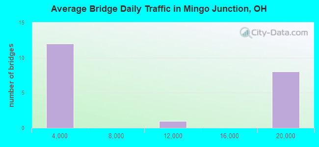
- 162,119Total average daily traffic
- 23,034Total average daily truck traffic
- National Bridge Inventory (NBI) Registered Bridges for Mingo Junction
- No street view available for this location
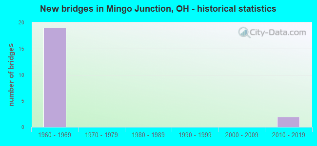
- New bridges - historical statistics
- 191960-1969
- 22010-2019
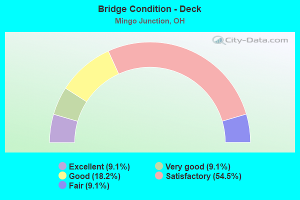
- Bridge Condition - Deck
- 9.1%Excellent
- 9.1%Very good
- 18.2%Good
- 54.5%Satisfactory
- 9.1%Fair
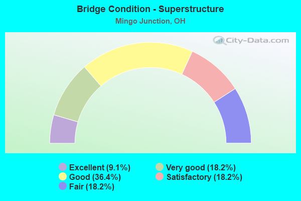
- Bridge Condition - Superstructure
- 9.1%Excellent
- 18.2%Very good
- 36.4%Good
- 18.2%Satisfactory
- 18.2%Fair
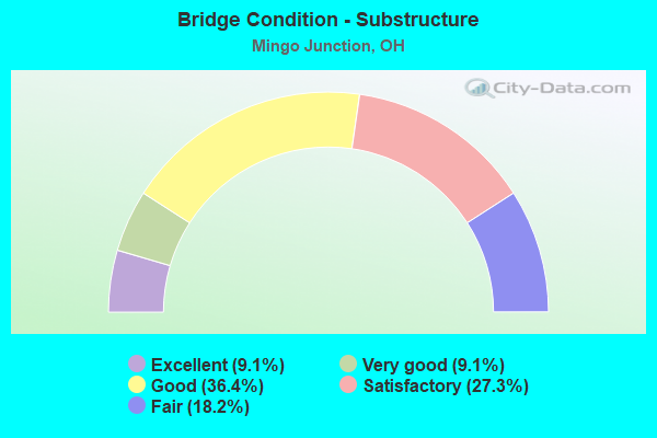
- Bridge Condition - Substructure
- 9.1%Excellent
- 9.1%Very good
- 36.4%Good
- 27.3%Satisfactory
- 18.2%Fair
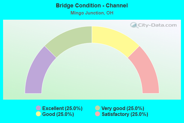
- Bridge Condition - Channel
- 25.0%Excellent
- 25.0%Very good
- 25.0%Good
- 25.0%Satisfactory
Find on map >> Show street view
Structure Number: 4100484, Location: 1.93 MI N OF CONRAIL RR (Lat: 40.300561, Lng: -80.620361), Route carried "on" structure: State highway 7, Year Built: 1960, Status: Open, Structure Length: 5.48m (17.98ft), Average Daily Traffic: 16,175 (year 2015), Truck Traffic: 15%, Average Future Daily Traffic: 22,451 (year 2035), Design Load: HS 20, Features Intersected: OVER SR 151
Minimum Vertical Clearance: 30+ m (98+ ft), Kilometerpoint: 19.071, Lanes on structure: 4, Lanes under structure: 4, Base Highway Network: Yes, Owner: State Highway Agency, Approaching Roadway Width: 20.6m (67.6ft), Skew: 31 degrees, Material/Design: Steel continuous, Design/Construction: Stringer/Multi-beam, Number Of Spans In Main Unit: 3, Length of Maximum Span: 23.5m (77.1ft), Curb or Sidewalk Widths: Left: 0.3m (1.0ft), Right: 0.3m (1.0ft), Curb-To-Curb Width: 20.6m (67.6ft), Out-to-Out Width: 22.9m (75.1ft)
Condition: Deck: Satisfactory, Superstructure: Satisfactory, Substructure: Satisfactory, Operating Rating: 32.4 metric tons, Method Used To Determine Operating Rating: Allowable Stress (AS) rating reported by rating factor (RF) method using MS18 loading, Inventory Rating: 25.9 metric tons, Method Used To Determine Inventory Rating: Allowable Stress (AS) rating reported by rating factor (RF) method using MS18 loading, Structural Evaluation: Equal to present minimum criteria, Deck Geometry: Equal to present minimum criteria, Underclear: High priority of corrective action, Approach Roadway Alignment: Equal to present desirable criteria, Designated Inspection Frequency: Every 12 months, Inspection Date: November 2021, Deck Structure Type: Concrete Cast-file-Place, Wearing Surface/Protective System: Wearing Surface: Low Slump Concrete
Find on map >> Show street view
Structure Number: 4100549, Location: .5 M N OF SR 151 (Lat: 40.307439, Lng: -80.618319), Route carried "on" structure: State highway 7, Year Built: 1960, Status: Open, Structure Length: 4.10m (13.45ft), Average Daily Traffic: 16,175 (year 2015), Truck Traffic: 15%, Average Future Daily Traffic: 22,451 (year 2035), Design Load: HS 20, Features Intersected: GLADYS AVE
Minimum Vertical Clearance: 30+ m (98+ ft), Kilometerpoint: 19.859, Lanes on structure: 4, Lanes under structure: 2, Base Highway Network: Yes, Owner: State Highway Agency, Approaching Roadway Width: 21.2m (69.6ft), Skew: 30 degrees, Material/Design: Steel continuous, Design/Construction: Stringer/Multi-beam, Number Of Spans In Main Unit: 3, Length of Maximum Span: 15.2m (49.9ft), Curb-To-Curb Width: 21.2m (69.6ft), Out-to-Out Width: 23.2m (76.1ft)
Condition: Deck: Satisfactory, Superstructure: Good, Substructure: Very good, Operating Rating: 42.1 metric tons, Method Used To Determine Operating Rating: Allowable Stress (AS) rating reported by rating factor (RF) method using MS18 loading, Inventory Rating: 32.4 metric tons, Method Used To Determine Inventory Rating: Allowable Stress (AS) rating reported by rating factor (RF) method using MS18 loading, Structural Evaluation: Better than present minimum criteria, Deck Geometry: Better than present minimum criteria, Underclear: High priority of corrective action, Approach Roadway Alignment: Equal to present desirable criteria, Designated Inspection Frequency: Every 24 months, Inspection Date: November 2021, Deck Structure Type: Concrete Cast-file-Place, Wearing Surface/Protective System: Wearing Surface: Monolithic Concrete, Deck Protection: Epoxy Coated Reinforcing
Find on map >> Show street view
Structure Number: 4100603, Location: 1.08 MI N OF SR 151 (Lat: 40.315431, Lng: -80.614581), Route carried "on" structure: State highway 7, Year Built: 1961, Year Reconstructed: 2000, Status: Open, Structure Length: 25.41m (83.37ft), Average Daily Traffic: 17,860 (year 2018), Truck Traffic: 15%, Average Future Daily Traffic: 24,790 (year 2038), Design Load: HS 20+Mod, Features Intersected: TR167-CLF ST-RR-CROSS CR
Minimum Vertical Clearance: 30+ m (98+ ft), Kilometerpoint: 20.809, Lanes on structure: 4, Lanes under structure: 4, Base Highway Network: Yes, Owner: State Highway Agency, Approaching Roadway Width: 15.4m (50.5ft), Skew: 30 degrees, Material/Design: Steel continuous, Design/Construction: Stringer/Multi-beam, Number Of Spans In Main Unit: 8, Length of Maximum Span: 45.7m (149.9ft), Curb-To-Curb Width: 18.0m (59.1ft), Out-to-Out Width: 19.8m (65.0ft)
Condition: Deck: Satisfactory, Superstructure: Good, Substructure: Good, Channel: Good, Operating Rating: 42.1 metric tons, Method Used To Determine Operating Rating: Load Factor (LF) rating reported by rating factor (RF) method using MS18 loading, Inventory Rating: 32.4 metric tons, Method Used To Determine Inventory Rating: Load Factor (LF) rating reported by rating factor (RF) method using MS18 loading, Structural Evaluation: Better than present minimum criteria, Deck Geometry: Meets minimum limits, Underclear: High priority of corrective action, Waterway Adequacy: Superior to present desirable criteria, Approach Roadway Alignment: Somewhat better than minimum adequacy, Designated Inspection Frequency: Every 12 months, Critical Feature Inspection Frequency: Every 24 months, Inspection Date: May 2021, Critical Feature Inspection Date: May 2021, Deck Structure Type: Concrete Cast-file-Place, Wearing Surface/Protective System: Wearing Surface: Monolithic Concrete, Deck Protection: Epoxy Coated Reinforcing
Find on map >> Show street view
Structure Number: 4100638, Location: 1.46 MI N OF SR 151 (Lat: 40.319711, Lng: -80.610161), Route carried "on" structure: City street CLAIR, Year Built: 1961, Status: Open, Structure Length: 2.35m (7.71ft), Average Daily Traffic: 291 (year 2015), Truck Traffic: 6%, Average Future Daily Traffic: 24,790 (year 2035), Design Load: H 15, Features Intersected: SR 7
Minimum Vertical Clearance: 30+ m (98+ ft), Kilometerpoint: 0.000, Lanes on structure: 2, Lanes under structure: 4, Owner: State Highway Agency, Approaching Roadway Width: 8.5m (27.9ft), Material/Design: Steel, Design/Construction: Stringer/Multi-beam, Number Of Spans In Main Unit: 1, Length of Maximum Span: 22.6m (74.1ft), Curb or Sidewalk Widths: Left: 1.5m (4.9ft), Right: 1.5m (4.9ft), Curb-To-Curb Width: 8.5m (27.9ft), Out-to-Out Width: 12.3m (40.4ft)
Condition: Deck: Fair, Superstructure: Good, Substructure: Satisfactory, Operating Rating: 42.1 metric tons, Method Used To Determine Operating Rating: Load Factor (LF) rating reported by rating factor (RF) method using MS18 loading, Inventory Rating: 32.4 metric tons, Method Used To Determine Inventory Rating: Load Factor (LF) rating reported by rating factor (RF) method using MS18 loading, Structural Evaluation: Equal to present minimum criteria, Deck Geometry: Equal to present minimum criteria, Underclear: High priority of corrective action, Approach Roadway Alignment: Equal to present desirable criteria, Designated Inspection Frequency: Every 12 months, Inspection Date: November 2021, Deck Structure Type: Concrete Cast-file-Place, Wearing Surface/Protective System: Wearing Surface: Integral Concrete
Find on map >> Show street view
Structure Number: 4100662, Location: 1.55 MI N OF SR 151 (Lat: 40.320750, Lng: -80.609539), Route carried "on" structure: State highway 7, Year Built: 1961, Status: Open, Structure Length: 3.71m (12.17ft), Average Daily Traffic: 17,860 (year 2015), Truck Traffic: 15%, Average Future Daily Traffic: 24,790 (year 2035), Design Load: HS 20, Features Intersected: RAVINE ST
Minimum Vertical Clearance: 30+ m (98+ ft), Kilometerpoint: 21.565, Lanes on structure: 4, Lanes under structure: 2, Base Highway Network: Yes, Owner: State Highway Agency, Approaching Roadway Width: 15.2m (49.9ft), Skew: 31 degrees, Material/Design: Steel continuous, Design/Construction: Stringer/Multi-beam, Number Of Spans In Main Unit: 3, Length of Maximum Span: 13.7m (44.9ft), Curb-To-Curb Width: 20.6m (67.6ft), Out-to-Out Width: 22.9m (75.1ft)
Condition: Deck: Satisfactory, Superstructure: Fair, Substructure: Fair, Operating Rating: 42.1 metric tons, Method Used To Determine Operating Rating: Allowable Stress (AS) rating reported by rating factor (RF) method using MS18 loading, Inventory Rating: 32.4 metric tons, Method Used To Determine Inventory Rating: Allowable Stress (AS) rating reported by rating factor (RF) method using MS18 loading, Structural Evaluation: Somewhat better than minimum adequacy, Deck Geometry: Equal to present minimum criteria, Underclear: High priority of corrective action, Approach Roadway Alignment: Equal to present desirable criteria, Designated Inspection Frequency: Every 12 months, Inspection Date: November 2021, Deck Structure Type: Concrete Cast-file-Place, Wearing Surface/Protective System: Wearing Surface: Integral Concrete
Find on map >> Show street view
Structure Number: 4100697, Location: 1.59 MI N OF SR 151 (Lat: 40.321381, Lng: -80.609061), Route carried "on" structure: City street LINCN, Year Built: 1961, Status: Open, Structure Length: 2.38m (7.81ft), Average Daily Traffic: 100 (year 1970), Average Future Daily Traffic: 24,790 (year 1990), Design Load: H 15, Features Intersected: SR 7, Facility Carried by Structure: LINCOLN AVE
Minimum Vertical Clearance: 30+ m (98+ ft), Kilometerpoint: 0.000, Lanes on structure: 2, Lanes under structure: 4, Owner: State Highway Agency, Approaching Roadway Width: 5.8m (19.0ft), Material/Design: Steel, Design/Construction: Stringer/Multi-beam, Number Of Spans In Main Unit: 1, Length of Maximum Span: 23.2m (76.1ft), Curb or Sidewalk Widths: Left: 1.5m (4.9ft), Right: 1.5m (4.9ft), Curb-To-Curb Width: 7.3m (24.0ft), Out-to-Out Width: 11.3m (37.1ft)
Condition: Deck: Good, Superstructure: Good, Substructure: Good, Operating Rating: 42.1 metric tons, Method Used To Determine Operating Rating: Load Factor (LF) rating reported by rating factor (RF) method using MS18 loading, Inventory Rating: 32.4 metric tons, Method Used To Determine Inventory Rating: Load Factor (LF) rating reported by rating factor (RF) method using MS18 loading, Structural Evaluation: Better than present minimum criteria, Deck Geometry: Equal to present minimum criteria, Underclear: High priority of corrective action, Approach Roadway Alignment: Equal to present desirable criteria, Designated Inspection Frequency: Every 24 months, Inspection Date: November 2021, Deck Structure Type: Concrete Cast-file-Place, Wearing Surface/Protective System: Wearing Surface: Integral Concrete
Find on map >> Show street view
Structure Number: 4100727, Location: 1.63 MI N OF SR 151 (Lat: 40.321781, Lng: -80.608689), Route carried "on" structure: State highway 7, Year Built: 1961, Year Reconstructed: 2014, Status: Open, Structure Length: 8.85m (29.04ft), Average Daily Traffic: 17,860 (year 2015), Truck Traffic: 15%, Average Future Daily Traffic: 24,790 (year 2035), Design Load: HS 20, Features Intersected: MCLISTER AVE
Minimum Vertical Clearance: 30+ m (98+ ft), Kilometerpoint: 21.694, Lanes on structure: 4, Lanes under structure: 2, Base Highway Network: Yes, Owner: State Highway Agency, Approaching Roadway Width: 22.6m (74.1ft), Skew: 30 degrees, Material/Design: Steel continuous, Design/Construction: Stringer/Multi-beam, Number Of Spans In Main Unit: 3, Length of Maximum Span: 33.5m (109.9ft), Curb-To-Curb Width: 20.7m (67.9ft), Out-to-Out Width: 23.6m (77.4ft)
Condition: Deck: Satisfactory, Superstructure: Very good, Substructure: Good, Operating Rating: 42.1 metric tons, Method Used To Determine Operating Rating: Allowable Stress (AS) rating reported by rating factor (RF) method using MS18 loading, Inventory Rating: 32.4 metric tons, Method Used To Determine Inventory Rating: Allowable Stress (AS) rating reported by rating factor (RF) method using MS18 loading, Structural Evaluation: Better than present minimum criteria, Deck Geometry: Equal to present minimum criteria, Underclear: High priority of corrective action, Approach Roadway Alignment: Equal to present desirable criteria, Designated Inspection Frequency: Every 12 months, Inspection Date: April 2021, Deck Structure Type: Concrete Cast-file-Place, Wearing Surface/Protective System: Wearing Surface: Integral Concrete
Find on map >> Show street view
Structure Number: 4100751, Location: 1.84 MI N OF SR 151 (Lat: 40.324261, Lng: -80.606611), Route carried "on" structure: State highway 7, Year Built: 1961, Status: Open, Structure Length: 4.51m (14.80ft), Average Daily Traffic: 18,784 (year 2015), Truck Traffic: 15%, Average Future Daily Traffic: 26,072 (year 2035), Design Load: HS 20, Features Intersected: LOGAN ST
Minimum Vertical Clearance: 30+ m (98+ ft), Kilometerpoint: 22.032, Lanes on structure: 4, Lanes under structure: 2, Base Highway Network: Yes, Owner: State Highway Agency, Approaching Roadway Width: 15.2m (49.9ft), Skew: 32 degrees, Material/Design: Steel continuous, Design/Construction: Stringer/Multi-beam, Number Of Spans In Main Unit: 3, Length of Maximum Span: 16.8m (55.1ft), Curb-To-Curb Width: 20.6m (67.6ft), Out-to-Out Width: 22.9m (75.1ft)
Condition: Deck: Good, Superstructure: Fair, Substructure: Fair, Operating Rating: 42.1 metric tons, Method Used To Determine Operating Rating: Allowable Stress (AS) rating reported by rating factor (RF) method using MS18 loading, Inventory Rating: 32.4 metric tons, Method Used To Determine Inventory Rating: Allowable Stress (AS) rating reported by rating factor (RF) method using MS18 loading, Structural Evaluation: Somewhat better than minimum adequacy, Deck Geometry: Equal to present minimum criteria, Underclear: High priority of corrective action, Approach Roadway Alignment: Equal to present desirable criteria, Designated Inspection Frequency: Every 12 months, Inspection Date: October 2021, Deck Structure Type: Concrete Cast-file-Place, Wearing Surface/Protective System: Wearing Surface: Integral Concrete
Find on map >> Show street view
Structure Number: 4100786, Location: 2.05 MI N OF SR 151 (Lat: 40.327289, Lng: -80.605581), Route carried "on" structure: State highway 7, Year Built: 1961, Status: Open, Structure Length: 7.25m (23.79ft), Average Daily Traffic: 9,392 (year 2015), Truck Traffic: 15%, Average Future Daily Traffic: 13,036 (year 2035), Design Load: HS 20, Features Intersected: SIDE HILL STRUCTURE NB7
Minimum Vertical Clearance: 30+ m (98+ ft), Kilometerpoint: 22.370, Lanes on structure: 2, Base Highway Network: Yes, Owner: State Highway Agency, Approaching Roadway Width: 21.3m (69.9ft), Material/Design: Concrete continuous, Design/Construction: Slab, Number Of Spans In Main Unit: 7, Length of Maximum Span: 12.2m (40.0ft), Curb-To-Curb Width: 18.0m (59.1ft), Out-to-Out Width: 18.1m (59.4ft)
Condition: Deck: Satisfactory, Superstructure: Satisfactory, Substructure: Satisfactory, Operating Rating: 42.1 metric tons, Method Used To Determine Operating Rating: Load Factor (LF) rating reported by rating factor (RF) method using MS18 loading, Inventory Rating: 32.4 metric tons, Method Used To Determine Inventory Rating: Load Factor (LF) rating reported by rating factor (RF) method using MS18 loading, Structural Evaluation: Equal to present minimum criteria, Deck Geometry: Superior to present desirable criteria, Waterway Adequacy: Superior to present desirable criteria, Approach Roadway Alignment: Somewhat better than minimum adequacy, Designated Inspection Frequency: Every 12 months, Inspection Date: October 2021, Deck Structure Type: Concrete Cast-file-Place, Wearing Surface/Protective System: Wearing Surface: Bituminous
Find on map >> Show street view
Structure Number: 4102584, Location: .33 MI W OF SR 7 (Lat: 40.300631, Lng: -80.625231), Route carried "on" structure: State highway 151, Year Built: 1960, Status: Open, Structure Length: 0.70m (2.30ft), Average Daily Traffic: 2,641 (year 2015), Truck Traffic: 5%, Average Future Daily Traffic: 3,666 (year 2035), Design Load: H 15, Features Intersected: GEORGES RUN
Minimum Vertical Clearance: 30+ m (98+ ft), Kilometerpoint: 25.428, Lanes on structure: 3, Owner: State Highway Agency, Approaching Roadway Width: 16.8m (55.1ft), Skew: 4 degrees, Material/Design: Steel, Design/Construction: Culvert, Number Of Spans In Main Unit: 1, Length of Maximum Span: 7.0m (23.0ft)
Condition: Channel: Satisfactory, Culverts: Satisfactory, Operating Rating: 42.1 metric tons, Method Used To Determine Operating Rating: Load Factor (LF) rating reported by rating factor (RF) method using MS18 loading, Inventory Rating: 32.4 metric tons, Method Used To Determine Inventory Rating: Load Factor (LF) rating reported by rating factor (RF) method using MS18 loading, Structural Evaluation: Equal to present minimum criteria, Waterway Adequacy: Equal to present desirable criteria, Approach Roadway Alignment: Equal to present desirable criteria, Length Of Structure Improvement: 0.70m (2.30ft), Designated Inspection Frequency: Every 12 months, Inspection Date: October 2021, Roadway Improvement Cost: $3,000, Total Project Cost: $125,000
Find on map >> Show street view
Structure Number: 4131925, Location: 200-ft NE of SR151 (Lat: 40.301119, Lng: -80.618350), Route carried "on" structure: County highway C007B, Year Built: 2019, Status: Open, Structure Length: 0.79m (2.59ft), Average Daily Traffic: 510 (year 2016), Truck Traffic: 5%, Average Future Daily Traffic: 612 (year 2040), Design Load: HL 93, Features Intersected: George's Run
Minimum Vertical Clearance: 30+ m (98+ ft), Kilometerpoint: 0.563, Lanes on structure: 2, Owner: County Highway Agency, Approaching Roadway Width: 11.0m (36.1ft), Skew: 2 degrees, Material/Design: Concrete, Design/Construction: Slab, Number Of Spans In Main Unit: 1, Length of Maximum Span: 6.6m (21.7ft), Curb or Sidewalk Widths: Left: 1.4m (4.6ft), Right: 1.4m (4.6ft), Curb-To-Curb Width: 11.0m (36.1ft), Out-to-Out Width: 15.4m (50.5ft)
Condition: Deck: Excellent, Superstructure: Excellent, Substructure: Excellent, Channel: Excellent, Operating Rating: 54.4 metric tons, Method Used To Determine Operating Rating: Load and Resistance Factor Rating (LRFR) rating reported by rating factor(RF) method using HL-93 loadings, Inventory Rating: 32.7 metric tons, Method Used To Determine Inventory Rating: Load and Resistance Factor Rating (LRFR) rating reported by rating factor(RF) method using HL-93 loadings, Structural Evaluation: Superior to present desirable criteria, Deck Geometry: Better than present minimum criteria, Waterway Adequacy: Superior to present desirable criteria, Approach Roadway Alignment: Equal to present desirable criteria, Length Of Structure Improvement: 0.76m (2.49ft), Designated Inspection Frequency: Every 12 months, Inspection Date: April 2021, Bridge Improvement Cost: $490,000,000, Total Project Cost: $490,000,000, Deck Structure Type: Concrete Cast-file-Place, Wearing Surface/Protective System: Wearing Surface: Monolithic Concrete, Membrane: Epoxy, Deck Protection: Epoxy Coated Reinforcing
Find on map >> Show street view
Structure Number: 4161378, Location: .03MI N. OF SR7 RAMP (Lat: 40.316000, Lng: -80.613269), Route carried "on" structure: Business City street COMAV, Year Built: 2011, Status: Open, Structure Length: 3.63m (11.91ft), Average Daily Traffic: 990 (year 2015), Truck Traffic: 7%, Average Future Daily Traffic: 1,374 (year 2035), Design Load: HL 93, Features Intersected: CROSS CREEK, Facility Carried by Structure: COMMERCIAL AVE
Minimum Vertical Clearance: 30+ m (98+ ft), Kilometerpoint: 0.048, Lanes on structure: 2, Owner: City or Municipal Highway Agency, Approaching Roadway Width: 12.8m (42.0ft), Material/Design: Concrete continuous, Design/Construction: Slab, Number Of Spans In Main Unit: 3, Length of Maximum Span: 14.0m (45.9ft), Curb or Sidewalk Widths: Left: 0.0m, Right: 1.5m (4.9ft), Curb-To-Curb Width: 9.1m (29.9ft), Out-to-Out Width: 11.3m (37.1ft)
Condition: Deck: Very good, Superstructure: Very good, Substructure: Good, Channel: Very good, Operating Rating: 45.4 metric tons, Method Used To Determine Operating Rating: Load and Resistance Factor Rating (LRFR) rating reported by rating factor(RF) method using HL-93 loadings, Inventory Rating: 35.6 metric tons, Method Used To Determine Inventory Rating: Load and Resistance Factor Rating (LRFR) rating reported by rating factor(RF) method using HL-93 loadings, Structural Evaluation: Better than present minimum criteria, Deck Geometry: Equal to present minimum criteria, Waterway Adequacy: Somewhat better than minimum adequacy, Approach Roadway Alignment: Equal to present desirable criteria, Designated Inspection Frequency: Every 24 months, Inspection Date: August 2021, Deck Structure Type: Concrete Cast-file-Place, Wearing Surface/Protective System: Wearing Surface: Bituminous, Deck Protection: Epoxy Coated Reinforcing
Find on map >> Show street view
Structure Number: 4100484, Location: 1.93 MI N OF CONRAIL RR (Lat: 40.300561, Lng: -80.620361), Route carried "under" structure: State highway 151, Year Built: 1960, Structure Length: 0. m, Average Daily Traffic: 2,028 (year 2015), Truck Traffic: 5%, Features Intersected: SR 7, Facility Carried by Structure: SR 7
Minimum Vertical Clearance: 7.09m (23.26ft), Kilometerpoint: 25.959, Lanes on structure: 4, Lanes under structure: 4, Material/Design: Steel continuous, Design/Construction: Stringer/Multi-beam, Length of Maximum Span: 23.5m (77.1ft)
Find on map >> Show street view
Structure Number: 4100549, Location: .5 M N OF SR 151 (Lat: 40.307439, Lng: -80.618319), Route carried "under" structure: City street GLADY, Year Built: 1960, Structure Length: 0. m, Average Daily Traffic: 100 (year 1970), Features Intersected: SR 7, Facility Carried by Structure: SR 7
Minimum Vertical Clearance: 4.36m (14.30ft), Kilometerpoint: 0.000, Lanes on structure: 4, Lanes under structure: 2, Material/Design: Steel continuous, Design/Construction: Stringer/Multi-beam, Length of Maximum Span: 15.2m (49.9ft)
Find on map >> Show street view
Structure Number: 4100603, Location: 1.08 MI N OF SR 151 (Lat: 40.315431, Lng: -80.614581), Route carried "under" structure: County highway 167A, Year Built: 1961, Structure Length: 0. m, Average Daily Traffic: 1,747 (year 2015), Truck Traffic: 7%, Features Intersected: SR 7, Facility Carried by Structure: SR7
Minimum Vertical Clearance: 6.88m (22.57ft), Kilometerpoint: 0.805, Lanes on structure: 4, Lanes under structure: 4, Material/Design: Steel continuous, Design/Construction: Stringer/Multi-beam, Length of Maximum Span: 45.7m (149.9ft)
Find on map >> Show street view
Structure Number: 4100603, Location: 1.08 MI N OF SR 151 (Lat: 40.315431, Lng: -80.614581), Route carried "under" structure: City street 74, Year Built: 1961, Structure Length: 0. m, Average Daily Traffic: 900 (year 1972), Features Intersected: SR 7, Facility Carried by Structure: SR7
Minimum Vertical Clearance: 6.88m (22.57ft), Kilometerpoint: 4.828, Lanes on structure: 4, Lanes under structure: 4, Material/Design: Steel continuous, Design/Construction: Stringer/Multi-beam, Length of Maximum Span: 45.7m (149.9ft)
Find on map >> Show street view
Structure Number: 4100638, Location: 1.46 MI N OF SR 151 (Lat: 40.319711, Lng: -80.610161), Route carried "under" structure: State highway 7, Year Built: 1961, Structure Length: 0. m, Average Daily Traffic: 17,860 (year 2015), Truck Traffic: 15%, Features Intersected: ST.CLAIR AVE(SUBWAY), Facility Carried by Structure: ST CLAIRE AVE
Minimum Vertical Clearance: 5.01m (16.44ft), Kilometerpoint: 21.420, Lanes on structure: 2, Lanes under structure: 4, Material/Design: Steel, Design/Construction: Stringer/Multi-beam, Length of Maximum Span: 22.6m (74.1ft)
Find on map >> Show street view
Structure Number: 4100662, Location: 1.55 MI N OF SR 151 (Lat: 40.320750, Lng: -80.609539), Route carried "under" structure: City street RAVIN, Year Built: 1961, Structure Length: 0. m, Average Daily Traffic: 100 (year 1970), Features Intersected: SR 7, Facility Carried by Structure: SR 7
Minimum Vertical Clearance: 5.31m (17.42ft), Kilometerpoint: 0.000, Lanes on structure: 4, Lanes under structure: 2, Material/Design: Steel continuous, Design/Construction: Stringer/Multi-beam, Length of Maximum Span: 13.7m (44.9ft)
Find on map >> Show street view
Structure Number: 4100697, Location: 1.59 MI N OF SR 151 (Lat: 40.321381, Lng: -80.609061), Route carried "under" structure: State highway 7, Year Built: 1961, Structure Length: 0. m, Average Daily Traffic: 17,860 (year 2015), Truck Traffic: 15%, Features Intersected: LINCOLN AVE(SUBWAY), Facility Carried by Structure: LINCOLN AVE
Minimum Vertical Clearance: 5.05m (16.57ft), Kilometerpoint: 21.630, Lanes on structure: 2, Lanes under structure: 4, Material/Design: Steel, Design/Construction: Stringer/Multi-beam, Length of Maximum Span: 23.2m (76.1ft)
Find on map >> Show street view
Structure Number: 4100727, Location: 1.63 MI N OF SR 151 (Lat: 40.321781, Lng: -80.608689), Route carried "under" structure: City street MCLSR, Year Built: 1961, Structure Length: 0. m, Average Daily Traffic: 1,028 (year 2015), Truck Traffic: 4%, Features Intersected: SR 7, Facility Carried by Structure: SR 7
Minimum Vertical Clearance: 4.42m (14.50ft), Kilometerpoint: 0.000, Lanes on structure: 4, Lanes under structure: 2, Material/Design: Steel continuous, Design/Construction: Stringer/Multi-beam, Length of Maximum Span: 33.5m (109.9ft)
Find on map >> Show street view
Structure Number: 4100751, Location: 1.84 MI N OF SR 151 (Lat: 40.324261, Lng: -80.606611), Route carried "under" structure: City street LOGAN, Year Built: 1961, Structure Length: 0. m, Average Daily Traffic: 1,858 (year 2015), Truck Traffic: 3%, Features Intersected: SR 7, Facility Carried by Structure: SR 7
Minimum Vertical Clearance: 4.67m (15.32ft), Kilometerpoint: 0.000, Lanes on structure: 4, Lanes under structure: 2, Material/Design: Steel continuous, Design/Construction: Stringer/Multi-beam, Length of Maximum Span: 16.8m (55.1ft)