Bridge Statistics for Monrovia, California (CA)
Condition, Traffic, Stress, Structural Evaluation, Project Costs
- National Bridge Inventory (NBI) Statistics
- 27Number of bridges
- 226ft / 68.5mTotal length
- 2,552,805Total average daily traffic
- 194,341Total average daily truck traffic
- National Bridge Inventory (NBI) Registered Bridges for Monrovia
- No street view available for this location
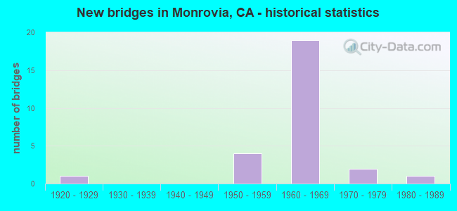
- New bridges - historical statistics
- 11920-1929
- 41950-1959
- 191960-1969
- 21970-1979
- 11980-1989
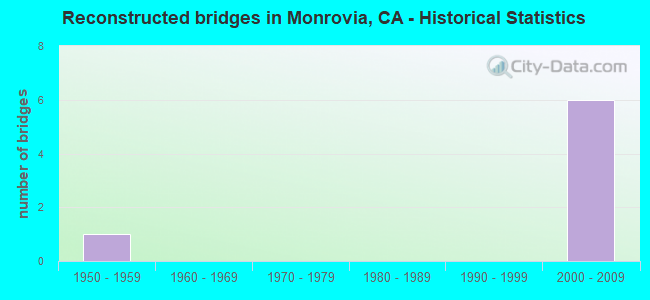
- Reconstructed bridges - Historical Statistics
- 11950-1959
- 01960-1969
- 01970-1979
- 01980-1989
- 01990-1999
- 62000-2009
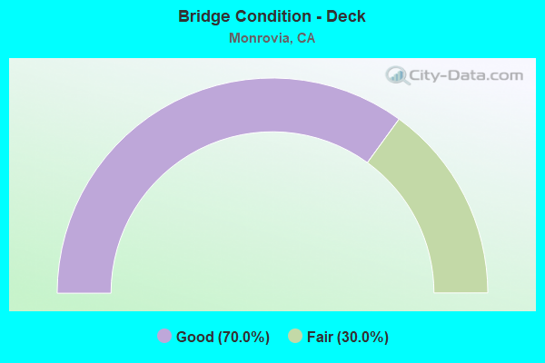
- Bridge Condition - Deck
- 70.0%Good
- 30.0%Fair
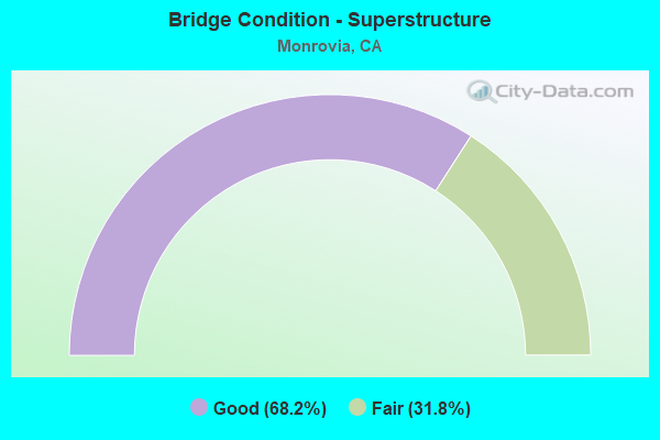
- Bridge Condition - Superstructure
- 68.2%Good
- 31.8%Fair
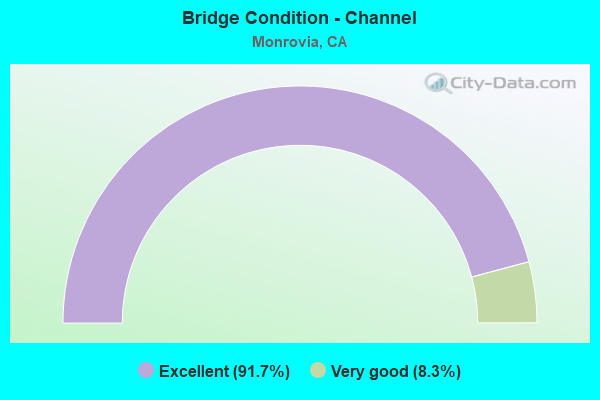
- Bridge Condition - Channel
- 91.7%Excellent
- 8.3%Very good
Find on map >> Show street view
Structure Number: 53 1810L, Location: 07-LA-005-R65.97 (Lat: 34.569492, Lng: -118.687783), Route carried "on" structure: Interstate 5, Year Built: 1967, Status: Open, Structure Length: 4.60m (15.09ft), Average Daily Traffic: 36,843 (year 2011), Truck Traffic: 29%, Average Future Daily Traffic: 62,658 (year 2039), Design Load: HS 20, Features Intersected: TEMPLIN HWY
Minimum Vertical Clearance: 30+ m (98+ ft), Kilometerpoint: 65.970, Lanes on structure: 4, Lanes under structure: 4, Base Highway Network: Yes (, Subroute: 1), Owner: State Highway Agency, Approaching Roadway Width: 20.1m (65.9ft), Material/Design: Concrete continuous, Design/Construction: Box Beam or Girders - Multiple, Number Of Spans In Main Unit: 3, Length of Maximum Span: 21.0m (68.9ft), Curb-To-Curb Width: 20.1m (65.9ft), Out-to-Out Width: 20.7m (67.9ft)
Condition: Deck: Good, Superstructure: Good, Substructure: Good, Operating Rating: 27.2 metric tons, Method Used To Determine Operating Rating: Load and Resistance Factor Rating (LRFR) rating reported by rating factor(RF) method using HL-93 loadings, Inventory Rating: 21.1 metric tons, Method Used To Determine Inventory Rating: Load and Resistance Factor Rating (LRFR) rating reported by rating factor(RF) method using HL-93 loadings, Structural Evaluation: Somewhat better than minimum adequacy, Deck Geometry: Equal to present minimum criteria, Underclear: High priority of corrective action, Approach Roadway Alignment: Somewhat better than minimum adequacy, Designated Inspection Frequency: Every 24 months, Inspection Date: June 2021, Deck Structure Type: Concrete Cast-file-Place, Wearing Surface/Protective System: Wearing Surface: Integral Concrete
Find on map >> Show street view
Structure Number: 53 1817, Location: 07-LA-210-R33.67-MNRO (Lat: 34.135272, Lng: -118.005253), Route carried "on" structure: Interstate 210, Year Built: 1966, Year Reconstructed: 2011, Status: Open, Structure Length: 1.90m (6.23ft), Average Daily Traffic: 258,000 (year 2012), Truck Traffic: 8%, Average Future Daily Traffic: 278,330 (year 2042), Design Load: HS 20, Features Intersected: MAGNOLIA AVENUE
Minimum Vertical Clearance: 30+ m (98+ ft), Kilometerpoint: 33.670, Lanes on structure: 12, Lanes under structure: 2, Base Highway Network: Yes (Inventory Route: 2, Subroute: 1), Owner: State Highway Agency, Approaching Roadway Width: 51.6m (169.3ft), Skew: 30 degrees, Material/Design: Concrete, Design/Construction: Box Beam or Girders - Multiple, Number Of Spans In Main Unit: 1, Length of Maximum Span: 18.3m (60.0ft), Curb-To-Curb Width: 51.6m (169.3ft), Out-to-Out Width: 52.6m (172.6ft)
Condition: Deck: Good, Superstructure: Good, Substructure: Good, Operating Rating: 54.1 metric tons, Method Used To Determine Operating Rating: Assigned rating based on Load Factor Design (LFD) reported in metric tons, Inventory Rating: 32.4 metric tons, Method Used To Determine Inventory Rating: Assigned rating based on Load Factor Design (LFD) reported in metric tons, Structural Evaluation: Better than present minimum criteria, Deck Geometry: Better than present minimum criteria, Underclear: Better than present minimum criteria, Approach Roadway Alignment: Superior to present desirable criteria, Designated Inspection Frequency: Every 24 months, Inspection Date: April 2021, Deck Structure Type: Concrete Cast-file-Place
Find on map >> Show street view
Structure Number: 53 1818, Location: 07-LA-210-R33.91-MNRO (Lat: 34.135283, Lng: -118.000981), Route carried "on" structure: Interstate 210, Year Built: 1966, Year Reconstructed: 2011, Status: Open, Structure Length: 2.79m (9.15ft), Average Daily Traffic: 258,000 (year 2012), Truck Traffic: 8%, Average Future Daily Traffic: 278,330 (year 2042), Design Load: HS 20, Features Intersected: MYRTLE AVENUE
Minimum Vertical Clearance: 30+ m (98+ ft), Kilometerpoint: 33.910, Lanes on structure: 10, Lanes under structure: 6, Base Highway Network: Yes (Inventory Route: 2, Subroute: 1), Owner: State Highway Agency, Approaching Roadway Width: 45.5m (149.3ft), Skew: 30 degrees, Material/Design: Concrete, Design/Construction: Box Beam or Girders - Multiple, Number Of Spans In Main Unit: 1, Length of Maximum Span: 27.4m (89.9ft), Curb-To-Curb Width: 45.5m (149.3ft), Out-to-Out Width: 46.5m (152.6ft)
Condition: Deck: Fair, Superstructure: Fair, Substructure: Good, Operating Rating: 54.1 metric tons, Method Used To Determine Operating Rating: Assigned rating based on Load Factor Design (LFD) reported in metric tons, Inventory Rating: 32.4 metric tons, Method Used To Determine Inventory Rating: Assigned rating based on Load Factor Design (LFD) reported in metric tons, Structural Evaluation: Somewhat better than minimum adequacy, Deck Geometry: Superior to present desirable criteria, Underclear: Meets minimum limits, Approach Roadway Alignment: Equal to present desirable criteria, Designated Inspection Frequency: Every 24 months, Inspection Date: April 2021, Deck Structure Type: Concrete Cast-file-Place
Find on map >> Show street view
Structure Number: 53 1819, Location: 07-LA-210-R34.24-MNRO (Lat: 34.135247, Lng: -117.995200), Route carried "on" structure: Interstate 210, Year Built: 1966, Year Reconstructed: 2011, Status: Open, Structure Length: 2.51m (8.23ft), Average Daily Traffic: 258,000 (year 2012), Truck Traffic: 8%, Average Future Daily Traffic: 278,330 (year 2042), Design Load: HS 20, Features Intersected: CALIFORNIA AVENUE
Minimum Vertical Clearance: 30+ m (98+ ft), Kilometerpoint: 34.240, Lanes on structure: 12, Lanes under structure: 6, Base Highway Network: Yes (Inventory Route: 2, Subroute: 1), Owner: State Highway Agency, Approaching Roadway Width: 50.0m (164.0ft), Skew: 30 degrees, Material/Design: Concrete, Design/Construction: Box Beam or Girders - Multiple, Number Of Spans In Main Unit: 1, Length of Maximum Span: 24.7m (81.0ft), Curb-To-Curb Width: 50.0m (164.0ft), Out-to-Out Width: 52.0m (170.6ft)
Condition: Deck: Fair, Superstructure: Fair, Substructure: Good, Operating Rating: 47.0 metric tons, Method Used To Determine Operating Rating: Load and Resistance Factor Rating (LRFR) rating reported by rating factor(RF) method using HL-93 loadings, Inventory Rating: 36.3 metric tons, Method Used To Determine Inventory Rating: Load and Resistance Factor Rating (LRFR) rating reported by rating factor(RF) method using HL-93 loadings, Structural Evaluation: Somewhat better than minimum adequacy, Deck Geometry: Equal to present minimum criteria, Underclear: Meets minimum limits, Approach Roadway Alignment: Equal to present desirable criteria, Designated Inspection Frequency: Every 24 months, Inspection Date: April 2021, Deck Structure Type: Concrete Cast-file-Place
Find on map >> Show street view
Structure Number: 53 1821, Location: 07-LA-210-R34.74-MNRO (Lat: 34.135264, Lng: -117.986500), Route carried "on" structure: Interstate 210, Year Built: 1966, Status: Open, Structure Length: 2.79m (9.15ft), Average Daily Traffic: 258,000 (year 2012), Truck Traffic: 8%, Average Future Daily Traffic: 278,330 (year 2043), Design Load: HS 20, Features Intersected: MOUNTAIN AVENUE
Minimum Vertical Clearance: 30+ m (98+ ft), Kilometerpoint: 34.740, Lanes on structure: 10, Lanes under structure: 6, Base Highway Network: Yes (Inventory Route: 2, Subroute: 1), Owner: State Highway Agency, Approaching Roadway Width: 44.8m (147.0ft), Skew: 20 degrees, Material/Design: Concrete, Design/Construction: Box Beam or Girders - Multiple, Number Of Spans In Main Unit: 1, Length of Maximum Span: 27.1m (88.9ft), Curb-To-Curb Width: 45.4m (149.0ft), Out-to-Out Width: 46.9m (153.9ft)
Condition: Deck: Good, Superstructure: Fair, Substructure: Good, Operating Rating: 39.9 metric tons, Method Used To Determine Operating Rating: Load and Resistance Factor Rating (LRFR) rating reported by rating factor(RF) method using HL-93 loadings, Inventory Rating: 30.8 metric tons, Method Used To Determine Inventory Rating: Load and Resistance Factor Rating (LRFR) rating reported by rating factor(RF) method using HL-93 loadings, Structural Evaluation: Somewhat better than minimum adequacy, Deck Geometry: Superior to present desirable criteria, Underclear: Meets minimum limits, Approach Roadway Alignment: Superior to present desirable criteria, Designated Inspection Frequency: Every 24 months, Inspection Date: April 2021, Deck Structure Type: Concrete Cast-file-Place
Find on map >> Show street view
Structure Number: 53 186, Location: 07-LA-014-R70.99-LAN (Lat: 34.733167, Lng: -118.170722), Route carried "on" structure: City street W499, Year Built: 1968, Status: Open, Structure Length: 7.74m (25.39ft), Average Daily Traffic: 1,450 (year 2017), Truck Traffic: 2%, Average Future Daily Traffic: 1,934 (year 2041), Design Load: HS 20, Features Intersected: ROUTE 14, Facility Carried by Structure: AVENUE "G"
Minimum Vertical Clearance: 30+ m (98+ ft), Kilometerpoint: 0.000, Lanes on structure: 2, Lanes under structure: 6, Owner: State Highway Agency, Approaching Roadway Width: 9.8m (32.2ft), Material/Design: Concrete continuous, Design/Construction: Box Beam or Girders - Multiple, Number Of Spans In Main Unit: 2, Length of Maximum Span: 38.4m (126.0ft), Curb or Sidewalk Widths: Left: 0.0m, Right: 1.7m (5.6ft), Curb-To-Curb Width: 9.8m (32.2ft), Out-to-Out Width: 12.1m (39.7ft)
Condition: Deck: Good, Superstructure: Good, Substructure: Good, Operating Rating: 52.8 metric tons, Method Used To Determine Operating Rating: Load and Resistance Factor Rating (LRFR) rating reported by rating factor(RF) method using HL-93 loadings, Inventory Rating: 40.8 metric tons, Method Used To Determine Inventory Rating: Load and Resistance Factor Rating (LRFR) rating reported by rating factor(RF) method using HL-93 loadings, Structural Evaluation: Better than present minimum criteria, Deck Geometry: Somewhat better than minimum adequacy, Underclear: Equal to present minimum criteria, Approach Roadway Alignment: Superior to present desirable criteria, Designated Inspection Frequency: Every 24 months, Inspection Date: May 2021, Deck Structure Type: Concrete Cast-file-Place
Find on map >> Show street view
Structure Number: 53 1869, Location: 07-LA-210-R32.89-MNRO (Lat: 34.140481, Lng: -118.017222), Route carried "on" structure: Interstate 210, Year Built: 1967, Status: Open, Structure Length: 6.91m (22.67ft), Average Daily Traffic: 252,000 (year 2012), Truck Traffic: 7%, Average Future Daily Traffic: 270,961 (year 2043), Design Load: HS 20, Features Intersected: HUNTINGTON DRIVE
Minimum Vertical Clearance: 30+ m (98+ ft), Kilometerpoint: 32.890, Lanes on structure: 12, Lanes under structure: 7, Base Highway Network: Yes (Inventory Route: 2, Subroute: 1), Owner: State Highway Agency, Approaching Roadway Width: 52.1m (170.9ft), Skew: 33 degrees, Material/Design: Concrete continuous, Design/Construction: Box Beam or Girders - Multiple, Number Of Spans In Main Unit: 3, Length of Maximum Span: 41.1m (134.8ft), Curb-To-Curb Width: 53.0m (173.9ft), Out-to-Out Width: 55.4m (181.8ft)
Condition: Deck: Good, Superstructure: Good, Substructure: Good, Operating Rating: 80.0 metric tons, Method Used To Determine Operating Rating: Load Factor (LF), Inventory Rating: 48.0 metric tons, Method Used To Determine Inventory Rating: Load Factor (LF), Structural Evaluation: Better than present minimum criteria, Deck Geometry: Superior to present desirable criteria, Underclear: High priority of corrective action, Approach Roadway Alignment: Superior to present desirable criteria, Designated Inspection Frequency: Every 24 months, Inspection Date: April 2021, Deck Structure Type: Concrete Cast-file-Place
Find on map >> Show street view
Structure Number: 53 1872, Location: 07-LA-210-R33.10-MNRO (Lat: 34.137892, Lng: -118.014436), Route carried "on" structure: Interstate 210, Year Built: 1967, Year Reconstructed: 2011, Status: Open, Structure Length: 5.19m (17.03ft), Average Daily Traffic: 258,000 (year 2012), Truck Traffic: 8%, Average Future Daily Traffic: 278,330 (year 2043), Design Load: HS 20, Features Intersected: MONTEREY AVENUE
Minimum Vertical Clearance: 30+ m (98+ ft), Kilometerpoint: 33.100, Lanes on structure: 11, Lanes under structure: 2, Base Highway Network: Yes (Inventory Route: 2, Subroute: 1), Owner: State Highway Agency, Approaching Roadway Width: 46.9m (153.9ft), Skew: 33 degrees, Material/Design: Concrete continuous, Design/Construction: Box Beam or Girders - Multiple, Number Of Spans In Main Unit: 3, Length of Maximum Span: 23.8m (78.1ft), Curb-To-Curb Width: 46.9m (153.9ft), Out-to-Out Width: 50.1m (164.4ft)
Condition: Deck: Good, Superstructure: Good, Substructure: Good, Operating Rating: 54.1 metric tons, Method Used To Determine Operating Rating: Assigned rating based on Load Factor Design (LFD) reported in metric tons, Inventory Rating: 32.4 metric tons, Method Used To Determine Inventory Rating: Assigned rating based on Load Factor Design (LFD) reported in metric tons, Structural Evaluation: Better than present minimum criteria, Deck Geometry: Better than present minimum criteria, Underclear: Equal to present minimum criteria, Approach Roadway Alignment: Superior to present desirable criteria, Designated Inspection Frequency: Every 24 months, Inspection Date: April 2021, Deck Structure Type: Concrete Cast-file-Place
Find on map >> Show street view
Structure Number: 53 1874, Location: 07-LA-210-R34.60-MNRO (Lat: 34.135267, Lng: -117.988911), Route carried "on" structure: Interstate 210, Year Built: 1967, Status: Open, Structure Length: 1.07m (3.51ft), Average Daily Traffic: 258,000 (year 2012), Truck Traffic: 8%, Average Future Daily Traffic: 278,330 (year 2042), Design Load: HS 20, Features Intersected: SAWPIT WASH
Minimum Vertical Clearance: 30+ m (98+ ft), Kilometerpoint: 34.600, Lanes on structure: 14, Base Highway Network: Yes (Inventory Route: 2, Subroute: 1), Owner: State Highway Agency, Approaching Roadway Width: 44.5m (146.0ft), Skew: 20 degrees, Material/Design: Concrete, Design/Construction: Frame, Number Of Spans In Main Unit: 1, Length of Maximum Span: 10.1m (33.1ft), Curb or Sidewalk Widths: Left: 2.7m (8.9ft), Right: 2.1m (6.9ft), Curb-To-Curb Width: 45.5m (149.3ft), Out-to-Out Width: 83.0m (272.3ft)
Condition: Deck: Good, Superstructure: Good, Substructure: Good, Channel: Very good, Operating Rating: 99.8 metric tons, Method Used To Determine Operating Rating: Load Factor (LF), Inventory Rating: 99.8 metric tons, Method Used To Determine Inventory Rating: Load Factor (LF), Structural Evaluation: Better than present minimum criteria, Deck Geometry: High priority of replacement, Waterway Adequacy: Equal to present desirable criteria, Approach Roadway Alignment: Superior to present desirable criteria, Designated Inspection Frequency: Every 24 months, Inspection Date: April 2021
Find on map >> Show street view
Structure Number: 53 1882, Location: 07-LA-210-R32.61-MNRO (Lat: 34.142644, Lng: -118.020822), Route carried "on" structure: Interstate 210, Year Built: 1968, Year Reconstructed: 2011, Status: Open, Structure Length: 14.76m (48.43ft), Average Daily Traffic: 252,000 (year 2012), Truck Traffic: 7%, Average Future Daily Traffic: 267,378 (year 2043), Design Load: HS 20, Features Intersected: FIFTH AVENUE
Minimum Vertical Clearance: 30+ m (98+ ft), Kilometerpoint: 32.610, Lanes on structure: 12, Lanes under structure: 6, Base Highway Network: Yes (Inventory Route: 2, Subroute: 1), Owner: State Highway Agency, Approaching Roadway Width: 47.5m (155.8ft), Skew: 33 degrees, Material/Design: Concrete continuous, Design/Construction: Box Beam or Girders - Multiple, Number Of Spans In Main Unit: 6, Length of Maximum Span: 38.4m (126.0ft), Curb-To-Curb Width: 45.7m (149.9ft), Out-to-Out Width: 54.0m (177.2ft)
Condition: Deck: Good, Superstructure: Fair, Substructure: Good, Operating Rating: 54.1 metric tons, Method Used To Determine Operating Rating: Assigned rating based on Load Factor Design (LFD) reported in metric tons, Inventory Rating: 32.4 metric tons, Method Used To Determine Inventory Rating: Assigned rating based on Load Factor Design (LFD) reported in metric tons, Structural Evaluation: Somewhat better than minimum adequacy, Deck Geometry: Meets minimum limits, Underclear: Equal to present minimum criteria, Approach Roadway Alignment: Superior to present desirable criteria, Designated Inspection Frequency: Every 24 months, Inspection Date: April 2021, Deck Structure Type: Concrete Cast-file-Place
Find on map >> Show street view
Structure Number: 53 1883, Location: 07-LA-210-R33.40-MNRO (Lat: 34.136164, Lng: -118.009772), Route carried "on" structure: Interstate 210, Year Built: 1967, Year Reconstructed: 2011, Status: Open, Structure Length: 4.65m (15.26ft), Average Daily Traffic: 258,000 (year 2012), Truck Traffic: 8%, Average Future Daily Traffic: 278,330 (year 2043), Design Load: HS 20, Features Intersected: MAYFLOWER AVENUE
Minimum Vertical Clearance: 30+ m (98+ ft), Kilometerpoint: 33.400, Lanes on structure: 10, Lanes under structure: 2, Base Highway Network: Yes (Inventory Route: 2, Subroute: 1), Owner: State Highway Agency, Approaching Roadway Width: 43.9m (144.0ft), Skew: 32 degrees, Material/Design: Concrete continuous, Design/Construction: Box Beam or Girders - Multiple, Number Of Spans In Main Unit: 3, Length of Maximum Span: 26.8m (87.9ft), Curb-To-Curb Width: 43.9m (144.0ft), Out-to-Out Width: 48.3m (158.5ft)
Condition: Deck: Good, Superstructure: Good, Substructure: Good, Operating Rating: 54.1 metric tons, Method Used To Determine Operating Rating: Assigned rating based on Load Factor Design (LFD) reported in metric tons, Inventory Rating: 32.4 metric tons, Method Used To Determine Inventory Rating: Assigned rating based on Load Factor Design (LFD) reported in metric tons, Structural Evaluation: Better than present minimum criteria, Deck Geometry: Better than present minimum criteria, Underclear: Somewhat better than minimum adequacy, Approach Roadway Alignment: Superior to present desirable criteria, Designated Inspection Frequency: Every 24 months, Inspection Date: April 2021, Deck Structure Type: Concrete Cast-file-Place
Find on map >> Show street view
Structure Number: 53C0409, Location: 0.2MI N/O HUNTINGTON DR (Lat: 34.143392, Lng: -117.986167), Route carried "on" structure: City street Q498, Year Built: 1956, Status: Open, Structure Length: 1.68m (5.51ft), Average Daily Traffic: 17,582 (year 2016), Truck Traffic: 1%, Average Future Daily Traffic: 21,098 (year 2038), Design Load: HS 20, Features Intersected: SAWPIT WASH, Facility Carried by Structure: MTN AVE
Minimum Vertical Clearance: 30.47m (99.97ft), Kilometerpoint: 0.000, Lanes on structure: 6, Owner: City or Municipal Highway Agency, Approaching Roadway Width: 11.0m (36.1ft), Skew: 36 degrees, Material/Design: Concrete, Design/Construction: Slab, Number Of Spans In Main Unit: 1, Length of Maximum Span: 7.6m (24.9ft), Curb or Sidewalk Widths: Left: 0.0m, Right: 2.4m (7.9ft), Curb-To-Curb Width: 18.3m (60.0ft), Out-to-Out Width: 24.1m (79.1ft)
Condition: Deck: Good, Superstructure: Good, Substructure: Good, Channel: Excellent, Operating Rating: 64.8 metric tons, Method Used To Determine Operating Rating: Load Factor (LF), Inventory Rating: 38.9 metric tons, Method Used To Determine Inventory Rating: Load Factor (LF), Structural Evaluation: Better than present minimum criteria, Deck Geometry: High priority of replacement, Waterway Adequacy: Equal to present desirable criteria, Approach Roadway Alignment: Equal to present desirable criteria, Designated Inspection Frequency: Every 48 months, Inspection Date: May 2019, Deck Structure Type: Concrete Cast-file-Place, Wearing Surface/Protective System: Wearing Surface: Bituminous
Find on map >> Show street view
Structure Number: 53C05, Location: 0.8MI W/O MYRTLE AVE (Lat: 34.131894, Lng: -118.014222), Route carried "on" structure: City street L517, Year Built: 1965, Status: Open, Structure Length: 1.58m (5.18ft), Average Daily Traffic: 21,445 (year 2016), Truck Traffic: 2%, Average Future Daily Traffic: 25,734 (year 2041), Design Load: HS 20, Features Intersected: SANTA ANITA WASH, Facility Carried by Structure: DUARTE RD
Minimum Vertical Clearance: 30.47m (99.97ft), Kilometerpoint: 0.000, Lanes on structure: 4, Owner: City or Municipal Highway Agency, Approaching Roadway Width: 19.5m (64.0ft), Material/Design: Concrete continuous, Design/Construction: Slab, Number Of Spans In Main Unit: 2, Length of Maximum Span: 12.2m (40.0ft), Curb or Sidewalk Widths: Left: 1.4m (4.6ft), Right: 1.4m (4.6ft), Curb-To-Curb Width: 19.5m (64.0ft), Out-to-Out Width: 22.9m (75.1ft)
Condition: Deck: Fair, Superstructure: Fair, Substructure: Good, Channel: Excellent, Operating Rating: 54.8 metric tons, Method Used To Determine Operating Rating: Load Factor (LF), Inventory Rating: 32.7 metric tons, Method Used To Determine Inventory Rating: Load Factor (LF), Structural Evaluation: Somewhat better than minimum adequacy, Deck Geometry: Better than present minimum criteria, Waterway Adequacy: Equal to present desirable criteria, Approach Roadway Alignment: Equal to present desirable criteria, Designated Inspection Frequency: Every 24 months, Inspection Date: May 2021, Deck Structure Type: Concrete Cast-file-Place, Wearing Surface/Protective System: Wearing Surface: Monolithic Concrete
Find on map >> Show street view
Structure Number: 53C1558, Location: 0.1MI E/O MOUNTAIN AVE (Lat: 34.150467, Lng: -117.985364), Route carried "on" structure: City street WU35, Year Built: 1978, Status: Open, Structure Length: 1.07m (3.51ft), Average Daily Traffic: 606 (year 2012), Truck Traffic: 1%, Average Future Daily Traffic: 667 (year 2041), Features Intersected: SAWPIT WASH, Facility Carried by Structure: WILD ROSE AVE
Minimum Vertical Clearance: 30+ m (98+ ft), Kilometerpoint: 0.000, Lanes on structure: 2, Owner: City or Municipal Highway Agency, Approaching Roadway Width: 6.1m (20.0ft), Material/Design: Concrete, Design/Construction: Arch - Deck, Number Of Spans In Main Unit: 1, Length of Maximum Span: 8.2m (26.9ft), Curb-To-Curb Width: 6.1m (20.0ft), Out-to-Out Width: 6.7m (22.0ft)
Condition: Superstructure: Good, Substructure: Good, Channel: Excellent, Operating Rating: 54.1 metric tons, Method Used To Determine Operating Rating: Field evaluation and documented engineering judgment, Inventory Rating: 32.4 metric tons, Method Used To Determine Inventory Rating: Field evaluation and documented engineering judgment, Structural Evaluation: Better than present minimum criteria, Deck Geometry: High priority of corrective action, Waterway Adequacy: Equal to present desirable criteria, Approach Roadway Alignment: Equal to present minimum criteria, Designated Inspection Frequency: Every 48 months, Inspection Date: May 2021, Wearing Surface/Protective System: Wearing Surface: Bituminous
Find on map >> Show street view
Structure Number: 53C1626, Location: 250FT E/O MOUNTAIN AVE (Lat: 34.146822, Lng: -117.985381), Route carried "on" structure: City street QP12, Year Built: 1964, Status: Open, Structure Length: 1.19m (3.90ft), Average Daily Traffic: 3,529 (year 2016), Truck Traffic: 1%, Average Future Daily Traffic: 3,882 (year 2041), Design Load: HS 20, Features Intersected: SAWPIT WASH, Facility Carried by Structure: LEMON AVE
Minimum Vertical Clearance: 30.47m (99.97ft), Kilometerpoint: 0.000, Lanes on structure: 2, Owner: City or Municipal Highway Agency, Approaching Roadway Width: 12.2m (40.0ft), Material/Design: Concrete, Design/Construction: Slab, Number Of Spans In Main Unit: 1, Length of Maximum Span: 11.0m (36.1ft), Curb or Sidewalk Widths: Left: 1.4m (4.6ft), Right: 1.4m (4.6ft), Curb-To-Curb Width: 8.4m (27.6ft), Out-to-Out Width: 11.9m (39.0ft)
Condition: Deck: Fair, Superstructure: Fair, Substructure: Good, Channel: Excellent, Operating Rating: 73.2 metric tons, Method Used To Determine Operating Rating: Load Factor (LF), Inventory Rating: 43.7 metric tons, Method Used To Determine Inventory Rating: Load Factor (LF), Structural Evaluation: Somewhat better than minimum adequacy, Deck Geometry: High priority of corrective action, Waterway Adequacy: Equal to present desirable criteria, Approach Roadway Alignment: Equal to present desirable criteria, Designated Inspection Frequency: Every 24 months, Inspection Date: May 2021, Deck Structure Type: Concrete Cast-file-Place, Wearing Surface/Protective System: Wearing Surface: Monolithic Concrete
Find on map >> Show street view
Structure Number: 53C1627, Location: 0.2MI E/O MOUNTAIN AVE (Lat: 34.156256, Lng: -117.987019), Route carried "on" structure: City street QP04, Year Built: 1957, Status: Open, Structure Length: 0.85m (2.79ft), Average Daily Traffic: 5,304 (year 2012), Truck Traffic: 2%, Average Future Daily Traffic: 6,100 (year 2041), Design Load: HS 20, Features Intersected: SAWPIT WASH, Facility Carried by Structure: GREYSTONE AVE
Minimum Vertical Clearance: 30.47m (99.97ft), Kilometerpoint: 0.000, Lanes on structure: 2, Owner: City or Municipal Highway Agency, Approaching Roadway Width: 11.0m (36.1ft), Material/Design: Concrete, Design/Construction: Slab, Number Of Spans In Main Unit: 1, Length of Maximum Span: 7.6m (24.9ft), Curb or Sidewalk Widths: Left: 1.6m (5.2ft), Right: 0.0m, Curb-To-Curb Width: 8.6m (28.2ft), Out-to-Out Width: 11.0m (36.1ft)
Condition: Deck: Fair, Superstructure: Fair, Substructure: Good, Channel: Excellent, Operating Rating: 47.6 metric tons, Method Used To Determine Operating Rating: Load Factor (LF), Inventory Rating: 28.5 metric tons, Method Used To Determine Inventory Rating: Load Factor (LF), Structural Evaluation: Somewhat better than minimum adequacy, Deck Geometry: High priority of replacement, Waterway Adequacy: Equal to present desirable criteria, Approach Roadway Alignment: Better than present minimum criteria, Designated Inspection Frequency: Every 24 months, Inspection Date: May 2021, Deck Structure Type: Concrete Cast-file-Place, Wearing Surface/Protective System: Wearing Surface: Monolithic Concrete
Find on map >> Show street view
Structure Number: 53C1628, Location: 1.8MI N/O I-10 FWY (Lat: 34.162006, Lng: -117.991011), Route carried "on" structure: City street QP05, Year Built: 1972, Status: Open, Structure Length: 1.49m (4.89ft), Average Daily Traffic: 1,818 (year 2012), Truck Traffic: 2%, Average Future Daily Traffic: 2,000 (year 2041), Design Load: HS 20, Features Intersected: SAWPIT WASH, Facility Carried by Structure: NORUMBEGA DR
Minimum Vertical Clearance: 30+ m (98+ ft), Kilometerpoint: 0.000, Lanes on structure: 2, Owner: City or Municipal Highway Agency, Approaching Roadway Width: 8.5m (27.9ft), Skew: 2 degrees, Material/Design: Prestressed concrete, Design/Construction: Box Beam or Girders - Multiple, Number Of Spans In Main Unit: 1, Length of Maximum Span: 14.6m (47.9ft), Curb or Sidewalk Widths: Left: 1.4m (4.6ft), Right: 1.4m (4.6ft), Curb-To-Curb Width: 8.5m (27.9ft), Out-to-Out Width: 11.9m (39.0ft)
Condition: Deck: Fair, Superstructure: Good, Substructure: Good, Channel: Excellent, Operating Rating: 88.8 metric tons, Method Used To Determine Operating Rating: Load Factor (LF), Inventory Rating: 53.1 metric tons, Method Used To Determine Inventory Rating: Load Factor (LF), Structural Evaluation: Better than present minimum criteria, Deck Geometry: Somewhat better than minimum adequacy, Waterway Adequacy: Equal to present desirable criteria, Approach Roadway Alignment: Equal to present minimum criteria, Designated Inspection Frequency: Every 24 months, Inspection Date: May 2021, Deck Structure Type: Concrete Cast-file-Place, Wearing Surface/Protective System: Wearing Surface: Monolithic Concrete
Find on map >> Show street view
Structure Number: 53C1814, Location: 0.6MI E/O SANTA ANITA AVE (Lat: 34.140083, Lng: -118.020378), Route carried "on" structure: City street L493, Year Built: 1958, Status: Open, Structure Length: 1.34m (4.40ft), Average Daily Traffic: 27,573 (year 2012), Truck Traffic: 2%, Average Future Daily Traffic: 33,088 (year 2041), Features Intersected: SANTA ANITA WASH, Facility Carried by Structure: HUNTINGTON DR
Minimum Vertical Clearance: 6.10m (20.01ft), Kilometerpoint: 0.000, Lanes on structure: 6, Owner: City or Municipal Highway Agency, Approaching Roadway Width: 21.3m (69.9ft), Skew: 34 degrees, Material/Design: Concrete, Design/Construction: Frame, Number Of Spans In Main Unit: 1, Length of Maximum Span: 9.1m (29.9ft), Curb or Sidewalk Widths: Left: 3.4m (11.2ft), Right: 3.0m (9.8ft), Curb-To-Curb Width: 21.1m (69.2ft), Out-to-Out Width: 27.5m (90.2ft)
Condition: Deck: Good, Superstructure: Good, Substructure: Good, Channel: Excellent, Operating Rating: 89.4 metric tons, Method Used To Determine Operating Rating: Load Factor (LF), Inventory Rating: 53.8 metric tons, Method Used To Determine Inventory Rating: Load Factor (LF), Structural Evaluation: Better than present minimum criteria, Deck Geometry: High priority of replacement, Waterway Adequacy: Equal to present desirable criteria, Approach Roadway Alignment: Better than present minimum criteria, Designated Inspection Frequency: Every 48 months, Inspection Date: May 2021
Find on map >> Show street view
Structure Number: 53C1815, Location: 0.2MI W/O MOUNTAIN AVE (Lat: 34.139669, Lng: -117.987883), Route carried "on" structure: City street L493, Year Built: 1928, Year Reconstructed: 1962, Status: Open, Structure Length: 1.22m (4.00ft), Average Daily Traffic: 29,916 (year 2016), Truck Traffic: 2%, Average Future Daily Traffic: 35,899 (year 2041), Features Intersected: SAWPIT WASH, Facility Carried by Structure: HUNTINGTON DR
Minimum Vertical Clearance: 5.49m (18.01ft), Kilometerpoint: 0.000, Lanes on structure: 4, Owner: City or Municipal Highway Agency, Approaching Roadway Width: 20.1m (65.9ft), Skew: 31 degrees, Material/Design: Concrete, Design/Construction: Slab, Number Of Spans In Main Unit: 2, Length of Maximum Span: 5.8m (19.0ft), Curb or Sidewalk Widths: Left: 1.2m (3.9ft), Right: 1.2m (3.9ft), Curb-To-Curb Width: 20.4m (66.9ft), Out-to-Out Width: 27.7m (90.9ft)
Condition: Deck: Good, Superstructure: Good, Substructure: Good, Channel: Excellent, Operating Rating: 26.2 metric tons, Method Used To Determine Operating Rating: Load Factor (LF), Inventory Rating: 15.9 metric tons, Method Used To Determine Inventory Rating: Load Factor (LF), Structural Evaluation: High priority of corrective action, Deck Geometry: Superior to present desirable criteria, Waterway Adequacy: Equal to present minimum criteria, Approach Roadway Alignment: Equal to present desirable criteria, Designated Inspection Frequency: Every 24 months, Inspection Date: May 2021, Wearing Surface/Protective System: Wearing Surface: Bituminous
Find on map >> Show street view
Structure Number: 53C1896, Location: 0.2MI W/O MOUNTAIN AVE (Lat: 34.135861, Lng: -117.988764), Route carried "on" structure: City street QP21, Year Built: 1968, Status: Open, Structure Length: 1.07m (3.51ft), Average Daily Traffic: 21,994 (year 2016), Truck Traffic: 2%, Average Future Daily Traffic: 26,393 (year 2041), Design Load: HS 20+Mod, Features Intersected: SAWPIT WASH, Facility Carried by Structure: CENTRAL AVE
Minimum Vertical Clearance: 30+ m (98+ ft), Kilometerpoint: 0.000, Lanes on structure: 3, Owner: City or Municipal Highway Agency, Approaching Roadway Width: 14.0m (45.9ft), Material/Design: Concrete, Design/Construction: Slab, Number Of Spans In Main Unit: 1, Length of Maximum Span: 9.1m (29.9ft), Curb or Sidewalk Widths: Left: 1.8m (5.9ft), Right: 2.7m (8.9ft), Curb-To-Curb Width: 12.3m (40.4ft), Out-to-Out Width: 17.3m (56.8ft)
Condition: Deck: Good, Superstructure: Good, Substructure: Good, Channel: Excellent, Operating Rating: 62.2 metric tons, Method Used To Determine Operating Rating: Load Factor (LF), Inventory Rating: 37.3 metric tons, Method Used To Determine Inventory Rating: Load Factor (LF), Structural Evaluation: Better than present minimum criteria, Deck Geometry: Meets minimum limits, Waterway Adequacy: Equal to present desirable criteria, Approach Roadway Alignment: Equal to present desirable criteria, Designated Inspection Frequency: Every 48 months, Inspection Date: May 2021, Deck Structure Type: Concrete Cast-file-Place, Wearing Surface/Protective System: Wearing Surface: Bituminous
Find on map >> Show street view
Structure Number: 53C1897, Location: 0.2MI W/O MOUNTAIN AVE (Lat: 34.134961, Lng: -117.988908), Route carried "on" structure: City street QP23, Year Built: 1968, Status: Open, Structure Length: 1.07m (3.51ft), Average Daily Traffic: 14,139 (year 2016), Truck Traffic: 2%, Average Future Daily Traffic: 16,260 (year 2041), Features Intersected: SAWPIT WASH, Facility Carried by Structure: EVERGREEN AVE
Minimum Vertical Clearance: 30.47m (99.97ft), Kilometerpoint: 0.000, Lanes on structure: 3, Owner: City or Municipal Highway Agency, Approaching Roadway Width: 12.2m (40.0ft), Material/Design: Concrete, Design/Construction: Slab, Number Of Spans In Main Unit: 1, Length of Maximum Span: 9.4m (30.8ft), Curb or Sidewalk Widths: Left: 1.2m (3.9ft), Right: 2.1m (6.9ft), Curb-To-Curb Width: 12.2m (40.0ft), Out-to-Out Width: 15.8m (51.8ft)
Condition: Deck: Good, Superstructure: Good, Substructure: Good, Channel: Excellent, Operating Rating: 33.7 metric tons, Method Used To Determine Operating Rating: Field evaluation and documented engineering judgment, Inventory Rating: 20.4 metric tons, Method Used To Determine Inventory Rating: Field evaluation and documented engineering judgment, Structural Evaluation: Somewhat better than minimum adequacy, Deck Geometry: Meets minimum limits, Waterway Adequacy: Equal to present desirable criteria, Approach Roadway Alignment: Equal to present desirable criteria, Designated Inspection Frequency: Every 24 months, Inspection Date: May 2021, Deck Structure Type: Concrete Cast-file-Place, Wearing Surface/Protective System: Wearing Surface: Bituminous
Find on map >> Show street view
Structure Number: 53C2307, Location: 280FT E/O MOUNTAIN AVE (Lat: 34.151472, Lng: -117.985397), Route carried "on" structure: City street , Year Built: 1955, Status: Open, Structure Length: 1.07m (3.51ft), Average Daily Traffic: 3 (year 2012), Average Future Daily Traffic: 3 (year 2041), Design Load: HS 20, Features Intersected: SAWPIT WH, Facility Carried by Structure: DEODAR LN
Minimum Vertical Clearance: 30.47m (99.97ft), Kilometerpoint: 0.000, Lanes on structure: 1, Owner: City or Municipal Highway Agency, Approaching Roadway Width: 5.7m (18.7ft), Material/Design: Concrete, Design/Construction: Arch - Deck, Number Of Spans In Main Unit: 1, Length of Maximum Span: 8.2m (26.9ft), Curb-To-Curb Width: 12.1m (39.7ft), Out-to-Out Width: 12.8m (42.0ft)
Condition: Superstructure: Good, Substructure: Good, Channel: Excellent, Operating Rating: 40.5 metric tons, Method Used To Determine Operating Rating: Field evaluation and documented engineering judgment, Inventory Rating: 24.3 metric tons, Method Used To Determine Inventory Rating: Field evaluation and documented engineering judgment, Structural Evaluation: Equal to present minimum criteria, Deck Geometry: Superior to present desirable criteria, Waterway Adequacy: Equal to present desirable criteria, Approach Roadway Alignment: Equal to present minimum criteria, Designated Inspection Frequency: Every 24 months, Inspection Date: May 2021, Wearing Surface/Protective System: Wearing Surface: Bituminous
Find on map >> Show street view
Structure Number: 53 1818, Location: 07-LA-210-R33.91-MNRO (Lat: 34.135283, Lng: -118.000981), Route carried "under" structure: City street L525, Year Built: 1966, Structure Length: 0. m, Average Daily Traffic: 13,000 (year 2012), Truck Traffic: 2%, Features Intersected: MYRTLE AVENUE, Facility Carried by Structure: INTERSTATE 210
Minimum Vertical Clearance: 4.83m (15.85ft), Kilometerpoint: 0.000, Lanes on structure: 10, Lanes under structure: 6, Material/Design: Concrete, Design/Construction: Box Beam or Girders - Multiple, Length of Maximum Span: 27.4m (89.9ft)
Find on map >> Show street view
Structure Number: 53 1821, Location: 07-LA-210-R34.74-MNRO (Lat: 34.135264, Lng: -117.986500), Route carried "under" structure: City street Q498, Year Built: 1966, Structure Length: 0. m, Average Daily Traffic: 7,000 (year 2012), Truck Traffic: 2%, Features Intersected: MOUNTAIN AVENUE, Facility Carried by Structure: INTERSTATE 210
Minimum Vertical Clearance: 4.75m (15.58ft), Kilometerpoint: 0.000, Lanes on structure: 10, Lanes under structure: 6, Material/Design: Concrete, Design/Construction: Box Beam or Girders - Multiple, Length of Maximum Span: 27.1m (88.9ft)
Find on map >> Show street view
Structure Number: 53 1869, Location: 07-LA-210-R32.89-MNRO (Lat: 34.140481, Lng: -118.017222), Route carried "under" structure: City street L493, Year Built: 1967, Structure Length: 0. m, Average Daily Traffic: 12,000 (year 2012), Truck Traffic: 2%, Features Intersected: HUNTINGTON DRIVE, Facility Carried by Structure: INTERSTATE 210
Minimum Vertical Clearance: 4.72m (15.49ft), Kilometerpoint: 0.000, Lanes on structure: 12, Lanes under structure: 7, Material/Design: Concrete continuous, Design/Construction: Box Beam or Girders - Multiple, Length of Maximum Span: 41.1m (134.8ft)
Find on map >> Show street view
Structure Number: 53 1883, Location: 07-LA-210-R33.40-MNRO (Lat: 34.136164, Lng: -118.009772), Route carried "under" structure: City street Q509, Year Built: 1967, Structure Length: 0. m, Average Daily Traffic: 3,500 (year 2012), Truck Traffic: 2%, Features Intersected: MAYFLOWER AVENUE, Facility Carried by Structure: INTERSTATE 210
Minimum Vertical Clearance: 4.65m (15.26ft), Kilometerpoint: 0.000, Lanes on structure: 10, Lanes under structure: 2, Material/Design: Concrete continuous, Design/Construction: Box Beam or Girders - Multiple, Length of Maximum Span: 26.8m (87.9ft)
Find on map >> Show street view
Structure Number: 53C1922, Location: 0.4 W/O MOUNTAIN AVE (Lat: 34.140219, Lng: -117.992722), Route carried "under" structure: City street L493, Year Built: 1988, Structure Length: 0. m, Average Daily Traffic: 25,103 (year 2016), Truck Traffic: 2%, Features Intersected: HUNTINGTON DR, Facility Carried by Structure: PHARMACIA POC
Minimum Vertical Clearance: 4.62m (15.16ft), Kilometerpoint: 0.000, Lanes under structure: 4, Material/Design: Concrete continuous, Design/Construction: Tee Beam, Length of Maximum Span: 17.7m (58.1ft)