Bridge Statistics for Montrose-Ghent, Ohio (OH)
Condition, Traffic, Stress, Structural Evaluation, Project Costs
- National Bridge Inventory (NBI) Statistics
- 41Number of bridges
- 358ft / 109mTotal length
- $7,719,000Total costs
- 549,412Total average daily traffic
- 39,460Total average daily truck traffic
- National Bridge Inventory (NBI) Registered Bridges for Montrose-Ghent
- No street view available for this location
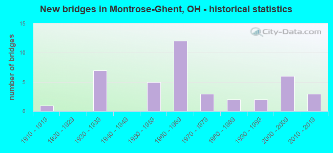
- New bridges - historical statistics
- 11910-1919
- 71930-1939
- 51950-1959
- 121960-1969
- 31970-1979
- 21980-1989
- 21990-1999
- 62000-2009
- 32010-2019
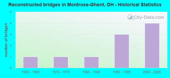
- Reconstructed bridges - Historical Statistics
- 11960-1969
- 11970-1979
- 11980-1989
- 31990-1999
- 42000-2009
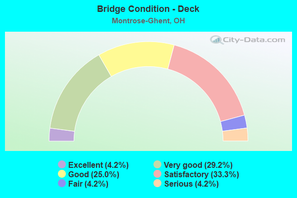
- Bridge Condition - Deck
- 4.2%Excellent
- 29.2%Very good
- 25.0%Good
- 33.3%Satisfactory
- 4.2%Fair
- 4.2%Serious
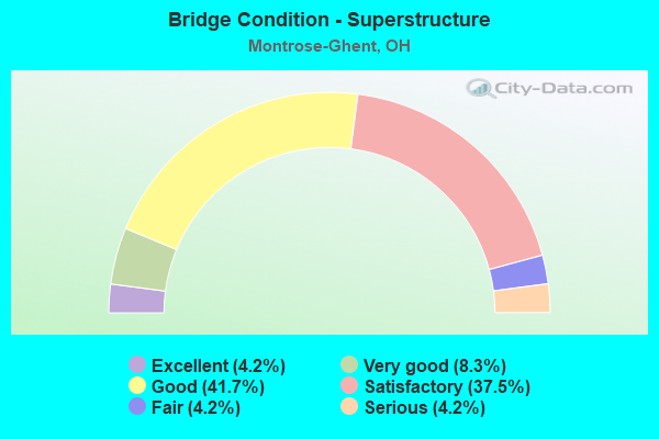
- Bridge Condition - Superstructure
- 4.2%Excellent
- 8.3%Very good
- 41.7%Good
- 37.5%Satisfactory
- 4.2%Fair
- 4.2%Serious
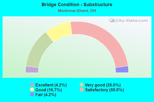
- Bridge Condition - Substructure
- 4.2%Excellent
- 25.0%Very good
- 16.7%Good
- 50.0%Satisfactory
- 4.2%Fair
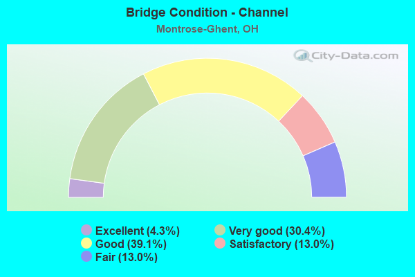
- Bridge Condition - Channel
- 4.3%Excellent
- 30.4%Very good
- 39.1%Good
- 13.0%Satisfactory
- 13.0%Fair
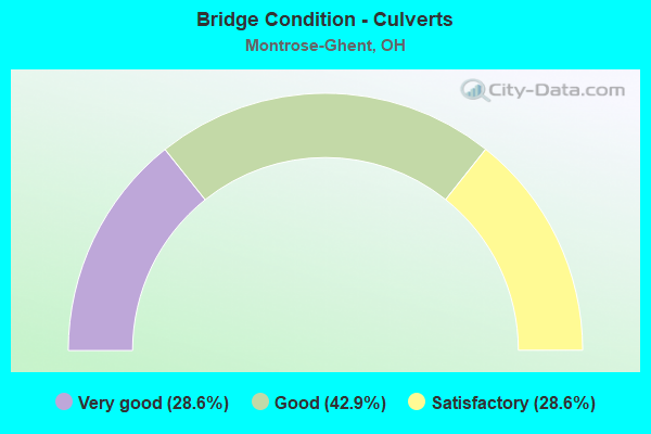
- Bridge Condition - Culverts
- 28.6%Very good
- 42.9%Good
- 28.6%Satisfactory
Find on map >> Show street view
Structure Number: 5205719, Location: 1.39 MI S OF IR 271 (Lat: 41.172211, Lng: -81.741831), Route carried "on" structure: State highway 94, Year Built: 1988, Status: Open, Structure Length: 2.35m (7.71ft), Average Daily Traffic: 7,342 (year 2015), Truck Traffic: 6%, Average Future Daily Traffic: 10,191 (year 2035), Design Load: HS 20, Features Intersected: DITCH
Minimum Vertical Clearance: 30+ m (98+ ft), Kilometerpoint: 21.147, Lanes on structure: 2, Owner: State Highway Agency, Approaching Roadway Width: 12.2m (40.0ft), Skew: 2 degrees, Material/Design: Concrete continuous, Design/Construction: Slab, Number Of Spans In Main Unit: 3, Length of Maximum Span: 8.8m (28.9ft), Curb-To-Curb Width: 12.3m (40.4ft), Out-to-Out Width: 12.6m (41.3ft)
Condition: Deck: Satisfactory, Superstructure: Satisfactory, Substructure: Satisfactory, Channel: Good, Operating Rating: 42.1 metric tons, Method Used To Determine Operating Rating: Load Factor (LF) rating reported by rating factor (RF) method using MS18 loading, Inventory Rating: 32.4 metric tons, Method Used To Determine Inventory Rating: Load Factor (LF) rating reported by rating factor (RF) method using MS18 loading, Structural Evaluation: Equal to present minimum criteria, Deck Geometry: Somewhat better than minimum adequacy, Waterway Adequacy: Better than present minimum criteria, Approach Roadway Alignment: Equal to present desirable criteria, Designated Inspection Frequency: Every 12 months, Inspection Date: October 2021, Deck Structure Type: Concrete Cast-file-Place, Wearing Surface/Protective System: Wearing Surface: Monolithic Concrete, Deck Protection: Epoxy Coated Reinforcing
Find on map >> Show street view
Structure Number: 520732, Location: 1.74 MILES EAST OF SR94 (Lat: 41.195831, Lng: -81.710169), Route carried "on" structure: County highway C0044, Year Built: 1970, Status: Open, Structure Length: 8.82m (28.94ft), Average Daily Traffic: 765 (year 2015), Truck Traffic: 8%, Average Future Daily Traffic: 42,248 (year 2035), Design Load: H 15, Features Intersected: OVER MED-271 -0526, Facility Carried by Structure: CR-44 State Rd
Minimum Vertical Clearance: 30+ m (98+ ft), Kilometerpoint: 0.000, Lanes on structure: 2, Lanes under structure: 4, Owner: State Highway Agency, Approaching Roadway Width: 10.7m (35.1ft), Skew: 1 degrees, Material/Design: Steel continuous, Design/Construction: Stringer/Multi-beam, Number Of Spans In Main Unit: 4, Length of Maximum Span: 25.9m (85.0ft), Curb or Sidewalk Widths: Left: 0.6m (2.0ft), Right: 0.6m (2.0ft), Curb-To-Curb Width: 7.3m (24.0ft), Out-to-Out Width: 9.1m (29.9ft)
Condition: Deck: Satisfactory, Superstructure: Satisfactory, Substructure: Fair, Operating Rating: 42.1 metric tons, Method Used To Determine Operating Rating: Load Factor (LF) rating reported by rating factor (RF) method using MS18 loading, Inventory Rating: 29.2 metric tons, Method Used To Determine Inventory Rating: Load Factor (LF) rating reported by rating factor (RF) method using MS18 loading, Structural Evaluation: Somewhat better than minimum adequacy, Deck Geometry: Meets minimum limits, Underclear: Somewhat better than minimum adequacy, Approach Roadway Alignment: Better than present minimum criteria, Designated Inspection Frequency: Every 12 months, Inspection Date: November 2021, Deck Structure Type: Concrete Cast-file-Place, Wearing Surface/Protective System: Wearing Surface: Latex Concrete
Find on map >> Show street view
Structure Number: 5234027, Location: 3506' E of CH 44 (Lat: 41.188350, Lng: -81.697511), Route carried "on" structure: County highway 37, Year Built: 2018, Status: Open, Structure Length: 0.73m (2.40ft), Average Daily Traffic: 580 (year 2017), Truck Traffic: 3%, Average Future Daily Traffic: 632 (year 2037), Design Load: HL 93, Features Intersected: Trib of E Br Rocky River
Minimum Vertical Clearance: 30+ m (98+ ft), Kilometerpoint: 13.181, Lanes on structure: 2, Owner: County Highway Agency, Approaching Roadway Width: 6.1m (20.0ft), Material/Design: Concrete, Design/Construction: Culvert, Number Of Spans In Main Unit: 1, Length of Maximum Span: 7.3m (24.0ft)
Condition: Channel: Very good, Culverts: Very good, Operating Rating: 97.2 metric tons, Method Used To Determine Operating Rating: Load and Resistance Factor Rating (LRFR) rating reported by rating factor(RF) method using HL-93 loadings, Inventory Rating: 77.8 metric tons, Method Used To Determine Inventory Rating: Load and Resistance Factor Rating (LRFR) rating reported by rating factor(RF) method using HL-93 loadings, Structural Evaluation: Equal to present desirable criteria, Waterway Adequacy: Better than present minimum criteria, Approach Roadway Alignment: Equal to present desirable criteria, Length Of Structure Improvement: 0.73m (2.40ft), Designated Inspection Frequency: Every 24 months, Inspection Date: October 2021, Wearing Surface/Protective System: Wearing Surface: Bituminous
Find on map >> Show street view
Structure Number: 5239184, Location: 700' N OF RD 61 (Lat: 41.161300, Lng: -81.735939), Route carried "on" structure: County highway 174, Year Built: 1976, Status: Open, Structure Length: 0.85m (2.79ft), Average Daily Traffic: 460 (year 2015), Truck Traffic: 7%, Average Future Daily Traffic: 638 (year 2035), Design Load: HS 20, Features Intersected: GRANGER DITCH
Minimum Vertical Clearance: 30+ m (98+ ft), Kilometerpoint: 0.209, Lanes on structure: 2, Owner: County Highway Agency, Approaching Roadway Width: 5.5m (18.0ft), Skew: 3 degrees, Material/Design: Steel, Design/Construction: Culvert, Number Of Spans In Main Unit: 2, Length of Maximum Span: 3.0m (9.8ft)
Condition: Channel: Good, Culverts: Good, Operating Rating: 97.2 metric tons, Method Used To Determine Operating Rating: Load Factor (LF) rating reported by rating factor (RF) method using MS18 loading, Inventory Rating: 68.0 metric tons, Method Used To Determine Inventory Rating: Load Factor (LF) rating reported by rating factor (RF) method using MS18 loading, Structural Evaluation: Better than present minimum criteria, Waterway Adequacy: Better than present minimum criteria, Approach Roadway Alignment: Equal to present minimum criteria, Designated Inspection Frequency: Every 24 months, Inspection Date: October 2021
Find on map >> Show street view
Structure Number: 5244471, Location: 0.50 MI E OF SR 94 (Lat: 41.171989, Lng: -81.733139), Route carried "on" structure: County highway 66, Year Built: 1991, Status: Open, Structure Length: 1.04m (3.41ft), Average Daily Traffic: 653 (year 2015), Truck Traffic: 8%, Average Future Daily Traffic: 906 (year 2035), Design Load: HS 20+Mod, Features Intersected: GRANGER DITCH
Minimum Vertical Clearance: 30+ m (98+ ft), Kilometerpoint: 4.812, Lanes on structure: 2, Owner: County Highway Agency, Approaching Roadway Width: 9.1m (29.9ft), Material/Design: Concrete, Design/Construction: Culvert, Number Of Spans In Main Unit: 1, Length of Maximum Span: 9.8m (32.2ft)
Condition: Channel: Good, Culverts: Good, Operating Rating: 48.6 metric tons, Method Used To Determine Operating Rating: Load Factor (LF) rating reported by rating factor (RF) method using MS18 loading, Inventory Rating: 29.2 metric tons, Method Used To Determine Inventory Rating: Load Factor (LF) rating reported by rating factor (RF) method using MS18 loading, Structural Evaluation: Better than present minimum criteria, Waterway Adequacy: Better than present minimum criteria, Approach Roadway Alignment: Better than present minimum criteria, Designated Inspection Frequency: Every 24 months, Inspection Date: October 2021, Wearing Surface/Protective System: Membrane: Built-up, Deck Protection: Epoxy Coated Reinforcing
Find on map >> Show street view
Structure Number: 7700857, Location: 1.35 MI W OF IR 77 (Lat: 41.135831, Lng: -81.676639), Route carried "on" structure: State highway 18, Year Built: 2016, Status: Open, Structure Length: 1.14m (3.74ft), Average Daily Traffic: 27,320 (year 2015), Truck Traffic: 8%, Average Future Daily Traffic: 35,830 (year 2035), Design Load: HL 93, Features Intersected: YELLOW CREEK
Minimum Vertical Clearance: 30+ m (98+ ft), Kilometerpoint: 0.869, Lanes on structure: 5, Base Highway Network: Yes, Owner: State Highway Agency, Approaching Roadway Width: 18.3m (60.0ft), Skew: 1 degrees, Material/Design: Concrete, Design/Construction: Culvert, Number Of Spans In Main Unit: 1, Length of Maximum Span: 11.0m (36.1ft)
Condition: Channel: Good, Culverts: Very good, Operating Rating: 97.2 metric tons, Method Used To Determine Operating Rating: Load and Resistance Factor Rating (LRFR) rating reported by rating factor(RF) method using HL-93 loadings, Inventory Rating: 90.7 metric tons, Method Used To Determine Inventory Rating: Load and Resistance Factor Rating (LRFR) rating reported by rating factor(RF) method using HL-93 loadings, Structural Evaluation: Equal to present desirable criteria, Waterway Adequacy: Superior to present desirable criteria, Approach Roadway Alignment: Equal to present minimum criteria, Length Of Structure Improvement: 1.10m (3.61ft), Designated Inspection Frequency: Every 24 months, Inspection Date: September 2021, Total Project Cost: $7,699,000
Find on map >> Show street view
Structure Number: 7704054, Location: JCT OF IR 77 AND SR 18 (Lat: 41.135769, Lng: -81.650731), Route carried "on" structure: Interstate 77, Year Built: 1957, Year Reconstructed: 1998, Status: Open, Structure Length: 5.49m (18.01ft), Average Daily Traffic: 46,212 (year 2015), Truck Traffic: 7%, Average Future Daily Traffic: 64,142 (year 2035), Design Load: HS 20+Mod, Features Intersected: OVER SUM-SR 18-1.88
Minimum Vertical Clearance: 30+ m (98+ ft), Kilometerpoint: 37.337, Lanes on structure: 8, Lanes under structure: 6, Base Highway Network: Yes, Owner: State Highway Agency, Approaching Roadway Width: 45.1m (148.0ft), Skew: 30 degrees, Material/Design: Steel continuous, Design/Construction: Stringer/Multi-beam, Number Of Spans In Main Unit: 4, Length of Maximum Span: 16.8m (55.1ft), Curb-To-Curb Width: 42.7m (140.1ft), Out-to-Out Width: 45.7m (149.9ft)
Condition: Deck: Very good, Superstructure: Good, Substructure: Good, Operating Rating: 42.1 metric tons, Method Used To Determine Operating Rating: Allowable Stress (AS) rating reported by rating factor (RF) method using MS18 loading, Inventory Rating: 32.4 metric tons, Method Used To Determine Inventory Rating: Allowable Stress (AS) rating reported by rating factor (RF) method using MS18 loading, Structural Evaluation: Better than present minimum criteria, Deck Geometry: Superior to present desirable criteria, Underclear: Somewhat better than minimum adequacy, Approach Roadway Alignment: Equal to present desirable criteria, Designated Inspection Frequency: Every 24 months, Inspection Date: July 2021, Deck Structure Type: Concrete Cast-file-Place, Wearing Surface/Protective System: Wearing Surface: Monolithic Concrete, Deck Protection: Epoxy Coated Reinforcing
Find on map >> Show street view
Structure Number: 7704119, Location: 1.51 MI N OF SR 18 (Lat: 41.150569, Lng: -81.630619), Route carried "on" structure: County highway C0098, Year Built: 1963, Year Reconstructed: 2012, Status: Open, Structure Length: 4.94m (16.21ft), Average Daily Traffic: 13,434 (year 2015), Truck Traffic: 7%, Average Future Daily Traffic: 34,378 (year 2035), Design Load: HS 20+Mod, Features Intersected: I-77 NORTHBOUND, Facility Carried by Structure: GHENT ROAD (CH-98)
Minimum Vertical Clearance: 30+ m (98+ ft), Kilometerpoint: 2.832, Lanes on structure: 4, Lanes under structure: 2, Owner: State Highway Agency, Approaching Roadway Width: 23.5m (77.1ft), Material/Design: Steel continuous, Design/Construction: Stringer/Multi-beam, Number Of Spans In Main Unit: 3, Length of Maximum Span: 20.1m (65.9ft), Curb-To-Curb Width: 21.5m (70.5ft), Out-to-Out Width: 22.9m (75.1ft)
Condition: Deck: Very good, Superstructure: Good, Substructure: Very good, Operating Rating: 42.1 metric tons, Method Used To Determine Operating Rating: Load Factor (LF) rating reported by rating factor (RF) method using MS18 loading, Inventory Rating: 32.4 metric tons, Method Used To Determine Inventory Rating: Load Factor (LF) rating reported by rating factor (RF) method using MS18 loading, Structural Evaluation: Better than present minimum criteria, Deck Geometry: Superior to present desirable criteria, Underclear: High priority of corrective action, Approach Roadway Alignment: Better than present minimum criteria, Designated Inspection Frequency: Every 24 months, Inspection Date: July 2021, Deck Structure Type: Concrete Cast-file-Place, Wearing Surface/Protective System: Wearing Surface: Monolithic Concrete, Deck Protection: Epoxy Coated Reinforcing
Find on map >> Show street view
Structure Number: 7704143, Location: 1.51 MI N OF SR 18 (Lat: 41.151181, Lng: -81.631581), Route carried "on" structure: County highway C0098, Year Built: 1963, Year Reconstructed: 2012, Status: Open, Structure Length: 5.46m (17.91ft), Average Daily Traffic: 13,434 (year 2015), Truck Traffic: 7%, Average Future Daily Traffic: 34,378 (year 2035), Design Load: HS 20+Mod, Features Intersected: I-77 SOUTHBOUND, Facility Carried by Structure: GHENT ROAD (CH-98)
Minimum Vertical Clearance: 30+ m (98+ ft), Kilometerpoint: 2.929, Lanes on structure: 4, Lanes under structure: 3, Owner: State Highway Agency, Approaching Roadway Width: 23.5m (77.1ft), Skew: 1 degrees, Material/Design: Steel continuous, Design/Construction: Stringer/Multi-beam, Number Of Spans In Main Unit: 3, Length of Maximum Span: 22.3m (73.2ft), Curb-To-Curb Width: 21.5m (70.5ft), Out-to-Out Width: 22.9m (75.1ft)
Condition: Deck: Very good, Superstructure: Good, Substructure: Very good, Operating Rating: 42.1 metric tons, Method Used To Determine Operating Rating: Load Factor (LF) rating reported by rating factor (RF) method using MS18 loading, Inventory Rating: 32.4 metric tons, Method Used To Determine Inventory Rating: Load Factor (LF) rating reported by rating factor (RF) method using MS18 loading, Structural Evaluation: Better than present minimum criteria, Deck Geometry: Superior to present desirable criteria, Underclear: High priority of corrective action, Approach Roadway Alignment: Better than present minimum criteria, Designated Inspection Frequency: Every 24 months, Inspection Date: July 2021, Deck Structure Type: Concrete Cast-file-Place, Wearing Surface/Protective System: Wearing Surface: Monolithic Concrete, Deck Protection: Epoxy Coated Reinforcing
Find on map >> Show street view
Structure Number: 7704186, Location: 1.98 MI N OF SR 18 (Lat: 41.156339, Lng: -81.626761), Route carried "on" structure: Interstate 77, Year Built: 2002, Status: Open, Structure Length: 14.75m (48.39ft), Average Daily Traffic: 29,455 (year 2015), Truck Traffic: 7%, Average Future Daily Traffic: 40,884 (year 2035), Design Load: HS 25 or greater, Features Intersected: OVER CR-33 & YELLOW CREE
Minimum Vertical Clearance: 30+ m (98+ ft), Kilometerpoint: 40.443, Lanes on structure: 2, Lanes under structure: 2, Base Highway Network: Yes, Owner: State Highway Agency, Approaching Roadway Width: 11.6m (38.1ft), Material/Design: Prestressed concrete continuous, Design/Construction: Stringer/Multi-beam, Number Of Spans In Main Unit: 4, Length of Maximum Span: 39.3m (128.9ft), Curb-To-Curb Width: 18.9m (62.0ft), Out-to-Out Width: 19.8m (65.0ft)
Condition: Deck: Very good, Superstructure: Very good, Substructure: Very good, Channel: Very good, Operating Rating: 42.1 metric tons, Method Used To Determine Operating Rating: Load Factor (LF) rating reported by rating factor (RF) method using MS18 loading, Inventory Rating: 32.4 metric tons, Method Used To Determine Inventory Rating: Load Factor (LF) rating reported by rating factor (RF) method using MS18 loading, Structural Evaluation: Equal to present desirable criteria, Deck Geometry: Superior to present desirable criteria, Underclear: Superior to present desirable criteria, Waterway Adequacy: Better than present minimum criteria, Approach Roadway Alignment: Better than present minimum criteria, Designated Inspection Frequency: Every 24 months, Inspection Date: July 2021, Deck Structure Type: Concrete Cast-file-Place, Wearing Surface/Protective System: Wearing Surface: Monolithic Concrete, Membrane: Epoxy, Deck Protection: Epoxy Coated Reinforcing
Find on map >> Show street view
Structure Number: 7704194, Location: 1.98 MI N OF SR 18 (Lat: 41.156281, Lng: -81.626231), Route carried "on" structure: Interstate 77, Year Built: 2002, Status: Open, Structure Length: 14.75m (48.39ft), Average Daily Traffic: 29,455 (year 2015), Truck Traffic: 7%, Average Future Daily Traffic: 40,884 (year 2035), Design Load: HS 20+Mod, Features Intersected: OVER CR-33 & YELLOW CREE
Minimum Vertical Clearance: 30+ m (98+ ft), Kilometerpoint: 40.443, Lanes on structure: 2, Lanes under structure: 2, Base Highway Network: Yes, Owner: State Highway Agency, Approaching Roadway Width: 11.6m (38.1ft), Material/Design: Prestressed concrete continuous, Design/Construction: Stringer/Multi-beam, Number Of Spans In Main Unit: 4, Length of Maximum Span: 39.3m (128.9ft), Curb-To-Curb Width: 18.9m (62.0ft), Out-to-Out Width: 19.8m (65.0ft)
Condition: Deck: Very good, Superstructure: Very good, Substructure: Very good, Channel: Very good, Operating Rating: 42.1 metric tons, Method Used To Determine Operating Rating: Load Factor (LF) rating reported by rating factor (RF) method using MS18 loading, Inventory Rating: 32.4 metric tons, Method Used To Determine Inventory Rating: Load Factor (LF) rating reported by rating factor (RF) method using MS18 loading, Structural Evaluation: Equal to present desirable criteria, Deck Geometry: Superior to present desirable criteria, Underclear: Superior to present desirable criteria, Waterway Adequacy: Equal to present desirable criteria, Approach Roadway Alignment: Better than present minimum criteria, Designated Inspection Frequency: Every 24 months, Inspection Date: July 2021, Deck Structure Type: Concrete Cast-file-Place, Wearing Surface/Protective System: Wearing Surface: Monolithic Concrete, Membrane: Epoxy, Deck Protection: Epoxy Coated Reinforcing
Find on map >> Show street view
Structure Number: 7704232, Location: 2.48 MI N OF SR 18 (Lat: 41.163439, Lng: -81.625889), Route carried "on" structure: City street M1859, Year Built: 1963, Year Reconstructed: 2012, Status: Open, Structure Length: 8.72m (28.61ft), Average Daily Traffic: 1,295 (year 2015), Truck Traffic: 5%, Average Future Daily Traffic: 81,766 (year 2035), Design Load: H 15, Features Intersected: I-77, Facility Carried by Structure: MARTADALE RD TR 18
Minimum Vertical Clearance: 30+ m (98+ ft), Kilometerpoint: 0.531, Lanes on structure: 2, Lanes under structure: 4, Owner: State Highway Agency, Approaching Roadway Width: 9.8m (32.2ft), Material/Design: Steel continuous, Design/Construction: Stringer/Multi-beam, Number Of Spans In Main Unit: 4, Length of Maximum Span: 25.3m (83.0ft), Curb-To-Curb Width: 7.3m (24.0ft), Out-to-Out Width: 9.3m (30.5ft)
Condition: Deck: Very good, Superstructure: Good, Substructure: Very good, Operating Rating: 32.4 metric tons, Method Used To Determine Operating Rating: Load and Resistance Factor Rating (LRFR) rating reported by rating factor(RF) method using HL-93 loadings, Inventory Rating: 22.7 metric tons, Method Used To Determine Inventory Rating: Load and Resistance Factor Rating (LRFR) rating reported by rating factor(RF) method using HL-93 loadings, Structural Evaluation: Equal to present minimum criteria, Deck Geometry: Meets minimum limits, Underclear: High priority of corrective action, Approach Roadway Alignment: Equal to present minimum criteria, Designated Inspection Frequency: Every 24 months, Inspection Date: July 2021, Deck Structure Type: Concrete Cast-file-Place, Wearing Surface/Protective System: Wearing Surface: Monolithic Concrete, Deck Protection: Epoxy Coated Reinforcing
Find on map >> Show street view
Structure Number: 7704267, Location: 2.86 MI N OF SR 18 (Lat: 41.168889, Lng: -81.626311), Route carried "on" structure: Interstate 77, Year Built: 1963, Year Reconstructed: 2001, Status: Open, Structure Length: 3.70m (12.14ft), Average Daily Traffic: 29,455 (year 2018), Truck Traffic: 7%, Average Future Daily Traffic: 40,884 (year 2038), Design Load: HS 20+Mod, Features Intersected: OVER BATH RD CR-48
Minimum Vertical Clearance: 30+ m (98+ ft), Kilometerpoint: 41.956, Lanes on structure: 2, Lanes under structure: 2, Base Highway Network: Yes, Owner: State Highway Agency, Approaching Roadway Width: 11.6m (38.1ft), Material/Design: Steel continuous, Design/Construction: Stringer/Multi-beam, Number Of Spans In Main Unit: 3, Length of Maximum Span: 13.7m (44.9ft), Curb-To-Curb Width: 18.6m (61.0ft), Out-to-Out Width: 19.5m (64.0ft)
Condition: Deck: Good, Superstructure: Good, Substructure: Good, Operating Rating: 42.1 metric tons, Method Used To Determine Operating Rating: Allowable Stress (AS) rating reported by rating factor (RF) method using MS18 loading, Inventory Rating: 32.4 metric tons, Method Used To Determine Inventory Rating: Allowable Stress (AS) rating reported by rating factor (RF) method using MS18 loading, Structural Evaluation: Better than present minimum criteria, Deck Geometry: Superior to present desirable criteria, Underclear: Equal to present minimum criteria, Approach Roadway Alignment: Equal to present minimum criteria, Designated Inspection Frequency: Every 24 months, Inspection Date: May 2021, Deck Structure Type: Concrete Cast-file-Place, Wearing Surface/Protective System: Wearing Surface: Monolithic Concrete, Membrane: Preformed Fabric, Deck Protection: Epoxy Coated Reinforcing
Find on map >> Show street view
Structure Number: 7704291, Location: 2.86 MI N OF SR 18 (Lat: 41.168889, Lng: -81.625781), Route carried "on" structure: Interstate 77, Year Built: 1963, Year Reconstructed: 2001, Status: Open, Structure Length: 3.70m (12.14ft), Average Daily Traffic: 29,455 (year 2018), Truck Traffic: 7%, Average Future Daily Traffic: 40,884 (year 2038), Design Load: HS 20+Mod, Features Intersected: OVER BATH RD CR-48
Minimum Vertical Clearance: 30+ m (98+ ft), Kilometerpoint: 41.956, Lanes on structure: 2, Lanes under structure: 2, Base Highway Network: Yes, Owner: State Highway Agency, Approaching Roadway Width: 11.6m (38.1ft), Material/Design: Steel continuous, Design/Construction: Stringer/Multi-beam, Number Of Spans In Main Unit: 3, Length of Maximum Span: 13.7m (44.9ft), Curb-To-Curb Width: 18.6m (61.0ft), Out-to-Out Width: 19.5m (64.0ft)
Condition: Deck: Good, Superstructure: Good, Substructure: Good, Operating Rating: 42.1 metric tons, Method Used To Determine Operating Rating: Allowable Stress (AS) rating reported by rating factor (RF) method using MS18 loading, Inventory Rating: 32.4 metric tons, Method Used To Determine Inventory Rating: Allowable Stress (AS) rating reported by rating factor (RF) method using MS18 loading, Structural Evaluation: Better than present minimum criteria, Deck Geometry: Superior to present desirable criteria, Underclear: Equal to present minimum criteria, Approach Roadway Alignment: Equal to present minimum criteria, Designated Inspection Frequency: Every 24 months, Inspection Date: May 2021, Deck Structure Type: Concrete Cast-file-Place, Wearing Surface/Protective System: Wearing Surface: Monolithic Concrete, Membrane: Preformed Fabric, Deck Protection: Epoxy Coated Reinforcing
Find on map >> Show street view
Structure Number: 7704321, Location: 3.18 MI S OF SR 176 (Lat: 41.175569, Lng: -81.625611), Route carried "on" structure: County highway C0196, Year Built: 1963, Year Reconstructed: 2012, Status: Open, Structure Length: 8.60m (28.22ft), Average Daily Traffic: 1,619 (year 2018), Truck Traffic: 5%, Average Future Daily Traffic: 81,766 (year 2038), Design Load: H 15, Features Intersected: I-77, Facility Carried by Structure: SHADE RD (CR 196)
Minimum Vertical Clearance: 30+ m (98+ ft), Kilometerpoint: 85.295, Lanes on structure: 2, Lanes under structure: 4, Owner: State Highway Agency, Approaching Roadway Width: 9.1m (29.9ft), Material/Design: Steel continuous, Design/Construction: Stringer/Multi-beam, Number Of Spans In Main Unit: 4, Length of Maximum Span: 25.0m (82.0ft), Curb-To-Curb Width: 7.3m (24.0ft), Out-to-Out Width: 9.3m (30.5ft)
Condition: Deck: Very good, Superstructure: Good, Substructure: Very good, Operating Rating: 22.7 metric tons, Method Used To Determine Operating Rating: Load Factor (LF) rating reported by rating factor (RF) method using MS18 loading, Inventory Rating: 16.2 metric tons, Method Used To Determine Inventory Rating: Load Factor (LF) rating reported by rating factor (RF) method using MS18 loading, Structural Evaluation: Meets minimum limits, Deck Geometry: Meets minimum limits, Underclear: High priority of corrective action, Approach Roadway Alignment: Equal to present minimum criteria, Designated Inspection Frequency: Every 24 months, Inspection Date: May 2021, Deck Structure Type: Concrete Cast-file-Place, Wearing Surface/Protective System: Wearing Surface: Monolithic Concrete, Deck Protection: Epoxy Coated Reinforcing
Find on map >> Show street view
Structure Number: 7732023, Location: 200 FT N OF VELLOW CREEK (Lat: 41.157639, Lng: -81.635881), Route carried "on" structure: County highway C0017, Year Built: 1930, Status: Open, Structure Length: 2.35m (7.71ft), Average Daily Traffic: 10,940 (year 2015), Truck Traffic: 5%, Average Future Daily Traffic: 15,185 (year 2035), Design Load: H 15, Features Intersected: YELLOW CREEK, Facility Carried by Structure: CLEVE-MASSILLON RD
Minimum Vertical Clearance: 30+ m (98+ ft), Kilometerpoint: 28.373, Lanes on structure: 4, Owner: County Highway Agency, Approaching Roadway Width: 14.0m (45.9ft), Skew: 1 degrees, Material/Design: Concrete, Design/Construction: Tee Beam, Number Of Spans In Main Unit: 2, Length of Maximum Span: 11.0m (36.1ft), Curb or Sidewalk Widths: Left: 1.5m (4.9ft), Right: 1.5m (4.9ft), Curb-To-Curb Width: 16.5m (54.1ft), Out-to-Out Width: 17.8m (58.4ft)
Condition: Deck: Satisfactory, Superstructure: Satisfactory, Substructure: Satisfactory, Channel: Satisfactory, Operating Rating: 38.9 metric tons, Method Used To Determine Operating Rating: Load Factor (LF) rating reported by rating factor (RF) method using MS18 loading, Inventory Rating: 22.7 metric tons, Method Used To Determine Inventory Rating: Load Factor (LF) rating reported by rating factor (RF) method using MS18 loading, Structural Evaluation: Somewhat better than minimum adequacy, Deck Geometry: Meets minimum limits, Waterway Adequacy: Better than present minimum criteria, Approach Roadway Alignment: Equal to present desirable criteria, Designated Inspection Frequency: Every 12 months, Inspection Date: March 2021, Deck Structure Type: Concrete Cast-file-Place, Wearing Surface/Protective System: Wearing Surface: Bituminous
Find on map >> Show street view
Structure Number: 7732031, Location: 2200 FT N OF GRANGER RD (Lat: 41.162919, Lng: -81.636900), Route carried "on" structure: County highway C0017, Year Built: 1930, Status: Open, Structure Length: 1.46m (4.79ft), Average Daily Traffic: 10,940 (year 2018), Truck Traffic: 5%, Average Future Daily Traffic: 15,185 (year 2038), Design Load: H 15, Features Intersected: BR NORTH FORK STREAM, Facility Carried by Structure: CLEVE-MASSILLON RD
Minimum Vertical Clearance: 30+ m (98+ ft), Kilometerpoint: 29.000, Lanes on structure: 2, Owner: County Highway Agency, Approaching Roadway Width: 12.2m (40.0ft), Skew: 4 degrees, Material/Design: Concrete continuous, Design/Construction: Slab, Number Of Spans In Main Unit: 2, Length of Maximum Span: 7.0m (23.0ft), Curb or Sidewalk Widths: Left: 0.0m, Right: 1.5m (4.9ft), Curb-To-Curb Width: 13.7m (44.9ft), Out-to-Out Width: 17.8m (58.4ft)
Condition: Deck: Satisfactory, Superstructure: Satisfactory, Substructure: Satisfactory, Channel: Good, Operating Rating: 29.2 metric tons, Method Used To Determine Operating Rating: Load and Resistance Factor Rating (LRFR) rating reported by rating factor(RF) method using HL-93 loadings, Inventory Rating: 22.7 metric tons, Method Used To Determine Inventory Rating: Load and Resistance Factor Rating (LRFR) rating reported by rating factor(RF) method using HL-93 loadings, Structural Evaluation: Somewhat better than minimum adequacy, Deck Geometry: Superior to present desirable criteria, Waterway Adequacy: Better than present minimum criteria, Approach Roadway Alignment: Equal to present desirable criteria, Designated Inspection Frequency: Every 12 months, Inspection Date: March 2021, Deck Structure Type: Concrete Cast-file-Place, Wearing Surface/Protective System: Wearing Surface: Bituminous
Find on map >> Show street view
Structure Number: 7732058, Location: 600 FT W OF SHADE RD (Lat: 41.176881, Lng: -81.636569), Route carried "on" structure: County highway C0017, Year Built: 1930, Status: Open, Structure Length: 0.98m (3.22ft), Average Daily Traffic: 9,660 (year 2015), Truck Traffic: 5%, Average Future Daily Traffic: 13,408 (year 2035), Design Load: H 15, Features Intersected: NORTH FORK STREAM, Facility Carried by Structure: CLEVE-MASS RD
Minimum Vertical Clearance: 30+ m (98+ ft), Kilometerpoint: 30.561, Lanes on structure: 2, Owner: County Highway Agency, Approaching Roadway Width: 12.2m (40.0ft), Material/Design: Concrete continuous, Design/Construction: Slab, Number Of Spans In Main Unit: 2, Length of Maximum Span: 4.3m (14.1ft), Curb or Sidewalk Widths: Left: 0.5m (1.6ft), Right: 1.5m (4.9ft), Curb-To-Curb Width: 13.6m (44.6ft), Out-to-Out Width: 17.8m (58.4ft)
Condition: Deck: Satisfactory, Superstructure: Satisfactory, Substructure: Satisfactory, Channel: Good, Operating Rating: 42.1 metric tons, Method Used To Determine Operating Rating: Load Factor (LF) rating reported by rating factor (RF) method using MS18 loading, Inventory Rating: 25.9 metric tons, Method Used To Determine Inventory Rating: Load Factor (LF) rating reported by rating factor (RF) method using MS18 loading, Structural Evaluation: Equal to present minimum criteria, Deck Geometry: Superior to present desirable criteria, Waterway Adequacy: Better than present minimum criteria, Approach Roadway Alignment: Equal to present desirable criteria, Designated Inspection Frequency: Every 12 months, Inspection Date: January 2021, Deck Structure Type: Concrete Cast-file-Place, Wearing Surface/Protective System: Wearing Surface: Bituminous
Find on map >> Show street view
Structure Number: 7732082, Location: 1400 FT E OF CLEV-MASS RD (Lat: 41.157200, Lng: -81.630431), Route carried "on" structure: County highway C0033, Year Built: 1951, Status: Open, Structure Length: 2.38m (7.81ft), Average Daily Traffic: 4,150 (year 2018), Truck Traffic: 5%, Average Future Daily Traffic: 5,760 (year 2038), Features Intersected: YELLOW CREEK, Facility Carried by Structure: YELLOW CREEK RD
Minimum Vertical Clearance: 30+ m (98+ ft), Kilometerpoint: 0.418, Lanes on structure: 2, Owner: County Highway Agency, Approaching Roadway Width: 7.9m (25.9ft), Skew: 1 degrees, Material/Design: Concrete continuous, Design/Construction: Slab, Number Of Spans In Main Unit: 3, Length of Maximum Span: 9.1m (29.9ft), Curb-To-Curb Width: 10.5m (34.4ft), Out-to-Out Width: 11.5m (37.7ft)
Condition: Deck: Satisfactory, Superstructure: Satisfactory, Substructure: Satisfactory, Channel: Very good, Operating Rating: 42.1 metric tons, Method Used To Determine Operating Rating: Load Factor (LF) rating reported by rating factor (RF) method using MS18 loading, Inventory Rating: 25.9 metric tons, Method Used To Determine Inventory Rating: Load Factor (LF) rating reported by rating factor (RF) method using MS18 loading, Structural Evaluation: Equal to present minimum criteria, Deck Geometry: Somewhat better than minimum adequacy, Waterway Adequacy: Better than present minimum criteria, Approach Roadway Alignment: Equal to present desirable criteria, Designated Inspection Frequency: Every 12 months, Inspection Date: March 2021, Deck Structure Type: Concrete Cast-file-Place, Wearing Surface/Protective System: Wearing Surface: Bituminous
Find on map >> Show street view
Structure Number: 773209, Location: 300 FT W OF REVERE RD (Lat: 41.160119, Lng: -81.600261), Route carried "on" structure: County highway C0033, Year Built: 1938, Year Reconstructed: 1982, Status: Open, Structure Length: 1.98m (6.50ft), Average Daily Traffic: 5,390 (year 2018), Truck Traffic: 5%, Average Future Daily Traffic: 7,481 (year 2038), Design Load: HS 20+Mod, Features Intersected: YELLOW CREEK, Facility Carried by Structure: YELLOW CREEK RD
Minimum Vertical Clearance: 30+ m (98+ ft), Kilometerpoint: 3.347, Lanes on structure: 2, Owner: County Highway Agency, Approaching Roadway Width: 9.1m (29.9ft), Skew: 1 degrees, Material/Design: Prestressed concrete, Design/Construction: Box Beam or Girders - Multiple, Number Of Spans In Main Unit: 1, Length of Maximum Span: 18.3m (60.0ft), Curb or Sidewalk Widths: Left: 0.2m (0.7ft), Right: 0.2m (0.7ft), Curb-To-Curb Width: 10.6m (34.8ft), Out-to-Out Width: 11.9m (39.0ft)
Condition: Deck: Fair, Superstructure: Fair, Substructure: Satisfactory, Channel: Fair, Operating Rating: 51.8 metric tons, Method Used To Determine Operating Rating: Load Factor (LF) rating reported by rating factor (RF) method using MS18 loading, Inventory Rating: 32.4 metric tons, Method Used To Determine Inventory Rating: Load Factor (LF) rating reported by rating factor (RF) method using MS18 loading, Structural Evaluation: Somewhat better than minimum adequacy, Deck Geometry: Meets minimum limits, Waterway Adequacy: Superior to present desirable criteria, Approach Roadway Alignment: Equal to present minimum criteria, Designated Inspection Frequency: Every 12 months, Inspection Date: March 2021, Deck Structure Type: Concrete Cast-file-Place, Wearing Surface/Protective System: Wearing Surface: Integral Concrete
Find on map >> Show street view
Structure Number: 7732147, Location: 300 FT E OF SHAW ROAD (Lat: 41.160400, Lng: -81.652450), Route carried "on" structure: County highway C0079, Year Built: 1950, Status: Posted for load, Structure Length: 2.26m (7.41ft), Average Daily Traffic: 3,703 (year 2018), Truck Traffic: 5%, Average Future Daily Traffic: 5,140 (year 2038), Features Intersected: YELLOW CREEK, Facility Carried by Structure: GRANGER ROAD
Minimum Vertical Clearance: 30+ m (98+ ft), Kilometerpoint: 3.267, Lanes on structure: 2, Owner: County Highway Agency, Approaching Roadway Width: 9.1m (29.9ft), Skew: 3 degrees, Material/Design: Concrete continuous, Design/Construction: Slab, Number Of Spans In Main Unit: 3, Length of Maximum Span: 8.5m (27.9ft), Curb-To-Curb Width: 9.4m (30.8ft), Out-to-Out Width: 9.8m (32.2ft)
Condition: Deck: Satisfactory, Superstructure: Satisfactory, Substructure: Satisfactory, Channel: Good, Operating Rating: 32.4 metric tons, Method Used To Determine Operating Rating: Load Factor (LF) rating reported by rating factor (RF) method using MS18 loading, Inventory Rating: 19.4 metric tons, Method Used To Determine Inventory Rating: Load Factor (LF) rating reported by rating factor (RF) method using MS18 loading, Structural Evaluation: Somewhat better than minimum adequacy, Deck Geometry: Meets minimum limits, Waterway Adequacy: Better than present minimum criteria, Approach Roadway Alignment: Equal to present desirable criteria, Bridge Posting: Required (Relationship of Operating Rating to Maximum Legal Load: 30.0 - 39.9% below), Designated Inspection Frequency: Every 12 months, Inspection Date: March 2021, Deck Structure Type: Concrete Cast-file-Place, Wearing Surface/Protective System: Wearing Surface: Bituminous
Find on map >> Show street view
Structure Number: 7732155, Location: 1000 FT E OF SHAW RD (Lat: 41.160650, Lng: -81.649111), Route carried "on" structure: County highway C0079, Year Built: 1913, Year Reconstructed: 1972, Status: Posted for load, Structure Length: 1.98m (6.50ft), Average Daily Traffic: 3,703 (year 2015), Truck Traffic: 5%, Average Future Daily Traffic: 5,140 (year 2035), Design Load: HS 20, Features Intersected: YELLOW CREEK, Facility Carried by Structure: GRANGER RD
Minimum Vertical Clearance: 30+ m (98+ ft), Kilometerpoint: 3.557, Lanes on structure: 2, Owner: County Highway Agency, Approaching Roadway Width: 7.0m (23.0ft), Skew: 3 degrees, Material/Design: Prestressed concrete, Design/Construction: Box Beam or Girders - Multiple, Number Of Spans In Main Unit: 1, Length of Maximum Span: 18.3m (60.0ft), Curb-To-Curb Width: 7.0m (23.0ft), Out-to-Out Width: 7.3m (24.0ft)
Condition: Deck: Serious, Superstructure: Serious, Substructure: Satisfactory, Channel: Satisfactory, Operating Rating: 29.2 metric tons, Method Used To Determine Operating Rating: Load Factor (LF) rating reported by rating factor (RF) method using MS18 loading, Inventory Rating: 16.2 metric tons, Method Used To Determine Inventory Rating: Load Factor (LF) rating reported by rating factor (RF) method using MS18 loading, Structural Evaluation: High priority of corrective action, Deck Geometry: High priority of replacement, Waterway Adequacy: Better than present minimum criteria, Approach Roadway Alignment: Equal to present minimum criteria, Bridge Posting: Required (Relationship of Operating Rating to Maximum Legal Load: 30.0 - 39.9% below), Designated Inspection Frequency: Every 12 months, Other Special Inspection Frequency: Every 4 months, Inspection Date: November 2021, Other Special Inspection Date: November 2021, Wearing Surface/Protective System: Wearing Surface: Bituminous
Find on map >> Show street view
Structure Number: 7732163, Location: 300 FT W OF WYE ROAD (Lat: 41.158200, Lng: -81.637919), Route carried "on" structure: County highway C0079, Year Built: 1950, Status: Posted for load, Structure Length: 2.04m (6.69ft), Average Daily Traffic: 3,703 (year 2018), Truck Traffic: 5%, Average Future Daily Traffic: 5,140 (year 2038), Features Intersected: NORTH FORK, Facility Carried by Structure: GRANGER RD
Minimum Vertical Clearance: 30+ m (98+ ft), Kilometerpoint: 4.554, Lanes on structure: 2, Owner: County Highway Agency, Approaching Roadway Width: 8.5m (27.9ft), Skew: 3 degrees, Material/Design: Concrete continuous, Design/Construction: Slab, Number Of Spans In Main Unit: 3, Length of Maximum Span: 7.6m (24.9ft), Curb-To-Curb Width: 11.3m (37.1ft), Out-to-Out Width: 11.8m (38.7ft)
Condition: Deck: Good, Superstructure: Satisfactory, Substructure: Satisfactory, Channel: Fair, Operating Rating: 32.4 metric tons, Method Used To Determine Operating Rating: Load Factor (LF) rating reported by rating factor (RF) method using MS18 loading, Inventory Rating: 19.4 metric tons, Method Used To Determine Inventory Rating: Load Factor (LF) rating reported by rating factor (RF) method using MS18 loading, Structural Evaluation: Somewhat better than minimum adequacy, Deck Geometry: Somewhat better than minimum adequacy, Waterway Adequacy: Better than present minimum criteria, Approach Roadway Alignment: Equal to present desirable criteria, Bridge Posting: Required (Relationship of Operating Rating to Maximum Legal Load: 30.0 - 39.9% below), Designated Inspection Frequency: Every 12 months, Inspection Date: March 2021, Deck Structure Type: Concrete Cast-file-Place, Wearing Surface/Protective System: Wearing Surface: Bituminous
Find on map >> Show street view
Structure Number: 7732171, Location: 600 FT E OF CLEVE-MASS RD (Lat: 41.175561, Lng: -81.635131), Route carried "on" structure: County highway C0196, Year Built: 1937, Status: Open, Structure Length: 0.85m (2.79ft), Average Daily Traffic: 1,619 (year 2018), Truck Traffic: 5%, Average Future Daily Traffic: 2,247 (year 2038), Design Load: H 15, Features Intersected: NORTH FORK, Facility Carried by Structure: SHADE RD
Minimum Vertical Clearance: 30+ m (98+ ft), Kilometerpoint: 0.161, Lanes on structure: 2, Owner: County Highway Agency, Approaching Roadway Width: 7.3m (24.0ft), Skew: 3 degrees, Material/Design: Concrete, Design/Construction: Slab, Number Of Spans In Main Unit: 1, Length of Maximum Span: 7.6m (24.9ft), Curb-To-Curb Width: 7.6m (24.9ft), Out-to-Out Width: 8.4m (27.6ft)
Condition: Deck: Good, Superstructure: Good, Substructure: Satisfactory, Channel: Very good, Operating Rating: 74.5 metric tons, Method Used To Determine Operating Rating: Load Factor (LF) rating reported by rating factor (RF) method using MS18 loading, Inventory Rating: 45.4 metric tons, Method Used To Determine Inventory Rating: Load Factor (LF) rating reported by rating factor (RF) method using MS18 loading, Structural Evaluation: Equal to present minimum criteria, Deck Geometry: Meets minimum limits, Waterway Adequacy: Better than present minimum criteria, Approach Roadway Alignment: Equal to present desirable criteria, Designated Inspection Frequency: Every 12 months, Inspection Date: March 2021, Deck Structure Type: Concrete Cast-file-Place, Wearing Surface/Protective System: Wearing Surface: Bituminous
Find on map >> Show street view
Structure Number: 7732198, Location: 300 FT S OF GRANGER ROAD (Lat: 41.155000, Lng: -81.656669), Route carried "on" structure: County highway C0200, Year Built: 1938, Status: Open, Structure Length: 0.91m (2.99ft), Average Daily Traffic: 4,434 (year 2018), Truck Traffic: 5%, Average Future Daily Traffic: 6,154 (year 2038), Design Load: H 15, Features Intersected: YELLOW CREEK, Facility Carried by Structure: CRYSTAL LAKE ROAD
Minimum Vertical Clearance: 30+ m (98+ ft), Kilometerpoint: 2.060, Lanes on structure: 2, Owner: County Highway Agency, Approaching Roadway Width: 8.8m (28.9ft), Skew: 1 degrees, Material/Design: Concrete, Design/Construction: Slab, Number Of Spans In Main Unit: 1, Length of Maximum Span: 7.9m (25.9ft), Curb or Sidewalk Widths: Left: 0.2m (0.7ft), Right: 0.2m (0.7ft), Curb-To-Curb Width: 9.1m (29.9ft), Out-to-Out Width: 10.2m (33.5ft)
Condition: Deck: Good, Superstructure: Good, Substructure: Good, Channel: Satisfactory, Operating Rating: 58.3 metric tons, Method Used To Determine Operating Rating: Load Factor (LF) rating reported by rating factor (RF) method using MS18 loading, Inventory Rating: 35.6 metric tons, Method Used To Determine Inventory Rating: Load Factor (LF) rating reported by rating factor (RF) method using MS18 loading, Structural Evaluation: Better than present minimum criteria, Deck Geometry: Meets minimum limits, Waterway Adequacy: Better than present minimum criteria, Approach Roadway Alignment: Equal to present desirable criteria, Designated Inspection Frequency: Every 24 months, Inspection Date: March 2021, Deck Structure Type: Concrete Cast-file-Place, Wearing Surface/Protective System: Wearing Surface: Bituminous
Find on map >> Show street view
Structure Number: 7732228, Location: 2200 FT S OF GRANGER RD (Lat: 41.150000, Lng: -81.665000), Route carried "on" structure: County highway C0253, Year Built: 1938, Year Reconstructed: 1986, Status: Open, Structure Length: 1.10m (3.61ft), Average Daily Traffic: 862 (year 2015), Truck Traffic: 5%, Average Future Daily Traffic: 1,196 (year 2035), Features Intersected: BR YELLOW CREEK, Facility Carried by Structure: HAMETOWN RD
Minimum Vertical Clearance: 30+ m (98+ ft), Kilometerpoint: 18.234, Lanes on structure: 2, Owner: County Highway Agency, Approaching Roadway Width: 11.6m (38.1ft), Material/Design: Concrete, Design/Construction: Tee Beam, Number Of Spans In Main Unit: 1, Length of Maximum Span: 9.8m (32.2ft), Curb-To-Curb Width: 11.0m (36.1ft), Out-to-Out Width: 11.4m (37.4ft)
Condition: Deck: Good, Superstructure: Satisfactory, Substructure: Satisfactory, Channel: Very good, Operating Rating: 40.8 metric tons, Method Used To Determine Operating Rating: Field evaluation and documented engineering judgment, Inventory Rating: 32.7 metric tons, Method Used To Determine Inventory Rating: Field evaluation and documented engineering judgment, Structural Evaluation: Equal to present minimum criteria, Deck Geometry: Better than present minimum criteria, Waterway Adequacy: Better than present minimum criteria, Approach Roadway Alignment: Equal to present minimum criteria, Length Of Structure Improvement: 1.10m (3.61ft), Designated Inspection Frequency: Every 12 months, Inspection Date: Febuary 2021, Bridge Improvement Cost: $18,000, Roadway Improvement Cost: $2,000, Total Project Cost: $20,000, Deck Structure Type: Concrete Cast-file-Place, Wearing Surface/Protective System: Wearing Surface: Epoxy Overlay
Find on map >> Show street view
Structure Number: 7732287, Location: 3300 FT E OF CLE-MASS RD (Lat: 41.168889, Lng: -81.648889), Route carried "on" structure: County highway 48, Year Built: 2004, Status: Open, Structure Length: 0.67m (2.20ft), Average Daily Traffic: 2,679 (year 2018), Truck Traffic: 1%, Average Future Daily Traffic: 3,718 (year 2038), Design Load: HS 25 or greater, Features Intersected: BATH DITCH
Minimum Vertical Clearance: 30+ m (98+ ft), Kilometerpoint: 3.170, Lanes on structure: 2, Owner: County Highway Agency, Approaching Roadway Width: 8.8m (28.9ft), Material/Design: Aluminum, Iron, Design/Construction: Culvert, Number Of Spans In Main Unit: 1, Length of Maximum Span: 6.7m (22.0ft)
Condition: Channel: Very good, Culverts: Good, Operating Rating: 40.8 metric tons, Method Used To Determine Operating Rating: Field evaluation and documented engineering judgment, Inventory Rating: 32.7 metric tons, Method Used To Determine Inventory Rating: Field evaluation and documented engineering judgment, Structural Evaluation: Better than present minimum criteria, Waterway Adequacy: Superior to present desirable criteria, Approach Roadway Alignment: Superior to present desirable criteria, Designated Inspection Frequency: Every 24 months, Inspection Date: March 2021
Find on map >> Show street view
Structure Number: 7732295, Location: 1.25 Mi. N of SR18 (Lat: 41.153889, Lng: -81.686639), Route carried "on" structure: County highway C0002, Year Built: 2019, Status: Open, Structure Length: 1.13m (3.71ft), Average Daily Traffic: 2,830 (year 2016), Truck Traffic: 1%, Average Future Daily Traffic: 3,165 (year 2036), Design Load: HL 93, Features Intersected: BRANCH OF YELLOW CREEK, Facility Carried by Structure: MEDINA LINE RD.
Minimum Vertical Clearance: 30+ m (98+ ft), Kilometerpoint: 18.395, Lanes on structure: 2, Owner: County Highway Agency, Approaching Roadway Width: 9.8m (32.2ft), Material/Design: Prestressed concrete, Design/Construction: Box Beam or Girders - Multiple, Number Of Spans In Main Unit: 1, Length of Maximum Span: 10.7m (35.1ft), Curb-To-Curb Width: 9.8m (32.2ft), Out-to-Out Width: 9.8m (32.2ft)
Condition: Deck: Excellent, Superstructure: Excellent, Substructure: Excellent, Channel: Excellent, Operating Rating: 61.6 metric tons, Method Used To Determine Operating Rating: Load and Resistance Factor Rating (LRFR) rating reported by rating factor(RF) method using HL-93 loadings, Inventory Rating: 48.6 metric tons, Method Used To Determine Inventory Rating: Load and Resistance Factor Rating (LRFR) rating reported by rating factor(RF) method using HL-93 loadings, Structural Evaluation: Superior to present desirable criteria, Deck Geometry: Meets minimum limits, Waterway Adequacy: Superior to present desirable criteria, Approach Roadway Alignment: Equal to present desirable criteria, Designated Inspection Frequency: Every 12 months, Inspection Date: January 2021, Deck Structure Type: Concrete Cast-file-Place, Wearing Surface/Protective System: Wearing Surface: Monolithic Concrete, Deck Protection: Epoxy Coated Reinforcing
Find on map >> Show street view
Structure Number: 773243, Location: 800 FT N OF AKR-MEDINA RD (Lat: 41.138331, Lng: -81.670000), Route carried "on" structure: County highway C0253, Year Built: 1987, Status: Open, Structure Length: 1.04m (3.41ft), Average Daily Traffic: 862 (year 2018), Truck Traffic: 5%, Average Future Daily Traffic: 1,196 (year 2038), Design Load: HS 20+Mod, Features Intersected: BR YELLOW CREEK, Facility Carried by Structure: HAMETOWN RD
Minimum Vertical Clearance: 30+ m (98+ ft), Kilometerpoint: 16.753, Lanes on structure: 2, Owner: County Highway Agency, Approaching Roadway Width: 10.1m (33.1ft), Skew: 6 degrees, Material/Design: Concrete, Design/Construction: Culvert, Number Of Spans In Main Unit: 2, Length of Maximum Span: 3.7m (12.1ft)
Condition: Channel: Fair, Culverts: Satisfactory, Operating Rating: 42.1 metric tons, Method Used To Determine Operating Rating: Assigned rating based on Load Factor Design (LFD) reported by rating factor (RF) using MS18 loading, Inventory Rating: 32.4 metric tons, Method Used To Determine Inventory Rating: Assigned rating based on Load Factor Design (LFD) reported by rating factor (RF) using MS18 loading, Structural Evaluation: Equal to present minimum criteria, Waterway Adequacy: Better than present minimum criteria, Approach Roadway Alignment: Equal to present desirable criteria, Designated Inspection Frequency: Every 12 months, Inspection Date: March 2021
Find on map >> Show street view
Structure Number: 7732503, Location: 700 FT E OF CLEVE-MASS RD (Lat: 41.168989, Lng: -81.634350), Route carried "on" structure: County highway C0048, Year Built: 1996, Status: Open, Structure Length: 0.91m (2.99ft), Average Daily Traffic: 2,170 (year 2015), Truck Traffic: 1%, Average Future Daily Traffic: 3,012 (year 2035), Design Load: HS 20+Mod, Features Intersected: NORTH FORK, Facility Carried by Structure: BATH RD.
Minimum Vertical Clearance: 30+ m (98+ ft), Kilometerpoint: 4.394, Lanes on structure: 2, Owner: County Highway Agency, Approaching Roadway Width: 6.7m (22.0ft), Skew: 1 degrees, Material/Design: Concrete, Design/Construction: Culvert, Number Of Spans In Main Unit: 1, Length of Maximum Span: 8.5m (27.9ft)
Condition: Channel: Good, Culverts: Satisfactory, Operating Rating: 42.1 metric tons, Method Used To Determine Operating Rating: Assigned rating based on Load Factor Design (LFD) reported by rating factor (RF) using MS18 loading, Inventory Rating: 32.4 metric tons, Method Used To Determine Inventory Rating: Assigned rating based on Load Factor Design (LFD) reported by rating factor (RF) using MS18 loading, Structural Evaluation: Equal to present minimum criteria, Waterway Adequacy: Equal to present desirable criteria, Approach Roadway Alignment: Equal to present desirable criteria, Designated Inspection Frequency: Every 12 months, Inspection Date: Febuary 2021
Find on map >> Show street view
Structure Number: 7732538, Location: 200 FT E OF GRANGER RD (Lat: 41.157639, Lng: -81.636981), Route carried "on" structure: County highway 477, Year Built: 2003, Status: Open, Structure Length: 2.16m (7.09ft), Average Daily Traffic: 951 (year 2018), Truck Traffic: 5%, Average Future Daily Traffic: 1,320 (year 2038), Design Load: HS 20+Mod, Features Intersected: YELLOW CREEK
Minimum Vertical Clearance: 30+ m (98+ ft), Kilometerpoint: 0.740, Lanes on structure: 2, Owner: County Highway Agency, Approaching Roadway Width: 7.3m (24.0ft), Material/Design: Prestressed concrete, Design/Construction: Box Beam or Girders - Multiple, Number Of Spans In Main Unit: 1, Length of Maximum Span: 21.3m (69.9ft), Curb-To-Curb Width: 10.4m (34.1ft), Out-to-Out Width: 10.4m (34.1ft)
Condition: Deck: Satisfactory, Superstructure: Good, Substructure: Satisfactory, Channel: Good, Operating Rating: 69.7 metric tons, Method Used To Determine Operating Rating: Load Factor (LF) rating reported by rating factor (RF) method using MS18 loading, Inventory Rating: 41.8 metric tons, Method Used To Determine Inventory Rating: Load Factor (LF) rating reported by rating factor (RF) method using MS18 loading, Structural Evaluation: Equal to present minimum criteria, Deck Geometry: Equal to present minimum criteria, Waterway Adequacy: Superior to present desirable criteria, Approach Roadway Alignment: Superior to present desirable criteria, Designated Inspection Frequency: Every 12 months, Inspection Date: Febuary 2021, Wearing Surface/Protective System: Wearing Surface: Bituminous, Membrane: Preformed Fabric, Deck Protection: Galvanized Reinforcing
Find on map >> Show street view
Structure Number: 520732, Location: 1.74 MILES EAST OF SR94 (Lat: 41.195831, Lng: -81.710169), Route carried "under" structure: Interstate 271, Year Built: 1970, Structure Length: 0. m, Average Daily Traffic: 30,438 (year 2015), Truck Traffic: 18%, Features Intersected: UNDER MED-044-000X CH, Facility Carried by Structure: CR-44 State Rd
Minimum Vertical Clearance: 5.28m (17.32ft), Kilometerpoint: 8.465, Lanes on structure: 2, Lanes under structure: 4, Material/Design: Steel continuous, Design/Construction: Stringer/Multi-beam, Length of Maximum Span: 25.9m (85.0ft)
Find on map >> Show street view
Structure Number: 7704054, Location: JCT OF IR 77 AND SR 18 (Lat: 41.135769, Lng: -81.650731), Route carried "under" structure: State highway 18, Year Built: 1957, Structure Length: 0. m, Average Daily Traffic: 43,600 (year 2015), Truck Traffic: 6%, Features Intersected: I-77, Facility Carried by Structure: I.R. 77
Minimum Vertical Clearance: 4.55m (14.93ft), Kilometerpoint: 3.026, Lanes on structure: 8, Lanes under structure: 6, Material/Design: Steel continuous, Design/Construction: Stringer/Multi-beam, Length of Maximum Span: 16.8m (55.1ft)
Find on map >> Show street view
Structure Number: 7704119, Location: 1.51 MI N OF SR 18 (Lat: 41.150569, Lng: -81.630619), Route carried "under" structure: Interstate 77, Year Built: 1963, Structure Length: 0. m, Average Daily Traffic: 24,768 (year 2015), Truck Traffic: 7%, Features Intersected: UNDER GHENT ROAD CR-98, Facility Carried by Structure: GHENT ROAD (CH-98)
Minimum Vertical Clearance: 4.93m (16.17ft), Kilometerpoint: 39.783, Lanes on structure: 4, Lanes under structure: 2, Material/Design: Steel continuous, Design/Construction: Stringer/Multi-beam, Length of Maximum Span: 20.1m (65.9ft)
Find on map >> Show street view
Structure Number: 7704143, Location: 1.51 MI N OF SR 18 (Lat: 41.151181, Lng: -81.631581), Route carried "under" structure: Interstate 77, Year Built: 1963, Structure Length: 0. m, Average Daily Traffic: 24,768 (year 2015), Truck Traffic: 7%, Features Intersected: UNDER GHENT ROAD CR-98, Facility Carried by Structure: GHENT ROAD (CH-98)
Minimum Vertical Clearance: 5.01m (16.44ft), Kilometerpoint: 39.783, Lanes on structure: 4, Lanes under structure: 3, Material/Design: Steel continuous, Design/Construction: Stringer/Multi-beam, Length of Maximum Span: 22.3m (73.2ft)
Find on map >> Show street view
Structure Number: 7704186, Location: 1.98 MI N OF SR 18 (Lat: 41.156339, Lng: -81.626761), Route carried "under" structure: County highway 33, Year Built: 2002, Structure Length: 0. m, Average Daily Traffic: 2,075 (year 2015), Truck Traffic: 5%, Features Intersected: I-77, Facility Carried by Structure: I.R. 77
Minimum Vertical Clearance: 14.58m (47.83ft), Kilometerpoint: 0.885, Lanes on structure: 2, Lanes under structure: 2, Material/Design: Prestressed concrete continuous, Design/Construction: Stringer/Multi-beam, Length of Maximum Span: 39.3m (128.9ft)
Find on map >> Show street view
Structure Number: 7704194, Location: 1.98 MI N OF SR 18 (Lat: 41.156281, Lng: -81.626231), Route carried "under" structure: County highway 33, Year Built: 2002, Structure Length: 0. m, Average Daily Traffic: 2,075 (year 2015), Truck Traffic: 5%, Features Intersected: I-77, Facility Carried by Structure: I.R. 77
Minimum Vertical Clearance: 14.58m (47.83ft), Kilometerpoint: 0.901, Lanes on structure: 2, Lanes under structure: 2, Material/Design: Prestressed concrete continuous, Design/Construction: Stringer/Multi-beam, Length of Maximum Span: 39.3m (128.9ft)
Find on map >> Show street view
Structure Number: 7704232, Location: 2.48 MI N OF SR 18 (Lat: 41.163439, Lng: -81.625889), Route carried "under" structure: Interstate 77, Year Built: 1963, Structure Length: 0. m, Average Daily Traffic: 58,909 (year 2015), Truck Traffic: 7%, Features Intersected: UNDER MARTADALE RD TR185, Facility Carried by Structure: MARTADALE RD TR 18
Minimum Vertical Clearance: 5.08m (16.67ft), Kilometerpoint: 41.296, Lanes on structure: 2, Lanes under structure: 4, Material/Design: Steel continuous, Design/Construction: Stringer/Multi-beam, Length of Maximum Span: 25.3m (83.0ft)
Find on map >> Show street view
Structure Number: 7704267, Location: 2.86 MI N OF SR 18 (Lat: 41.168889, Lng: -81.626311), Route carried "under" structure: County highway 48, Year Built: 1963, Structure Length: 0. m, Average Daily Traffic: 2,170 (year 2015), Truck Traffic: 1%, Features Intersected: IR77, Facility Carried by Structure: I.R. 77
Minimum Vertical Clearance: 4.67m (15.32ft), Kilometerpoint: 5.053, Lanes on structure: 2, Lanes under structure: 2, Material/Design: Steel continuous, Design/Construction: Stringer/Multi-beam, Length of Maximum Span: 13.7m (44.9ft)
Find on map >> Show street view
Structure Number: 7704291, Location: 2.86 MI N OF SR 18 (Lat: 41.168889, Lng: -81.625781), Route carried "under" structure: County highway 48, Year Built: 1963, Structure Length: 0. m, Average Daily Traffic: 2,170 (year 2015), Truck Traffic: 1%, Features Intersected: IR77, Facility Carried by Structure: I.R. 77
Minimum Vertical Clearance: 4.67m (15.32ft), Kilometerpoint: 5.086, Lanes on structure: 2, Lanes under structure: 2, Material/Design: Steel continuous, Design/Construction: Stringer/Multi-beam, Length of Maximum Span: 13.7m (44.9ft)
Find on map >> Show street view
Structure Number: 7704321, Location: 3.18 MI S OF SR 176 (Lat: 41.175569, Lng: -81.625611), Route carried "under" structure: Interstate 77, Year Built: 1963, Structure Length: 0. m, Average Daily Traffic: 58,909 (year 2015), Truck Traffic: 7%, Features Intersected: UNDER SHADE RD CR-196, Facility Carried by Structure: SHADE RD (CR 196)
Minimum Vertical Clearance: 5.74m (18.83ft), Kilometerpoint: 42.696, Lanes on structure: 2, Lanes under structure: 4, Material/Design: Steel continuous, Design/Construction: Stringer/Multi-beam, Length of Maximum Span: 25.0m (82.0ft)