Bridge Statistics for Montrose, Pennsylvania (PA)
Condition, Traffic, Stress, Structural Evaluation, Project Costs
- National Bridge Inventory (NBI) Statistics
- 10Number of bridges
- 36ft / 10.8mTotal length
- $600,000Total costs
- 5,708Total average daily traffic
- 750Total average daily truck traffic
- 8,206Total future (year 2030) average daily traffic
- National Bridge Inventory (NBI) Registered Bridges for Montrose
- No street view available for this location
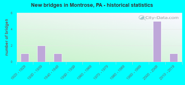
- New bridges - historical statistics
- 11920-1929
- 21930-1939
- 11940-1949
- 52000-2009
- 12010-2019
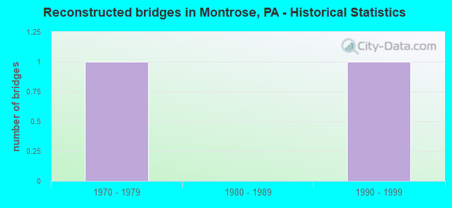
- Reconstructed bridges - Historical Statistics
- 11970-1979
- 01980-1989
- 11990-1999

- Bridge Condition - Deck
- 11.1%Excellent
- 66.7%Good
- 22.2%Poor
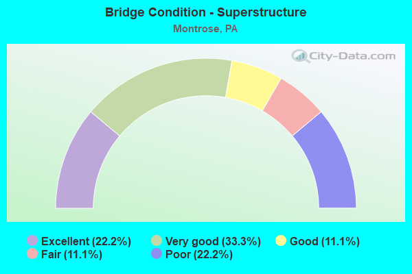
- Bridge Condition - Superstructure
- 22.2%Excellent
- 33.3%Very good
- 11.1%Good
- 11.1%Fair
- 22.2%Poor
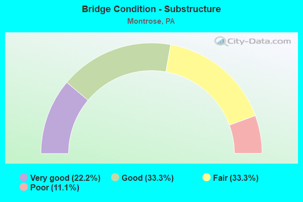
- Bridge Condition - Substructure
- 22.2%Very good
- 33.3%Good
- 33.3%Fair
- 11.1%Poor
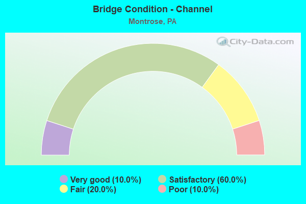
- Bridge Condition - Channel
- 10.0%Very good
- 60.0%Satisfactory
- 20.0%Fair
- 10.0%Poor
Find on map >> Show street view
Structure Number: 32172, Location: FRANKLIN TWP .3M S SR1018 (Lat: 41.880186, Lng: -75.846053), Route carried "on" structure: State highway 29, Year Built: 1933, Year Reconstructed: 1981, Status: Open, Structure Length: 1.65m (5.41ft), Average Daily Traffic: 2,492 (year 2020), Truck Traffic: 10%, Average Future Daily Traffic: 3,830 (year 2032), Design Load: HS 20, Features Intersected: SNAKE CREEK
Minimum Vertical Clearance: 30+ m (98+ ft), Kilometerpoint: 28.810, Lanes on structure: 2, Owner: State Highway Agency, Approaching Roadway Width: 8.5m (27.9ft), Skew: 6 degrees, Material/Design: Prestressed concrete, Design/Construction: Stringer/Multi-beam, Number Of Spans In Main Unit: 1, Length of Maximum Span: 14.9m (48.9ft), Curb or Sidewalk Widths: Left: 0.2m (0.7ft), Right: 0.2m (0.7ft), Curb-To-Curb Width: 11.0m (36.1ft), Out-to-Out Width: 12.0m (39.4ft)
Condition: Deck: Good, Superstructure: Good, Substructure: Fair, Channel: Fair, Operating Rating: 62.6 metric tons, Method Used To Determine Operating Rating: Load Factor (LF), Inventory Rating: 37.2 metric tons, Method Used To Determine Inventory Rating: Load Factor (LF), Structural Evaluation: Somewhat better than minimum adequacy, Deck Geometry: Somewhat better than minimum adequacy, Waterway Adequacy: Equal to present minimum criteria, Approach Roadway Alignment: Better than present minimum criteria, Length Of Structure Improvement: 1.60m (5.25ft), Designated Inspection Frequency: Every 24 months, Inspection Date: May 2020, Bridge Improvement Cost: $12,000, Roadway Improvement Cost: $100,000, Total Project Cost: $164,000, Deck Structure Type: Concrete Cast-file-Place, Wearing Surface/Protective System: Wearing Surface: Monolithic Concrete, Deck Protection: Epoxy Coated Reinforcing
Find on map >> Show street view
Structure Number: 32432, Location: FRANKLIN TWP JCT TR 29 (Lat: 41.884289, Lng: -75.843208), Route carried "on" structure: Spur State highway , Year Built: 1940, Status: Posted for load, Structure Length: 0.79m (2.59ft), Average Daily Traffic: 115 (year 2021), Truck Traffic: 11%, Average Future Daily Traffic: 126 (year 2032), Design Load: HS 20, Features Intersected: SNAKE CREEK, Facility Carried by Structure: SR 1018
Minimum Vertical Clearance: 30+ m (98+ ft), Kilometerpoint: 0.000, Lanes on structure: 2, Owner: State Highway Agency, Approaching Roadway Width: 5.8m (19.0ft), Skew: 1 degrees, Material/Design: Steel, Design/Construction: Stringer/Multi-beam, Number Of Spans In Main Unit: 1, Length of Maximum Span: 7.6m (24.9ft), Curb or Sidewalk Widths: Left: 0.2m (0.7ft), Right: 0.2m (0.7ft), Curb-To-Curb Width: 6.7m (22.0ft), Out-to-Out Width: 7.3m (24.0ft)
Condition: Deck: Poor, Superstructure: Poor, Substructure: Fair, Channel: Satisfactory, Operating Rating: 51.7 metric tons, Method Used To Determine Operating Rating: Load Factor (LF), Inventory Rating: 30.8 metric tons, Method Used To Determine Inventory Rating: Load Factor (LF), Structural Evaluation: Meets minimum limits, Deck Geometry: Meets minimum limits, Waterway Adequacy: Equal to present desirable criteria, Approach Roadway Alignment: Equal to present desirable criteria, Length Of Structure Improvement: 0.80m (2.62ft), Designated Inspection Frequency: Every 24 months, Underwater Inspection Frequency: Every 24 months, Other Special Inspection Frequency: Every 12 months, Inspection Date: September 2021, Underwater Inspection Date: March 2021, Other Special Inspection Date: September 2021, Bridge Improvement Cost: $14,000, Roadway Improvement Cost: $100,000, Total Project Cost: $191,000, Deck Structure Type: Concrete Cast-file-Place, Wearing Surface/Protective System: Wearing Surface: Monolithic Concrete
Find on map >> Show street view
Structure Number: 32555, Location: DIMOCK TWP 1.1M N SR 2026 (Lat: 41.775983, Lng: -75.848289), Route carried "on" structure: State highway , Year Built: 1934, Status: Open, Structure Length: 0.64m (2.10ft), Average Daily Traffic: 417 (year 2020), Truck Traffic: 6%, Average Future Daily Traffic: 436 (year 2032), Design Load: H 20, Features Intersected: JOHNSON POND CREEK, Facility Carried by Structure: SR 2053
Minimum Vertical Clearance: 30+ m (98+ ft), Kilometerpoint: 2.074, Lanes on structure: 2, Owner: State Highway Agency, Approaching Roadway Width: 7.3m (24.0ft), Material/Design: Concrete, Design/Construction: Slab, Number Of Spans In Main Unit: 1, Length of Maximum Span: 6.1m (20.0ft), Curb or Sidewalk Widths: Left: 0.2m (0.7ft), Right: 0.2m (0.7ft), Curb-To-Curb Width: 7.0m (23.0ft), Out-to-Out Width: 7.9m (25.9ft)
Condition: Deck: Poor, Superstructure: Poor, Substructure: Poor, Channel: Poor, Operating Rating: 45.4 metric tons, Method Used To Determine Operating Rating: Field evaluation and documented engineering judgment, Inventory Rating: 29.9 metric tons, Method Used To Determine Inventory Rating: Field evaluation and documented engineering judgment, Structural Evaluation: Meets minimum limits, Deck Geometry: Meets minimum limits, Waterway Adequacy: Better than present minimum criteria, Approach Roadway Alignment: Equal to present desirable criteria, Length Of Structure Improvement: 0.60m (1.97ft), Designated Inspection Frequency: Every 24 months, Inspection Date: January 2020, Bridge Improvement Cost: $18,000, Roadway Improvement Cost: $100,000, Total Project Cost: $245,000, Wearing Surface/Protective System: Wearing Surface: Bituminous
Find on map >> Show street view
Structure Number: 40944, Location: BRDGWTR TWP 1.2M N SR4003 (Lat: 41.889531, Lng: -75.893500), Route carried "on" structure: State highway 167, Year Built: 2000, Status: Open, Structure Length: 0.70m (2.30ft), Average Daily Traffic: 312 (year 2022), Truck Traffic: 11%, Average Future Daily Traffic: 559 (year 2032), Design Load: HS 25 or greater, Features Intersected: BRANCH OF FALL BROOK
Minimum Vertical Clearance: 30+ m (98+ ft), Kilometerpoint: 28.949, Lanes on structure: 2, Owner: State Highway Agency, Approaching Roadway Width: 9.1m (29.9ft), Material/Design: Concrete, Design/Construction: Culvert, Number Of Spans In Main Unit: 1, Length of Maximum Span: 6.4m (21.0ft), Curb-To-Curb Width: 9.7m (31.8ft), Out-to-Out Width: 10.8m (35.4ft)
Condition: Channel: Satisfactory, Culverts: Satisfactory, Operating Rating: 72.6 metric tons, Method Used To Determine Operating Rating: Load Factor (LF), Inventory Rating: 43.5 metric tons, Method Used To Determine Inventory Rating: Load Factor (LF), Structural Evaluation: Equal to present minimum criteria, Deck Geometry: Equal to present minimum criteria, Waterway Adequacy: Better than present minimum criteria, Approach Roadway Alignment: Equal to present desirable criteria, Length Of Structure Improvement: 0.60m (1.97ft), Designated Inspection Frequency: Every 48 months, Inspection Date: April 2020, Wearing Surface/Protective System: Wearing Surface: Bituminous
Find on map >> Show street view
Structure Number: 43232, Location: 1.3 MILES NE OF FAIRDALE (Lat: 41.816428, Lng: -75.938125), Route carried "on" structure: City street , Year Built: 2005, Status: Open, Structure Length: 1.55m (5.09ft), Average Daily Traffic: 50 (year 2011), Truck Traffic: 1%, Average Future Daily Traffic: 75 (year 2031), Features Intersected: E. BR. OF WYALUSING CRK, Facility Carried by Structure: T-684 (HART ROAD)
Minimum Vertical Clearance: 30+ m (98+ ft), Kilometerpoint: 0.000, Lanes on structure: 2, Owner: Town or Township Highway Agency, Approaching Roadway Width: 6.7m (22.0ft), Material/Design: Prestressed concrete, Design/Construction: Box Beam or Girders - Multiple, Number Of Spans In Main Unit: 1, Length of Maximum Span: 15.2m (49.9ft), Curb-To-Curb Width: 6.7m (22.0ft), Out-to-Out Width: 7.7m (25.3ft)
Condition: Deck: Good, Superstructure: Excellent, Substructure: Good, Channel: Satisfactory, Operating Rating: 71.7 metric tons, Method Used To Determine Operating Rating: Load Factor (LF), Inventory Rating: 40.8 metric tons, Method Used To Determine Inventory Rating: Load Factor (LF), Structural Evaluation: Better than present minimum criteria, Deck Geometry: Somewhat better than minimum adequacy, Waterway Adequacy: Better than present minimum criteria, Approach Roadway Alignment: Equal to present minimum criteria, Designated Inspection Frequency: Every 24 months, Inspection Date: July 2019, Deck Structure Type: Concrete Cast-file-Place, Wearing Surface/Protective System: Wearing Surface: Monolithic Concrete, Deck Protection: Epoxy Coated Reinforcing
Find on map >> Show street view
Structure Number: 44914, Location: 4 MILES NORTH OF MONTROSE (Lat: 41.894203, Lng: -75.839414), Route carried "on" structure: City street , Year Built: 2008, Status: Open, Structure Length: 1.13m (3.71ft), Average Daily Traffic: 75 (year 2012), Average Future Daily Traffic: 100 (year 2030), Design Load: HL 93, Features Intersected: SNAKE CREEK, Facility Carried by Structure: T-763 (POTTER RD.)
Minimum Vertical Clearance: 30+ m (98+ ft), Kilometerpoint: 0.000, Lanes on structure: 2, Owner: County Highway Agency, Approaching Roadway Width: 5.5m (18.0ft), Material/Design: Prestressed concrete, Design/Construction: Box Beam or Girders - Single/Spread, Number Of Spans In Main Unit: 1, Length of Maximum Span: 11.0m (36.1ft), Curb-To-Curb Width: 6.7m (22.0ft), Out-to-Out Width: 7.7m (25.3ft)
Condition: Deck: Good, Superstructure: Very good, Substructure: Good, Channel: Satisfactory, Operating Rating: 59.0 metric tons, Method Used To Determine Operating Rating: Load Factor (LF), Inventory Rating: 35.4 metric tons, Method Used To Determine Inventory Rating: Load Factor (LF), Structural Evaluation: Better than present minimum criteria, Deck Geometry: Somewhat better than minimum adequacy, Waterway Adequacy: Better than present minimum criteria, Approach Roadway Alignment: Somewhat better than minimum adequacy, Designated Inspection Frequency: Every 24 months, Inspection Date: July 2020, Deck Structure Type: Concrete Cast-file-Place, Wearing Surface/Protective System: Wearing Surface: Monolithic Concrete, Deck Protection: Epoxy Coated Reinforcing
Find on map >> Show street view
Structure Number: 44919, Location: 2 MILES WEST OF MONTROSE (Lat: 41.820375, Lng: -75.922078), Route carried "on" structure: City street , Year Built: 2008, Status: Open, Structure Length: 1.34m (4.40ft), Average Daily Traffic: 75 (year 2012), Average Future Daily Traffic: 100 (year 2030), Design Load: HL 93, Features Intersected: EAST BR. WYALUSING CREEK, Facility Carried by Structure: T628(FAIR HILL RD)
Minimum Vertical Clearance: 30+ m (98+ ft), Kilometerpoint: 0.000, Lanes on structure: 2, Owner: County Highway Agency, Approaching Roadway Width: 5.5m (18.0ft), Material/Design: Prestressed concrete, Design/Construction: Box Beam or Girders - Single/Spread, Number Of Spans In Main Unit: 1, Length of Maximum Span: 13.1m (43.0ft), Curb-To-Curb Width: 6.1m (20.0ft), Out-to-Out Width: 7.1m (23.3ft)
Condition: Deck: Good, Superstructure: Very good, Substructure: Very good, Channel: Satisfactory, Operating Rating: 55.3 metric tons, Method Used To Determine Operating Rating: Load Factor (LF), Inventory Rating: 32.7 metric tons, Method Used To Determine Inventory Rating: Load Factor (LF), Structural Evaluation: Equal to present desirable criteria, Deck Geometry: Somewhat better than minimum adequacy, Waterway Adequacy: Equal to present desirable criteria, Approach Roadway Alignment: Equal to present desirable criteria, Designated Inspection Frequency: Every 24 months, Inspection Date: July 2020, Deck Structure Type: Concrete Cast-file-Place, Wearing Surface/Protective System: Wearing Surface: Monolithic Concrete, Deck Protection: Epoxy Coated Reinforcing
Find on map >> Show street view
Structure Number: 44946, Location: 3.5 MILES SE OF MONTROSE (Lat: 41.773797, Lng: -75.845811), Route carried "on" structure: City street , Year Built: 2008, Status: Open, Structure Length: 1.19m (3.90ft), Average Daily Traffic: 75 (year 2012), Average Future Daily Traffic: 100 (year 2030), Design Load: HL 93, Features Intersected: MESHOPPEN CREEK, Facility Carried by Structure: T522 (ELY LAKE RD)
Minimum Vertical Clearance: 30+ m (98+ ft), Kilometerpoint: 0.000, Lanes on structure: 2, Owner: County Highway Agency, Approaching Roadway Width: 5.5m (18.0ft), Material/Design: Prestressed concrete, Design/Construction: Box Beam or Girders - Single/Spread, Number Of Spans In Main Unit: 1, Length of Maximum Span: 11.6m (38.1ft), Curb-To-Curb Width: 6.7m (22.0ft), Out-to-Out Width: 7.7m (25.3ft)
Condition: Deck: Good, Superstructure: Very good, Substructure: Good, Channel: Satisfactory, Operating Rating: 67.1 metric tons, Method Used To Determine Operating Rating: Load Factor (LF), Inventory Rating: 34.5 metric tons, Method Used To Determine Inventory Rating: Load Factor (LF), Structural Evaluation: Better than present minimum criteria, Deck Geometry: Somewhat better than minimum adequacy, Waterway Adequacy: Equal to present desirable criteria, Approach Roadway Alignment: Equal to present minimum criteria, Designated Inspection Frequency: Every 24 months, Inspection Date: July 2020, Deck Structure Type: Concrete Cast-file-Place, Wearing Surface/Protective System: Wearing Surface: Monolithic Concrete, Deck Protection: Epoxy Coated Reinforcing
Find on map >> Show street view
Structure Number: 46511, Location: ADJ. TO COLEMAN RD. (Lat: 41.833136, Lng: -75.908828), Route carried "on" structure: City street , Year Built: 1929, Year Reconstructed: 1996, Status: Open, Structure Length: 0.76m (2.49ft), Average Daily Traffic: 225 (year 2011), Average Future Daily Traffic: 300 (year 2031), Design Load: HS 25 or greater, Features Intersected: E. BR. WYALUSING CREEK, Facility Carried by Structure: T726 (BeebeHollow)
Minimum Vertical Clearance: 30+ m (98+ ft), Kilometerpoint: 0.000, Lanes on structure: 2, Owner: Town or Township Highway Agency, Approaching Roadway Width: 6.7m (22.0ft), Material/Design: Concrete, Design/Construction: Tee Beam, Number Of Spans In Main Unit: 1, Length of Maximum Span: 7.3m (24.0ft), Curb or Sidewalk Widths: Left: 0.2m (0.7ft), Right: 0.1m (0.3ft), Curb-To-Curb Width: 7.3m (24.0ft), Out-to-Out Width: 7.9m (25.9ft)
Condition: Deck: Good, Superstructure: Fair, Substructure: Fair, Channel: Fair, Operating Rating: 49.0 metric tons, Method Used To Determine Operating Rating: Field evaluation and documented engineering judgment, Inventory Rating: 32.7 metric tons, Method Used To Determine Inventory Rating: Field evaluation and documented engineering judgment, Structural Evaluation: Somewhat better than minimum adequacy, Deck Geometry: Somewhat better than minimum adequacy, Waterway Adequacy: Better than present minimum criteria, Approach Roadway Alignment: Somewhat better than minimum adequacy, Designated Inspection Frequency: Every 24 months, Inspection Date: May 2021, Deck Structure Type: Concrete Cast-file-Place, Wearing Surface/Protective System: Wearing Surface: Gravel
Find on map >> Show street view
Structure Number: 53626, Location: BRIDGWTR TP 2 M W TR 167 (Lat: 41.824825, Lng: -75.912033), Route carried "on" structure: State highway 706, Year Built: 2016, Status: Open, Structure Length: 1.07m (3.51ft), Average Daily Traffic: 1,872 (year 2022), Truck Traffic: 23%, Average Future Daily Traffic: 2,580 (year 2037), Design Load: HL 93, Features Intersected: PETTIS CREEK
Minimum Vertical Clearance: 30+ m (98+ ft), Kilometerpoint: 20.154, Lanes on structure: 2, Base Highway Network: Yes, Owner: State Highway Agency, Maintenance Responsibility: Private, Approaching Roadway Width: 8.5m (27.9ft), Skew: 1 degrees, Material/Design: Prestressed concrete, Design/Construction: Box Beam or Girders - Single/Spread, Number Of Spans In Main Unit: 1, Length of Maximum Span: 9.8m (32.2ft), Curb-To-Curb Width: 11.0m (36.1ft), Out-to-Out Width: 11.6m (38.1ft)
Condition: Deck: Excellent, Superstructure: Excellent, Substructure: Very good, Channel: Very good, Operating Rating: 62.9 metric tons, Method Used To Determine Operating Rating: Assigned ratings based on Load and Resistance Factor Design (LRFD) reported by rating factor (RF) using HL93 loadings, Inventory Rating: 48.6 metric tons, Method Used To Determine Inventory Rating: Assigned ratings based on Load and Resistance Factor Design (LRFD) reported by rating factor (RF) using HL93 loadings, Structural Evaluation: Equal to present desirable criteria, Deck Geometry: Equal to present minimum criteria, Waterway Adequacy: Equal to present desirable criteria, Approach Roadway Alignment: Equal to present desirable criteria, Designated Inspection Frequency: Every 24 months, Inspection Date: May 2020, Deck Structure Type: Concrete Cast-file-Place, Wearing Surface/Protective System: Wearing Surface: Integral Concrete, Deck Protection: Epoxy Coated Reinforcing