Bridge Statistics for Montrose, Virginia (VA)
Condition, Traffic, Stress, Structural Evaluation, Project Costs
- National Bridge Inventory (NBI) Statistics
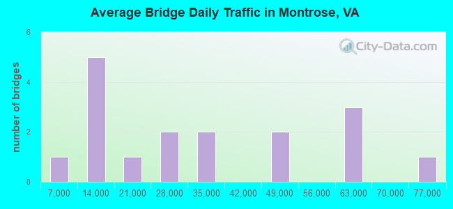
- 17Number of bridges
- 249ft / 75.8mTotal length
- $1,807,000Total costs
- 524,666Total average daily traffic
- 17,284Total average daily truck traffic
- National Bridge Inventory (NBI) Registered Bridges for Montrose
- No street view available for this location
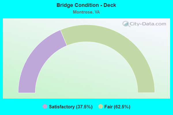
- Bridge Condition - Deck
- 37.5%Satisfactory
- 62.5%Fair
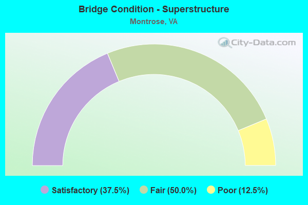
- Bridge Condition - Superstructure
- 37.5%Satisfactory
- 50.0%Fair
- 12.5%Poor
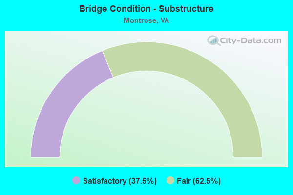
- Bridge Condition - Substructure
- 37.5%Satisfactory
- 62.5%Fair
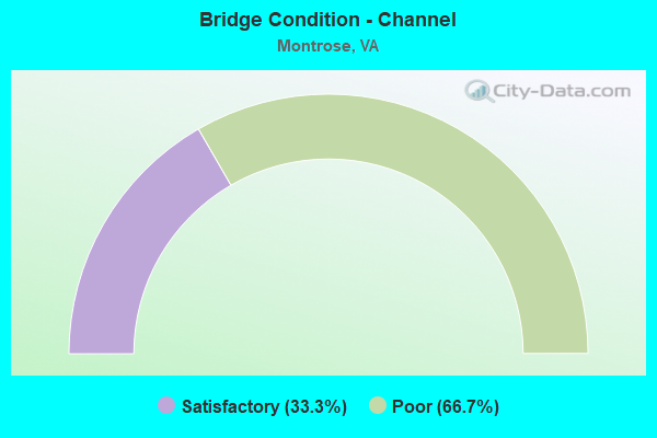
- Bridge Condition - Channel
- 33.3%Satisfactory
- 66.7%Poor
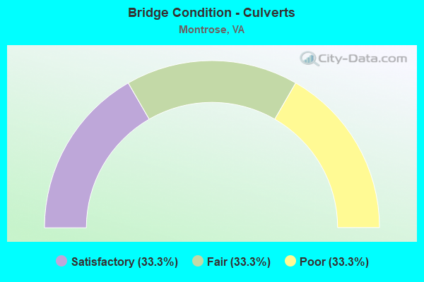
- Bridge Condition - Culverts
- 33.3%Satisfactory
- 33.3%Fair
- 33.3%Poor
Find on map >> Show street view
Structure Number: 9608, Location: 0.64RICHM RD 0.25 TO 33 (Lat: 37.538469, Lng: -77.386711), Route carried "on" structure: County highway , Year Built: 1968, Status: Open, Structure Length: 8.04m (26.38ft), Average Daily Traffic: 650 (year 1987), Truck Traffic: 1%, Average Future Daily Traffic: 910 (year 2028), Design Load: HS 20+Mod, Features Intersected: ROUTE 0064, Facility Carried by Structure: STONEY RUN PKWY
Minimum Vertical Clearance: 30+ m (98+ ft), Kilometerpoint: 0.000, Lanes on structure: 2, Lanes under structure: 6, Owner: State Highway Agency, Approaching Roadway Width: 10.7m (35.1ft), Material/Design: Prestressed concrete, Design/Construction: Stringer/Multi-beam, Number Of Spans In Main Unit: 4, Length of Maximum Span: 21.6m (70.9ft), Curb-To-Curb Width: 10.8m (35.4ft), Out-to-Out Width: 11.8m (38.7ft)
Condition: Deck: Satisfactory, Superstructure: Satisfactory, Substructure: Satisfactory, Operating Rating: 64.4 metric tons, Method Used To Determine Operating Rating: Load Factor (LF), Inventory Rating: 35.4 metric tons, Method Used To Determine Inventory Rating: Load Factor (LF), Structural Evaluation: Equal to present minimum criteria, Deck Geometry: Equal to present minimum criteria, Underclear: Equal to present minimum criteria, Approach Roadway Alignment: Better than present minimum criteria, Designated Inspection Frequency: Every 24 months, Inspection Date: April 2020, Deck Structure Type: Concrete Cast-file-Place, Wearing Surface/Protective System: Deck Protection: Epoxy Coated Reinforcing
Find on map >> Show street view
Structure Number: 9624, Location: 0.25GAY AVE 0.4N THORNH (Lat: 37.531550, Lng: -77.360956), Route carried "on" structure: County highway 7555, Year Built: 1964, Year Reconstructed: 1997, Status: Open, Structure Length: 9.45m (31.00ft), Average Daily Traffic: 11,602 (year 2020), Truck Traffic: 2%, Average Future Daily Traffic: 16,243 (year 2040), Design Load: HS 20+Mod, Features Intersected: ROUTE 0064, Facility Carried by Structure: SBL LABURNUM AVE
Minimum Vertical Clearance: 30+ m (98+ ft), Kilometerpoint: 8.914, Lanes on structure: 2, Lanes under structure: 7, Base Highway Network: Yes, Owner: State Highway Agency, Approaching Roadway Width: 10.4m (34.1ft), Skew: 2 degrees, Material/Design: Steel continuous, Design/Construction: Stringer/Multi-beam, Number Of Spans In Main Unit: 4, Length of Maximum Span: 28.0m (91.9ft), Curb or Sidewalk Widths: Left: 1.5m (4.9ft), Right: 0.5m (1.6ft), Curb-To-Curb Width: 8.8m (28.9ft), Out-to-Out Width: 11.5m (37.7ft)
Condition: Deck: Satisfactory, Superstructure: Satisfactory, Substructure: Satisfactory, Operating Rating: 50.8 metric tons, Method Used To Determine Operating Rating: Load and Resistance Factor (LRFR), Inventory Rating: 39.0 metric tons, Method Used To Determine Inventory Rating: Load and Resistance Factor (LRFR), Structural Evaluation: Equal to present minimum criteria, Deck Geometry: High priority of corrective action, Underclear: Equal to present minimum criteria, Approach Roadway Alignment: Equal to present desirable criteria, Length Of Structure Improvement: 9.45m (31.00ft), Designated Inspection Frequency: Every 24 months, Inspection Date: Febuary 2021, Bridge Improvement Cost: $390,000, Roadway Improvement Cost: $100,000, Total Project Cost: $588,000, Deck Structure Type: Concrete Cast-file-Place, Wearing Surface/Protective System: Wearing Surface: Latex Concrete
Find on map >> Show street view
Structure Number: 9626, Location: 0.25GAY AVE 0.4N THORNH (Lat: 37.531581, Lng: -77.360756), Route carried "on" structure: County highway 7555, Year Built: 1964, Year Reconstructed: 1997, Status: Open, Structure Length: 9.45m (31.00ft), Average Daily Traffic: 11,602 (year 2020), Truck Traffic: 2%, Average Future Daily Traffic: 16,243 (year 2040), Design Load: HS 20+Mod, Features Intersected: ROUTE 0064, Facility Carried by Structure: NBL LABURNUM AVE
Minimum Vertical Clearance: 30+ m (98+ ft), Kilometerpoint: 8.914, Lanes on structure: 3, Lanes under structure: 7, Base Highway Network: Yes, Owner: State Highway Agency, Approaching Roadway Width: 11.6m (38.1ft), Skew: 2 degrees, Material/Design: Steel continuous, Design/Construction: Stringer/Multi-beam, Number Of Spans In Main Unit: 4, Length of Maximum Span: 28.0m (91.9ft), Curb-To-Curb Width: 11.6m (38.1ft), Out-to-Out Width: 12.6m (41.3ft)
Condition: Deck: Satisfactory, Superstructure: Satisfactory, Substructure: Satisfactory, Operating Rating: 50.8 metric tons, Method Used To Determine Operating Rating: Load and Resistance Factor (LRFR), Inventory Rating: 39.0 metric tons, Method Used To Determine Inventory Rating: Load and Resistance Factor (LRFR), Structural Evaluation: Equal to present minimum criteria, Deck Geometry: High priority of replacement, Underclear: Equal to present minimum criteria, Approach Roadway Alignment: Equal to present desirable criteria, Length Of Structure Improvement: 9.45m (31.00ft), Designated Inspection Frequency: Every 24 months, Inspection Date: Febuary 2021, Bridge Improvement Cost: $390,000, Roadway Improvement Cost: $100,000, Total Project Cost: $588,000, Deck Structure Type: Concrete Cast-file-Place, Wearing Surface/Protective System: Wearing Surface: Latex Concrete, Deck Protection: Epoxy Coated Reinforcing
Find on map >> Show street view
Structure Number: 9745, Location: .12 ECL RICH.65 DAB HOUSE (Lat: 37.544153, Lng: -77.394039), Route carried "on" structure: State highway 33, Year Built: 1968, Status: Open, Structure Length: 10.76m (35.30ft), Average Daily Traffic: 19,000 (year 2021), Truck Traffic: 2%, Average Future Daily Traffic: 22,613 (year 2040), Design Load: HS 20+Mod, Features Intersected: I-64, Facility Carried by Structure: NINE MILE ROAD
Minimum Vertical Clearance: 30+ m (98+ ft), Kilometerpoint: 5.734, Lanes on structure: 6, Lanes under structure: 8, Owner: State Highway Agency, Approaching Roadway Width: 23.8m (78.1ft), Skew: 23 degrees, Material/Design: Steel, Design/Construction: Stringer/Multi-beam, Number Of Spans In Main Unit: 4, Length of Maximum Span: 32.9m (107.9ft), Curb or Sidewalk Widths: Left: 1.5m (4.9ft), Right: 1.5m (4.9ft), Curb-To-Curb Width: 28.7m (94.2ft), Out-to-Out Width: 32.4m (106.3ft)
Condition: Deck: Fair, Superstructure: Poor, Substructure: Fair, Operating Rating: 51.7 metric tons, Method Used To Determine Operating Rating: Load and Resistance Factor (LRFR), Inventory Rating: 39.9 metric tons, Method Used To Determine Inventory Rating: Load and Resistance Factor (LRFR), Structural Evaluation: Meets minimum limits, Deck Geometry: Superior to present desirable criteria, Underclear: Equal to present minimum criteria, Approach Roadway Alignment: Equal to present desirable criteria, Length Of Structure Improvement: 10.67m (35.01ft), Designated Inspection Frequency: Every 12 months, Inspection Date: November 2021, Bridge Improvement Cost: $466,000, Roadway Improvement Cost: $1,000, Total Project Cost: $607,000, Deck Structure Type: Concrete Cast-file-Place, Wearing Surface/Protective System: Wearing Surface: Bituminous
Find on map >> Show street view
Structure Number: 9796, Location: 1.43 TO 33 & 0.8 LABUR AV (Lat: 37.530200, Lng: -77.374731), Route carried "on" structure: Interstate 64, Year Built: 1968, Status: Open, Structure Length: 1.38m (4.53ft), Average Daily Traffic: 56,714 (year 2020), Truck Traffic: 4%, Average Future Daily Traffic: 57,694 (year 2040), Design Load: HS 20, Features Intersected: GILLIES CREEK
Minimum Vertical Clearance: 30+ m (98+ ft), Kilometerpoint: 313.755, Lanes on structure: 6, Base Highway Network: Yes, Owner: State Highway Agency, Approaching Roadway Width: 29.9m (98.1ft), Skew: 22 degrees, Material/Design: Concrete, Design/Construction: Culvert, Number Of Spans In Main Unit: 4, Length of Maximum Span: 3.1m (10.2ft)
Condition: Channel: Poor, Culverts: Fair, Operating Rating: 89.8 metric tons, Method Used To Determine Operating Rating: Field evaluation and documented engineering judgment, Inventory Rating: 89.8 metric tons, Method Used To Determine Inventory Rating: Field evaluation and documented engineering judgment, Structural Evaluation: Somewhat better than minimum adequacy, Waterway Adequacy: Equal to present desirable criteria, Approach Roadway Alignment: Equal to present desirable criteria, Designated Inspection Frequency: Every 24 months, Inspection Date: October 2021
Find on map >> Show street view
Structure Number: 9803, Location: .36 TO 33 & 1.82 LABURNUM (Lat: 37.540614, Lng: -77.389008), Route carried "on" structure: Interstate 64, Year Built: 1968, Status: Open, Structure Length: 1.04m (3.41ft), Average Daily Traffic: 56,714 (year 2020), Truck Traffic: 4%, Average Future Daily Traffic: 57,694 (year 2040), Design Load: HS 20, Features Intersected: STONY RUN
Minimum Vertical Clearance: 30+ m (98+ ft), Kilometerpoint: 312.371, Lanes on structure: 6, Base Highway Network: Yes, Owner: State Highway Agency, Approaching Roadway Width: 29.9m (98.1ft), Skew: 22 degrees, Material/Design: Concrete, Design/Construction: Culvert, Number Of Spans In Main Unit: 4, Length of Maximum Span: 2.4m (7.9ft)
Condition: Channel: Poor, Culverts: Poor, Operating Rating: 89.8 metric tons, Method Used To Determine Operating Rating: Field evaluation and documented engineering judgment, Inventory Rating: 89.8 metric tons, Method Used To Determine Inventory Rating: Field evaluation and documented engineering judgment, Structural Evaluation: Meets minimum limits, Waterway Adequacy: Equal to present minimum criteria, Approach Roadway Alignment: Equal to present desirable criteria, Designated Inspection Frequency: Every 12 months, Inspection Date: March 2021
Find on map >> Show street view
Structure Number: 9804, Location: 1.36 TO 33/.85 FR LAB AV (Lat: 37.530586, Lng: -77.375803), Route carried "on" structure: Interstate 64, Year Built: 1968, Status: Open, Structure Length: 5.87m (19.26ft), Average Daily Traffic: 28,944 (year 2020), Truck Traffic: 4%, Average Future Daily Traffic: 40,522 (year 2040), Design Load: HS 20+Mod, Features Intersected: MASONIC LANE
Minimum Vertical Clearance: 30+ m (98+ ft), Kilometerpoint: 314.029, Lanes on structure: 3, Lanes under structure: 2, Base Highway Network: Yes, Owner: State Highway Agency, Approaching Roadway Width: 17.1m (56.1ft), Skew: 2 degrees, Material/Design: Prestressed concrete, Design/Construction: Stringer/Multi-beam, Number Of Spans In Main Unit: 3, Length of Maximum Span: 21.6m (70.9ft), Curb-To-Curb Width: 15.8m (51.8ft), Out-to-Out Width: 16.5m (54.1ft)
Condition: Deck: Fair, Superstructure: Fair, Substructure: Fair, Operating Rating: 78.0 metric tons, Method Used To Determine Operating Rating: Load Factor (LF), Inventory Rating: 42.6 metric tons, Method Used To Determine Inventory Rating: Load Factor (LF), Structural Evaluation: Somewhat better than minimum adequacy, Deck Geometry: Somewhat better than minimum adequacy, Underclear: Meets minimum limits, Approach Roadway Alignment: Equal to present desirable criteria, Length Of Structure Improvement: 5.79m (19.00ft), Designated Inspection Frequency: Every 24 months, Inspection Date: August 2020, Bridge Improvement Cost: $1,000, Roadway Improvement Cost: $10,000, Total Project Cost: $12,000, Deck Structure Type: Concrete Cast-file-Place, Wearing Surface/Protective System: Wearing Surface: Bituminous, Membrane: Preformed Fabric
Find on map >> Show street view
Structure Number: 9806, Location: 1.35 TO 33/ .84 FR LAB AV (Lat: 37.530822, Lng: -77.375764), Route carried "on" structure: Interstate 64, Year Built: 1968, Status: Open, Structure Length: 5.58m (18.31ft), Average Daily Traffic: 27,770 (year 2020), Truck Traffic: 4%, Average Future Daily Traffic: 38,878 (year 2040), Design Load: HS 20+Mod, Features Intersected: MASONIC LANE
Minimum Vertical Clearance: 30+ m (98+ ft), Kilometerpoint: 314.029, Lanes on structure: 3, Lanes under structure: 2, Base Highway Network: Yes, Owner: State Highway Agency, Approaching Roadway Width: 17.1m (56.1ft), Skew: 2 degrees, Material/Design: Prestressed concrete, Design/Construction: Stringer/Multi-beam, Number Of Spans In Main Unit: 3, Length of Maximum Span: 21.6m (70.9ft), Curb-To-Curb Width: 15.8m (51.8ft), Out-to-Out Width: 16.5m (54.1ft)
Condition: Deck: Fair, Superstructure: Fair, Substructure: Fair, Operating Rating: 78.0 metric tons, Method Used To Determine Operating Rating: Load Factor (LF), Inventory Rating: 43.5 metric tons, Method Used To Determine Inventory Rating: Load Factor (LF), Structural Evaluation: Somewhat better than minimum adequacy, Deck Geometry: Somewhat better than minimum adequacy, Underclear: Meets minimum limits, Approach Roadway Alignment: Equal to present desirable criteria, Length Of Structure Improvement: 5.79m (19.00ft), Designated Inspection Frequency: Every 24 months, Inspection Date: August 2020, Bridge Improvement Cost: $1,000, Roadway Improvement Cost: $10,000, Total Project Cost: $12,000, Deck Structure Type: Concrete Cast-file-Place, Wearing Surface/Protective System: Wearing Surface: Bituminous, Membrane: Preformed Fabric
Find on map >> Show street view
Structure Number: 9808, Location: 1.47 FR 33 & 0.74LABUR AV (Lat: 37.529964, Lng: -77.373875), Route carried "on" structure: Interstate 64, Year Built: 1968, Status: Open, Structure Length: 11.49m (37.70ft), Average Daily Traffic: 28,944 (year 2020), Truck Traffic: 4%, Average Future Daily Traffic: 40,522 (year 2040), Design Load: HS 20+Mod, Features Intersected: NORFOLK SOUTHERN RWY
Minimum Vertical Clearance: 30+ m (98+ ft), Kilometerpoint: 314.206, Lanes on structure: 3, Base Highway Network: Yes, Owner: State Highway Agency, Approaching Roadway Width: 17.1m (56.1ft), Skew: 6 degrees, Material/Design: Steel, Design/Construction: Stringer/Multi-beam, Number Of Spans In Main Unit: 5, Length of Maximum Span: 30.6m (100.4ft), Curb or Sidewalk Widths: Left: 0.5m (1.6ft), Right: 0.5m (1.6ft), Curb-To-Curb Width: 12.8m (42.0ft), Out-to-Out Width: 14.3m (46.9ft)
Condition: Deck: Fair, Superstructure: Fair, Substructure: Fair, Operating Rating: 42.7 metric tons, Method Used To Determine Operating Rating: Load and Resistance Factor (LRFR), Inventory Rating: 33.0 metric tons, Method Used To Determine Inventory Rating: Load and Resistance Factor (LRFR), Structural Evaluation: Somewhat better than minimum adequacy, Deck Geometry: Meets minimum limits, Underclear: Equal to present minimum criteria, Approach Roadway Alignment: Equal to present desirable criteria, Designated Inspection Frequency: Every 24 months, Inspection Date: October 2021, Deck Structure Type: Concrete Cast-file-Place, Wearing Surface/Protective System: Wearing Surface: Bituminous, Membrane: Preformed Fabric
Find on map >> Show street view
Structure Number: 9809, Location: 1.5 FR 33 & 0.69LABUR AV (Lat: 37.530100, Lng: -77.373389), Route carried "on" structure: Interstate 64, Year Built: 1968, Status: Open, Structure Length: 11.49m (37.70ft), Average Daily Traffic: 27,770 (year 2020), Truck Traffic: 4%, Average Future Daily Traffic: 38,878 (year 2040), Design Load: HS 20+Mod, Features Intersected: NORFOLK SOUTHERN RWY
Minimum Vertical Clearance: 30+ m (98+ ft), Kilometerpoint: 314.270, Lanes on structure: 3, Base Highway Network: Yes, Owner: State Highway Agency, Approaching Roadway Width: 17.1m (56.1ft), Skew: 6 degrees, Material/Design: Steel, Design/Construction: Stringer/Multi-beam, Number Of Spans In Main Unit: 5, Length of Maximum Span: 30.6m (100.4ft), Curb or Sidewalk Widths: Left: 0.5m (1.6ft), Right: 0.5m (1.6ft), Curb-To-Curb Width: 12.8m (42.0ft), Out-to-Out Width: 14.3m (46.9ft)
Condition: Deck: Fair, Superstructure: Fair, Substructure: Fair, Operating Rating: 52.6 metric tons, Method Used To Determine Operating Rating: Load and Resistance Factor (LRFR), Inventory Rating: 40.6 metric tons, Method Used To Determine Inventory Rating: Load and Resistance Factor (LRFR), Structural Evaluation: Somewhat better than minimum adequacy, Deck Geometry: Meets minimum limits, Underclear: Equal to present minimum criteria, Approach Roadway Alignment: Equal to present desirable criteria, Designated Inspection Frequency: Every 24 months, Inspection Date: October 2021, Deck Structure Type: Concrete Cast-file-Place, Wearing Surface/Protective System: Wearing Surface: Bituminous, Membrane: Preformed Fabric
Find on map >> Show street view
Structure Number: 30652, Location: 0.3 GAY AVE 0.4 8th ST (Lat: 37.530000, Lng: -77.375000), Route carried "on" structure: County highway 75370, Year Built: 1965, Status: Open, Structure Length: 1.28m (4.20ft), Average Daily Traffic: 9,445 (year 2020), Truck Traffic: 4%, Average Future Daily Traffic: 11,137 (year 2040), Design Load: HS 20, Features Intersected: GILLIES CREEK, Facility Carried by Structure: MASONIC LANE
Minimum Vertical Clearance: 30.45m (99.90ft), Kilometerpoint: 0.000, Lanes on structure: 2, Owner: County Highway Agency, Approaching Roadway Width: 14.0m (45.9ft), Material/Design: Concrete, Design/Construction: Culvert, Number Of Spans In Main Unit: 4, Length of Maximum Span: 3.0m (9.8ft)
Condition: Channel: Satisfactory, Culverts: Satisfactory, Operating Rating: 54.4 metric tons, Method Used To Determine Operating Rating: Field evaluation and documented engineering judgment, Inventory Rating: 32.7 metric tons, Method Used To Determine Inventory Rating: Field evaluation and documented engineering judgment, Structural Evaluation: Equal to present minimum criteria, Waterway Adequacy: Equal to present desirable criteria, Approach Roadway Alignment: Equal to present desirable criteria, Designated Inspection Frequency: Every 24 months, Inspection Date: August 2021
Find on map >> Show street view
Structure Number: 9608, Location: 0.64RICHM RD 0.25 TO 33 (Lat: 37.538469, Lng: -77.386711), Route carried "under" structure: Interstate 64, Year Built: 1968, Structure Length: 0. m, Average Daily Traffic: 56,883 (year 2008), Truck Traffic: 2%, Features Intersected: ROUTE 0064, Facility Carried by Structure: STONEY RUN PKWY
Minimum Vertical Clearance: 5.28m (17.32ft), Kilometerpoint: 312.951, Lanes on structure: 2, Lanes under structure: 6, Material/Design: Prestressed concrete, Design/Construction: Stringer/Multi-beam, Length of Maximum Span: 21.6m (70.9ft)
Find on map >> Show street view
Structure Number: 9624, Location: 0.25GAY AVE 0.4N THORNH (Lat: 37.531550, Lng: -77.360956), Route carried "under" structure: Interstate 64, Year Built: 1964, Structure Length: 0. m, Average Daily Traffic: 47,475 (year 2008), Truck Traffic: 2%, Features Intersected: ROUTE 0064, Facility Carried by Structure: SBL LABURNUM AVE
Minimum Vertical Clearance: 5.66m (18.57ft), Kilometerpoint: 315.284, Lanes on structure: 2, Lanes under structure: 7, Material/Design: Steel continuous, Design/Construction: Stringer/Multi-beam, Length of Maximum Span: 28.0m (91.9ft)
Find on map >> Show street view
Structure Number: 9626, Location: 0.25GAY AVE 0.4N THORNH (Lat: 37.531581, Lng: -77.360756), Route carried "under" structure: Interstate 64, Year Built: 1964, Structure Length: 0. m, Average Daily Traffic: 47,475 (year 2008), Truck Traffic: 2%, Features Intersected: ROUTE 0064, Facility Carried by Structure: NBL LABURNUM AVE
Minimum Vertical Clearance: 5.51m (18.08ft), Kilometerpoint: 315.300, Lanes on structure: 3, Lanes under structure: 7, Material/Design: Steel continuous, Design/Construction: Stringer/Multi-beam, Length of Maximum Span: 28.0m (91.9ft)
Find on map >> Show street view
Structure Number: 9745, Location: .12 ECL RICH.65 DAB HOUSE (Lat: 37.544153, Lng: -77.394039), Route carried "under" structure: Interstate 64, Year Built: 1968, Structure Length: 0. m, Average Daily Traffic: 73,000 (year 2020), Truck Traffic: 4%, Features Intersected: I-64, Facility Carried by Structure: NINE MILE ROAD
Minimum Vertical Clearance: 5.18m (16.99ft), Kilometerpoint: 311.872, Lanes on structure: 6, Lanes under structure: 8, Material/Design: Steel, Design/Construction: Stringer/Multi-beam, Length of Maximum Span: 32.9m (107.9ft)
Find on map >> Show street view
Structure Number: 9804, Location: 1.36 TO 33/.85 FR LAB AV (Lat: 37.530586, Lng: -77.375803), Route carried "under" structure: County highway , Year Built: 1968, Structure Length: 0. m, Average Daily Traffic: 10,339 (year 2008), Truck Traffic: 5%, Features Intersected: MASONIC LANE, Facility Carried by Structure: EBL i-64
Minimum Vertical Clearance: 6.30m (20.67ft), Kilometerpoint: 1.142, Lanes on structure: 3, Lanes under structure: 2, Material/Design: Prestressed concrete, Design/Construction: Stringer/Multi-beam, Length of Maximum Span: 21.6m (70.9ft)
Find on map >> Show street view
Structure Number: 9806, Location: 1.35 TO 33/ .84 FR LAB AV (Lat: 37.530822, Lng: -77.375764), Route carried "under" structure: County highway , Year Built: 1968, Structure Length: 0. m, Average Daily Traffic: 10,339 (year 2008), Truck Traffic: 5%, Features Intersected: MASONIC LANE, Facility Carried by Structure: WBL I-64
Minimum Vertical Clearance: 5.31m (17.42ft), Kilometerpoint: 1.142, Lanes on structure: 3, Lanes under structure: 2, Material/Design: Prestressed concrete, Design/Construction: Stringer/Multi-beam, Length of Maximum Span: 21.6m (70.9ft)