Bridge Statistics for Moorefield, West Virginia (WV)
Condition, Traffic, Stress, Structural Evaluation, Project Costs
- National Bridge Inventory (NBI) Statistics
- 32Number of bridges
- 614ft / 187mTotal length
- $1,126,000Total costs
- 83,833Total average daily traffic
- 7,434Total average daily truck traffic
- National Bridge Inventory (NBI) Registered Bridges for Moorefield
- No street view available for this location
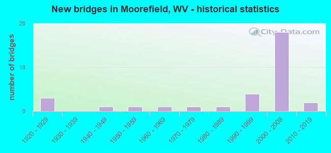
- New bridges - historical statistics
- 31920-1929
- 11940-1949
- 11950-1959
- 11960-1969
- 11970-1979
- 11980-1989
- 41990-1999
- 182000-2009
- 22010-2019
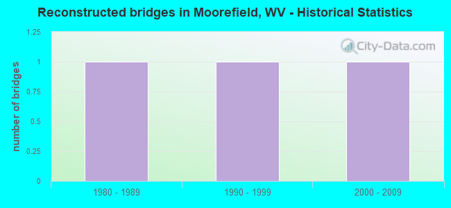
- Reconstructed bridges - Historical Statistics
- 11980-1989
- 11990-1999
- 12000-2009
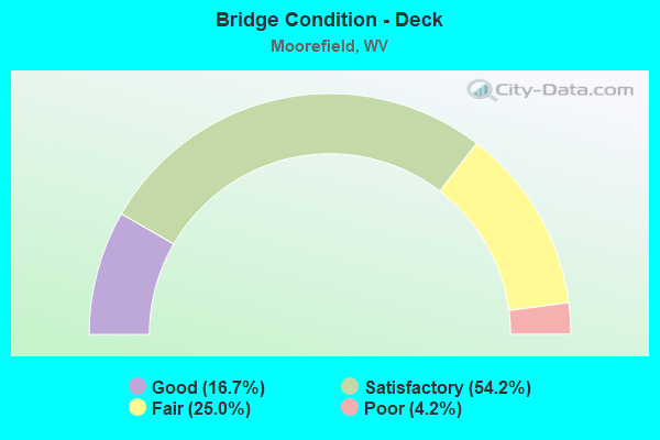
- Bridge Condition - Deck
- 16.7%Good
- 54.2%Satisfactory
- 25.0%Fair
- 4.2%Poor
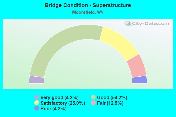
- Bridge Condition - Superstructure
- 4.2%Very good
- 54.2%Good
- 25.0%Satisfactory
- 12.5%Fair
- 4.2%Poor
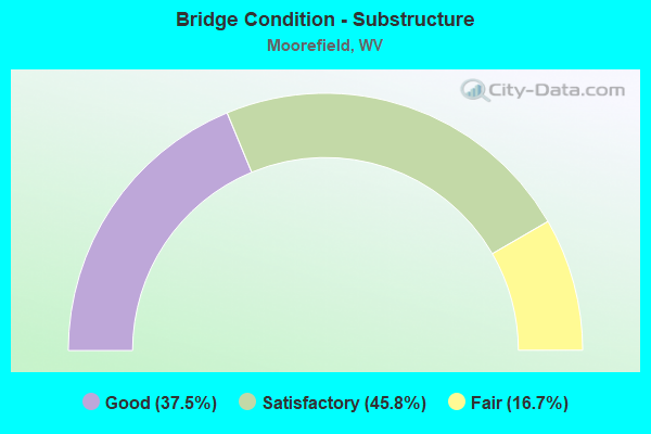
- Bridge Condition - Substructure
- 37.5%Good
- 45.8%Satisfactory
- 16.7%Fair
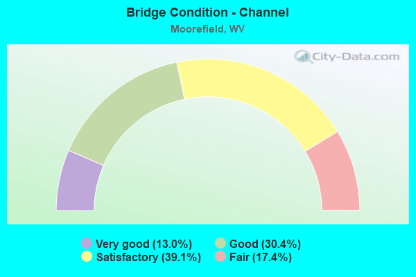
- Bridge Condition - Channel
- 13.0%Very good
- 30.4%Good
- 39.1%Satisfactory
- 17.4%Fair
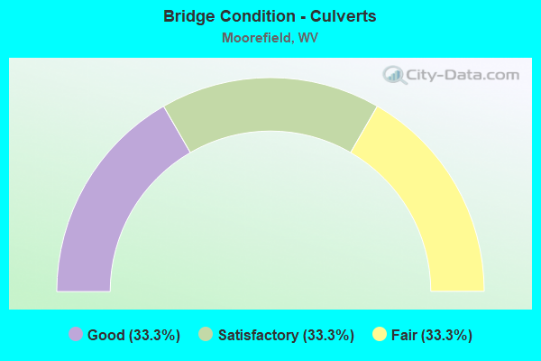
- Bridge Condition - Culverts
- 33.3%Good
- 33.3%Satisfactory
- 33.3%Fair
Find on map >> Show street view
Structure Number: 16A01, Location: 0.21 MI N OF US 220 F (Lat: 39.097650, Lng: -78.955169), Route carried "on" structure: County highway 401, Year Built: 1927, Status: Posted for load, Structure Length: 0.86m (2.82ft), Average Daily Traffic: 1,100 (year 2020), Truck Traffic: 8%, Average Future Daily Traffic: 1,166 (year 2040), Features Intersected: FORT RUN, Facility Carried by Structure: C.R. 4/1 SLS
Minimum Vertical Clearance: 30+ m (98+ ft), Kilometerpoint: 0.338, Lanes on structure: 2, Owner: State Highway Agency, Approaching Roadway Width: 8.5m (27.9ft), Material/Design: Concrete continuous, Design/Construction: Slab, Number Of Spans In Main Unit: 2, Length of Maximum Span: 3.9m (12.8ft), Curb-To-Curb Width: 7.1m (23.3ft), Out-to-Out Width: 8.1m (26.6ft)
Condition: Deck: Poor, Superstructure: Poor, Substructure: Fair, Channel: Fair, Operating Rating: 42.6 metric tons, Method Used To Determine Operating Rating: Field evaluation and documented engineering judgment, Inventory Rating: 20.0 metric tons, Method Used To Determine Inventory Rating: Field evaluation and documented engineering judgment, Structural Evaluation: Meets minimum limits, Deck Geometry: High priority of corrective action, Waterway Adequacy: Equal to present minimum criteria, Approach Roadway Alignment: Better than present minimum criteria, Length Of Structure Improvement: 0.85m (2.79ft), Designated Inspection Frequency: Every 24 months, Inspection Date: November 2021, Bridge Improvement Cost: $50,000, Roadway Improvement Cost: $1,000, Total Project Cost: $51,000 ( Estimate for 2015), Deck Structure Type: Concrete Cast-file-Place, Wearing Surface/Protective System: Wearing Surface: Bituminous
Find on map >> Show street view
Structure Number: 16A02, Location: 0.37 MI S OF CR 12 F (Lat: 39.007269, Lng: -78.953411), Route carried "on" structure: County highway 700, Year Built: 1947, Status: Open, Structure Length: 1.18m (3.87ft), Average Daily Traffic: 800 (year 2019), Truck Traffic: 5%, Average Future Daily Traffic: 1,040 (year 2039), Features Intersected: STONY RUN, Facility Carried by Structure: CR 07 SLS
Minimum Vertical Clearance: 30+ m (98+ ft), Kilometerpoint: 28.276, Lanes on structure: 2, Owner: State Highway Agency, Approaching Roadway Width: 8.5m (27.9ft), Material/Design: Steel, Design/Construction: Culvert, Number Of Spans In Main Unit: 2, Length of Maximum Span: 5.5m (18.0ft)
Condition: Channel: Fair, Culverts: Fair, Operating Rating: 53.5 metric tons, Method Used To Determine Operating Rating: Field evaluation and documented engineering judgment, Inventory Rating: 24.5 metric tons, Method Used To Determine Inventory Rating: Field evaluation and documented engineering judgment, Structural Evaluation: Somewhat better than minimum adequacy, Waterway Adequacy: Equal to present minimum criteria, Approach Roadway Alignment: Better than present minimum criteria, Length Of Structure Improvement: 1.16m (3.81ft), Designated Inspection Frequency: Every 24 months, Inspection Date: November 2020, Bridge Improvement Cost: $300,000, Roadway Improvement Cost: $25,000, Total Project Cost: $325,000 ( Estimate for 2014)
Find on map >> Show street view
Structure Number: 16A024, Location: 0.65 MI S OF CR 10/4 SLS (Lat: 39.060881, Lng: -79.022489), Route carried "on" structure: County highway 1000, Year Built: 1991, Status: Open, Structure Length: 1.21m (3.97ft), Average Daily Traffic: 1,622 (year 2017), Truck Traffic: 6%, Average Future Daily Traffic: 2,190 (year 2037), Design Load: HS 25 or greater, Features Intersected: BRANCH HUTTON RUN, Facility Carried by Structure: CR 10 SLS
Minimum Vertical Clearance: 30+ m (98+ ft), Kilometerpoint: 11.378, Lanes on structure: 2, Owner: State Highway Agency, Approaching Roadway Width: 8.5m (27.9ft), Skew: 3 degrees, Material/Design: Prestressed concrete, Design/Construction: Box Beam or Girders - Multiple, Number Of Spans In Main Unit: 1, Length of Maximum Span: 10.9m (35.8ft), Curb-To-Curb Width: 8.0m (26.2ft), Out-to-Out Width: 8.2m (26.9ft)
Condition: Deck: Satisfactory, Superstructure: Satisfactory, Substructure: Satisfactory, Channel: Satisfactory, Operating Rating: 88.9 metric tons, Method Used To Determine Operating Rating: Load Factor (LF), Inventory Rating: 55.3 metric tons, Method Used To Determine Inventory Rating: Load Factor (LF), Structural Evaluation: Equal to present minimum criteria, Deck Geometry: Meets minimum limits, Waterway Adequacy: Equal to present desirable criteria, Approach Roadway Alignment: Equal to present desirable criteria, Designated Inspection Frequency: Every 48 months, Inspection Date: January 2019, Deck Structure Type: Other, Wearing Surface/Protective System: Wearing Surface: Bituminous, Deck Protection: Epoxy Coated Reinforcing
Find on map >> Show street view
Structure Number: 16A025, Location: 0.41 MI N OF CR 13 SLS (Lat: 39.056339, Lng: -78.999431), Route carried "on" structure: County highway 1003, Year Built: 1968, Year Reconstructed: 2000, Status: Open, Structure Length: 0.99m (3.25ft), Average Daily Traffic: 350 (year 2018), Truck Traffic: 5%, Average Future Daily Traffic: 466 (year 2038), Design Load: HS 25 or greater, Features Intersected: HUTTER RUN, Facility Carried by Structure: CR 10/3 SLS
Minimum Vertical Clearance: 30+ m (98+ ft), Kilometerpoint: 0.998, Lanes on structure: 2, Owner: State Highway Agency, Approaching Roadway Width: 4.9m (16.1ft), Material/Design: Steel, Design/Construction: Stringer/Multi-beam, Number Of Spans In Main Unit: 1, Length of Maximum Span: 8.9m (29.2ft), Curb-To-Curb Width: 7.0m (23.0ft), Out-to-Out Width: 7.1m (23.3ft)
Condition: Deck: Fair, Superstructure: Satisfactory, Substructure: Fair, Channel: Fair, Operating Rating: 61.7 metric tons, Method Used To Determine Operating Rating: Load Factor (LF), Inventory Rating: 37.2 metric tons, Method Used To Determine Inventory Rating: Load Factor (LF), Structural Evaluation: Somewhat better than minimum adequacy, Deck Geometry: Meets minimum limits, Waterway Adequacy: Equal to present minimum criteria, Approach Roadway Alignment: Meets minimum limits, Designated Inspection Frequency: Every 24 months, Inspection Date: April 2020, Deck Structure Type: Wood or Timber, Wearing Surface/Protective System: Wearing Surface: Bituminous
Find on map >> Show street view
Structure Number: 16A046, Location: 0.17 MI E OF CR 55/20 (Lat: 39.065611, Lng: -78.947639), Route carried "on" structure: County highway 2301, Year Built: 1957, Year Reconstructed: 1992, Status: Open, Structure Length: 0.86m (2.82ft), Average Daily Traffic: 500 (year 2019), Truck Traffic: 5%, Average Future Daily Traffic: 665 (year 2039), Design Load: HS 20, Features Intersected: DUMPLING RUN, Facility Carried by Structure: CR 23/1 SLS
Minimum Vertical Clearance: 30+ m (98+ ft), Kilometerpoint: 0.274, Lanes on structure: 2, Owner: State Highway Agency, Approaching Roadway Width: 4.6m (15.1ft), Skew: 3 degrees, Material/Design: Steel, Design/Construction: Stringer/Multi-beam, Number Of Spans In Main Unit: 1, Length of Maximum Span: 7.6m (24.9ft), Curb-To-Curb Width: 5.5m (18.0ft), Out-to-Out Width: 5.9m (19.4ft)
Condition: Deck: Fair, Superstructure: Satisfactory, Substructure: Satisfactory, Channel: Fair, Operating Rating: 51.7 metric tons, Method Used To Determine Operating Rating: Load Factor (LF), Inventory Rating: 30.8 metric tons, Method Used To Determine Inventory Rating: Load Factor (LF), Structural Evaluation: Equal to present minimum criteria, Deck Geometry: High priority of replacement, Waterway Adequacy: Equal to present minimum criteria, Approach Roadway Alignment: Equal to present desirable criteria, Length Of Structure Improvement: 0.85m (2.79ft), Designated Inspection Frequency: Every 24 months, Other Special Inspection Frequency: Every 12 months, Inspection Date: April 2020, Other Special Inspection Date: April 2021, Bridge Improvement Cost: $80,000, Roadway Improvement Cost: $20,000, Total Project Cost: $100,000 ( Estimate for 2020), Deck Structure Type: Wood or Timber, Wearing Surface/Protective System: Wearing Surface: Bituminous
Find on map >> Show street view
Structure Number: 16A075, Location: 0.70 MI S OF CR 4/1 SLS (Lat: 39.085861, Lng: -78.962131), Route carried "on" structure: US 22000, Year Built: 1929, Status: Open, Structure Length: 1.34m (4.40ft), Average Daily Traffic: 5,100 (year 2019), Truck Traffic: 8%, Average Future Daily Traffic: 6,630 (year 2039), Features Intersected: DUMPLING RUN, Facility Carried by Structure: US 220 F
Minimum Vertical Clearance: 30+ m (98+ ft), Kilometerpoint: 18.829, Lanes on structure: 2, Owner: State Highway Agency, Approaching Roadway Width: 8.8m (28.9ft), Skew: 4 degrees, Material/Design: Concrete, Design/Construction: Slab, Number Of Spans In Main Unit: 1, Number Of Approach Spans: 1, Length of Maximum Span: 6.2m (20.3ft), Curb-To-Curb Width: 9.1m (29.9ft), Out-to-Out Width: 10.1m (33.1ft)
Condition: Deck: Fair, Superstructure: Fair, Substructure: Fair, Channel: Satisfactory, Operating Rating: 49.9 metric tons, Method Used To Determine Operating Rating: Load Factor (LF), Inventory Rating: 29.9 metric tons, Method Used To Determine Inventory Rating: Load Factor (LF), Structural Evaluation: Somewhat better than minimum adequacy, Deck Geometry: High priority of corrective action, Waterway Adequacy: Equal to present minimum criteria, Approach Roadway Alignment: Equal to present desirable criteria, Designated Inspection Frequency: Every 24 months, Other Special Inspection Frequency: Every 12 months, Inspection Date: January 2021, Other Special Inspection Date: January 2021, Deck Structure Type: Concrete Cast-file-Place, Wearing Surface/Protective System: Wearing Surface: Bituminous, Membrane: Other
Find on map >> Show street view
Structure Number: 16A076, Location: 0.26 MI.N.OFCR.4/1 SLS (Lat: 39.098861, Lng: -78.957661), Route carried "on" structure: US 22000, Year Built: 1993, Status: Open, Structure Length: 0.98m (3.22ft), Average Daily Traffic: 5,000 (year 2018), Truck Traffic: 8%, Average Future Daily Traffic: 6,500 (year 2038), Design Load: HS 25 or greater, Features Intersected: FORT RUN, Facility Carried by Structure: U.S.220 F.
Minimum Vertical Clearance: 30+ m (98+ ft), Kilometerpoint: 20.374, Lanes on structure: 2, Owner: State Highway Agency, Approaching Roadway Width: 12.2m (40.0ft), Material/Design: Concrete continuous, Design/Construction: Culvert, Number Of Spans In Main Unit: 3, Length of Maximum Span: 3.0m (9.8ft)
Condition: Channel: Satisfactory, Culverts: Satisfactory, Operating Rating: 88.9 metric tons, Method Used To Determine Operating Rating: Field evaluation and documented engineering judgment, Inventory Rating: 40.8 metric tons, Method Used To Determine Inventory Rating: Field evaluation and documented engineering judgment, Structural Evaluation: Equal to present minimum criteria, Waterway Adequacy: Equal to present minimum criteria, Approach Roadway Alignment: Equal to present desirable criteria, Designated Inspection Frequency: Every 48 months, Inspection Date: December 2019
Find on map >> Show street view
Structure Number: 16A077, Location: 0.03 MI.N.OF C.R.15 SLS (Lat: 39.103931, Lng: -78.959181), Route carried "on" structure: US 22000, Year Built: 1993, Status: Open, Structure Length: 10.81m (35.47ft), Average Daily Traffic: 3,900 (year 2020), Truck Traffic: 8%, Average Future Daily Traffic: 5,070 (year 2040), Design Load: HS 25 or greater, Features Intersected: SOUTH BR.POT.RIVER, Facility Carried by Structure: U.S. 220 F
Minimum Vertical Clearance: 30+ m (98+ ft), Kilometerpoint: 20.905, Lanes on structure: 2, Owner: State Highway Agency, Approaching Roadway Width: 11.9m (39.0ft), Material/Design: Steel continuous, Design/Construction: Stringer/Multi-beam, Number Of Spans In Main Unit: 2, Number Of Approach Spans: 2, Length of Maximum Span: 31.1m (102.0ft), Curb or Sidewalk Widths: Left: 2.4m (7.9ft), Right: 2.4m (7.9ft), Curb-To-Curb Width: 11.8m (38.7ft), Out-to-Out Width: 13.0m (42.7ft)
Condition: Deck: Satisfactory, Superstructure: Good, Substructure: Good, Channel: Good, Operating Rating: 74.4 metric tons, Method Used To Determine Operating Rating: Load Factor (LF), Inventory Rating: 44.4 metric tons, Method Used To Determine Inventory Rating: Load Factor (LF), Structural Evaluation: Better than present minimum criteria, Deck Geometry: Somewhat better than minimum adequacy, Waterway Adequacy: Equal to present desirable criteria, Approach Roadway Alignment: Equal to present minimum criteria, Designated Inspection Frequency: Every 24 months, Underwater Inspection Frequency: Every 60 months, Inspection Date: July 2021, Underwater Inspection Date: June 2021, Deck Structure Type: Concrete Cast-file-Place, Wearing Surface/Protective System: Deck Protection: Epoxy Coated Reinforcing
Find on map >> Show street view
Structure Number: 16A081, Location: 0.60 MI E OF CR 10/3 SLS (Lat: 39.050319, Lng: -78.993039), Route carried "on" structure: County highway 1300, Year Built: 1985, Status: Open, Structure Length: 14.21m (46.62ft), Average Daily Traffic: 2,900 (year 2019), Truck Traffic: 5%, Average Future Daily Traffic: 3,915 (year 2039), Design Load: HS 20, Features Intersected: SOUTH BR. POTOMAC RIVER, Facility Carried by Structure: COUNTY RD. 13 SLS
Minimum Vertical Clearance: 30+ m (98+ ft), Kilometerpoint: 0.966, Lanes on structure: 2, Owner: State Highway Agency, Approaching Roadway Width: 8.5m (27.9ft), Material/Design: Steel continuous, Design/Construction: Stringer/Multi-beam, Number Of Spans In Main Unit: 2, Number Of Approach Spans: 2, Length of Maximum Span: 39.6m (129.9ft), Curb-To-Curb Width: 8.2m (26.9ft), Out-to-Out Width: 9.2m (30.2ft)
Condition: Deck: Satisfactory, Superstructure: Satisfactory, Substructure: Fair, Channel: Satisfactory, Operating Rating: 65.3 metric tons, Method Used To Determine Operating Rating: Load Factor (LF), Inventory Rating: 39.0 metric tons, Method Used To Determine Inventory Rating: Load Factor (LF), Structural Evaluation: Somewhat better than minimum adequacy, Deck Geometry: High priority of corrective action, Waterway Adequacy: Equal to present desirable criteria, Approach Roadway Alignment: Better than present minimum criteria, Designated Inspection Frequency: Every 24 months, Inspection Date: May 2021, Deck Structure Type: Concrete Cast-file-Place, Wearing Surface/Protective System: Deck Protection: Epoxy Coated Reinforcing
Find on map >> Show street view
Structure Number: 16A083, Location: 0.19 MI W OF CR 02 SLS (Lat: 39.132300, Lng: -78.950800), Route carried "on" structure: County highway 22008, Year Built: 1924, Status: Open, Structure Length: 1.30m (4.27ft), Average Daily Traffic: 100 (year 2018), Truck Traffic: 5%, Average Future Daily Traffic: 133 (year 2038), Features Intersected: ANDERSON RUN, Facility Carried by Structure: CR. 220/8 SLS
Minimum Vertical Clearance: 30+ m (98+ ft), Kilometerpoint: 0.306, Lanes on structure: 2, Owner: State Highway Agency, Approaching Roadway Width: 5.5m (18.0ft), Skew: 1 degrees, Material/Design: Concrete, Number Of Spans In Main Unit: 1, Length of Maximum Span: 12.1m (39.7ft), Curb-To-Curb Width: 4.9m (16.1ft), Out-to-Out Width: 4.9m (16.1ft)
Condition: Deck: Fair, Superstructure: Fair, Substructure: Satisfactory, Channel: Satisfactory, Operating Rating: 47.2 metric tons, Method Used To Determine Operating Rating: Field evaluation and documented engineering judgment, Inventory Rating: 21.8 metric tons, Method Used To Determine Inventory Rating: Field evaluation and documented engineering judgment, Structural Evaluation: Somewhat better than minimum adequacy, Waterway Adequacy: Better than present minimum criteria, Approach Roadway Alignment: Equal to present desirable criteria, Length Of Structure Improvement: 2.29m (7.51ft), Designated Inspection Frequency: Every 24 months, Inspection Date: Febuary 2020, Bridge Improvement Cost: $500,000, Roadway Improvement Cost: $150,000, Total Project Cost: $650,000 ( Estimate for 2018), Deck Structure Type: Concrete Cast-file-Place, Wearing Surface/Protective System: Wearing Surface: Bituminous
Find on map >> Show street view
Structure Number: 16A105, Location: 0.07 MI N OF CR 09 SLS (Lat: 39.056231, Lng: -78.970461), Route carried "on" structure: US 22000, Year Built: 1997, Status: Open, Structure Length: 8.85m (29.04ft), Average Daily Traffic: 8,100 (year 2020), Truck Traffic: 8%, Average Future Daily Traffic: 10,530 (year 2040), Design Load: HS 25 or greater, Features Intersected: SOUTH FK OF S BR POTOMAC, Facility Carried by Structure: US 220 T
Minimum Vertical Clearance: 30+ m (98+ ft), Kilometerpoint: 15.401, Lanes on structure: 2, Base Highway Network: Yes, Owner: State Highway Agency, Approaching Roadway Width: 11.0m (36.1ft), Material/Design: Steel continuous, Design/Construction: Stringer/Multi-beam, Number Of Spans In Main Unit: 1, Number Of Approach Spans: 2, Length of Maximum Span: 33.5m (109.9ft), Curb or Sidewalk Widths: Left: 1.5m (4.9ft), Right: 1.5m (4.9ft), Curb-To-Curb Width: 11.0m (36.1ft), Out-to-Out Width: 14.6m (47.9ft)
Condition: Deck: Fair, Superstructure: Good, Substructure: Good, Channel: Good, Operating Rating: 88.9 metric tons, Method Used To Determine Operating Rating: Load Factor (LF), Inventory Rating: 65.3 metric tons, Method Used To Determine Inventory Rating: Load Factor (LF), Structural Evaluation: Better than present minimum criteria, Deck Geometry: Meets minimum limits, Waterway Adequacy: Equal to present desirable criteria, Approach Roadway Alignment: Better than present minimum criteria, Designated Inspection Frequency: Every 24 months, Inspection Date: July 2021, Deck Structure Type: Concrete Cast-file-Place, Wearing Surface/Protective System: Wearing Surface: Monolithic Concrete, Deck Protection: Epoxy Coated Reinforcing
Find on map >> Show street view
Structure Number: 16A114, Location: 0.01 MI E OF CR 23/2 SLS (Lat: 39.065400, Lng: -78.921200), Route carried "on" structure: County highway 2302, Year Built: 2001, Status: Open, Structure Length: 1.03m (3.38ft), Average Daily Traffic: 500 (year 2018), Truck Traffic: 5%, Average Future Daily Traffic: 665 (year 2038), Design Load: HS 25 or greater, Features Intersected: SAWMILL RUN, Facility Carried by Structure: CR 23/2 SLS
Minimum Vertical Clearance: 30+ m (98+ ft), Kilometerpoint: 0.740, Lanes on structure: 2, Owner: State Highway Agency, Approaching Roadway Width: 5.2m (17.1ft), Material/Design: Prestressed concrete, Design/Construction: Box Beam or Girders - Multiple, Number Of Spans In Main Unit: 1, Length of Maximum Span: 9.1m (29.9ft), Curb-To-Curb Width: 8.9m (29.2ft), Out-to-Out Width: 9.2m (30.2ft)
Condition: Deck: Good, Superstructure: Good, Substructure: Satisfactory, Channel: Good, Operating Rating: 73.5 metric tons, Method Used To Determine Operating Rating: Load Factor (LF), Inventory Rating: 44.4 metric tons, Method Used To Determine Inventory Rating: Load Factor (LF), Structural Evaluation: Equal to present minimum criteria, Deck Geometry: Somewhat better than minimum adequacy, Waterway Adequacy: Superior to present desirable criteria, Approach Roadway Alignment: Equal to present minimum criteria, Designated Inspection Frequency: Every 48 months, Inspection Date: Febuary 2020, Deck Structure Type: Other, Wearing Surface/Protective System: Wearing Surface: Monolithic Concrete, Deck Protection: Epoxy Coated Reinforcing
Find on map >> Show street view
Structure Number: 16A119, Location: 0.13 MI W OF CR 15 SLS (Lat: 39.081369, Lng: -78.915911), Route carried "on" structure: County highway 5520, Year Built: 2002, Status: Open, Structure Length: 5.38m (17.65ft), Average Daily Traffic: 2,300 (year 2020), Truck Traffic: 8%, Average Future Daily Traffic: 2,438 (year 2040), Design Load: HS 25 or greater, Features Intersected: US 48 X (Corridor H), Facility Carried by Structure: CR 55/20 (SLS)
Minimum Vertical Clearance: 30+ m (98+ ft), Kilometerpoint: 6.051, Lanes on structure: 3, Lanes under structure: 4, Owner: State Highway Agency, Approaching Roadway Width: 17.4m (57.1ft), Skew: 1 degrees, Material/Design: Steel, Design/Construction: Stringer/Multi-beam, Number Of Spans In Main Unit: 1, Length of Maximum Span: 52.8m (173.2ft), Curb-To-Curb Width: 17.3m (56.8ft), Out-to-Out Width: 18.1m (59.4ft)
Condition: Deck: Satisfactory, Superstructure: Good, Substructure: Good, Operating Rating: 24.5 metric tons, Method Used To Determine Operating Rating: Load and Resistance Factor (LRFR), Inventory Rating: 19.0 metric tons, Method Used To Determine Inventory Rating: Load and Resistance Factor (LRFR), Structural Evaluation: Somewhat better than minimum adequacy, Deck Geometry: Superior to present desirable criteria, Underclear: Superior to present desirable criteria, Approach Roadway Alignment: Equal to present minimum criteria, Designated Inspection Frequency: Every 24 months, Inspection Date: November 2021, Deck Structure Type: Concrete Cast-file-Place, Wearing Surface/Protective System: Wearing Surface: Monolithic Concrete, Deck Protection: Epoxy Coated Reinforcing
Find on map >> Show street view
Structure Number: 16A121, Location: 0.88 MI E OF CR 55/20 (Lat: 39.065511, Lng: -78.914419), Route carried "on" structure: County highway 2302, Year Built: 1974, Year Reconstructed: 2003, Status: Open, Structure Length: 0.77m (2.53ft), Average Daily Traffic: 486 (year 2017), Truck Traffic: 9%, Average Future Daily Traffic: 665 (year 2037), Design Load: HS 25 or greater, Features Intersected: FORT RUN, Facility Carried by Structure: CR 23/2 SLS
Minimum Vertical Clearance: 30+ m (98+ ft), Kilometerpoint: 1.416, Lanes on structure: 2, Owner: State Highway Agency, Approaching Roadway Width: 6.4m (21.0ft), Skew: 4 degrees, Material/Design: Concrete, Design/Construction: Slab, Number Of Spans In Main Unit: 1, Length of Maximum Span: 6.5m (21.3ft), Curb-To-Curb Width: 7.4m (24.3ft), Out-to-Out Width: 7.6m (24.9ft)
Condition: Deck: Good, Superstructure: Good, Substructure: Satisfactory, Channel: Satisfactory, Operating Rating: 87.1 metric tons, Method Used To Determine Operating Rating: Load Factor (LF), Inventory Rating: 52.6 metric tons, Method Used To Determine Inventory Rating: Load Factor (LF), Structural Evaluation: Equal to present minimum criteria, Deck Geometry: Meets minimum limits, Waterway Adequacy: Better than present minimum criteria, Approach Roadway Alignment: Somewhat better than minimum adequacy, Designated Inspection Frequency: Every 48 months, Inspection Date: July 2019, Deck Structure Type: Concrete Cast-file-Place
Find on map >> Show street view
Structure Number: 16A123, Location: 1.48 MI W OF CR 23/2 SLS (Lat: 39.088439, Lng: -78.890689), Route carried "on" structure: County highway 5520, Year Built: 2003, Status: Open, Structure Length: 5.23m (17.16ft), Average Daily Traffic: 2,300 (year 2020), Truck Traffic: 8%, Average Future Daily Traffic: 2,438 (year 2040), Design Load: HS 25 or greater, Features Intersected: US 48X, Facility Carried by Structure: CR 55/20 SLS
Minimum Vertical Clearance: 30+ m (98+ ft), Kilometerpoint: 8.803, Lanes on structure: 2, Lanes under structure: 4, Owner: State Highway Agency, Approaching Roadway Width: 11.0m (36.1ft), Material/Design: Steel, Design/Construction: Stringer/Multi-beam, Number Of Spans In Main Unit: 1, Length of Maximum Span: 51.2m (168.0ft), Curb or Sidewalk Widths: Left: 0.2m (0.7ft), Right: 0.2m (0.7ft), Curb-To-Curb Width: 10.8m (35.4ft), Out-to-Out Width: 11.5m (37.7ft)
Condition: Deck: Satisfactory, Superstructure: Good, Substructure: Good, Operating Rating: 35.4 metric tons, Method Used To Determine Operating Rating: Load and Resistance Factor (LRFR), Inventory Rating: 27.2 metric tons, Method Used To Determine Inventory Rating: Load and Resistance Factor (LRFR), Structural Evaluation: Equal to present minimum criteria, Deck Geometry: Somewhat better than minimum adequacy, Underclear: Equal to present minimum criteria, Approach Roadway Alignment: Equal to present desirable criteria, Designated Inspection Frequency: Every 24 months, Inspection Date: November 2021, Deck Structure Type: Concrete Cast-file-Place, Wearing Surface/Protective System: Deck Protection: Epoxy Coated Reinforcing
Find on map >> Show street view
Structure Number: 16A125, Location: 0.44 MILE N OF CR 15 SLS (Lat: 39.102089, Lng: -78.941511), Route carried "on" structure: County highway 600, Year Built: 2004, Status: Open, Structure Length: 1.41m (4.63ft), Average Daily Traffic: 750 (year 2019), Truck Traffic: 5%, Average Future Daily Traffic: 975 (year 2039), Design Load: HS 25 or greater, Features Intersected: WILLIAMS HOLLOW RUN, Facility Carried by Structure: CR 06 SLS
Minimum Vertical Clearance: 30+ m (98+ ft), Kilometerpoint: 0.708, Lanes on structure: 2, Owner: State Highway Agency, Approaching Roadway Width: 6.1m (20.0ft), Skew: 3 degrees, Material/Design: Prestressed concrete, Design/Construction: Box Beam or Girders - Multiple, Number Of Spans In Main Unit: 1, Length of Maximum Span: 12.8m (42.0ft), Curb-To-Curb Width: 7.0m (23.0ft), Out-to-Out Width: 7.3m (24.0ft)
Condition: Deck: Fair, Superstructure: Fair, Substructure: Good, Channel: Satisfactory, Operating Rating: 52.6 metric tons, Method Used To Determine Operating Rating: Load Factor (LF), Inventory Rating: 31.7 metric tons, Method Used To Determine Inventory Rating: Load Factor (LF), Structural Evaluation: Somewhat better than minimum adequacy, Deck Geometry: Meets minimum limits, Waterway Adequacy: Equal to present minimum criteria, Approach Roadway Alignment: Equal to present desirable criteria, Designated Inspection Frequency: Every 24 months, Inspection Date: Febuary 2021, Deck Structure Type: Other, Wearing Surface/Protective System: Wearing Surface: Bituminous, Deck Protection: Epoxy Coated Reinforcing
Find on map >> Show street view
Structure Number: 16A134, Location: 0.87 Mile East of US 220 (Lat: 39.078331, Lng: -78.952050), Route carried "on" structure: Ramp State highway 5500, Year Built: 2005, Status: Open, Structure Length: 3.93m (12.89ft), Average Daily Traffic: 4,100 (year 2020), Truck Traffic: 16%, Average Future Daily Traffic: 5,945 (year 2040), Design Load: HL 93, Features Intersected: US 48 (X) (Corridor H), Facility Carried by Structure: WV 55
Minimum Vertical Clearance: 30+ m (98+ ft), Kilometerpoint: 19.248, Lanes on structure: 3, Lanes under structure: 4, Base Highway Network: Yes, Owner: State Highway Agency, Approaching Roadway Width: 25.6m (84.0ft), Material/Design: Steel, Design/Construction: Stringer/Multi-beam, Number Of Spans In Main Unit: 1, Length of Maximum Span: 38.4m (126.0ft), Curb-To-Curb Width: 25.6m (84.0ft), Out-to-Out Width: 26.4m (86.6ft)
Condition: Deck: Satisfactory, Superstructure: Satisfactory, Substructure: Satisfactory, Operating Rating: 62.6 metric tons, Method Used To Determine Operating Rating: Load and Resistance Factor (LRFR), Inventory Rating: 48.1 metric tons, Method Used To Determine Inventory Rating: Load and Resistance Factor (LRFR), Structural Evaluation: Equal to present minimum criteria, Deck Geometry: Superior to present desirable criteria, Underclear: Better than present minimum criteria, Approach Roadway Alignment: Somewhat better than minimum adequacy, Designated Inspection Frequency: Every 24 months, Inspection Date: September 2021, Deck Structure Type: Concrete Cast-file-Place, Wearing Surface/Protective System: Deck Protection: Epoxy Coated Reinforcing
Find on map >> Show street view
Structure Number: 16A135, Location: 0.51 MI W OF 55/22 SLS (Lat: 39.076489, Lng: -78.939169), Route carried "on" structure: US 4800, Year Built: 2005, Status: Open, Structure Length: 3.15m (10.33ft), Average Daily Traffic: 4,600 (year 2020), Truck Traffic: 12%, Average Future Daily Traffic: 5,520 (year 2040), Design Load: HL 93, Features Intersected: FORT RUN, Facility Carried by Structure: US 48 (X)
Minimum Vertical Clearance: 30+ m (98+ ft), Kilometerpoint: 16.029, Lanes on structure: 4, Base Highway Network: Yes, Owner: State Highway Agency, Approaching Roadway Width: 12.2m (40.0ft), Skew: 33 degrees, Material/Design: Steel, Design/Construction: Stringer/Multi-beam, Number Of Spans In Main Unit: 1, Length of Maximum Span: 30.5m (100.1ft), Curb-To-Curb Width: 24.4m (80.1ft), Out-to-Out Width: 25.8m (84.6ft)
Condition: Deck: Satisfactory, Superstructure: Good, Substructure: Good, Channel: Satisfactory, Operating Rating: 37.2 metric tons, Method Used To Determine Operating Rating: Load and Resistance Factor (LRFR), Inventory Rating: 29.0 metric tons, Method Used To Determine Inventory Rating: Load and Resistance Factor (LRFR), Structural Evaluation: Better than present minimum criteria, Deck Geometry: Superior to present desirable criteria, Waterway Adequacy: Equal to present desirable criteria, Approach Roadway Alignment: Equal to present desirable criteria, Designated Inspection Frequency: Every 24 months, Inspection Date: October 2021, Deck Structure Type: Concrete Cast-file-Place, Wearing Surface/Protective System: Wearing Surface: Latex Concrete, Deck Protection: Epoxy Coated Reinforcing
Find on map >> Show street view
Structure Number: 16A136, Location: 0.31 MI EAST OF US 220 F (Lat: 39.076111, Lng: -78.958400), Route carried "on" structure: Ramp State highway 5500, Year Built: 2005, Status: Open, Structure Length: 18.84m (61.81ft), Average Daily Traffic: 5,400 (year 2020), Truck Traffic: 16%, Average Future Daily Traffic: 7,830 (year 2040), Design Load: HL 93, Features Intersected: SBV RR, DUMPLING RUN, Facility Carried by Structure: WV 55 F
Minimum Vertical Clearance: 30+ m (98+ ft), Kilometerpoint: 18.347, Lanes on structure: 4, Base Highway Network: Yes, Owner: State Highway Agency, Approaching Roadway Width: 27.4m (89.9ft), Skew: 20 degrees, Material/Design: Steel continuous, Design/Construction: Stringer/Multi-beam, Number Of Spans In Main Unit: 2, Number Of Approach Spans: 2, Length of Maximum Span: 52.3m (171.6ft), Curb-To-Curb Width: 27.4m (89.9ft), Out-to-Out Width: 28.2m (92.5ft)
Condition: Deck: Satisfactory, Superstructure: Satisfactory, Substructure: Good, Channel: Good, Operating Rating: 52.6 metric tons, Method Used To Determine Operating Rating: Load and Resistance Factor (LRFR), Inventory Rating: 40.8 metric tons, Method Used To Determine Inventory Rating: Load and Resistance Factor (LRFR), Structural Evaluation: Equal to present minimum criteria, Deck Geometry: Superior to present desirable criteria, Underclear: Equal to present desirable criteria, Waterway Adequacy: Superior to present desirable criteria, Approach Roadway Alignment: Equal to present desirable criteria, Designated Inspection Frequency: Every 24 months, Inspection Date: August 2021, Deck Structure Type: Concrete Cast-file-Place, Wearing Surface/Protective System: Deck Protection: Epoxy Coated Reinforcing
Find on map >> Show street view
Structure Number: 16A143, Location: 0.68 MI W OF WV 55 (Lat: 39.080111, Lng: -78.964311), Route carried "on" structure: US 48, Year Built: 2005, Status: Open, Structure Length: 4.60m (15.09ft), Average Daily Traffic: 2,700 (year 2019), Truck Traffic: 8%, Average Future Daily Traffic: 3,915 (year 2039), Design Load: HL 93, Features Intersected: US 220 (F)
Minimum Vertical Clearance: 30+ m (98+ ft), Kilometerpoint: 13.824, Lanes on structure: 4, Lanes under structure: 3, Base Highway Network: Yes, Owner: State Highway Agency, Approaching Roadway Width: 12.5m (41.0ft), Skew: 30 degrees, Material/Design: Steel, Design/Construction: Stringer/Multi-beam, Number Of Spans In Main Unit: 1, Length of Maximum Span: 45.1m (148.0ft), Curb-To-Curb Width: 12.2m (40.0ft), Out-to-Out Width: 25.8m (84.6ft)
Condition: Deck: Satisfactory, Superstructure: Good, Substructure: Satisfactory, Operating Rating: 52.6 metric tons, Method Used To Determine Operating Rating: Load and Resistance Factor (LRFR), Inventory Rating: 40.8 metric tons, Method Used To Determine Inventory Rating: Load and Resistance Factor (LRFR), Structural Evaluation: Equal to present minimum criteria, Deck Geometry: High priority of replacement, Underclear: Superior to present desirable criteria, Approach Roadway Alignment: Equal to present desirable criteria, Designated Inspection Frequency: Every 24 months, Inspection Date: January 2021, Deck Structure Type: Concrete Cast-file-Place, Wearing Surface/Protective System: Deck Protection: Epoxy Coated Reinforcing
Find on map >> Show street view
Structure Number: 16A144, Location: 0.37 MI WEST OF WV 55 (Lat: 39.079150, Lng: -78.957389), Route carried "on" structure: US 4800, Year Built: 2005, Status: Open, Structure Length: 16.67m (54.69ft), Average Daily Traffic: 2,600 (year 2018), Truck Traffic: 8%, Average Future Daily Traffic: 3,770 (year 2038), Design Load: HL 93, Features Intersected: DUMPLING RUN & SBVRR, Facility Carried by Structure: US 48 X
Minimum Vertical Clearance: 30+ m (98+ ft), Kilometerpoint: 14.323, Lanes on structure: 6, Base Highway Network: Yes, Owner: State Highway Agency, Approaching Roadway Width: 12.5m (41.0ft), Skew: 30 degrees, Material/Design: Steel continuous, Design/Construction: Stringer/Multi-beam, Number Of Spans In Main Unit: 1, Number Of Approach Spans: 2, Length of Maximum Span: 63.7m (209.0ft), Curb-To-Curb Width: 12.8m (42.0ft), Out-to-Out Width: 28.0m (91.9ft)
Condition: Deck: Satisfactory, Superstructure: Good, Substructure: Satisfactory, Channel: Satisfactory, Operating Rating: 59.9 metric tons, Method Used To Determine Operating Rating: Load and Resistance Factor (LRFR), Inventory Rating: 46.3 metric tons, Method Used To Determine Inventory Rating: Load and Resistance Factor (LRFR), Structural Evaluation: Equal to present minimum criteria, Deck Geometry: High priority of replacement, Underclear: Superior to present desirable criteria, Waterway Adequacy: Equal to present desirable criteria, Approach Roadway Alignment: Equal to present desirable criteria, Designated Inspection Frequency: Every 24 months, Inspection Date: September 2020, Deck Structure Type: Concrete Cast-file-Place, Wearing Surface/Protective System: Deck Protection: Epoxy Coated Reinforcing
Find on map >> Show street view
Structure Number: 16A146, Location: 0.14 MI W OF WV 55 X (Lat: 39.133450, Lng: -78.984700), Route carried "on" structure: County highway 22008, Year Built: 2007, Status: Open, Structure Length: 2.50m (8.20ft), Average Daily Traffic: 100 (year 2018), Average Future Daily Traffic: 133 (year 2038), Design Load: HL 93, Features Intersected: WALNUT BOTTOM RUN, Facility Carried by Structure: CR 220/8 SLS
Minimum Vertical Clearance: 30+ m (98+ ft), Kilometerpoint: 4.152, Lanes on structure: 2, Owner: State Highway Agency, Approaching Roadway Width: 7.3m (24.0ft), Material/Design: Steel, Design/Construction: Stringer/Multi-beam, Number Of Spans In Main Unit: 1, Length of Maximum Span: 24.1m (79.1ft), Curb-To-Curb Width: 7.3m (24.0ft), Out-to-Out Width: 8.1m (26.6ft)
Condition: Deck: Good, Superstructure: Very good, Substructure: Good, Channel: Good, Operating Rating: 55.3 metric tons, Method Used To Determine Operating Rating: Load and Resistance Factor (LRFR), Inventory Rating: 42.6 metric tons, Method Used To Determine Inventory Rating: Load and Resistance Factor (LRFR), Structural Evaluation: Better than present minimum criteria, Deck Geometry: Equal to present minimum criteria, Waterway Adequacy: Superior to present desirable criteria, Approach Roadway Alignment: Equal to present desirable criteria, Designated Inspection Frequency: Every 48 months, Inspection Date: November 2019, Deck Structure Type: Concrete Cast-file-Place, Wearing Surface/Protective System: Deck Protection: Epoxy Coated Reinforcing
Find on map >> Show street view
Structure Number: 16A148, Location: 0.12 MI W OF CR 220/8 (Lat: 39.133581, Lng: -78.982019), Route carried "on" structure: US 4800, Year Built: 2008, Status: Open, Structure Length: 5.61m (18.41ft), Average Daily Traffic: 1,100 (year 2019), Truck Traffic: 8%, Average Future Daily Traffic: 1,595 (year 2039), Design Load: HL 93, Features Intersected: Walnut Bt. Run & Acc. Rd, Facility Carried by Structure: US 48 X
Minimum Vertical Clearance: 30+ m (98+ ft), Kilometerpoint: 6.824, Lanes on structure: 3, Lanes under structure: 2, Base Highway Network: Yes, Owner: State Highway Agency, Approaching Roadway Width: 25.6m (84.0ft), Material/Design: Steel, Design/Construction: Stringer/Multi-beam, Number Of Spans In Main Unit: 1, Length of Maximum Span: 55.2m (181.1ft), Curb-To-Curb Width: 16.5m (54.1ft), Out-to-Out Width: 17.3m (56.8ft)
Condition: Deck: Satisfactory, Superstructure: Good, Substructure: Satisfactory, Channel: Very good, Operating Rating: 57.1 metric tons, Method Used To Determine Operating Rating: Load and Resistance Factor (LRFR), Inventory Rating: 44.4 metric tons, Method Used To Determine Inventory Rating: Load and Resistance Factor (LRFR), Structural Evaluation: Equal to present minimum criteria, Deck Geometry: Better than present minimum criteria, Underclear: Meets minimum limits, Waterway Adequacy: Superior to present desirable criteria, Approach Roadway Alignment: Equal to present desirable criteria, Designated Inspection Frequency: Every 24 months, Inspection Date: December 2020, Deck Structure Type: Concrete Cast-file-Place, Wearing Surface/Protective System: Deck Protection: Epoxy Coated Reinforcing
Find on map >> Show street view
Structure Number: 16A149, Location: 0.12 MI W OF CR 220/8 (Lat: 39.133461, Lng: -78.981861), Route carried "on" structure: US 4800, Year Built: 2008, Status: Open, Structure Length: 5.61m (18.41ft), Average Daily Traffic: 1,100 (year 2019), Truck Traffic: 8%, Average Future Daily Traffic: 1,595 (year 2039), Design Load: HL 93, Features Intersected: Walnut Bt. Rn. & Acc. Rd, Facility Carried by Structure: US 48 X
Minimum Vertical Clearance: 30+ m (98+ ft), Kilometerpoint: 6.824, Lanes on structure: 2, Lanes under structure: 2, Base Highway Network: Yes, Owner: State Highway Agency, Approaching Roadway Width: 25.6m (84.0ft), Material/Design: Steel, Design/Construction: Stringer/Multi-beam, Number Of Spans In Main Unit: 1, Length of Maximum Span: 55.2m (181.1ft), Curb-To-Curb Width: 12.8m (42.0ft), Out-to-Out Width: 13.6m (44.6ft)
Condition: Deck: Satisfactory, Superstructure: Good, Substructure: Satisfactory, Channel: Very good, Operating Rating: 57.1 metric tons, Method Used To Determine Operating Rating: Load and Resistance Factor (LRFR), Inventory Rating: 43.5 metric tons, Method Used To Determine Inventory Rating: Load and Resistance Factor (LRFR), Structural Evaluation: Equal to present minimum criteria, Deck Geometry: Equal to present desirable criteria, Underclear: Meets minimum limits, Waterway Adequacy: Superior to present desirable criteria, Approach Roadway Alignment: Equal to present desirable criteria, Designated Inspection Frequency: Every 24 months, Inspection Date: December 2020, Deck Structure Type: Concrete Cast-file-Place, Wearing Surface/Protective System: Deck Protection: Epoxy Coated Reinforcing
Find on map >> Show street view
Structure Number: 16A15, Location: 1.20 MI W OF WV 55 (Lat: 39.081600, Lng: -78.970450), Route carried "on" structure: US 4800, Year Built: 2010, Status: Open, Structure Length: 65.20m (213.91ft), Average Daily Traffic: 2,200 (year 2018), Truck Traffic: 8%, Average Future Daily Traffic: 3,190 (year 2038), Design Load: HL 93, Features Intersected: SOUTH BR. POTOMAC RIVER, Facility Carried by Structure: US 48 X
Minimum Vertical Clearance: 30+ m (98+ ft), Kilometerpoint: 13.003, Lanes on structure: 4, Base Highway Network: Yes, Owner: State Highway Agency, Approaching Roadway Width: 11.9m (39.0ft), Skew: 30 degrees, Material/Design: Steel continuous, Design/Construction: Stringer/Multi-beam, Number Of Spans In Main Unit: 1, Number Of Approach Spans: 7, Length of Maximum Span: 108.2m (355.0ft), Curb-To-Curb Width: 12.1m (39.7ft), Out-to-Out Width: 25.8m (84.6ft)
Condition: Deck: Good, Superstructure: Good, Substructure: Satisfactory, Channel: Very good, Operating Rating: 56.2 metric tons, Method Used To Determine Operating Rating: Assigned ratings based on Load and Resistance Factor Design (LRFD) reported in metric tons, Inventory Rating: 33.6 metric tons, Method Used To Determine Inventory Rating: Assigned ratings based on Load and Resistance Factor Design (LRFD) reported in metric tons, Structural Evaluation: Equal to present minimum criteria, Deck Geometry: High priority of replacement, Waterway Adequacy: Superior to present desirable criteria, Approach Roadway Alignment: Better than present minimum criteria, Designated Inspection Frequency: Every 24 months, Inspection Date: September 2020, Deck Structure Type: Concrete Cast-file-Place, Wearing Surface/Protective System: Wearing Surface: Latex Concrete, Deck Protection: Epoxy Coated Reinforcing
Find on map >> Show street view
Structure Number: 16A151, Location: 0.74 MI W OF CR 220/8 (Lat: 39.142331, Lng: -78.980511), Route carried "on" structure: US 48, Year Built: 2008, Status: Open, Structure Length: 1.10m (3.61ft), Average Daily Traffic: 2,200 (year 2019), Truck Traffic: 8%, Average Future Daily Traffic: 3,190 (year 2039), Design Load: HL 93, Features Intersected: TRIB WALNUT BOTTOM RUN
Minimum Vertical Clearance: 30+ m (98+ ft), Kilometerpoint: 5.826, Lanes on structure: 4, Base Highway Network: Yes, Owner: State Highway Agency, Approaching Roadway Width: 25.6m (84.0ft), Skew: 2 degrees, Material/Design: Concrete, Design/Construction: Culvert, Number Of Spans In Main Unit: 1, Length of Maximum Span: 9.1m (29.9ft)
Condition: Channel: Good, Culverts: Good, Operating Rating: 89.8 metric tons, Method Used To Determine Operating Rating: Field evaluation and documented engineering judgment, Inventory Rating: 89.8 metric tons, Method Used To Determine Inventory Rating: Field evaluation and documented engineering judgment, Structural Evaluation: Better than present minimum criteria, Waterway Adequacy: Superior to present desirable criteria, Approach Roadway Alignment: Equal to present desirable criteria, Designated Inspection Frequency: Every 48 months, Inspection Date: March 2021
Find on map >> Show street view
Structure Number: 16A157, Location: 0.14 mile north CR 220/8 (Lat: 39.132250, Lng: -78.951200), Route carried "on" structure: US 220, Year Built: 2016, Status: Open, Structure Length: 3.73m (12.24ft), Average Daily Traffic: 4,200 (year 2018), Truck Traffic: 8%, Average Future Daily Traffic: 5,460 (year 2038), Design Load: HL 93, Features Intersected: Anderson Run
Minimum Vertical Clearance: 30+ m (98+ ft), Kilometerpoint: 24.188, Lanes on structure: 2, Owner: State Highway Agency, Approaching Roadway Width: 10.4m (34.1ft), Material/Design: Steel, Design/Construction: Stringer/Multi-beam, Number Of Spans In Main Unit: 1, Length of Maximum Span: 36.6m (120.1ft), Curb-To-Curb Width: 9.8m (32.2ft), Out-to-Out Width: 10.5m (34.4ft)
Condition: Deck: Satisfactory, Superstructure: Good, Substructure: Good, Channel: Good, Operating Rating: 62.6 metric tons, Method Used To Determine Operating Rating: Load and Resistance Factor (LRFR), Inventory Rating: 48.1 metric tons, Method Used To Determine Inventory Rating: Load and Resistance Factor (LRFR), Structural Evaluation: Better than present minimum criteria, Deck Geometry: Meets minimum limits, Waterway Adequacy: Equal to present desirable criteria, Approach Roadway Alignment: Equal to present desirable criteria, Designated Inspection Frequency: Every 24 months, Inspection Date: May 2020, Deck Structure Type: Concrete Cast-file-Place, Wearing Surface/Protective System: Deck Protection: Epoxy Coated Reinforcing
Find on map >> Show street view
Structure Number: 16A119, Location: 0.13 MI W OF CR 15 SLS (Lat: 39.081378, Lng: -78.915917), Route carried "under" structure: US 4800, Year Built: 2002, Structure Length: 0. m, Average Daily Traffic: 4,600 (year 2020), Truck Traffic: 8%, Features Intersected: US 48 X (Corridor H), Facility Carried by Structure: CR 55/20 (SLS)
Minimum Vertical Clearance: 5.23m (17.16ft), Kilometerpoint: 18.540, Lanes on structure: 3, Lanes under structure: 4, Length of Maximum Span: 52.8m (173.2ft)
Find on map >> Show street view
Structure Number: 16A123, Location: 1.48 MI W OF CR 23/2 SLS (Lat: 39.088331, Lng: -78.890631), Route carried "under" structure: US 4800, Year Built: 2003, Structure Length: 0. m, Average Daily Traffic: 4,600 (year 2020), Truck Traffic: 8%, Features Intersected: US 48X, Facility Carried by Structure: CR 55/20 SLS
Minimum Vertical Clearance: 6.81m (22.34ft), Kilometerpoint: 21.066, Lanes on structure: 2, Lanes under structure: 4, Length of Maximum Span: 51.2m (168.0ft)
Find on map >> Show street view
Structure Number: 16A134, Location: 0.87 Mile East of US 220 (Lat: 39.078331, Lng: -78.952050), Route carried "under" structure: State highway 4800, Year Built: 2005, Structure Length: 0. m, Average Daily Traffic: 3,400 (year 2020), Truck Traffic: 8%, Features Intersected: US 48 (X) (Corridor H), Facility Carried by Structure: WV 55
Minimum Vertical Clearance: 5.82m (19.09ft), Kilometerpoint: 14.903, Lanes on structure: 3, Lanes under structure: 4, Length of Maximum Span: 38.4m (126.0ft)
Find on map >> Show street view
Structure Number: 16A143, Location: 0.68 MI W OF WV 55 (Lat: 39.080111, Lng: -78.964311), Route carried "under" structure: US 22000, Year Built: 2005, Structure Length: 0. m, Average Daily Traffic: 5,100 (year 0019), Truck Traffic: 8%, Features Intersected: US 220 (F), Facility Carried by Structure: US 48 X
Minimum Vertical Clearance: 6.22m (20.41ft), Kilometerpoint: 18.137, Lanes on structure: 4, Lanes under structure: 3, Length of Maximum Span: 45.1m (148.0ft)
Find on map >> Show street view
Structure Number: 16A149, Location: 0.12 MI W OF CR 220/8 (Lat: 39.133539, Lng: -78.982069), Route carried "under" structure: ServiceOther road , Year Built: 2008, Structure Length: 0. m, Average Daily Traffic: 25 (year 2020), Features Intersected: Walnut Bt. Rn. & Acc. Rd, Facility Carried by Structure: US 48 X
Minimum Vertical Clearance: 7.87m (25.82ft), Kilometerpoint: 0.402, Lanes on structure: 2, Lanes under structure: 2, Length of Maximum Span: 55.2m (181.1ft)