Bridge Statistics for Morgan Hill, California (CA)
Condition, Traffic, Stress, Structural Evaluation, Project Costs
- National Bridge Inventory (NBI) Statistics
- 35Number of bridges
- 318ft / 97.5mTotal length
- 729,508Total average daily traffic
- 75,138Total average daily truck traffic
- National Bridge Inventory (NBI) Registered Bridges for Morgan Hill
- No street view available for this location
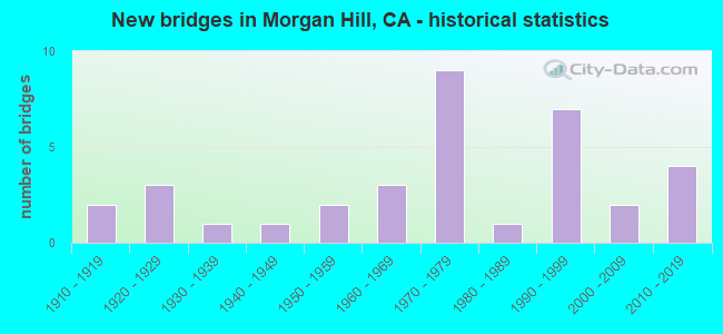
- New bridges - historical statistics
- 21910-1919
- 31920-1929
- 11930-1939
- 11940-1949
- 21950-1959
- 31960-1969
- 91970-1979
- 11980-1989
- 71990-1999
- 22000-2009
- 42010-2019
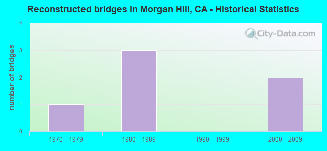
- Reconstructed bridges - Historical Statistics
- 11970-1979
- 31980-1989
- 01990-1999
- 22000-2009
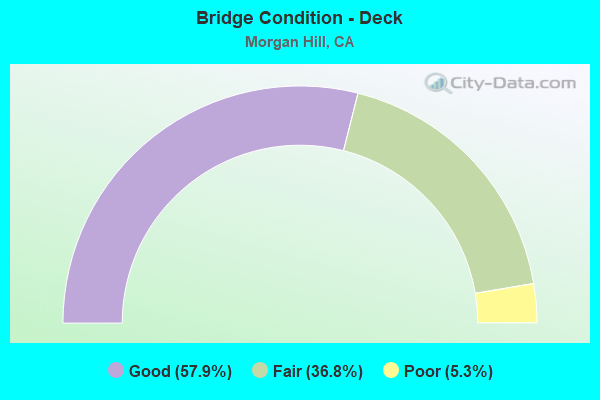
- Bridge Condition - Deck
- 57.9%Good
- 36.8%Fair
- 5.3%Poor
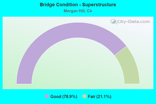
- Bridge Condition - Superstructure
- 78.9%Good
- 21.1%Fair
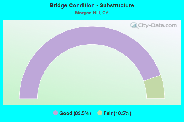
- Bridge Condition - Substructure
- 89.5%Good
- 10.5%Fair
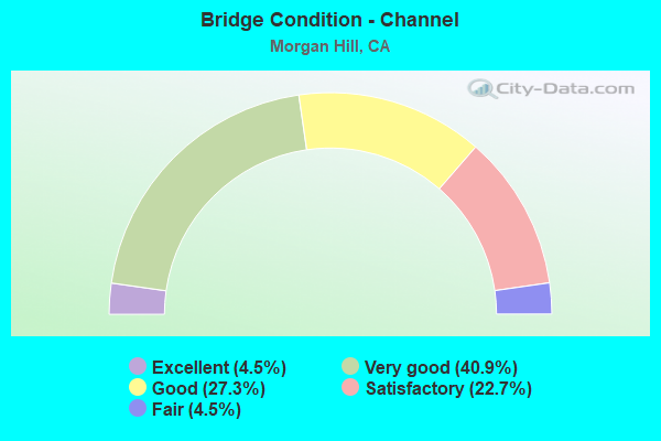
- Bridge Condition - Channel
- 4.5%Excellent
- 40.9%Very good
- 27.3%Good
- 22.7%Satisfactory
- 4.5%Fair
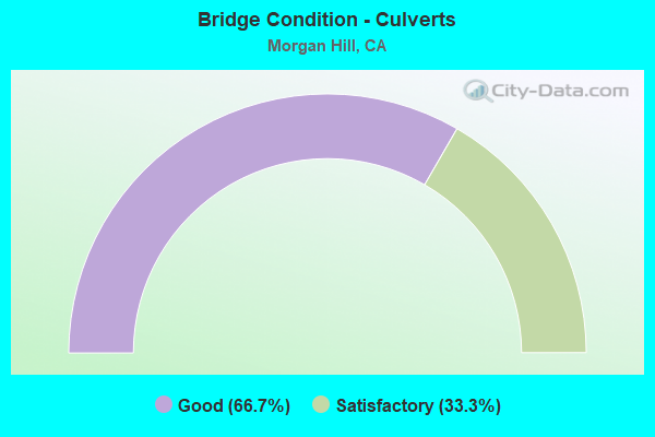
- Bridge Condition - Culverts
- 66.7%Good
- 33.3%Satisfactory
Find on map >> Show street view
Structure Number: 37 0333L, Location: 04-SCL-101-R15.07 (Lat: 37.119133, Lng: -121.626681), Route carried "on" structure: County highway C068, Year Built: 1972, Status: Open, Structure Length: 7.50m (24.61ft), Average Daily Traffic: 4,000 (year 2012), Truck Traffic: 1%, Average Future Daily Traffic: 13,360 (year 2042), Design Load: HS 20+Mod, Features Intersected: U.S. HIGHWAY 101, Facility Carried by Structure: TENNANT AVENUE WB
Minimum Vertical Clearance: 30+ m (98+ ft), Kilometerpoint: 0.000, Lanes on structure: 2, Lanes under structure: 6, Owner: State Highway Agency, Approaching Roadway Width: 12.2m (40.0ft), Material/Design: Prestressed concrete continuous, Design/Construction: Box Beam or Girders - Multiple, Number Of Spans In Main Unit: 2, Length of Maximum Span: 37.2m (122.0ft), Curb or Sidewalk Widths: Left: 1.5m (4.9ft), Right: 0.0m, Curb-To-Curb Width: 12.2m (40.0ft), Out-to-Out Width: 14.3m (46.9ft)
Condition: Deck: Good, Superstructure: Good, Substructure: Good, Operating Rating: 48.6 metric tons, Method Used To Determine Operating Rating: Load and Resistance Factor Rating (LRFR) rating reported by rating factor(RF) method using HL-93 loadings, Inventory Rating: 30.5 metric tons, Method Used To Determine Inventory Rating: Load and Resistance Factor Rating (LRFR) rating reported by rating factor(RF) method using HL-93 loadings, Structural Evaluation: Better than present minimum criteria, Deck Geometry: Better than present minimum criteria, Underclear: Equal to present minimum criteria, Approach Roadway Alignment: Equal to present desirable criteria, Designated Inspection Frequency: Every 24 months, Inspection Date: September 2020, Deck Structure Type: Concrete Cast-file-Place, Wearing Surface/Protective System: Wearing Surface: Bituminous
Find on map >> Show street view
Structure Number: 37 0333R, Location: 04-SCL-101-R15.05 (Lat: 37.119003, Lng: -121.626619), Route carried "on" structure: County highway , Year Built: 2012, Status: Open, Structure Length: 8.20m (26.90ft), Average Daily Traffic: 4,000 (year 2012), Truck Traffic: 1%, Average Future Daily Traffic: 6,121 (year 2038), Design Load: HL 93, Features Intersected: U.S. HIGHWAY 101, Facility Carried by Structure: TENNANT AVENUE EB
Minimum Vertical Clearance: 30+ m (98+ ft), Kilometerpoint: 0.000, Lanes on structure: 2, Lanes under structure: 6, Owner: State Highway Agency, Approaching Roadway Width: 11.1m (36.4ft), Material/Design: Prestressed concrete continuous, Design/Construction: Box Beam or Girders - Multiple, Number Of Spans In Main Unit: 2, Length of Maximum Span: 44.0m (144.4ft), Curb or Sidewalk Widths: Left: 0.0m, Right: 1.8m (5.9ft), Curb-To-Curb Width: 11.0m (36.1ft), Out-to-Out Width: 13.7m (44.9ft)
Condition: Deck: Good, Superstructure: Good, Substructure: Good, Operating Rating: 42.1 metric tons, Method Used To Determine Operating Rating: Assigned ratings based on Load and Resistance Factor Design (LRFD) reported by rating factor (RF) using HL93 loadings, Inventory Rating: 32.4 metric tons, Method Used To Determine Inventory Rating: Assigned ratings based on Load and Resistance Factor Design (LRFD) reported by rating factor (RF) using HL93 loadings, Structural Evaluation: Better than present minimum criteria, Deck Geometry: Equal to present minimum criteria, Underclear: Better than present minimum criteria, Approach Roadway Alignment: Equal to present desirable criteria, Designated Inspection Frequency: Every 24 months, Inspection Date: September 2020, Deck Structure Type: Concrete Cast-file-Place
Find on map >> Show street view
Structure Number: 37 0334, Location: 04-SCL-101-R16.01-MGH (Lat: 37.131433, Lng: -121.633881), Route carried "on" structure: City street , Year Built: 1972, Status: Open, Structure Length: 7.53m (24.70ft), Average Daily Traffic: 12,900 (year 1998), Truck Traffic: 1%, Average Future Daily Traffic: 21,377 (year 2040), Design Load: HS 20+Mod, Features Intersected: U.S. HIGHWAY 101, Facility Carried by Structure: WB EAST DUNNE AVE
Minimum Vertical Clearance: 30+ m (98+ ft), Kilometerpoint: 0.000, Lanes on structure: 2, Lanes under structure: 7, Owner: State Highway Agency, Approaching Roadway Width: 13.1m (43.0ft), Material/Design: Prestressed concrete continuous, Design/Construction: Box Beam or Girders - Multiple, Number Of Spans In Main Unit: 2, Length of Maximum Span: 37.4m (122.7ft), Curb or Sidewalk Widths: Left: 1.5m (4.9ft), Right: 0.0m, Curb-To-Curb Width: 12.2m (40.0ft), Out-to-Out Width: 14.3m (46.9ft)
Condition: Deck: Fair, Superstructure: Fair, Substructure: Good, Operating Rating: 51.2 metric tons, Method Used To Determine Operating Rating: Load and Resistance Factor Rating (LRFR) rating reported by rating factor(RF) method using HL-93 loadings, Inventory Rating: 32.4 metric tons, Method Used To Determine Inventory Rating: Load and Resistance Factor Rating (LRFR) rating reported by rating factor(RF) method using HL-93 loadings, Structural Evaluation: Somewhat better than minimum adequacy, Deck Geometry: Better than present minimum criteria, Underclear: Better than present minimum criteria, Approach Roadway Alignment: Equal to present desirable criteria, Designated Inspection Frequency: Every 24 months, Inspection Date: September 2020, Deck Structure Type: Concrete Cast-file-Place
Find on map >> Show street view
Structure Number: 37 0335, Location: 04-SCL-101-R16.78-MGH (Lat: 37.140822, Lng: -121.641222), Route carried "on" structure: City street , Year Built: 1972, Status: Open, Structure Length: 7.08m (23.23ft), Average Daily Traffic: 6,330 (year 1998), Truck Traffic: 1%, Average Future Daily Traffic: 12,827 (year 2040), Design Load: HS 20+Mod, Features Intersected: U.S. HIGHWAY 101, Facility Carried by Structure: EAST MAIN AVENUE
Minimum Vertical Clearance: 30+ m (98+ ft), Kilometerpoint: 0.000, Lanes on structure: 2, Lanes under structure: 6, Owner: State Highway Agency, Approaching Roadway Width: 12.2m (40.0ft), Material/Design: Prestressed concrete continuous, Design/Construction: Box Beam or Girders - Multiple, Number Of Spans In Main Unit: 2, Length of Maximum Span: 35.7m (117.1ft), Curb or Sidewalk Widths: Left: 1.5m (4.9ft), Right: 0.0m, Curb-To-Curb Width: 12.2m (40.0ft), Out-to-Out Width: 14.3m (46.9ft)
Condition: Deck: Fair, Superstructure: Good, Substructure: Good, Operating Rating: 55.4 metric tons, Method Used To Determine Operating Rating: Load and Resistance Factor Rating (LRFR) rating reported by rating factor(RF) method using HL-93 loadings, Inventory Rating: 35.0 metric tons, Method Used To Determine Inventory Rating: Load and Resistance Factor Rating (LRFR) rating reported by rating factor(RF) method using HL-93 loadings, Structural Evaluation: Better than present minimum criteria, Deck Geometry: Somewhat better than minimum adequacy, Underclear: Somewhat better than minimum adequacy, Approach Roadway Alignment: Equal to present desirable criteria, Designated Inspection Frequency: Every 24 months, Inspection Date: September 2020, Deck Structure Type: Concrete Cast-file-Place
Find on map >> Show street view
Structure Number: 37C0092, Location: BOWDEN AVE (Lat: 37.084967, Lng: -121.653600), Route carried "on" structure: County highway , Year Built: 1968, Status: Open, Structure Length: 3.77m (12.37ft), Average Daily Traffic: 4,430 (year 2014), Truck Traffic: 7%, Average Future Daily Traffic: 7,141 (year 2037), Design Load: HS 20, Features Intersected: LLAGAS CREEK, Facility Carried by Structure: WATSONVILLE RD
Minimum Vertical Clearance: 30+ m (98+ ft), Kilometerpoint: 0.000, Lanes on structure: 2, Owner: County Highway Agency, Approaching Roadway Width: 11.0m (36.1ft), Material/Design: Concrete continuous, Design/Construction: Tee Beam, Number Of Spans In Main Unit: 3, Length of Maximum Span: 14.9m (48.9ft), Curb or Sidewalk Widths: Left: 0.0m, Right: 1.5m (4.9ft), Curb-To-Curb Width: 11.0m (36.1ft), Out-to-Out Width: 14.1m (46.3ft)
Condition: Deck: Good, Superstructure: Good, Substructure: Good, Channel: Satisfactory, Operating Rating: 52.5 metric tons, Method Used To Determine Operating Rating: Load and Resistance Factor Rating (LRFR) rating reported by rating factor(RF) method using HL-93 loadings, Inventory Rating: 40.5 metric tons, Method Used To Determine Inventory Rating: Load and Resistance Factor Rating (LRFR) rating reported by rating factor(RF) method using HL-93 loadings, Structural Evaluation: Better than present minimum criteria, Deck Geometry: Somewhat better than minimum adequacy, Waterway Adequacy: Better than present minimum criteria, Approach Roadway Alignment: Equal to present desirable criteria, Designated Inspection Frequency: Every 48 months, Inspection Date: September 2020, Deck Structure Type: Concrete Cast-file-Place, Wearing Surface/Protective System: Wearing Surface: Integral Concrete
Find on map >> Show street view
Structure Number: 37C0094, Location: 0.6 MI S/O CROY RD (Lat: 37.102344, Lng: -121.724539), Route carried "on" structure: County highway , Year Built: 1928, Status: Open, Structure Length: 1.60m (5.25ft), Average Daily Traffic: 1,040 (year 2014), Truck Traffic: 5%, Average Future Daily Traffic: 3,643 (year 2041), Design Load: H 20, Features Intersected: UVAS CREEK, Facility Carried by Structure: UVAS RD
Minimum Vertical Clearance: 30+ m (98+ ft), Kilometerpoint: 0.000, Lanes on structure: 2, Owner: County Highway Agency, Approaching Roadway Width: 7.3m (24.0ft), Skew: 3 degrees, Material/Design: Concrete, Design/Construction: Girder and Floorbeam System, Number Of Spans In Main Unit: 1, Length of Maximum Span: 15.2m (49.9ft), Curb-To-Curb Width: 6.1m (20.0ft), Out-to-Out Width: 7.3m (24.0ft)
Condition: Deck: Fair, Superstructure: Good, Substructure: Good, Channel: Satisfactory, Operating Rating: 32.4 metric tons, Method Used To Determine Operating Rating: Load Factor (LF), Inventory Rating: 24.3 metric tons, Method Used To Determine Inventory Rating: Load Factor (LF), Structural Evaluation: Equal to present minimum criteria, Deck Geometry: High priority of replacement, Waterway Adequacy: Equal to present minimum criteria, Approach Roadway Alignment: High priority of corrective action, Designated Inspection Frequency: Every 24 months, Inspection Date: April 2021, Deck Structure Type: Concrete Cast-file-Place, Wearing Surface/Protective System: Wearing Surface: Bituminous
Find on map >> Show street view
Structure Number: 37C0161, Location: 0.5 MI SE WATSONVILLE RD (Lat: 37.090800, Lng: -121.638972), Route carried "on" structure: County highway , Year Built: 1969, Status: Open, Structure Length: 4.85m (15.91ft), Average Daily Traffic: 5,110 (year 2014), Truck Traffic: 5%, Average Future Daily Traffic: 7,285 (year 2041), Design Load: HS 20, Features Intersected: LLAGAS CREEK, Facility Carried by Structure: SANTA TERESA BLVD
Minimum Vertical Clearance: 30+ m (98+ ft), Kilometerpoint: 0.000, Lanes on structure: 2, Owner: County Highway Agency, Approaching Roadway Width: 13.1m (43.0ft), Skew: 3 degrees, Material/Design: Concrete continuous, Design/Construction: Tee Beam, Number Of Spans In Main Unit: 3, Length of Maximum Span: 18.9m (62.0ft), Curb-To-Curb Width: 12.5m (41.0ft), Out-to-Out Width: 13.1m (43.0ft)
Condition: Deck: Fair, Superstructure: Good, Substructure: Good, Channel: Excellent, Operating Rating: 30.1 metric tons, Method Used To Determine Operating Rating: Load and Resistance Factor Rating (LRFR) rating reported by rating factor(RF) method using HL-93 loadings, Inventory Rating: 23.3 metric tons, Method Used To Determine Inventory Rating: Load and Resistance Factor Rating (LRFR) rating reported by rating factor(RF) method using HL-93 loadings, Structural Evaluation: Somewhat better than minimum adequacy, Deck Geometry: Somewhat better than minimum adequacy, Waterway Adequacy: Equal to present desirable criteria, Approach Roadway Alignment: Better than present minimum criteria, Designated Inspection Frequency: Every 24 months, Inspection Date: April 2021, Deck Structure Type: Concrete Cast-file-Place
Find on map >> Show street view
Structure Number: 37C0163, Location: 0.4 MI W/O BOWDEN AVE (Lat: 37.089478, Lng: -121.661344), Route carried "on" structure: County highway , Year Built: 1928, Status: Open, Structure Length: 1.61m (5.28ft), Average Daily Traffic: 780 (year 2014), Truck Traffic: 5%, Average Future Daily Traffic: 1,020 (year 2037), Features Intersected: LLAGAS CREEK, Facility Carried by Structure: SYCAMORE AVE
Minimum Vertical Clearance: 30+ m (98+ ft), Kilometerpoint: 0.000, Lanes on structure: 2, Owner: County Highway Agency, Approaching Roadway Width: 7.3m (24.0ft), Skew: 2 degrees, Material/Design: Concrete, Design/Construction: Stringer/Multi-beam, Number Of Spans In Main Unit: 1, Length of Maximum Span: 14.9m (48.9ft), Curb-To-Curb Width: 6.1m (20.0ft), Out-to-Out Width: 7.3m (24.0ft)
Condition: Deck: Good, Superstructure: Good, Substructure: Good, Channel: Fair, Operating Rating: 26.6 metric tons, Method Used To Determine Operating Rating: Load Factor (LF), Inventory Rating: 16.2 metric tons, Method Used To Determine Inventory Rating: Load Factor (LF), Structural Evaluation: Meets minimum limits, Deck Geometry: High priority of corrective action, Waterway Adequacy: Equal to present minimum criteria, Approach Roadway Alignment: Equal to present minimum criteria, Designated Inspection Frequency: Every 24 months, Inspection Date: September 2020, Deck Structure Type: Concrete Cast-file-Place, Wearing Surface/Protective System: Wearing Surface: Bituminous
Find on map >> Show street view
Structure Number: 37C0164, Location: 3.19 MI SE UVAS RD (Lat: 37.114631, Lng: -121.688369), Route carried "on" structure: County highway , Year Built: 1940, Status: Open, Structure Length: 2.21m (7.25ft), Average Daily Traffic: 1,710 (year 2014), Truck Traffic: 5%, Average Future Daily Traffic: 3,558 (year 2038), Design Load: H 20, Features Intersected: LLAGAS CREEK, Facility Carried by Structure: OAK GLEN AVE
Minimum Vertical Clearance: 30+ m (98+ ft), Kilometerpoint: 0.000, Lanes on structure: 2, Owner: County Highway Agency, Approaching Roadway Width: 7.0m (23.0ft), Material/Design: Concrete continuous, Design/Construction: Tee Beam, Number Of Spans In Main Unit: 2, Length of Maximum Span: 11.0m (36.1ft), Curb-To-Curb Width: 7.3m (24.0ft), Out-to-Out Width: 7.5m (24.6ft)
Condition: Deck: Good, Superstructure: Good, Substructure: Good, Channel: Satisfactory, Operating Rating: 45.4 metric tons, Method Used To Determine Operating Rating: Load and Resistance Factor Rating (LRFR) rating reported by rating factor(RF) method using HL-93 loadings, Inventory Rating: 35.0 metric tons, Method Used To Determine Inventory Rating: Load and Resistance Factor Rating (LRFR) rating reported by rating factor(RF) method using HL-93 loadings, Structural Evaluation: Better than present minimum criteria, Deck Geometry: Meets minimum limits, Waterway Adequacy: Equal to present minimum criteria, Approach Roadway Alignment: High priority of corrective action, Designated Inspection Frequency: Every 48 months, Inspection Date: April 2021, Deck Structure Type: Concrete Cast-file-Place, Wearing Surface/Protective System: Wearing Surface: Bituminous
Find on map >> Show street view
Structure Number: 37C0166, Location: 0.5 MI E OF COYOTE RES RD (Lat: 37.152872, Lng: -121.581725), Route carried "on" structure: County highway , Year Built: 1987, Status: Open, Structure Length: 11.49m (37.70ft), Average Daily Traffic: 215 (year 2010), Truck Traffic: 5%, Average Future Daily Traffic: 512 (year 2038), Design Load: HS 20, Features Intersected: ANDERSON RESERVOIR, Facility Carried by Structure: EAST DUNNE AVE
Minimum Vertical Clearance: 5.03m (16.50ft), Kilometerpoint: 0.000, Lanes on structure: 2, Owner: County Highway Agency, Approaching Roadway Width: 7.3m (24.0ft), Skew: 9 degrees, Material/Design: Steel, Design/Construction: Truss - Thru, Number Of Spans In Main Unit: 1, Number Of Approach Spans: 2, Length of Maximum Span: 91.4m (299.9ft), Curb-To-Curb Width: 9.8m (32.2ft), Out-to-Out Width: 11.2m (36.7ft)
Condition: Deck: Fair, Superstructure: Good, Substructure: Good, Channel: Very good, Operating Rating: 30.1 metric tons, Method Used To Determine Operating Rating: Load Factor (LF), Inventory Rating: 18.1 metric tons, Method Used To Determine Inventory Rating: Load Factor (LF), Structural Evaluation: Somewhat better than minimum adequacy, Deck Geometry: Better than present minimum criteria, Waterway Adequacy: Equal to present desirable criteria, Approach Roadway Alignment: Meets minimum limits, Designated Inspection Frequency: Every 24 months, Critical Feature Inspection Frequency: Every 24 months, Inspection Date: November 2020, Critical Feature Inspection Date: May 2020, Deck Structure Type: Concrete Cast-file-Place
Find on map >> Show street view
Structure Number: 37C0168, Location: SUNNYSIDE AVE (Lat: 37.106056, Lng: -121.657558), Route carried "on" structure: County highway , Year Built: 1915, Year Reconstructed: 1975, Status: Open, Structure Length: 0.73m (2.40ft), Average Daily Traffic: 2,410 (year 2014), Truck Traffic: 5%, Average Future Daily Traffic: 3,254 (year 2038), Features Intersected: LITTLE LLAGAS CRK, Facility Carried by Structure: EDMUNDSON AVE
Minimum Vertical Clearance: 30+ m (98+ ft), Kilometerpoint: 0.000, Lanes on structure: 2, Owner: County Highway Agency, Approaching Roadway Width: 7.6m (24.9ft), Skew: 4 degrees, Material/Design: Concrete continuous, Design/Construction: Culvert, Number Of Spans In Main Unit: 2, Length of Maximum Span: 6.9m (22.6ft), Curb-To-Curb Width: 9.8m (32.2ft), Out-to-Out Width: 10.0m (32.8ft)
Condition: Channel: Satisfactory, Culverts: Good, Operating Rating: 27.2 metric tons, Method Used To Determine Operating Rating: Field evaluation and documented engineering judgment, Inventory Rating: 16.2 metric tons, Method Used To Determine Inventory Rating: Field evaluation and documented engineering judgment, Structural Evaluation: Meets minimum limits, Deck Geometry: Meets minimum limits, Waterway Adequacy: Somewhat better than minimum adequacy, Approach Roadway Alignment: Equal to present minimum criteria, Designated Inspection Frequency: Every 24 months, Inspection Date: April 2021, Deck Structure Type: Concrete Cast-file-Place, Wearing Surface/Protective System: Wearing Surface: Bituminous
Find on map >> Show street view
Structure Number: 37C032, Location: NEAR FORREST ST (Lat: 37.010822, Lng: -121.565589), Route carried "on" structure: City street , Year Built: 1999, Status: Open, Structure Length: 1.91m (6.27ft), Average Daily Traffic: 2,231 (year 2012), Truck Traffic: 3%, Average Future Daily Traffic: 2,500 (year 2037), Design Load: HS 20+Mod, Features Intersected: MILLER SLOUGH, Facility Carried by Structure: LEWIS ST
Minimum Vertical Clearance: 30+ m (98+ ft), Kilometerpoint: 0.000, Lanes on structure: 2, Owner: City or Municipal Highway Agency, Approaching Roadway Width: 11.6m (38.1ft), Skew: 3 degrees, Material/Design: Concrete continuous, Design/Construction: Slab, Number Of Spans In Main Unit: 2, Length of Maximum Span: 9.1m (29.9ft), Curb or Sidewalk Widths: Left: 1.5m (4.9ft), Right: 1.5m (4.9ft), Curb-To-Curb Width: 11.6m (38.1ft), Out-to-Out Width: 15.2m (49.9ft)
Condition: Deck: Fair, Superstructure: Fair, Substructure: Good, Channel: Very good, Operating Rating: 38.6 metric tons, Method Used To Determine Operating Rating: Load and Resistance Factor Rating (LRFR) rating reported by rating factor(RF) method using HL-93 loadings, Inventory Rating: 26.6 metric tons, Method Used To Determine Inventory Rating: Load and Resistance Factor Rating (LRFR) rating reported by rating factor(RF) method using HL-93 loadings, Structural Evaluation: Somewhat better than minimum adequacy, Deck Geometry: Somewhat better than minimum adequacy, Waterway Adequacy: Better than present minimum criteria, Approach Roadway Alignment: Equal to present desirable criteria, Designated Inspection Frequency: Every 24 months, Inspection Date: December 2020, Deck Structure Type: Concrete Cast-file-Place
Find on map >> Show street view
Structure Number: 37C0328, Location: N/O VINEYARD BLVD (Lat: 37.109861, Lng: -121.644519), Route carried "on" structure: City street , Year Built: 1979, Year Reconstructed: 1991, Status: Open, Structure Length: 1.61m (5.28ft), Average Daily Traffic: 350 (year 2010), Truck Traffic: 2%, Average Future Daily Traffic: 641 (year 2044), Features Intersected: LITTLE LLAGAS CREEK, Facility Carried by Structure: LA CROSSE DR
Minimum Vertical Clearance: 30+ m (98+ ft), Kilometerpoint: 0.000, Lanes on structure: 2, Owner: City or Municipal Highway Agency, Approaching Roadway Width: 15.2m (49.9ft), Skew: 4 degrees, Material/Design: Concrete continuous, Design/Construction: Culvert, Number Of Spans In Main Unit: 3, Length of Maximum Span: 5.2m (17.1ft), Curb or Sidewalk Widths: Left: 2.4m (7.9ft), Right: 2.4m (7.9ft), Curb-To-Curb Width: 15.2m (49.9ft), Out-to-Out Width: 20.7m (67.9ft)
Condition: Channel: Good, Culverts: Good, Operating Rating: 54.1 metric tons, Method Used To Determine Operating Rating: Field evaluation and documented engineering judgment, Inventory Rating: 32.4 metric tons, Method Used To Determine Inventory Rating: Field evaluation and documented engineering judgment, Structural Evaluation: Better than present minimum criteria, Deck Geometry: Superior to present desirable criteria, Waterway Adequacy: Better than present minimum criteria, Approach Roadway Alignment: Equal to present desirable criteria, Designated Inspection Frequency: Every 48 months, Inspection Date: January 2022, Deck Structure Type: Concrete Cast-file-Place, Wearing Surface/Protective System: Wearing Surface: Bituminous
Find on map >> Show street view
Structure Number: 37C0329, Location: S/O VINEYARD BLVD (Lat: 37.108197, Lng: -121.642311), Route carried "on" structure: City street , Year Built: 1979, Year Reconstructed: 1991, Status: Open, Structure Length: 1.64m (5.38ft), Average Daily Traffic: 400 (year 2010), Truck Traffic: 2%, Average Future Daily Traffic: 641 (year 2044), Features Intersected: LITTLE LLAGAS CREEK, Facility Carried by Structure: LA CROSSE DR
Minimum Vertical Clearance: 30+ m (98+ ft), Kilometerpoint: 0.000, Lanes on structure: 2, Owner: City or Municipal Highway Agency, Approaching Roadway Width: 15.2m (49.9ft), Skew: 1 degrees, Material/Design: Concrete continuous, Design/Construction: Culvert, Number Of Spans In Main Unit: 4, Length of Maximum Span: 4.0m (13.1ft), Curb or Sidewalk Widths: Left: 2.4m (7.9ft), Right: 2.4m (7.9ft), Curb-To-Curb Width: 15.2m (49.9ft), Out-to-Out Width: 20.7m (67.9ft)
Condition: Channel: Good, Culverts: Good, Operating Rating: 54.1 metric tons, Method Used To Determine Operating Rating: Field evaluation and documented engineering judgment, Inventory Rating: 32.4 metric tons, Method Used To Determine Inventory Rating: Field evaluation and documented engineering judgment, Structural Evaluation: Better than present minimum criteria, Deck Geometry: Superior to present desirable criteria, Waterway Adequacy: Better than present minimum criteria, Approach Roadway Alignment: Equal to present desirable criteria, Designated Inspection Frequency: Every 48 months, Inspection Date: January 2022, Deck Structure Type: Concrete Cast-file-Place, Wearing Surface/Protective System: Wearing Surface: Bituminous
Find on map >> Show street view
Structure Number: 37C0368, Location: 0.25 MI W MONTEREY HWY (Lat: 37.099686, Lng: -121.630267), Route carried "on" structure: County highway , Year Built: 1990, Status: Open, Structure Length: 3.06m (10.04ft), Average Daily Traffic: 2,170 (year 2014), Truck Traffic: 5%, Average Future Daily Traffic: 2,897 (year 2042), Design Load: HS 20+Mod, Features Intersected: W LITTLE LLAGAS CREEK, Facility Carried by Structure: W MIDDLE AVE
Minimum Vertical Clearance: 30+ m (98+ ft), Kilometerpoint: 0.000, Lanes on structure: 2, Owner: County Highway Agency, Approaching Roadway Width: 9.1m (29.9ft), Material/Design: Concrete continuous, Design/Construction: Slab, Number Of Spans In Main Unit: 3, Length of Maximum Span: 11.3m (37.1ft), Curb-To-Curb Width: 10.4m (34.1ft), Out-to-Out Width: 11.4m (37.4ft)
Condition: Deck: Good, Superstructure: Good, Substructure: Good, Channel: Very good, Operating Rating: 54.1 metric tons, Method Used To Determine Operating Rating: Assigned rating based on Load Factor Design (LFD) reported in metric tons, Inventory Rating: 32.4 metric tons, Method Used To Determine Inventory Rating: Assigned rating based on Load Factor Design (LFD) reported in metric tons, Structural Evaluation: Better than present minimum criteria, Deck Geometry: Somewhat better than minimum adequacy, Waterway Adequacy: Equal to present desirable criteria, Approach Roadway Alignment: Equal to present desirable criteria, Designated Inspection Frequency: Every 48 months, Inspection Date: November 2020, Deck Structure Type: Concrete Cast-file-Place
Find on map >> Show street view
Structure Number: 37C0377, Location: 0.2 MI W MONTEREY HWY (Lat: 37.104575, Lng: -121.638122), Route carried "on" structure: County highway , Year Built: 1991, Status: Open, Structure Length: 3.29m (10.79ft), Average Daily Traffic: 4,430 (year 2014), Truck Traffic: 5%, Average Future Daily Traffic: 10,202 (year 2036), Design Load: HS 20, Features Intersected: W LITTLE LLAGAS CRK, Facility Carried by Structure: WATSONVILLE ROAD
Minimum Vertical Clearance: 30+ m (98+ ft), Kilometerpoint: 0.000, Lanes on structure: 2, Owner: County Highway Agency, Approaching Roadway Width: 16.8m (55.1ft), Material/Design: Concrete continuous, Design/Construction: Slab, Number Of Spans In Main Unit: 3, Length of Maximum Span: 12.1m (39.7ft), Curb or Sidewalk Widths: Left: 1.5m (4.9ft), Right: 0.0m, Curb-To-Curb Width: 16.8m (55.1ft), Out-to-Out Width: 23.2m (76.1ft)
Condition: Deck: Good, Superstructure: Good, Substructure: Good, Operating Rating: 54.1 metric tons, Method Used To Determine Operating Rating: Field evaluation and documented engineering judgment, Inventory Rating: 32.4 metric tons, Method Used To Determine Inventory Rating: Field evaluation and documented engineering judgment, Structural Evaluation: Better than present minimum criteria, Deck Geometry: Superior to present desirable criteria, Approach Roadway Alignment: Equal to present desirable criteria, Designated Inspection Frequency: Every 48 months, Inspection Date: September 2018, Deck Structure Type: Concrete Cast-file-Place
Find on map >> Show street view
Structure Number: 37C0404, Location: 100 M E/O S BLANEY AVE (Lat: 37.300867, Lng: -122.026775), Route carried "on" structure: City street , Year Built: 1992, Status: Open, Structure Length: 0.93m (3.05ft), Average Daily Traffic: 6,000 (year 2004), Truck Traffic: 5%, Average Future Daily Traffic: 9,429 (year 2038), Features Intersected: CALABAZAS CREEK, Facility Carried by Structure: RAINBOW DRIVE
Minimum Vertical Clearance: 30+ m (98+ ft), Kilometerpoint: 0.000, Lanes on structure: 3, Owner: City or Municipal Highway Agency, Approaching Roadway Width: 19.5m (64.0ft), Skew: 3 degrees, Material/Design: Concrete continuous, Design/Construction: Culvert, Number Of Spans In Main Unit: 2, Length of Maximum Span: 3.5m (11.5ft), Curb or Sidewalk Widths: Left: 2.0m (6.6ft), Right: 2.0m (6.6ft), Curb-To-Curb Width: 19.5m (64.0ft), Out-to-Out Width: 24.0m (78.7ft)
Condition: Channel: Good, Culverts: Satisfactory, Operating Rating: 54.1 metric tons, Method Used To Determine Operating Rating: Field evaluation and documented engineering judgment, Inventory Rating: 32.4 metric tons, Method Used To Determine Inventory Rating: Field evaluation and documented engineering judgment, Structural Evaluation: Equal to present minimum criteria, Deck Geometry: Superior to present desirable criteria, Waterway Adequacy: Better than present minimum criteria, Approach Roadway Alignment: Better than present minimum criteria, Designated Inspection Frequency: Every 48 months, Inspection Date: March 2020, Deck Structure Type: Concrete Cast-file-Place, Wearing Surface/Protective System: Wearing Surface: Bituminous
Find on map >> Show street view
Structure Number: 37C0408, Location: 200 M W/O MONTEREY RD (Lat: 37.118017, Lng: -121.647428), Route carried "on" structure: City street , Year Built: 1991, Status: Open, Structure Length: 0.98m (3.22ft), Average Daily Traffic: 1,100 (year 2010), Truck Traffic: 5%, Average Future Daily Traffic: 1,283 (year 2044), Features Intersected: W LITTLE LLAGAS CREEK, Facility Carried by Structure: COSMO LANE
Minimum Vertical Clearance: 30+ m (98+ ft), Kilometerpoint: 0.000, Lanes on structure: 2, Owner: City or Municipal Highway Agency, Approaching Roadway Width: 18.0m (59.1ft), Material/Design: Concrete continuous, Design/Construction: Culvert, Number Of Spans In Main Unit: 3, Length of Maximum Span: 3.0m (9.8ft), Curb or Sidewalk Widths: Left: 2.7m (8.9ft), Right: 2.7m (8.9ft), Curb-To-Curb Width: 12.0m (39.4ft), Out-to-Out Width: 18.1m (59.4ft)
Condition: Channel: Good, Culverts: Good, Operating Rating: 54.1 metric tons, Method Used To Determine Operating Rating: Field evaluation and documented engineering judgment, Inventory Rating: 32.4 metric tons, Method Used To Determine Inventory Rating: Field evaluation and documented engineering judgment, Structural Evaluation: Better than present minimum criteria, Deck Geometry: Equal to present minimum criteria, Waterway Adequacy: Better than present minimum criteria, Approach Roadway Alignment: Better than present minimum criteria, Designated Inspection Frequency: Every 48 months, Inspection Date: January 2022, Deck Structure Type: Concrete Cast-file-Place
Find on map >> Show street view
Structure Number: 37C0409, Location: 200 M W/O MONTEREY RD (Lat: 37.115031, Lng: -121.645814), Route carried "on" structure: City street , Year Built: 1991, Status: Open, Structure Length: 0.98m (3.22ft), Average Daily Traffic: 900 (year 2010), Truck Traffic: 5%, Average Future Daily Traffic: 1,016 (year 2044), Features Intersected: W LITTLE LLAGAS CREEK, Facility Carried by Structure: EDES CT
Minimum Vertical Clearance: 30+ m (98+ ft), Kilometerpoint: 0.000, Lanes on structure: 2, Owner: City or Municipal Highway Agency, Approaching Roadway Width: 18.0m (59.1ft), Material/Design: Concrete continuous, Design/Construction: Culvert, Number Of Spans In Main Unit: 3, Length of Maximum Span: 3.0m (9.8ft), Curb or Sidewalk Widths: Left: 2.7m (8.9ft), Right: 2.7m (8.9ft), Curb-To-Curb Width: 12.0m (39.4ft), Out-to-Out Width: 18.1m (59.4ft)
Condition: Channel: Good, Culverts: Good, Operating Rating: 54.1 metric tons, Method Used To Determine Operating Rating: Field evaluation and documented engineering judgment, Inventory Rating: 32.4 metric tons, Method Used To Determine Inventory Rating: Field evaluation and documented engineering judgment, Structural Evaluation: Better than present minimum criteria, Deck Geometry: Better than present minimum criteria, Waterway Adequacy: Better than present minimum criteria, Approach Roadway Alignment: Better than present minimum criteria, Designated Inspection Frequency: Every 48 months, Inspection Date: January 2022, Deck Structure Type: Concrete Cast-file-Place, Wearing Surface/Protective System: Wearing Surface: Bituminous
Find on map >> Show street view
Structure Number: 37C043, Location: 1000' WEST OF LAWRENCE EX (Lat: 37.337625, Lng: -122.000217), Route carried "on" structure: City street , Year Built: 1958, Year Reconstructed: 1994, Status: Open, Structure Length: 1.43m (4.69ft), Average Daily Traffic: 20,000 (year 2012), Truck Traffic: 2%, Average Future Daily Traffic: 30,707 (year 2041), Features Intersected: CALABAZAS CREEK, Facility Carried by Structure: HOMESTEAD ROAD
Minimum Vertical Clearance: 30+ m (98+ ft), Kilometerpoint: 0.000, Lanes on structure: 5, Base Highway Network: Yes, Owner: City or Municipal Highway Agency, Approaching Roadway Width: 23.0m (75.5ft), Skew: 20 degrees, Material/Design: Concrete continuous, Design/Construction: Culvert, Number Of Spans In Main Unit: 4, Number Of Approach Spans: 2, Length of Maximum Span: 3.4m (11.2ft), Curb or Sidewalk Widths: Left: 1.7m (5.6ft), Right: 2.8m (9.2ft), Curb-To-Curb Width: 22.0m (72.2ft), Out-to-Out Width: 29.7m (97.4ft)
Condition: Channel: Very good, Culverts: Satisfactory, Operating Rating: 40.5 metric tons, Method Used To Determine Operating Rating: Field evaluation and documented engineering judgment, Inventory Rating: 24.3 metric tons, Method Used To Determine Inventory Rating: Field evaluation and documented engineering judgment, Structural Evaluation: Equal to present minimum criteria, Deck Geometry: Somewhat better than minimum adequacy, Waterway Adequacy: Equal to present desirable criteria, Approach Roadway Alignment: Equal to present desirable criteria, Designated Inspection Frequency: Every 24 months, Inspection Date: June 2021, Deck Structure Type: Concrete Cast-file-Place, Wearing Surface/Protective System: Wearing Surface: Bituminous
Find on map >> Show street view
Structure Number: 37C0432, Location: SOUTH OF TENNANT AVE (Lat: 37.110417, Lng: -121.631294), Route carried "on" structure: City street , Year Built: 2013, Status: Open, Structure Length: 6.77m (22.21ft), Average Daily Traffic: 10,002 (year 2014), Truck Traffic: 5%, Average Future Daily Traffic: 13,009 (year 2044), Design Load: HL 93, Features Intersected: RAILROAD AVENUE, Facility Carried by Structure: BUTTERFIELD BLVD
Minimum Vertical Clearance: 30+ m (98+ ft), Kilometerpoint: 0.000, Lanes on structure: 4, Lanes under structure: 2, Owner: City or Municipal Highway Agency, Approaching Roadway Width: 20.0m (65.6ft), Skew: 21 degrees, Material/Design: Prestressed concrete continuous, Design/Construction: Stringer/Multi-beam, Number Of Spans In Main Unit: 2, Length of Maximum Span: 39.2m (128.6ft), Curb or Sidewalk Widths: Left: 1.5m (4.9ft), Right: 1.5m (4.9ft), Curb-To-Curb Width: 22.6m (74.1ft), Out-to-Out Width: 26.2m (86.0ft)
Condition: Deck: Poor, Superstructure: Good, Substructure: Good, Operating Rating: 42.1 metric tons, Method Used To Determine Operating Rating: Assigned ratings based on Load and Resistance Factor Design (LRFD) reported by rating factor (RF) using HL93 loadings, Inventory Rating: 32.4 metric tons, Method Used To Determine Inventory Rating: Assigned ratings based on Load and Resistance Factor Design (LRFD) reported by rating factor (RF) using HL93 loadings, Structural Evaluation: Better than present minimum criteria, Deck Geometry: Superior to present desirable criteria, Underclear: Superior to present desirable criteria, Approach Roadway Alignment: Equal to present desirable criteria, Designated Inspection Frequency: Every 24 months, Inspection Date: January 2022, Deck Structure Type: Concrete Cast-file-Place
Find on map >> Show street view
Structure Number: 37C0438, Location: JEO WATSONVILLE ROAD (Lat: 37.107497, Lng: -121.635039), Route carried "on" structure: City street , Year Built: 1965, Year Reconstructed: 2013, Status: Open, Structure Length: 0.65m (2.13ft), Average Daily Traffic: 22,000 (year 2012), Truck Traffic: 5%, Average Future Daily Traffic: 28,660 (year 2040), Features Intersected: W. LITTLE LLAGAS CREEK, Facility Carried by Structure: MONTEREY ROAD
Minimum Vertical Clearance: 30+ m (98+ ft), Kilometerpoint: 0.000, Lanes on structure: 6, Owner: City or Municipal Highway Agency, Approaching Roadway Width: 20.0m (65.6ft), Skew: 9 degrees, Material/Design: Concrete continuous, Design/Construction: Culvert, Number Of Spans In Main Unit: 2, Length of Maximum Span: 3.0m (9.8ft), Curb-To-Curb Width: 43.3m (142.1ft), Out-to-Out Width: 45.2m (148.3ft)
Condition: Channel: Very good, Culverts: Good, Operating Rating: 54.1 metric tons, Method Used To Determine Operating Rating: Field evaluation and documented engineering judgment, Inventory Rating: 32.4 metric tons, Method Used To Determine Inventory Rating: Field evaluation and documented engineering judgment, Structural Evaluation: Better than present minimum criteria, Deck Geometry: Superior to present desirable criteria, Waterway Adequacy: Equal to present desirable criteria, Approach Roadway Alignment: Equal to present desirable criteria, Designated Inspection Frequency: Every 24 months, Inspection Date: January 2022, Deck Structure Type: Concrete Cast-file-Place, Wearing Surface/Protective System: Wearing Surface: Bituminous
Find on map >> Show street view
Structure Number: 37C0439, Location: JWO MONTEREY ROAD (Lat: 37.107342, Lng: -121.635797), Route carried "on" structure: City street , Year Built: 2013, Status: Open, Structure Length: 0.67m (2.20ft), Average Daily Traffic: 4,200 (year 2012), Truck Traffic: 2%, Average Future Daily Traffic: 5,323 (year 2040), Design Load: HS 20, Features Intersected: W. LITTLE LLAGAS CREEK, Facility Carried by Structure: WATSONVILLE ROAD
Minimum Vertical Clearance: 30+ m (98+ ft), Kilometerpoint: 0.000, Lanes on structure: 4, Owner: City or Municipal Highway Agency, Approaching Roadway Width: 20.2m (66.3ft), Skew: 4 degrees, Material/Design: Concrete continuous, Design/Construction: Culvert, Number Of Spans In Main Unit: 2, Length of Maximum Span: 3.0m (9.8ft), Curb-To-Curb Width: 36.0m (118.1ft), Out-to-Out Width: 36.6m (120.1ft)
Condition: Channel: Very good, Culverts: Satisfactory, Operating Rating: 54.1 metric tons, Method Used To Determine Operating Rating: Field evaluation and documented engineering judgment, Inventory Rating: 32.4 metric tons, Method Used To Determine Inventory Rating: Field evaluation and documented engineering judgment, Structural Evaluation: Equal to present minimum criteria, Deck Geometry: Superior to present desirable criteria, Waterway Adequacy: Equal to present desirable criteria, Approach Roadway Alignment: Equal to present desirable criteria, Designated Inspection Frequency: Every 48 months, Inspection Date: January 2022, Deck Structure Type: Concrete Cast-file-Place, Wearing Surface/Protective System: Wearing Surface: Bituminous
Find on map >> Show street view
Structure Number: 37C0518, Location: 0.1 MI N WATSONVILLE RD (Lat: 37.084719, Lng: -121.653958), Route carried "on" structure: County highway , Year Built: 1919, Status: Open, Structure Length: 4.05m (13.29ft), Average Daily Traffic: 240 (year 2015), Truck Traffic: 5%, Average Future Daily Traffic: 305 (year 2038), Features Intersected: LLAGAS CREEK, Facility Carried by Structure: BOWDEN CT
Minimum Vertical Clearance: 30+ m (98+ ft), Kilometerpoint: 0.000, Lanes on structure: 1, Owner: County Highway Agency, Approaching Roadway Width: 6.7m (22.0ft), Skew: 3 degrees, Material/Design: Concrete continuous, Design/Construction: Girder and Floorbeam System, Number Of Spans In Main Unit: 3, Length of Maximum Span: 12.4m (40.7ft), Curb-To-Curb Width: 6.1m (20.0ft), Out-to-Out Width: 7.3m (24.0ft)
Condition: Deck: Good, Superstructure: Fair, Substructure: Fair, Channel: Satisfactory, Operating Rating: 32.4 metric tons, Method Used To Determine Operating Rating: Load Factor (LF), Inventory Rating: 19.4 metric tons, Method Used To Determine Inventory Rating: Load Factor (LF), Structural Evaluation: Somewhat better than minimum adequacy, Deck Geometry: Meets minimum limits, Waterway Adequacy: Better than present minimum criteria, Approach Roadway Alignment: Equal to present minimum criteria, Designated Inspection Frequency: Every 24 months, Inspection Date: April 2021, Deck Structure Type: Concrete Cast-file-Place, Wearing Surface/Protective System: Wearing Surface: Bituminous
Find on map >> Show street view
Structure Number: 37C057, Location: 0.3 MI S/O MT EDEN RD (Lat: 37.276306, Lng: -122.075217), Route carried "on" structure: County highway , Year Built: 1957, Status: Open, Structure Length: 1.55m (5.09ft), Average Daily Traffic: 810 (year 2014), Truck Traffic: 2%, Average Future Daily Traffic: 1,769 (year 2042), Features Intersected: STEVENS CREEK, Facility Carried by Structure: STEVENS CYN RD
Minimum Vertical Clearance: 30+ m (98+ ft), Kilometerpoint: 0.000, Lanes on structure: 2, Owner: County Highway Agency, Approaching Roadway Width: 6.4m (21.0ft), Material/Design: Steel, Design/Construction: Stringer/Multi-beam, Number Of Spans In Main Unit: 1, Length of Maximum Span: 14.9m (48.9ft), Curb or Sidewalk Widths: Left: 0.3m (1.0ft), Right: 0.3m (1.0ft), Curb-To-Curb Width: 6.7m (22.0ft), Out-to-Out Width: 7.9m (25.9ft)
Condition: Deck: Good, Superstructure: Fair, Substructure: Fair, Channel: Good, Operating Rating: 26.6 metric tons, Method Used To Determine Operating Rating: Load Factor (LF), Inventory Rating: 15.9 metric tons, Method Used To Determine Inventory Rating: Load Factor (LF), Structural Evaluation: Meets minimum limits, Deck Geometry: Meets minimum limits, Waterway Adequacy: Meets minimum limits, Approach Roadway Alignment: Somewhat better than minimum adequacy, Designated Inspection Frequency: Every 24 months, Inspection Date: Febuary 2022, Deck Structure Type: Wood or Timber, Wearing Surface/Protective System: Wearing Surface: Bituminous
Find on map >> Show street view
Structure Number: 37C0579, Location: 0.1 MI E HALE AVE (Lat: 37.151769, Lng: -121.680267), Route carried "on" structure: County highway , Year Built: 1927, Year Reconstructed: 2008, Status: Open, Structure Length: 0.70m (2.30ft), Average Daily Traffic: 2,100 (year 2010), Truck Traffic: 5%, Average Future Daily Traffic: 2,550 (year 2037), Features Intersected: FISHER CREEK, Facility Carried by Structure: TILTON AVE
Minimum Vertical Clearance: 30+ m (98+ ft), Kilometerpoint: 0.000, Lanes on structure: 2, Owner: City or Municipal Highway Agency, Approaching Roadway Width: 10.9m (35.8ft), Material/Design: Concrete, Design/Construction: Slab, Number Of Spans In Main Unit: 1, Length of Maximum Span: 6.1m (20.0ft), Curb-To-Curb Width: 10.2m (33.5ft), Out-to-Out Width: 11.1m (36.4ft)
Condition: Deck: Good, Superstructure: Good, Substructure: Good, Channel: Very good, Operating Rating: 28.2 metric tons, Method Used To Determine Operating Rating: Field evaluation and documented engineering judgment, Inventory Rating: 16.8 metric tons, Method Used To Determine Inventory Rating: Field evaluation and documented engineering judgment, Structural Evaluation: Meets minimum limits, Deck Geometry: Meets minimum limits, Waterway Adequacy: High priority of corrective action, Approach Roadway Alignment: Equal to present desirable criteria, Designated Inspection Frequency: Every 24 months, Inspection Date: September 2020, Deck Structure Type: Concrete Cast-file-Place, Wearing Surface/Protective System: Wearing Surface: Bituminous
Find on map >> Show street view
Structure Number: 37C0599, Location: 0.7MI W OF WATSONVILLE RD (Lat: 37.059881, Lng: -121.673533), Route carried "on" structure: County highway , Year Built: 2008, Status: Open, Structure Length: 6.80m (22.31ft), Average Daily Traffic: 1,040 (year 2014), Truck Traffic: 5%, Average Future Daily Traffic: 2,040 (year 2037), Design Load: HS 20, Features Intersected: UVAS CREEK, Facility Carried by Structure: UVAS ROAD
Minimum Vertical Clearance: 30+ m (98+ ft), Kilometerpoint: 0.000, Lanes on structure: 2, Owner: County Highway Agency, Approaching Roadway Width: 10.8m (35.4ft), Material/Design: Prestressed concrete continuous, Design/Construction: Stringer/Multi-beam, Number Of Spans In Main Unit: 3, Length of Maximum Span: 24.9m (81.7ft), Curb-To-Curb Width: 10.8m (35.4ft), Out-to-Out Width: 11.7m (38.4ft)
Condition: Deck: Good, Superstructure: Good, Substructure: Good, Channel: Very good, Operating Rating: 54.1 metric tons, Method Used To Determine Operating Rating: Assigned rating based on Load Factor Design (LFD) reported in metric tons, Inventory Rating: 32.4 metric tons, Method Used To Determine Inventory Rating: Assigned rating based on Load Factor Design (LFD) reported in metric tons, Structural Evaluation: Better than present minimum criteria, Deck Geometry: Equal to present minimum criteria, Waterway Adequacy: Equal to present desirable criteria, Approach Roadway Alignment: Equal to present desirable criteria, Designated Inspection Frequency: Every 48 months, Inspection Date: September 2020, Deck Structure Type: Concrete Cast-file-Place
Find on map >> Show street view
Structure Number: 37C082, Location: OAK GLEN AVE (Lat: 37.098658, Lng: -121.671925), Route carried "on" structure: County highway , Year Built: 1998, Status: Open, Structure Length: 3.87m (12.70ft), Average Daily Traffic: 2,410 (year 2014), Truck Traffic: 5%, Average Future Daily Traffic: 2,780 (year 2038), Design Load: HS 20+Mod, Features Intersected: LLAGAS CREEK, Facility Carried by Structure: EDMUNDSON AVE
Minimum Vertical Clearance: 30+ m (98+ ft), Kilometerpoint: 0.000, Lanes on structure: 2, Owner: County Highway Agency, Approaching Roadway Width: 13.3m (43.6ft), Material/Design: Prestressed concrete, Design/Construction: Box Beam or Girders - Single/Spread, Number Of Spans In Main Unit: 1, Length of Maximum Span: 37.3m (122.4ft), Curb-To-Curb Width: 12.2m (40.0ft), Out-to-Out Width: 13.3m (43.6ft)
Condition: Deck: Fair, Superstructure: Good, Substructure: Good, Channel: Very good, Operating Rating: 54.1 metric tons, Method Used To Determine Operating Rating: Assigned rating based on Load Factor Design (LFD) reported in metric tons, Inventory Rating: 32.4 metric tons, Method Used To Determine Inventory Rating: Assigned rating based on Load Factor Design (LFD) reported in metric tons, Structural Evaluation: Better than present minimum criteria, Deck Geometry: Equal to present minimum criteria, Waterway Adequacy: Superior to present desirable criteria, Approach Roadway Alignment: High priority of corrective action, Designated Inspection Frequency: Every 24 months, Inspection Date: April 2021, Deck Structure Type: Concrete Cast-file-Place
Find on map >> Show street view
Structure Number: 37 0333L, Location: 04-SCL-101-R15.07 (Lat: 37.119133, Lng: -121.626681), Route carried "under" structure: US 101, Year Built: 1972, Structure Length: 0. m, Average Daily Traffic: 112,000 (year 2009), Truck Traffic: 13%, Features Intersected: U.S. HIGHWAY 101, Facility Carried by Structure: TENNANT AVENUE WB
Minimum Vertical Clearance: 5.18m (16.99ft), Kilometerpoint: 15.070, Lanes on structure: 2, Lanes under structure: 6, Material/Design: Prestressed concrete continuous, Design/Construction: Box Beam or Girders - Multiple, Length of Maximum Span: 37.2m (122.0ft)
Find on map >> Show street view
Structure Number: 37 0333R, Location: 04-SCL-101-R15.05 (Lat: 37.119003, Lng: -121.626619), Route carried "under" structure: US 101, Year Built: 2012, Structure Length: 0. m, Average Daily Traffic: 11,200 (year 2009), Truck Traffic: 13%, Features Intersected: U.S. HIGHWAY 101, Facility Carried by Structure: TENNANT AVENUE EB
Minimum Vertical Clearance: 5.56m (18.24ft), Kilometerpoint: 15.050, Lanes on structure: 2, Lanes under structure: 6, Material/Design: Prestressed concrete continuous, Design/Construction: Box Beam or Girders - Multiple, Length of Maximum Span: 44.0m (144.4ft)
Find on map >> Show street view
Structure Number: 37 0334, Location: 04-SCL-101-R16.01-MGH (Lat: 37.131433, Lng: -121.633881), Route carried "under" structure: US 101, Year Built: 1972, Structure Length: 0. m, Average Daily Traffic: 112,000 (year 2009), Truck Traffic: 13%, Features Intersected: U.S. HIGHWAY 101, Facility Carried by Structure: WB EAST DUNNE AVE
Minimum Vertical Clearance: 5.23m (17.16ft), Kilometerpoint: 16.010, Lanes on structure: 2, Lanes under structure: 7, Material/Design: Prestressed concrete continuous, Design/Construction: Box Beam or Girders - Multiple, Length of Maximum Span: 37.4m (122.7ft)
Find on map >> Show street view
Structure Number: 37 0335, Location: 04-SCL-101-R16.78-MGH (Lat: 37.140822, Lng: -121.641222), Route carried "under" structure: US 101, Year Built: 1972, Structure Length: 0. m, Average Daily Traffic: 112,000 (year 2009), Truck Traffic: 13%, Features Intersected: U.S. HIGHWAY 101, Facility Carried by Structure: EAST MAIN AVENUE
Minimum Vertical Clearance: 4.97m (16.31ft), Kilometerpoint: 16.780, Lanes on structure: 2, Lanes under structure: 6, Material/Design: Prestressed concrete continuous, Design/Construction: Box Beam or Girders - Multiple, Length of Maximum Span: 35.7m (117.1ft)
Find on map >> Show street view
Structure Number: 37 0341, Location: 04-SCL-101-R17.82-MGH (Lat: 37.152631, Lng: -121.652747), Route carried "under" structure: US 101, Year Built: 1972, Structure Length: 0. m, Average Daily Traffic: 125,000 (year 2009), Truck Traffic: 8%, Features Intersected: U.S. HIGHWAY 101, Facility Carried by Structure: COCHRANE ROAD
Minimum Vertical Clearance: 5.28m (17.32ft), Kilometerpoint: 17.820, Lanes on structure: 5, Lanes under structure: 8, Material/Design: Prestressed concrete continuous, Design/Construction: Box Beam or Girders - Multiple, Length of Maximum Span: 41.1m (134.8ft)
Find on map >> Show street view
Structure Number: 37 0592, Location: 04-SCL-101-R16.00-MGH (Lat: 37.131306, Lng: -121.633814), Route carried "under" structure: US 101, Year Built: 2000, Structure Length: 0. m, Average Daily Traffic: 112,000 (year 2009), Truck Traffic: 13%, Features Intersected: US HIGHWAY 101, Facility Carried by Structure: EB EAST DUNNE AVE
Minimum Vertical Clearance: 6.04m (19.82ft), Kilometerpoint: 16.000, Lanes on structure: 3, Lanes under structure: 7, Material/Design: Prestressed concrete continuous, Design/Construction: Box Beam or Girders - Multiple, Length of Maximum Span: 38.4m (126.0ft)
Find on map >> Show street view
Structure Number: 37C0325, Location: SOUTH OF COCHRAN RD (Lat: 37.141331, Lng: -121.662506), Route carried "under" structure: City street , Year Built: 1933, Structure Length: 0. m, Average Daily Traffic: 22,000 (year 2012), Truck Traffic: 5%, Features Intersected: MONTEREY RD, Facility Carried by Structure: CALTRAIN,UP,AMTRAK
Minimum Vertical Clearance: 5.10m (16.73ft), Kilometerpoint: 0.000, Lanes under structure: 3, Material/Design: Steel, Design/Construction: Girder and Floorbeam System, Length of Maximum Span: 26.8m (87.9ft)