Bridge Statistics for Morrill, Kansas (KS)
Condition, Traffic, Stress, Structural Evaluation, Project Costs
- National Bridge Inventory (NBI) Statistics
- 14Number of bridges
- 92ft / 27.8mTotal length
- $739,000Total costs
- 1,701Total average daily traffic
- 126Total average daily truck traffic
- 1,927Total future (year 2042) average daily traffic
- National Bridge Inventory (NBI) Registered Bridges for Morrill
- No street view available for this location
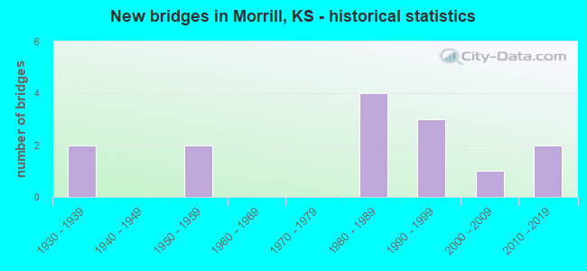
- New bridges - historical statistics
- 21930-1939
- 21950-1959
- 41980-1989
- 31990-1999
- 12000-2009
- 22010-2019
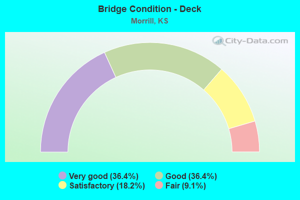
- Bridge Condition - Deck
- 36.4%Very good
- 36.4%Good
- 18.2%Satisfactory
- 9.1%Fair
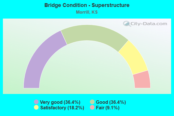
- Bridge Condition - Superstructure
- 36.4%Very good
- 36.4%Good
- 18.2%Satisfactory
- 9.1%Fair
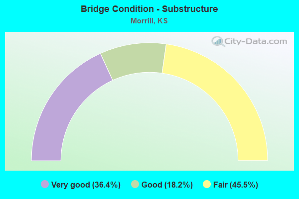
- Bridge Condition - Substructure
- 36.4%Very good
- 18.2%Good
- 45.5%Fair
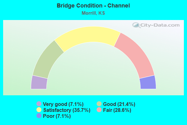
- Bridge Condition - Channel
- 7.1%Very good
- 21.4%Good
- 35.7%Satisfactory
- 28.6%Fair
- 7.1%Poor
Find on map >> Show street view
Structure Number: 7002, Location: 0.0E OF MORRILL (Lat: 39.928383, Lng: -95.690242), Route carried "on" structure: County highway 63, Year Built: 1984, Status: Open, Structure Length: 1.04m (3.41ft), Average Daily Traffic: 365 (year 2016), Truck Traffic: 10%, Average Future Daily Traffic: 400 (year 2042), Design Load: HS 20, Features Intersected: TERRAPIN CREEK
Minimum Vertical Clearance: 30.47m (99.97ft), Kilometerpoint: 1.000, Lanes on structure: 2, Owner: County Highway Agency, Approaching Roadway Width: 5.6m (18.4ft), Skew: 4 degrees, Material/Design: Concrete, Design/Construction: Culvert, Number Of Spans In Main Unit: 2, Length of Maximum Span: 4.9m (16.1ft), Curb-To-Curb Width: 7.9m (25.9ft), Out-to-Out Width: 7.9m (25.9ft)
Condition: Channel: Good, Culverts: Good, Operating Rating: 96.2 metric tons, Method Used To Determine Operating Rating: Load Factor (LF), Inventory Rating: 57.2 metric tons, Method Used To Determine Inventory Rating: Load Factor (LF), Structural Evaluation: Better than present minimum criteria, Deck Geometry: Somewhat better than minimum adequacy, Waterway Adequacy: Equal to present desirable criteria, Approach Roadway Alignment: Equal to present desirable criteria, Designated Inspection Frequency: Every 24 months, Inspection Date: January 2022, Wearing Surface/Protective System: Wearing Surface: Bituminous
Find on map >> Show street view
Structure Number: 70021, Location: 0.8E OF MORRILL (Lat: 39.928164, Lng: -95.671294), Route carried "on" structure: County highway 63, Year Built: 1935, Year Reconstructed: 1997, Status: Open, Structure Length: 1.71m (5.61ft), Average Daily Traffic: 365 (year 2016), Truck Traffic: 10%, Average Future Daily Traffic: 400 (year 2042), Design Load: HS 20, Features Intersected: TERRAPIN CREEK
Minimum Vertical Clearance: 30.47m (99.97ft), Kilometerpoint: 1.000, Lanes on structure: 2, Owner: County Highway Agency, Approaching Roadway Width: 6.0m (19.7ft), Skew: 3 degrees, Material/Design: Concrete, Design/Construction: Slab, Number Of Spans In Main Unit: 3, Length of Maximum Span: 5.5m (18.0ft), Curb-To-Curb Width: 7.7m (25.3ft), Out-to-Out Width: 8.3m (27.2ft)
Condition: Deck: Fair, Superstructure: Fair, Substructure: Fair, Channel: Fair, Operating Rating: 20.7 metric tons, Method Used To Determine Operating Rating: Allowable Stress (AS), Inventory Rating: 12.7 metric tons, Method Used To Determine Inventory Rating: Allowable Stress (AS), Structural Evaluation: Meets minimum limits, Deck Geometry: Somewhat better than minimum adequacy, Waterway Adequacy: Better than present minimum criteria, Approach Roadway Alignment: Equal to present desirable criteria, Length Of Structure Improvement: 2.41m (7.91ft), Designated Inspection Frequency: Every 24 months, Inspection Date: January 2022, Bridge Improvement Cost: $87,000, Roadway Improvement Cost: $9,000, Total Project Cost: $131,000, Deck Structure Type: Concrete Cast-file-Place, Wearing Surface/Protective System: Wearing Surface: Bituminous
Find on map >> Show street view
Structure Number: 70024, Location: 2.5N OF MORRILL (Lat: 39.969692, Lng: -95.693014), Route carried "on" structure: County highway 64, Year Built: 1955, Status: Open, Structure Length: 0.94m (3.08ft), Average Daily Traffic: 175 (year 2016), Truck Traffic: 10%, Average Future Daily Traffic: 225 (year 2042), Design Load: H 15, Features Intersected: TRIB. TO PONY CREEK
Minimum Vertical Clearance: 30.47m (99.97ft), Kilometerpoint: 1.000, Lanes on structure: 2, Owner: County Highway Agency, Approaching Roadway Width: 7.1m (23.3ft), Skew: 3 degrees, Material/Design: Concrete, Design/Construction: Culvert, Number Of Spans In Main Unit: 3, Length of Maximum Span: 2.4m (7.9ft), Curb-To-Curb Width: 7.9m (25.9ft), Out-to-Out Width: 8.5m (27.9ft)
Condition: Channel: Satisfactory, Culverts: Good, Operating Rating: 20.5 metric tons, Method Used To Determine Operating Rating: Load Factor (LF), Inventory Rating: 11.8 metric tons, Method Used To Determine Inventory Rating: Load Factor (LF), Structural Evaluation: Meets minimum limits, Deck Geometry: Somewhat better than minimum adequacy, Waterway Adequacy: Somewhat better than minimum adequacy, Approach Roadway Alignment: Equal to present desirable criteria, Length Of Structure Improvement: 0.94m (3.08ft), Designated Inspection Frequency: Every 24 months, Inspection Date: January 2022, Bridge Improvement Cost: $40,000, Roadway Improvement Cost: $5,000, Total Project Cost: $70,000, Wearing Surface/Protective System: Wearing Surface: Bituminous
Find on map >> Show street view
Structure Number: 70025, Location: 3.5N OF MORRILL (Lat: 39.984294, Lng: -95.692575), Route carried "on" structure: County highway 64, Year Built: 1950, Status: Open, Structure Length: 1.83m (6.00ft), Average Daily Traffic: 175 (year 2016), Truck Traffic: 10%, Average Future Daily Traffic: 225 (year 2042), Design Load: HS 20, Features Intersected: TRIB. TO PEDEE CREEK
Minimum Vertical Clearance: 30.47m (99.97ft), Kilometerpoint: 1.000, Lanes on structure: 2, Owner: County Highway Agency, Approaching Roadway Width: 6.6m (21.7ft), Material/Design: Steel, Design/Construction: Stringer/Multi-beam, Number Of Spans In Main Unit: 3, Length of Maximum Span: 6.7m (22.0ft), Curb-To-Curb Width: 6.7m (22.0ft), Out-to-Out Width: 7.5m (24.6ft)
Condition: Deck: Satisfactory, Superstructure: Satisfactory, Substructure: Fair, Channel: Fair, Operating Rating: 39.4 metric tons, Method Used To Determine Operating Rating: Load Factor (LF), Inventory Rating: 22.7 metric tons, Method Used To Determine Inventory Rating: Load Factor (LF), Structural Evaluation: Somewhat better than minimum adequacy, Deck Geometry: Meets minimum limits, Waterway Adequacy: Better than present minimum criteria, Approach Roadway Alignment: Equal to present desirable criteria, Designated Inspection Frequency: Every 24 months, Inspection Date: January 2022, Deck Structure Type: Concrete Cast-file-Place, Wearing Surface/Protective System: Wearing Surface: Bituminous
Find on map >> Show street view
Structure Number: 70B23, Location: 2.3N OF MORRILL (Lat: 39.965586, Lng: -95.693086), Route carried "on" structure: County highway 64, Year Built: 2019, Status: Open, Structure Length: 2.74m (8.99ft), Average Daily Traffic: 202 (year 2004), Truck Traffic: 10%, Average Future Daily Traffic: 224 (year 2042), Design Load: HL 93, Features Intersected: TRIB. TO PONY CREEK
Minimum Vertical Clearance: 30.47m (99.97ft), Kilometerpoint: 0.000, Lanes on structure: 2, Owner: County Highway Agency, Approaching Roadway Width: 7.3m (24.0ft), Material/Design: Steel, Design/Construction: Stringer/Multi-beam, Number Of Spans In Main Unit: 1, Length of Maximum Span: 27.0m (88.6ft), Curb or Sidewalk Widths: Left: 0.1m (0.3ft), Right: 0.1m (0.3ft), Curb-To-Curb Width: 7.9m (25.9ft), Out-to-Out Width: 8.1m (26.6ft)
Condition: Deck: Very good, Superstructure: Very good, Substructure: Very good, Channel: Good, Operating Rating: 72.5 metric tons, Method Used To Determine Operating Rating: Load and Resistance Factor (LRFR), Inventory Rating: 51.7 metric tons, Method Used To Determine Inventory Rating: Load and Resistance Factor (LRFR), Structural Evaluation: Equal to present desirable criteria, Deck Geometry: Somewhat better than minimum adequacy, Waterway Adequacy: Equal to present minimum criteria, Approach Roadway Alignment: Equal to present desirable criteria, Designated Inspection Frequency: Every 24 months, Inspection Date: January 2022, Deck Structure Type: Concrete Cast-file-Place
Find on map >> Show street view
Structure Number: 7099370302, Location: 4.0N 0.2W OF MORRILL (Lat: 39.986681, Lng: -95.698100), Route carried "on" structure: County highway , Year Built: 1983, Status: Open, Structure Length: 2.30m (7.55ft), Average Daily Traffic: 30 (year 2016), Average Future Daily Traffic: 33 (year 2042), Design Load: H 20, Features Intersected: PEDEE CREEK, Facility Carried by Structure: 330th St.
Minimum Vertical Clearance: 30.47m (99.97ft), Kilometerpoint: 1.000, Lanes on structure: 2, Owner: County Highway Agency, Approaching Roadway Width: 4.6m (15.1ft), Material/Design: Concrete continuous, Design/Construction: Slab, Number Of Spans In Main Unit: 3, Length of Maximum Span: 9.1m (29.9ft), Curb-To-Curb Width: 7.3m (24.0ft), Out-to-Out Width: 7.9m (25.9ft)
Condition: Deck: Good, Superstructure: Good, Substructure: Fair, Channel: Poor, Operating Rating: 32.7 metric tons, Method Used To Determine Operating Rating: Field evaluation and documented engineering judgment, Inventory Rating: 32.7 metric tons, Method Used To Determine Inventory Rating: Field evaluation and documented engineering judgment, Structural Evaluation: Somewhat better than minimum adequacy, Deck Geometry: Equal to present minimum criteria, Waterway Adequacy: Equal to present minimum criteria, Approach Roadway Alignment: Equal to present desirable criteria, Length Of Structure Improvement: 2.32m (7.61ft), Designated Inspection Frequency: Every 24 months, Inspection Date: January 2022, Other Special Inspection Date: September 2021, Bridge Improvement Cost: $80,000, Roadway Improvement Cost: $25,000, Total Project Cost: $125,000, Deck Structure Type: Concrete Cast-file-Place
Find on map >> Show street view
Structure Number: 70995003102, Location: 0.1S OF MORILL (Lat: 39.926131, Lng: -95.693939), Route carried "on" structure: County highway , Year Built: 1935, Status: Open, Structure Length: 0.98m (3.22ft), Average Daily Traffic: 75 (year 2016), Average Future Daily Traffic: 82 (year 2042), Design Load: HS 20, Features Intersected: TRIB. TO TERRAPIN CREEK, Facility Carried by Structure: Dewberry Rd.
Minimum Vertical Clearance: 30.47m (99.97ft), Kilometerpoint: 1.000, Lanes on structure: 2, Owner: County Highway Agency, Approaching Roadway Width: 5.7m (18.7ft), Material/Design: Steel, Design/Construction: Stringer/Multi-beam, Number Of Spans In Main Unit: 1, Length of Maximum Span: 9.1m (29.9ft), Curb-To-Curb Width: 7.6m (24.9ft), Out-to-Out Width: 8.5m (27.9ft)
Condition: Deck: Satisfactory, Superstructure: Satisfactory, Substructure: Fair, Channel: Fair, Operating Rating: 36.9 metric tons, Method Used To Determine Operating Rating: Allowable Stress (AS), Inventory Rating: 20.9 metric tons, Method Used To Determine Inventory Rating: Allowable Stress (AS), Structural Evaluation: Somewhat better than minimum adequacy, Deck Geometry: Equal to present minimum criteria, Waterway Adequacy: Equal to present minimum criteria, Approach Roadway Alignment: Equal to present desirable criteria, Length Of Structure Improvement: 1.13m (3.71ft), Designated Inspection Frequency: Every 24 months, Inspection Date: January 2022, Bridge Improvement Cost: $42,000, Roadway Improvement Cost: $4,000, Total Project Cost: $63,000, Deck Structure Type: Concrete Cast-file-Place, Wearing Surface/Protective System: Wearing Surface: Bituminous
Find on map >> Show street view
Structure Number: 7099580304, Location: 2.7N 0.8E OF MORRILL (Lat: 39.971756, Lng: -95.675714), Route carried "on" structure: County highway , Year Built: 1984, Status: Open, Structure Length: 0.91m (2.99ft), Average Daily Traffic: 40 (year 2016), Average Future Daily Traffic: 44 (year 2042), Design Load: H 20, Features Intersected: TRIB. TO PONY CREEK, Facility Carried by Structure: 320th St.
Minimum Vertical Clearance: 30.47m (99.97ft), Kilometerpoint: 1.000, Lanes on structure: 2, Owner: County Highway Agency, Approaching Roadway Width: 3.9m (12.8ft), Skew: 3 degrees, Material/Design: Concrete, Design/Construction: Culvert, Number Of Spans In Main Unit: 1, Length of Maximum Span: 9.1m (29.9ft), Curb-To-Curb Width: 7.8m (25.6ft), Out-to-Out Width: 8.4m (27.6ft)
Condition: Channel: Satisfactory, Culverts: Good, Operating Rating: 32.7 metric tons, Method Used To Determine Operating Rating: Field evaluation and documented engineering judgment, Inventory Rating: 32.7 metric tons, Method Used To Determine Inventory Rating: Field evaluation and documented engineering judgment, Structural Evaluation: Better than present minimum criteria, Deck Geometry: Equal to present minimum criteria, Waterway Adequacy: Equal to present minimum criteria, Approach Roadway Alignment: Equal to present desirable criteria, Length Of Structure Improvement: 0.91m (2.99ft), Designated Inspection Frequency: Every 24 months, Inspection Date: January 2022, Other Special Inspection Date: September 2021, Bridge Improvement Cost: $40,000, Roadway Improvement Cost: $8,000, Total Project Cost: $55,000, Wearing Surface/Protective System: Wearing Surface: Gravel
Find on map >> Show street view
Structure Number: 70997003022, Location: 0.8E 3.0N OF MORILL (Lat: 39.984122, Lng: -95.673603), Route carried "on" structure: County highway , Year Built: 2006, Status: Open, Structure Length: 2.74m (8.99ft), Average Daily Traffic: 40 (year 2016), Average Future Daily Traffic: 44 (year 2042), Design Load: HS 20, Features Intersected: TRIB. TO PONY CREEK, Facility Carried by Structure: Falcon Rd.
Minimum Vertical Clearance: 30.47m (99.97ft), Kilometerpoint: 1.000, Lanes on structure: 2, Owner: County Highway Agency, Approaching Roadway Width: 6.0m (19.7ft), Material/Design: Concrete continuous, Design/Construction: Slab, Number Of Spans In Main Unit: 3, Length of Maximum Span: 10.8m (35.4ft), Curb-To-Curb Width: 8.0m (26.2ft), Out-to-Out Width: 8.6m (28.2ft)
Condition: Deck: Very good, Superstructure: Very good, Substructure: Very good, Channel: Satisfactory, Operating Rating: 76.5 metric tons, Method Used To Determine Operating Rating: Load Factor (LF), Inventory Rating: 45.4 metric tons, Method Used To Determine Inventory Rating: Load Factor (LF), Structural Evaluation: Equal to present desirable criteria, Deck Geometry: Equal to present minimum criteria, Waterway Adequacy: Equal to present desirable criteria, Approach Roadway Alignment: Equal to present desirable criteria, Designated Inspection Frequency: Every 24 months, Inspection Date: January 2022, Deck Structure Type: Concrete Cast-file-Place
Find on map >> Show street view
Structure Number: 70997003028, Location: 0.8E 3.2N OF MORRILL (Lat: 39.976361, Lng: -95.673900), Route carried "on" structure: County highway , Year Built: 1999, Status: Open, Structure Length: 3.57m (11.71ft), Average Daily Traffic: 64 (year 2016), Average Future Daily Traffic: 64 (year 2042), Design Load: HS 20, Features Intersected: PONY CREEK, Facility Carried by Structure: Falcon Rd.
Minimum Vertical Clearance: 30.47m (99.97ft), Kilometerpoint: 1.000, Lanes on structure: 2, Owner: County Highway Agency, Approaching Roadway Width: 5.4m (17.7ft), Material/Design: Concrete continuous, Design/Construction: Slab, Number Of Spans In Main Unit: 3, Length of Maximum Span: 14.0m (45.9ft), Curb-To-Curb Width: 7.4m (24.3ft), Out-to-Out Width: 8.7m (28.5ft)
Condition: Deck: Very good, Superstructure: Very good, Substructure: Very good, Channel: Good, Operating Rating: 69.3 metric tons, Method Used To Determine Operating Rating: Allowable Stress (AS), Inventory Rating: 40.8 metric tons, Method Used To Determine Inventory Rating: Allowable Stress (AS), Structural Evaluation: Equal to present desirable criteria, Deck Geometry: Equal to present minimum criteria, Waterway Adequacy: Better than present minimum criteria, Approach Roadway Alignment: Equal to present desirable criteria, Length Of Structure Improvement: 3.57m (11.71ft), Designated Inspection Frequency: Every 24 months, Inspection Date: January 2022, Bridge Improvement Cost: $167,000, Roadway Improvement Cost: $20,000, Total Project Cost: $200,000, Deck Structure Type: Concrete Cast-file-Place
Find on map >> Show street view
Structure Number: 70997003087, Location: 0.8E 0.4N OF MORILL (Lat: 39.932417, Lng: -95.674953), Route carried "on" structure: County highway , Year Built: 1980, Status: Open, Structure Length: 0.98m (3.22ft), Average Daily Traffic: 45 (year 2016), Average Future Daily Traffic: 49 (year 2042), Design Load: H 20, Features Intersected: UNNAMED STREAM, Facility Carried by Structure: Falcon Rd.
Minimum Vertical Clearance: 30.47m (99.97ft), Kilometerpoint: 1.000, Lanes on structure: 2, Owner: County Highway Agency, Approaching Roadway Width: 4.1m (13.5ft), Material/Design: Steel, Design/Construction: Stringer/Multi-beam, Number Of Spans In Main Unit: 1, Length of Maximum Span: 9.1m (29.9ft), Curb-To-Curb Width: 8.4m (27.6ft), Out-to-Out Width: 8.5m (27.9ft)
Condition: Deck: Good, Superstructure: Good, Substructure: Good, Channel: Satisfactory, Inventory Rating: 75.3 metric tons, Method Used To Determine Inventory Rating: Load Factor (LF), Structural Evaluation: Better than present minimum criteria, Deck Geometry: Equal to present minimum criteria, Waterway Adequacy: Better than present minimum criteria, Approach Roadway Alignment: Equal to present desirable criteria, Designated Inspection Frequency: Every 24 months, Inspection Date: January 2022, Deck Structure Type: Concrete Cast-file-Place
Find on map >> Show street view
Structure Number: 70997003167, Location: 2.5E 2.4N OF FAIRVIEW (Lat: 39.876019, Lng: -95.676261), Route carried "on" structure: County highway 705, Year Built: 2017, Status: Open, Structure Length: 3.12m (10.24ft), Average Daily Traffic: 45 (year 2004), Average Future Daily Traffic: 49 (year 2042), Design Load: HL 93, Features Intersected: MULBERRY CREEK, Facility Carried by Structure: Falcon Rd.
Minimum Vertical Clearance: 30.47m (99.97ft), Kilometerpoint: 0.000, Lanes on structure: 2, Owner: County Highway Agency, Approaching Roadway Width: 6.0m (19.7ft), Material/Design: Concrete continuous, Design/Construction: Slab, Number Of Spans In Main Unit: 3, Length of Maximum Span: 12.2m (40.0ft), Curb or Sidewalk Widths: Left: 0.3m (1.0ft), Right: 0.3m (1.0ft), Curb-To-Curb Width: 7.9m (25.9ft), Out-to-Out Width: 8.5m (27.9ft)
Condition: Deck: Very good, Superstructure: Very good, Substructure: Very good, Channel: Very good, Operating Rating: 50.2 metric tons, Method Used To Determine Operating Rating: Load and Resistance Factor (LRFR), Inventory Rating: 39.0 metric tons, Method Used To Determine Inventory Rating: Load and Resistance Factor (LRFR), Structural Evaluation: Equal to present desirable criteria, Deck Geometry: Equal to present minimum criteria, Waterway Adequacy: Equal to present desirable criteria, Approach Roadway Alignment: Equal to present desirable criteria, Designated Inspection Frequency: Every 24 months, Inspection Date: January 2022, Deck Structure Type: Concrete Cast-file-Place
Find on map >> Show street view
Structure Number: 70999003028, Location: 1.8E 3.2N OF MORRILL (Lat: 39.975308, Lng: -95.658486), Route carried "on" structure: County highway , Year Built: 1991, Status: Open, Structure Length: 4.02m (13.19ft), Average Daily Traffic: 40 (year 2016), Average Future Daily Traffic: 44 (year 2042), Design Load: HS 20, Features Intersected: PONY CREEK, Facility Carried by Structure: Foxtail Rd.
Minimum Vertical Clearance: 30.47m (99.97ft), Kilometerpoint: 1.000, Lanes on structure: 2, Owner: County Highway Agency, Approaching Roadway Width: 4.6m (15.1ft), Material/Design: Concrete continuous, Design/Construction: Slab, Number Of Spans In Main Unit: 3, Length of Maximum Span: 15.8m (51.8ft), Curb-To-Curb Width: 7.3m (24.0ft), Out-to-Out Width: 7.9m (25.9ft)
Condition: Deck: Good, Superstructure: Good, Substructure: Fair, Channel: Fair, Operating Rating: 70.2 metric tons, Method Used To Determine Operating Rating: Allowable Stress (AS), Inventory Rating: 41.7 metric tons, Method Used To Determine Inventory Rating: Allowable Stress (AS), Structural Evaluation: Somewhat better than minimum adequacy, Deck Geometry: Equal to present minimum criteria, Waterway Adequacy: Equal to present minimum criteria, Approach Roadway Alignment: Equal to present desirable criteria, Length Of Structure Improvement: 4.02m (13.19ft), Designated Inspection Frequency: Every 24 months, Inspection Date: January 2022, Bridge Improvement Cost: $65,000, Roadway Improvement Cost: $8,000, Total Project Cost: $95,000, Deck Structure Type: Concrete Cast-file-Place
Find on map >> Show street view
Structure Number: 7099920304, Location: 0.3S 4.8W OF RESERVE (Lat: 39.971836, Lng: -95.657086), Route carried "on" structure: County highway , Year Built: 1995, Status: Open, Structure Length: 0.93m (3.05ft), Average Daily Traffic: 40 (year 2016), Average Future Daily Traffic: 44 (year 2042), Design Load: HS 20, Features Intersected: UNNAMED STREAM, Facility Carried by Structure: 320th St.
Minimum Vertical Clearance: 30.47m (99.97ft), Kilometerpoint: 1.000, Lanes on structure: 2, Owner: County Highway Agency, Approaching Roadway Width: 4.7m (15.4ft), Material/Design: Steel, Design/Construction: Stringer/Multi-beam, Number Of Spans In Main Unit: 1, Length of Maximum Span: 8.7m (28.5ft), Curb or Sidewalk Widths: Left: 0.1m (0.3ft), Right: 0.1m (0.3ft), Curb-To-Curb Width: 7.3m (24.0ft), Out-to-Out Width: 7.5m (24.6ft)
Condition: Deck: Good, Superstructure: Good, Substructure: Good, Channel: Satisfactory, Operating Rating: 53.8 metric tons, Method Used To Determine Operating Rating: Load Factor (LF), Inventory Rating: 31.8 metric tons, Method Used To Determine Inventory Rating: Load Factor (LF), Structural Evaluation: Better than present minimum criteria, Deck Geometry: Equal to present minimum criteria, Waterway Adequacy: Equal to present minimum criteria, Approach Roadway Alignment: Equal to present desirable criteria, Designated Inspection Frequency: Every 24 months, Inspection Date: January 2022, Deck Structure Type: Concrete Cast-file-Place