Bridge Statistics for Mount Pleasant, Pennsylvania (PA)
Condition, Traffic, Stress, Structural Evaluation, Project Costs
- National Bridge Inventory (NBI) Statistics
- 40Number of bridges
- 262ft / 79.8mTotal length
- $11,487,000Total costs
- 403,951Total average daily traffic
- 97,952Total average daily truck traffic
- National Bridge Inventory (NBI) Registered Bridges for Mount Pleasant
- No street view available for this location
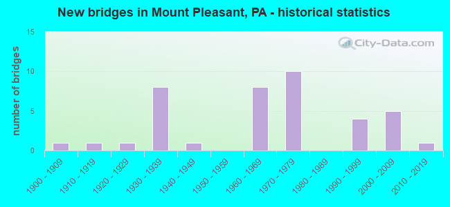
- New bridges - historical statistics
- 11900-1909
- 11910-1919
- 11920-1929
- 81930-1939
- 11940-1949
- 81960-1969
- 101970-1979
- 41990-1999
- 52000-2009
- 12010-2019
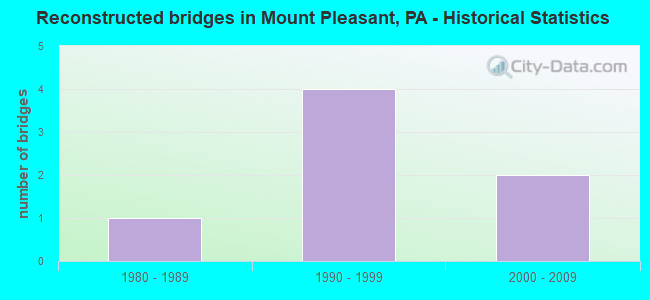
- Reconstructed bridges - Historical Statistics
- 11980-1989
- 41990-1999
- 22000-2009
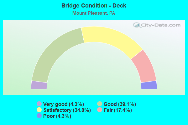
- Bridge Condition - Deck
- 4.3%Very good
- 39.1%Good
- 34.8%Satisfactory
- 17.4%Fair
- 4.3%Poor
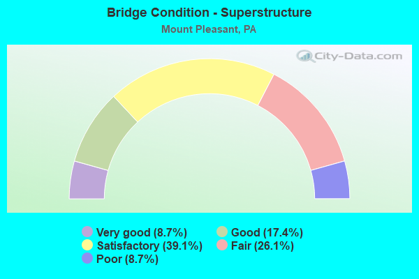
- Bridge Condition - Superstructure
- 8.7%Very good
- 17.4%Good
- 39.1%Satisfactory
- 26.1%Fair
- 8.7%Poor
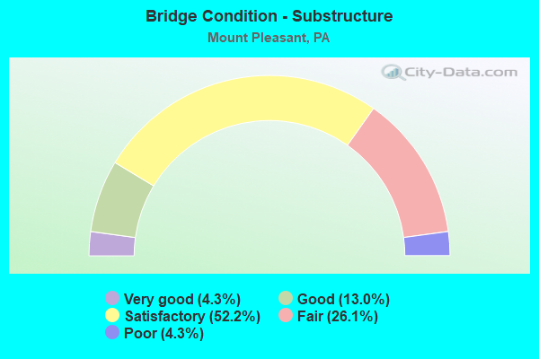
- Bridge Condition - Substructure
- 4.3%Very good
- 13.0%Good
- 52.2%Satisfactory
- 26.1%Fair
- 4.3%Poor
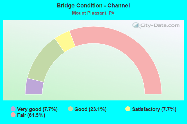
- Bridge Condition - Channel
- 7.7%Very good
- 23.1%Good
- 7.7%Satisfactory
- 61.5%Fair
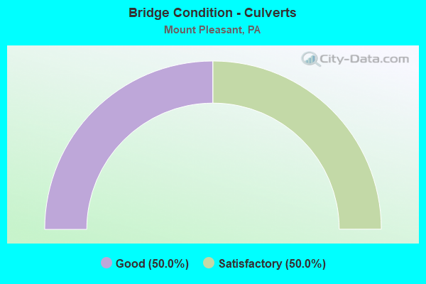
- Bridge Condition - Culverts
- 50.0%Good
- 50.0%Satisfactory
Find on map >> Show street view
Structure Number: 5941, Location: JUNIATA 8TH.ST.BRIDGE (Lat: 40.538206, Lng: -78.377706), Route carried "on" structure: City street , Year Built: 1979, Year Reconstructed: 2012, Status: Open, Structure Length: 8.02m (26.31ft), Average Daily Traffic: 10,200 (year 2020), Truck Traffic: 1%, Average Future Daily Traffic: 12,750 (year 2040), Design Load: HS 20, Features Intersected: NORFOLK SOUTHERN RR, Facility Carried by Structure: T473, N. Eighth St
Minimum Vertical Clearance: 30+ m (98+ ft), Kilometerpoint: 0.000, Lanes on structure: 2, Owner: County Highway Agency, Approaching Roadway Width: 9.1m (29.9ft), Material/Design: Prestressed concrete, Design/Construction: Box Beam or Girders - Multiple, Number Of Spans In Main Unit: 4, Length of Maximum Span: 26.2m (86.0ft), Curb or Sidewalk Widths: Left: 0.2m (0.7ft), Right: 1.5m (4.9ft), Curb-To-Curb Width: 9.1m (29.9ft), Out-to-Out Width: 11.1m (36.4ft)
Condition: Deck: Good, Superstructure: Fair, Substructure: Satisfactory, Operating Rating: 80.7 metric tons, Method Used To Determine Operating Rating: Load Factor (LF), Inventory Rating: 6.4 metric tons, Method Used To Determine Inventory Rating: Load Factor (LF), Structural Evaluation: High priority of corrective action, Deck Geometry: Meets minimum limits, Underclear: High priority of corrective action, Approach Roadway Alignment: Equal to present desirable criteria, Length Of Structure Improvement: 9.00m (29.53ft), Designated Inspection Frequency: Every 24 months, Inspection Date: June 2020, Wearing Surface/Protective System: Wearing Surface: Epoxy Overlay, Deck Protection: Epoxy Coated Reinforcing
Find on map >> Show street view
Structure Number: 5961, Location: 4 MI.SE.OF TYRONE (Lat: 40.631656, Lng: -78.185744), Route carried "on" structure: City street , Year Built: 1937, Status: Open, Structure Length: 3.75m (12.30ft), Average Daily Traffic: 11 (year 2021), Average Future Daily Traffic: 19 (year 2041), Design Load: H 10, Features Intersected: LITTLE JUNIATA RIVER, Facility Carried by Structure: T506,Church Hill R
Minimum Vertical Clearance: 30+ m (98+ ft), Kilometerpoint: 0.000, Lanes on structure: 1, Owner: County Highway Agency, Approaching Roadway Width: 3.0m (9.8ft), Material/Design: Steel, Design/Construction: Stringer/Multi-beam, Number Of Spans In Main Unit: 2, Length of Maximum Span: 17.4m (57.1ft), Curb or Sidewalk Widths: Left: 0.1m (0.3ft), Right: 0.1m (0.3ft), Curb-To-Curb Width: 3.8m (12.5ft), Out-to-Out Width: 4.3m (14.1ft)
Condition: Deck: Satisfactory, Superstructure: Fair, Substructure: Satisfactory, Channel: Fair, Operating Rating: 48.1 metric tons, Method Used To Determine Operating Rating: Load Factor (LF), Inventory Rating: 29.0 metric tons, Method Used To Determine Inventory Rating: Load Factor (LF), Structural Evaluation: Somewhat better than minimum adequacy, Deck Geometry: Meets minimum limits, Waterway Adequacy: Better than present minimum criteria, Approach Roadway Alignment: Somewhat better than minimum adequacy, Length Of Structure Improvement: 4.70m (15.42ft), Designated Inspection Frequency: Every 24 months, Inspection Date: September 2021, Bridge Improvement Cost: $114,000, Roadway Improvement Cost: $335,000, Total Project Cost: $1,536,000, Deck Structure Type: Wood or Timber, Wearing Surface/Protective System: Wearing Surface: Bituminous
Find on map >> Show street view
Structure Number: 5969, Location: 1.5 MI.SE.OF WILLIAMSBURG (Lat: 40.454711, Lng: -78.173108), Route carried "on" structure: City street , Year Built: 1915, Status: Posted for load, Structure Length: 1.86m (6.10ft), Average Daily Traffic: 67 (year 2021), Truck Traffic: 1%, Average Future Daily Traffic: 86 (year 2041), Features Intersected: CLOVER CREEK, Facility Carried by Structure: T435, Blue Hole Rd
Minimum Vertical Clearance: 30+ m (98+ ft), Kilometerpoint: 0.000, Lanes on structure: 2, Owner: County Highway Agency, Approaching Roadway Width: 4.3m (14.1ft), Skew: 4 degrees, Material/Design: Concrete, Number Of Spans In Main Unit: 1, Length of Maximum Span: 18.0m (59.1ft), Curb-To-Curb Width: 5.0m (16.4ft), Out-to-Out Width: 5.0m (16.4ft)
Condition: Deck: Fair, Superstructure: Poor, Substructure: Fair, Channel: Good, Operating Rating: 15.4 metric tons, Method Used To Determine Operating Rating: Field evaluation and documented engineering judgment, Inventory Rating: 9.1 metric tons, Method Used To Determine Inventory Rating: Field evaluation and documented engineering judgment, Structural Evaluation: High priority of replacement, Deck Geometry: High priority of corrective action, Waterway Adequacy: Equal to present desirable criteria, Approach Roadway Alignment: Equal to present minimum criteria, Bridge Posting: Required (Relationship of Operating Rating to Maximum Legal Load: > 39.9% below), Length Of Structure Improvement: 2.30m (7.55ft), Designated Inspection Frequency: Every 24 months, Other Special Inspection Frequency: Every 12 months, Inspection Date: November 2019, Other Special Inspection Date: November 2020, Bridge Improvement Cost: $66,000, Roadway Improvement Cost: $264,000, Total Project Cost: $892,000, Deck Structure Type: Concrete Cast-file-Place, Wearing Surface/Protective System: Wearing Surface: Bituminous
Find on map >> Show street view
Structure Number: 1671, Location: BULLSKIN TOWNSHIP (Lat: 40.110356, Lng: -79.515278), Route carried "on" structure: State highway 982, Year Built: 1930, Status: Open, Structure Length: 0.85m (2.79ft), Average Daily Traffic: 4,445 (year 2022), Truck Traffic: 13%, Average Future Daily Traffic: 4,558 (year 2032), Design Load: H 20, Features Intersected: GREEN LICK RUN
Minimum Vertical Clearance: 30+ m (98+ ft), Kilometerpoint: 7.380, Lanes on structure: 2, Owner: State Highway Agency, Approaching Roadway Width: 9.1m (29.9ft), Skew: 3 degrees, Material/Design: Concrete, Design/Construction: Tee Beam, Number Of Spans In Main Unit: 1, Length of Maximum Span: 7.9m (25.9ft), Curb-To-Curb Width: 9.1m (29.9ft), Out-to-Out Width: 10.1m (33.1ft)
Condition: Deck: Fair, Superstructure: Fair, Substructure: Satisfactory, Channel: Fair, Operating Rating: 57.2 metric tons, Method Used To Determine Operating Rating: Load Factor (LF), Inventory Rating: 33.6 metric tons, Method Used To Determine Inventory Rating: Load Factor (LF), Structural Evaluation: Somewhat better than minimum adequacy, Deck Geometry: Meets minimum limits, Waterway Adequacy: Equal to present minimum criteria, Approach Roadway Alignment: Equal to present desirable criteria, Length Of Structure Improvement: 1.50m (4.92ft), Designated Inspection Frequency: Every 24 months, Inspection Date: January 2021, Bridge Improvement Cost: $22,000, Roadway Improvement Cost: $65,000, Total Project Cost: $297,000, Deck Structure Type: Concrete Cast-file-Place, Wearing Surface/Protective System: Wearing Surface: Bituminous
Find on map >> Show street view
Structure Number: 16735, Location: BULLSKIN TOWNSHIP (Lat: 40.137222, Lng: -79.509872), Route carried "on" structure: State highway , Year Built: 1923, Year Reconstructed: 2012, Status: Open, Structure Length: 1.80m (5.91ft), Average Daily Traffic: 509 (year 2020), Truck Traffic: 5%, Average Future Daily Traffic: 664 (year 2042), Design Load: H 20, Features Intersected: JACOBS CREEK, Facility Carried by Structure: SR 1013
Minimum Vertical Clearance: 30+ m (98+ ft), Kilometerpoint: 0.000, Lanes on structure: 1, Owner: State Highway Agency, Approaching Roadway Width: 4.3m (14.1ft), Material/Design: Concrete, Design/Construction: Tee Beam, Number Of Spans In Main Unit: 2, Length of Maximum Span: 8.5m (27.9ft), Curb-To-Curb Width: 3.0m (9.8ft), Out-to-Out Width: 5.0m (16.4ft)
Condition: Deck: Good, Superstructure: Satisfactory, Substructure: Satisfactory, Channel: Fair, Inventory Rating: 94.3 metric tons, Method Used To Determine Inventory Rating: Allowable Stress (AS), Structural Evaluation: Equal to present minimum criteria, Deck Geometry: High priority of replacement, Waterway Adequacy: High priority of corrective action, Approach Roadway Alignment: Meets minimum limits, Length Of Structure Improvement: 2.40m (7.87ft), Designated Inspection Frequency: Every 48 months, Inspection Date: January 2021, Bridge Improvement Cost: $43,000, Roadway Improvement Cost: $126,000, Total Project Cost: $579,000, Deck Structure Type: Concrete Cast-file-Place, Wearing Surface/Protective System: Wearing Surface: Bituminous
Find on map >> Show street view
Structure Number: 35979, Location: EAST HUNTINGDON TOWNSHIP (Lat: 40.154664, Lng: -79.561125), Route carried "on" structure: State highway 31, Year Built: 1963, Status: Open, Structure Length: 4.30m (14.11ft), Average Daily Traffic: 8,374 (year 2020), Truck Traffic: 14%, Average Future Daily Traffic: 13,348 (year 2032), Design Load: HS 20+Mod, Features Intersected: SR 0119
Minimum Vertical Clearance: 30+ m (98+ ft), Kilometerpoint: 17.825, Lanes on structure: 4, Lanes under structure: 8, Owner: State Highway Agency, Approaching Roadway Width: 21.3m (69.9ft), Skew: 20 degrees, Material/Design: Prestressed concrete, Design/Construction: Box Beam or Girders - Multiple, Number Of Spans In Main Unit: 3, Length of Maximum Span: 25.0m (82.0ft), Curb-To-Curb Width: 21.2m (69.6ft), Out-to-Out Width: 22.4m (73.5ft)
Condition: Deck: Satisfactory, Superstructure: Satisfactory, Substructure: Satisfactory, Inventory Rating: 62.6 metric tons, Method Used To Determine Inventory Rating: Load Factor (LF), Structural Evaluation: Equal to present minimum criteria, Deck Geometry: Superior to present desirable criteria, Underclear: Equal to present minimum criteria, Approach Roadway Alignment: Equal to present desirable criteria, Length Of Structure Improvement: 4.90m (16.08ft), Designated Inspection Frequency: Every 24 months, Inspection Date: April 2021, Bridge Improvement Cost: $127,000, Roadway Improvement Cost: $375,000, Total Project Cost: $1,717,000, Deck Structure Type: Concrete Cast-file-Place, Wearing Surface/Protective System: Wearing Surface: Epoxy Overlay
Find on map >> Show street view
Structure Number: 35981, Location: MOUNT PLEASANT TOWNSHIP (Lat: 40.144564, Lng: -79.509025), Route carried "on" structure: State highway 31, Year Built: 1948, Status: Open, Structure Length: 1.16m (3.81ft), Average Daily Traffic: 7,552 (year 2020), Truck Traffic: 11%, Average Future Daily Traffic: 12,173 (year 2032), Design Load: HS 20, Features Intersected: BRUSH RUN
Minimum Vertical Clearance: 30+ m (98+ ft), Kilometerpoint: 22.785, Lanes on structure: 2, Base Highway Network: Yes, Owner: State Highway Agency, Approaching Roadway Width: 6.7m (22.0ft), Skew: 1 degrees, Material/Design: Concrete, Design/Construction: Tee Beam, Number Of Spans In Main Unit: 1, Length of Maximum Span: 11.0m (36.1ft), Curb-To-Curb Width: 11.9m (39.0ft), Out-to-Out Width: 12.5m (41.0ft)
Condition: Deck: Satisfactory, Superstructure: Good, Substructure: Satisfactory, Channel: Fair, Operating Rating: 56.2 metric tons, Method Used To Determine Operating Rating: Load Factor (LF), Inventory Rating: 33.6 metric tons, Method Used To Determine Inventory Rating: Load Factor (LF), Structural Evaluation: Equal to present minimum criteria, Deck Geometry: Somewhat better than minimum adequacy, Waterway Adequacy: Superior to present desirable criteria, Approach Roadway Alignment: Equal to present desirable criteria, Length Of Structure Improvement: 1.20m (3.94ft), Designated Inspection Frequency: Every 24 months, Inspection Date: April 2021, Bridge Improvement Cost: $36,000, Roadway Improvement Cost: $150,000, Total Project Cost: $485,000, Deck Structure Type: Concrete Cast-file-Place, Wearing Surface/Protective System: Wearing Surface: Bituminous, Membrane: Preformed Fabric
Find on map >> Show street view
Structure Number: 36076, Location: EAST HUNTINGDON TOWNSHIP (Lat: 40.183139, Lng: -79.566711), Route carried "on" structure: US 119, Year Built: 1977, Status: Open, Structure Length: 4.54m (14.90ft), Average Daily Traffic: 11,606 (year 2022), Truck Traffic: 14%, Average Future Daily Traffic: 8,720 (year 2032), Design Load: HS 20, Features Intersected: SW PA R/R & PVT RD
Minimum Vertical Clearance: 30+ m (98+ ft), Kilometerpoint: 8.146, Lanes on structure: 2, Lanes under structure: 2, Base Highway Network: Yes, Owner: State Highway Agency, Approaching Roadway Width: 12.8m (42.0ft), Skew: 10 degrees, Material/Design: Prestressed concrete, Design/Construction: Box Beam or Girders - Single/Spread, Number Of Spans In Main Unit: 3, Length of Maximum Span: 14.6m (47.9ft), Curb or Sidewalk Widths: Left: 0.2m (0.7ft), Right: 0.2m (0.7ft), Curb-To-Curb Width: 12.8m (42.0ft), Out-to-Out Width: 13.9m (45.6ft)
Condition: Deck: Satisfactory, Superstructure: Satisfactory, Substructure: Satisfactory, Inventory Rating: 59.0 metric tons, Method Used To Determine Inventory Rating: Load Factor (LF), Structural Evaluation: Equal to present minimum criteria, Deck Geometry: Equal to present desirable criteria, Underclear: Superior to present desirable criteria, Approach Roadway Alignment: Equal to present desirable criteria, Length Of Structure Improvement: 5.50m (18.04ft), Designated Inspection Frequency: Every 24 months, Inspection Date: May 2021, Deck Structure Type: Concrete Cast-file-Place, Wearing Surface/Protective System: Wearing Surface: Monolithic Concrete, Deck Protection: Galvanized Reinforcing
Find on map >> Show street view
Structure Number: 36077, Location: EAST HUNTINGDON TOWNSHIP (Lat: 40.183317, Lng: -79.566833), Route carried "on" structure: US 119, Year Built: 1977, Status: Open, Structure Length: 4.54m (14.90ft), Average Daily Traffic: 11,266 (year 2022), Truck Traffic: 13%, Average Future Daily Traffic: 9,495 (year 2032), Design Load: HS 20, Features Intersected: SW PA R/R & PVT RD
Minimum Vertical Clearance: 30+ m (98+ ft), Kilometerpoint: 8.142, Lanes on structure: 2, Lanes under structure: 2, Base Highway Network: Yes, Owner: State Highway Agency, Approaching Roadway Width: 12.8m (42.0ft), Skew: 10 degrees, Material/Design: Prestressed concrete, Design/Construction: Box Beam or Girders - Single/Spread, Number Of Spans In Main Unit: 3, Length of Maximum Span: 14.6m (47.9ft), Curb or Sidewalk Widths: Left: 0.2m (0.7ft), Right: 0.2m (0.7ft), Curb-To-Curb Width: 12.8m (42.0ft), Out-to-Out Width: 13.9m (45.6ft)
Condition: Deck: Satisfactory, Superstructure: Satisfactory, Substructure: Satisfactory, Inventory Rating: 56.2 metric tons, Method Used To Determine Inventory Rating: Load Factor (LF), Structural Evaluation: Equal to present minimum criteria, Deck Geometry: Equal to present desirable criteria, Underclear: Superior to present desirable criteria, Approach Roadway Alignment: Equal to present desirable criteria, Length Of Structure Improvement: 5.50m (18.04ft), Designated Inspection Frequency: Every 24 months, Inspection Date: May 2021, Deck Structure Type: Concrete Cast-file-Place, Wearing Surface/Protective System: Wearing Surface: Monolithic Concrete, Deck Protection: Galvanized Reinforcing
Find on map >> Show street view
Structure Number: 36301, Location: EAST HUNTINGDON TOWNSHIP (Lat: 40.148194, Lng: -79.562244), Route carried "on" structure: State highway 981, Year Built: 1963, Status: Open, Structure Length: 1.68m (5.51ft), Average Daily Traffic: 1,627 (year 2020), Truck Traffic: 11%, Average Future Daily Traffic: 3,033 (year 2032), Design Load: HS 20+Mod, Features Intersected: SHERRICK RUN
Minimum Vertical Clearance: 30+ m (98+ ft), Kilometerpoint: 20.839, Lanes on structure: 2, Owner: State Highway Agency, Approaching Roadway Width: 6.7m (22.0ft), Skew: 2 degrees, Material/Design: Prestressed concrete, Design/Construction: Box Beam or Girders - Single/Spread, Number Of Spans In Main Unit: 1, Length of Maximum Span: 15.8m (51.8ft), Curb or Sidewalk Widths: Left: 0.4m (1.3ft), Right: 0.4m (1.3ft), Curb-To-Curb Width: 11.6m (38.1ft), Out-to-Out Width: 14.2m (46.6ft)
Condition: Deck: Satisfactory, Superstructure: Satisfactory, Substructure: Satisfactory, Channel: Fair, Operating Rating: 55.3 metric tons, Method Used To Determine Operating Rating: Load Factor (LF), Inventory Rating: 32.7 metric tons, Method Used To Determine Inventory Rating: Load Factor (LF), Structural Evaluation: Equal to present minimum criteria, Deck Geometry: Equal to present minimum criteria, Waterway Adequacy: Superior to present desirable criteria, Approach Roadway Alignment: Equal to present desirable criteria, Length Of Structure Improvement: 1.60m (5.25ft), Designated Inspection Frequency: Every 24 months, Inspection Date: July 2021, Bridge Improvement Cost: $23,000, Roadway Improvement Cost: $200,000, Total Project Cost: $306,000, Deck Structure Type: Concrete Cast-file-Place, Wearing Surface/Protective System: Wearing Surface: Monolithic Concrete
Find on map >> Show street view
Structure Number: 36302, Location: EAST HUNTINGDON TOWNSHIP (Lat: 40.148792, Lng: -79.560461), Route carried "on" structure: State highway 981, Year Built: 1964, Status: Open, Structure Length: 4.79m (15.72ft), Average Daily Traffic: 1,627 (year 2020), Truck Traffic: 11%, Average Future Daily Traffic: 3,033 (year 2032), Design Load: HS 20, Features Intersected: SR 0119
Minimum Vertical Clearance: 30+ m (98+ ft), Kilometerpoint: 20.839, Lanes on structure: 2, Lanes under structure: 8, Owner: State Highway Agency, Approaching Roadway Width: 8.2m (26.9ft), Skew: 1 degrees, Material/Design: Prestressed concrete, Design/Construction: Box Beam or Girders - Multiple, Number Of Spans In Main Unit: 3, Length of Maximum Span: 26.2m (86.0ft), Curb or Sidewalk Widths: Left: 0.4m (1.3ft), Right: 0.4m (1.3ft), Curb-To-Curb Width: 11.6m (38.1ft), Out-to-Out Width: 13.3m (43.6ft)
Condition: Deck: Good, Superstructure: Satisfactory, Substructure: Satisfactory, Operating Rating: 70.8 metric tons, Method Used To Determine Operating Rating: Load Factor (LF), Inventory Rating: 42.6 metric tons, Method Used To Determine Inventory Rating: Load Factor (LF), Structural Evaluation: Equal to present minimum criteria, Deck Geometry: Equal to present minimum criteria, Underclear: Better than present minimum criteria, Approach Roadway Alignment: Equal to present desirable criteria, Length Of Structure Improvement: 5.30m (17.39ft), Designated Inspection Frequency: Every 24 months, Inspection Date: April 2021, Deck Structure Type: Concrete Cast-file-Place, Wearing Surface/Protective System: Wearing Surface: Monolithic Concrete
Find on map >> Show street view
Structure Number: 36661, Location: 0.5 MI SOUTH OF SR 3042 (Lat: 40.170508, Lng: -79.560056), Route carried "on" structure: State highway , Year Built: 1977, Status: Open, Structure Length: 8.93m (29.30ft), Average Daily Traffic: 2,431 (year 2020), Truck Traffic: 11%, Average Future Daily Traffic: 4,637 (year 2032), Design Load: HS 20, Features Intersected: SR 0119, Facility Carried by Structure: SR 3093
Minimum Vertical Clearance: 30+ m (98+ ft), Kilometerpoint: 1.519, Lanes on structure: 2, Lanes under structure: 8, Owner: State Highway Agency, Approaching Roadway Width: 13.1m (43.0ft), Skew: 3 degrees, Material/Design: Prestressed concrete, Design/Construction: Stringer/Multi-beam, Number Of Spans In Main Unit: 4, Length of Maximum Span: 30.2m (99.1ft), Curb-To-Curb Width: 12.8m (42.0ft), Out-to-Out Width: 14.0m (45.9ft)
Condition: Deck: Satisfactory, Superstructure: Satisfactory, Substructure: Good, Operating Rating: 60.8 metric tons, Method Used To Determine Operating Rating: Load Factor (LF), Inventory Rating: 32.7 metric tons, Method Used To Determine Inventory Rating: Load Factor (LF), Structural Evaluation: Equal to present minimum criteria, Deck Geometry: Equal to present minimum criteria, Underclear: Equal to present minimum criteria, Approach Roadway Alignment: Equal to present desirable criteria, Length Of Structure Improvement: 10.70m (35.10ft), Designated Inspection Frequency: Every 24 months, Inspection Date: Febuary 2020, Bridge Improvement Cost: $71,000, Roadway Improvement Cost: $208,000, Total Project Cost: $955,000, Deck Structure Type: Concrete Cast-file-Place, Wearing Surface/Protective System: Wearing Surface: Latex Concrete, Deck Protection: Epoxy Coated Reinforcing
Find on map >> Show street view
Structure Number: 36847, Location: NEAR CARPENTERTOWN (Lat: 40.185000, Lng: -79.533333), Route carried "on" structure: State highway , Year Built: 1939, Year Reconstructed: 1988, Status: Open, Structure Length: 6.10m (20.01ft), Average Daily Traffic: 1,055 (year 2021), Truck Traffic: 5%, Average Future Daily Traffic: 2,152 (year 2030), Design Load: HS 20, Features Intersected: PA TPK (I-76), Facility Carried by Structure: SR 2007
Minimum Vertical Clearance: 30+ m (98+ ft), Kilometerpoint: 2.939, Lanes on structure: 2, Lanes under structure: 4, Owner: State Toll Authority, Approaching Roadway Width: 12.2m (40.0ft), Skew: 3 degrees, Material/Design: Steel continuous, Design/Construction: Frame, Number Of Spans In Main Unit: 3, Length of Maximum Span: 33.5m (109.9ft), Curb or Sidewalk Widths: Left: 0.2m (0.7ft), Right: 0.2m (0.7ft), Curb-To-Curb Width: 11.7m (38.4ft), Out-to-Out Width: 12.7m (41.7ft)
Condition: Deck: Good, Superstructure: Good, Substructure: Fair, Operating Rating: 48.1 metric tons, Method Used To Determine Operating Rating: Allowable Stress (AS), Inventory Rating: 28.1 metric tons, Method Used To Determine Inventory Rating: Allowable Stress (AS), Structural Evaluation: Somewhat better than minimum adequacy, Deck Geometry: Equal to present minimum criteria, Underclear: Somewhat better than minimum adequacy, Approach Roadway Alignment: Equal to present desirable criteria, Length Of Structure Improvement: 7.10m (23.29ft), Designated Inspection Frequency: Every 24 months, Inspection Date: July 2020, Bridge Improvement Cost: $146,000, Roadway Improvement Cost: $429,000, Total Project Cost: $1,966,000, Deck Structure Type: Concrete Cast-file-Place, Wearing Surface/Protective System: Wearing Surface: Other
Find on map >> Show street view
Structure Number: 36848, Location: CARPENTERTOWN (Lat: 40.175000, Lng: -79.520000), Route carried "on" structure: Interstate 76, Year Built: 2002, Status: Open, Structure Length: 2.59m (8.50ft), Average Daily Traffic: 34,232 (year 2004), Truck Traffic: 32%, Average Future Daily Traffic: 42,113 (year 2030), Design Load: HS 20, Features Intersected: SR 0981
Minimum Vertical Clearance: 30+ m (98+ ft), Kilometerpoint: 0.000, Lanes on structure: 4, Lanes under structure: 2, Base Highway Network: Yes, Toll: On toll road, Owner: State Toll Authority, Approaching Roadway Width: 26.8m (87.9ft), Skew: 34 degrees, Material/Design: Steel, Design/Construction: Stringer/Multi-beam, Number Of Spans In Main Unit: 1, Length of Maximum Span: 24.4m (80.1ft), Curb or Sidewalk Widths: Left: 0.2m (0.7ft), Right: 0.2m (0.7ft), Curb-To-Curb Width: 26.2m (86.0ft), Out-to-Out Width: 28.0m (91.9ft)
Condition: Deck: Good, Superstructure: Very good, Substructure: Good, Operating Rating: 89.8 metric tons, Method Used To Determine Operating Rating: Load Factor (LF), Inventory Rating: 53.5 metric tons, Method Used To Determine Inventory Rating: Load Factor (LF), Structural Evaluation: Better than present minimum criteria, Deck Geometry: Superior to present desirable criteria, Underclear: Meets minimum limits, Approach Roadway Alignment: Equal to present desirable criteria, Length Of Structure Improvement: 1.90m (6.23ft), Designated Inspection Frequency: Every 48 months, Inspection Date: June 2018, Bridge Improvement Cost: $10,000, Roadway Improvement Cost: $29,000, Total Project Cost: $134,000, Deck Structure Type: Concrete Cast-file-Place, Wearing Surface/Protective System: Wearing Surface: Latex Concrete, Deck Protection: Epoxy Coated Reinforcing
Find on map >> Show street view
Structure Number: 36849, Location: EAST OF CARPENTERTOWN (Lat: 40.172731, Lng: -79.503925), Route carried "on" structure: Interstate 76, Year Built: 1939, Year Reconstructed: 2003, Status: Open, Structure Length: 1.74m (5.71ft), Average Daily Traffic: 34,232 (year 2004), Truck Traffic: 32%, Average Future Daily Traffic: 42,113 (year 2030), Design Load: HS 20, Features Intersected: T-485, Slope Hill Rd
Minimum Vertical Clearance: 30+ m (98+ ft), Kilometerpoint: 0.000, Lanes on structure: 4, Lanes under structure: 2, Base Highway Network: Yes, Toll: On toll road, Owner: State Toll Authority, Approaching Roadway Width: 26.8m (87.9ft), Skew: 32 degrees, Material/Design: Prestressed concrete, Design/Construction: Box Beam or Girders - Single/Spread, Number Of Spans In Main Unit: 1, Length of Maximum Span: 16.5m (54.1ft), Curb or Sidewalk Widths: Left: 0.2m (0.7ft), Right: 0.2m (0.7ft), Curb-To-Curb Width: 25.1m (82.3ft), Out-to-Out Width: 27.7m (90.9ft)
Condition: Deck: Good, Superstructure: Good, Substructure: Satisfactory, Operating Rating: 57.2 metric tons, Method Used To Determine Operating Rating: Load Factor (LF), Inventory Rating: 34.5 metric tons, Method Used To Determine Inventory Rating: Load Factor (LF), Structural Evaluation: Equal to present minimum criteria, Deck Geometry: Superior to present desirable criteria, Underclear: Equal to present minimum criteria, Approach Roadway Alignment: Equal to present desirable criteria, Length Of Structure Improvement: 2.40m (7.87ft), Designated Inspection Frequency: Every 24 months, Inspection Date: June 2020, Deck Structure Type: Concrete Cast-file-Place, Wearing Surface/Protective System: Wearing Surface: Latex Concrete
Find on map >> Show street view
Structure Number: 36851, Location: NORTH OF MT JOY (Lat: 40.166667, Lng: -79.490000), Route carried "on" structure: Interstate 76, Year Built: 1991, Year Reconstructed: 2003, Status: Open, Structure Length: 2.32m (7.61ft), Average Daily Traffic: 34,232 (year 2004), Truck Traffic: 32%, Average Future Daily Traffic: 42,113 (year 2030), Design Load: HS 25 or greater, Features Intersected: T-812
Minimum Vertical Clearance: 30+ m (98+ ft), Kilometerpoint: 0.000, Lanes on structure: 5, Lanes under structure: 2, Base Highway Network: Yes, Toll: On toll road, Owner: State Toll Authority, Approaching Roadway Width: 28.0m (91.9ft), Skew: 30 degrees, Material/Design: Prestressed concrete, Design/Construction: Stringer/Multi-beam, Number Of Spans In Main Unit: 1, Length of Maximum Span: 23.2m (76.1ft), Curb or Sidewalk Widths: Left: 0.2m (0.7ft), Right: 0.2m (0.7ft), Curb-To-Curb Width: 28.0m (91.9ft), Out-to-Out Width: 29.7m (97.4ft)
Condition: Deck: Good, Superstructure: Satisfactory, Substructure: Satisfactory, Inventory Rating: 42.6 metric tons, Method Used To Determine Inventory Rating: Load Factor (LF), Structural Evaluation: Equal to present minimum criteria, Deck Geometry: Superior to present desirable criteria, Underclear: High priority of corrective action, Approach Roadway Alignment: Equal to present desirable criteria, Length Of Structure Improvement: 3.00m (9.84ft), Designated Inspection Frequency: Every 48 months, Inspection Date: July 2018, Bridge Improvement Cost: $131,000, Roadway Improvement Cost: $386,000, Total Project Cost: $1,770,000, Deck Structure Type: Concrete Cast-file-Place, Wearing Surface/Protective System: Wearing Surface: Latex Concrete, Deck Protection: Epoxy Coated Reinforcing
Find on map >> Show street view
Structure Number: 36854, Location: WEST OF DONEGAL INTERCHGE (Lat: 40.138333, Lng: -79.420000), Route carried "on" structure: Interstate 70, Year Built: 1939, Year Reconstructed: 1995, Status: Open, Structure Length: 0.88m (2.89ft), Average Daily Traffic: 34,232 (year 2004), Truck Traffic: 32%, Average Future Daily Traffic: 42,113 (year 2030), Design Load: HS 20, Features Intersected: JACOBS CREEK, Facility Carried by Structure: PA TPK (I-76)
Minimum Vertical Clearance: 30+ m (98+ ft), Kilometerpoint: 0.000, Lanes on structure: 5, Base Highway Network: Yes, Toll: On toll road, Owner: State Toll Authority, Approaching Roadway Width: 23.2m (76.1ft), Skew: 31 degrees, Material/Design: Concrete, Design/Construction: Culvert, Number Of Spans In Main Unit: 1, Length of Maximum Span: 8.5m (27.9ft)
Condition: Channel: Good, Culverts: Satisfactory, Operating Rating: 89.8 metric tons, Method Used To Determine Operating Rating: Load Factor (LF), Inventory Rating: 89.8 metric tons, Method Used To Determine Inventory Rating: Load Factor (LF), Structural Evaluation: Equal to present minimum criteria, Waterway Adequacy: Superior to present desirable criteria, Approach Roadway Alignment: Equal to present desirable criteria, Length Of Structure Improvement: 1.50m (4.92ft), Designated Inspection Frequency: Every 48 months, Inspection Date: July 2018, Bridge Improvement Cost: $28,000, Roadway Improvement Cost: $83,000, Total Project Cost: $381,000
Find on map >> Show street view
Structure Number: 36857, Location: WEST OF DONEGAL INTERCHGE (Lat: 40.140000, Lng: -79.408333), Route carried "on" structure: Interstate 76, Year Built: 1939, Year Reconstructed: 2003, Status: Open, Structure Length: 1.37m (4.49ft), Average Daily Traffic: 35,220 (year 2008), Truck Traffic: 33%, Average Future Daily Traffic: 40,840 (year 2030), Design Load: HS 20, Features Intersected: JACOBS CREEK
Minimum Vertical Clearance: 30+ m (98+ ft), Kilometerpoint: 0.000, Lanes on structure: 5, Base Highway Network: Yes, Toll: On toll road, Owner: State Toll Authority, Approaching Roadway Width: 26.5m (86.9ft), Skew: 33 degrees, Material/Design: Aluminum, Iron, Design/Construction: Culvert, Number Of Spans In Main Unit: 1, Length of Maximum Span: 11.9m (39.0ft)
Condition: Channel: Good, Culverts: Good, Operating Rating: 89.8 metric tons, Method Used To Determine Operating Rating: Load Factor (LF), Inventory Rating: 89.8 metric tons, Method Used To Determine Inventory Rating: Load Factor (LF), Structural Evaluation: Better than present minimum criteria, Waterway Adequacy: Superior to present desirable criteria, Approach Roadway Alignment: Equal to present desirable criteria, Length Of Structure Improvement: 1.80m (5.91ft), Designated Inspection Frequency: Every 48 months, Inspection Date: July 2018, Bridge Improvement Cost: $35,000, Roadway Improvement Cost: $102,000, Total Project Cost: $469,000
Find on map >> Show street view
Structure Number: 40782, Location: MT. PLEASANT TWP. (Lat: 40.195772, Lng: -79.548203), Route carried "on" structure: State highway 819, Year Built: 1999, Status: Open, Structure Length: 5.61m (18.41ft), Average Daily Traffic: 3,066 (year 2020), Truck Traffic: 4%, Average Future Daily Traffic: 3,518 (year 2032), Design Load: HS 25 or greater, Features Intersected: PA TURNPIKE (I-76)
Minimum Vertical Clearance: 30+ m (98+ ft), Kilometerpoint: 15.437, Lanes on structure: 2, Lanes under structure: 4, Base Highway Network: Yes, Owner: State Highway Agency, Approaching Roadway Width: 10.7m (35.1ft), Skew: 5 degrees, Material/Design: Steel, Design/Construction: Stringer/Multi-beam, Number Of Spans In Main Unit: 1, Length of Maximum Span: 52.4m (171.9ft), Curb or Sidewalk Widths: Left: 0.2m (0.7ft), Right: 0.2m (0.7ft), Curb-To-Curb Width: 12.2m (40.0ft), Out-to-Out Width: 13.1m (43.0ft)
Condition: Deck: Good, Superstructure: Good, Substructure: Fair, Operating Rating: 89.8 metric tons, Method Used To Determine Operating Rating: Load Factor (LF), Inventory Rating: 54.4 metric tons, Method Used To Determine Inventory Rating: Load Factor (LF), Structural Evaluation: Somewhat better than minimum adequacy, Deck Geometry: Equal to present minimum criteria, Underclear: Superior to present desirable criteria, Approach Roadway Alignment: Equal to present desirable criteria, Length Of Structure Improvement: 6.60m (21.65ft), Designated Inspection Frequency: Every 24 months, Inspection Date: July 2021, Deck Structure Type: Concrete Cast-file-Place, Wearing Surface/Protective System: Wearing Surface: Latex Concrete, Deck Protection: Epoxy Coated Reinforcing
Find on map >> Show street view
Structure Number: 44411, Location: 0.5 MI NORTH OF SR 3093 (Lat: 40.179097, Lng: -79.563817), Route carried "on" structure: State highway , Year Built: 2007, Status: Open, Structure Length: 6.86m (22.51ft), Average Daily Traffic: 2,239 (year 2022), Truck Traffic: 15%, Average Future Daily Traffic: 1,872 (year 2032), Design Load: HL 93, Features Intersected: SR 0119, Facility Carried by Structure: SR 3042
Minimum Vertical Clearance: 30+ m (98+ ft), Kilometerpoint: 0.000, Lanes on structure: 4, Lanes under structure: 8, Owner: State Highway Agency, Approaching Roadway Width: 17.1m (56.1ft), Material/Design: Prestressed concrete continuous, Design/Construction: Box Beam or Girders - Single/Spread, Number Of Spans In Main Unit: 2, Length of Maximum Span: 33.5m (109.9ft), Curb or Sidewalk Widths: Left: 0.1m (0.3ft), Right: 0.1m (0.3ft), Curb-To-Curb Width: 17.1m (56.1ft), Out-to-Out Width: 18.1m (59.4ft)
Condition: Deck: Good, Superstructure: Satisfactory, Substructure: Good, Operating Rating: 80.7 metric tons, Method Used To Determine Operating Rating: Load and Resistance Factor (LRFR), Inventory Rating: 45.4 metric tons, Method Used To Determine Inventory Rating: Load and Resistance Factor (LRFR), Structural Evaluation: Equal to present minimum criteria, Deck Geometry: Somewhat better than minimum adequacy, Underclear: Equal to present minimum criteria, Approach Roadway Alignment: Equal to present desirable criteria, Designated Inspection Frequency: Every 48 months, Inspection Date: January 2020, Deck Structure Type: Concrete Cast-file-Place, Wearing Surface/Protective System: Wearing Surface: Monolithic Concrete, Deck Protection: Epoxy Coated Reinforcing
Find on map >> Show street view
Structure Number: 48381, Location: 1.7 mi S from SR 0031 (Lat: 40.128711, Lng: -79.533692), Route carried "on" structure: State highway , Year Built: 2013, Status: Open, Structure Length: 2.83m (9.28ft), Average Daily Traffic: 1,246 (year 2021), Truck Traffic: 6%, Average Future Daily Traffic: 2,275 (year 2032), Design Load: HL 93, Features Intersected: Jacobs Creek, Facility Carried by Structure: SR 2003
Minimum Vertical Clearance: 30+ m (98+ ft), Kilometerpoint: 0.000, Lanes on structure: 2, Owner: State Highway Agency, Approaching Roadway Width: 6.7m (22.0ft), Material/Design: Prestressed concrete, Design/Construction: Box Beam or Girders - Single/Spread, Number Of Spans In Main Unit: 1, Length of Maximum Span: 27.4m (89.9ft), Curb or Sidewalk Widths: Left: 0.1m (0.3ft), Right: 0.1m (0.3ft), Curb-To-Curb Width: 9.4m (30.8ft), Out-to-Out Width: 10.5m (34.4ft)
Condition: Deck: Very good, Superstructure: Very good, Substructure: Very good, Channel: Very good, Operating Rating: 60.6 metric tons, Method Used To Determine Operating Rating: Assigned ratings based on Load and Resistance Factor Design (LRFD) reported by rating factor (RF) using HL93 loadings, Inventory Rating: 41.1 metric tons, Method Used To Determine Inventory Rating: Assigned ratings based on Load and Resistance Factor Design (LRFD) reported by rating factor (RF) using HL93 loadings, Structural Evaluation: Equal to present desirable criteria, Deck Geometry: Somewhat better than minimum adequacy, Waterway Adequacy: Superior to present desirable criteria, Approach Roadway Alignment: Equal to present desirable criteria, Designated Inspection Frequency: Every 48 months, Inspection Date: December 2019, Deck Structure Type: Concrete Cast-file-Place, Wearing Surface/Protective System: Wearing Surface: Monolithic Concrete, Deck Protection: Epoxy Coated Reinforcing
Find on map >> Show street view
Structure Number: 48484, Location: East of Hammondville (Lat: 40.114278, Lng: -79.516083), Route carried "on" structure: City street , Year Built: 1965, Status: Open, Structure Length: 0.85m (2.79ft), Average Daily Traffic: 150 (year 2014), Truck Traffic: 10%, Average Future Daily Traffic: 175 (year 2024), Design Load: HS 20, Features Intersected: Latta Run, Facility Carried by Structure: Hoke Road
Minimum Vertical Clearance: 30+ m (98+ ft), Kilometerpoint: 0.000, Lanes on structure: 2, Owner: Town or Township Highway Agency, Approaching Roadway Width: 6.4m (21.0ft), Skew: 2 degrees, Material/Design: Steel, Design/Construction: Stringer/Multi-beam, Number Of Spans In Main Unit: 1, Length of Maximum Span: 7.9m (25.9ft), Curb-To-Curb Width: 7.1m (23.3ft), Out-to-Out Width: 8.1m (26.6ft)
Condition: Deck: Satisfactory, Superstructure: Fair, Substructure: Fair, Channel: Fair, Operating Rating: 48.1 metric tons, Method Used To Determine Operating Rating: Load Factor (LF), Inventory Rating: 29.0 metric tons, Method Used To Determine Inventory Rating: Load Factor (LF), Structural Evaluation: Somewhat better than minimum adequacy, Deck Geometry: Meets minimum limits, Waterway Adequacy: Equal to present minimum criteria, Approach Roadway Alignment: Somewhat better than minimum adequacy, Designated Inspection Frequency: Every 24 months, Inspection Date: May 2020, Deck Structure Type: Concrete Cast-file-Place, Wearing Surface/Protective System: Wearing Surface: Bituminous
Find on map >> Show street view
Structure Number: 48486, Location: Hammondville (Lat: 40.113253, Lng: -79.521197), Route carried "on" structure: City street , Year Built: 1972, Status: Open, Structure Length: 0.94m (3.08ft), Average Daily Traffic: 400 (year 2014), Truck Traffic: 5%, Average Future Daily Traffic: 500 (year 2024), Design Load: H 20, Features Intersected: Green Lick Run Lake, Facility Carried by Structure: Mudd School Road
Minimum Vertical Clearance: 30+ m (98+ ft), Kilometerpoint: 0.000, Lanes on structure: 2, Owner: Town or Township Highway Agency, Approaching Roadway Width: 5.8m (19.0ft), Skew: 1 degrees, Material/Design: Prestressed concrete, Design/Construction: Box Beam or Girders - Multiple, Number Of Spans In Main Unit: 1, Length of Maximum Span: 8.8m (28.9ft), Curb-To-Curb Width: 9.8m (32.2ft), Out-to-Out Width: 10.2m (33.5ft)
Condition: Deck: Poor, Superstructure: Poor, Substructure: Poor, Channel: Satisfactory, Operating Rating: 55.3 metric tons, Method Used To Determine Operating Rating: Field evaluation and documented engineering judgment, Inventory Rating: 33.6 metric tons, Method Used To Determine Inventory Rating: Field evaluation and documented engineering judgment, Structural Evaluation: Meets minimum limits, Deck Geometry: Better than present minimum criteria, Waterway Adequacy: Better than present minimum criteria, Approach Roadway Alignment: Equal to present desirable criteria, Designated Inspection Frequency: Every 24 months, Underwater Inspection Frequency: Every 24 months, Inspection Date: August 2021, Underwater Inspection Date: August 2021, Deck Structure Type: Concrete Cast-file-Place, Wearing Surface/Protective System: Wearing Surface: Bituminous
Find on map >> Show street view
Structure Number: 48488, Location: East of Hammondville (Lat: 40.112889, Lng: -79.517281), Route carried "on" structure: City street , Year Built: 1972, Status: Open, Structure Length: 0.85m (2.79ft), Average Daily Traffic: 400 (year 2014), Truck Traffic: 10%, Average Future Daily Traffic: 410 (year 2024), Design Load: HS 20, Features Intersected: Green Lick Run, Facility Carried by Structure: Mudd School Road
Minimum Vertical Clearance: 30+ m (98+ ft), Kilometerpoint: 0.000, Lanes on structure: 2, Owner: Town or Township Highway Agency, Approaching Roadway Width: 5.5m (18.0ft), Skew: 3 degrees, Material/Design: Prestressed concrete, Design/Construction: Box Beam or Girders - Multiple, Number Of Spans In Main Unit: 1, Length of Maximum Span: 7.6m (24.9ft), Curb or Sidewalk Widths: Left: 0.2m (0.7ft), Right: 0.2m (0.7ft), Curb-To-Curb Width: 9.8m (32.2ft), Out-to-Out Width: 10.2m (33.5ft)
Condition: Deck: Fair, Superstructure: Fair, Substructure: Fair, Channel: Fair, Operating Rating: 51.7 metric tons, Method Used To Determine Operating Rating: Load Factor (LF), Inventory Rating: 30.8 metric tons, Method Used To Determine Inventory Rating: Load Factor (LF), Structural Evaluation: Somewhat better than minimum adequacy, Deck Geometry: Better than present minimum criteria, Waterway Adequacy: Equal to present desirable criteria, Approach Roadway Alignment: Equal to present desirable criteria, Designated Inspection Frequency: Every 24 months, Inspection Date: May 2020, Deck Structure Type: Other, Wearing Surface/Protective System: Wearing Surface: Bituminous
Find on map >> Show street view
Structure Number: 56957, Location: Bullskin Township (Lat: 40.092528, Lng: -79.525250), Route carried "on" structure: Alternate City street , Year Built: 1901, Status: Open, Structure Length: 0.67m (2.20ft), Average Daily Traffic: 100 (year 1901), Truck Traffic: 1%, Average Future Daily Traffic: 150 (year 2040), Features Intersected: Mounts Creek, Facility Carried by Structure: Gimlet Hill Road
Minimum Vertical Clearance: 30+ m (98+ ft), Kilometerpoint: 8.047, Lanes on structure: 2, Owner: Town or Township Highway Agency, Approaching Roadway Width: 5.2m (17.1ft), Skew: 2 degrees, Material/Design: Steel, Design/Construction: Stringer/Multi-beam, Number Of Spans In Main Unit: 1, Length of Maximum Span: 6.4m (21.0ft), Curb-To-Curb Width: 6.4m (21.0ft), Out-to-Out Width: 6.7m (22.0ft)
Condition: Deck: Fair, Superstructure: Fair, Substructure: Fair, Channel: Fair, Operating Rating: 27.2 metric tons, Method Used To Determine Operating Rating: Field evaluation and documented engineering judgment, Inventory Rating: 18.1 metric tons, Method Used To Determine Inventory Rating: Field evaluation and documented engineering judgment, Structural Evaluation: Somewhat better than minimum adequacy, Deck Geometry: Somewhat better than minimum adequacy, Waterway Adequacy: Better than present minimum criteria, Approach Roadway Alignment: Somewhat better than minimum adequacy, Designated Inspection Frequency: Every 24 months, Inspection Date: May 2020, Deck Structure Type: Concrete Cast-file-Place, Wearing Surface/Protective System: Wearing Surface: Bituminous
Find on map >> Show street view
Structure Number: 35979, Location: EAST HUNTINGDON TOWNSHIP (Lat: 40.154664, Lng: -79.561125), Route carried "under" structure: US 119, Year Built: 1963, Structure Length: 0. m, Average Daily Traffic: 11,266 (year 2022), Truck Traffic: 13%, Features Intersected: SR 0119, Facility Carried by Structure: SR 0031
Minimum Vertical Clearance: 5.05m (16.57ft), Kilometerpoint: 4.859, Lanes on structure: 4, Lanes under structure: 4, Material/Design: Prestressed concrete, Design/Construction: Box Beam or Girders - Multiple, Length of Maximum Span: 25.0m (82.0ft)
Find on map >> Show street view
Structure Number: 35979, Location: EAST HUNTINGDON TOWNSHIP (Lat: 40.154664, Lng: -79.561125), Route carried "under" structure: US 119, Year Built: 1963, Structure Length: 0. m, Average Daily Traffic: 11,606 (year 2022), Truck Traffic: 14%, Features Intersected: SR 0119, Facility Carried by Structure: SR 0031
Minimum Vertical Clearance: 5.39m (17.68ft), Kilometerpoint: 4.847, Lanes on structure: 4, Lanes under structure: 4, Material/Design: Prestressed concrete, Design/Construction: Box Beam or Girders - Multiple, Length of Maximum Span: 25.0m (82.0ft)
Find on map >> Show street view
Structure Number: 36076, Location: EAST HUNTINGDON TOWNSHIP (Lat: 40.183139, Lng: -79.566711), Route carried "under" structure: ServiceOther road , Year Built: 1977, Structure Length: 0. m, Average Daily Traffic: 100 (year 2003), Truck Traffic: 1%, Features Intersected: SW PA R/R & PVT RD, Facility Carried by Structure: SR 0119
Minimum Vertical Clearance: 9.19m (30.15ft), Kilometerpoint: 0.000, Lanes on structure: 2, Lanes under structure: 2, Material/Design: Prestressed concrete, Design/Construction: Box Beam or Girders - Single/Spread, Length of Maximum Span: 14.6m (47.9ft)
Find on map >> Show street view
Structure Number: 36077, Location: EAST HUNTINGDON TOWNSHIP (Lat: 40.183317, Lng: -79.566833), Route carried "under" structure: ServiceOther road , Year Built: 1977, Structure Length: 0. m, Average Daily Traffic: 100 (year 2003), Truck Traffic: 1%, Features Intersected: SW PA R/R & PVT RD, Facility Carried by Structure: SR 0119
Minimum Vertical Clearance: 9.19m (30.15ft), Kilometerpoint: 0.000, Lanes on structure: 2, Lanes under structure: 2, Material/Design: Prestressed concrete, Design/Construction: Box Beam or Girders - Single/Spread, Length of Maximum Span: 14.6m (47.9ft)
Find on map >> Show street view
Structure Number: 36302, Location: EAST HUNTINGDON TOWNSHIP (Lat: 40.148792, Lng: -79.560461), Route carried "under" structure: US 119, Year Built: 1964, Structure Length: 0. m, Average Daily Traffic: 10,638 (year 2022), Truck Traffic: 13%, Features Intersected: SR 0119, Facility Carried by Structure: SR 0981
Minimum Vertical Clearance: 5.18m (16.99ft), Kilometerpoint: 4.192, Lanes on structure: 2, Lanes under structure: 4, Material/Design: Prestressed concrete, Design/Construction: Box Beam or Girders - Multiple, Length of Maximum Span: 26.2m (86.0ft)
Find on map >> Show street view
Structure Number: 36302, Location: EAST HUNTINGDON TOWNSHIP (Lat: 40.148792, Lng: -79.560461), Route carried "under" structure: US 119, Year Built: 1964, Structure Length: 0. m, Average Daily Traffic: 11,687 (year 2022), Truck Traffic: 14%, Features Intersected: SR 0119, Facility Carried by Structure: SR 0981
Minimum Vertical Clearance: 5.28m (17.32ft), Kilometerpoint: 4.192, Lanes on structure: 2, Lanes under structure: 4, Material/Design: Prestressed concrete, Design/Construction: Box Beam or Girders - Multiple, Length of Maximum Span: 26.2m (86.0ft)
Find on map >> Show street view
Structure Number: 36661, Location: 0.5 MI SOUTH OF SR 3042 (Lat: 40.170508, Lng: -79.560056), Route carried "under" structure: US 119, Year Built: 1977, Structure Length: 0. m, Average Daily Traffic: 11,266 (year 2022), Truck Traffic: 13%, Features Intersected: SR 0119, Facility Carried by Structure: SR 3093
Minimum Vertical Clearance: 5.16m (16.93ft), Kilometerpoint: 6.621, Lanes on structure: 2, Lanes under structure: 4, Material/Design: Prestressed concrete, Design/Construction: Stringer/Multi-beam, Length of Maximum Span: 30.2m (99.1ft)
Find on map >> Show street view
Structure Number: 36661, Location: 0.5 MI SOUTH OF SR 3042 (Lat: 40.170508, Lng: -79.560056), Route carried "under" structure: US 119, Year Built: 1977, Structure Length: 0. m, Average Daily Traffic: 11,606 (year 2022), Truck Traffic: 14%, Features Intersected: SR 0119, Facility Carried by Structure: SR 3093
Minimum Vertical Clearance: 5.23m (17.16ft), Kilometerpoint: 6.597, Lanes on structure: 2, Lanes under structure: 4, Material/Design: Prestressed concrete, Design/Construction: Stringer/Multi-beam, Length of Maximum Span: 30.2m (99.1ft)
Find on map >> Show street view
Structure Number: 36847, Location: NEAR CARPENTERTOWN (Lat: 40.185000, Lng: -79.533333), Route carried "under" structure: Interstate 76, Year Built: 1939, Structure Length: 0. m, Average Daily Traffic: 34,232 (year 2004), Truck Traffic: 32%, Features Intersected: PA TPK (I-76), Facility Carried by Structure: SR 2007
Minimum Vertical Clearance: 4.68m (15.35ft), Kilometerpoint: 0.000, Lanes on structure: 2, Lanes under structure: 4, Toll: On toll road, Material/Design: Steel continuous, Design/Construction: Frame, Length of Maximum Span: 33.5m (109.9ft)
Find on map >> Show street view
Structure Number: 36848, Location: CARPENTERTOWN (Lat: 40.175000, Lng: -79.520000), Route carried "under" structure: State highway 981, Year Built: 2002, Structure Length: 0. m, Average Daily Traffic: 4,677 (year 2022), Truck Traffic: 7%, Features Intersected: SR 0981, Facility Carried by Structure: PA TPK (I-76)
Minimum Vertical Clearance: 4.57m (14.99ft), Kilometerpoint: 26.096, Lanes on structure: 4, Lanes under structure: 2, Material/Design: Steel, Design/Construction: Stringer/Multi-beam, Length of Maximum Span: 24.4m (80.1ft)
Find on map >> Show street view
Structure Number: 36849, Location: EAST OF CARPENTERTOWN (Lat: 40.172731, Lng: -79.503925), Route carried "under" structure: City street , Year Built: 1939, Structure Length: 0. m, Average Daily Traffic: 200 (year 1992), Features Intersected: T-485, Slope Hill Rd, Facility Carried by Structure: PA TPK (I-76)
Minimum Vertical Clearance: 4.50m (14.76ft), Kilometerpoint: 0.000, Lanes on structure: 4, Lanes under structure: 2, Toll: On toll road, Material/Design: Prestressed concrete, Design/Construction: Box Beam or Girders - Single/Spread, Length of Maximum Span: 16.5m (54.1ft)
Find on map >> Show street view
Structure Number: 36851, Location: NORTH OF MT JOY (Lat: 40.166667, Lng: -79.490000), Route carried "under" structure: City street , Year Built: 1991, Structure Length: 0. m, Average Daily Traffic: 200 (year 1992), Features Intersected: T-812, Facility Carried by Structure: PA TPK (I-76)
Minimum Vertical Clearance: 4.69m (15.39ft), Kilometerpoint: 0.000, Lanes on structure: 5, Lanes under structure: 2, Material/Design: Prestressed concrete, Design/Construction: Stringer/Multi-beam, Length of Maximum Span: 23.2m (76.1ft)
Find on map >> Show street view
Structure Number: 40782, Location: MT. PLEASANT TWP. (Lat: 40.195772, Lng: -79.548203), Route carried "under" structure: Interstate 76, Year Built: 1999, Structure Length: 0. m, Average Daily Traffic: 32,982 (year 2001), Truck Traffic: 36%, Features Intersected: PA TURNPIKE (I-76), Facility Carried by Structure: SR 0819
Minimum Vertical Clearance: 5.31m (17.42ft), Kilometerpoint: 0.000, Lanes on structure: 2, Lanes under structure: 4, Material/Design: Steel, Design/Construction: Stringer/Multi-beam, Length of Maximum Span: 52.4m (171.9ft)
Find on map >> Show street view
Structure Number: 44411, Location: 0.5 MI NORTH OF SR 3093 (Lat: 40.179097, Lng: -79.563817), Route carried "under" structure: US 119, Year Built: 2007, Structure Length: 0. m, Average Daily Traffic: 11,266 (year 2022), Truck Traffic: 13%, Features Intersected: SR 0119, Facility Carried by Structure: SR 3042
Minimum Vertical Clearance: 5.16m (16.93ft), Kilometerpoint: 7.625, Lanes on structure: 4, Lanes under structure: 4, Material/Design: Prestressed concrete continuous, Design/Construction: Box Beam or Girders - Single/Spread, Length of Maximum Span: 33.5m (109.9ft)
Find on map >> Show street view
Structure Number: 44411, Location: 0.5 MI NORTH OF SR 3093 (Lat: 40.179097, Lng: -79.563817), Route carried "under" structure: US 119, Year Built: 2007, Structure Length: 0. m, Average Daily Traffic: 11,606 (year 2022), Truck Traffic: 14%, Features Intersected: SR 0119, Facility Carried by Structure: SR 3042
Minimum Vertical Clearance: 5.08m (16.67ft), Kilometerpoint: 7.636, Lanes on structure: 4, Lanes under structure: 4, Material/Design: Prestressed concrete continuous, Design/Construction: Box Beam or Girders - Single/Spread, Length of Maximum Span: 33.5m (109.9ft)