Bridge Statistics for Mountville, Pennsylvania (PA)
Condition, Traffic, Stress, Structural Evaluation, Project Costs
- National Bridge Inventory (NBI) Statistics
- 24Number of bridges
- 112ft / 34.3mTotal length
- $4,849,000Total costs
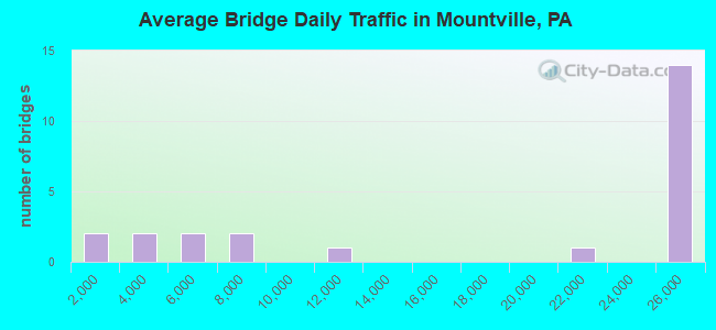
- 405,515Total average daily traffic
- 54,683Total average daily truck traffic
- National Bridge Inventory (NBI) Registered Bridges for Mountville
- No street view available for this location
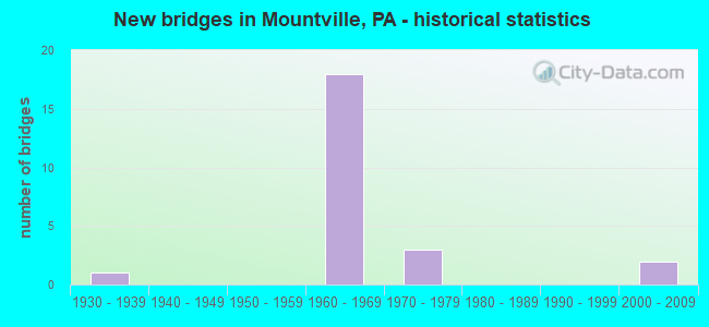
- New bridges - historical statistics
- 11930-1939
- 181960-1969
- 31970-1979
- 22000-2009
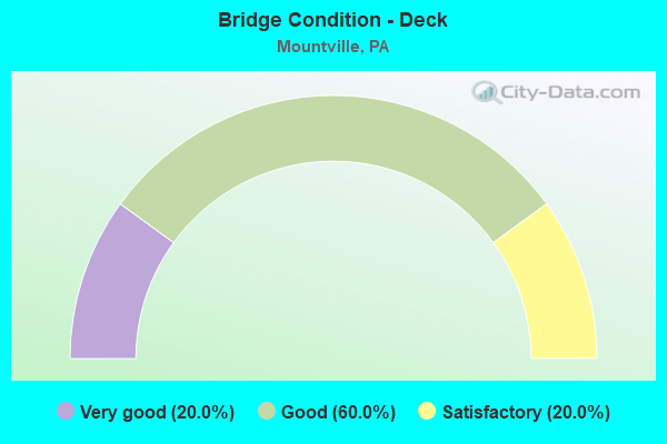
- Bridge Condition - Deck
- 20.0%Very good
- 60.0%Good
- 20.0%Satisfactory
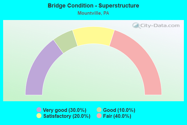
- Bridge Condition - Superstructure
- 30.0%Very good
- 10.0%Good
- 20.0%Satisfactory
- 40.0%Fair
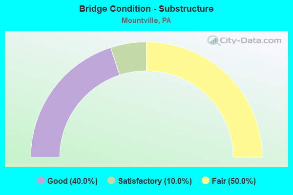
- Bridge Condition - Substructure
- 40.0%Good
- 10.0%Satisfactory
- 50.0%Fair
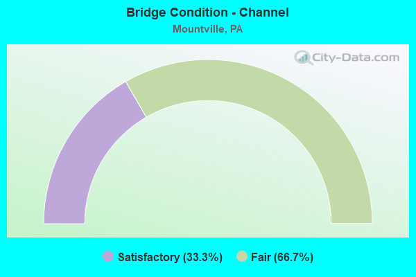
- Bridge Condition - Channel
- 33.3%Satisfactory
- 66.7%Fair
Find on map >> Show street view
Structure Number: 21007, Location: N. OF MOUNTVILLE BORO. (Lat: 40.040214, Lng: -76.447142), Route carried "on" structure: State highway , Year Built: 1965, Status: Open, Structure Length: 4.72m (15.49ft), Average Daily Traffic: 2,041 (year 2022), Truck Traffic: 2%, Average Future Daily Traffic: 2,383 (year 2032), Design Load: HS 20, Features Intersected: US 30; SR 0030, Facility Carried by Structure: SR 4051
Minimum Vertical Clearance: 30+ m (98+ ft), Kilometerpoint: 0.000, Lanes on structure: 2, Lanes under structure: 8, Owner: State Highway Agency, Approaching Roadway Width: 3.7m (12.1ft), Material/Design: Prestressed concrete, Design/Construction: Box Beam or Girders - Multiple, Number Of Spans In Main Unit: 3, Length of Maximum Span: 27.4m (89.9ft), Curb or Sidewalk Widths: Left: 0.5m (1.6ft), Right: 0.5m (1.6ft), Curb-To-Curb Width: 8.5m (27.9ft), Out-to-Out Width: 10.2m (33.5ft)
Condition: Deck: Good, Superstructure: Satisfactory, Substructure: Fair, Operating Rating: 49.0 metric tons, Method Used To Determine Operating Rating: Load Factor (LF), Inventory Rating: 29.0 metric tons, Method Used To Determine Inventory Rating: Load Factor (LF), Structural Evaluation: Somewhat better than minimum adequacy, Deck Geometry: Meets minimum limits, Underclear: High priority of corrective action, Approach Roadway Alignment: Equal to present desirable criteria, Length Of Structure Improvement: 5.60m (18.37ft), Designated Inspection Frequency: Every 24 months, Inspection Date: October 2020, Bridge Improvement Cost: $43,000, Roadway Improvement Cost: $128,000, Total Project Cost: $585,000, Deck Structure Type: Concrete Cast-file-Place, Wearing Surface/Protective System: Wearing Surface: Latex Concrete
Find on map >> Show street view
Structure Number: 21009, Location: N. OF MOUNTVILLE BORO. (Lat: 40.044319, Lng: -76.428942), Route carried "on" structure: State highway , Year Built: 1965, Status: Open, Structure Length: 4.60m (15.09ft), Average Daily Traffic: 2,235 (year 2022), Truck Traffic: 1%, Average Future Daily Traffic: 3,735 (year 2032), Design Load: HS 20, Features Intersected: US 30; SR 0030, Facility Carried by Structure: SR 4053/Druid Hill
Minimum Vertical Clearance: 30+ m (98+ ft), Kilometerpoint: 0.000, Lanes on structure: 2, Lanes under structure: 8, Owner: State Highway Agency, Approaching Roadway Width: 7.3m (24.0ft), Skew: 1 degrees, Material/Design: Prestressed concrete, Design/Construction: Box Beam or Girders - Multiple, Number Of Spans In Main Unit: 1, Number Of Approach Spans: 2, Length of Maximum Span: 27.7m (90.9ft), Curb or Sidewalk Widths: Left: 0.5m (1.6ft), Right: 0.5m (1.6ft), Curb-To-Curb Width: 8.5m (27.9ft), Out-to-Out Width: 10.2m (33.5ft)
Condition: Deck: Good, Superstructure: Good, Substructure: Satisfactory, Operating Rating: 43.5 metric tons, Method Used To Determine Operating Rating: Load Factor (LF), Inventory Rating: 20.0 metric tons, Method Used To Determine Inventory Rating: Load Factor (LF), Structural Evaluation: Somewhat better than minimum adequacy, Deck Geometry: Meets minimum limits, Underclear: High priority of corrective action, Approach Roadway Alignment: Equal to present desirable criteria, Length Of Structure Improvement: 5.50m (18.04ft), Designated Inspection Frequency: Every 24 months, Inspection Date: October 2020, Bridge Improvement Cost: $8,000, Roadway Improvement Cost: $24,000, Total Project Cost: $110,000, Deck Structure Type: Concrete Cast-file-Place, Wearing Surface/Protective System: Wearing Surface: Latex Concrete
Find on map >> Show street view
Structure Number: 2101, Location: 1 MI.N. OF KREADYVILLE (Lat: 40.047331, Lng: -76.411647), Route carried "on" structure: State highway , Year Built: 1964, Status: Open, Structure Length: 2.87m (9.42ft), Average Daily Traffic: 5,488 (year 2022), Truck Traffic: 3%, Average Future Daily Traffic: 7,250 (year 2032), Design Load: HS 20, Features Intersected: US 30; SR 0030, Facility Carried by Structure: SR 4055/N.DONNERVL
Minimum Vertical Clearance: 30.18m (99.02ft), Kilometerpoint: 0.000, Lanes on structure: 2, Lanes under structure: 8, Owner: State Highway Agency, Approaching Roadway Width: 10.4m (34.1ft), Material/Design: Prestressed concrete, Design/Construction: Stringer/Multi-beam, Number Of Spans In Main Unit: 1, Length of Maximum Span: 27.4m (89.9ft), Curb or Sidewalk Widths: Left: 0.5m (1.6ft), Right: 0.5m (1.6ft), Curb-To-Curb Width: 9.1m (29.9ft), Out-to-Out Width: 10.8m (35.4ft)
Condition: Deck: Very good, Superstructure: Fair, Substructure: Good, Operating Rating: 46.3 metric tons, Method Used To Determine Operating Rating: Load Factor (LF), Inventory Rating: 15.4 metric tons, Method Used To Determine Inventory Rating: Load Factor (LF), Structural Evaluation: High priority of corrective action, Deck Geometry: High priority of corrective action, Underclear: High priority of corrective action, Approach Roadway Alignment: Better than present minimum criteria, Length Of Structure Improvement: 3.60m (11.81ft), Designated Inspection Frequency: Every 24 months, Inspection Date: December 2020, Bridge Improvement Cost: $9,000, Roadway Improvement Cost: $27,000, Total Project Cost: $124,000, Deck Structure Type: Concrete Cast-file-Place, Wearing Surface/Protective System: Wearing Surface: Latex Concrete
Find on map >> Show street view
Structure Number: 21011, Location: 0.75 mi.S. of Centerville (Lat: 40.052081, Lng: -76.396142), Route carried "on" structure: State highway , Year Built: 1965, Status: Open, Structure Length: 5.06m (16.60ft), Average Daily Traffic: 21,441 (year 2022), Truck Traffic: 5%, Average Future Daily Traffic: 30,483 (year 2032), Design Load: HS 20, Features Intersected: US 30, Facility Carried by Structure: T-408 Centerville
Minimum Vertical Clearance: 30.45m (99.90ft), Kilometerpoint: 0.000, Lanes on structure: 2, Lanes under structure: 9, Owner: State Highway Agency, Approaching Roadway Width: 10.4m (34.1ft), Material/Design: Prestressed concrete, Design/Construction: Box Beam or Girders - Single/Spread, Number Of Spans In Main Unit: 4, Length of Maximum Span: 17.4m (57.1ft), Curb or Sidewalk Widths: Left: 0.5m (1.6ft), Right: 0.5m (1.6ft), Curb-To-Curb Width: 9.8m (32.2ft), Out-to-Out Width: 11.4m (37.4ft)
Condition: Deck: Satisfactory, Superstructure: Fair, Substructure: Fair, Operating Rating: 53.5 metric tons, Method Used To Determine Operating Rating: Load Factor (LF), Inventory Rating: 31.8 metric tons, Method Used To Determine Inventory Rating: Load Factor (LF), Structural Evaluation: Somewhat better than minimum adequacy, Deck Geometry: Meets minimum limits, Underclear: High priority of corrective action, Approach Roadway Alignment: Equal to present desirable criteria, Length Of Structure Improvement: 6.00m (19.69ft), Designated Inspection Frequency: Every 24 months, Inspection Date: October 2020, Bridge Improvement Cost: $94,000, Roadway Improvement Cost: $278,000, Total Project Cost: $1,272,000, Deck Structure Type: Concrete Cast-file-Place, Wearing Surface/Protective System: Wearing Surface: Bituminous, Membrane: Preformed Fabric
Find on map >> Show street view
Structure Number: 21275, Location: MOUNTVILLE BOROUGH (Lat: 40.038297, Lng: -76.424997), Route carried "on" structure: State highway 462, Year Built: 1930, Year Reconstructed: 2011, Status: Open, Structure Length: 3.23m (10.60ft), Average Daily Traffic: 10,027 (year 2022), Truck Traffic: 6%, Average Future Daily Traffic: 14,861 (year 2032), Design Load: H 15, Features Intersected: Norfolk Southern RR
Minimum Vertical Clearance: 30+ m (98+ ft), Kilometerpoint: 8.509, Lanes on structure: 2, Owner: State Highway Agency, Approaching Roadway Width: 10.4m (34.1ft), Skew: 6 degrees, Material/Design: Steel, Design/Construction: Stringer/Multi-beam, Number Of Spans In Main Unit: 1, Length of Maximum Span: 27.7m (90.9ft), Curb or Sidewalk Widths: Left: 1.6m (5.2ft), Right: 1.6m (5.2ft), Curb-To-Curb Width: 11.0m (36.1ft), Out-to-Out Width: 14.7m (48.2ft)
Condition: Deck: Good, Superstructure: Very good, Substructure: Fair, Operating Rating: 83.5 metric tons, Method Used To Determine Operating Rating: Load Factor (LF), Inventory Rating: 49.9 metric tons, Method Used To Determine Inventory Rating: Load Factor (LF), Structural Evaluation: Somewhat better than minimum adequacy, Deck Geometry: Meets minimum limits, Underclear: High priority of replacement, Approach Roadway Alignment: Equal to present desirable criteria, Length Of Structure Improvement: 3.40m (11.15ft), Designated Inspection Frequency: Every 24 months, Inspection Date: April 2020, Bridge Improvement Cost: $130,000, Roadway Improvement Cost: $384,000, Total Project Cost: $1,758,000, Deck Structure Type: Concrete Cast-file-Place, Wearing Surface/Protective System: Wearing Surface: Monolithic Concrete, Deck Protection: Epoxy Coated Reinforcing
Find on map >> Show street view
Structure Number: 21366, Location: 2 MI.W. OF MILLERSVILLE (Lat: 40.007308, Lng: -76.401989), Route carried "on" structure: State highway 999, Year Built: 1964, Status: Open, Structure Length: 0.85m (2.79ft), Average Daily Traffic: 5,786 (year 2022), Truck Traffic: 4%, Average Future Daily Traffic: 7,028 (year 2032), Design Load: HS 20, Features Intersected: W BR L CONESTOGA CREEK
Minimum Vertical Clearance: 30+ m (98+ ft), Kilometerpoint: 6.177, Lanes on structure: 2, Base Highway Network: Yes, Owner: State Highway Agency, Approaching Roadway Width: 10.7m (35.1ft), Skew: 1 degrees, Material/Design: Concrete, Design/Construction: Slab, Number Of Spans In Main Unit: 1, Length of Maximum Span: 7.9m (25.9ft), Curb or Sidewalk Widths: Left: 0.5m (1.6ft), Right: 0.5m (1.6ft), Curb-To-Curb Width: 11.6m (38.1ft), Out-to-Out Width: 13.3m (43.6ft)
Condition: Deck: Satisfactory, Superstructure: Satisfactory, Substructure: Good, Channel: Satisfactory, Operating Rating: 59.0 metric tons, Method Used To Determine Operating Rating: Load Factor (LF), Inventory Rating: 35.4 metric tons, Method Used To Determine Inventory Rating: Load Factor (LF), Structural Evaluation: Equal to present minimum criteria, Deck Geometry: Somewhat better than minimum adequacy, Waterway Adequacy: Equal to present minimum criteria, Approach Roadway Alignment: Equal to present desirable criteria, Length Of Structure Improvement: 1.50m (4.92ft), Designated Inspection Frequency: Every 24 months, Inspection Date: June 2020, Wearing Surface/Protective System: Wearing Surface: Bituminous
Find on map >> Show street view
Structure Number: 21638, Location: N.SIDE OF MOUNTVILLE (Lat: 40.045592, Lng: -76.422294), Route carried "on" structure: State highway , Year Built: 1965, Status: Open, Structure Length: 4.63m (15.19ft), Average Daily Traffic: 6,435 (year 2021), Truck Traffic: 5%, Average Future Daily Traffic: 12,151 (year 2032), Design Load: HS 20, Features Intersected: US 30; SR 0030, Facility Carried by Structure: S.STONY BATTERY RD
Minimum Vertical Clearance: 30+ m (98+ ft), Kilometerpoint: 24.610, Lanes on structure: 2, Lanes under structure: 8, Owner: State Highway Agency, Approaching Roadway Width: 13.1m (43.0ft), Skew: 1 degrees, Material/Design: Prestressed concrete, Design/Construction: Box Beam or Girders - Multiple, Number Of Spans In Main Unit: 1, Number Of Approach Spans: 2, Length of Maximum Span: 28.0m (91.9ft), Curb or Sidewalk Widths: Left: 0.5m (1.6ft), Right: 0.5m (1.6ft), Curb-To-Curb Width: 12.2m (40.0ft), Out-to-Out Width: 13.9m (45.6ft)
Condition: Deck: Good, Superstructure: Fair, Substructure: Fair, Operating Rating: 71.7 metric tons, Method Used To Determine Operating Rating: Load Factor (LF), Inventory Rating: 20.9 metric tons, Method Used To Determine Inventory Rating: Load Factor (LF), Structural Evaluation: Somewhat better than minimum adequacy, Deck Geometry: Somewhat better than minimum adequacy, Underclear: High priority of corrective action, Approach Roadway Alignment: Equal to present desirable criteria, Length Of Structure Improvement: 5.50m (18.04ft), Designated Inspection Frequency: Every 24 months, Inspection Date: October 2020, Bridge Improvement Cost: $36,000, Roadway Improvement Cost: $106,000, Total Project Cost: $485,000, Deck Structure Type: Concrete Cast-file-Place, Wearing Surface/Protective System: Wearing Surface: Monolithic Concrete
Find on map >> Show street view
Structure Number: 21688, Location: N OF MOUNTVILLE BORO (Lat: 40.038917, Lng: -76.455281), Route carried "on" structure: State highway , Year Built: 1970, Status: Open, Structure Length: 6.74m (22.11ft), Average Daily Traffic: 6,245 (year 2020), Truck Traffic: 7%, Average Future Daily Traffic: 8,167 (year 2032), Design Load: HS 20, Features Intersected: US 30; SR 0030, Facility Carried by Structure: 4005 Prospect Rd
Minimum Vertical Clearance: 30+ m (98+ ft), Kilometerpoint: 0.000, Lanes on structure: 2, Lanes under structure: 8, Owner: State Highway Agency, Approaching Roadway Width: 14.0m (45.9ft), Skew: 1 degrees, Material/Design: Steel, Design/Construction: Stringer/Multi-beam, Number Of Spans In Main Unit: 1, Number Of Approach Spans: 2, Length of Maximum Span: 40.8m (133.9ft), Curb or Sidewalk Widths: Left: 0.2m (0.7ft), Right: 0.2m (0.7ft), Curb-To-Curb Width: 13.4m (44.0ft), Out-to-Out Width: 14.6m (47.9ft)
Condition: Deck: Good, Superstructure: Fair, Substructure: Fair, Operating Rating: 58.1 metric tons, Method Used To Determine Operating Rating: Load Factor (LF), Inventory Rating: 34.5 metric tons, Method Used To Determine Inventory Rating: Load Factor (LF), Structural Evaluation: Somewhat better than minimum adequacy, Deck Geometry: Equal to present minimum criteria, Underclear: High priority of corrective action, Approach Roadway Alignment: Equal to present desirable criteria, Length Of Structure Improvement: 7.70m (25.26ft), Designated Inspection Frequency: Every 24 months, Inspection Date: October 2020, Bridge Improvement Cost: $36,000, Roadway Improvement Cost: $107,000, Total Project Cost: $488,000, Deck Structure Type: Concrete Cast-file-Place, Wearing Surface/Protective System: Wearing Surface: Latex Concrete
Find on map >> Show street view
Structure Number: 21982, Location: 0.6 MI WEST OF SR 3031 (Lat: 40.014472, Lng: -76.406133), Route carried "on" structure: City street 5, Year Built: 2000, Status: Open, Structure Length: 0.82m (2.69ft), Average Daily Traffic: 415 (year 2011), Truck Traffic: 1%, Average Future Daily Traffic: 550 (year 2031), Design Load: H 20, Features Intersected: W BR LITTLE CONESTOGA CR
Minimum Vertical Clearance: 30+ m (98+ ft), Kilometerpoint: 0.000, Lanes on structure: 2, Owner: Town or Township Highway Agency, Approaching Roadway Width: 7.3m (24.0ft), Skew: 2 degrees, Material/Design: Prestressed concrete, Design/Construction: Slab, Number Of Spans In Main Unit: 1, Length of Maximum Span: 7.6m (24.9ft), Curb or Sidewalk Widths: Left: 0.2m (0.7ft), Right: 0.2m (0.7ft), Curb-To-Curb Width: 7.3m (24.0ft), Out-to-Out Width: 8.2m (26.9ft)
Condition: Deck: Very good, Superstructure: Very good, Substructure: Good, Channel: Fair, Inventory Rating: 63.5 metric tons, Method Used To Determine Inventory Rating: Load Factor (LF), Structural Evaluation: Better than present minimum criteria, Deck Geometry: Meets minimum limits, Waterway Adequacy: Better than present minimum criteria, Approach Roadway Alignment: Equal to present desirable criteria, Length Of Structure Improvement: 0.70m (2.30ft), Designated Inspection Frequency: Every 24 months, Inspection Date: October 2019, Bridge Improvement Cost: $2,000, Roadway Improvement Cost: $11,000, Total Project Cost: $27,000, Deck Structure Type: Concrete Cast-file-Place, Wearing Surface/Protective System: Wearing Surface: Monolithic Concrete, Deck Protection: Epoxy Coated Reinforcing
Find on map >> Show street view
Structure Number: 21983, Location: 1/2 MI SW OF SR 3031 (Lat: 40.021419, Lng: -76.408342), Route carried "on" structure: City street , Year Built: 2000, Status: Open, Structure Length: 0.79m (2.59ft), Average Daily Traffic: 260 (year 2011), Truck Traffic: 10%, Average Future Daily Traffic: 350 (year 2031), Design Load: H 20, Features Intersected: W BR LITTLE CONESTOGA CR, Facility Carried by Structure: HABECKER CHURCH RD
Minimum Vertical Clearance: 30+ m (98+ ft), Kilometerpoint: 0.000, Lanes on structure: 2, Owner: Town or Township Highway Agency, Approaching Roadway Width: 7.3m (24.0ft), Skew: 2 degrees, Material/Design: Prestressed concrete, Design/Construction: Slab, Number Of Spans In Main Unit: 1, Length of Maximum Span: 7.6m (24.9ft), Curb or Sidewalk Widths: Left: 0.2m (0.7ft), Right: 0.2m (0.7ft), Curb-To-Curb Width: 7.3m (24.0ft), Out-to-Out Width: 8.2m (26.9ft)
Condition: Deck: Good, Superstructure: Very good, Substructure: Good, Channel: Fair, Operating Rating: 84.4 metric tons, Method Used To Determine Operating Rating: Load Factor (LF), Inventory Rating: 31.8 metric tons, Method Used To Determine Inventory Rating: Load Factor (LF), Structural Evaluation: Better than present minimum criteria, Deck Geometry: Somewhat better than minimum adequacy, Waterway Adequacy: Better than present minimum criteria, Approach Roadway Alignment: Equal to present desirable criteria, Length Of Structure Improvement: 1.40m (4.59ft), Designated Inspection Frequency: Every 24 months, Inspection Date: October 2019, Deck Structure Type: Concrete Cast-file-Place, Wearing Surface/Protective System: Wearing Surface: Monolithic Concrete, Deck Protection: Epoxy Coated Reinforcing
Find on map >> Show street view
Structure Number: 21007, Location: N. OF MOUNTVILLE BORO. (Lat: 40.040214, Lng: -76.447142), Route carried "under" structure: US 30, Year Built: 1965, Structure Length: 0. m, Average Daily Traffic: 25,016 (year 2020), Truck Traffic: 15%, Features Intersected: US 30; SR 0030, Facility Carried by Structure: SR 4051
Minimum Vertical Clearance: 4.47m (14.67ft), Kilometerpoint: 7.640, Lanes on structure: 2, Lanes under structure: 4, Material/Design: Prestressed concrete, Design/Construction: Box Beam or Girders - Multiple, Length of Maximum Span: 27.4m (89.9ft)
Find on map >> Show street view
Structure Number: 21007, Location: N. OF MOUNTVILLE BORO. (Lat: 40.040214, Lng: -76.447142), Route carried "under" structure: US 30, Year Built: 1965, Structure Length: 0. m, Average Daily Traffic: 24,290 (year 2020), Truck Traffic: 15%, Features Intersected: US 30; SR 0030, Facility Carried by Structure: SR 4051
Minimum Vertical Clearance: 5.18m (16.99ft), Kilometerpoint: 7.649, Lanes on structure: 2, Lanes under structure: 4, Material/Design: Prestressed concrete, Design/Construction: Box Beam or Girders - Multiple, Length of Maximum Span: 27.4m (89.9ft)
Find on map >> Show street view
Structure Number: 21009, Location: N. OF MOUNTVILLE BORO. (Lat: 40.044319, Lng: -76.428942), Route carried "under" structure: US 30, Year Built: 1965, Structure Length: 0. m, Average Daily Traffic: 25,016 (year 2020), Truck Traffic: 15%, Features Intersected: US 30; SR 0030, Facility Carried by Structure: SR 4053/Druid Hill
Minimum Vertical Clearance: 4.55m (14.93ft), Kilometerpoint: 9.262, Lanes on structure: 2, Lanes under structure: 4, Material/Design: Prestressed concrete, Design/Construction: Box Beam or Girders - Multiple, Length of Maximum Span: 27.7m (90.9ft)
Find on map >> Show street view
Structure Number: 21009, Location: N. OF MOUNTVILLE BORO. (Lat: 40.044319, Lng: -76.428942), Route carried "under" structure: US 30, Year Built: 1965, Structure Length: 0. m, Average Daily Traffic: 24,290 (year 2020), Truck Traffic: 15%, Features Intersected: US 30; SR 0030, Facility Carried by Structure: SR 4053/Druid Hill
Minimum Vertical Clearance: 4.55m (14.93ft), Kilometerpoint: 9.265, Lanes on structure: 2, Lanes under structure: 4, Material/Design: Prestressed concrete, Design/Construction: Box Beam or Girders - Multiple, Length of Maximum Span: 27.7m (90.9ft)
Find on map >> Show street view
Structure Number: 2101, Location: 1 MI.N. OF KREADYVILLE (Lat: 40.047331, Lng: -76.411647), Route carried "under" structure: US 30, Year Built: 1964, Structure Length: 0. m, Average Daily Traffic: 25,016 (year 2020), Truck Traffic: 15%, Features Intersected: US 30; SR 0030, Facility Carried by Structure: SR 4055/N.DONNERVL
Minimum Vertical Clearance: 4.42m (14.50ft), Kilometerpoint: 10.784, Lanes on structure: 2, Lanes under structure: 4, Material/Design: Prestressed concrete, Design/Construction: Stringer/Multi-beam, Length of Maximum Span: 27.4m (89.9ft)
Find on map >> Show street view
Structure Number: 2101, Location: 1 MI.N. OF KREADYVILLE (Lat: 40.047331, Lng: -76.411647), Route carried "under" structure: US 30, Year Built: 1964, Structure Length: 0. m, Average Daily Traffic: 24,290 (year 2020), Truck Traffic: 15%, Features Intersected: US 30; SR 0030, Facility Carried by Structure: SR 4055/N.DONNERVL
Minimum Vertical Clearance: 4.82m (15.81ft), Kilometerpoint: 10.786, Lanes on structure: 2, Lanes under structure: 4, Material/Design: Prestressed concrete, Design/Construction: Stringer/Multi-beam, Length of Maximum Span: 27.4m (89.9ft)
Find on map >> Show street view
Structure Number: 21011, Location: 0.75 mi.S. of Centerville (Lat: 40.052081, Lng: -76.396142), Route carried "under" structure: US 30, Year Built: 1965, Structure Length: 0. m, Average Daily Traffic: 25,016 (year 2020), Truck Traffic: 15%, Features Intersected: US 30, Facility Carried by Structure: T-408 Centerville
Minimum Vertical Clearance: 4.47m (14.67ft), Kilometerpoint: 12.149, Lanes on structure: 2, Lanes under structure: 5, Material/Design: Prestressed concrete, Design/Construction: Box Beam or Girders - Single/Spread, Length of Maximum Span: 17.4m (57.1ft)
Find on map >> Show street view
Structure Number: 21011, Location: 0.75 mi.S. of Centerville (Lat: 40.052081, Lng: -76.396142), Route carried "under" structure: US 30, Year Built: 1965, Structure Length: 0. m, Average Daily Traffic: 24,290 (year 2020), Truck Traffic: 15%, Features Intersected: US 30, Facility Carried by Structure: T-408 Centerville
Minimum Vertical Clearance: 5.23m (17.16ft), Kilometerpoint: 12.138, Lanes on structure: 2, Lanes under structure: 4, Material/Design: Prestressed concrete, Design/Construction: Box Beam or Girders - Single/Spread, Length of Maximum Span: 17.4m (57.1ft)
Find on map >> Show street view
Structure Number: 21638, Location: N.SIDE OF MOUNTVILLE (Lat: 40.045592, Lng: -76.422294), Route carried "under" structure: US 30, Year Built: 1965, Structure Length: 0. m, Average Daily Traffic: 25,016 (year 2020), Truck Traffic: 15%, Features Intersected: US 30; SR 0030, Facility Carried by Structure: S.STONY BATTERY RD
Minimum Vertical Clearance: 4.45m (14.60ft), Kilometerpoint: 9.846, Lanes on structure: 2, Lanes under structure: 4, Material/Design: Prestressed concrete, Design/Construction: Box Beam or Girders - Multiple, Length of Maximum Span: 28.0m (91.9ft)
Find on map >> Show street view
Structure Number: 21638, Location: N.SIDE OF MOUNTVILLE (Lat: 40.045592, Lng: -76.422294), Route carried "under" structure: US 30, Year Built: 1965, Structure Length: 0. m, Average Daily Traffic: 24,290 (year 2020), Truck Traffic: 15%, Features Intersected: US 30; SR 0030, Facility Carried by Structure: S.STONY BATTERY RD
Minimum Vertical Clearance: 4.57m (14.99ft), Kilometerpoint: 9.857, Lanes on structure: 2, Lanes under structure: 4, Material/Design: Prestressed concrete, Design/Construction: Box Beam or Girders - Multiple, Length of Maximum Span: 28.0m (91.9ft)
Find on map >> Show street view
Structure Number: 21688, Location: N OF MOUNTVILLE BORO (Lat: 40.038917, Lng: -76.455281), Route carried "under" structure: US 30, Year Built: 1970, Structure Length: 0. m, Average Daily Traffic: 25,016 (year 2020), Truck Traffic: 15%, Features Intersected: US 30; SR 0030, Facility Carried by Structure: 4005 Prospect Rd
Minimum Vertical Clearance: 4.57m (14.99ft), Kilometerpoint: 6.526, Lanes on structure: 2, Lanes under structure: 4, Material/Design: Steel, Design/Construction: Stringer/Multi-beam, Length of Maximum Span: 40.8m (133.9ft)
Find on map >> Show street view
Structure Number: 21688, Location: N OF MOUNTVILLE BORO (Lat: 40.038917, Lng: -76.455281), Route carried "under" structure: US 30, Year Built: 1970, Structure Length: 0. m, Average Daily Traffic: 24,290 (year 2020), Truck Traffic: 15%, Features Intersected: US 30; SR 0030, Facility Carried by Structure: 4005 Prospect Rd
Minimum Vertical Clearance: 5.11m (16.77ft), Kilometerpoint: 6.532, Lanes on structure: 2, Lanes under structure: 4, Material/Design: Steel, Design/Construction: Stringer/Multi-beam, Length of Maximum Span: 40.8m (133.9ft)
Find on map >> Show street view
Structure Number: 2169, Location: N OF MOUNTVILLE BORO (Lat: 40.042122, Lng: -76.436800), Route carried "under" structure: US 30, Year Built: 1965, Structure Length: 0. m, Average Daily Traffic: 25,016 (year 2020), Truck Traffic: 15%, Features Intersected: US 30; SR 0030, Facility Carried by Structure: SR 4007,HILL ST
Minimum Vertical Clearance: 4.39m (14.40ft), Kilometerpoint: 8.552, Lanes on structure: 2, Lanes under structure: 4, Material/Design: Prestressed concrete, Design/Construction: Stringer/Multi-beam, Length of Maximum Span: 29.3m (96.1ft)
Find on map >> Show street view
Structure Number: 2169, Location: N OF MOUNTVILLE BORO (Lat: 40.042122, Lng: -76.436800), Route carried "under" structure: US 30, Year Built: 1965, Structure Length: 0. m, Average Daily Traffic: 24,290 (year 2020), Truck Traffic: 15%, Features Intersected: US 30; SR 0030, Facility Carried by Structure: SR 4007,HILL ST
Minimum Vertical Clearance: 4.42m (14.50ft), Kilometerpoint: 8.550, Lanes on structure: 2, Lanes under structure: 4, Material/Design: Prestressed concrete, Design/Construction: Stringer/Multi-beam, Length of Maximum Span: 29.3m (96.1ft)