Bridge Statistics for Myersville, Maryland (MD)
Condition, Traffic, Stress, Structural Evaluation, Project Costs
- National Bridge Inventory (NBI) Statistics
- 45Number of bridges
- 371ft / 113mTotal length
- $290,000Total costs
- 753,225Total average daily traffic
- 54,491Total average daily truck traffic
- National Bridge Inventory (NBI) Registered Bridges for Myersville
- No street view available for this location
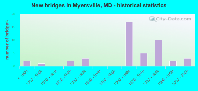
- New bridges - historical statistics
- 2Before 1900
- 11900-1909
- 21920-1929
- 31930-1939
- 171960-1969
- 51970-1979
- 101980-1989
- 21990-1999
- 32000-2009
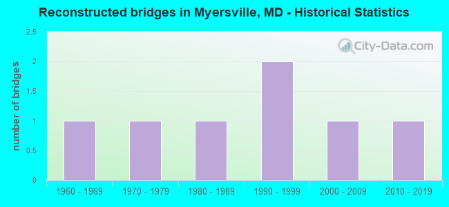
- Reconstructed bridges - Historical Statistics
- 11960-1969
- 11970-1979
- 11980-1989
- 21990-1999
- 12000-2009
- 12010-2019
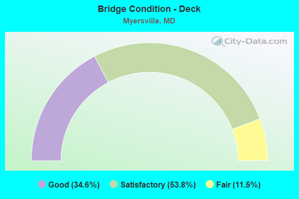
- Bridge Condition - Deck
- 34.6%Good
- 53.8%Satisfactory
- 11.5%Fair
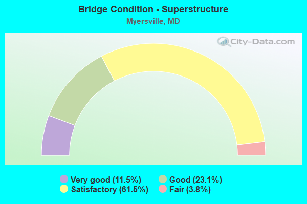
- Bridge Condition - Superstructure
- 11.5%Very good
- 23.1%Good
- 61.5%Satisfactory
- 3.8%Fair
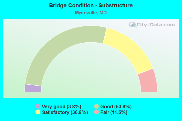
- Bridge Condition - Substructure
- 3.8%Very good
- 53.8%Good
- 30.8%Satisfactory
- 11.5%Fair
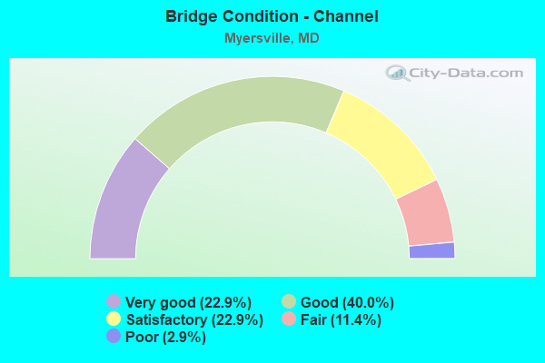
- Bridge Condition - Channel
- 22.9%Very good
- 40.0%Good
- 22.9%Satisfactory
- 11.4%Fair
- 2.9%Poor
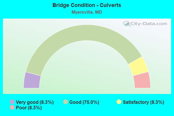
- Bridge Condition - Culverts
- 8.3%Very good
- 75.0%Good
- 8.3%Satisfactory
- 8.3%Poor
Find on map >> Show street view
Structure Number: 10000010003001, Location: 0.17 MILE WEST OF MD 17 (Lat: 39.511444, Lng: -77.562022), Route carried "on" structure: US 40, Year Built: 1936, Status: Open, Structure Length: 1.52m (4.99ft), Average Daily Traffic: 5,432 (year 2009), Truck Traffic: 8%, Average Future Daily Traffic: 6,678 (year 2026), Design Load: H 20, Features Intersected: CATOCTIN CREEK
Minimum Vertical Clearance: 30+ m (98+ ft), Kilometerpoint: 4.730, Lanes on structure: 2, Owner: State Highway Agency, Approaching Roadway Width: 12.2m (40.0ft), Skew: 3 degrees, Material/Design: Concrete, Design/Construction: Arch - Deck, Number Of Spans In Main Unit: 1, Length of Maximum Span: 15.2m (49.9ft), Curb-To-Curb Width: 12.2m (40.0ft), Out-to-Out Width: 13.6m (44.6ft)
Condition: Deck: Satisfactory, Superstructure: Satisfactory, Substructure: Fair, Channel: Poor, Operating Rating: 50.3 metric tons, Method Used To Determine Operating Rating: Load Factor (LF), Inventory Rating: 29.9 metric tons, Method Used To Determine Inventory Rating: Load Factor (LF), Structural Evaluation: Somewhat better than minimum adequacy, Deck Geometry: Somewhat better than minimum adequacy, Waterway Adequacy: Superior to present desirable criteria, Approach Roadway Alignment: Equal to present desirable criteria, Designated Inspection Frequency: Every 24 months, Inspection Date: July 2020, Deck Structure Type: Concrete Cast-file-Place, Wearing Surface/Protective System: Wearing Surface: Bituminous
Find on map >> Show street view
Structure Number: 10000010003101, Location: 0.12 MILE EAST OF MD 17 (Lat: 39.508492, Lng: -77.557506), Route carried "on" structure: US 40, Year Built: 1936, Status: Open, Structure Length: 3.71m (12.17ft), Average Daily Traffic: 5,522 (year 2009), Truck Traffic: 8%, Average Future Daily Traffic: 6,678 (year 2026), Design Load: H 20, Features Intersected: MIDDLE CREEK
Minimum Vertical Clearance: 30+ m (98+ ft), Kilometerpoint: 5.197, Lanes on structure: 2, Owner: State Highway Agency, Approaching Roadway Width: 12.2m (40.0ft), Skew: 3 degrees, Material/Design: Concrete, Design/Construction: Arch - Deck, Number Of Spans In Main Unit: 2, Length of Maximum Span: 17.7m (58.1ft), Curb-To-Curb Width: 12.2m (40.0ft), Out-to-Out Width: 13.6m (44.6ft)
Condition: Deck: Satisfactory, Superstructure: Satisfactory, Substructure: Satisfactory, Channel: Fair, Operating Rating: 54.4 metric tons, Method Used To Determine Operating Rating: Load Factor (LF), Inventory Rating: 32.7 metric tons, Method Used To Determine Inventory Rating: Load Factor (LF), Structural Evaluation: Equal to present minimum criteria, Deck Geometry: Somewhat better than minimum adequacy, Waterway Adequacy: Better than present minimum criteria, Approach Roadway Alignment: Equal to present desirable criteria, Designated Inspection Frequency: Every 24 months, Inspection Date: October 2020, Deck Structure Type: Concrete Cast-file-Place, Wearing Surface/Protective System: Wearing Surface: Bituminous
Find on map >> Show street view
Structure Number: 10000010003201, Location: 0.2 M E OF HARMONY ROAD (Lat: 39.489064, Lng: -77.533258), Route carried "on" structure: US 40, Year Built: 1936, Status: Open, Structure Length: 1.16m (3.81ft), Average Daily Traffic: 5,522 (year 2009), Truck Traffic: 8%, Average Future Daily Traffic: 6,678 (year 2026), Design Load: H 20, Features Intersected: LITTLE CATOCTIN CREEK
Minimum Vertical Clearance: 30+ m (98+ ft), Kilometerpoint: 8.238, Lanes on structure: 2, Owner: State Highway Agency, Approaching Roadway Width: 12.2m (40.0ft), Skew: 2 degrees, Material/Design: Concrete, Design/Construction: Arch - Deck, Number Of Spans In Main Unit: 1, Length of Maximum Span: 11.6m (38.1ft), Curb-To-Curb Width: 12.2m (40.0ft), Out-to-Out Width: 13.6m (44.6ft)
Condition: Deck: Satisfactory, Superstructure: Satisfactory, Substructure: Satisfactory, Channel: Fair, Inventory Rating: 68.9 metric tons, Method Used To Determine Inventory Rating: Load Factor (LF), Structural Evaluation: Equal to present minimum criteria, Deck Geometry: Somewhat better than minimum adequacy, Waterway Adequacy: Superior to present desirable criteria, Approach Roadway Alignment: Equal to present desirable criteria, Designated Inspection Frequency: Every 24 months, Inspection Date: May 2020, Deck Structure Type: Concrete Cast-file-Place, Wearing Surface/Protective System: Wearing Surface: Bituminous
Find on map >> Show street view
Structure Number: 10000010006801, Location: AT MIDDLE POINT ROAD (Lat: 39.562967, Lng: -77.525350), Route carried "on" structure: State highway 17, Year Built: 2005, Status: Open, Structure Length: 0.94m (3.08ft), Average Daily Traffic: 1,951 (year 2009), Truck Traffic: 6%, Average Future Daily Traffic: 3,332 (year 2026), Design Load: HS 25 or greater, Features Intersected: MIDDLE CREEK
Minimum Vertical Clearance: 30+ m (98+ ft), Kilometerpoint: 38.938, Lanes on structure: 2, Owner: State Highway Agency, Approaching Roadway Width: 9.1m (29.9ft), Skew: 3 degrees, Material/Design: Prestressed concrete, Design/Construction: Slab, Number Of Spans In Main Unit: 1, Length of Maximum Span: 8.2m (26.9ft), Curb-To-Curb Width: 9.1m (29.9ft), Out-to-Out Width: 10.1m (33.1ft)
Condition: Deck: Good, Superstructure: Good, Substructure: Good, Channel: Satisfactory, Operating Rating: 80.3 metric tons, Method Used To Determine Operating Rating: Load Factor (LF), Inventory Rating: 48.1 metric tons, Method Used To Determine Inventory Rating: Load Factor (LF), Structural Evaluation: Better than present minimum criteria, Deck Geometry: Somewhat better than minimum adequacy, Waterway Adequacy: Equal to present desirable criteria, Approach Roadway Alignment: Equal to present desirable criteria, Designated Inspection Frequency: Every 24 months, Inspection Date: September 2021, Deck Structure Type: Concrete Precast Panels, Wearing Surface/Protective System: Wearing Surface: Integral Concrete, Deck Protection: Epoxy Coated Reinforcing
Find on map >> Show street view
Structure Number: 10000010006901, Location: 1.55 M N OF CROW ROCK RD (Lat: 39.545961, Lng: -77.526044), Route carried "on" structure: State highway 17, Year Built: 2005, Status: Open, Structure Length: 4.05m (13.29ft), Average Daily Traffic: 1,951 (year 2009), Truck Traffic: 6%, Average Future Daily Traffic: 3,332 (year 2026), Design Load: HS 25 or greater, Features Intersected: MIDDLE CREEK
Minimum Vertical Clearance: 30+ m (98+ ft), Kilometerpoint: 36.975, Lanes on structure: 2, Owner: State Highway Agency, Approaching Roadway Width: 9.1m (29.9ft), Skew: 4 degrees, Material/Design: Prestressed concrete continuous, Design/Construction: Stringer/Multi-beam, Number Of Spans In Main Unit: 2, Length of Maximum Span: 19.2m (63.0ft), Curb-To-Curb Width: 9.1m (29.9ft), Out-to-Out Width: 10.4m (34.1ft)
Condition: Deck: Good, Superstructure: Very good, Substructure: Good, Channel: Very good, Operating Rating: 63.9 metric tons, Method Used To Determine Operating Rating: Load Factor (LF), Inventory Rating: 38.1 metric tons, Method Used To Determine Inventory Rating: Load Factor (LF), Structural Evaluation: Better than present minimum criteria, Deck Geometry: Somewhat better than minimum adequacy, Waterway Adequacy: Equal to present desirable criteria, Approach Roadway Alignment: Equal to present desirable criteria, Designated Inspection Frequency: Every 24 months, Inspection Date: September 2021, Deck Structure Type: Concrete Cast-file-Place, Wearing Surface/Protective System: Wearing Surface: Integral Concrete, Deck Protection: Epoxy Coated Reinforcing
Find on map >> Show street view
Structure Number: 10000010007001, Location: 1.64 MILES N0RTH OF US 40 (Lat: 39.526944, Lng: -77.543314), Route carried "on" structure: State highway 17, Year Built: 1889, Year Reconstructed: 1971, Status: Open, Structure Length: 2.04m (6.69ft), Average Daily Traffic: 1,951 (year 2009), Truck Traffic: 8%, Average Future Daily Traffic: 3,332 (year 2026), Design Load: HS 20, Features Intersected: MIDDLE CREEK
Minimum Vertical Clearance: 30+ m (98+ ft), Kilometerpoint: 33.934, Lanes on structure: 2, Owner: State Highway Agency, Approaching Roadway Width: 10.4m (34.1ft), Material/Design: Concrete, Design/Construction: Slab, Number Of Spans In Main Unit: 3, Length of Maximum Span: 6.7m (22.0ft), Curb or Sidewalk Widths: Left: 0.0m, Right: 0.9m (3.0ft), Curb-To-Curb Width: 9.1m (29.9ft), Out-to-Out Width: 10.9m (35.8ft)
Condition: Deck: Satisfactory, Superstructure: Satisfactory, Substructure: Satisfactory, Channel: Satisfactory, Inventory Rating: 61.2 metric tons, Method Used To Determine Inventory Rating: Load Factor (LF), Structural Evaluation: Equal to present minimum criteria, Deck Geometry: Somewhat better than minimum adequacy, Waterway Adequacy: Equal to present minimum criteria, Approach Roadway Alignment: Equal to present minimum criteria, Designated Inspection Frequency: Every 24 months, Inspection Date: June 2020, Deck Structure Type: Concrete Cast-file-Place, Wearing Surface/Protective System: Wearing Surface: Monolithic Concrete
Find on map >> Show street view
Structure Number: 10000010007101, Location: 0.9 MILE NORTH OF US 40 (Lat: 39.517322, Lng: -77.547675), Route carried "on" structure: State highway 17, Year Built: 2005, Status: Open, Structure Length: 3.38m (11.09ft), Average Daily Traffic: 1,951 (year 2009), Truck Traffic: 6%, Average Future Daily Traffic: 3,332 (year 2026), Design Load: HS 25 or greater, Features Intersected: MIDDLE CREEK
Minimum Vertical Clearance: 30+ m (98+ ft), Kilometerpoint: 32.743, Lanes on structure: 2, Owner: State Highway Agency, Approaching Roadway Width: 9.1m (29.9ft), Skew: 2 degrees, Material/Design: Prestressed concrete, Design/Construction: Stringer/Multi-beam, Number Of Spans In Main Unit: 1, Length of Maximum Span: 31.7m (104.0ft), Curb-To-Curb Width: 9.1m (29.9ft), Out-to-Out Width: 10.6m (34.8ft)
Condition: Deck: Good, Superstructure: Very good, Substructure: Good, Channel: Good, Operating Rating: 79.8 metric tons, Method Used To Determine Operating Rating: Load Factor (LF), Inventory Rating: 47.6 metric tons, Method Used To Determine Inventory Rating: Load Factor (LF), Structural Evaluation: Better than present minimum criteria, Deck Geometry: Somewhat better than minimum adequacy, Waterway Adequacy: Equal to present desirable criteria, Approach Roadway Alignment: Equal to present minimum criteria, Designated Inspection Frequency: Every 24 months, Inspection Date: September 2021, Deck Structure Type: Concrete Cast-file-Place, Wearing Surface/Protective System: Wearing Surface: Integral Concrete, Deck Protection: Epoxy Coated Reinforcing
Find on map >> Show street view
Structure Number: 100000100129013, Location: 1.96 MILES EAST OF MD 17 (Lat: 39.480761, Lng: -77.539428), Route carried "on" structure: Interstate 70, Year Built: 1968, Status: Open, Structure Length: 10.18m (33.40ft), Average Daily Traffic: 68,230 (year 2009), Truck Traffic: 8%, Average Future Daily Traffic: 37,854 (year 2026), Design Load: HS 20+Mod, Features Intersected: HARMONY RD, LITTLE CATOC
Minimum Vertical Clearance: 30+ m (98+ ft), Kilometerpoint: 8.867, Lanes on structure: 2, Lanes under structure: 2, Base Highway Network: Yes, Owner: State Highway Agency, Approaching Roadway Width: 11.6m (38.1ft), Material/Design: Steel continuous, Design/Construction: Stringer/Multi-beam, Number Of Spans In Main Unit: 3, Length of Maximum Span: 41.5m (136.2ft), Curb-To-Curb Width: 11.7m (38.4ft), Out-to-Out Width: 12.8m (42.0ft)
Condition: Deck: Satisfactory, Superstructure: Satisfactory, Substructure: Good, Channel: Good, Operating Rating: 68.5 metric tons, Method Used To Determine Operating Rating: Load Factor (LF), Inventory Rating: 41.3 metric tons, Method Used To Determine Inventory Rating: Load Factor (LF), Structural Evaluation: Equal to present minimum criteria, Deck Geometry: Equal to present minimum criteria, Underclear: Meets minimum limits, Waterway Adequacy: Superior to present desirable criteria, Approach Roadway Alignment: Equal to present desirable criteria, Designated Inspection Frequency: Every 24 months, Inspection Date: January 2021, Deck Structure Type: Concrete Cast-file-Place, Wearing Surface/Protective System: Wearing Surface: Monolithic Concrete
Find on map >> Show street view
Structure Number: 100000100129014, Location: 1.96 MILES EAST OF MD 17 (Lat: 39.480261, Lng: -77.538400), Route carried "on" structure: Interstate 70, Year Built: 1968, Status: Open, Structure Length: 10.18m (33.40ft), Average Daily Traffic: 68,230 (year 2009), Truck Traffic: 8%, Average Future Daily Traffic: 37,854 (year 2026), Design Load: HS 20+Mod, Features Intersected: HARMONY RD, LITTLE CATOC
Minimum Vertical Clearance: 30+ m (98+ ft), Kilometerpoint: 8.867, Lanes on structure: 2, Lanes under structure: 2, Base Highway Network: Yes, Owner: State Highway Agency, Approaching Roadway Width: 11.6m (38.1ft), Material/Design: Steel continuous, Design/Construction: Stringer/Multi-beam, Number Of Spans In Main Unit: 3, Length of Maximum Span: 41.5m (136.2ft), Curb-To-Curb Width: 11.7m (38.4ft), Out-to-Out Width: 12.8m (42.0ft)
Condition: Deck: Fair, Superstructure: Satisfactory, Substructure: Good, Channel: Very good, Operating Rating: 68.5 metric tons, Method Used To Determine Operating Rating: Load Factor (LF), Inventory Rating: 41.3 metric tons, Method Used To Determine Inventory Rating: Load Factor (LF), Structural Evaluation: Equal to present minimum criteria, Deck Geometry: Equal to present minimum criteria, Underclear: Meets minimum limits, Waterway Adequacy: Better than present minimum criteria, Approach Roadway Alignment: Equal to present desirable criteria, Designated Inspection Frequency: Every 24 months, Inspection Date: January 2021, Deck Structure Type: Concrete Cast-file-Place, Wearing Surface/Protective System: Wearing Surface: Monolithic Concrete
Find on map >> Show street view
Structure Number: 100000100130013, Location: 0.60 MILE EAST OF MD 17 (Lat: 39.490011, Lng: -77.560494), Route carried "on" structure: Interstate 70, Year Built: 1968, Status: Open, Structure Length: 5.67m (18.60ft), Average Daily Traffic: 68,230 (year 2009), Truck Traffic: 8%, Average Future Daily Traffic: 37,854 (year 2026), Design Load: HS 20, Features Intersected: CATOCTIN CREEK
Minimum Vertical Clearance: 30+ m (98+ ft), Kilometerpoint: 6.727, Lanes on structure: 2, Base Highway Network: Yes, Owner: State Highway Agency, Approaching Roadway Width: 11.6m (38.1ft), Material/Design: Steel continuous, Design/Construction: Stringer/Multi-beam, Number Of Spans In Main Unit: 3, Length of Maximum Span: 21.3m (69.9ft), Curb-To-Curb Width: 11.7m (38.4ft), Out-to-Out Width: 12.8m (42.0ft)
Condition: Deck: Satisfactory, Superstructure: Satisfactory, Substructure: Good, Channel: Satisfactory, Inventory Rating: 59.4 metric tons, Method Used To Determine Inventory Rating: Load Factor (LF), Structural Evaluation: Equal to present minimum criteria, Deck Geometry: Equal to present minimum criteria, Waterway Adequacy: Equal to present desirable criteria, Approach Roadway Alignment: Equal to present desirable criteria, Designated Inspection Frequency: Every 24 months, Inspection Date: April 2021, Deck Structure Type: Concrete Cast-file-Place, Wearing Surface/Protective System: Wearing Surface: Monolithic Concrete
Find on map >> Show street view
Structure Number: 100000100130014, Location: 0.60 MILE EAST OF MD 17 (Lat: 39.489919, Lng: -77.559681), Route carried "on" structure: Interstate 70, Year Built: 1968, Status: Open, Structure Length: 5.67m (18.60ft), Average Daily Traffic: 68,230 (year 2009), Truck Traffic: 8%, Average Future Daily Traffic: 37,854 (year 2026), Design Load: HS 20, Features Intersected: CATOCTIN CREEK
Minimum Vertical Clearance: 30+ m (98+ ft), Kilometerpoint: 6.727, Lanes on structure: 2, Base Highway Network: Yes, Owner: State Highway Agency, Approaching Roadway Width: 11.6m (38.1ft), Material/Design: Steel continuous, Design/Construction: Stringer/Multi-beam, Number Of Spans In Main Unit: 3, Length of Maximum Span: 21.3m (69.9ft), Curb-To-Curb Width: 11.7m (38.4ft), Out-to-Out Width: 12.8m (42.0ft)
Condition: Deck: Satisfactory, Superstructure: Satisfactory, Substructure: Good, Channel: Satisfactory, Inventory Rating: 59.4 metric tons, Method Used To Determine Inventory Rating: Load Factor (LF), Structural Evaluation: Equal to present minimum criteria, Deck Geometry: Equal to present minimum criteria, Waterway Adequacy: Equal to present desirable criteria, Approach Roadway Alignment: Equal to present desirable criteria, Designated Inspection Frequency: Every 24 months, Inspection Date: April 2021, Deck Structure Type: Concrete Cast-file-Place, Wearing Surface/Protective System: Wearing Surface: Monolithic Concrete
Find on map >> Show street view
Structure Number: 100000100133013, Location: 1.59 MILES E OF WASH CO (Lat: 39.514686, Lng: -77.595469), Route carried "on" structure: Interstate 70, Year Built: 1968, Status: Open, Structure Length: 6.28m (20.60ft), Average Daily Traffic: 83,710 (year 2017), Truck Traffic: 8%, Average Future Daily Traffic: 129,414 (year 2039), Design Load: HS 20, Features Intersected: MONUMENT ROAD
Minimum Vertical Clearance: 30+ m (98+ ft), Kilometerpoint: 2.533, Lanes on structure: 2, Lanes under structure: 2, Base Highway Network: Yes, Owner: State Highway Agency, Approaching Roadway Width: 11.9m (39.0ft), Material/Design: Steel continuous, Design/Construction: Stringer/Multi-beam, Number Of Spans In Main Unit: 3, Length of Maximum Span: 25.6m (84.0ft), Curb-To-Curb Width: 11.7m (38.4ft), Out-to-Out Width: 12.8m (42.0ft)
Condition: Deck: Satisfactory, Superstructure: Satisfactory, Substructure: Satisfactory, Channel: Very good, Operating Rating: 76.6 metric tons, Method Used To Determine Operating Rating: Load Factor (LF), Inventory Rating: 46.3 metric tons, Method Used To Determine Inventory Rating: Load Factor (LF), Structural Evaluation: Equal to present minimum criteria, Deck Geometry: Equal to present minimum criteria, Underclear: Superior to present desirable criteria, Waterway Adequacy: Equal to present desirable criteria, Approach Roadway Alignment: Equal to present desirable criteria, Designated Inspection Frequency: Every 24 months, Inspection Date: November 2020, Deck Structure Type: Concrete Cast-file-Place, Wearing Surface/Protective System: Wearing Surface: Latex Concrete
Find on map >> Show street view
Structure Number: 100000100133014, Location: 1.59 MILES E OF WASH CO (Lat: 39.514806, Lng: -77.595111), Route carried "on" structure: Interstate 70, Year Built: 1968, Status: Open, Structure Length: 7.74m (25.39ft), Average Daily Traffic: 83,710 (year 2017), Truck Traffic: 8%, Average Future Daily Traffic: 129,414 (year 2039), Design Load: HS 20, Features Intersected: MONUMENT ROAD
Minimum Vertical Clearance: 30+ m (98+ ft), Kilometerpoint: 2.533, Lanes on structure: 3, Lanes under structure: 2, Base Highway Network: Yes, Owner: State Highway Agency, Approaching Roadway Width: 15.5m (50.9ft), Skew: 1 degrees, Material/Design: Steel continuous, Design/Construction: Stringer/Multi-beam, Number Of Spans In Main Unit: 3, Length of Maximum Span: 29.3m (96.1ft), Curb-To-Curb Width: 15.4m (50.5ft), Out-to-Out Width: 16.5m (54.1ft)
Condition: Deck: Satisfactory, Superstructure: Satisfactory, Substructure: Satisfactory, Channel: Very good, Operating Rating: 80.7 metric tons, Method Used To Determine Operating Rating: Load Factor (LF), Inventory Rating: 48.1 metric tons, Method Used To Determine Inventory Rating: Load Factor (LF), Structural Evaluation: Equal to present minimum criteria, Deck Geometry: Somewhat better than minimum adequacy, Underclear: Superior to present desirable criteria, Waterway Adequacy: Equal to present desirable criteria, Approach Roadway Alignment: Equal to present desirable criteria, Designated Inspection Frequency: Every 24 months, Inspection Date: November 2020, Deck Structure Type: Concrete Cast-file-Place, Wearing Surface/Protective System: Wearing Surface: Monolithic Concrete
Find on map >> Show street view
Structure Number: 100000100134013, Location: 1.15 MILES WEST OF MD 17 (Lat: 39.506572, Lng: -77.585169), Route carried "on" structure: Interstate 70, Year Built: 1968, Status: Open, Structure Length: 4.24m (13.91ft), Average Daily Traffic: 58,600 (year 2009), Truck Traffic: 8%, Average Future Daily Traffic: 35,294 (year 2026), Design Load: HS 20+Mod, Features Intersected: MT TABOR ROAD
Minimum Vertical Clearance: 30+ m (98+ ft), Kilometerpoint: 3.907, Lanes on structure: 2, Lanes under structure: 2, Base Highway Network: Yes, Owner: State Highway Agency, Approaching Roadway Width: 11.6m (38.1ft), Material/Design: Steel continuous, Design/Construction: Stringer/Multi-beam, Number Of Spans In Main Unit: 3, Length of Maximum Span: 17.1m (56.1ft), Curb-To-Curb Width: 11.7m (38.4ft), Out-to-Out Width: 12.8m (42.0ft)
Condition: Deck: Fair, Superstructure: Satisfactory, Substructure: Good, Operating Rating: 82.5 metric tons, Method Used To Determine Operating Rating: Load Factor (LF), Inventory Rating: 49.4 metric tons, Method Used To Determine Inventory Rating: Load Factor (LF), Structural Evaluation: Equal to present minimum criteria, Deck Geometry: Equal to present minimum criteria, Underclear: Equal to present desirable criteria, Approach Roadway Alignment: Equal to present desirable criteria, Designated Inspection Frequency: Every 24 months, Inspection Date: April 2021, Deck Structure Type: Concrete Cast-file-Place, Wearing Surface/Protective System: Wearing Surface: Latex Concrete
Find on map >> Show street view
Structure Number: 100000100134014, Location: 1.15 MILES WEST OF MD 17 (Lat: 39.506764, Lng: -77.584561), Route carried "on" structure: Interstate 70, Year Built: 1968, Status: Open, Structure Length: 5.12m (16.80ft), Average Daily Traffic: 58,600 (year 2009), Truck Traffic: 8%, Average Future Daily Traffic: 35,294 (year 2026), Design Load: HS 20+Mod, Features Intersected: MT TABOR ROAD
Minimum Vertical Clearance: 30+ m (98+ ft), Kilometerpoint: 3.907, Lanes on structure: 3, Lanes under structure: 2, Base Highway Network: Yes, Owner: State Highway Agency, Approaching Roadway Width: 15.2m (49.9ft), Material/Design: Steel continuous, Design/Construction: Stringer/Multi-beam, Number Of Spans In Main Unit: 3, Length of Maximum Span: 19.2m (63.0ft), Curb-To-Curb Width: 15.4m (50.5ft), Out-to-Out Width: 16.5m (54.1ft)
Condition: Deck: Satisfactory, Superstructure: Satisfactory, Substructure: Good, Operating Rating: 84.4 metric tons, Method Used To Determine Operating Rating: Load Factor (LF), Inventory Rating: 50.8 metric tons, Method Used To Determine Inventory Rating: Load Factor (LF), Structural Evaluation: Equal to present minimum criteria, Deck Geometry: Somewhat better than minimum adequacy, Underclear: Equal to present desirable criteria, Approach Roadway Alignment: Equal to present desirable criteria, Designated Inspection Frequency: Every 24 months, Inspection Date: April 2021, Deck Structure Type: Concrete Cast-file-Place, Wearing Surface/Protective System: Wearing Surface: Latex Concrete
Find on map >> Show street view
Structure Number: 10000010013501, Location: 0.3 MILE WEST OF MD 17 (Lat: 39.498911, Lng: -77.572278), Route carried "on" structure: Interstate 70, Year Built: 1968, Status: Open, Structure Length: 1.04m (3.41ft), Average Daily Traffic: 70,011 (year 2013), Truck Traffic: 8%, Average Future Daily Traffic: 70,589 (year 2026), Design Load: HS 20, Features Intersected: GRINDSTONE RUN
Minimum Vertical Clearance: 30+ m (98+ ft), Kilometerpoint: 5.294, Lanes on structure: 5, Base Highway Network: Yes, Owner: State Highway Agency, Approaching Roadway Width: 26.8m (87.9ft), Skew: 1 degrees, Material/Design: Concrete, Design/Construction: Arch - Deck, Number Of Spans In Main Unit: 1, Length of Maximum Span: 10.4m (34.1ft), Curb-To-Curb Width: 9.1m (29.9ft), Out-to-Out Width: 9.2m (30.2ft)
Condition: Deck: Satisfactory, Superstructure: Satisfactory, Substructure: Good, Channel: Good, Structural Evaluation: Equal to present minimum criteria, Deck Geometry: High priority of replacement, Waterway Adequacy: Equal to present desirable criteria, Approach Roadway Alignment: Equal to present desirable criteria, Designated Inspection Frequency: Every 24 months, Inspection Date: July 2020
Find on map >> Show street view
Structure Number: 10000010013601, Location: 1.2 MILE SOUTH OF US 40 (Lat: 39.495772, Lng: -77.568011), Route carried "on" structure: State highway 17, Year Built: 1968, Year Reconstructed: 1976, Status: Open, Structure Length: 10.18m (33.40ft), Average Daily Traffic: 7,931 (year 2009), Truck Traffic: 8%, Average Future Daily Traffic: 8,187 (year 2026), Design Load: HS 20+Mod, Features Intersected: IS 70
Minimum Vertical Clearance: 30+ m (98+ ft), Kilometerpoint: 29.364, Lanes on structure: 5, Lanes under structure: 4, Owner: State Highway Agency, Approaching Roadway Width: 25.6m (84.0ft), Skew: 23 degrees, Material/Design: Steel continuous, Design/Construction: Stringer/Multi-beam, Number Of Spans In Main Unit: 4, Length of Maximum Span: 29.9m (98.1ft), Curb or Sidewalk Widths: Left: 0.4m (1.3ft), Right: 0.4m (1.3ft), Curb-To-Curb Width: 21.6m (70.9ft), Out-to-Out Width: 23.2m (76.1ft)
Condition: Deck: Satisfactory, Superstructure: Satisfactory, Substructure: Satisfactory, Operating Rating: 75.3 metric tons, Method Used To Determine Operating Rating: Load Factor (LF), Inventory Rating: 44.9 metric tons, Method Used To Determine Inventory Rating: Load Factor (LF), Structural Evaluation: Equal to present minimum criteria, Deck Geometry: Somewhat better than minimum adequacy, Underclear: Somewhat better than minimum adequacy, Approach Roadway Alignment: Equal to present desirable criteria, Designated Inspection Frequency: Every 24 months, Inspection Date: September 2020, Deck Structure Type: Concrete Cast-file-Place, Wearing Surface/Protective System: Wearing Surface: Monolithic Concrete
Find on map >> Show street view
Structure Number: 10000010016402, Location: 0.15 MILE SOUTH OF US 40 (Lat: 39.508772, Lng: -77.561933), Route carried "on" structure: State highway 17, Year Built: 1989, Status: Open, Structure Length: 1.41m (4.63ft), Average Daily Traffic: 7,835 (year 2013), Truck Traffic: 8%, Average Future Daily Traffic: 8,187 (year 2026), Design Load: HS 20, Features Intersected: CATOCTIN CREEK
Minimum Vertical Clearance: 30+ m (98+ ft), Kilometerpoint: 31.054, Lanes on structure: 2, Owner: State Highway Agency, Approaching Roadway Width: 9.1m (29.9ft), Skew: 2 degrees, Material/Design: Concrete, Design/Construction: Culvert, Length of Maximum Span: 4.6m (15.1ft)
Condition: Channel: Satisfactory, Culverts: Good, Operating Rating: 32.7 metric tons, Method Used To Determine Operating Rating: Field evaluation and documented engineering judgment, Inventory Rating: 32.7 metric tons, Method Used To Determine Inventory Rating: Field evaluation and documented engineering judgment, Structural Evaluation: Better than present minimum criteria, Waterway Adequacy: Equal to present desirable criteria, Approach Roadway Alignment: Equal to present desirable criteria, Designated Inspection Frequency: Every 24 months, Inspection Date: May 2021
Find on map >> Show street view
Structure Number: 10000010017601, Location: 0.6 MILE SOUTH OF IS 70 (Lat: 39.487519, Lng: -77.566772), Route carried "on" structure: State highway 17, Year Built: 1928, Status: Posted for load, Structure Length: 2.96m (9.71ft), Average Daily Traffic: 3,891 (year 2009), Truck Traffic: 8%, Average Future Daily Traffic: 5,109 (year 2026), Features Intersected: CATOCTIN CREEK
Minimum Vertical Clearance: 30+ m (98+ ft), Kilometerpoint: 28.380, Lanes on structure: 2, Owner: State Highway Agency, Approaching Roadway Width: 6.1m (20.0ft), Material/Design: Steel, Design/Construction: Stringer/Multi-beam, Number Of Spans In Main Unit: 2, Length of Maximum Span: 16.8m (55.1ft), Curb-To-Curb Width: 7.3m (24.0ft), Out-to-Out Width: 8.2m (26.9ft)
Condition: Deck: Fair, Superstructure: Fair, Substructure: Fair, Channel: Fair, Operating Rating: 34.0 metric tons, Method Used To Determine Operating Rating: Load Factor (LF), Inventory Rating: 20.4 metric tons, Method Used To Determine Inventory Rating: Load Factor (LF), Structural Evaluation: Somewhat better than minimum adequacy, Deck Geometry: High priority of replacement, Waterway Adequacy: Superior to present desirable criteria, Approach Roadway Alignment: Equal to present desirable criteria, Bridge Posting: Required (Relationship of Operating Rating to Maximum Legal Load: 0.1 - 9.9% below), Length Of Structure Improvement: 2.96m (9.71ft), Designated Inspection Frequency: Every 12 months, Inspection Date: October 2021, Bridge Improvement Cost: $157,000, Roadway Improvement Cost: $16,000, Total Project Cost: $173,000, Deck Structure Type: Concrete Cast-file-Place, Wearing Surface/Protective System: Wearing Surface: Bituminous
Find on map >> Show street view
Structure Number: 10000010017701, Location: 0.03 MI N OF HARMONY RD (Lat: 39.479739, Lng: -77.540900), Route carried "on" structure: State highway 17, Year Built: 1920, Status: Open, Structure Length: 2.01m (6.59ft), Average Daily Traffic: 3,046 (year 2009), Truck Traffic: 8%, Average Future Daily Traffic: 3,762 (year 2026), Features Intersected: LITTLE CATOCTIN CREEK
Minimum Vertical Clearance: 30+ m (98+ ft), Kilometerpoint: 25.647, Lanes on structure: 2, Owner: State Highway Agency, Approaching Roadway Width: 6.4m (21.0ft), Material/Design: Concrete, Design/Construction: Tee Beam, Number Of Spans In Main Unit: 2, Length of Maximum Span: 9.8m (32.2ft), Curb-To-Curb Width: 7.6m (24.9ft), Out-to-Out Width: 8.2m (26.9ft)
Condition: Deck: Satisfactory, Superstructure: Satisfactory, Substructure: Fair, Channel: Fair, Operating Rating: 68.5 metric tons, Method Used To Determine Operating Rating: Load Factor (LF), Inventory Rating: 41.3 metric tons, Method Used To Determine Inventory Rating: Load Factor (LF), Structural Evaluation: Somewhat better than minimum adequacy, Deck Geometry: High priority of replacement, Waterway Adequacy: Equal to present minimum criteria, Approach Roadway Alignment: Equal to present desirable criteria, Length Of Structure Improvement: 2.01m (6.59ft), Designated Inspection Frequency: Every 24 months, Inspection Date: June 2020, Bridge Improvement Cost: $106,000, Roadway Improvement Cost: $11,000, Total Project Cost: $117,000, Deck Structure Type: Concrete Cast-file-Place, Wearing Surface/Protective System: Wearing Surface: Bituminous
Find on map >> Show street view
Structure Number: 200000F-160303, Location: 0.75 MI WEST OF MD RTE 17 (Lat: 39.507531, Lng: -77.580992), Route carried "on" structure: County highway 248, Year Built: 1982, Status: Open, Structure Length: 1.31m (4.30ft), Average Daily Traffic: 421 (year 2009), Truck Traffic: 5%, Average Future Daily Traffic: 613 (year 2035), Features Intersected: GRINDSTONE RUN, Facility Carried by Structure: MONUMENT ROAD
Minimum Vertical Clearance: 30+ m (98+ ft), Kilometerpoint: 1.641, Lanes on structure: 2, Owner: County Highway Agency, Approaching Roadway Width: 4.9m (16.1ft), Skew: 4 degrees, Material/Design: Steel, Design/Construction: Culvert, Length of Maximum Span: 0.0m
Condition: Channel: Good, Culverts: Good, Operating Rating: 83.9 metric tons, Method Used To Determine Operating Rating: Load Factor (LF), Inventory Rating: 50.3 metric tons, Method Used To Determine Inventory Rating: Load Factor (LF), Structural Evaluation: Better than present minimum criteria, Waterway Adequacy: Better than present minimum criteria, Approach Roadway Alignment: Equal to present desirable criteria, Designated Inspection Frequency: Every 24 months, Inspection Date: May 2020
Find on map >> Show street view
Structure Number: 200000F-160801, Location: AT HARMONY RD INT (Lat: 39.492728, Lng: -77.530228), Route carried "on" structure: County highway 139, Year Built: 1981, Year Reconstructed: 2001, Status: Open, Structure Length: 0.88m (2.89ft), Average Daily Traffic: 126 (year 2009), Truck Traffic: 5%, Average Future Daily Traffic: 529 (year 2038), Features Intersected: LITTLE CATOCTIN CREEK, Facility Carried by Structure: HOLLOW ROAD
Minimum Vertical Clearance: 30+ m (98+ ft), Kilometerpoint: 7.385, Lanes on structure: 2, Owner: County Highway Agency, Approaching Roadway Width: 4.9m (16.1ft), Material/Design: Steel, Design/Construction: Stringer/Multi-beam, Number Of Spans In Main Unit: 1, Length of Maximum Span: 8.2m (26.9ft), Curb-To-Curb Width: 6.1m (20.0ft), Out-to-Out Width: 6.1m (20.0ft)
Condition: Deck: Good, Superstructure: Very good, Substructure: Very good, Channel: Very good, Operating Rating: 71.2 metric tons, Method Used To Determine Operating Rating: Load Factor (LF), Inventory Rating: 42.6 metric tons, Method Used To Determine Inventory Rating: Load Factor (LF), Structural Evaluation: Equal to present desirable criteria, Deck Geometry: Meets minimum limits, Waterway Adequacy: Equal to present desirable criteria, Approach Roadway Alignment: Equal to present desirable criteria, Designated Inspection Frequency: Every 24 months, Inspection Date: May 2020, Deck Structure Type: Wood or Timber
Find on map >> Show street view
Structure Number: 200000F-160901, Location: AT MD 17 INTERSECTION (Lat: 39.525889, Lng: -77.537328), Route carried "on" structure: County highway 131, Year Built: 1897, Year Reconstructed: 1997, Status: Posted for load, Structure Length: 2.44m (8.01ft), Average Daily Traffic: 451 (year 2021), Truck Traffic: 2%, Average Future Daily Traffic: 675 (year 2041), Design Load: H 15, Features Intersected: MIDDLE CREEK, Facility Carried by Structure: CROW ROCK ROAD
Minimum Vertical Clearance: 0.00m, Kilometerpoint: 2.478, Lanes on structure: 1, Owner: County Highway Agency, Approaching Roadway Width: 3.4m (11.2ft), Material/Design: Steel, Design/Construction: Truss - Thru, Number Of Spans In Main Unit: 1, Length of Maximum Span: 22.9m (75.1ft), Curb or Sidewalk Widths: Left: 0.2m (0.7ft), Right: 0.2m (0.7ft), Curb-To-Curb Width: 3.9m (12.8ft), Out-to-Out Width: 4.3m (14.1ft)
Condition: Deck: Satisfactory, Superstructure: Satisfactory, Substructure: Satisfactory, Channel: Good, Operating Rating: 27.7 metric tons, Method Used To Determine Operating Rating: Load Factor (LF), Inventory Rating: 16.3 metric tons, Method Used To Determine Inventory Rating: Load Factor (LF), Structural Evaluation: Somewhat better than minimum adequacy, Deck Geometry: High priority of replacement, Waterway Adequacy: Equal to present desirable criteria, Approach Roadway Alignment: Equal to present minimum criteria, Bridge Posting: Required (Relationship of Operating Rating to Maximum Legal Load: 10.0 - 19.9% below), Designated Inspection Frequency: Every 12 months, Critical Feature Inspection Frequency: Every 12 months, Inspection Date: December 2021, Critical Feature Inspection Date: December 2021, Deck Structure Type: Wood or Timber, Wearing Surface/Protective System: Deck Protection: Other
Find on map >> Show street view
Structure Number: 200000F-161001, Location: AT HARMONY RD INT (Lat: 39.502692, Lng: -77.529081), Route carried "on" structure: County highway 132, Year Built: 1983, Status: Open, Structure Length: 1.10m (3.61ft), Average Daily Traffic: 337 (year 2009), Truck Traffic: 3%, Average Future Daily Traffic: 880 (year 2038), Design Load: HS 20+Mod, Features Intersected: LITTLE CATOCTIN CREEK, Facility Carried by Structure: FISHERS HOLLOW RD
Minimum Vertical Clearance: 30+ m (98+ ft), Kilometerpoint: 0.032, Lanes on structure: 2, Owner: County Highway Agency, Approaching Roadway Width: 6.7m (22.0ft), Material/Design: Steel, Design/Construction: Stringer/Multi-beam, Number Of Spans In Main Unit: 1, Length of Maximum Span: 9.4m (30.8ft), Curb-To-Curb Width: 9.1m (29.9ft), Out-to-Out Width: 10.1m (33.1ft)
Condition: Deck: Good, Superstructure: Good, Substructure: Good, Channel: Very good, Operating Rating: 78.9 metric tons, Method Used To Determine Operating Rating: Load Factor (LF), Inventory Rating: 47.2 metric tons, Method Used To Determine Inventory Rating: Load Factor (LF), Structural Evaluation: Better than present minimum criteria, Deck Geometry: Equal to present minimum criteria, Waterway Adequacy: Superior to present desirable criteria, Approach Roadway Alignment: Equal to present desirable criteria, Designated Inspection Frequency: Every 24 months, Inspection Date: May 2020, Deck Structure Type: Concrete Cast-file-Place, Wearing Surface/Protective System: Wearing Surface: Integral Concrete, Deck Protection: Epoxy Coated Reinforcing
Find on map >> Show street view
Structure Number: 200000F-161103, Location: AT MONUMENT RD INTERSECTN (Lat: 39.508594, Lng: -77.584806), Route carried "on" structure: County highway 251, Year Built: 1982, Status: Open, Structure Length: 0.91m (2.99ft), Average Daily Traffic: 304 (year 2009), Truck Traffic: 10%, Average Future Daily Traffic: 566 (year 2035), Features Intersected: GRINDSTONE RUN, Facility Carried by Structure: MT. TABOR ROAD
Minimum Vertical Clearance: 30+ m (98+ ft), Kilometerpoint: 0.354, Lanes on structure: 2, Owner: County Highway Agency, Approaching Roadway Width: 4.9m (16.1ft), Material/Design: Steel, Design/Construction: Culvert, Length of Maximum Span: 0.0m
Condition: Channel: Good, Culverts: Good, Operating Rating: 89.8 metric tons, Method Used To Determine Operating Rating: Load Factor (LF), Inventory Rating: 67.1 metric tons, Method Used To Determine Inventory Rating: Load Factor (LF), Structural Evaluation: Better than present minimum criteria, Waterway Adequacy: Better than present minimum criteria, Approach Roadway Alignment: Equal to present minimum criteria, Designated Inspection Frequency: Every 24 months, Inspection Date: May 2020
Find on map >> Show street view
Structure Number: 200000F-161201, Location: 0.13 MI W OF MD RTE 17 (Lat: 39.493172, Lng: -77.571764), Route carried "on" structure: County highway 246, Year Built: 1977, Status: Open, Structure Length: 1.37m (4.49ft), Average Daily Traffic: 1,593 (year 2020), Truck Traffic: 10%, Average Future Daily Traffic: 2,370 (year 2040), Design Load: HS 20+Mod, Features Intersected: GRINDSTONE RUN, Facility Carried by Structure: MILT SUMMERS RD
Minimum Vertical Clearance: 30+ m (98+ ft), Kilometerpoint: 0.274, Lanes on structure: 2, Owner: County Highway Agency, Approaching Roadway Width: 10.4m (34.1ft), Material/Design: Steel, Design/Construction: Stringer/Multi-beam, Number Of Spans In Main Unit: 1, Length of Maximum Span: 12.2m (40.0ft), Curb-To-Curb Width: 8.5m (27.9ft), Out-to-Out Width: 8.9m (29.2ft)
Condition: Deck: Good, Superstructure: Good, Substructure: Satisfactory, Channel: Good, Inventory Rating: 72.6 metric tons, Method Used To Determine Inventory Rating: Load Factor (LF), Structural Evaluation: Equal to present minimum criteria, Deck Geometry: Somewhat better than minimum adequacy, Waterway Adequacy: Equal to present desirable criteria, Approach Roadway Alignment: Equal to present desirable criteria, Designated Inspection Frequency: Every 24 months, Inspection Date: May 2020, Deck Structure Type: Concrete Cast-file-Place, Wearing Surface/Protective System: Wearing Surface: Integral Concrete
Find on map >> Show street view
Structure Number: 200000F-161403, Location: 0.75 MI EAST OF MD 17 (Lat: 39.501808, Lng: -77.552456), Route carried "on" structure: County highway 140, Year Built: 1986, Status: Open, Structure Length: 1.86m (6.10ft), Average Daily Traffic: 635 (year 2009), Truck Traffic: 12%, Average Future Daily Traffic: 884 (year 2035), Features Intersected: CATOCTIN CREEK, Facility Carried by Structure: BRETHREN CHURCH RD
Minimum Vertical Clearance: 30+ m (98+ ft), Kilometerpoint: 2.349, Lanes on structure: 2, Owner: County Highway Agency, Approaching Roadway Width: 5.5m (18.0ft), Material/Design: Steel, Design/Construction: Culvert, Length of Maximum Span: 0.0m
Condition: Channel: Satisfactory, Culverts: Poor, Structural Evaluation: Meets minimum limits, Waterway Adequacy: Meets minimum limits, Approach Roadway Alignment: Equal to present minimum criteria, Designated Inspection Frequency: Every 24 months, Inspection Date: May 2020
Find on map >> Show street view
Structure Number: 200000F-161501, Location: AT MD RTE 17 INT (Lat: 39.522597, Lng: -77.546611), Route carried "on" structure: County highway 122, Year Built: 1908, Year Reconstructed: 1994, Status: Posted for load, Structure Length: 2.01m (6.59ft), Average Daily Traffic: 204 (year 2009), Truck Traffic: 4%, Average Future Daily Traffic: 638 (year 2032), Design Load: HS 20, Features Intersected: MIDDLE CREEK, Facility Carried by Structure: E. CHURCH HILL RD
Minimum Vertical Clearance: 30+ m (98+ ft), Kilometerpoint: 0.032, Lanes on structure: 1, Owner: County Highway Agency, Approaching Roadway Width: 2.7m (8.9ft), Material/Design: Steel, Design/Construction: Truss - Thru, Number Of Spans In Main Unit: 1, Length of Maximum Span: 20.1m (65.9ft), Curb-To-Curb Width: 3.7m (12.1ft), Out-to-Out Width: 4.7m (15.4ft)
Condition: Deck: Good, Superstructure: Good, Substructure: Good, Channel: Satisfactory, Operating Rating: 18.6 metric tons, Method Used To Determine Operating Rating: Load Factor (LF), Inventory Rating: 10.9 metric tons, Method Used To Determine Inventory Rating: Load Factor (LF), Structural Evaluation: Meets minimum limits, Deck Geometry: High priority of replacement, Waterway Adequacy: Equal to present desirable criteria, Approach Roadway Alignment: High priority of corrective action, Bridge Posting: Required (Relationship of Operating Rating to Maximum Legal Load: 10.0 - 19.9% below), Designated Inspection Frequency: Every 12 months, Critical Feature Inspection Frequency: Every 12 months, Inspection Date: September 2021, Critical Feature Inspection Date: September 2021, Deck Structure Type: Wood or Timber
Find on map >> Show street view
Structure Number: 200000F-162401, Location: 0.25 MI SOUTH OF US 40 (Lat: 39.482183, Lng: -77.534872), Route carried "on" structure: County highway 136, Year Built: 1999, Status: Open, Structure Length: 2.34m (7.68ft), Average Daily Traffic: 1,296 (year 2021), Truck Traffic: 5%, Average Future Daily Traffic: 1,930 (year 2041), Design Load: HS 25 or greater, Features Intersected: LITTLE CATOCTIN CREEK, Facility Carried by Structure: HARMONY ROAD
Minimum Vertical Clearance: 30+ m (98+ ft), Kilometerpoint: 4.264, Lanes on structure: 2, Owner: County Highway Agency, Approaching Roadway Width: 8.5m (27.9ft), Skew: 1 degrees, Material/Design: Wood or Timber, Design/Construction: Slab, Number Of Spans In Main Unit: 2, Length of Maximum Span: 11.3m (37.1ft), Curb-To-Curb Width: 8.6m (28.2ft), Out-to-Out Width: 9.7m (31.8ft)
Condition: Deck: Good, Superstructure: Good, Substructure: Good, Channel: Good, Inventory Rating: 86.2 metric tons, Method Used To Determine Inventory Rating: Load Factor (LF), Structural Evaluation: Better than present minimum criteria, Deck Geometry: Somewhat better than minimum adequacy, Waterway Adequacy: Equal to present desirable criteria, Approach Roadway Alignment: Equal to present desirable criteria, Length Of Structure Improvement: 2.35m (7.71ft), Designated Inspection Frequency: Every 24 months, Inspection Date: July 2021, Wearing Surface/Protective System: Wearing Surface: Bituminous, Membrane: Other, Deck Protection: Other
Find on map >> Show street view
Structure Number: 200000F-162601, Location: AT HARMONY RD INT (Lat: 39.498100, Lng: -77.527553), Route carried "on" structure: County highway 135, Year Built: 1983, Status: Open, Structure Length: 1.07m (3.51ft), Average Daily Traffic: 517 (year 2009), Truck Traffic: 5%, Average Future Daily Traffic: 911 (year 2038), Design Load: HS 20+Mod, Features Intersected: LITTLE CATOCTIN CREEK, Facility Carried by Structure: COXEY BROWN ROAD
Minimum Vertical Clearance: 30+ m (98+ ft), Kilometerpoint: 0.080, Lanes on structure: 2, Owner: County Highway Agency, Approaching Roadway Width: 6.7m (22.0ft), Material/Design: Steel, Design/Construction: Stringer/Multi-beam, Number Of Spans In Main Unit: 1, Length of Maximum Span: 9.1m (29.9ft), Curb-To-Curb Width: 9.1m (29.9ft), Out-to-Out Width: 10.1m (33.1ft)
Condition: Deck: Good, Superstructure: Good, Substructure: Good, Channel: Very good, Operating Rating: 83.4 metric tons, Method Used To Determine Operating Rating: Load Factor (LF), Inventory Rating: 49.9 metric tons, Method Used To Determine Inventory Rating: Load Factor (LF), Structural Evaluation: Better than present minimum criteria, Deck Geometry: Equal to present minimum criteria, Waterway Adequacy: Superior to present desirable criteria, Approach Roadway Alignment: Equal to present desirable criteria, Designated Inspection Frequency: Every 24 months, Inspection Date: May 2020, Deck Structure Type: Concrete Cast-file-Place, Wearing Surface/Protective System: Wearing Surface: Integral Concrete, Deck Protection: Epoxy Coated Reinforcing
Find on map >> Show street view
Structure Number: 200000F-163103, Location: JUST EAST OF EASTERDAY RD (Lat: 39.536164, Lng: -77.576850), Route carried "on" structure: County highway 120, Year Built: 1981, Status: Open, Structure Length: 0.98m (3.22ft), Average Daily Traffic: 138 (year 2009), Truck Traffic: 5%, Average Future Daily Traffic: 324 (year 2035), Features Intersected: LITTLE CATOCTIN CREEK, Facility Carried by Structure: WARD KLINE ROAD
Minimum Vertical Clearance: 30+ m (98+ ft), Kilometerpoint: 0.080, Lanes on structure: 2, Owner: County Highway Agency, Approaching Roadway Width: 3.0m (9.8ft), Material/Design: Steel, Design/Construction: Culvert, Length of Maximum Span: 0.0m
Condition: Channel: Good, Culverts: Good, Structural Evaluation: Better than present minimum criteria, Waterway Adequacy: Equal to present minimum criteria, Approach Roadway Alignment: Equal to present desirable criteria, Designated Inspection Frequency: Every 24 months, Inspection Date: May 2020
Find on map >> Show street view
Structure Number: 200000F-163203, Location: 1.25 MI N OF US RTE 40 (Lat: 39.539167, Lng: -77.576289), Route carried "on" structure: County highway 116, Year Built: 1982, Status: Open, Structure Length: 0.85m (2.79ft), Average Daily Traffic: 196 (year 2009), Truck Traffic: 5%, Average Future Daily Traffic: 381 (year 2035), Features Intersected: LITTLE CATOCTIN CREEK, Facility Carried by Structure: EASTERDAY ROAD
Minimum Vertical Clearance: 30+ m (98+ ft), Kilometerpoint: 2.430, Lanes on structure: 2, Owner: County Highway Agency, Approaching Roadway Width: 4.0m (13.1ft), Material/Design: Steel, Design/Construction: Culvert, Length of Maximum Span: 0.0m
Condition: Channel: Good, Culverts: Good, Structural Evaluation: Better than present minimum criteria, Waterway Adequacy: Equal to present desirable criteria, Approach Roadway Alignment: High priority of corrective action, Designated Inspection Frequency: Every 24 months, Inspection Date: May 2020
Find on map >> Show street view
Structure Number: 200000F-163303, Location: 0.2 MI N OF WOODLAND WAY (Lat: 39.545403, Lng: -77.574097), Route carried "on" structure: County highway 116, Year Built: 1982, Status: Open, Structure Length: 0.88m (2.89ft), Average Daily Traffic: 90 (year 2009), Truck Traffic: 5%, Average Future Daily Traffic: 250 (year 2035), Features Intersected: LITTLE CATOCTIN CREEK, Facility Carried by Structure: EASTERDAY ROAD
Minimum Vertical Clearance: 30+ m (98+ ft), Kilometerpoint: 3.250, Lanes on structure: 2, Owner: County Highway Agency, Approaching Roadway Width: 4.6m (15.1ft), Skew: 4 degrees, Material/Design: Steel, Design/Construction: Culvert, Length of Maximum Span: 0.0m
Condition: Channel: Good, Culverts: Good, Inventory Rating: 73.0 metric tons, Method Used To Determine Inventory Rating: Load Factor (LF), Structural Evaluation: Better than present minimum criteria, Waterway Adequacy: Equal to present desirable criteria, Approach Roadway Alignment: Equal to present desirable criteria, Designated Inspection Frequency: Every 24 months, Inspection Date: May 2020
Find on map >> Show street view
Structure Number: 200000F-163403, Location: 0.87 MI WEST OF MD 17 (Lat: 39.508758, Lng: -77.583303), Route carried "on" structure: County highway 248, Year Built: 1977, Status: Open, Structure Length: 1.04m (3.41ft), Average Daily Traffic: 421 (year 2009), Truck Traffic: 5%, Average Future Daily Traffic: 650 (year 2035), Features Intersected: GRINDSTONE RUN, Facility Carried by Structure: MONUMENT ROAD
Minimum Vertical Clearance: 30+ m (98+ ft), Kilometerpoint: 1.368, Lanes on structure: 2, Owner: County Highway Agency, Approaching Roadway Width: 4.9m (16.1ft), Material/Design: Steel, Design/Construction: Culvert, Length of Maximum Span: 0.0m
Condition: Channel: Very good, Culverts: Good, Structural Evaluation: Better than present minimum criteria, Waterway Adequacy: Equal to present desirable criteria, Approach Roadway Alignment: Equal to present desirable criteria, Designated Inspection Frequency: Every 24 months, Inspection Date: May 2020
Find on map >> Show street view
Structure Number: 200000F-163503, Location: 0.2 MI N OF MILT SUMMERS (Lat: 39.492406, Lng: -77.584189), Route carried "on" structure: County highway 251, Year Built: 1995, Year Reconstructed: 2010, Status: Open, Structure Length: 0.91m (2.99ft), Average Daily Traffic: 220 (year 2009), Truck Traffic: 5%, Average Future Daily Traffic: 374 (year 2035), Features Intersected: TRIB. OF CATOCTIN CREEK, Facility Carried by Structure: MOUNT TABOR ROAD
Minimum Vertical Clearance: 30+ m (98+ ft), Kilometerpoint: 1.577, Lanes on structure: 2, Owner: County Highway Agency, Approaching Roadway Width: 4.9m (16.1ft), Skew: 4 degrees, Material/Design: Steel, Design/Construction: Culvert, Length of Maximum Span: 0.0m
Condition: Channel: Good, Culverts: Good, Structural Evaluation: Better than present minimum criteria, Waterway Adequacy: Better than present minimum criteria, Approach Roadway Alignment: Equal to present desirable criteria, Designated Inspection Frequency: Every 24 months, Inspection Date: May 2020
Find on map >> Show street view
Structure Number: 200000F-163603, Location: 0.3 MI W OF MT TABOR RD (Lat: 39.493375, Lng: -77.578489), Route carried "on" structure: County highway 246, Year Built: 1977, Status: Open, Structure Length: 1.07m (3.51ft), Average Daily Traffic: 1,210 (year 2009), Truck Traffic: 11%, Average Future Daily Traffic: 1,536 (year 2035), Features Intersected: TRIB. OF CATOCTIN CREEK, Facility Carried by Structure: MILT SUMMERS ROAD
Minimum Vertical Clearance: 30+ m (98+ ft), Kilometerpoint: 0.949, Lanes on structure: 2, Owner: County Highway Agency, Approaching Roadway Width: 5.8m (19.0ft), Skew: 3 degrees, Material/Design: Steel, Design/Construction: Culvert, Length of Maximum Span: 0.0m
Condition: Channel: Good, Culverts: Satisfactory, Inventory Rating: 78.5 metric tons, Method Used To Determine Inventory Rating: Load Factor (LF), Structural Evaluation: Equal to present minimum criteria, Waterway Adequacy: Equal to present minimum criteria, Approach Roadway Alignment: Equal to present desirable criteria, Designated Inspection Frequency: Every 24 months, Inspection Date: May 2020
Find on map >> Show street view
Structure Number: 200000F-163703, Location: 1.35 MI WEST OF MD 17 (Lat: 39.514436, Lng: -77.593692), Route carried "on" structure: County highway 248, Year Built: 1977, Year Reconstructed: 2008, Status: Open, Structure Length: 1.01m (3.31ft), Average Daily Traffic: 311 (year 2009), Truck Traffic: 10%, Average Future Daily Traffic: 471 (year 2035), Features Intersected: GRINDSTONE RUN, Facility Carried by Structure: MONUMENT ROAD
Minimum Vertical Clearance: 30+ m (98+ ft), Kilometerpoint: 0.000, Lanes on structure: 2, Owner: County Highway Agency, Approaching Roadway Width: 4.6m (15.1ft), Material/Design: Steel, Design/Construction: Culvert, Length of Maximum Span: 0.0m
Condition: Channel: Good, Culverts: Very good, Structural Evaluation: Equal to present desirable criteria, Waterway Adequacy: Better than present minimum criteria, Approach Roadway Alignment: Equal to present desirable criteria, Designated Inspection Frequency: Every 24 months, Inspection Date: May 2020
Find on map >> Show street view
Structure Number: 200000F-163803, Location: 1.55 MI WEST OF MD 17 (Lat: 39.514106, Lng: -77.593292), Route carried "on" structure: County highway 248, Year Built: 1977, Status: Open, Structure Length: 1.07m (3.51ft), Average Daily Traffic: 311 (year 2009), Truck Traffic: 10%, Average Future Daily Traffic: 471 (year 2035), Features Intersected: GRINDSTONE RUN, Facility Carried by Structure: MONUMENT ROAD
Minimum Vertical Clearance: 30+ m (98+ ft), Kilometerpoint: 0.000, Lanes on structure: 2, Owner: County Highway Agency, Approaching Roadway Width: 4.0m (13.1ft), Skew: 2 degrees, Material/Design: Steel, Design/Construction: Culvert, Length of Maximum Span: 0.0m
Condition: Channel: Satisfactory, Culverts: Good, Operating Rating: 89.8 metric tons, Method Used To Determine Operating Rating: Load Factor (LF), Inventory Rating: 68.0 metric tons, Method Used To Determine Inventory Rating: Load Factor (LF), Structural Evaluation: Better than present minimum criteria, Waterway Adequacy: Equal to present minimum criteria, Approach Roadway Alignment: Equal to present desirable criteria, Designated Inspection Frequency: Every 24 months, Inspection Date: May 2020
Find on map >> Show street view
Structure Number: 100000100129013, Location: 1.95 MILES E OF MD 17 (Lat: 39.480761, Lng: -77.539428), Route carried "under" structure: County highway 136, Year Built: 1968, Structure Length: 0. m, Average Daily Traffic: 125 (year 2012), Features Intersected: HARMONY RD & LI CATOC., Facility Carried by Structure: IS 70 EBR
Minimum Vertical Clearance: 5.49m (18.01ft), Kilometerpoint: 6.002, Lanes on structure: 2, Lanes under structure: 2, Material/Design: Steel continuous, Design/Construction: Stringer/Multi-beam, Length of Maximum Span: 41.5m (136.2ft)
Find on map >> Show street view
Structure Number: 100000100129014, Location: 1.95 MILES E OF MD 17 (Lat: 39.480261, Lng: -77.538400), Route carried "under" structure: County highway 136, Year Built: 1968, Structure Length: 0. m, Average Daily Traffic: 125 (year 2012), Features Intersected: HARMONY RD & LI CATOC., Facility Carried by Structure: IS 70 WBR
Minimum Vertical Clearance: 5.49m (18.01ft), Kilometerpoint: 5.969, Lanes on structure: 2, Lanes under structure: 2, Material/Design: Steel continuous, Design/Construction: Stringer/Multi-beam, Length of Maximum Span: 41.5m (136.2ft)
Find on map >> Show street view
Structure Number: 100000100133013, Location: 1.59 MILES E OF WASH CO (Lat: 39.514650, Lng: -77.595536), Route carried "under" structure: County highway 248, Year Built: 1968, Structure Length: 0. m, Average Daily Traffic: 147 (year 2012), Features Intersected: MONUMENT ROAD, Facility Carried by Structure: IS 70 EBR
Minimum Vertical Clearance: 5.49m (18.01ft), Kilometerpoint: 3.041, Lanes on structure: 2, Lanes under structure: 2, Material/Design: Steel continuous, Design/Construction: Stringer/Multi-beam, Length of Maximum Span: 25.6m (84.0ft)
Find on map >> Show street view
Structure Number: 100000100133014, Location: 1.59 MILES E OF WASH CO (Lat: 39.514183, Lng: -77.594694), Route carried "under" structure: County highway 248, Year Built: 1968, Structure Length: 0. m, Average Daily Traffic: 147 (year 2012), Features Intersected: MONUMENT ROAD, Facility Carried by Structure: IS 70 WBR
Minimum Vertical Clearance: 5.49m (18.01ft), Kilometerpoint: 3.089, Lanes on structure: 3, Lanes under structure: 2, Material/Design: Steel continuous, Design/Construction: Stringer/Multi-beam, Length of Maximum Span: 29.3m (96.1ft)
Find on map >> Show street view
Structure Number: 100000100134013, Location: 1.17 MILES W OF MD 17 (Lat: 39.506572, Lng: -77.585169), Route carried "under" structure: County highway 251, Year Built: 1968, Structure Length: 0. m, Average Daily Traffic: 568 (year 2006), Features Intersected: MT TABOR ROAD, Facility Carried by Structure: IS 70 EBR
Minimum Vertical Clearance: 5.49m (18.01ft), Kilometerpoint: 0.257, Lanes on structure: 2, Lanes under structure: 2, Material/Design: Steel continuous, Design/Construction: Stringer/Multi-beam, Length of Maximum Span: 17.1m (56.1ft)
Find on map >> Show street view
Structure Number: 100000100134014, Location: 1.17 MILES W OF MD 17 (Lat: 39.506764, Lng: -77.584561), Route carried "under" structure: County highway 251, Year Built: 1968, Structure Length: 0. m, Average Daily Traffic: 568 (year 2006), Features Intersected: MT TABOR ROAD, Facility Carried by Structure: IS 70 WBR
Minimum Vertical Clearance: 5.49m (18.01ft), Kilometerpoint: 0.225, Lanes on structure: 3, Lanes under structure: 2, Material/Design: Steel continuous, Design/Construction: Stringer/Multi-beam, Length of Maximum Span: 19.2m (63.0ft)
Find on map >> Show street view
Structure Number: 10000010013601, Location: 1.15 M E OF MT TABOR ROAD (Lat: 39.495772, Lng: -77.568011), Route carried "under" structure: Interstate 70, Year Built: 1968, Structure Length: 0. m, Average Daily Traffic: 68,230 (year 2009), Features Intersected: IS 70, Facility Carried by Structure: MD 17
Minimum Vertical Clearance: 4.88m (16.01ft), Kilometerpoint: 5.776, Lanes on structure: 5, Lanes under structure: 4, Material/Design: Steel continuous, Design/Construction: Stringer/Multi-beam, Length of Maximum Span: 29.9m (98.1ft)