Bridge Statistics for Myrtle Beach, South Carolina (SC)
Condition, Traffic, Stress, Structural Evaluation, Project Costs
- National Bridge Inventory (NBI) Statistics
- 46Number of bridges
- 1,050ft / 320mTotal length
- $8,927,000Total costs
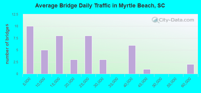
- 840,887Total average daily traffic
- 43,685Total average daily truck traffic
- National Bridge Inventory (NBI) Registered Bridges for Myrtle Beach
- No street view available for this location
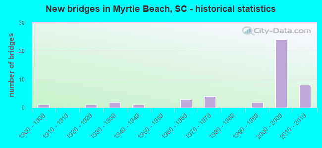
- New bridges - historical statistics
- 11900-1909
- 11920-1929
- 21930-1939
- 11940-1949
- 31960-1969
- 41970-1979
- 21990-1999
- 242000-2009
- 82010-2019
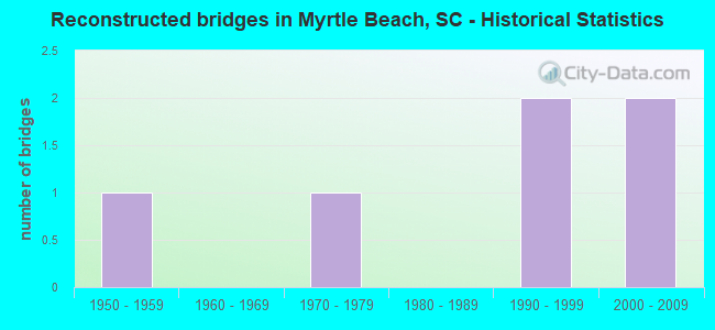
- Reconstructed bridges - Historical Statistics
- 11950-1959
- 01960-1969
- 11970-1979
- 01980-1989
- 21990-1999
- 22000-2009
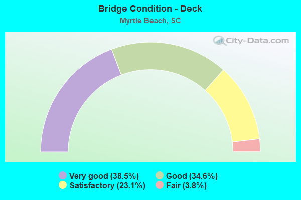
- Bridge Condition - Deck
- 38.5%Very good
- 34.6%Good
- 23.1%Satisfactory
- 3.8%Fair
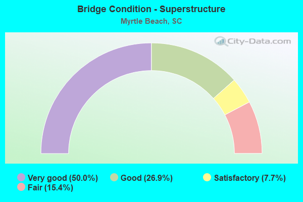
- Bridge Condition - Superstructure
- 50.0%Very good
- 26.9%Good
- 7.7%Satisfactory
- 15.4%Fair
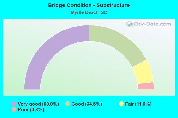
- Bridge Condition - Substructure
- 50.0%Very good
- 34.6%Good
- 11.5%Fair
- 3.8%Poor
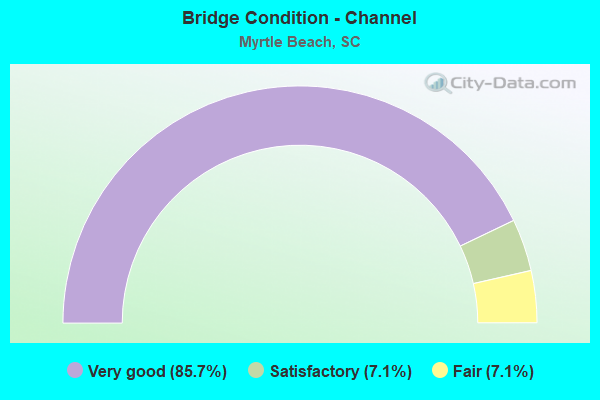
- Bridge Condition - Channel
- 85.7%Very good
- 7.1%Satisfactory
- 7.1%Fair
Find on map >> Show street view
Structure Number: 39, Location: 11.5 MI N OF LANCASTER (Lat: 34.908992, Lng: -80.811647), Route carried "on" structure: US 521, Year Built: 1900, Year Reconstructed: 1962, Status: Open, Structure Length: 3.96m (12.99ft), Average Daily Traffic: 9,050 (year 2020), Truck Traffic: 5%, Average Future Daily Traffic: 12,127 (year 2040), Design Load: H 15, Features Intersected: RR CSXT
Minimum Vertical Clearance: 30+ m (98+ ft), Kilometerpoint: 58.078, Lanes on structure: 2, Base Highway Network: Yes, Owner: State Highway Agency, Approaching Roadway Width: 13.4m (44.0ft), Material/Design: Concrete, Design/Construction: Tee Beam, Number Of Spans In Main Unit: 3, Number Of Approach Spans: 1, Length of Maximum Span: 11.3m (37.1ft), Curb-To-Curb Width: 11.1m (36.4ft), Out-to-Out Width: 12.6m (41.3ft)
Condition: Deck: Satisfactory, Superstructure: Fair, Substructure: Fair, Operating Rating: 26.6 metric tons, Method Used To Determine Operating Rating: Load and Resistance Factor Rating (LRFR) rating reported by rating factor(RF) method using HL-93 loadings, Inventory Rating: 20.4 metric tons, Method Used To Determine Inventory Rating: Load and Resistance Factor Rating (LRFR) rating reported by rating factor(RF) method using HL-93 loadings, Structural Evaluation: Somewhat better than minimum adequacy, Deck Geometry: Equal to present minimum criteria, Underclear: Meets minimum limits, Approach Roadway Alignment: Equal to present desirable criteria, Bridge Posting: Required (Relationship of Operating Rating to Maximum Legal Load: > 39.9% below), Length Of Structure Improvement: 4.85m (15.91ft), Designated Inspection Frequency: Every 24 months, Inspection Date: September 2020, Bridge Improvement Cost: $614,000, Roadway Improvement Cost: $154,000, Total Project Cost: $921,000 ( Estimate for 2021), Deck Structure Type: Concrete Cast-file-Place, Wearing Surface/Protective System: Wearing Surface: Bituminous
Find on map >> Show street view
Structure Number: 333, Location: CITY OF CHESTER (Lat: 34.698000, Lng: -81.226978), Route carried "on" structure: State highway 276, Year Built: 1929, Status: Open, Structure Length: 0.82m (2.69ft), Average Daily Traffic: 1,100 (year 2020), Truck Traffic: 5%, Average Future Daily Traffic: 1,551 (year 2040), Design Load: H 20, Features Intersected: TAN YARD BRANCH
Minimum Vertical Clearance: 30+ m (98+ ft), Kilometerpoint: 0.185, Lanes on structure: 2, Owner: State Highway Agency, Approaching Roadway Width: 14.6m (47.9ft), Material/Design: Concrete, Design/Construction: Culvert, Number Of Spans In Main Unit: 2, Length of Maximum Span: 3.7m (12.1ft), Curb-To-Curb Width: 14.6m (47.9ft), Out-to-Out Width: 18.9m (62.0ft)
Condition: Channel: Fair, Culverts: Satisfactory, Operating Rating: 30.8 metric tons, Method Used To Determine Operating Rating: Load and Resistance Factor Rating (LRFR) rating reported by rating factor(RF) method using HL-93 loadings, Inventory Rating: 23.7 metric tons, Method Used To Determine Inventory Rating: Load and Resistance Factor Rating (LRFR) rating reported by rating factor(RF) method using HL-93 loadings, Structural Evaluation: Equal to present minimum criteria, Deck Geometry: Superior to present desirable criteria, Waterway Adequacy: Better than present minimum criteria, Approach Roadway Alignment: Equal to present desirable criteria, Length Of Structure Improvement: 0.82m (2.69ft), Designated Inspection Frequency: Every 24 months, Inspection Date: Febuary 2021
Find on map >> Show street view
Structure Number: 734, Location: IN MYRTLE BEACH (Lat: 33.662156, Lng: -78.922722), Route carried "on" structure: Business US 17, Year Built: 1936, Year Reconstructed: 2005, Status: Open, Structure Length: 0.63m (2.07ft), Average Daily Traffic: 24,600 (year 2020), Truck Traffic: 4%, Average Future Daily Traffic: 30,750 (year 2040), Design Load: H 15, Features Intersected: MIDWAY SWASH
Minimum Vertical Clearance: 30+ m (98+ ft), Kilometerpoint: 13.924, Lanes on structure: 4, Base Highway Network: Yes, Owner: State Highway Agency, Approaching Roadway Width: 26.8m (87.9ft), Skew: 23 degrees, Material/Design: Concrete, Design/Construction: Culvert, Number Of Spans In Main Unit: 3, Length of Maximum Span: 2.4m (7.9ft), Curb-To-Curb Width: 34.1m (111.9ft), Out-to-Out Width: 34.1m (111.9ft)
Condition: Channel: Very good, Culverts: Satisfactory, Operating Rating: 24.3 metric tons, Method Used To Determine Operating Rating: Load and Resistance Factor Rating (LRFR) rating reported by rating factor(RF) method using HL-93 loadings, Inventory Rating: 18.8 metric tons, Method Used To Determine Inventory Rating: Load and Resistance Factor Rating (LRFR) rating reported by rating factor(RF) method using HL-93 loadings, Structural Evaluation: Meets minimum limits, Deck Geometry: Superior to present desirable criteria, Waterway Adequacy: Equal to present desirable criteria, Approach Roadway Alignment: Equal to present desirable criteria, Length Of Structure Improvement: 0.63m (2.07ft), Designated Inspection Frequency: Every 24 months, Inspection Date: August 2020
Find on map >> Show street view
Structure Number: 1495, Location: TOWN OF MYRTLE BEACH (Lat: 33.683817, Lng: -78.892631), Route carried "on" structure: Business US 17, Year Built: 1948, Year Reconstructed: 1977, Status: Open, Structure Length: 1.40m (4.59ft), Average Daily Traffic: 24,600 (year 2020), Truck Traffic: 4%, Average Future Daily Traffic: 30,750 (year 2040), Design Load: H 15, Features Intersected: WITHERS SWASH
Minimum Vertical Clearance: 30+ m (98+ ft), Kilometerpoint: 17.514, Lanes on structure: 4, Base Highway Network: Yes, Owner: State Highway Agency, Approaching Roadway Width: 22.6m (74.1ft), Skew: 20 degrees, Material/Design: Concrete, Design/Construction: Culvert, Number Of Spans In Main Unit: 4, Length of Maximum Span: 3.0m (9.8ft), Curb-To-Curb Width: 20.7m (67.9ft), Out-to-Out Width: 30.5m (100.1ft)
Condition: Channel: Satisfactory, Culverts: Satisfactory, Operating Rating: 79.4 metric tons, Method Used To Determine Operating Rating: Load and Resistance Factor Rating (LRFR) rating reported by rating factor(RF) method using HL-93 loadings, Inventory Rating: 61.2 metric tons, Method Used To Determine Inventory Rating: Load and Resistance Factor Rating (LRFR) rating reported by rating factor(RF) method using HL-93 loadings, Structural Evaluation: Equal to present minimum criteria, Deck Geometry: Superior to present desirable criteria, Waterway Adequacy: Equal to present desirable criteria, Approach Roadway Alignment: Equal to present desirable criteria, Length Of Structure Improvement: 1.40m (4.59ft), Designated Inspection Frequency: Every 24 months, Underwater Inspection Frequency: Every 60 months, Inspection Date: August 2020, Underwater Inspection Date: October 2021
Find on map >> Show street view
Structure Number: 333, Location: TOWN OF MYRTLE BEACH (Lat: 33.690819, Lng: -78.893433), Route carried "on" structure: State highway 15, Year Built: 2018, Status: Open, Structure Length: 2.13m (6.99ft), Average Daily Traffic: 7,400 (year 2020), Truck Traffic: 2%, Average Future Daily Traffic: 9,028 (year 2040), Design Load: HL 93, Features Intersected: WITHERS SWASH
Minimum Vertical Clearance: 30+ m (98+ ft), Kilometerpoint: 0.927, Lanes on structure: 2, Owner: State Highway Agency, Approaching Roadway Width: 9.1m (29.9ft), Material/Design: Prestressed concrete, Design/Construction: Stringer/Multi-beam, Number Of Spans In Main Unit: 1, Length of Maximum Span: 21.3m (69.9ft), Curb or Sidewalk Widths: Left: 1.7m (5.6ft), Right: 1.7m (5.6ft), Curb-To-Curb Width: 9.1m (29.9ft), Out-to-Out Width: 13.4m (44.0ft)
Condition: Deck: Good, Superstructure: Very good, Substructure: Good, Channel: Very good, Operating Rating: 59.3 metric tons, Method Used To Determine Operating Rating: Load and Resistance Factor Rating (LRFR) rating reported by rating factor(RF) method using HL-93 loadings, Inventory Rating: 33.0 metric tons, Method Used To Determine Inventory Rating: Load and Resistance Factor Rating (LRFR) rating reported by rating factor(RF) method using HL-93 loadings, Structural Evaluation: Better than present minimum criteria, Deck Geometry: High priority of corrective action, Waterway Adequacy: Superior to present desirable criteria, Approach Roadway Alignment: Equal to present desirable criteria, Length Of Structure Improvement: 2.13m (6.99ft), Designated Inspection Frequency: Every 24 months, Inspection Date: August 2020, Deck Structure Type: Concrete Cast-file-Place, Wearing Surface/Protective System: Wearing Surface: Monolithic Concrete
Find on map >> Show street view
Structure Number: 3899, Location: CITY OF MYRTLE BEACH (Lat: 33.659806, Lng: -78.917758), Route carried "on" structure: County highway 73, Year Built: 1962, Status: Open, Structure Length: 0.70m (2.30ft), Average Daily Traffic: 6,000 (year 2020), Truck Traffic: 4%, Average Future Daily Traffic: 7,320 (year 2040), Design Load: H 20, Features Intersected: MIDWAY SWASH
Minimum Vertical Clearance: 30+ m (98+ ft), Kilometerpoint: 1.012, Lanes on structure: 4, Owner: County Highway Agency, Approaching Roadway Width: 15.8m (51.8ft), Material/Design: Concrete, Design/Construction: Culvert, Number Of Spans In Main Unit: 2, Length of Maximum Span: 3.0m (9.8ft), Curb-To-Curb Width: 21.9m (71.9ft), Out-to-Out Width: 36.1m (118.4ft)
Condition: Channel: Very good, Culverts: Satisfactory, Operating Rating: 37.3 metric tons, Method Used To Determine Operating Rating: Load and Resistance Factor Rating (LRFR) rating reported by rating factor(RF) method using HL-93 loadings, Inventory Rating: 28.8 metric tons, Method Used To Determine Inventory Rating: Load and Resistance Factor Rating (LRFR) rating reported by rating factor(RF) method using HL-93 loadings, Structural Evaluation: Equal to present minimum criteria, Deck Geometry: Superior to present desirable criteria, Waterway Adequacy: Equal to present desirable criteria, Approach Roadway Alignment: Equal to present desirable criteria, Length Of Structure Improvement: 0.70m (2.30ft), Designated Inspection Frequency: Every 24 months, Underwater Inspection Frequency: Every 60 months, Inspection Date: December 2021, Underwater Inspection Date: October 2021
Find on map >> Show street view
Structure Number: 39, Location: CITY OF MYRTLE BEACH (Lat: 33.681047, Lng: -78.891333), Route carried "on" structure: County highway 73, Year Built: 2000, Status: Open, Structure Length: 1.71m (5.61ft), Average Daily Traffic: 11,400 (year 2020), Truck Traffic: 2%, Average Future Daily Traffic: 13,908 (year 2040), Design Load: HS 20, Features Intersected: WITHERS SWASH
Minimum Vertical Clearance: 30+ m (98+ ft), Kilometerpoint: 4.419, Lanes on structure: 4, Owner: County Highway Agency, Approaching Roadway Width: 13.4m (44.0ft), Material/Design: Concrete continuous, Design/Construction: Slab, Number Of Spans In Main Unit: 2, Length of Maximum Span: 8.5m (27.9ft), Curb or Sidewalk Widths: Left: 2.0m (6.6ft), Right: 2.0m (6.6ft), Curb-To-Curb Width: 13.4m (44.0ft), Out-to-Out Width: 18.7m (61.4ft)
Condition: Deck: Satisfactory, Superstructure: Satisfactory, Substructure: Very good, Channel: Very good, Operating Rating: 68.7 metric tons, Method Used To Determine Operating Rating: Load and Resistance Factor Rating (LRFR) rating reported by rating factor(RF) method using HL-93 loadings, Inventory Rating: 53.1 metric tons, Method Used To Determine Inventory Rating: Load and Resistance Factor Rating (LRFR) rating reported by rating factor(RF) method using HL-93 loadings, Structural Evaluation: Equal to present minimum criteria, Deck Geometry: High priority of replacement, Waterway Adequacy: Equal to present desirable criteria, Approach Roadway Alignment: Equal to present desirable criteria, Length Of Structure Improvement: 2.43m (7.97ft), Designated Inspection Frequency: Every 24 months, Inspection Date: December 2021, Bridge Improvement Cost: $79,000, Roadway Improvement Cost: $20,000, Total Project Cost: $119,000 ( Estimate for 2021), Deck Structure Type: Concrete Cast-file-Place, Wearing Surface/Protective System: Wearing Surface: Monolithic Concrete
Find on map >> Show street view
Structure Number: 4147, Location: 3.0 MI W OF MYRTLE BEACH (Lat: 33.714250, Lng: -78.922033), Route carried "on" structure: US 501, Year Built: 1963, Status: Open, Structure Length: 20.12m (66.01ft), Average Daily Traffic: 57,000 (year 2020), Truck Traffic: 11%, Average Future Daily Traffic: 71,250 (year 2040), Design Load: HS 20, Features Intersected: INTERCOASTAL WATERWAY
Minimum Vertical Clearance: 30+ m (98+ ft), Kilometerpoint: 49.791, Lanes on structure: 4, Lanes under structure: 6, Base Highway Network: Yes, Owner: State Highway Agency, Approaching Roadway Width: 16.8m (55.1ft), Skew: 20 degrees, Navigation Control: Yes ( Vertical Clearance: 19.8m (65.0ft), Horizontal Clearance: 27.4m (89.9ft)), Material/Design: Steel continuous, Design/Construction: Stringer/Multi-beam, Number Of Spans In Main Unit: 3, Number Of Approach Spans: 6, Length of Maximum Span: 42.7m (140.1ft), Curb or Sidewalk Widths: Left: 0.6m (2.0ft), Right: 0.6m (2.0ft), Curb-To-Curb Width: 15.8m (51.8ft), Out-to-Out Width: 18.7m (61.4ft)
Condition: Deck: Fair, Superstructure: Fair, Substructure: Fair, Channel: Very good, Operating Rating: 28.2 metric tons, Method Used To Determine Operating Rating: Load and Resistance Factor Rating (LRFR) rating reported by rating factor(RF) method using HL-93 loadings, Inventory Rating: 21.7 metric tons, Method Used To Determine Inventory Rating: Load and Resistance Factor Rating (LRFR) rating reported by rating factor(RF) method using HL-93 loadings, Structural Evaluation: Somewhat better than minimum adequacy, Deck Geometry: Meets minimum limits, Waterway Adequacy: Equal to present desirable criteria, Approach Roadway Alignment: Equal to present desirable criteria, Length Of Structure Improvement: 20.12m (66.01ft), Designated Inspection Frequency: Every 24 months, Underwater Inspection Frequency: Every 60 months, Inspection Date: November 2020, Underwater Inspection Date: March 2021, Deck Structure Type: Concrete Cast-file-Place, Wearing Surface/Protective System: Wearing Surface: Monolithic Concrete
Find on map >> Show street view
Structure Number: 4813, Location: 5TH AVE MYRTLE BEACH (Lat: 33.685183, Lng: -78.897411), Route carried "on" structure: State highway 351, Year Built: 1966, Status: Posted for load, Structure Length: 0.91m (2.99ft), Average Daily Traffic: 1,150 (year 2021), Truck Traffic: 5%, Average Future Daily Traffic: 1,472 (year 2041), Design Load: H 10, Features Intersected: MYRTLE SWASH
Minimum Vertical Clearance: 30+ m (98+ ft), Kilometerpoint: 0.401, Lanes on structure: 2, Owner: State Highway Agency, Approaching Roadway Width: 7.0m (23.0ft), Material/Design: Concrete, Design/Construction: Slab, Number Of Spans In Main Unit: 2, Length of Maximum Span: 4.6m (15.1ft), Curb-To-Curb Width: 7.9m (25.9ft), Out-to-Out Width: 8.5m (27.9ft)
Condition: Deck: Satisfactory, Superstructure: Satisfactory, Substructure: Poor, Channel: Very good, Operating Rating: 19.1 metric tons, Method Used To Determine Operating Rating: Load and Resistance Factor Rating (LRFR) rating reported by rating factor(RF) method using HL-93 loadings, Inventory Rating: 14.6 metric tons, Method Used To Determine Inventory Rating: Load and Resistance Factor Rating (LRFR) rating reported by rating factor(RF) method using HL-93 loadings, Structural Evaluation: Meets minimum limits, Deck Geometry: Meets minimum limits, Waterway Adequacy: Superior to present desirable criteria, Approach Roadway Alignment: Equal to present desirable criteria, Bridge Posting: Required (Relationship of Operating Rating to Maximum Legal Load: 30.0 - 39.9% below), Length Of Structure Improvement: 1.55m (5.09ft), Designated Inspection Frequency: Every 12 months, Inspection Date: August 2021, Bridge Improvement Cost: $157,000, Roadway Improvement Cost: $39,000, Total Project Cost: $236,000 ( Estimate for 2022), Deck Structure Type: Concrete Precast Panels, Wearing Surface/Protective System: Wearing Surface: Bituminous
Find on map >> Show street view
Structure Number: 6509, Location: 7.0MI NE OF MYRTLE BEACH (Lat: 33.767444, Lng: -78.805142), Route carried "on" structure: US 17, Year Built: 1974, Status: Open, Structure Length: 9.24m (30.31ft), Average Daily Traffic: 26,600 (year 2020), Truck Traffic: 4%, Average Future Daily Traffic: 33,250 (year 2040), Design Load: HS 20, Features Intersected: U.S. 17 BUS.
Minimum Vertical Clearance: 5.72m (18.77ft), Kilometerpoint: 31.495, Lanes on structure: 3, Lanes under structure: 4, Base Highway Network: Yes, Owner: State Highway Agency, Approaching Roadway Width: 13.4m (44.0ft), Skew: 24 degrees, Material/Design: Steel continuous, Design/Construction: Stringer/Multi-beam, Number Of Spans In Main Unit: 4, Length of Maximum Span: 31.4m (103.0ft), Curb-To-Curb Width: 19.5m (64.0ft), Out-to-Out Width: 20.5m (67.3ft)
Condition: Deck: Satisfactory, Superstructure: Fair, Substructure: Good, Operating Rating: 36.3 metric tons, Method Used To Determine Operating Rating: Load and Resistance Factor Rating (LRFR) rating reported by rating factor(RF) method using HL-93 loadings, Inventory Rating: 27.9 metric tons, Method Used To Determine Inventory Rating: Load and Resistance Factor Rating (LRFR) rating reported by rating factor(RF) method using HL-93 loadings, Structural Evaluation: Somewhat better than minimum adequacy, Deck Geometry: Superior to present desirable criteria, Underclear: Superior to present desirable criteria, Approach Roadway Alignment: Equal to present desirable criteria, Length Of Structure Improvement: 10.33m (33.89ft), Designated Inspection Frequency: Every 24 months, Inspection Date: November 2020, Deck Structure Type: Concrete Cast-file-Place, Wearing Surface/Protective System: Wearing Surface: Monolithic Concrete
Find on map >> Show street view
Structure Number: 651, Location: 2.0MI NW OF MYRTLE BEACH (Lat: 33.709044, Lng: -78.914017), Route carried "on" structure: US 17, Year Built: 1974, Year Reconstructed: 2004, Status: Open, Structure Length: 11.28m (37.01ft), Average Daily Traffic: 36,100 (year 2020), Truck Traffic: 3%, Average Future Daily Traffic: 45,125 (year 2040), Design Load: HS 25 or greater, Features Intersected: U.S. 501
Minimum Vertical Clearance: 30+ m (98+ ft), Kilometerpoint: 19.344, Lanes on structure: 8, Lanes under structure: 6, Base Highway Network: Yes, Owner: State Highway Agency, Approaching Roadway Width: 26.8m (87.9ft), Skew: 23 degrees, Material/Design: Steel, Design/Construction: Stringer/Multi-beam, Number Of Spans In Main Unit: 5, Length of Maximum Span: 27.4m (89.9ft), Curb-To-Curb Width: 35.5m (116.5ft), Out-to-Out Width: 36.5m (119.8ft)
Condition: Deck: Satisfactory, Superstructure: Good, Substructure: Good, Operating Rating: 50.5 metric tons, Method Used To Determine Operating Rating: Load and Resistance Factor Rating (LRFR) rating reported by rating factor(RF) method using HL-93 loadings, Inventory Rating: 38.9 metric tons, Method Used To Determine Inventory Rating: Load and Resistance Factor Rating (LRFR) rating reported by rating factor(RF) method using HL-93 loadings, Structural Evaluation: Better than present minimum criteria, Deck Geometry: Superior to present desirable criteria, Underclear: Better than present minimum criteria, Approach Roadway Alignment: Equal to present desirable criteria, Length Of Structure Improvement: 11.28m (37.01ft), Designated Inspection Frequency: Every 24 months, Inspection Date: November 2020, Deck Structure Type: Concrete Cast-file-Place, Wearing Surface/Protective System: Wearing Surface: Monolithic Concrete
Find on map >> Show street view
Structure Number: 9654, Location: IN MYRTLE BEACH (Lat: 33.718333, Lng: -78.886667), Route carried "on" structure: US 17, Year Built: 1992, Year Reconstructed: 2003, Status: Open, Structure Length: 2.74m (8.99ft), Average Daily Traffic: 18,050 (year 2020), Truck Traffic: 3%, Average Future Daily Traffic: 22,563 (year 2040), Design Load: HS 20+Mod, Features Intersected: BROADWAY CANAL
Minimum Vertical Clearance: 30+ m (98+ ft), Kilometerpoint: 22.203, Lanes on structure: 6, Base Highway Network: Yes, Owner: State Highway Agency, Approaching Roadway Width: 26.8m (87.9ft), Skew: 23 degrees, Material/Design: Concrete continuous, Design/Construction: Slab, Number Of Spans In Main Unit: 3, Length of Maximum Span: 9.1m (29.9ft), Curb-To-Curb Width: 30.5m (100.1ft), Out-to-Out Width: 32.5m (106.6ft)
Condition: Deck: Good, Superstructure: Good, Substructure: Very good, Channel: Very good, Operating Rating: 48.6 metric tons, Method Used To Determine Operating Rating: Load and Resistance Factor Rating (LRFR) rating reported by rating factor(RF) method using HL-93 loadings, Inventory Rating: 37.6 metric tons, Method Used To Determine Inventory Rating: Load and Resistance Factor Rating (LRFR) rating reported by rating factor(RF) method using HL-93 loadings, Structural Evaluation: Better than present minimum criteria, Deck Geometry: Superior to present desirable criteria, Waterway Adequacy: Equal to present desirable criteria, Approach Roadway Alignment: Equal to present desirable criteria, Length Of Structure Improvement: 2.74m (8.99ft), Designated Inspection Frequency: Every 24 months, Inspection Date: November 2020, Deck Structure Type: Concrete Cast-file-Place, Wearing Surface/Protective System: Wearing Surface: Monolithic Concrete
Find on map >> Show street view
Structure Number: 978, Location: 9.6 MI NE SOCASTEE (Lat: 33.750833, Lng: -78.868611), Route carried "on" structure: State highway 31, Year Built: 2002, Status: Open, Structure Length: 6.23m (20.44ft), Average Daily Traffic: 13,300 (year 2020), Truck Traffic: 7%, Average Future Daily Traffic: 38,437 (year 2040), Design Load: HS 20, Features Intersected: L-1244/RIVER OAKS DR
Minimum Vertical Clearance: 5.49m (18.01ft), Kilometerpoint: 23.794, Lanes on structure: 3, Lanes under structure: 2, Base Highway Network: Yes, Owner: State Highway Agency, Approaching Roadway Width: 15.2m (49.9ft), Skew: 13 degrees, Material/Design: Prestressed concrete continuous, Design/Construction: Stringer/Multi-beam, Number Of Spans In Main Unit: 2, Length of Maximum Span: 31.1m (102.0ft), Curb-To-Curb Width: 17.1m (56.1ft), Out-to-Out Width: 18.0m (59.1ft)
Condition: Deck: Good, Superstructure: Very good, Substructure: Good, Operating Rating: 73.9 metric tons, Method Used To Determine Operating Rating: Load and Resistance Factor Rating (LRFR) rating reported by rating factor(RF) method using HL-93 loadings, Inventory Rating: 52.5 metric tons, Method Used To Determine Inventory Rating: Load and Resistance Factor Rating (LRFR) rating reported by rating factor(RF) method using HL-93 loadings, Structural Evaluation: Better than present minimum criteria, Deck Geometry: Equal to present minimum criteria, Underclear: High priority of corrective action, Approach Roadway Alignment: Equal to present desirable criteria, Length Of Structure Improvement: 6.23m (20.44ft), Designated Inspection Frequency: Every 24 months, Inspection Date: October 2020, Deck Structure Type: Concrete Cast-file-Place, Wearing Surface/Protective System: Wearing Surface: Monolithic Concrete
Find on map >> Show street view
Structure Number: 9781, Location: 9.6 MI NE SOCASTEE (Lat: 33.750653, Lng: -78.868500), Route carried "on" structure: State highway 31, Year Built: 2002, Status: Open, Structure Length: 6.40m (21.00ft), Average Daily Traffic: 13,300 (year 2020), Truck Traffic: 7%, Average Future Daily Traffic: 38,437 (year 2040), Design Load: HS 20, Features Intersected: L-1244/RIVER OAKS DR
Minimum Vertical Clearance: 5.59m (18.34ft), Kilometerpoint: 23.838, Lanes on structure: 3, Lanes under structure: 2, Base Highway Network: Yes, Owner: State Highway Agency, Approaching Roadway Width: 15.2m (49.9ft), Skew: 13 degrees, Material/Design: Prestressed concrete continuous, Design/Construction: Stringer/Multi-beam, Number Of Spans In Main Unit: 2, Length of Maximum Span: 32.9m (107.9ft), Curb-To-Curb Width: 17.1m (56.1ft), Out-to-Out Width: 18.0m (59.1ft)
Condition: Deck: Good, Superstructure: Good, Substructure: Good, Operating Rating: 72.6 metric tons, Method Used To Determine Operating Rating: Load and Resistance Factor Rating (LRFR) rating reported by rating factor(RF) method using HL-93 loadings, Inventory Rating: 52.8 metric tons, Method Used To Determine Inventory Rating: Load and Resistance Factor Rating (LRFR) rating reported by rating factor(RF) method using HL-93 loadings, Structural Evaluation: Better than present minimum criteria, Deck Geometry: Equal to present minimum criteria, Underclear: Meets minimum limits, Approach Roadway Alignment: Equal to present desirable criteria, Length Of Structure Improvement: 6.40m (21.00ft), Designated Inspection Frequency: Every 24 months, Inspection Date: October 2020, Deck Structure Type: Concrete Cast-file-Place, Wearing Surface/Protective System: Wearing Surface: Monolithic Concrete
Find on map >> Show street view
Structure Number: 9796, Location: IN MYRTLE BEACH (Lat: 33.739325, Lng: -78.850208), Route carried "on" structure: State highway 1315, Year Built: 2002, Status: Open, Structure Length: 5.03m (16.50ft), Average Daily Traffic: 10,950 (year 2020), Truck Traffic: 2%, Average Future Daily Traffic: 13,688 (year 2040), Design Load: HS 25 or greater, Features Intersected: US 17
Minimum Vertical Clearance: 30+ m (98+ ft), Kilometerpoint: 9.186, Lanes on structure: 3, Lanes under structure: 6, Base Highway Network: Yes, Owner: State Highway Agency, Approaching Roadway Width: 15.8m (51.8ft), Skew: 11 degrees, Material/Design: Prestressed concrete, Design/Construction: Stringer/Multi-beam, Number Of Spans In Main Unit: 2, Length of Maximum Span: 25.3m (83.0ft), Curb-To-Curb Width: 15.8m (51.8ft), Out-to-Out Width: 16.8m (55.1ft)
Condition: Deck: Very good, Superstructure: Very good, Substructure: Very good, Operating Rating: 67.1 metric tons, Method Used To Determine Operating Rating: Load and Resistance Factor Rating (LRFR) rating reported by rating factor(RF) method using HL-93 loadings, Inventory Rating: 51.8 metric tons, Method Used To Determine Inventory Rating: Load and Resistance Factor Rating (LRFR) rating reported by rating factor(RF) method using HL-93 loadings, Structural Evaluation: Equal to present desirable criteria, Deck Geometry: Better than present minimum criteria, Underclear: Somewhat better than minimum adequacy, Approach Roadway Alignment: Equal to present desirable criteria, Length Of Structure Improvement: 5.03m (16.50ft), Designated Inspection Frequency: Every 24 months, Inspection Date: August 2021, Deck Structure Type: Concrete Cast-file-Place, Wearing Surface/Protective System: Wearing Surface: Monolithic Concrete
Find on map >> Show street view
Structure Number: 9797, Location: IN MYRTLE BEACH (Lat: 33.739258, Lng: -78.850414), Route carried "on" structure: State highway 1315, Year Built: 2002, Status: Open, Structure Length: 5.03m (16.50ft), Average Daily Traffic: 10,950 (year 2020), Truck Traffic: 2%, Average Future Daily Traffic: 13,688 (year 2040), Design Load: HS 25 or greater, Features Intersected: US 17
Minimum Vertical Clearance: 30+ m (98+ ft), Kilometerpoint: 9.186, Lanes on structure: 3, Lanes under structure: 6, Base Highway Network: Yes, Owner: State Highway Agency, Approaching Roadway Width: 14.3m (46.9ft), Skew: 11 degrees, Material/Design: Prestressed concrete, Design/Construction: Stringer/Multi-beam, Number Of Spans In Main Unit: 2, Length of Maximum Span: 25.3m (83.0ft), Curb-To-Curb Width: 15.8m (51.8ft), Out-to-Out Width: 16.8m (55.1ft)
Condition: Deck: Very good, Superstructure: Very good, Substructure: Very good, Operating Rating: 67.1 metric tons, Method Used To Determine Operating Rating: Load and Resistance Factor Rating (LRFR) rating reported by rating factor(RF) method using HL-93 loadings, Inventory Rating: 51.8 metric tons, Method Used To Determine Inventory Rating: Load and Resistance Factor Rating (LRFR) rating reported by rating factor(RF) method using HL-93 loadings, Structural Evaluation: Equal to present desirable criteria, Deck Geometry: Better than present minimum criteria, Underclear: Somewhat better than minimum adequacy, Approach Roadway Alignment: Equal to present desirable criteria, Length Of Structure Improvement: 5.03m (16.50ft), Designated Inspection Frequency: Every 24 months, Inspection Date: August 2021, Deck Structure Type: Concrete Cast-file-Place, Wearing Surface/Protective System: Wearing Surface: Monolithic Concrete
Find on map >> Show street view
Structure Number: 9798, Location: IN MYRTLE BEACH (Lat: 33.747614, Lng: -78.847731), Route carried "on" structure: State highway 1315, Year Built: 2002, Status: Open, Structure Length: 1.28m (4.20ft), Average Daily Traffic: 39,000 (year 2020), Truck Traffic: 3%, Average Future Daily Traffic: 48,750 (year 2040), Design Load: HS 25 or greater, Features Intersected: GRISSOM PARKWAY TUNNEL
Minimum Vertical Clearance: 30+ m (98+ ft), Kilometerpoint: 10.213, Lanes on structure: 4, Lanes under structure: 2, Base Highway Network: Yes, Owner: State Highway Agency, Approaching Roadway Width: 11.6m (38.1ft), Material/Design: Concrete, Design/Construction: Frame, Number Of Spans In Main Unit: 1, Length of Maximum Span: 12.8m (42.0ft), Curb-To-Curb Width: 24.4m (80.1ft), Out-to-Out Width: 42.9m (140.7ft)
Condition: Deck: Very good, Superstructure: Very good, Substructure: Very good, Operating Rating: 89.7 metric tons, Method Used To Determine Operating Rating: Load and Resistance Factor Rating (LRFR) rating reported by rating factor(RF) method using HL-93 loadings, Inventory Rating: 69.0 metric tons, Method Used To Determine Inventory Rating: Load and Resistance Factor Rating (LRFR) rating reported by rating factor(RF) method using HL-93 loadings, Structural Evaluation: Equal to present desirable criteria, Deck Geometry: Superior to present desirable criteria, Approach Roadway Alignment: Equal to present desirable criteria, Length Of Structure Improvement: 1.28m (4.20ft), Designated Inspection Frequency: Every 24 months, Inspection Date: August 2021, Deck Structure Type: Other, Wearing Surface/Protective System: Wearing Surface: Monolithic Concrete
Find on map >> Show street view
Structure Number: 9799, Location: 0.3 MI N. MYRTLE BEACH (Lat: 33.754053, Lng: -78.852575), Route carried "on" structure: State highway 1315, Year Built: 2002, Status: Open, Structure Length: 6.52m (21.39ft), Average Daily Traffic: 39,000 (year 2020), Truck Traffic: 3%, Average Future Daily Traffic: 48,750 (year 2040), Design Load: HS 25 or greater, Features Intersected: SC 31
Minimum Vertical Clearance: 5.64m (18.50ft), Kilometerpoint: 10.985, Lanes on structure: 5, Lanes under structure: 6, Base Highway Network: Yes, Owner: State Highway Agency, Approaching Roadway Width: 24.5m (80.4ft), Skew: 1 degrees, Material/Design: Prestressed concrete continuous, Design/Construction: Stringer/Multi-beam, Number Of Spans In Main Unit: 2, Length of Maximum Span: 32.6m (107.0ft), Curb-To-Curb Width: 25.1m (82.3ft), Out-to-Out Width: 26.1m (85.6ft)
Condition: Deck: Good, Superstructure: Very good, Substructure: Very good, Operating Rating: 40.8 metric tons, Method Used To Determine Operating Rating: Load and Resistance Factor Rating (LRFR) rating reported by rating factor(RF) method using HL-93 loadings, Inventory Rating: 31.4 metric tons, Method Used To Determine Inventory Rating: Load and Resistance Factor Rating (LRFR) rating reported by rating factor(RF) method using HL-93 loadings, Structural Evaluation: Better than present minimum criteria, Deck Geometry: Superior to present desirable criteria, Underclear: Better than present minimum criteria, Approach Roadway Alignment: Equal to present desirable criteria, Length Of Structure Improvement: 6.52m (21.39ft), Designated Inspection Frequency: Every 24 months, Inspection Date: August 2021, Deck Structure Type: Concrete Cast-file-Place, Wearing Surface/Protective System: Wearing Surface: Monolithic Concrete
Find on map >> Show street view
Structure Number: 9877, Location: 5 N. OF MYRTLE BEACH (Lat: 33.720417, Lng: -78.930000), Route carried "on" structure: US 501, Year Built: 2004, Status: Open, Structure Length: 10.20m (33.46ft), Average Daily Traffic: 28,500 (year 2020), Truck Traffic: 11%, Average Future Daily Traffic: 35,625 (year 2040), Design Load: HS 25 or greater, Features Intersected: GEORGE BISHOP RD
Minimum Vertical Clearance: 6.12m (20.08ft), Kilometerpoint: 48.840, Lanes on structure: 2, Lanes under structure: 6, Base Highway Network: Yes, Owner: State Highway Agency, Approaching Roadway Width: 13.4m (44.0ft), Skew: 10 degrees, Material/Design: Prestressed concrete continuous, Design/Construction: Stringer/Multi-beam, Number Of Spans In Main Unit: 3, Length of Maximum Span: 34.1m (111.9ft), Curb-To-Curb Width: 13.4m (44.0ft), Out-to-Out Width: 14.3m (46.9ft)
Condition: Deck: Good, Superstructure: Good, Substructure: Good, Operating Rating: 64.2 metric tons, Method Used To Determine Operating Rating: Load and Resistance Factor Rating (LRFR) rating reported by rating factor(RF) method using HL-93 loadings, Inventory Rating: 37.6 metric tons, Method Used To Determine Inventory Rating: Load and Resistance Factor Rating (LRFR) rating reported by rating factor(RF) method using HL-93 loadings, Structural Evaluation: Better than present minimum criteria, Deck Geometry: Superior to present desirable criteria, Underclear: Superior to present desirable criteria, Approach Roadway Alignment: Equal to present desirable criteria, Length Of Structure Improvement: 10.20m (33.46ft), Designated Inspection Frequency: Every 24 months, Inspection Date: November 2020, Deck Structure Type: Concrete Cast-file-Place, Wearing Surface/Protective System: Wearing Surface: Monolithic Concrete
Find on map >> Show street view
Structure Number: 9878, Location: 5 N. OF MYRTLE BEACH (Lat: 33.720222, Lng: -78.930250), Route carried "on" structure: US 501, Year Built: 2004, Status: Open, Structure Length: 10.20m (33.46ft), Average Daily Traffic: 28,500 (year 2020), Truck Traffic: 11%, Average Future Daily Traffic: 35,625 (year 2040), Design Load: HS 25 or greater, Features Intersected: GEORGE BISHOP RD
Minimum Vertical Clearance: 5.89m (19.32ft), Kilometerpoint: 48.840, Lanes on structure: 2, Lanes under structure: 6, Base Highway Network: Yes, Owner: State Highway Agency, Approaching Roadway Width: 13.4m (44.0ft), Skew: 10 degrees, Material/Design: Prestressed concrete continuous, Design/Construction: Stringer/Multi-beam, Number Of Spans In Main Unit: 3, Length of Maximum Span: 34.1m (111.9ft), Curb-To-Curb Width: 13.4m (44.0ft), Out-to-Out Width: 14.3m (46.9ft)
Condition: Deck: Good, Superstructure: Good, Substructure: Good, Operating Rating: 64.2 metric tons, Method Used To Determine Operating Rating: Load and Resistance Factor Rating (LRFR) rating reported by rating factor(RF) method using HL-93 loadings, Inventory Rating: 37.6 metric tons, Method Used To Determine Inventory Rating: Load and Resistance Factor Rating (LRFR) rating reported by rating factor(RF) method using HL-93 loadings, Structural Evaluation: Better than present minimum criteria, Deck Geometry: Superior to present desirable criteria, Underclear: Better than present minimum criteria, Approach Roadway Alignment: Equal to present desirable criteria, Length Of Structure Improvement: 10.20m (33.46ft), Designated Inspection Frequency: Every 24 months, Other Special Inspection Frequency: Every 24 months, Inspection Date: November 2020, Other Special Inspection Date: May 2021, Deck Structure Type: Concrete Cast-file-Place, Wearing Surface/Protective System: Wearing Surface: Monolithic Concrete
Find on map >> Show street view
Structure Number: 9973, Location: MYRTLE BEACH (Lat: 33.803000, Lng: -78.741433), Route carried "on" structure: County highway 834, Year Built: 1938, Year Reconstructed: 2000, Status: Open, Structure Length: 18.23m (59.81ft), Average Daily Traffic: 5,400 (year 2021), Truck Traffic: 6%, Average Future Daily Traffic: 4,914 (year 2041), Design Load: H 15, Features Intersected: INTRACOASTAL WATERWAY
Minimum Vertical Clearance: 4.62m (15.16ft), Kilometerpoint: 0.520, Lanes on structure: 2, Owner: County Highway Agency, Approaching Roadway Width: 7.9m (25.9ft), Navigation Control: Yes ( Vertical Clearance: 32.3m (106.0ft), Horizontal Clearance: 9.1m (29.9ft)), Material/Design: Steel continuous, Design/Construction: Movable - Swing, Number Of Spans In Main Unit: 1, Number Of Approach Spans: 4, Length of Maximum Span: 100.0m (328.1ft), Curb-To-Curb Width: 8.9m (29.2ft), Out-to-Out Width: 9.1m (29.9ft)
Condition: Deck: Satisfactory, Superstructure: Fair, Substructure: Fair, Channel: Very good, Operating Rating: 22.4 metric tons, Method Used To Determine Operating Rating: Load and Resistance Factor Rating (LRFR) rating reported by rating factor(RF) method using HL-93 loadings, Inventory Rating: 17.2 metric tons, Method Used To Determine Inventory Rating: Load and Resistance Factor Rating (LRFR) rating reported by rating factor(RF) method using HL-93 loadings, Structural Evaluation: Meets minimum limits, Deck Geometry: High priority of corrective action, Waterway Adequacy: Equal to present desirable criteria, Approach Roadway Alignment: Equal to present desirable criteria, Bridge Posting: Required (Relationship of Operating Rating to Maximum Legal Load: 20.0 - 29.9% below), Length Of Structure Improvement: 18.23m (59.81ft), Designated Inspection Frequency: Every 12 months, Critical Feature Inspection Frequency: Every 12 months, Underwater Inspection Frequency: Every 60 months, Inspection Date: December 2021, Critical Feature Inspection Date: November 2021, Underwater Inspection Date: September 2021, Deck Structure Type: Closed Grating, Wearing Surface/Protective System: Wearing Surface: Monolithic Concrete
Find on map >> Show street view
Structure Number: 9996, Location: IN MYRTLE BEACH (Lat: 33.752322, Lng: -78.851203), Route carried "on" structure: State highway 1315, Year Built: 2002, Status: Open, Structure Length: 3.29m (10.79ft), Average Daily Traffic: 39,000 (year 2020), Truck Traffic: 3%, Average Future Daily Traffic: 48,750 (year 2040), Design Load: HS 25 or greater, Features Intersected: L-6311
Minimum Vertical Clearance: 30+ m (98+ ft), Kilometerpoint: 10.815, Lanes on structure: 5, Lanes under structure: 2, Base Highway Network: Yes, Owner: State Highway Agency, Approaching Roadway Width: 10.4m (34.1ft), Skew: 31 degrees, Material/Design: Prestressed concrete, Design/Construction: Stringer/Multi-beam, Number Of Spans In Main Unit: 1, Length of Maximum Span: 32.9m (107.9ft), Curb-To-Curb Width: 10.4m (34.1ft), Out-to-Out Width: 31.4m (103.0ft)
Condition: Deck: Very good, Superstructure: Very good, Substructure: Very good, Operating Rating: 65.4 metric tons, Method Used To Determine Operating Rating: Load and Resistance Factor Rating (LRFR) rating reported by rating factor(RF) method using HL-93 loadings, Inventory Rating: 36.3 metric tons, Method Used To Determine Inventory Rating: Load and Resistance Factor Rating (LRFR) rating reported by rating factor(RF) method using HL-93 loadings, Structural Evaluation: Equal to present desirable criteria, Deck Geometry: High priority of replacement, Underclear: Superior to present desirable criteria, Approach Roadway Alignment: Equal to present desirable criteria, Length Of Structure Improvement: 4.16m (13.65ft), Designated Inspection Frequency: Every 24 months, Inspection Date: August 2021, Bridge Improvement Cost: $295,000, Roadway Improvement Cost: $74,000, Total Project Cost: $443,000 ( Estimate for 2021), Deck Structure Type: Concrete Cast-file-Place, Wearing Surface/Protective System: Wearing Surface: Monolithic Concrete
Find on map >> Show street view
Structure Number: 9997, Location: IN MYRTLE BEACH (Lat: 33.752450, Lng: -78.850906), Route carried "on" structure: Ramp State highway 1315, Year Built: 2002, Status: Open, Structure Length: 3.35m (10.99ft), Average Daily Traffic: 10,200 (year 2015), Average Future Daily Traffic: 16,830 (year 2035), Design Load: HS 25 or greater, Features Intersected: FRONTAGE ROAD
Minimum Vertical Clearance: 30+ m (98+ ft), Kilometerpoint: 10.750, Lanes on structure: 1, Lanes under structure: 2, Base Highway Network: Yes, Owner: State Highway Agency, Approaching Roadway Width: 7.6m (24.9ft), Skew: 13 degrees, Material/Design: Prestressed concrete, Design/Construction: Stringer/Multi-beam, Number Of Spans In Main Unit: 1, Length of Maximum Span: 33.5m (109.9ft), Curb-To-Curb Width: 11.0m (36.1ft), Out-to-Out Width: 15.9m (52.2ft)
Condition: Deck: Very good, Superstructure: Very good, Substructure: Very good, Operating Rating: 62.9 metric tons, Method Used To Determine Operating Rating: Load and Resistance Factor Rating (LRFR) rating reported by rating factor(RF) method using HL-93 loadings, Inventory Rating: 39.9 metric tons, Method Used To Determine Inventory Rating: Load and Resistance Factor Rating (LRFR) rating reported by rating factor(RF) method using HL-93 loadings, Structural Evaluation: Equal to present desirable criteria, Deck Geometry: Superior to present desirable criteria, Underclear: Superior to present desirable criteria, Approach Roadway Alignment: Equal to present desirable criteria, Length Of Structure Improvement: 3.35m (10.99ft), Designated Inspection Frequency: Every 24 months, Inspection Date: August 2021, Deck Structure Type: Concrete Cast-file-Place, Wearing Surface/Protective System: Wearing Surface: Monolithic Concrete
Find on map >> Show street view
Structure Number: 10016, Location: MYRTLE BEACH (Lat: 33.749756, Lng: -78.849058), Route carried "on" structure: State highway 1315, Year Built: 2002, Status: Open, Structure Length: 18.29m (60.01ft), Average Daily Traffic: 39,000 (year 2020), Truck Traffic: 3%, Average Future Daily Traffic: 48,750 (year 2040), Design Load: HS 25 or greater, Features Intersected: ICWW
Minimum Vertical Clearance: 30+ m (98+ ft), Kilometerpoint: 10.385, Lanes on structure: 4, Base Highway Network: Yes, Owner: State Highway Agency, Approaching Roadway Width: 12.2m (40.0ft), Skew: 30 degrees, Navigation Control: Yes ( Vertical Clearance: 19.8m (65.0ft), Horizontal Clearance: 33.5m (109.9ft)), Material/Design: Prestressed concrete, Design/Construction: Stringer/Multi-beam, Number Of Spans In Main Unit: 5, Length of Maximum Span: 45.7m (149.9ft), Curb or Sidewalk Widths: Left: 0.0m, Right: 3.7m (12.1ft), Curb-To-Curb Width: 24.4m (80.1ft), Out-to-Out Width: 30.1m (98.8ft)
Condition: Deck: Very good, Superstructure: Very good, Substructure: Very good, Channel: Very good, Operating Rating: 47.0 metric tons, Method Used To Determine Operating Rating: Load and Resistance Factor Rating (LRFR) rating reported by rating factor(RF) method using HL-93 loadings, Inventory Rating: 20.7 metric tons, Method Used To Determine Inventory Rating: Load and Resistance Factor Rating (LRFR) rating reported by rating factor(RF) method using HL-93 loadings, Structural Evaluation: Somewhat better than minimum adequacy, Deck Geometry: Superior to present desirable criteria, Waterway Adequacy: Equal to present desirable criteria, Approach Roadway Alignment: Superior to present desirable criteria, Length Of Structure Improvement: 18.29m (60.01ft), Designated Inspection Frequency: Every 24 months, Inspection Date: August 2021, Deck Structure Type: Concrete Precast Panels, Wearing Surface/Protective System: Wearing Surface: Monolithic Concrete
Find on map >> Show street view
Structure Number: 10058, Location: CAROLINA FOREST BLVD (Lat: 33.758156, Lng: -78.916203), Route carried "on" structure: County highway 1895, Year Built: 1995, Status: Open, Structure Length: 1.83m (6.00ft), Average Daily Traffic: 4,400 (year 2020), Truck Traffic: 8%, Average Future Daily Traffic: 5,368 (year 2040), Design Load: HS 25 or greater, Features Intersected: UNNAMED CREEK
Minimum Vertical Clearance: 30+ m (98+ ft), Kilometerpoint: 8.275, Lanes on structure: 2, Owner: County Highway Agency, Approaching Roadway Width: 7.9m (25.9ft), Skew: 4 degrees, Material/Design: Concrete continuous, Design/Construction: Slab, Number Of Spans In Main Unit: 2, Length of Maximum Span: 9.1m (29.9ft), Curb-To-Curb Width: 12.2m (40.0ft), Out-to-Out Width: 12.8m (42.0ft)
Condition: Deck: Good, Superstructure: Good, Substructure: Very good, Channel: Very good, Operating Rating: 45.7 metric tons, Method Used To Determine Operating Rating: Load and Resistance Factor Rating (LRFR) rating reported by rating factor(RF) method using HL-93 loadings, Inventory Rating: 35.3 metric tons, Method Used To Determine Inventory Rating: Load and Resistance Factor Rating (LRFR) rating reported by rating factor(RF) method using HL-93 loadings, Structural Evaluation: Better than present minimum criteria, Deck Geometry: Better than present minimum criteria, Waterway Adequacy: Equal to present desirable criteria, Approach Roadway Alignment: Equal to present desirable criteria, Length Of Structure Improvement: 1.83m (6.00ft), Designated Inspection Frequency: Every 24 months, Inspection Date: December 2021, Deck Structure Type: Concrete Cast-file-Place, Wearing Surface/Protective System: Wearing Surface: Monolithic Concrete
Find on map >> Show street view
Structure Number: 10101, Location: MYRTLE BEACH CITY LIMIT (Lat: 33.684428, Lng: -78.959897), Route carried "on" structure: US 17, Year Built: 2017, Status: Open, Structure Length: 37.98m (124.61ft), Average Daily Traffic: 20,300 (year 2020), Truck Traffic: 3%, Average Future Daily Traffic: 25,375 (year 2040), Design Load: HL 93, Features Intersected: SC 707/L-2907
Minimum Vertical Clearance: 0.00m, Kilometerpoint: 14.077, Lanes on structure: 2, Lanes under structure: 6, Base Highway Network: Yes, Owner: State Highway Agency, Approaching Roadway Width: 14.6m (47.9ft), Material/Design: Steel continuous, Design/Construction: Stringer/Multi-beam, Number Of Spans In Main Unit: 1, Number Of Approach Spans: 5, Length of Maximum Span: 91.4m (299.9ft), Curb-To-Curb Width: 13.4m (44.0ft), Out-to-Out Width: 14.5m (47.6ft)
Condition: Deck: Very good, Superstructure: Very good, Substructure: Very good, Operating Rating: 22.4 metric tons, Method Used To Determine Operating Rating: Load and Resistance Factor Rating (LRFR) rating reported by rating factor(RF) method using HL-93 loadings, Inventory Rating: 17.2 metric tons, Method Used To Determine Inventory Rating: Load and Resistance Factor Rating (LRFR) rating reported by rating factor(RF) method using HL-93 loadings, Structural Evaluation: Meets minimum limits, Deck Geometry: Superior to present desirable criteria, Underclear: Equal to present minimum criteria, Approach Roadway Alignment: Equal to present desirable criteria, Bridge Posting: Required (Relationship of Operating Rating to Maximum Legal Load: > 39.9% below), Length Of Structure Improvement: 37.98m (124.61ft), Designated Inspection Frequency: Every 24 months, Inspection Date: June 2020, Deck Structure Type: Concrete Cast-file-Place
Find on map >> Show street view
Structure Number: 10102, Location: MYRTLE BEACH CITY LIMIT (Lat: 33.684544, Lng: -78.960047), Route carried "on" structure: US 17, Year Built: 2017, Status: Open, Structure Length: 37.98m (124.61ft), Average Daily Traffic: 20,300 (year 2020), Truck Traffic: 3%, Average Future Daily Traffic: 25,375 (year 2040), Design Load: HL 93, Features Intersected: SC 707/L-2907
Minimum Vertical Clearance: 0.00m, Kilometerpoint: 14.077, Lanes on structure: 2, Lanes under structure: 6, Base Highway Network: Yes, Owner: State Highway Agency, Approaching Roadway Width: 13.4m (44.0ft), Material/Design: Steel continuous, Design/Construction: Stringer/Multi-beam, Number Of Spans In Main Unit: 6, Length of Maximum Span: 91.4m (299.9ft), Curb-To-Curb Width: 13.4m (44.0ft), Out-to-Out Width: 14.3m (46.9ft)
Condition: Deck: Very good, Superstructure: Very good, Substructure: Very good, Operating Rating: 22.4 metric tons, Method Used To Determine Operating Rating: Load and Resistance Factor Rating (LRFR) rating reported by rating factor(RF) method using HL-93 loadings, Inventory Rating: 17.2 metric tons, Method Used To Determine Inventory Rating: Load and Resistance Factor Rating (LRFR) rating reported by rating factor(RF) method using HL-93 loadings, Structural Evaluation: Meets minimum limits, Deck Geometry: Superior to present desirable criteria, Underclear: Superior to present desirable criteria, Approach Roadway Alignment: Somewhat better than minimum adequacy, Bridge Posting: Required (Relationship of Operating Rating to Maximum Legal Load: > 39.9% below), Length Of Structure Improvement: 37.98m (124.61ft), Designated Inspection Frequency: Every 24 months, Inspection Date: June 2020, Bridge Improvement Cost: $4,805,000, Roadway Improvement Cost: $1,201,000, Total Project Cost: $7,208,000 ( Estimate for 2021), Deck Structure Type: Concrete Cast-file-Place, Wearing Surface/Protective System: Wearing Surface: Monolithic Concrete
Find on map >> Show street view
Structure Number: 10106, Location: MYRTLE BEACH (Lat: 33.703478, Lng: -78.930844), Route carried "on" structure: State highway 1244, Year Built: 2001, Status: Open, Structure Length: 6.40m (21.00ft), Average Daily Traffic: 22,600 (year 2020), Truck Traffic: 4%, Average Future Daily Traffic: 27,572 (year 2040), Design Load: HS 25 or greater, Features Intersected: US 17
Minimum Vertical Clearance: 5.28m (17.32ft), Kilometerpoint: 10.960, Lanes on structure: 6, Lanes under structure: 8, Owner: State Highway Agency, Approaching Roadway Width: 16.5m (54.1ft), Material/Design: Prestressed concrete continuous, Design/Construction: Stringer/Multi-beam, Number Of Spans In Main Unit: 2, Length of Maximum Span: 32.0m (105.0ft), Curb or Sidewalk Widths: Left: 0.0m, Right: 3.0m (9.8ft), Curb-To-Curb Width: 29.0m (95.1ft), Out-to-Out Width: 29.9m (98.1ft)
Condition: Deck: Very good, Superstructure: Very good, Substructure: Very good, Operating Rating: 37.3 metric tons, Method Used To Determine Operating Rating: Load and Resistance Factor Rating (LRFR) rating reported by rating factor(RF) method using HL-93 loadings, Inventory Rating: 10.4 metric tons, Method Used To Determine Inventory Rating: Load and Resistance Factor Rating (LRFR) rating reported by rating factor(RF) method using HL-93 loadings, Structural Evaluation: High priority of corrective action, Deck Geometry: Superior to present desirable criteria, Underclear: Equal to present minimum criteria, Approach Roadway Alignment: Equal to present desirable criteria, Length Of Structure Improvement: 7.39m (24.25ft), Designated Inspection Frequency: Every 24 months, Inspection Date: July 2021, Deck Structure Type: Concrete Cast-file-Place, Wearing Surface/Protective System: Wearing Surface: Monolithic Concrete
Find on map >> Show street view
Structure Number: 10107, Location: MYRTLE BEACH (Lat: 33.705803, Lng: -78.935125), Route carried "on" structure: State highway 1244, Year Built: 2010, Status: Open, Structure Length: 54.86m (179.99ft), Average Daily Traffic: 22,600 (year 2020), Truck Traffic: 4%, Average Future Daily Traffic: 27,572 (year 2040), Design Load: HL 93, Features Intersected: ICWW & L-3658
Minimum Vertical Clearance: 9.42m (30.91ft), Kilometerpoint: 10.279, Lanes on structure: 5, Lanes under structure: 6, Owner: State Highway Agency, Approaching Roadway Width: 22.7m (74.5ft), Navigation Control: Yes ( Vertical Clearance: 19.8m (65.0ft), Horizontal Clearance: 36.6m (120.1ft)), Material/Design: Steel continuous, Design/Construction: Stringer/Multi-beam, Number Of Spans In Main Unit: 3, Number Of Approach Spans: 9, Length of Maximum Span: 100.6m (330.1ft), Curb or Sidewalk Widths: Left: 0.0m, Right: 3.0m (9.8ft), Curb-To-Curb Width: 23.2m (76.1ft), Out-to-Out Width: 27.6m (90.6ft)
Condition: Deck: Good, Superstructure: Good, Substructure: Good, Channel: Very good, Operating Rating: 46.0 metric tons, Method Used To Determine Operating Rating: Load and Resistance Factor Rating (LRFR) rating reported by rating factor(RF) method using HL-93 loadings, Inventory Rating: 35.6 metric tons, Method Used To Determine Inventory Rating: Load and Resistance Factor Rating (LRFR) rating reported by rating factor(RF) method using HL-93 loadings, Structural Evaluation: Better than present minimum criteria, Deck Geometry: Better than present minimum criteria, Waterway Adequacy: Equal to present desirable criteria, Approach Roadway Alignment: Equal to present desirable criteria, Length Of Structure Improvement: 54.86m (179.99ft), Designated Inspection Frequency: Every 24 months, Inspection Date: December 2021, Deck Structure Type: Concrete Cast-file-Place, Wearing Surface/Protective System: Wearing Surface: Monolithic Concrete
Find on map >> Show street view
Structure Number: 10203, Location: MYRTLE BEACH (Lat: 33.834031, Lng: -78.684283), Route carried "on" structure: Ramp State highway 31, Year Built: 2010, Status: Open, Structure Length: 30.78m (100.98ft), Average Daily Traffic: 22,900 (year 2020), Truck Traffic: 3%, Average Future Daily Traffic: 27,938 (year 2040), Design Load: HL 93, Features Intersected: INTERCOASTAL WATERWAY
Minimum Vertical Clearance: 0.00m, Kilometerpoint: 0.592, Lanes on structure: 4, Owner: State Highway Agency, Approaching Roadway Width: 9.4m (30.8ft), Skew: 20 degrees, Navigation Control: Yes ( Vertical Clearance: 19.8m (65.0ft), Horizontal Clearance: 33.5m (109.9ft)), Material/Design: Prestressed concrete, Design/Construction: Stringer/Multi-beam, Number Of Spans In Main Unit: 3, Number Of Approach Spans: 5, Length of Maximum Span: 70.1m (230.0ft), Curb or Sidewalk Widths: Left: 0.0m, Right: 3.4m (11.2ft), Curb-To-Curb Width: 18.9m (62.0ft), Out-to-Out Width: 23.2m (76.1ft)
Condition: Deck: Very good, Superstructure: Very good, Substructure: Good, Channel: Very good, Operating Rating: 45.0 metric tons, Method Used To Determine Operating Rating: Load and Resistance Factor Rating (LRFR) rating reported by rating factor(RF) method using HL-93 loadings, Inventory Rating: 21.1 metric tons, Method Used To Determine Inventory Rating: Load and Resistance Factor Rating (LRFR) rating reported by rating factor(RF) method using HL-93 loadings, Structural Evaluation: Somewhat better than minimum adequacy, Deck Geometry: Superior to present desirable criteria, Waterway Adequacy: Equal to present desirable criteria, Approach Roadway Alignment: Equal to present desirable criteria, Length Of Structure Improvement: 30.78m (100.98ft), Designated Inspection Frequency: Every 24 months, Underwater Inspection Frequency: Every 60 months, Inspection Date: April 2020, Underwater Inspection Date: September 2021, Deck Structure Type: Concrete Cast-file-Place, Wearing Surface/Protective System: Wearing Surface: Integral Concrete
Find on map >> Show street view
Structure Number: 6509, Location: 7.0MI NE OF MYRTLE BEACH (Lat: 33.767444, Lng: -78.805142), Route carried "under" structure: Business US 17, Year Built: 1974, Structure Length: 0. m, Average Daily Traffic: 20,600 (year 2020), Truck Traffic: 2%, Features Intersected: U.S. 17 BUS.
Minimum Vertical Clearance: 5.72m (18.77ft), Kilometerpoint: 29.998, Lanes on structure: 3, Lanes under structure: 4, Material/Design: Steel continuous, Design/Construction: Stringer/Multi-beam, Length of Maximum Span: 31.4m (103.0ft)
Find on map >> Show street view
Structure Number: 651, Location: 2.0MI NW OF MYRTLE BEACH (Lat: 33.709044, Lng: -78.914017), Route carried "under" structure: US 501, Year Built: 1974, Structure Length: 0. m, Average Daily Traffic: 57,000 (year 2020), Truck Traffic: 11%, Features Intersected: U.S. 501, Facility Carried by Structure: US 17
Minimum Vertical Clearance: 6.99m (22.93ft), Kilometerpoint: 50.743, Lanes on structure: 8, Lanes under structure: 6, Material/Design: Steel, Design/Construction: Stringer/Multi-beam, Length of Maximum Span: 27.4m (89.9ft)
Find on map >> Show street view
Structure Number: 978, Location: 9.6 MI NE SOCASTEE (Lat: 33.750833, Lng: -78.868611), Route carried "under" structure: County highway 1244, Year Built: 2002, Structure Length: 0. m, Average Daily Traffic: 100 (year 2020), Truck Traffic: 8%, Features Intersected: L-1244/RIVER OAKS DR, Facility Carried by Structure: SC 31 SB
Minimum Vertical Clearance: 30+ m (98+ ft), Kilometerpoint: 1.423, Lanes on structure: 3, Lanes under structure: 2, Material/Design: Prestressed concrete continuous, Design/Construction: Stringer/Multi-beam, Length of Maximum Span: 31.1m (102.0ft)
Find on map >> Show street view
Structure Number: 9781, Location: 9.6 MI NE SOCASTEE (Lat: 33.750653, Lng: -78.868500), Route carried "under" structure: County highway 1244, Year Built: 2002, Structure Length: 0. m, Average Daily Traffic: 6,950 (year 2020), Truck Traffic: 3%, Features Intersected: L-1244/RIVER OAKS DR, Facility Carried by Structure: SC 31 NBL
Minimum Vertical Clearance: 30+ m (98+ ft), Kilometerpoint: 1.442, Lanes on structure: 3, Lanes under structure: 2, Material/Design: Prestressed concrete continuous, Design/Construction: Stringer/Multi-beam, Length of Maximum Span: 32.9m (107.9ft)
Find on map >> Show street view
Structure Number: 9796, Location: IN MYRTLE BEACH (Lat: 33.739325, Lng: -78.850208), Route carried "under" structure: US 17, Year Built: 2002, Structure Length: 0. m, Average Daily Traffic: 17,000 (year 2020), Truck Traffic: 3%, Features Intersected: US 17, Facility Carried by Structure: S-26-1315 NB
Minimum Vertical Clearance: 5.49m (18.01ft), Kilometerpoint: 26.240, Lanes on structure: 3, Lanes under structure: 6, Material/Design: Prestressed concrete, Design/Construction: Stringer/Multi-beam, Length of Maximum Span: 25.3m (83.0ft)
Find on map >> Show street view
Structure Number: 9797, Location: IN MYRTLE BEACH (Lat: 33.739258, Lng: -78.850414), Route carried "under" structure: US 17, Year Built: 2002, Structure Length: 0. m, Average Daily Traffic: 17,000 (year 2020), Truck Traffic: 3%, Features Intersected: US 17, Facility Carried by Structure: S-26-1315 SB
Minimum Vertical Clearance: 5.49m (18.01ft), Kilometerpoint: 26.240, Lanes on structure: 3, Lanes under structure: 6, Material/Design: Prestressed concrete, Design/Construction: Stringer/Multi-beam, Length of Maximum Span: 25.3m (83.0ft)
Find on map >> Show street view
Structure Number: 9798, Location: IN MYRTLE BEACH (Lat: 33.747614, Lng: -78.847731), Route carried "under" structure: County highway 7598, Year Built: 2002, Structure Length: 0. m, Average Daily Traffic: 225 (year 2020), Truck Traffic: 5%, Features Intersected: GRISSOM PARKWAY TUNNEL, Facility Carried by Structure: S-26-1315
Minimum Vertical Clearance: 30+ m (98+ ft), Kilometerpoint: 0.645, Lanes on structure: 4, Lanes under structure: 2, Material/Design: Concrete, Design/Construction: Frame, Length of Maximum Span: 12.8m (42.0ft)
Find on map >> Show street view
Structure Number: 9799, Location: 0.3 MI N. MYRTLE BEACH (Lat: 33.754053, Lng: -78.852575), Route carried "under" structure: State highway 31, Year Built: 2002, Structure Length: 0. m, Average Daily Traffic: 38,500 (year 2020), Truck Traffic: 6%, Features Intersected: SC 31
Minimum Vertical Clearance: 5.64m (18.50ft), Kilometerpoint: 22.326, Lanes on structure: 5, Lanes under structure: 6, Material/Design: Prestressed concrete continuous, Design/Construction: Stringer/Multi-beam, Length of Maximum Span: 32.6m (107.0ft)
Find on map >> Show street view
Structure Number: 9877, Location: 5 N. OF MYRTLE BEACH (Lat: 33.720417, Lng: -78.930000), Route carried "under" structure: State highway 737, Year Built: 2004, Structure Length: 0. m, Average Daily Traffic: 450 (year 2020), Truck Traffic: 3%, Features Intersected: GEORGE BISHOP RD, Facility Carried by Structure: US 501 NB
Minimum Vertical Clearance: 30+ m (98+ ft), Kilometerpoint: 0.901, Lanes on structure: 2, Lanes under structure: 6, Material/Design: Prestressed concrete continuous, Design/Construction: Stringer/Multi-beam, Length of Maximum Span: 34.1m (111.9ft)
Find on map >> Show street view
Structure Number: 9878, Location: 5 N. OF MYRTLE BEACH (Lat: 33.720222, Lng: -78.930250), Route carried "under" structure: State highway 737, Year Built: 2004, Structure Length: 0. m, Average Daily Traffic: 450 (year 2020), Truck Traffic: 3%, Features Intersected: GEORGE BISHOP RD, Facility Carried by Structure: US 501 SB
Minimum Vertical Clearance: 30+ m (98+ ft), Kilometerpoint: 0.901, Lanes on structure: 2, Lanes under structure: 6, Material/Design: Prestressed concrete continuous, Design/Construction: Stringer/Multi-beam, Length of Maximum Span: 34.1m (111.9ft)
Find on map >> Show street view
Structure Number: 9996, Location: IN MYRTLE BEACH (Lat: 33.752322, Lng: -78.851203), Route carried "under" structure: County highway 6311, Year Built: 2002, Structure Length: 0. m, Average Daily Traffic: 225 (year 2020), Truck Traffic: 5%, Features Intersected: L-6311, Facility Carried by Structure: S-26-1315
Minimum Vertical Clearance: 6.05m (19.85ft), Kilometerpoint: 1.683, Lanes on structure: 5, Lanes under structure: 2, Material/Design: Prestressed concrete, Design/Construction: Stringer/Multi-beam, Length of Maximum Span: 32.9m (107.9ft)
Find on map >> Show street view
Structure Number: 9997, Location: IN MYRTLE BEACH (Lat: 33.752450, Lng: -78.850906), Route carried "under" structure: County highway 6311, Year Built: 2002, Structure Length: 0. m, Average Daily Traffic: 112 (year 2020), Truck Traffic: 5%, Features Intersected: FRONTAGE ROAD, Facility Carried by Structure: S-1315 NBL RAMP
Minimum Vertical Clearance: 5.28m (17.32ft), Kilometerpoint: 0.154, Lanes on structure: 1, Lanes under structure: 2, Material/Design: Prestressed concrete, Design/Construction: Stringer/Multi-beam, Length of Maximum Span: 33.5m (109.9ft)
Find on map >> Show street view
Structure Number: 10101, Location: MYRTLE BEACH CITY LIMIT (Lat: 33.684428, Lng: -78.959897), Route carried "under" structure: State highway 707, Year Built: 2017, Structure Length: 0. m, Average Daily Traffic: 12,000 (year 2020), Truck Traffic: 4%, Features Intersected: SC 707/L-2907, Facility Carried by Structure: US 17 NBL
Minimum Vertical Clearance: 0.00m, Kilometerpoint: 19.018, Lanes on structure: 2, Lanes under structure: 6, Material/Design: Steel continuous, Design/Construction: Stringer/Multi-beam, Length of Maximum Span: 91.4m (299.9ft)
Find on map >> Show street view
Structure Number: 10102, Location: MYRTLE BEACH CITY LIMIT (Lat: 33.684544, Lng: -78.960047), Route carried "under" structure: State highway 707, Year Built: 2017, Structure Length: 0. m, Average Daily Traffic: 12,000 (year 2020), Truck Traffic: 4%, Features Intersected: SC 707/L-2907, Facility Carried by Structure: US 17 SBL
Minimum Vertical Clearance: 0.00m, Kilometerpoint: 19.018, Lanes on structure: 2, Lanes under structure: 6, Material/Design: Steel continuous, Design/Construction: Stringer/Multi-beam, Length of Maximum Span: 91.4m (299.9ft)
Find on map >> Show street view
Structure Number: 10106, Location: MYRTLE BEACH (Lat: 33.703478, Lng: -78.930844), Route carried "under" structure: US 17, Year Built: 2001, Structure Length: 0. m, Average Daily Traffic: 44,800 (year 2020), Truck Traffic: 6%, Features Intersected: US 17, Facility Carried by Structure: S-26-1244
Minimum Vertical Clearance: 5.92m (19.42ft), Kilometerpoint: 17.695, Lanes on structure: 6, Lanes under structure: 8, Material/Design: Prestressed concrete continuous, Design/Construction: Stringer/Multi-beam, Length of Maximum Span: 32.0m (105.0ft)
Find on map >> Show street view
Structure Number: 10107, Location: MYRTLE BEACH (Lat: 33.705803, Lng: -78.935125), Route carried "under" structure: County highway 3657, Year Built: 2010, Structure Length: 0. m, Average Daily Traffic: 225 (year 2020), Truck Traffic: 5%, Features Intersected: ICWW & L-3658, Facility Carried by Structure: S-26-1244
Minimum Vertical Clearance: 9.42m (30.91ft), Kilometerpoint: 1.131, Lanes on structure: 5, Lanes under structure: 6, Material/Design: Steel continuous, Design/Construction: Stringer/Multi-beam, Length of Maximum Span: 100.6m (330.1ft)