Bridge Statistics for Navasota, Texas (TX)
Condition, Traffic, Stress, Structural Evaluation, Project Costs
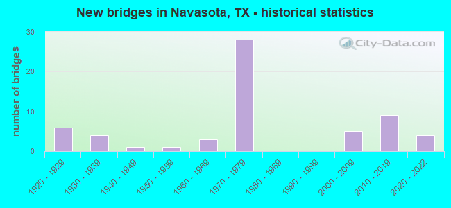
- New bridges - historical statistics
- 61920-1929
- 41930-1939
- 11940-1949
- 11950-1959
- 31960-1969
- 281970-1979
- 52000-2009
- 92010-2019
- 42020-2022
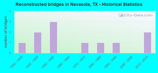
- Reconstructed bridges - Historical Statistics
- 11930-1939
- 21940-1949
- 31950-1959
- 01960-1969
- 11970-1979
- 11980-1989
- 11990-1999
- 02000-2009
- 22010-2019
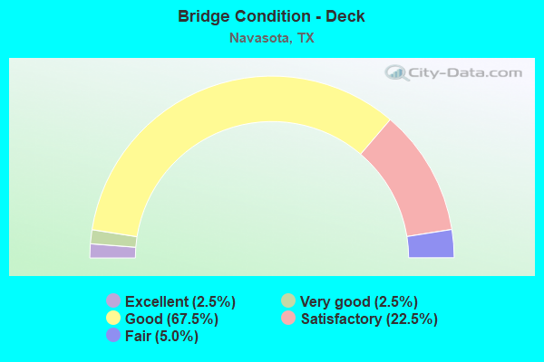
- Bridge Condition - Deck
- 2.5%Excellent
- 2.5%Very good
- 67.5%Good
- 22.5%Satisfactory
- 5.0%Fair
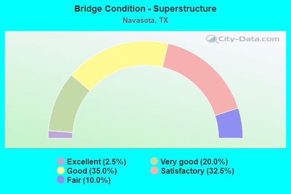
- Bridge Condition - Superstructure
- 2.5%Excellent
- 20.0%Very good
- 35.0%Good
- 32.5%Satisfactory
- 10.0%Fair
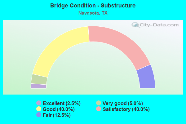
- Bridge Condition - Substructure
- 2.5%Excellent
- 5.0%Very good
- 40.0%Good
- 40.0%Satisfactory
- 12.5%Fair
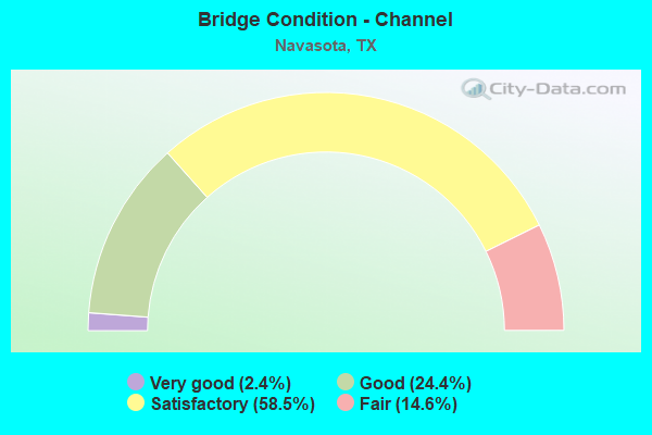
- Bridge Condition - Channel
- 2.4%Very good
- 24.4%Good
- 58.5%Satisfactory
- 14.6%Fair
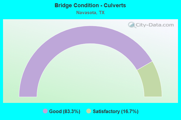
- Bridge Condition - Culverts
- 83.3%Good
- 16.7%Satisfactory
Find on map >> Show street view
Structure Number: 170210005002012, Location: 3.3 MI N OF GRIMES C/L (Lat: 30.454406, Lng: -96.142731), Route carried "on" structure: ServiceState highway 6, Year Built: 1932, Year Reconstructed: 1980, Status: Open, Structure Length: 4.33m (14.21ft), Average Daily Traffic: 12,720 (year 2017), Truck Traffic: 14%, Average Future Daily Traffic: 22,090 (year 2037), Features Intersected: JONES CREEK
Minimum Vertical Clearance: 30+ m (98+ ft), Kilometerpoint: 34.977, Lanes on structure: 2, Owner: State Highway Agency, Approaching Roadway Width: 12.2m (40.0ft), Material/Design: Concrete, Design/Construction: Tee Beam, Number Of Spans In Main Unit: 5, Length of Maximum Span: 8.5m (27.9ft), Curb-To-Curb Width: 19.7m (64.6ft), Out-to-Out Width: 20.2m (66.3ft)
Condition: Deck: Satisfactory, Superstructure: Satisfactory, Substructure: Satisfactory, Channel: Good, Operating Rating: 38.1 metric tons, Method Used To Determine Operating Rating: Load Factor (LF), Inventory Rating: 22.7 metric tons, Method Used To Determine Inventory Rating: Load Factor (LF), Structural Evaluation: Somewhat better than minimum adequacy, Deck Geometry: Superior to present desirable criteria, Waterway Adequacy: Equal to present desirable criteria, Approach Roadway Alignment: Equal to present desirable criteria, Designated Inspection Frequency: Every 24 months, Inspection Date: January 2021, Deck Structure Type: Concrete Cast-file-Place, Wearing Surface/Protective System: Wearing Surface: Bituminous
Find on map >> Show street view
Structure Number: 170210005002014, Location: 1.95 MI SE OF FM 2154 (Lat: 30.418419, Lng: -96.106658), Route carried "on" structure: State highway 6, Year Built: 1930, Year Reconstructed: 1990, Status: Open, Structure Length: 15.51m (50.89ft), Average Daily Traffic: 11,534 (year 2020), Truck Traffic: 14%, Average Future Daily Traffic: 18,890 (year 2033), Design Load: H 15, Features Intersected: NAVASOTA RIVER
Minimum Vertical Clearance: 30+ m (98+ ft), Kilometerpoint: 40.187, Lanes on structure: 2, Base Highway Network: Yes (Inventory Route: SH06SB00, Subroute: 1), Owner: State Highway Agency, Approaching Roadway Width: 12.2m (40.0ft), Material/Design: Steel continuous, Design/Construction: Stringer/Multi-beam, Number Of Spans In Main Unit: 3, Number Of Approach Spans: 11, Length of Maximum Span: 24.4m (80.1ft), Curb-To-Curb Width: 11.4m (37.4ft), Out-to-Out Width: 12.5m (41.0ft)
Condition: Deck: Good, Superstructure: Satisfactory, Substructure: Fair, Channel: Fair, Operating Rating: 43.5 metric tons, Method Used To Determine Operating Rating: Load Factor (LF), Inventory Rating: 25.4 metric tons, Method Used To Determine Inventory Rating: Load Factor (LF), Structural Evaluation: Somewhat better than minimum adequacy, Deck Geometry: Equal to present minimum criteria, Waterway Adequacy: Equal to present desirable criteria, Approach Roadway Alignment: Equal to present desirable criteria, Designated Inspection Frequency: Every 24 months, Inspection Date: January 2021, Deck Structure Type: Concrete Cast-file-Place, Wearing Surface/Protective System: Wearing Surface: Bituminous
Find on map >> Show street view
Structure Number: 170210005002053, Location: 1.95 MI SE OF FM 2154 (Lat: 30.418831, Lng: -96.106108), Route carried "on" structure: State highway 6, Year Built: 1971, Status: Open, Structure Length: 17.68m (58.01ft), Average Daily Traffic: 16,659 (year 2019), Truck Traffic: 14%, Average Future Daily Traffic: 18,890 (year 2033), Design Load: HS 20, Features Intersected: NAVASOTA RIVER
Minimum Vertical Clearance: 30+ m (98+ ft), Kilometerpoint: 40.164, Lanes on structure: 2, Base Highway Network: Yes (Inventory Route: SH06NB00, Subroute: 1), Owner: State Highway Agency, Approaching Roadway Width: 12.2m (40.0ft), Skew: 9 degrees, Material/Design: Prestressed concrete, Design/Construction: Stringer/Multi-beam, Number Of Spans In Main Unit: 1, Number Of Approach Spans: 7, Length of Maximum Span: 27.4m (89.9ft), Curb-To-Curb Width: 12.7m (41.7ft), Out-to-Out Width: 13.5m (44.3ft)
Condition: Deck: Good, Superstructure: Good, Substructure: Fair, Channel: Fair, Operating Rating: 54.4 metric tons, Method Used To Determine Operating Rating: Assigned rating based on Load Factor Design (LFD) reported in metric tons, Inventory Rating: 32.7 metric tons, Method Used To Determine Inventory Rating: Assigned rating based on Load Factor Design (LFD) reported in metric tons, Structural Evaluation: Somewhat better than minimum adequacy, Deck Geometry: Better than present minimum criteria, Waterway Adequacy: Equal to present desirable criteria, Approach Roadway Alignment: Equal to present desirable criteria, Designated Inspection Frequency: Every 24 months, Underwater Inspection Frequency: Every 60 months, Inspection Date: January 2021, Underwater Inspection Date: March 2019, Deck Structure Type: Concrete Cast-file-Place, Wearing Surface/Protective System: Wearing Surface: Bituminous
Find on map >> Show street view
Structure Number: 170210005002165, Location: 6.1 MI S OF FM 159 (Lat: 30.440594, Lng: -96.126978), Route carried "on" structure: State highway 6, Year Built: 2010, Status: Open, Structure Length: 10.06m (33.01ft), Average Daily Traffic: 18,803 (year 2019), Truck Traffic: 15%, Average Future Daily Traffic: 24,490 (year 2037), Design Load: HL 93, Features Intersected: FM 2154
Minimum Vertical Clearance: 30+ m (98+ ft), Kilometerpoint: 39.010, Lanes on structure: 2, Lanes under structure: 2, Owner: State Highway Agency, Approaching Roadway Width: 11.6m (38.1ft), Material/Design: Prestressed concrete, Design/Construction: Stringer/Multi-beam, Number Of Spans In Main Unit: 4, Length of Maximum Span: 27.4m (89.9ft), Curb-To-Curb Width: 11.1m (36.4ft), Out-to-Out Width: 12.2m (40.0ft)
Condition: Deck: Good, Superstructure: Very good, Substructure: Good, Operating Rating: 54.4 metric tons, Method Used To Determine Operating Rating: Assigned ratings based on Load and Resistance Factor Design (LRFD) reported in metric tons, Inventory Rating: 32.7 metric tons, Method Used To Determine Inventory Rating: Assigned ratings based on Load and Resistance Factor Design (LRFD) reported in metric tons, Structural Evaluation: Better than present minimum criteria, Deck Geometry: Equal to present minimum criteria, Underclear: Superior to present desirable criteria, Approach Roadway Alignment: Equal to present desirable criteria, Designated Inspection Frequency: Every 24 months, Inspection Date: January 2021, Deck Structure Type: Concrete Precast Panels
Find on map >> Show street view
Structure Number: 170210005002166, Location: 6.1 MI S OF FM 159 (Lat: 30.440972, Lng: -96.127953), Route carried "on" structure: State highway 6, Year Built: 2010, Status: Open, Structure Length: 10.06m (33.01ft), Average Daily Traffic: 17,706 (year 2019), Truck Traffic: 14%, Average Future Daily Traffic: 17,800 (year 2033), Design Load: HL 93, Features Intersected: FM 2154
Minimum Vertical Clearance: 30+ m (98+ ft), Kilometerpoint: 37.021, Lanes on structure: 2, Lanes under structure: 2, Owner: State Highway Agency, Approaching Roadway Width: 11.6m (38.1ft), Material/Design: Prestressed concrete, Design/Construction: Stringer/Multi-beam, Number Of Spans In Main Unit: 4, Length of Maximum Span: 27.4m (89.9ft), Curb-To-Curb Width: 11.1m (36.4ft), Out-to-Out Width: 12.2m (40.0ft)
Condition: Deck: Good, Superstructure: Very good, Substructure: Good, Operating Rating: 54.4 metric tons, Method Used To Determine Operating Rating: Assigned ratings based on Load and Resistance Factor Design (LRFD) reported in metric tons, Inventory Rating: 32.7 metric tons, Method Used To Determine Inventory Rating: Assigned ratings based on Load and Resistance Factor Design (LRFD) reported in metric tons, Structural Evaluation: Better than present minimum criteria, Deck Geometry: Equal to present minimum criteria, Underclear: Superior to present desirable criteria, Approach Roadway Alignment: Equal to present desirable criteria, Designated Inspection Frequency: Every 24 months, Inspection Date: January 2021, Deck Structure Type: Concrete Precast Panels
Find on map >> Show street view
Structure Number: 170210005002168, Location: 1.4 MI NW OF FM 2154 (Lat: 30.454958, Lng: -96.142225), Route carried "on" structure: State highway 6, Year Built: 2008, Status: Open, Structure Length: 4.57m (14.99ft), Average Daily Traffic: 18,960 (year 2019), Truck Traffic: 14%, Average Future Daily Traffic: 17,800 (year 2033), Design Load: HL 93, Features Intersected: JONES CREEK
Minimum Vertical Clearance: 30+ m (98+ ft), Kilometerpoint: 34.921, Lanes on structure: 2, Owner: State Highway Agency, Approaching Roadway Width: 11.6m (38.1ft), Skew: 4 degrees, Material/Design: Prestressed concrete, Design/Construction: Stringer/Multi-beam, Number Of Spans In Main Unit: 2, Length of Maximum Span: 22.9m (75.1ft), Curb-To-Curb Width: 11.4m (37.4ft), Out-to-Out Width: 12.2m (40.0ft)
Condition: Deck: Good, Superstructure: Very good, Substructure: Good, Channel: Good, Operating Rating: 54.4 metric tons, Method Used To Determine Operating Rating: Assigned ratings based on Load and Resistance Factor Design (LRFD) reported in metric tons, Inventory Rating: 32.7 metric tons, Method Used To Determine Inventory Rating: Assigned ratings based on Load and Resistance Factor Design (LRFD) reported in metric tons, Structural Evaluation: Better than present minimum criteria, Deck Geometry: Equal to present minimum criteria, Waterway Adequacy: Superior to present desirable criteria, Approach Roadway Alignment: Equal to present desirable criteria, Designated Inspection Frequency: Every 24 months, Inspection Date: January 2021, Deck Structure Type: Concrete Precast Panels
Find on map >> Show street view
Structure Number: 170210005002169, Location: 1.4 MI NW OF FM 2154 (Lat: 30.454728, Lng: -96.142497), Route carried "on" structure: State highway 6, Year Built: 2008, Status: Open, Structure Length: 4.57m (14.99ft), Average Daily Traffic: 17,706 (year 2019), Truck Traffic: 14%, Average Future Daily Traffic: 17,800 (year 2033), Design Load: HL 93, Features Intersected: JONES CREEK
Minimum Vertical Clearance: 30+ m (98+ ft), Kilometerpoint: 34.944, Lanes on structure: 2, Owner: State Highway Agency, Approaching Roadway Width: 11.6m (38.1ft), Skew: 4 degrees, Material/Design: Prestressed concrete, Design/Construction: Stringer/Multi-beam, Number Of Spans In Main Unit: 2, Length of Maximum Span: 22.9m (75.1ft), Curb-To-Curb Width: 11.4m (37.4ft), Out-to-Out Width: 12.2m (40.0ft)
Condition: Deck: Good, Superstructure: Very good, Substructure: Good, Channel: Good, Operating Rating: 54.4 metric tons, Method Used To Determine Operating Rating: Assigned ratings based on Load and Resistance Factor Design (LRFD) reported in metric tons, Inventory Rating: 32.7 metric tons, Method Used To Determine Inventory Rating: Assigned ratings based on Load and Resistance Factor Design (LRFD) reported in metric tons, Structural Evaluation: Better than present minimum criteria, Deck Geometry: Equal to present minimum criteria, Waterway Adequacy: Superior to present desirable criteria, Approach Roadway Alignment: Equal to present desirable criteria, Designated Inspection Frequency: Every 24 months, Inspection Date: January 2021, Deck Structure Type: Concrete Precast Panels
Find on map >> Show street view
Structure Number: 170210005002172, Location: 1.4 MI NW OF FM 2154 (Lat: 30.455344, Lng: -96.142192), Route carried "on" structure: ServiceState highway 6, Year Built: 2008, Status: Open, Structure Length: 4.57m (14.99ft), Average Daily Traffic: 100 (year 2013), Truck Traffic: 12%, Average Future Daily Traffic: 140 (year 2033), Design Load: HL 93, Features Intersected: JONES CREEK
Minimum Vertical Clearance: 30+ m (98+ ft), Kilometerpoint: 34.889, Lanes on structure: 2, Owner: State Highway Agency, Approaching Roadway Width: 11.6m (38.1ft), Skew: 4 degrees, Material/Design: Prestressed concrete, Design/Construction: Stringer/Multi-beam, Number Of Spans In Main Unit: 2, Length of Maximum Span: 22.9m (75.1ft), Curb-To-Curb Width: 12.0m (39.4ft), Out-to-Out Width: 12.8m (42.0ft)
Condition: Deck: Good, Superstructure: Very good, Substructure: Good, Channel: Good, Operating Rating: 54.4 metric tons, Method Used To Determine Operating Rating: Assigned ratings based on Load and Resistance Factor Design (LRFD) reported in metric tons, Inventory Rating: 32.7 metric tons, Method Used To Determine Inventory Rating: Assigned ratings based on Load and Resistance Factor Design (LRFD) reported in metric tons, Structural Evaluation: Better than present minimum criteria, Deck Geometry: Better than present minimum criteria, Waterway Adequacy: Superior to present desirable criteria, Approach Roadway Alignment: Equal to present desirable criteria, Designated Inspection Frequency: Every 24 months, Inspection Date: January 2021, Deck Structure Type: Concrete Precast Panels
Find on map >> Show street view
Structure Number: 170210005002185, Location: 1.0 MI SE OF FM 2154 (Lat: 30.427100, Lng: -96.113600), Route carried "on" structure: State highway 6, Year Built: 2008, Status: Open, Structure Length: 0.70m (2.30ft), Average Daily Traffic: 31,703 (year 2020), Truck Traffic: 14%, Average Future Daily Traffic: 28,500 (year 2030), Design Load: HS 20, Features Intersected: DRAW
Minimum Vertical Clearance: 30+ m (98+ ft), Kilometerpoint: 39.208, Lanes on structure: 6, Base Highway Network: Yes (Inventory Route: SH060000, Subroute: 1), Owner: State Highway Agency, Approaching Roadway Width: 34.7m (113.8ft), Skew: 9 degrees, Material/Design: Concrete, Design/Construction: Culvert, Number Of Spans In Main Unit: 2, Length of Maximum Span: 2.4m (7.9ft)
Condition: Channel: Good, Culverts: Good, Operating Rating: 44.4 metric tons, Method Used To Determine Operating Rating: No rating analysis performed, Inventory Rating: 32.7 metric tons, Method Used To Determine Inventory Rating: No rating analysis performed, Structural Evaluation: Better than present minimum criteria, Waterway Adequacy: Equal to present minimum criteria, Approach Roadway Alignment: Equal to present desirable criteria, Designated Inspection Frequency: Every 48 months, Inspection Date: January 2019
Find on map >> Show street view
Structure Number: 17021003150508, Location: 0.58 MI W OF FM 159 (Lat: 30.359433, Lng: -96.154567), Route carried "on" structure: State highway 105, Year Built: 2021, Status: Open, Structure Length: 54.25m (177.99ft), Average Daily Traffic: 7,050 (year 2020), Average Future Daily Traffic: 9,550 (year 2040), Design Load: HL 93, Features Intersected: BRAZOS RIVER
Minimum Vertical Clearance: 30+ m (98+ ft), Kilometerpoint: 32.673, Lanes on structure: 2, Owner: State Highway Agency, Approaching Roadway Width: 13.3m (43.6ft), Material/Design: Steel continuous, Design/Construction: Stringer/Multi-beam, Number Of Spans In Main Unit: 3, Number Of Approach Spans: 7, Length of Maximum Span: 91.4m (299.9ft), Curb-To-Curb Width: 13.3m (43.6ft), Out-to-Out Width: 14.0m (45.9ft)
Condition: Deck: Good, Superstructure: Good, Substructure: Good, Channel: Satisfactory, Operating Rating: 54.4 metric tons, Method Used To Determine Operating Rating: Assigned ratings based on Load and Resistance Factor Design (LRFD) reported in metric tons, Inventory Rating: 32.7 metric tons, Method Used To Determine Inventory Rating: Assigned ratings based on Load and Resistance Factor Design (LRFD) reported in metric tons, Structural Evaluation: Better than present minimum criteria, Deck Geometry: Somewhat better than minimum adequacy, Waterway Adequacy: Better than present minimum criteria, Approach Roadway Alignment: Equal to present desirable criteria, Designated Inspection Frequency: Every 24 months, Inspection Date: November 2021, Deck Structure Type: Concrete Cast-file-Place
Find on map >> Show street view
Structure Number: 170210054005035, Location: 1.5 MI N OF SH 105 (Lat: 30.386225, Lng: -96.153833), Route carried "on" structure: State highway 159, Year Built: 1964, Status: Open, Structure Length: 4.63m (15.19ft), Average Daily Traffic: 472 (year 2020), Truck Traffic: 11%, Average Future Daily Traffic: 730 (year 2033), Design Load: H 15, Features Intersected: BIG SPRING CREEK
Minimum Vertical Clearance: 30+ m (98+ ft), Kilometerpoint: 40.084, Lanes on structure: 2, Owner: State Highway Agency, Approaching Roadway Width: 7.3m (24.0ft), Material/Design: Concrete, Design/Construction: Stringer/Multi-beam, Number Of Spans In Main Unit: 5, Length of Maximum Span: 9.1m (29.9ft), Curb-To-Curb Width: 7.1m (23.3ft), Out-to-Out Width: 7.9m (25.9ft)
Condition: Deck: Good, Superstructure: Good, Substructure: Satisfactory, Channel: Satisfactory, Operating Rating: 49.9 metric tons, Method Used To Determine Operating Rating: Load Factor (LF), Inventory Rating: 29.9 metric tons, Method Used To Determine Inventory Rating: Load Factor (LF), Structural Evaluation: Equal to present minimum criteria, Deck Geometry: Meets minimum limits, Waterway Adequacy: Better than present minimum criteria, Approach Roadway Alignment: Equal to present desirable criteria, Designated Inspection Frequency: Every 24 months, Inspection Date: Febuary 2021, Deck Structure Type: Concrete Cast-file-Place
Find on map >> Show street view
Structure Number: 170940005003017, Location: 2.9 MI S OF SH 105 (Lat: 30.338517, Lng: -96.048583), Route carried "on" structure: State highway 6, Year Built: 1928, Year Reconstructed: 1952, Status: Open, Structure Length: 11.22m (36.81ft), Average Daily Traffic: 12,922 (year 2020), Truck Traffic: 19%, Average Future Daily Traffic: 15,986 (year 2039), Design Load: H 15, Features Intersected: GRASSY CREEK
Minimum Vertical Clearance: 30+ m (98+ ft), Kilometerpoint: 11.124, Lanes on structure: 2, Base Highway Network: Yes, Owner: State Highway Agency, Approaching Roadway Width: 11.0m (36.1ft), Skew: 10 degrees, Material/Design: Concrete, Design/Construction: Tee Beam, Number Of Spans In Main Unit: 15, Length of Maximum Span: 7.6m (24.9ft), Curb-To-Curb Width: 8.9m (29.2ft), Out-to-Out Width: 10.1m (33.1ft)
Condition: Deck: Satisfactory, Superstructure: Fair, Substructure: Fair, Channel: Satisfactory, Operating Rating: 44.4 metric tons, Method Used To Determine Operating Rating: Load Factor (LF), Inventory Rating: 32.7 metric tons, Method Used To Determine Inventory Rating: Load Factor (LF), Structural Evaluation: Somewhat better than minimum adequacy, Deck Geometry: High priority of corrective action, Waterway Adequacy: Equal to present minimum criteria, Approach Roadway Alignment: Equal to present desirable criteria, Length Of Structure Improvement: 11.22m (36.81ft), Designated Inspection Frequency: Every 24 months, Inspection Date: May 2021, Bridge Improvement Cost: $1,319,000, Roadway Improvement Cost: $132,000, Total Project Cost: $1,979,000, Deck Structure Type: Concrete Cast-file-Place, Wearing Surface/Protective System: Wearing Surface: Bituminous
Find on map >> Show street view
Structure Number: 170940005003036, Location: 2.9 MI S OF SH 105 (Lat: 30.338611, Lng: -96.048358), Route carried "on" structure: State highway 6, Year Built: 1964, Status: Open, Structure Length: 12.95m (42.49ft), Average Daily Traffic: 13,326 (year 2020), Truck Traffic: 19%, Average Future Daily Traffic: 15,986 (year 2039), Design Load: H 20, Features Intersected: GRASSY CREEK
Minimum Vertical Clearance: 30+ m (98+ ft), Kilometerpoint: 11.108, Lanes on structure: 2, Base Highway Network: Yes, Owner: State Highway Agency, Approaching Roadway Width: 11.0m (36.1ft), Material/Design: Concrete, Design/Construction: Stringer/Multi-beam, Number Of Spans In Main Unit: 14, Length of Maximum Span: 9.1m (29.9ft), Curb-To-Curb Width: 7.9m (25.9ft), Out-to-Out Width: 10.1m (33.1ft)
Condition: Deck: Good, Superstructure: Good, Substructure: Satisfactory, Channel: Satisfactory, Operating Rating: 54.4 metric tons, Method Used To Determine Operating Rating: Load Factor (LF), Inventory Rating: 32.7 metric tons, Method Used To Determine Inventory Rating: Load Factor (LF), Structural Evaluation: Equal to present minimum criteria, Deck Geometry: High priority of replacement, Waterway Adequacy: Equal to present minimum criteria, Approach Roadway Alignment: Equal to present desirable criteria, Designated Inspection Frequency: Every 24 months, Inspection Date: May 2021, Deck Structure Type: Concrete Cast-file-Place, Wearing Surface/Protective System: Wearing Surface: Bituminous
Find on map >> Show street view
Structure Number: 170940005003047, Location: 0.25 MI SE OF FM 3090 (Lat: 30.405550, Lng: -96.080728), Route carried "on" structure: State highway 6, Year Built: 1970, Year Reconstructed: 2015, Status: Open, Structure Length: 0.67m (2.20ft), Average Daily Traffic: 25,973 (year 2020), Truck Traffic: 18%, Average Future Daily Traffic: 42,281 (year 2039), Design Load: HS 20, Features Intersected: SYLVIA CREEK
Minimum Vertical Clearance: 30+ m (98+ ft), Kilometerpoint: 2.836, Lanes on structure: 10, Base Highway Network: Yes, Owner: State Highway Agency, Approaching Roadway Width: 53.3m (174.9ft), Skew: 20 degrees, Material/Design: Concrete, Design/Construction: Culvert, Number Of Spans In Main Unit: 2, Length of Maximum Span: 3.0m (9.8ft)
Condition: Channel: Satisfactory, Culverts: Satisfactory, Operating Rating: 39.9 metric tons, Method Used To Determine Operating Rating: Load Factor (LF), Inventory Rating: 23.6 metric tons, Method Used To Determine Inventory Rating: Load Factor (LF), Structural Evaluation: Somewhat better than minimum adequacy, Waterway Adequacy: Superior to present desirable criteria, Approach Roadway Alignment: Equal to present desirable criteria, Designated Inspection Frequency: Every 24 months, Inspection Date: May 2021
Find on map >> Show street view
Structure Number: 170940005003048, Location: 0.5 MI SE OF FM 3090 (Lat: 30.403511, Lng: -96.076542), Route carried "on" structure: State highway 6, Year Built: 1970, Year Reconstructed: 2015, Status: Open, Structure Length: 0.88m (2.89ft), Average Daily Traffic: 25,973 (year 2020), Truck Traffic: 16%, Average Future Daily Traffic: 25,390 (year 2033), Design Load: HS 20, Features Intersected: CEDAR CREEK
Minimum Vertical Clearance: 30+ m (98+ ft), Kilometerpoint: 3.249, Lanes on structure: 8, Base Highway Network: Yes, Owner: State Highway Agency, Approaching Roadway Width: 31.4m (103.0ft), Skew: 24 degrees, Material/Design: Concrete, Design/Construction: Culvert, Number Of Spans In Main Unit: 2, Length of Maximum Span: 3.0m (9.8ft)
Condition: Channel: Satisfactory, Culverts: Good, Operating Rating: 39.9 metric tons, Method Used To Determine Operating Rating: Load Factor (LF), Inventory Rating: 23.6 metric tons, Method Used To Determine Inventory Rating: Load Factor (LF), Structural Evaluation: Somewhat better than minimum adequacy, Waterway Adequacy: Superior to present desirable criteria, Approach Roadway Alignment: Equal to present desirable criteria, Designated Inspection Frequency: Every 24 months, Inspection Date: May 2021
Find on map >> Show street view
Structure Number: 170940005003049, Location: 0.15 MI S OF SH 90 (Lat: 30.395794, Lng: -96.069981), Route carried "on" structure: State highway 6, Year Built: 1970, Status: Open, Structure Length: 0.85m (2.79ft), Average Daily Traffic: 27,241 (year 2020), Truck Traffic: 17%, Average Future Daily Traffic: 44,345 (year 2039), Features Intersected: DRAIN
Minimum Vertical Clearance: 30+ m (98+ ft), Kilometerpoint: 4.414, Lanes on structure: 8, Base Highway Network: Yes, Owner: State Highway Agency, Approaching Roadway Width: 42.1m (138.1ft), Skew: 4 degrees, Material/Design: Concrete, Design/Construction: Culvert, Number Of Spans In Main Unit: 3, Length of Maximum Span: 1.8m (5.9ft)
Condition: Channel: Satisfactory, Culverts: Good, Operating Rating: 39.9 metric tons, Method Used To Determine Operating Rating: Load Factor (LF), Inventory Rating: 23.6 metric tons, Method Used To Determine Inventory Rating: Load Factor (LF), Structural Evaluation: Somewhat better than minimum adequacy, Waterway Adequacy: Equal to present desirable criteria, Approach Roadway Alignment: Equal to present desirable criteria, Designated Inspection Frequency: Every 24 months, Inspection Date: May 2021
Find on map >> Show street view
Structure Number: 17094000500305, Location: 0.55 MI S OF SH 90 (Lat: 30.389447, Lng: -96.068675), Route carried "on" structure: State highway 6, Year Built: 1970, Year Reconstructed: 1975, Status: Open, Structure Length: 0.79m (2.59ft), Average Daily Traffic: 27,241 (year 2020), Truck Traffic: 17%, Average Future Daily Traffic: 44,345 (year 2039), Features Intersected: DRAIN
Minimum Vertical Clearance: 30+ m (98+ ft), Kilometerpoint: 5.076, Lanes on structure: 9, Base Highway Network: Yes, Owner: State Highway Agency, Approaching Roadway Width: 52.4m (171.9ft), Skew: 20 degrees, Material/Design: Concrete, Design/Construction: Culvert, Number Of Spans In Main Unit: 4, Length of Maximum Span: 1.8m (5.9ft)
Condition: Channel: Satisfactory, Culverts: Good, Operating Rating: 32.7 metric tons, Method Used To Determine Operating Rating: Field evaluation and documented engineering judgment, Inventory Rating: 24.5 metric tons, Method Used To Determine Inventory Rating: Field evaluation and documented engineering judgment, Structural Evaluation: Equal to present minimum criteria, Waterway Adequacy: Superior to present desirable criteria, Approach Roadway Alignment: Equal to present desirable criteria, Designated Inspection Frequency: Every 24 months, Inspection Date: May 2021
Find on map >> Show street view
Structure Number: 170940005003051, Location: 1.7 MI S OF SH 90 (Lat: 30.372825, Lng: -96.066528), Route carried "on" structure: Ramp State highway 6, Year Built: 1970, Status: Open, Structure Length: 0.70m (2.30ft), Average Daily Traffic: 1,415 (year 2019), Truck Traffic: 11%, Average Future Daily Traffic: 1,783 (year 2039), Design Load: HS 20, Features Intersected: DRAIN
Minimum Vertical Clearance: 30+ m (98+ ft), Kilometerpoint: 6.919, Lanes on structure: 1, Owner: State Highway Agency, Approaching Roadway Width: 7.3m (24.0ft), Skew: 4 degrees, Material/Design: Concrete, Design/Construction: Culvert, Number Of Spans In Main Unit: 3, Length of Maximum Span: 1.5m (4.9ft)
Condition: Channel: Satisfactory, Culverts: Good, Operating Rating: 39.9 metric tons, Method Used To Determine Operating Rating: Load Factor (LF), Inventory Rating: 23.6 metric tons, Method Used To Determine Inventory Rating: Load Factor (LF), Structural Evaluation: Equal to present minimum criteria, Waterway Adequacy: Equal to present minimum criteria, Approach Roadway Alignment: Equal to present desirable criteria, Designated Inspection Frequency: Every 24 months, Inspection Date: May 2021
Find on map >> Show street view
Structure Number: 170940005003052, Location: 1.85 MI S OF SH 90 (Lat: 30.370889, Lng: -96.066625), Route carried "on" structure: State highway 6, Year Built: 1970, Status: Open, Structure Length: 1.31m (4.30ft), Average Daily Traffic: 22,090 (year 2020), Truck Traffic: 19%, Average Future Daily Traffic: 35,960 (year 2039), Design Load: HS 20, Features Intersected: SANDY CREEK
Minimum Vertical Clearance: 30+ m (98+ ft), Kilometerpoint: 7.144, Lanes on structure: 7, Base Highway Network: Yes, Owner: State Highway Agency, Approaching Roadway Width: 37.8m (124.0ft), Skew: 21 degrees, Material/Design: Concrete, Design/Construction: Culvert, Number Of Spans In Main Unit: 4, Length of Maximum Span: 3.0m (9.8ft)
Condition: Channel: Good, Culverts: Good, Operating Rating: 39.9 metric tons, Method Used To Determine Operating Rating: Load Factor (LF), Inventory Rating: 23.6 metric tons, Method Used To Determine Inventory Rating: Load Factor (LF), Structural Evaluation: Somewhat better than minimum adequacy, Waterway Adequacy: Equal to present minimum criteria, Approach Roadway Alignment: Equal to present desirable criteria, Designated Inspection Frequency: Every 24 months, Inspection Date: May 2021
Find on map >> Show street view
Structure Number: 170940005003054, Location: 1.1 MI NW OF FM 3090 (Lat: 30.413703, Lng: -96.101286), Route carried "on" structure: Business State highway 6, Year Built: 1971, Status: Open, Structure Length: 8.99m (29.49ft), Average Daily Traffic: 85 (year 2019), Truck Traffic: 4%, Average Future Daily Traffic: 128 (year 2039), Design Load: HS 20, Features Intersected: SH 6 SB
Minimum Vertical Clearance: 30+ m (98+ ft), Kilometerpoint: 32.815, Lanes on structure: 2, Lanes under structure: 2, Base Highway Network: Yes, Owner: State Highway Agency, Approaching Roadway Width: 12.2m (40.0ft), Skew: 9 degrees, Material/Design: Steel continuous, Design/Construction: Stringer/Multi-beam, Number Of Spans In Main Unit: 1, Number Of Approach Spans: 2, Length of Maximum Span: 41.1m (134.8ft), Curb-To-Curb Width: 12.5m (41.0ft), Out-to-Out Width: 13.5m (44.3ft)
Condition: Deck: Satisfactory, Superstructure: Satisfactory, Substructure: Good, Operating Rating: 58.0 metric tons, Method Used To Determine Operating Rating: Load Factor (LF), Inventory Rating: 34.5 metric tons, Method Used To Determine Inventory Rating: Load Factor (LF), Structural Evaluation: Equal to present minimum criteria, Deck Geometry: Better than present minimum criteria, Underclear: Superior to present desirable criteria, Approach Roadway Alignment: Equal to present desirable criteria, Designated Inspection Frequency: Every 24 months, Inspection Date: May 2021, Deck Structure Type: Concrete Cast-file-Place
Find on map >> Show street view
Structure Number: 170940005003055, Location: 1.05 MI NW OF SH 90 (Lat: 30.407544, Lng: -96.084275), Route carried "on" structure: State highway 3090, Year Built: 1971, Status: Open, Structure Length: 8.84m (29.00ft), Average Daily Traffic: 1,628 (year 2019), Truck Traffic: 7%, Average Future Daily Traffic: 1,954 (year 2039), Design Load: HS 20, Features Intersected: SH 6
Minimum Vertical Clearance: 4.98m (16.34ft), Kilometerpoint: 31.933, Lanes on structure: 2, Lanes under structure: 4, Base Highway Network: Yes, Owner: State Highway Agency, Approaching Roadway Width: 12.8m (42.0ft), Material/Design: Prestressed concrete, Design/Construction: Stringer/Multi-beam, Number Of Spans In Main Unit: 2, Number Of Approach Spans: 2, Length of Maximum Span: 30.5m (100.1ft), Curb-To-Curb Width: 13.1m (43.0ft), Out-to-Out Width: 14.1m (46.3ft)
Condition: Deck: Good, Superstructure: Satisfactory, Substructure: Satisfactory, Operating Rating: 54.4 metric tons, Method Used To Determine Operating Rating: Load Factor (LF), Inventory Rating: 31.7 metric tons, Method Used To Determine Inventory Rating: Load Factor (LF), Structural Evaluation: Equal to present minimum criteria, Deck Geometry: Better than present minimum criteria, Underclear: Somewhat better than minimum adequacy, Approach Roadway Alignment: Equal to present desirable criteria, Designated Inspection Frequency: Every 24 months, Inspection Date: May 2021, Deck Structure Type: Concrete Cast-file-Place
Find on map >> Show street view
Structure Number: 17094000500306, Location: 2.6 MI S OF SH 90 (Lat: 30.361283, Lng: -96.063006), Route carried "on" structure: State highway 6, Year Built: 1971, Status: Open, Structure Length: 21.40m (70.21ft), Average Daily Traffic: 12,843 (year 2019), Truck Traffic: 19%, Average Future Daily Traffic: 17,980 (year 2039), Design Load: HS 20, Features Intersected: BNSF RR & UP RR
Minimum Vertical Clearance: 30+ m (98+ ft), Kilometerpoint: 8.124, Lanes on structure: 2, Base Highway Network: Yes, Owner: State Highway Agency, Approaching Roadway Width: 12.8m (42.0ft), Skew: 6 degrees, Material/Design: Prestressed concrete, Design/Construction: Stringer/Multi-beam, Number Of Spans In Main Unit: 6, Number Of Approach Spans: 2, Length of Maximum Span: 32.0m (105.0ft), Curb-To-Curb Width: 12.9m (42.3ft), Out-to-Out Width: 13.5m (44.3ft)
Condition: Deck: Satisfactory, Superstructure: Good, Substructure: Satisfactory, Operating Rating: 54.4 metric tons, Method Used To Determine Operating Rating: Load Factor (LF), Inventory Rating: 32.7 metric tons, Method Used To Determine Inventory Rating: Load Factor (LF), Structural Evaluation: Equal to present minimum criteria, Deck Geometry: Superior to present desirable criteria, Underclear: Better than present minimum criteria, Approach Roadway Alignment: Equal to present desirable criteria, Designated Inspection Frequency: Every 24 months, Inspection Date: May 2021, Deck Structure Type: Concrete Cast-file-Place
Find on map >> Show street view
Structure Number: 170940005003061, Location: 2.55 MI S OF SH 90 (Lat: 30.361208, Lng: -96.063233), Route carried "on" structure: State highway 6, Year Built: 1971, Status: Open, Structure Length: 20.09m (65.91ft), Average Daily Traffic: 11,119 (year 2020), Truck Traffic: 19%, Average Future Daily Traffic: 17,980 (year 2039), Design Load: HS 20, Features Intersected: BNSF RR & UP RR
Minimum Vertical Clearance: 30+ m (98+ ft), Kilometerpoint: 8.124, Lanes on structure: 2, Base Highway Network: Yes, Owner: State Highway Agency, Approaching Roadway Width: 12.8m (42.0ft), Skew: 6 degrees, Material/Design: Prestressed concrete, Design/Construction: Stringer/Multi-beam, Number Of Spans In Main Unit: 6, Number Of Approach Spans: 2, Length of Maximum Span: 29.9m (98.1ft), Curb-To-Curb Width: 12.9m (42.3ft), Out-to-Out Width: 13.5m (44.3ft)
Condition: Deck: Good, Superstructure: Good, Substructure: Satisfactory, Operating Rating: 54.4 metric tons, Method Used To Determine Operating Rating: Load Factor (LF), Inventory Rating: 23.6 metric tons, Method Used To Determine Inventory Rating: Load Factor (LF), Structural Evaluation: Somewhat better than minimum adequacy, Deck Geometry: Superior to present desirable criteria, Underclear: Better than present minimum criteria, Approach Roadway Alignment: Equal to present desirable criteria, Designated Inspection Frequency: Every 24 months, Inspection Date: May 2021, Deck Structure Type: Concrete Cast-file-Place
Find on map >> Show street view
Structure Number: 170940005003062, Location: 3.9 MI S OF SH 90 (Lat: 30.343850, Lng: -96.051592), Route carried "on" structure: State highway 6, Year Built: 1971, Status: Open, Structure Length: 8.99m (29.49ft), Average Daily Traffic: 26,248 (year 2020), Truck Traffic: 18%, Average Future Daily Traffic: 41,737 (year 2039), Design Load: HS 20, Features Intersected: BS 6 NB
Minimum Vertical Clearance: 5.39m (17.68ft), Kilometerpoint: 10.511, Lanes on structure: 2, Lanes under structure: 2, Base Highway Network: Yes, Owner: State Highway Agency, Approaching Roadway Width: 13.4m (44.0ft), Skew: 9 degrees, Material/Design: Steel continuous, Design/Construction: Stringer/Multi-beam, Number Of Spans In Main Unit: 1, Number Of Approach Spans: 2, Length of Maximum Span: 41.1m (134.8ft), Curb-To-Curb Width: 12.5m (41.0ft), Out-to-Out Width: 13.6m (44.6ft)
Condition: Deck: Fair, Superstructure: Satisfactory, Substructure: Good, Operating Rating: 44.4 metric tons, Method Used To Determine Operating Rating: Assigned ratings based on Allowable Stress Design (ASD) reported in metric tons, Inventory Rating: 32.7 metric tons, Method Used To Determine Inventory Rating: Assigned ratings based on Allowable Stress Design (ASD) reported in metric tons, Structural Evaluation: Equal to present minimum criteria, Deck Geometry: Better than present minimum criteria, Underclear: Superior to present desirable criteria, Approach Roadway Alignment: Equal to present desirable criteria, Designated Inspection Frequency: Every 24 months, Inspection Date: May 2021, Deck Structure Type: Concrete Cast-file-Place
Find on map >> Show street view
Structure Number: 170940005003074, Location: 1.1 MI S OF FM 3090 (Lat: 30.396942, Lng: -96.071369), Route carried "on" structure: State highway 6, Year Built: 1971, Status: Open, Structure Length: 5.79m (19.00ft), Average Daily Traffic: 15,838 (year 2019), Truck Traffic: 17%, Average Future Daily Traffic: 22,173 (year 2039), Design Load: HS 20, Features Intersected: SH 90
Minimum Vertical Clearance: 30+ m (98+ ft), Kilometerpoint: 4.157, Lanes on structure: 2, Lanes under structure: 7, Base Highway Network: Yes, Owner: State Highway Agency, Approaching Roadway Width: 12.8m (42.0ft), Material/Design: Prestressed concrete, Design/Construction: Stringer/Multi-beam, Number Of Spans In Main Unit: 1, Number Of Approach Spans: 2, Length of Maximum Span: 30.5m (100.1ft), Curb-To-Curb Width: 12.8m (42.0ft), Out-to-Out Width: 13.5m (44.3ft)
Condition: Deck: Good, Superstructure: Satisfactory, Substructure: Good, Operating Rating: 54.4 metric tons, Method Used To Determine Operating Rating: Load Factor (LF), Inventory Rating: 31.7 metric tons, Method Used To Determine Inventory Rating: Load Factor (LF), Structural Evaluation: Equal to present minimum criteria, Deck Geometry: Equal to present desirable criteria, Underclear: Equal to present minimum criteria, Approach Roadway Alignment: Equal to present desirable criteria, Designated Inspection Frequency: Every 24 months, Inspection Date: May 2021, Deck Structure Type: Concrete Cast-file-Place
Find on map >> Show street view
Structure Number: 170940005003075, Location: 1.1 MI S OF FM 3090 (Lat: 30.397014, Lng: -96.071167), Route carried "on" structure: State highway 6, Year Built: 1971, Status: Open, Structure Length: 5.79m (19.00ft), Average Daily Traffic: 15,838 (year 2019), Truck Traffic: 17%, Average Future Daily Traffic: 22,173 (year 2039), Design Load: HS 20, Features Intersected: SH 90
Minimum Vertical Clearance: 30+ m (98+ ft), Kilometerpoint: 4.157, Lanes on structure: 2, Lanes under structure: 7, Base Highway Network: Yes, Owner: State Highway Agency, Approaching Roadway Width: 12.8m (42.0ft), Material/Design: Prestressed concrete, Design/Construction: Stringer/Multi-beam, Number Of Spans In Main Unit: 1, Number Of Approach Spans: 2, Length of Maximum Span: 30.5m (100.1ft), Curb-To-Curb Width: 12.8m (42.0ft), Out-to-Out Width: 13.5m (44.3ft)
Condition: Deck: Satisfactory, Superstructure: Good, Substructure: Good, Operating Rating: 54.4 metric tons, Method Used To Determine Operating Rating: Load Factor (LF), Inventory Rating: 31.7 metric tons, Method Used To Determine Inventory Rating: Load Factor (LF), Structural Evaluation: Better than present minimum criteria, Deck Geometry: Equal to present desirable criteria, Underclear: Equal to present minimum criteria, Approach Roadway Alignment: Equal to present desirable criteria, Designated Inspection Frequency: Every 24 months, Inspection Date: May 2021, Deck Structure Type: Concrete Cast-file-Place
Find on map >> Show street view
Structure Number: 170940005003103, Location: 1.45 MI S OF SH 90 (Lat: 30.376489, Lng: -96.067417), Route carried "on" structure: State highway 6, Year Built: 1971, Status: Open, Structure Length: 5.79m (19.00ft), Average Daily Traffic: 16,418 (year 2020), Truck Traffic: 17%, Average Future Daily Traffic: 22,173 (year 2039), Design Load: HS 20, Features Intersected: SH 105
Minimum Vertical Clearance: 30+ m (98+ ft), Kilometerpoint: 6.497, Lanes on structure: 2, Lanes under structure: 4, Base Highway Network: Yes, Owner: State Highway Agency, Approaching Roadway Width: 12.2m (40.0ft), Material/Design: Prestressed concrete, Design/Construction: Stringer/Multi-beam, Number Of Spans In Main Unit: 1, Number Of Approach Spans: 2, Length of Maximum Span: 30.5m (100.1ft), Curb-To-Curb Width: 12.5m (41.0ft), Out-to-Out Width: 13.5m (44.3ft)
Condition: Deck: Good, Superstructure: Good, Substructure: Satisfactory, Operating Rating: 54.4 metric tons, Method Used To Determine Operating Rating: Load Factor (LF), Inventory Rating: 28.1 metric tons, Method Used To Determine Inventory Rating: Load Factor (LF), Structural Evaluation: Equal to present minimum criteria, Deck Geometry: Better than present minimum criteria, Underclear: Meets minimum limits, Approach Roadway Alignment: Equal to present desirable criteria, Designated Inspection Frequency: Every 24 months, Inspection Date: May 2021, Deck Structure Type: Concrete Cast-file-Place
Find on map >> Show street view
Structure Number: 170940005003104, Location: 1.45 MI S OF SH 90 (Lat: 30.376203, Lng: -96.067019), Route carried "on" structure: State highway 6, Year Built: 1971, Status: Open, Structure Length: 5.79m (19.00ft), Average Daily Traffic: 15,838 (year 2019), Truck Traffic: 17%, Average Future Daily Traffic: 22,173 (year 2039), Design Load: HS 20, Features Intersected: SH 105
Minimum Vertical Clearance: 30+ m (98+ ft), Kilometerpoint: 6.497, Lanes on structure: 2, Lanes under structure: 4, Base Highway Network: Yes, Owner: State Highway Agency, Approaching Roadway Width: 12.2m (40.0ft), Material/Design: Prestressed concrete, Design/Construction: Stringer/Multi-beam, Number Of Spans In Main Unit: 1, Number Of Approach Spans: 2, Length of Maximum Span: 30.5m (100.1ft), Curb-To-Curb Width: 12.5m (41.0ft), Out-to-Out Width: 13.5m (44.3ft)
Condition: Deck: Good, Superstructure: Satisfactory, Substructure: Good, Operating Rating: 54.4 metric tons, Method Used To Determine Operating Rating: Load Factor (LF), Inventory Rating: 28.1 metric tons, Method Used To Determine Inventory Rating: Load Factor (LF), Structural Evaluation: Equal to present minimum criteria, Deck Geometry: Better than present minimum criteria, Underclear: Equal to present minimum criteria, Approach Roadway Alignment: Equal to present desirable criteria, Designated Inspection Frequency: Every 24 months, Inspection Date: May 2021, Deck Structure Type: Concrete Cast-file-Place
Find on map >> Show street view
Structure Number: 170940005011015, Location: 0.1 MI N OF SH 105 (Lat: 30.389614, Lng: -96.089428), Route carried "on" structure: State highway 6, Year Built: 1928, Year Reconstructed: 1941, Status: Open, Structure Length: 2.13m (6.99ft), Average Daily Traffic: 9,703 (year 2019), Truck Traffic: 4%, Average Future Daily Traffic: 11,644 (year 2039), Design Load: H 15, Features Intersected: CEDAR CREEK
Minimum Vertical Clearance: 30+ m (98+ ft), Kilometerpoint: 35.747, Lanes on structure: 2, Owner: State Highway Agency, Approaching Roadway Width: 15.2m (49.9ft), Material/Design: Concrete, Design/Construction: Tee Beam, Number Of Spans In Main Unit: 2, Length of Maximum Span: 10.1m (33.1ft), Curb or Sidewalk Widths: Left: 1.2m (3.9ft), Right: 1.2m (3.9ft), Curb-To-Curb Width: 15.2m (49.9ft), Out-to-Out Width: 18.3m (60.0ft)
Condition: Deck: Good, Superstructure: Fair, Substructure: Satisfactory, Channel: Good, Operating Rating: 44.4 metric tons, Method Used To Determine Operating Rating: Load Factor (LF), Inventory Rating: 32.7 metric tons, Method Used To Determine Inventory Rating: Load Factor (LF), Structural Evaluation: Somewhat better than minimum adequacy, Deck Geometry: Superior to present desirable criteria, Waterway Adequacy: Equal to present minimum criteria, Approach Roadway Alignment: Equal to present desirable criteria, Designated Inspection Frequency: Every 24 months, Inspection Date: May 2021, Deck Structure Type: Concrete Cast-file-Place, Wearing Surface/Protective System: Wearing Surface: Bituminous
Find on map >> Show street view
Structure Number: 170940005011016, Location: 2.0 MI S OF SH 105 (Lat: 30.363772, Lng: -96.073053), Route carried "on" structure: State highway 6, Year Built: 1928, Year Reconstructed: 1952, Status: Open, Structure Length: 3.14m (10.30ft), Average Daily Traffic: 2,434 (year 2019), Truck Traffic: 5%, Average Future Daily Traffic: 2,969 (year 2039), Design Load: H 15, Features Intersected: SANDY CREEK
Minimum Vertical Clearance: 30+ m (98+ ft), Kilometerpoint: 39.120, Lanes on structure: 2, Owner: State Highway Agency, Approaching Roadway Width: 11.0m (36.1ft), Material/Design: Concrete, Design/Construction: Slab, Number Of Spans In Main Unit: 5, Length of Maximum Span: 6.1m (20.0ft), Curb-To-Curb Width: 12.2m (40.0ft), Out-to-Out Width: 12.8m (42.0ft)
Condition: Deck: Fair, Superstructure: Fair, Substructure: Satisfactory, Channel: Satisfactory, Operating Rating: 36.3 metric tons, Method Used To Determine Operating Rating: Load Factor (LF), Inventory Rating: 21.8 metric tons, Method Used To Determine Inventory Rating: Load Factor (LF), Structural Evaluation: Somewhat better than minimum adequacy, Deck Geometry: Equal to present minimum criteria, Waterway Adequacy: Equal to present minimum criteria, Approach Roadway Alignment: Equal to present desirable criteria, Designated Inspection Frequency: Every 24 months, Inspection Date: May 2021, Deck Structure Type: Concrete Cast-file-Place, Wearing Surface/Protective System: Wearing Surface: Bituminous
Find on map >> Show street view
Structure Number: 170940031504029, Location: 3.0 MI NE OF SH 6 (Lat: 30.428914, Lng: -96.041800), Route carried "on" structure: State highway 90, Year Built: 1926, Year Reconstructed: 1955, Status: Open, Structure Length: 2.83m (9.28ft), Average Daily Traffic: 6,980 (year 2020), Truck Traffic: 6%, Average Future Daily Traffic: 9,628 (year 2039), Design Load: H 15, Features Intersected: SPRING CREEK
Minimum Vertical Clearance: 30+ m (98+ ft), Kilometerpoint: 51.169, Lanes on structure: 2, Base Highway Network: Yes, Owner: State Highway Agency, Approaching Roadway Width: 12.2m (40.0ft), Material/Design: Concrete, Design/Construction: Tee Beam, Number Of Spans In Main Unit: 3, Length of Maximum Span: 8.8m (28.9ft), Curb-To-Curb Width: 12.0m (39.4ft), Out-to-Out Width: 12.9m (42.3ft)
Condition: Deck: Good, Superstructure: Satisfactory, Substructure: Satisfactory, Channel: Satisfactory, Operating Rating: 44.4 metric tons, Method Used To Determine Operating Rating: Load Factor (LF), Inventory Rating: 32.7 metric tons, Method Used To Determine Inventory Rating: Load Factor (LF), Structural Evaluation: Equal to present minimum criteria, Deck Geometry: Somewhat better than minimum adequacy, Waterway Adequacy: Equal to present minimum criteria, Approach Roadway Alignment: Equal to present desirable criteria, Designated Inspection Frequency: Every 24 months, Inspection Date: May 2021, Deck Structure Type: Concrete Cast-file-Place, Wearing Surface/Protective System: Wearing Surface: Bituminous
Find on map >> Show street view
Structure Number: 170940031504081, Location: 4.75 MI SW OF SH 6 (Lat: 30.364608, Lng: -96.141442), Route carried "on" structure: State highway 105, Year Built: 2021, Status: Open, Structure Length: 19.81m (64.99ft), Average Daily Traffic: 7,050 (year 2020), Average Future Daily Traffic: 9,550 (year 2040), Design Load: HL 93, Features Intersected: NAVASOTA RIVER
Minimum Vertical Clearance: 30+ m (98+ ft), Kilometerpoint: 34.018, Lanes on structure: 2, Owner: State Highway Agency, Approaching Roadway Width: 13.3m (43.6ft), Skew: 3 degrees, Material/Design: Prestressed concrete, Design/Construction: Stringer/Multi-beam, Number Of Spans In Main Unit: 5, Length of Maximum Span: 39.6m (129.9ft), Curb-To-Curb Width: 13.4m (44.0ft), Out-to-Out Width: 14.0m (45.9ft)
Condition: Deck: Good, Superstructure: Good, Substructure: Good, Channel: Satisfactory, Operating Rating: 54.4 metric tons, Method Used To Determine Operating Rating: Assigned ratings based on Load and Resistance Factor Design (LRFD) reported in metric tons, Inventory Rating: 32.7 metric tons, Method Used To Determine Inventory Rating: Assigned ratings based on Load and Resistance Factor Design (LRFD) reported in metric tons, Structural Evaluation: Better than present minimum criteria, Deck Geometry: Equal to present minimum criteria, Waterway Adequacy: Equal to present desirable criteria, Approach Roadway Alignment: Equal to present desirable criteria, Designated Inspection Frequency: Every 24 months, Inspection Date: November 2021, Deck Structure Type: Concrete Cast-file-Place
Find on map >> Show street view
Structure Number: 170940031504084, Location: 2.32 MI NE OF SH 6 (Lat: 30.420047, Lng: -96.046350), Route carried "on" structure: State highway 90, Year Built: 1926, Year Reconstructed: 1955, Status: Open, Structure Length: 0.67m (2.20ft), Average Daily Traffic: 11,877 (year 2020), Truck Traffic: 6%, Average Future Daily Traffic: 9,628 (year 2039), Features Intersected: TERRELL'S BRANCH
Minimum Vertical Clearance: 30+ m (98+ ft), Kilometerpoint: 52.114, Lanes on structure: 2, Base Highway Network: Yes, Owner: State Highway Agency, Approaching Roadway Width: 12.2m (40.0ft), Material/Design: Concrete, Design/Construction: Slab, Number Of Spans In Main Unit: 1, Length of Maximum Span: 6.7m (22.0ft), Curb-To-Curb Width: 12.1m (39.7ft), Out-to-Out Width: 12.9m (42.3ft)
Condition: Deck: Good, Superstructure: Satisfactory, Substructure: Satisfactory, Channel: Satisfactory, Operating Rating: 38.1 metric tons, Method Used To Determine Operating Rating: Load Factor (LF), Inventory Rating: 22.7 metric tons, Method Used To Determine Inventory Rating: Load Factor (LF), Structural Evaluation: Somewhat better than minimum adequacy, Deck Geometry: Somewhat better than minimum adequacy, Waterway Adequacy: Better than present minimum criteria, Approach Roadway Alignment: Equal to present desirable criteria, Designated Inspection Frequency: Every 24 months, Inspection Date: May 2021, Deck Structure Type: Concrete Cast-file-Place, Wearing Surface/Protective System: Wearing Surface: Bituminous
Find on map >> Show street view
Structure Number: 170940033801105, Location: 0.9 MI E OF SH 6 (Lat: 30.375147, Lng: -96.052217), Route carried "on" structure: State highway 105, Year Built: 1978, Status: Open, Structure Length: 1.16m (3.81ft), Average Daily Traffic: 10,088 (year 2020), Truck Traffic: 13%, Average Future Daily Traffic: 13,016 (year 2039), Design Load: HS 20, Features Intersected: SANDY CREEK
Minimum Vertical Clearance: 30+ m (98+ ft), Kilometerpoint: 2.840, Lanes on structure: 2, Base Highway Network: Yes, Owner: State Highway Agency, Approaching Roadway Width: 14.5m (47.6ft), Skew: 3 degrees, Material/Design: Concrete, Design/Construction: Culvert, Number Of Spans In Main Unit: 3, Length of Maximum Span: 3.0m (9.8ft), Curb-To-Curb Width: 14.5m (47.6ft), Out-to-Out Width: 26.6m (87.3ft)
Condition: Channel: Fair, Culverts: Good, Operating Rating: 39.9 metric tons, Method Used To Determine Operating Rating: Load Factor (LF), Inventory Rating: 23.6 metric tons, Method Used To Determine Inventory Rating: Load Factor (LF), Structural Evaluation: Somewhat better than minimum adequacy, Deck Geometry: Superior to present desirable criteria, Waterway Adequacy: Equal to present minimum criteria, Approach Roadway Alignment: Equal to present desirable criteria, Designated Inspection Frequency: Every 24 months, Inspection Date: May 2021, Wearing Surface/Protective System: Wearing Surface: Bituminous
Find on map >> Show street view
Structure Number: 170940033801106, Location: 3.5 MI E OF SH 6 (Lat: 30.362658, Lng: -96.011797), Route carried "on" structure: State highway 105, Year Built: 1978, Status: Open, Structure Length: 1.22m (4.00ft), Average Daily Traffic: 8,565 (year 2020), Truck Traffic: 15%, Average Future Daily Traffic: 11,052 (year 2039), Design Load: HS 20, Features Intersected: LITTLE GRASSY CREEK
Minimum Vertical Clearance: 30+ m (98+ ft), Kilometerpoint: 7.004, Lanes on structure: 2, Base Highway Network: Yes, Owner: State Highway Agency, Approaching Roadway Width: 12.2m (40.0ft), Skew: 1 degrees, Material/Design: Concrete, Design/Construction: Culvert, Number Of Spans In Main Unit: 4, Length of Maximum Span: 2.7m (8.9ft), Curb-To-Curb Width: 12.2m (40.0ft), Out-to-Out Width: 44.4m (145.7ft)
Condition: Channel: Satisfactory, Culverts: Good, Operating Rating: 39.9 metric tons, Method Used To Determine Operating Rating: Load Factor (LF), Inventory Rating: 23.6 metric tons, Method Used To Determine Inventory Rating: Load Factor (LF), Structural Evaluation: Somewhat better than minimum adequacy, Deck Geometry: Somewhat better than minimum adequacy, Waterway Adequacy: Equal to present minimum criteria, Approach Roadway Alignment: Equal to present desirable criteria, Designated Inspection Frequency: Every 24 months, Inspection Date: May 2021
Find on map >> Show street view
Structure Number: 170940064305066, Location: 0.42 MI N OF FM 3455 (Lat: 30.431350, Lng: -96.062533), Route carried "on" structure: State highway 3090, Year Built: 2017, Status: Open, Structure Length: 1.52m (4.99ft), Average Daily Traffic: 1,628 (year 2019), Truck Traffic: 7%, Average Future Daily Traffic: 1,954 (year 2039), Design Load: HL 93, Features Intersected: SPRING CREEK
Minimum Vertical Clearance: 30+ m (98+ ft), Kilometerpoint: 28.221, Lanes on structure: 2, Owner: State Highway Agency, Approaching Roadway Width: 7.6m (24.9ft), Material/Design: Prestressed concrete, Design/Construction: Stringer/Multi-beam, Number Of Spans In Main Unit: 1, Length of Maximum Span: 15.2m (49.9ft), Curb-To-Curb Width: 9.6m (31.5ft), Out-to-Out Width: 10.4m (34.1ft)
Condition: Deck: Good, Superstructure: Very good, Substructure: Very good, Channel: Satisfactory, Operating Rating: 54.4 metric tons, Method Used To Determine Operating Rating: Assigned ratings based on Load and Resistance Factor Design (LRFD) reported in metric tons, Inventory Rating: 32.7 metric tons, Method Used To Determine Inventory Rating: Assigned ratings based on Load and Resistance Factor Design (LRFD) reported in metric tons, Structural Evaluation: Equal to present desirable criteria, Deck Geometry: Somewhat better than minimum adequacy, Waterway Adequacy: Equal to present minimum criteria, Approach Roadway Alignment: Equal to present desirable criteria, Designated Inspection Frequency: Every 24 months, Inspection Date: May 2021, Deck Structure Type: Concrete Cast-file-Place
Find on map >> Show street view
Structure Number: 170940064305067, Location: 0.72 MI N OF FM 3455 (Lat: 30.435989, Lng: -96.062872), Route carried "on" structure: State highway 3090, Year Built: 2017, Status: Open, Structure Length: 5.94m (19.49ft), Average Daily Traffic: 1,628 (year 2019), Truck Traffic: 7%, Average Future Daily Traffic: 1,954 (year 2039), Design Load: HL 93, Features Intersected: SPRING/HOLLAND CREEK REL
Minimum Vertical Clearance: 30+ m (98+ ft), Kilometerpoint: 27.771, Lanes on structure: 2, Owner: State Highway Agency, Approaching Roadway Width: 7.6m (24.9ft), Material/Design: Prestressed concrete, Design/Construction: Stringer/Multi-beam, Number Of Spans In Main Unit: 3, Length of Maximum Span: 19.8m (65.0ft), Curb-To-Curb Width: 9.6m (31.5ft), Out-to-Out Width: 10.4m (34.1ft)
Condition: Deck: Good, Superstructure: Very good, Substructure: Very good, Channel: Satisfactory, Operating Rating: 54.4 metric tons, Method Used To Determine Operating Rating: Assigned ratings based on Load and Resistance Factor Design (LRFD) reported in metric tons, Inventory Rating: 32.7 metric tons, Method Used To Determine Inventory Rating: Assigned ratings based on Load and Resistance Factor Design (LRFD) reported in metric tons, Structural Evaluation: Equal to present desirable criteria, Deck Geometry: Somewhat better than minimum adequacy, Waterway Adequacy: Equal to present minimum criteria, Approach Roadway Alignment: Equal to present desirable criteria, Designated Inspection Frequency: Every 24 months, Inspection Date: May 2021, Deck Structure Type: Concrete Cast-file-Place
Find on map >> Show street view
Structure Number: 170940064305068, Location: 0.88 MI N OF FM 3455 (Lat: 30.438275, Lng: -96.062717), Route carried "on" structure: State highway 3090, Year Built: 2017, Status: Open, Structure Length: 5.64m (18.50ft), Average Daily Traffic: 1,628 (year 2019), Truck Traffic: 7%, Average Future Daily Traffic: 1,954 (year 2039), Design Load: HL 93, Features Intersected: HOLLAND CREEK
Minimum Vertical Clearance: 30+ m (98+ ft), Kilometerpoint: 27.402, Lanes on structure: 2, Owner: State Highway Agency, Approaching Roadway Width: 7.6m (24.9ft), Material/Design: Prestressed concrete, Design/Construction: Stringer/Multi-beam, Number Of Spans In Main Unit: 1, Number Of Approach Spans: 3, Length of Maximum Span: 19.8m (65.0ft), Curb-To-Curb Width: 9.6m (31.5ft), Out-to-Out Width: 10.4m (34.1ft)
Condition: Deck: Good, Superstructure: Very good, Substructure: Satisfactory, Channel: Fair, Operating Rating: 54.4 metric tons, Method Used To Determine Operating Rating: Assigned ratings based on Load and Resistance Factor Design (LRFD) reported in metric tons, Inventory Rating: 32.7 metric tons, Method Used To Determine Inventory Rating: Assigned ratings based on Load and Resistance Factor Design (LRFD) reported in metric tons, Structural Evaluation: Equal to present minimum criteria, Deck Geometry: Somewhat better than minimum adequacy, Waterway Adequacy: Equal to present minimum criteria, Approach Roadway Alignment: Equal to present desirable criteria, Designated Inspection Frequency: Every 24 months, Inspection Date: May 2021, Deck Structure Type: Concrete Cast-file-Place
Find on map >> Show street view
Structure Number: 170940AA0107002, Location: 0.15 MI S OF BS 6 (Lat: 30.362258, Lng: -96.073525), Route carried "on" structure: County highway 107, Year Built: 2011, Status: Open, Structure Length: 1.31m (4.30ft), Average Daily Traffic: 200 (year 2011), Average Future Daily Traffic: 250 (year 2031), Design Load: HS 20, Features Intersected: SANDY CREEK, Facility Carried by Structure: CR 420
Minimum Vertical Clearance: 30+ m (98+ ft), Kilometerpoint: 0.238, Lanes on structure: 2, Owner: County Highway Agency, Approaching Roadway Width: 7.3m (24.0ft), Material/Design: Concrete, Design/Construction: Culvert, Number Of Spans In Main Unit: 4, Length of Maximum Span: 3.0m (9.8ft)
Condition: Channel: Satisfactory, Culverts: Good, Operating Rating: 54.4 metric tons, Method Used To Determine Operating Rating: Assigned rating based on Load Factor Design (LFD) reported in metric tons, Inventory Rating: 32.7 metric tons, Method Used To Determine Inventory Rating: Assigned rating based on Load Factor Design (LFD) reported in metric tons, Structural Evaluation: Better than present minimum criteria, Waterway Adequacy: Equal to present desirable criteria, Approach Roadway Alignment: Equal to present desirable criteria, Designated Inspection Frequency: Every 24 months, Inspection Date: December 2021
Find on map >> Show street view
Structure Number: 170940AA0127001, Location: 0.6 MI E OF SH 90 (Lat: 30.428197, Lng: -96.033225), Route carried "on" structure: County highway 409, Year Built: 1970, Status: Open, Structure Length: 1.22m (4.00ft), Average Daily Traffic: 140 (year 2010), Average Future Daily Traffic: 150 (year 2028), Features Intersected: SPRING CREEK
Minimum Vertical Clearance: 30+ m (98+ ft), Kilometerpoint: 0.010, Lanes on structure: 1, Owner: County Highway Agency, Approaching Roadway Width: 6.1m (20.0ft), Material/Design: Steel, Design/Construction: Stringer/Multi-beam, Number Of Spans In Main Unit: 1, Length of Maximum Span: 11.9m (39.0ft), Curb-To-Curb Width: 5.5m (18.0ft), Out-to-Out Width: 5.5m (18.0ft)
Condition: Deck: Good, Superstructure: Satisfactory, Substructure: Good, Channel: Satisfactory, Operating Rating: 43.5 metric tons, Method Used To Determine Operating Rating: Allowable Stress (AS), Inventory Rating: 30.8 metric tons, Method Used To Determine Inventory Rating: Allowable Stress (AS), Structural Evaluation: Equal to present minimum criteria, Deck Geometry: High priority of corrective action, Waterway Adequacy: Better than present minimum criteria, Approach Roadway Alignment: Equal to present minimum criteria, Designated Inspection Frequency: Every 24 months, Inspection Date: December 2021, Deck Structure Type: Wood or Timber, Wearing Surface/Protective System: Wearing Surface: Wood or Timber
Find on map >> Show street view
Structure Number: 170940AA0131003, Location: 1.3 MI N OF FM 3090 (Lat: 30.437161, Lng: -96.081425), Route carried "on" structure: County highway 403, Year Built: 2011, Status: Open, Structure Length: 4.88m (16.01ft), Average Daily Traffic: 150 (year 2011), Average Future Daily Traffic: 200 (year 2031), Design Load: HL 93, Features Intersected: HOLLAND CREEK
Minimum Vertical Clearance: 30+ m (98+ ft), Kilometerpoint: 2.089, Lanes on structure: 2, Owner: County Highway Agency, Approaching Roadway Width: 7.9m (25.9ft), Material/Design: Concrete, Design/Construction: Stringer/Multi-beam, Number Of Spans In Main Unit: 4, Length of Maximum Span: 12.2m (40.0ft), Curb-To-Curb Width: 6.9m (22.6ft), Out-to-Out Width: 7.9m (25.9ft)
Condition: Deck: Good, Superstructure: Good, Substructure: Fair, Channel: Fair, Operating Rating: 54.4 metric tons, Method Used To Determine Operating Rating: Assigned ratings based on Load and Resistance Factor Design (LRFD) reported in metric tons, Inventory Rating: 32.7 metric tons, Method Used To Determine Inventory Rating: Assigned ratings based on Load and Resistance Factor Design (LRFD) reported in metric tons, Structural Evaluation: Somewhat better than minimum adequacy, Deck Geometry: Meets minimum limits, Waterway Adequacy: Better than present minimum criteria, Approach Roadway Alignment: Equal to present desirable criteria, Designated Inspection Frequency: Every 24 months, Inspection Date: December 2021, Deck Structure Type: Concrete Cast-file-Place
Find on map >> Show street view
Structure Number: 170940AA0202004, Location: 1.3 MI SW OF FM 1774 (Lat: 30.324483, Lng: -95.875828), Route carried "on" structure: County highway 202, Year Built: 2020, Status: Open, Structure Length: 2.29m (7.51ft), Average Daily Traffic: 100 (year 2020), Truck Traffic: 2%, Average Future Daily Traffic: 200 (year 2035), Design Load: HL 93, Features Intersected: HURRICANE CREEK
Minimum Vertical Clearance: 30+ m (98+ ft), Kilometerpoint: 0.000, Lanes on structure: 2, Owner: County Highway Agency, Approaching Roadway Width: 6.1m (20.0ft), Material/Design: Prestressed concrete, Design/Construction: Stringer/Multi-beam, Number Of Spans In Main Unit: 1, Length of Maximum Span: 22.9m (75.1ft), Curb-To-Curb Width: 7.3m (24.0ft), Out-to-Out Width: 7.9m (25.9ft)
Condition: Deck: Excellent, Superstructure: Excellent, Substructure: Excellent, Channel: Very good, Operating Rating: 54.4 metric tons, Method Used To Determine Operating Rating: Assigned ratings based on Load and Resistance Factor Design (LRFD) reported in metric tons, Inventory Rating: 32.7 metric tons, Method Used To Determine Inventory Rating: Assigned ratings based on Load and Resistance Factor Design (LRFD) reported in metric tons, Structural Evaluation: Superior to present desirable criteria, Deck Geometry: Equal to present minimum criteria, Waterway Adequacy: Superior to present desirable criteria, Approach Roadway Alignment: Equal to present desirable criteria, Designated Inspection Frequency: Every 24 months, Inspection Date: August 2020, Deck Structure Type: Concrete Precast Panels
Find on map >> Show street view
Structure Number: 170940AA0417001, Location: 0.2 MI W OF SH 105 (Lat: 30.361514, Lng: -96.012578), Route carried "on" structure: County highway 417, Year Built: 1960, Status: Posted for load, Structure Length: 3.51m (11.52ft), Average Daily Traffic: 100 (year 2016), Truck Traffic: 2%, Average Future Daily Traffic: 200 (year 2035), Features Intersected: LITTLE GRASSY CREEK
Minimum Vertical Clearance: 30+ m (98+ ft), Kilometerpoint: 1.127, Lanes on structure: 2, Owner: County Highway Agency, Approaching Roadway Width: 6.1m (20.0ft), Material/Design: Steel, Design/Construction: Stringer/Multi-beam, Number Of Spans In Main Unit: 4, Length of Maximum Span: 8.8m (28.9ft), Curb-To-Curb Width: 7.3m (24.0ft), Out-to-Out Width: 7.7m (25.3ft)
Condition: Deck: Good, Superstructure: Good, Substructure: Fair, Channel: Satisfactory, Operating Rating: 19.0 metric tons, Method Used To Determine Operating Rating: Allowable Stress (AS), Inventory Rating: 10.9 metric tons, Method Used To Determine Inventory Rating: Allowable Stress (AS), Structural Evaluation: Meets minimum limits, Deck Geometry: Equal to present minimum criteria, Waterway Adequacy: Better than present minimum criteria, Approach Roadway Alignment: Equal to present desirable criteria, Bridge Posting: Required (Relationship of Operating Rating to Maximum Legal Load: > 39.9% below), Designated Inspection Frequency: Every 24 months, Inspection Date: December 2021, Deck Structure Type: Concrete Cast-file-Place, Wearing Surface/Protective System: Wearing Surface: Bituminous