Bridge Statistics for New Baden, Illinois (IL)
Condition, Traffic, Stress, Structural Evaluation, Project Costs
- National Bridge Inventory (NBI) Statistics
- 30Number of bridges
- 187ft / 56.7mTotal length
- $70,000Total costs
- 258,175Total average daily traffic
- 72,966Total average daily truck traffic
- National Bridge Inventory (NBI) Registered Bridges for New Baden
- No street view available for this location
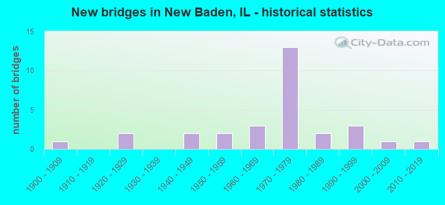
- New bridges - historical statistics
- 11900-1909
- 21920-1929
- 21940-1949
- 21950-1959
- 31960-1969
- 131970-1979
- 21980-1989
- 31990-1999
- 12000-2009
- 12010-2019
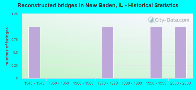
- Reconstructed bridges - Historical Statistics
- 11940-1949
- 01950-1959
- 01960-1969
- 11970-1979
- 01980-1989
- 11990-1999
- 12000-2009

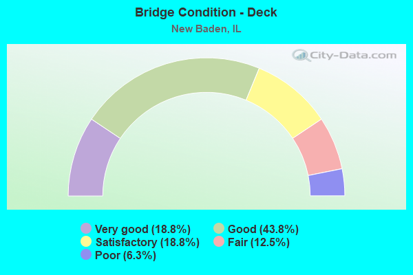
- Bridge Condition - Deck
- 18.8%Very good
- 43.8%Good
- 18.8%Satisfactory
- 12.5%Fair
- 6.3%Poor
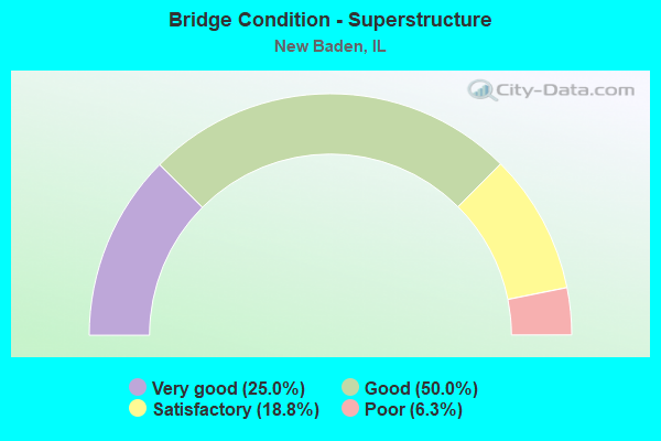
- Bridge Condition - Superstructure
- 25.0%Very good
- 50.0%Good
- 18.8%Satisfactory
- 6.3%Poor
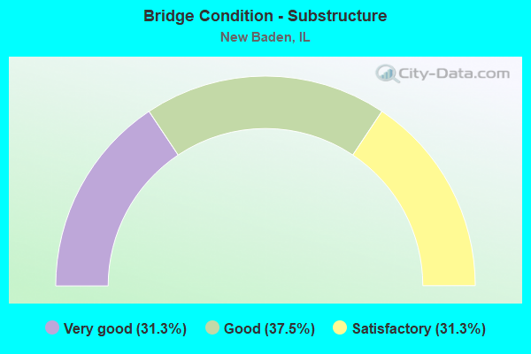
- Bridge Condition - Substructure
- 31.3%Very good
- 37.5%Good
- 31.3%Satisfactory
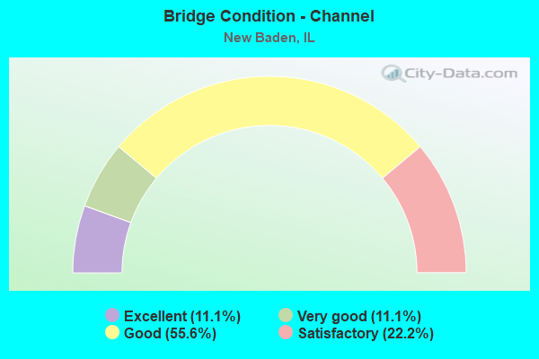
- Bridge Condition - Channel
- 11.1%Excellent
- 11.1%Very good
- 55.6%Good
- 22.2%Satisfactory
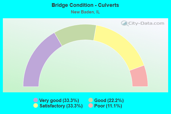
- Bridge Condition - Culverts
- 33.3%Very good
- 22.2%Good
- 33.3%Satisfactory
- 11.1%Poor
Find on map >> Show street view
Structure Number: 140003, Location: W CL NEW MEMPHIS (Lat: 38.477653, Lng: -89.682650), Route carried "on" structure: State highway 160, Year Built: 1922, Year Reconstructed: 1997, Status: Posted for load, Structure Length: 2.16m (7.09ft), Average Daily Traffic: 2,050 (year 2021), Truck Traffic: 7%, Average Future Daily Traffic: 2,070 (year 2032), Design Load: HS 20, Features Intersected: QUEENS LAKE, Facility Carried by Structure: ILL 177
Minimum Vertical Clearance: 30+ m (98+ ft), Kilometerpoint: 24.815, Lanes on structure: 2, Base Highway Network: Yes, Owner: State Highway Agency, Approaching Roadway Width: 7.3m (24.0ft), Skew: 3 degrees, Material/Design: Concrete continuous, Design/Construction: Slab, Number Of Spans In Main Unit: 3, Length of Maximum Span: 7.9m (25.9ft), Curb-To-Curb Width: 8.5m (27.9ft), Out-to-Out Width: 10.5m (34.4ft)
Condition: Deck: Poor, Superstructure: Poor, Substructure: Satisfactory, Channel: Good, Operating Rating: 44.4 metric tons, Method Used To Determine Operating Rating: Load Factor (LF) rating reported by rating factor (RF) method using MS18 loading, Inventory Rating: 26.6 metric tons, Method Used To Determine Inventory Rating: Load Factor (LF) rating reported by rating factor (RF) method using MS18 loading, Structural Evaluation: Meets minimum limits, Deck Geometry: Meets minimum limits, Waterway Adequacy: Equal to present minimum criteria, Approach Roadway Alignment: Equal to present desirable criteria, Bridge Posting: Required (Relationship of Operating Rating to Maximum Legal Load: 20.0 - 29.9% below), Designated Inspection Frequency: Every 12 months, Inspection Date: July 2021, Deck Structure Type: Concrete Cast-file-Place
Find on map >> Show street view
Structure Number: 140036, Location: 3 MI W DAMIANSVILLE (Lat: 38.516500, Lng: -89.686392), Route carried "on" structure: State highway 160, Year Built: 1970, Status: Open, Structure Length: 5.52m (18.11ft), Average Daily Traffic: 2,650 (year 2021), Truck Traffic: 7%, Average Future Daily Traffic: 2,588 (year 2032), Design Load: HS 20, Features Intersected: FAI 64
Minimum Vertical Clearance: 30+ m (98+ ft), Kilometerpoint: 29.338, Lanes on structure: 2, Lanes under structure: 4, Base Highway Network: Yes, Owner: State Highway Agency, Approaching Roadway Width: 11.0m (36.1ft), Material/Design: Steel continuous, Design/Construction: Stringer/Multi-beam, Number Of Spans In Main Unit: 2, Number Of Approach Spans: 2, Length of Maximum Span: 27.4m (89.9ft), Curb-To-Curb Width: 10.5m (34.4ft), Out-to-Out Width: 11.6m (38.1ft)
Condition: Deck: Good, Superstructure: Good, Substructure: Good, Operating Rating: 59.6 metric tons, Method Used To Determine Operating Rating: Allowable Stress (AS) rating reported by rating factor (RF) method using MS18 loading, Inventory Rating: 33.7 metric tons, Method Used To Determine Inventory Rating: Allowable Stress (AS) rating reported by rating factor (RF) method using MS18 loading, Structural Evaluation: Better than present minimum criteria, Deck Geometry: Somewhat better than minimum adequacy, Underclear: Somewhat better than minimum adequacy, Approach Roadway Alignment: Equal to present minimum criteria, Designated Inspection Frequency: Every 24 months, Inspection Date: Febuary 2021, Deck Structure Type: Concrete Cast-file-Place, Wearing Surface/Protective System: Wearing Surface: Other
Find on map >> Show street view
Structure Number: 140038, Location: ST CLAIR CO LINE (Lat: 38.519039, Lng: -89.705058), Route carried "on" structure: County highway , Year Built: 1972, Year Reconstructed: 2008, Status: Open, Structure Length: 5.91m (19.39ft), Average Daily Traffic: 625 (year 2020), Truck Traffic: 10%, Average Future Daily Traffic: 311 (year 2032), Design Load: HS 15, Features Intersected: FAI 64, Facility Carried by Structure: County Line Rd-CH
Minimum Vertical Clearance: 30+ m (98+ ft), Kilometerpoint: 1.786, Lanes on structure: 2, Lanes under structure: 4, Owner: State Highway Agency, Approaching Roadway Width: 9.1m (29.9ft), Material/Design: Steel continuous, Design/Construction: Stringer/Multi-beam, Number Of Spans In Main Unit: 2, Number Of Approach Spans: 2, Length of Maximum Span: 29.3m (96.1ft), Curb-To-Curb Width: 8.7m (28.5ft), Out-to-Out Width: 9.8m (32.2ft)
Condition: Deck: Good, Superstructure: Very good, Substructure: Good, Operating Rating: 56.7 metric tons, Method Used To Determine Operating Rating: Load Factor (LF) rating reported by rating factor (RF) method using MS18 loading, Inventory Rating: 34.0 metric tons, Method Used To Determine Inventory Rating: Load Factor (LF) rating reported by rating factor (RF) method using MS18 loading, Structural Evaluation: Better than present minimum criteria, Deck Geometry: Somewhat better than minimum adequacy, Underclear: Somewhat better than minimum adequacy, Approach Roadway Alignment: Equal to present desirable criteria, Designated Inspection Frequency: Every 24 months, Inspection Date: Febuary 2021, Deck Structure Type: Concrete Cast-file-Place, Wearing Surface/Protective System: Wearing Surface: Other
Find on map >> Show street view
Structure Number: 140079, Location: 2.2 M S TRENTON US50 (Lat: 38.571592, Lng: -89.686444), Route carried "on" structure: State highway 160, Year Built: 2012, Status: Open, Structure Length: 2.35m (7.71ft), Average Daily Traffic: 4,750 (year 2021), Truck Traffic: 7%, Average Future Daily Traffic: 4,037 (year 2032), Design Load: HS 25 or greater, Features Intersected: BRANCH LAKE CREEK
Minimum Vertical Clearance: 30+ m (98+ ft), Kilometerpoint: 35.421, Lanes on structure: 2, Base Highway Network: Yes, Owner: State Highway Agency, Approaching Roadway Width: 11.0m (36.1ft), Material/Design: Steel, Design/Construction: Stringer/Multi-beam, Number Of Spans In Main Unit: 1, Length of Maximum Span: 22.7m (74.5ft), Curb-To-Curb Width: 11.0m (36.1ft), Out-to-Out Width: 11.9m (39.0ft)
Condition: Deck: Very good, Superstructure: Very good, Substructure: Very good, Channel: Excellent, Operating Rating: 71.9 metric tons, Method Used To Determine Operating Rating: Load and Resistance Factor Rating (LRFR) rating reported by rating factor(RF) method using HL-93 loadings, Inventory Rating: 55.4 metric tons, Method Used To Determine Inventory Rating: Load and Resistance Factor Rating (LRFR) rating reported by rating factor(RF) method using HL-93 loadings, Structural Evaluation: Equal to present desirable criteria, Deck Geometry: Somewhat better than minimum adequacy, Waterway Adequacy: Equal to present desirable criteria, Approach Roadway Alignment: Equal to present desirable criteria, Designated Inspection Frequency: Every 48 months, Inspection Date: January 2021, Deck Structure Type: Concrete Cast-file-Place, Wearing Surface/Protective System: Deck Protection: Epoxy Coated Reinforcing
Find on map >> Show street view
Structure Number: 142003, Location: .5 MI N NEW BADEN (Lat: 38.546789, Lng: -89.686747), Route carried "on" structure: State highway 160, Year Built: 1955, Status: Open, Structure Length: 0.79m (2.59ft), Average Daily Traffic: 4,350 (year 2021), Truck Traffic: 5%, Average Future Daily Traffic: 4,037 (year 2032), Design Load: H 20, Features Intersected: N TRIB TO BR LAKE CR
Minimum Vertical Clearance: 30+ m (98+ ft), Kilometerpoint: 32.669, Lanes on structure: 2, Base Highway Network: Yes, Owner: State Highway Agency, Approaching Roadway Width: 7.9m (25.9ft), Material/Design: Concrete continuous, Design/Construction: Culvert, Number Of Spans In Main Unit: 2, Length of Maximum Span: 3.7m (12.1ft)
Condition: Channel: Satisfactory, Culverts: Satisfactory, Operating Rating: 54.1 metric tons, Method Used To Determine Operating Rating: Field evaluation and documented engineering judgment, Inventory Rating: 32.4 metric tons, Method Used To Determine Inventory Rating: Field evaluation and documented engineering judgment, Structural Evaluation: Equal to present minimum criteria, Waterway Adequacy: Better than present minimum criteria, Approach Roadway Alignment: Equal to present desirable criteria, Designated Inspection Frequency: Every 24 months, Inspection Date: January 2021
Find on map >> Show street view
Structure Number: 142004, Location: 2.1 MI W DAMIANSVILL (Lat: 38.516517, Lng: -89.672522), Route carried "on" structure: Interstate 64, Year Built: 1973, Status: Open, Structure Length: 0.66m (2.17ft), Average Daily Traffic: 31,300 (year 2021), Truck Traffic: 32%, Average Future Daily Traffic: 23,598 (year 2032), Design Load: HS 20+Mod, Features Intersected: TRIB TO QUEENS LAKE
Minimum Vertical Clearance: 30+ m (98+ ft), Kilometerpoint: 49.711, Lanes on structure: 4, Base Highway Network: Yes, Owner: State Highway Agency, Approaching Roadway Width: 21.9m (71.9ft), Skew: 10 degrees, Material/Design: Concrete continuous, Design/Construction: Culvert, Number Of Spans In Main Unit: 2, Length of Maximum Span: 3.0m (9.8ft)
Condition: Channel: Good, Culverts: Good, Operating Rating: 53.1 metric tons, Method Used To Determine Operating Rating: Load Factor (LF) rating reported by rating factor (RF) method using MS18 loading, Inventory Rating: 31.8 metric tons, Method Used To Determine Inventory Rating: Load Factor (LF) rating reported by rating factor (RF) method using MS18 loading, Structural Evaluation: Better than present minimum criteria, Waterway Adequacy: Equal to present desirable criteria, Approach Roadway Alignment: Equal to present desirable criteria, Designated Inspection Frequency: Every 24 months, Inspection Date: Febuary 2021
Find on map >> Show street view
Structure Number: 142019, Location: 1/2MI W NEW MEMPHIS (Lat: 38.480367, Lng: -89.691242), Route carried "on" structure: State highway 177, Year Built: 1997, Status: Open, Structure Length: 1.08m (3.54ft), Average Daily Traffic: 1,900 (year 2021), Truck Traffic: 6%, Average Future Daily Traffic: 2,070 (year 2032), Design Load: HS 20, Features Intersected: QUEENS LAKE BRANCH
Minimum Vertical Clearance: 30+ m (98+ ft), Kilometerpoint: 25.652, Lanes on structure: 2, Owner: State Highway Agency, Approaching Roadway Width: 7.3m (24.0ft), Material/Design: Concrete, Design/Construction: Culvert, Number Of Spans In Main Unit: 3, Length of Maximum Span: 3.0m (9.8ft)
Condition: Channel: Very good, Culverts: Very good, Operating Rating: 55.4 metric tons, Method Used To Determine Operating Rating: Load Factor (LF) rating reported by rating factor (RF) method using MS18 loading, Inventory Rating: 33.4 metric tons, Method Used To Determine Inventory Rating: Load Factor (LF) rating reported by rating factor (RF) method using MS18 loading, Structural Evaluation: Equal to present desirable criteria, Waterway Adequacy: Equal to present desirable criteria, Approach Roadway Alignment: Equal to present desirable criteria, Designated Inspection Frequency: Every 48 months, Inspection Date: July 2020
Find on map >> Show street view
Structure Number: 143004, Location: 2.3M W DAMIANSVILLE (Lat: 38.509617, Lng: -89.673067), Route carried "on" structure: County highway , Year Built: 1965, Status: Open, Structure Length: 0.73m (2.40ft), Average Daily Traffic: 200 (year 2015), Truck Traffic: 13%, Average Future Daily Traffic: 259 (year 2032), Design Load: HS 15, Features Intersected: CREEK, Facility Carried by Structure: FAS 783
Minimum Vertical Clearance: 30+ m (98+ ft), Kilometerpoint: 1.159, Lanes on structure: 2, Owner: County Highway Agency, Approaching Roadway Width: 4.9m (16.1ft), Material/Design: Concrete, Design/Construction: Channel Beam, Number Of Spans In Main Unit: 1, Length of Maximum Span: 7.0m (23.0ft), Curb-To-Curb Width: 6.3m (20.7ft), Out-to-Out Width: 6.9m (22.6ft)
Condition: Deck: Good, Superstructure: Good, Substructure: Good, Channel: Good, Operating Rating: 55.2 metric tons, Method Used To Determine Operating Rating: Field evaluation and documented engineering judgment, Inventory Rating: 33.0 metric tons, Method Used To Determine Inventory Rating: Field evaluation and documented engineering judgment, Structural Evaluation: Better than present minimum criteria, Deck Geometry: Meets minimum limits, Waterway Adequacy: Better than present minimum criteria, Approach Roadway Alignment: Equal to present desirable criteria, Designated Inspection Frequency: Every 24 months, Inspection Date: January 2021, Deck Structure Type: Concrete Precast Panels, Wearing Surface/Protective System: Wearing Surface: Gravel
Find on map >> Show street view
Structure Number: 143077, Location: 2.5 MI SE TRENTON (Lat: 38.568067, Lng: -89.671317), Route carried "on" structure: County highway , Year Built: 1941, Status: Posted for load, Structure Length: 0.84m (2.76ft), Average Daily Traffic: 575 (year 2020), Truck Traffic: 7%, Average Future Daily Traffic: 466 (year 2032), Design Load: H 15, Features Intersected: BRANCH OF SUGAR CK, Facility Carried by Structure: TWP LINE/WESCLIN R
Minimum Vertical Clearance: 30+ m (98+ ft), Kilometerpoint: 2.961, Lanes on structure: 2, Owner: Town or Township Highway Agency, Approaching Roadway Width: 7.3m (24.0ft), Skew: 4 degrees, Material/Design: Concrete, Design/Construction: Slab, Number Of Spans In Main Unit: 1, Length of Maximum Span: 8.0m (26.2ft), Curb-To-Curb Width: 6.1m (20.0ft), Out-to-Out Width: 7.2m (23.6ft)
Condition: Deck: Good, Superstructure: Good, Substructure: Very good, Channel: Good, Operating Rating: 27.9 metric tons, Method Used To Determine Operating Rating: Load Factor (LF) rating reported by rating factor (RF) method using MS18 loading, Inventory Rating: 16.5 metric tons, Method Used To Determine Inventory Rating: Load Factor (LF) rating reported by rating factor (RF) method using MS18 loading, Structural Evaluation: Meets minimum limits, Deck Geometry: High priority of corrective action, Waterway Adequacy: Better than present minimum criteria, Approach Roadway Alignment: Equal to present desirable criteria, Bridge Posting: Required (Relationship of Operating Rating to Maximum Legal Load: 30.0 - 39.9% below), Designated Inspection Frequency: Every 24 months, Inspection Date: January 2022, Deck Structure Type: Concrete Cast-file-Place, Wearing Surface/Protective System: Wearing Surface: Gravel
Find on map >> Show street view
Structure Number: 143103, Location: .8 W AIRPORT (Lat: 38.495003, Lng: -89.678297), Route carried "on" structure: County highway , Year Built: 1901, Year Reconstructed: 1976, Status: Open, Structure Length: 0.98m (3.22ft), Average Daily Traffic: 325 (year 2020), Truck Traffic: 11%, Average Future Daily Traffic: 285 (year 2032), Design Load: HS 20, Features Intersected: QUEENS LAKE BR, Facility Carried by Structure: TR 211/AIRPORT RD
Minimum Vertical Clearance: 30+ m (98+ ft), Kilometerpoint: 2.317, Lanes on structure: 2, Owner: Town or Township Highway Agency, Approaching Roadway Width: 4.6m (15.1ft), Material/Design: Concrete, Design/Construction: Channel Beam, Number Of Spans In Main Unit: 1, Length of Maximum Span: 8.5m (27.9ft), Curb-To-Curb Width: 5.5m (18.0ft), Out-to-Out Width: 5.7m (18.7ft)
Condition: Deck: Good, Superstructure: Good, Substructure: Satisfactory, Channel: Good, Operating Rating: 32.4 metric tons, Method Used To Determine Operating Rating: Field evaluation and documented engineering judgment, Inventory Rating: 17.5 metric tons, Method Used To Determine Inventory Rating: Field evaluation and documented engineering judgment, Structural Evaluation: Somewhat better than minimum adequacy, Deck Geometry: High priority of corrective action, Waterway Adequacy: Better than present minimum criteria, Approach Roadway Alignment: Equal to present desirable criteria, Length Of Structure Improvement: 0.98m (3.22ft), Designated Inspection Frequency: Every 24 months, Inspection Date: January 2021, Bridge Improvement Cost: $63,000, Roadway Improvement Cost: $7,000, Total Project Cost: $70,000, Deck Structure Type: Concrete Precast Panels, Wearing Surface/Protective System: Wearing Surface: Gravel
Find on map >> Show street view
Structure Number: 144018, Location: 1 MI. N.E. NEW BADEN (Lat: 38.553347, Lng: -89.675150), Route carried "on" structure: County highway , Year Built: 1979, Status: Open, Structure Length: 1.93m (6.33ft), Average Daily Traffic: 225 (year 2020), Truck Traffic: 15%, Average Future Daily Traffic: 155 (year 2032), Design Load: HS 20, Features Intersected: TRIBUTARY SUGAR CREK, Facility Carried by Structure: TR177/COURT ROAD
Minimum Vertical Clearance: 30+ m (98+ ft), Kilometerpoint: 1.030, Lanes on structure: 2, Owner: Town or Township Highway Agency, Approaching Roadway Width: 4.9m (16.1ft), Material/Design: Prestressed concrete, Design/Construction: Box Beam or Girders - Multiple, Number Of Spans In Main Unit: 1, Length of Maximum Span: 17.4m (57.1ft), Curb-To-Curb Width: 7.4m (24.3ft), Out-to-Out Width: 7.4m (24.3ft)
Condition: Deck: Very good, Superstructure: Very good, Substructure: Very good, Channel: Good, Operating Rating: 44.4 metric tons, Method Used To Determine Operating Rating: Assigned rating based on Load Factor Design (LFD) reported by rating factor (RF) using MS18 loading, Inventory Rating: 32.4 metric tons, Method Used To Determine Inventory Rating: Assigned rating based on Load Factor Design (LFD) reported by rating factor (RF) using MS18 loading, Structural Evaluation: Equal to present desirable criteria, Deck Geometry: Somewhat better than minimum adequacy, Waterway Adequacy: Better than present minimum criteria, Approach Roadway Alignment: Equal to present desirable criteria, Designated Inspection Frequency: Every 48 months, Inspection Date: June 2021, Deck Structure Type: Concrete Precast Panels, Wearing Surface/Protective System: Wearing Surface: Bituminous
Find on map >> Show street view
Structure Number: 144039, Location: NEW MEMPHIS (Lat: 38.479803, Lng: -89.681619), Route carried "on" structure: County highway , Year Built: 1995, Status: Open, Structure Length: 1.92m (6.30ft), Average Daily Traffic: 450 (year 2020), Truck Traffic: 8%, Average Future Daily Traffic: 569 (year 2032), Design Load: HS 20, Features Intersected: QUEEN'S LAKE BRANCH, Facility Carried by Structure: TR 215E CENTER ST
Minimum Vertical Clearance: 30+ m (98+ ft), Kilometerpoint: 0.435, Lanes on structure: 2, Owner: Town or Township Highway Agency, Approaching Roadway Width: 5.5m (18.0ft), Material/Design: Concrete continuous, Design/Construction: Slab, Number Of Spans In Main Unit: 3, Length of Maximum Span: 7.2m (23.6ft), Curb-To-Curb Width: 8.5m (27.9ft), Out-to-Out Width: 9.5m (31.2ft)
Condition: Deck: Very good, Superstructure: Very good, Substructure: Very good, Channel: Very good, Operating Rating: 53.5 metric tons, Method Used To Determine Operating Rating: Load Factor (LF) rating reported by rating factor (RF) method using MS18 loading, Inventory Rating: 33.4 metric tons, Method Used To Determine Inventory Rating: Load Factor (LF) rating reported by rating factor (RF) method using MS18 loading, Structural Evaluation: Equal to present desirable criteria, Deck Geometry: Somewhat better than minimum adequacy, Waterway Adequacy: Equal to present desirable criteria, Approach Roadway Alignment: Equal to present desirable criteria, Designated Inspection Frequency: Every 48 months, Inspection Date: June 2021, Deck Structure Type: Concrete Cast-file-Place
Find on map >> Show street view
Structure Number: 145007, Location: 0.5 SO. RT160 RT 177 (Lat: 38.473778, Lng: -89.686475), Route carried "on" structure: County highway , Year Built: 1984, Status: Open, Structure Length: 0.91m (2.99ft), Average Daily Traffic: 50 (year 2021), Truck Traffic: 12%, Average Future Daily Traffic: 78 (year 2032), Design Load: HS 20, Features Intersected: QUEENS LAKE BRANCH, Facility Carried by Structure: TR 6/SAND HILL RD
Minimum Vertical Clearance: 30+ m (98+ ft), Kilometerpoint: 0.708, Lanes on structure: 2, Owner: Town or Township Highway Agency, Approaching Roadway Width: 5.2m (17.1ft), Skew: 3 degrees, Material/Design: Concrete, Design/Construction: Culvert, Number Of Spans In Main Unit: 2, Length of Maximum Span: 3.7m (12.1ft), Curb-To-Curb Width: 8.0m (26.2ft), Out-to-Out Width: 8.6m (28.2ft)
Condition: Channel: Good, Culverts: Very good, Operating Rating: 44.4 metric tons, Method Used To Determine Operating Rating: Assigned rating based on Load Factor Design (LFD) reported by rating factor (RF) using MS18 loading, Inventory Rating: 32.4 metric tons, Method Used To Determine Inventory Rating: Assigned rating based on Load Factor Design (LFD) reported by rating factor (RF) using MS18 loading, Structural Evaluation: Equal to present desirable criteria, Deck Geometry: Equal to present minimum criteria, Waterway Adequacy: Equal to present minimum criteria, Approach Roadway Alignment: Equal to present desirable criteria, Designated Inspection Frequency: Every 48 months, Inspection Date: June 2021, Deck Structure Type: Concrete Cast-file-Place, Wearing Surface/Protective System: Wearing Surface: Bituminous
Find on map >> Show street view
Structure Number: 820066, Location: 3.1 M E JCT ILL 4 (Lat: 38.480678, Lng: -89.736967), Route carried "on" structure: State highway 177, Year Built: 1920, Year Reconstructed: 1953, Status: Open, Structure Length: 1.62m (5.31ft), Average Daily Traffic: 1,750 (year 2021), Truck Traffic: 10%, Average Future Daily Traffic: 1,831 (year 2032), Design Load: HS 20, Features Intersected: RAYHILLS SLOUGH
Minimum Vertical Clearance: 30+ m (98+ ft), Kilometerpoint: 21.645, Lanes on structure: 2, Owner: State Highway Agency, Approaching Roadway Width: 7.9m (25.9ft), Material/Design: Concrete continuous, Design/Construction: Slab, Number Of Spans In Main Unit: 2, Length of Maximum Span: 7.6m (24.9ft), Curb or Sidewalk Widths: Left: 0.6m (2.0ft), Right: 0.6m (2.0ft), Curb-To-Curb Width: 8.5m (27.9ft), Out-to-Out Width: 10.5m (34.4ft)
Condition: Deck: Satisfactory, Superstructure: Satisfactory, Substructure: Satisfactory, Channel: Good, Operating Rating: 52.5 metric tons, Method Used To Determine Operating Rating: Load Factor (LF) rating reported by rating factor (RF) method using MS18 loading, Inventory Rating: 31.4 metric tons, Method Used To Determine Inventory Rating: Load Factor (LF) rating reported by rating factor (RF) method using MS18 loading, Structural Evaluation: Equal to present minimum criteria, Deck Geometry: Somewhat better than minimum adequacy, Waterway Adequacy: Somewhat better than minimum adequacy, Approach Roadway Alignment: Equal to present desirable criteria, Designated Inspection Frequency: Every 24 months, Underwater Inspection Frequency: Every 24 months, Inspection Date: July 2020, Underwater Inspection Date: July 2020, Deck Structure Type: Concrete Cast-file-Place, Wearing Surface/Protective System: Wearing Surface: Low Slump Concrete
Find on map >> Show street view
Structure Number: 820191, Location: 3 M E ILL 4 (Lat: 38.545956, Lng: -89.751839), Route carried "on" structure: County highway , Year Built: 1967, Status: Open, Structure Length: 5.49m (18.01ft), Average Daily Traffic: 850 (year 2021), Truck Traffic: 13%, Average Future Daily Traffic: 994 (year 2032), Design Load: HS 20, Features Intersected: FAI-64, Facility Carried by Structure: SUMMRFIELD Rd-FAS8
Minimum Vertical Clearance: 30+ m (98+ ft), Kilometerpoint: 6.405, Lanes on structure: 2, Lanes under structure: 4, Owner: State Highway Agency, Approaching Roadway Width: 6.7m (22.0ft), Material/Design: Steel continuous, Design/Construction: Stringer/Multi-beam, Number Of Spans In Main Unit: 2, Number Of Approach Spans: 2, Length of Maximum Span: 27.2m (89.2ft), Curb-To-Curb Width: 10.5m (34.4ft), Out-to-Out Width: 11.6m (38.1ft)
Condition: Deck: Good, Superstructure: Good, Substructure: Good, Operating Rating: 62.5 metric tons, Method Used To Determine Operating Rating: Load Factor (LF) rating reported by rating factor (RF) method using MS18 loading, Inventory Rating: 35.6 metric tons, Method Used To Determine Inventory Rating: Load Factor (LF) rating reported by rating factor (RF) method using MS18 loading, Structural Evaluation: Better than present minimum criteria, Deck Geometry: Equal to present minimum criteria, Underclear: Somewhat better than minimum adequacy, Approach Roadway Alignment: Better than present minimum criteria, Designated Inspection Frequency: Every 24 months, Inspection Date: Febuary 2021, Deck Structure Type: Concrete Cast-file-Place
Find on map >> Show street view
Structure Number: 820192, Location: 1.5 MI W NEW BADEN (Lat: 38.535472, Lng: -89.729033), Route carried "on" structure: Interstate 64, Year Built: 1972, Status: Open, Structure Length: 4.10m (13.45ft), Average Daily Traffic: 15,650 (year 2021), Truck Traffic: 32%, Average Future Daily Traffic: 13,650 (year 2032), Design Load: HS 20+Mod, Features Intersected: ILL 161
Minimum Vertical Clearance: 30+ m (98+ ft), Kilometerpoint: 43.966, Lanes on structure: 2, Lanes under structure: 2, Base Highway Network: Yes, Owner: State Highway Agency, Approaching Roadway Width: 13.4m (44.0ft), Material/Design: Steel continuous, Design/Construction: Stringer/Multi-beam, Number Of Spans In Main Unit: 2, Number Of Approach Spans: 2, Length of Maximum Span: 20.2m (66.3ft), Curb-To-Curb Width: 12.3m (40.4ft), Out-to-Out Width: 13.4m (44.0ft)
Condition: Deck: Satisfactory, Superstructure: Satisfactory, Substructure: Satisfactory, Operating Rating: 74.2 metric tons, Method Used To Determine Operating Rating: Load Factor (LF) rating reported by rating factor (RF) method using MS18 loading, Inventory Rating: 44.4 metric tons, Method Used To Determine Inventory Rating: Load Factor (LF) rating reported by rating factor (RF) method using MS18 loading, Structural Evaluation: Equal to present minimum criteria, Deck Geometry: Better than present minimum criteria, Underclear: Better than present minimum criteria, Approach Roadway Alignment: Equal to present desirable criteria, Designated Inspection Frequency: Every 24 months, Inspection Date: Febuary 2021, Deck Structure Type: Concrete Cast-file-Place, Wearing Surface/Protective System: Wearing Surface: Other
Find on map >> Show street view
Structure Number: 820193, Location: 1.5 MI W NEW BADEN (Lat: 38.535389, Lng: -89.728969), Route carried "on" structure: Interstate 64, Year Built: 1972, Status: Open, Structure Length: 4.10m (13.45ft), Average Daily Traffic: 15,650 (year 2021), Truck Traffic: 32%, Average Future Daily Traffic: 11,924 (year 2032), Design Load: HS 20+Mod, Features Intersected: ILL 161
Minimum Vertical Clearance: 30+ m (98+ ft), Kilometerpoint: 43.982, Lanes on structure: 2, Lanes under structure: 2, Base Highway Network: Yes, Owner: State Highway Agency, Approaching Roadway Width: 13.4m (44.0ft), Material/Design: Steel continuous, Design/Construction: Stringer/Multi-beam, Number Of Spans In Main Unit: 2, Number Of Approach Spans: 2, Length of Maximum Span: 20.2m (66.3ft), Curb-To-Curb Width: 12.3m (40.4ft), Out-to-Out Width: 13.4m (44.0ft)
Condition: Deck: Satisfactory, Superstructure: Satisfactory, Substructure: Satisfactory, Operating Rating: 74.2 metric tons, Method Used To Determine Operating Rating: Load Factor (LF) rating reported by rating factor (RF) method using MS18 loading, Inventory Rating: 44.4 metric tons, Method Used To Determine Inventory Rating: Load Factor (LF) rating reported by rating factor (RF) method using MS18 loading, Structural Evaluation: Equal to present minimum criteria, Deck Geometry: Better than present minimum criteria, Underclear: Better than present minimum criteria, Approach Roadway Alignment: Equal to present desirable criteria, Designated Inspection Frequency: Every 24 months, Inspection Date: Febuary 2021, Deck Structure Type: Concrete Cast-file-Place, Wearing Surface/Protective System: Wearing Surface: Other
Find on map >> Show street view
Structure Number: 820194, Location: 1.47 MI W OF CO LINE (Lat: 38.532822, Lng: -89.727000), Route carried "on" structure: Interstate 64, Year Built: 1971, Status: Open, Structure Length: 5.17m (16.96ft), Average Daily Traffic: 15,650 (year 2021), Truck Traffic: 32%, Average Future Daily Traffic: 11,924 (year 2032), Design Load: HS 20, Features Intersected: SOUTHERN RR
Minimum Vertical Clearance: 30+ m (98+ ft), Kilometerpoint: 44.449, Lanes on structure: 2, Base Highway Network: Yes, Owner: State Highway Agency, Approaching Roadway Width: 13.7m (44.9ft), Material/Design: Steel continuous, Design/Construction: Stringer/Multi-beam, Number Of Spans In Main Unit: 3, Length of Maximum Span: 19.4m (63.6ft), Curb-To-Curb Width: 13.7m (44.9ft), Out-to-Out Width: 14.8m (48.6ft)
Condition: Deck: Fair, Superstructure: Good, Substructure: Good, Operating Rating: 63.5 metric tons, Method Used To Determine Operating Rating: Load Factor (LF) rating reported by rating factor (RF) method using MS18 loading, Inventory Rating: 37.9 metric tons, Method Used To Determine Inventory Rating: Load Factor (LF) rating reported by rating factor (RF) method using MS18 loading, Structural Evaluation: Better than present minimum criteria, Deck Geometry: Superior to present desirable criteria, Underclear: Superior to present desirable criteria, Approach Roadway Alignment: Equal to present desirable criteria, Designated Inspection Frequency: Every 24 months, Inspection Date: Febuary 2021, Deck Structure Type: Concrete Cast-file-Place, Wearing Surface/Protective System: Wearing Surface: Other
Find on map >> Show street view
Structure Number: 820195, Location: 1.47 MI W OF CO LINE (Lat: 38.532733, Lng: -89.726931), Route carried "on" structure: Interstate 64, Year Built: 1971, Status: Open, Structure Length: 5.11m (16.77ft), Average Daily Traffic: 15,650 (year 2021), Truck Traffic: 32%, Average Future Daily Traffic: 11,924 (year 2032), Design Load: HS 20, Features Intersected: SOUTHERN RR
Minimum Vertical Clearance: 30+ m (98+ ft), Kilometerpoint: 44.465, Lanes on structure: 2, Base Highway Network: Yes, Owner: State Highway Agency, Approaching Roadway Width: 13.1m (43.0ft), Material/Design: Steel continuous, Design/Construction: Stringer/Multi-beam, Number Of Spans In Main Unit: 3, Length of Maximum Span: 19.4m (63.6ft), Curb-To-Curb Width: 12.1m (39.7ft), Out-to-Out Width: 13.2m (43.3ft)
Condition: Deck: Fair, Superstructure: Good, Substructure: Good, Operating Rating: 63.8 metric tons, Method Used To Determine Operating Rating: Load Factor (LF) rating reported by rating factor (RF) method using MS18 loading, Inventory Rating: 38.2 metric tons, Method Used To Determine Inventory Rating: Load Factor (LF) rating reported by rating factor (RF) method using MS18 loading, Structural Evaluation: Better than present minimum criteria, Deck Geometry: Equal to present minimum criteria, Underclear: Superior to present desirable criteria, Approach Roadway Alignment: Equal to present desirable criteria, Designated Inspection Frequency: Every 24 months, Inspection Date: Febuary 2021, Deck Structure Type: Concrete Cast-file-Place, Wearing Surface/Protective System: Wearing Surface: Other
Find on map >> Show street view
Structure Number: 822014, Location: 0.74 W CLINTON CO (Lat: 38.524292, Lng: -89.717628), Route carried "on" structure: Interstate 64, Year Built: 1971, Status: Open, Structure Length: 0.83m (2.72ft), Average Daily Traffic: 31,300 (year 2021), Truck Traffic: 32%, Average Future Daily Traffic: 23,849 (year 2032), Design Load: HS 20+Mod, Features Intersected: RAYHILL SLOUGH
Minimum Vertical Clearance: 30+ m (98+ ft), Kilometerpoint: 45.640, Lanes on structure: 4, Base Highway Network: Yes, Owner: State Highway Agency, Approaching Roadway Width: 26.8m (87.9ft), Skew: 10 degrees, Material/Design: Concrete continuous, Design/Construction: Culvert, Number Of Spans In Main Unit: 2, Length of Maximum Span: 3.7m (12.1ft)
Condition: Channel: Satisfactory, Culverts: Good, Operating Rating: 97.2 metric tons, Method Used To Determine Operating Rating: Load Factor (LF) rating reported by rating factor (RF) method using MS18 loading, Inventory Rating: 90.7 metric tons, Method Used To Determine Inventory Rating: Load Factor (LF) rating reported by rating factor (RF) method using MS18 loading, Structural Evaluation: Better than present minimum criteria, Waterway Adequacy: Equal to present desirable criteria, Approach Roadway Alignment: Equal to present desirable criteria, Designated Inspection Frequency: Every 24 months, Inspection Date: Febuary 2021
Find on map >> Show street view
Structure Number: 822404, Location: 4.5M E OF IL 4 (Lat: 38.480344, Lng: -89.711289), Route carried "on" structure: State highway 177, Year Built: 1994, Status: Open, Structure Length: 0.79m (2.59ft), Average Daily Traffic: 1,750 (year 2021), Truck Traffic: 10%, Average Future Daily Traffic: 1,831 (year 2032), Design Load: HS 20, Features Intersected: TRIB RAYHILLS SLOUGH
Minimum Vertical Clearance: 30+ m (98+ ft), Kilometerpoint: 23.898, Lanes on structure: 2, Owner: State Highway Agency, Approaching Roadway Width: 7.6m (24.9ft), Skew: 3 degrees, Material/Design: Concrete, Design/Construction: Culvert, Number Of Spans In Main Unit: 2, Length of Maximum Span: 3.4m (11.2ft)
Condition: Channel: Good, Culverts: Very good, Operating Rating: 55.1 metric tons, Method Used To Determine Operating Rating: Load Factor (LF) rating reported by rating factor (RF) method using MS18 loading, Inventory Rating: 33.0 metric tons, Method Used To Determine Inventory Rating: Load Factor (LF) rating reported by rating factor (RF) method using MS18 loading, Structural Evaluation: Equal to present desirable criteria, Waterway Adequacy: Equal to present minimum criteria, Approach Roadway Alignment: Equal to present desirable criteria, Designated Inspection Frequency: Every 48 months, Inspection Date: July 2020
Find on map >> Show street view
Structure Number: 823019, Location: 1.3MI N ILL RTE 177 (Lat: 38.501519, Lng: -89.751192), Route carried "on" structure: County highway , Year Built: 1943, Status: Open, Structure Length: 0.73m (2.40ft), Average Daily Traffic: 375 (year 2018), Truck Traffic: 10%, Average Future Daily Traffic: 392 (year 2032), Design Load: H 15, Features Intersected: RHEINHARDT SLOUGH, Facility Carried by Structure: SUMMERFIELD CH 50
Minimum Vertical Clearance: 30+ m (98+ ft), Kilometerpoint: 2.848, Lanes on structure: 2, Owner: County Highway Agency, Approaching Roadway Width: 9.1m (29.9ft), Material/Design: Concrete, Design/Construction: Culvert, Number Of Spans In Main Unit: 3, Length of Maximum Span: 2.1m (6.9ft)
Condition: Channel: Good, Culverts: Satisfactory, Operating Rating: 52.2 metric tons, Method Used To Determine Operating Rating: Allowable Stress (AS) rating reported by rating factor (RF) method using MS18 loading, Inventory Rating: 39.5 metric tons, Method Used To Determine Inventory Rating: Allowable Stress (AS) rating reported by rating factor (RF) method using MS18 loading, Structural Evaluation: Equal to present minimum criteria, Waterway Adequacy: Equal to present minimum criteria, Approach Roadway Alignment: Equal to present desirable criteria, Designated Inspection Frequency: Every 24 months, Inspection Date: Febuary 2020
Find on map >> Show street view
Structure Number: 823102, Location: .9 MI N. OF IL 177 (Lat: 38.493336, Lng: -89.704722), Route carried "on" structure: County highway , Year Built: 2006, Status: Open, Structure Length: 1.11m (3.64ft), Average Daily Traffic: 175 (year 2018), Truck Traffic: 13%, Average Future Daily Traffic: 209 (year 2032), Design Load: HS 20, Features Intersected: QUEENS LAKE BRANCH, Facility Carried by Structure: CLINTON C.L. RD/CH
Minimum Vertical Clearance: 30+ m (98+ ft), Kilometerpoint: 1.802, Lanes on structure: 2, Owner: County Highway Agency, Approaching Roadway Width: 6.4m (21.0ft), Material/Design: Prestressed concrete, Design/Construction: Box Beam or Girders - Multiple, Number Of Spans In Main Unit: 1, Length of Maximum Span: 10.4m (34.1ft), Curb-To-Curb Width: 8.6m (28.2ft), Out-to-Out Width: 8.6m (28.2ft)
Condition: Deck: Good, Superstructure: Good, Substructure: Very good, Channel: Excellent, Operating Rating: 44.1 metric tons, Method Used To Determine Operating Rating: Assigned rating based on Load Factor Design (LFD) reported by rating factor (RF) using MS18 loading, Inventory Rating: 32.4 metric tons, Method Used To Determine Inventory Rating: Assigned rating based on Load Factor Design (LFD) reported by rating factor (RF) using MS18 loading, Structural Evaluation: Better than present minimum criteria, Deck Geometry: Equal to present minimum criteria, Waterway Adequacy: Equal to present minimum criteria, Approach Roadway Alignment: Equal to present desirable criteria, Designated Inspection Frequency: Every 48 months, Inspection Date: April 2020, Deck Structure Type: Concrete Precast Panels, Wearing Surface/Protective System: Wearing Surface: Bituminous, Membrane: Built-up
Find on map >> Show street view
Structure Number: 824088, Location: 1M N ILL 177 (Lat: 38.493919, Lng: -89.732519), Route carried "on" structure: County highway , Year Built: 1956, Status: Open, Structure Length: 1.05m (3.44ft), Average Daily Traffic: 225 (year 2018), Truck Traffic: 12%, Average Future Daily Traffic: 183 (year 2032), Features Intersected: RAYHILL SLOUGH, Facility Carried by Structure: TR 298A
Minimum Vertical Clearance: 30+ m (98+ ft), Kilometerpoint: 4.715, Lanes on structure: 2, Owner: Town or Township Highway Agency, Approaching Roadway Width: 7.9m (25.9ft), Skew: 1 degrees, Material/Design: Steel, Design/Construction: Culvert, Number Of Spans In Main Unit: 2, Length of Maximum Span: 4.6m (15.1ft)
Condition: Channel: Satisfactory, Culverts: Poor, Operating Rating: 65.8 metric tons, Method Used To Determine Operating Rating: Load Factor (LF) rating reported by rating factor (RF) method using MS18 loading, Inventory Rating: 39.5 metric tons, Method Used To Determine Inventory Rating: Load Factor (LF) rating reported by rating factor (RF) method using MS18 loading, Structural Evaluation: Meets minimum limits, Waterway Adequacy: Better than present minimum criteria, Approach Roadway Alignment: Equal to present desirable criteria, Designated Inspection Frequency: Every 24 months, Inspection Date: Febuary 2021
Find on map >> Show street view
Structure Number: 82412, Location: 0.1 MI E WOODLAND RD (Lat: 38.495161, Lng: -89.730358), Route carried "on" structure: County highway , Year Built: 1987, Status: Open, Structure Length: 0.79m (2.59ft), Average Daily Traffic: 50 (year 2018), Truck Traffic: 20%, Average Future Daily Traffic: 131 (year 2032), Design Load: HS 20, Features Intersected: RAYHILL SLOUGH, Facility Carried by Structure: RIESS ROADTR 129
Minimum Vertical Clearance: 30+ m (98+ ft), Kilometerpoint: 4.007, Lanes on structure: 2, Owner: Town or Township Highway Agency, Approaching Roadway Width: 7.3m (24.0ft), Skew: 2 degrees, Material/Design: Steel, Design/Construction: Culvert, Number Of Spans In Main Unit: 1, Length of Maximum Span: 7.9m (25.9ft)
Condition: Channel: Satisfactory, Culverts: Satisfactory, Operating Rating: 44.4 metric tons, Method Used To Determine Operating Rating: Assigned rating based on Load Factor Design (LFD) reported by rating factor (RF) using MS18 loading, Inventory Rating: 32.4 metric tons, Method Used To Determine Inventory Rating: Assigned rating based on Load Factor Design (LFD) reported by rating factor (RF) using MS18 loading, Structural Evaluation: Equal to present minimum criteria, Waterway Adequacy: Equal to present desirable criteria, Approach Roadway Alignment: Equal to present desirable criteria, Designated Inspection Frequency: Every 24 months, Inspection Date: Febuary 2021
Find on map >> Show street view
Structure Number: 140036, Location: 3 MI W DAMIANSVILLE (Lat: 38.516500, Lng: -89.686392), Route carried "under" structure: Interstate 64, Year Built: 1970, Structure Length: 0. m, Average Daily Traffic: 31,300 (year 2021), Truck Traffic: 32%, Features Intersected: FAI 64, Facility Carried by Structure: ILL 160
Minimum Vertical Clearance: 5.51m (18.08ft), Kilometerpoint: 48.504, Lanes on structure: 2, Lanes under structure: 4, Material/Design: Steel continuous, Design/Construction: Stringer/Multi-beam, Length of Maximum Span: 27.4m (89.9ft)
Find on map >> Show street view
Structure Number: 140038, Location: ST CLAIR CO LINE (Lat: 38.518542, Lng: -89.704886), Route carried "under" structure: Interstate 64, Year Built: 1972, Structure Length: 0. m, Average Daily Traffic: 31,300 (year 2021), Truck Traffic: 32%, Features Intersected: FAI 64, Facility Carried by Structure: County Line Rd-CH
Minimum Vertical Clearance: 5.05m (16.57ft), Kilometerpoint: 46.863, Lanes on structure: 2, Lanes under structure: 4, Material/Design: Steel continuous, Design/Construction: Stringer/Multi-beam, Length of Maximum Span: 29.3m (96.1ft)
Find on map >> Show street view
Structure Number: 820191, Location: 3 M E ILL 4 (Lat: 38.545708, Lng: -89.751833), Route carried "under" structure: Interstate 64, Year Built: 1967, Structure Length: 0. m, Average Daily Traffic: 35,400 (year 2021), Truck Traffic: 29%, Features Intersected: FAI-64, Facility Carried by Structure: SUMMRFIELD Rd-FAS8
Minimum Vertical Clearance: 5.03m (16.50ft), Kilometerpoint: 41.568, Lanes on structure: 2, Lanes under structure: 4, Material/Design: Steel continuous, Design/Construction: Stringer/Multi-beam, Length of Maximum Span: 27.2m (89.2ft)
Find on map >> Show street view
Structure Number: 820192, Location: 1.5 MI W NEW BADEN (Lat: 38.535392, Lng: -89.729136), Route carried "under" structure: State highway 161, Year Built: 1972, Structure Length: 0. m, Average Daily Traffic: 3,000 (year 2021), Truck Traffic: 10%, Features Intersected: ILL 161, Facility Carried by Structure: FAI 64 EB
Minimum Vertical Clearance: 5.26m (17.26ft), Kilometerpoint: 35.018, Lanes on structure: 2, Lanes under structure: 2, Material/Design: Steel continuous, Design/Construction: Stringer/Multi-beam, Length of Maximum Span: 20.2m (66.3ft)
Find on map >> Show street view
Structure Number: 820193, Location: 1.5 MI W NEW BADEN (Lat: 38.535389, Lng: -89.728969), Route carried "under" structure: State highway 161, Year Built: 1972, Structure Length: 0. m, Average Daily Traffic: 8,650 (year 2021), Truck Traffic: 6%, Features Intersected: ILL 161, Facility Carried by Structure: FAI 64 WB
Minimum Vertical Clearance: 5.61m (18.41ft), Kilometerpoint: 35.034, Lanes on structure: 2, Lanes under structure: 2, Material/Design: Steel continuous, Design/Construction: Stringer/Multi-beam, Length of Maximum Span: 20.2m (66.3ft)