Bridge Statistics for New Bedford, Massachusetts (MA)
Condition, Traffic, Stress, Structural Evaluation, Project Costs
- National Bridge Inventory (NBI) Statistics
- 35Number of bridges
- 650ft / 198mTotal length
- $194,772,000Total costs
- 1,021,867Total average daily traffic
- 49,795Total average daily truck traffic
- National Bridge Inventory (NBI) Registered Bridges for New Bedford
- No street view available for this location
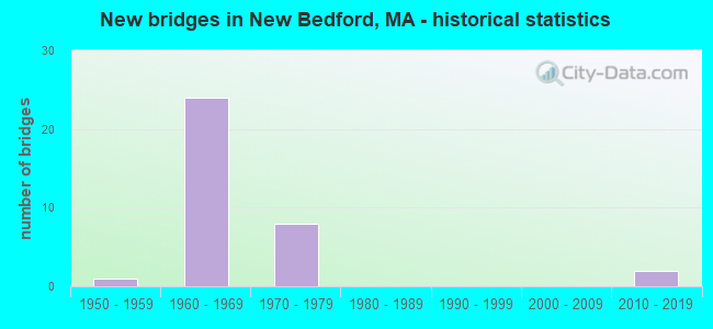
- New bridges - historical statistics
- 11950-1959
- 241960-1969
- 81970-1979
- 22010-2019
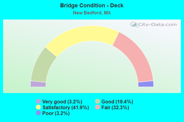
- Bridge Condition - Deck
- 3.2%Very good
- 19.4%Good
- 41.9%Satisfactory
- 32.3%Fair
- 3.2%Poor
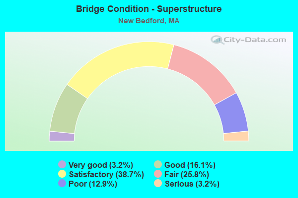
- Bridge Condition - Superstructure
- 3.2%Very good
- 16.1%Good
- 38.7%Satisfactory
- 25.8%Fair
- 12.9%Poor
- 3.2%Serious
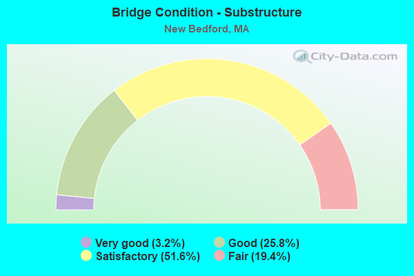
- Bridge Condition - Substructure
- 3.2%Very good
- 25.8%Good
- 51.6%Satisfactory
- 19.4%Fair
Find on map >> Show street view
Structure Number: N060133NHDOTNBI, Location: .9 MI SE OF FREETOWN T.L. (Lat: 41.726758, Lng: -70.948711), Route carried "on" structure: State highway 140, Year Built: 1955, Status: Open, Structure Length: 4.24m (13.91ft), Average Daily Traffic: 23,309 (year 2019), Truck Traffic: 4%, Average Future Daily Traffic: 34,745 (year 2032), Design Load: H 20, Features Intersected: HWY BRALEY RD
Minimum Vertical Clearance: 30+ m (98+ ft), Kilometerpoint: 10.831, Lanes on structure: 2, Lanes under structure: 2, Base Highway Network: Yes, Owner: State Highway Agency, Approaching Roadway Width: 13.4m (44.0ft), Skew: 2 degrees, Material/Design: Steel, Design/Construction: Stringer/Multi-beam, Number Of Spans In Main Unit: 3, Length of Maximum Span: 18.1m (59.4ft), Curb-To-Curb Width: 14.2m (46.6ft), Out-to-Out Width: 14.9m (48.9ft)
Condition: Deck: Fair, Superstructure: Satisfactory, Substructure: Good, Operating Rating: 34.0 metric tons, Method Used To Determine Operating Rating: Allowable Stress (AS), Inventory Rating: 17.5 metric tons, Method Used To Determine Inventory Rating: Allowable Stress (AS), Structural Evaluation: Meets minimum limits, Deck Geometry: Superior to present desirable criteria, Underclear: Meets minimum limits, Approach Roadway Alignment: Equal to present desirable criteria, Length Of Structure Improvement: 4.30m (14.11ft), Designated Inspection Frequency: Every 24 months, Inspection Date: August 2021, Bridge Improvement Cost: $2,517,000, Roadway Improvement Cost: $252,000, Total Project Cost: $3,776,000 ( Estimate for 2022), Deck Structure Type: Concrete Cast-file-Place, Wearing Surface/Protective System: Wearing Surface: Latex Concrete
Find on map >> Show street view
Structure Number: N060133NJDOTNBI, Location: .9 MI SE OF FREETOWN T.L. (Lat: 41.726731, Lng: -70.948989), Route carried "on" structure: State highway 140, Year Built: 1964, Status: Open, Structure Length: 4.21m (13.81ft), Average Daily Traffic: 25,000 (year 2019), Truck Traffic: 5%, Average Future Daily Traffic: 34,745 (year 2032), Design Load: H 20, Features Intersected: HWY BRALEY RD
Minimum Vertical Clearance: 30+ m (98+ ft), Kilometerpoint: 10.831, Lanes on structure: 2, Lanes under structure: 2, Base Highway Network: Yes, Owner: State Highway Agency, Approaching Roadway Width: 11.8m (38.7ft), Skew: 2 degrees, Material/Design: Steel, Design/Construction: Stringer/Multi-beam, Number Of Spans In Main Unit: 3, Length of Maximum Span: 18.6m (61.0ft), Curb-To-Curb Width: 11.8m (38.7ft), Out-to-Out Width: 13.0m (42.7ft)
Condition: Deck: Fair, Superstructure: Satisfactory, Substructure: Good, Operating Rating: 56.1 metric tons, Method Used To Determine Operating Rating: Load Factor (LF), Inventory Rating: 33.7 metric tons, Method Used To Determine Inventory Rating: Load Factor (LF), Structural Evaluation: Equal to present minimum criteria, Deck Geometry: Equal to present minimum criteria, Underclear: Meets minimum limits, Approach Roadway Alignment: Equal to present desirable criteria, Length Of Structure Improvement: 4.30m (14.11ft), Designated Inspection Frequency: Every 24 months, Inspection Date: August 2021, Bridge Improvement Cost: $2,162,000, Roadway Improvement Cost: $217,000, Total Project Cost: $3,244,000 ( Estimate for 2022), Deck Structure Type: Concrete Cast-file-Place, Wearing Surface/Protective System: Wearing Surface: Bituminous, Membrane: Built-up
Find on map >> Show street view
Structure Number: N0601471FDOTNBI, Location: 1/2MI N OF BUTTONWOOD PK (Lat: 41.652331, Lng: -70.953481), Route carried "on" structure: Interstate 195, Year Built: 2011, Status: Open, Structure Length: 5.07m (16.63ft), Average Daily Traffic: 76,820 (year 2018), Truck Traffic: 6%, Average Future Daily Traffic: 116,079 (year 2032), Design Load: HS 25 or greater, Features Intersected: ST140
Minimum Vertical Clearance: 30+ m (98+ ft), Kilometerpoint: 38.300, Lanes on structure: 8, Lanes under structure: 6, Owner: State Highway Agency, Approaching Roadway Width: 36.8m (120.7ft), Skew: 30 degrees, Material/Design: Steel continuous, Design/Construction: Stringer/Multi-beam, Number Of Spans In Main Unit: 2, Length of Maximum Span: 24.3m (79.7ft), Curb-To-Curb Width: 36.8m (120.7ft), Out-to-Out Width: 37.9m (124.3ft)
Condition: Deck: Good, Superstructure: Good, Substructure: Good, Operating Rating: 83.4 metric tons, Method Used To Determine Operating Rating: Load Factor (LF), Inventory Rating: 49.9 metric tons, Method Used To Determine Inventory Rating: Load Factor (LF), Structural Evaluation: Better than present minimum criteria, Deck Geometry: Better than present minimum criteria, Underclear: Equal to present minimum criteria, Approach Roadway Alignment: Equal to present desirable criteria, Length Of Structure Improvement: 5.10m (16.73ft), Designated Inspection Frequency: Every 24 months, Inspection Date: September 2021, Bridge Improvement Cost: $34,000, Roadway Improvement Cost: $4,000, Total Project Cost: $52,000 ( Estimate for 2022), Deck Structure Type: Concrete Cast-file-Place, Wearing Surface/Protective System: Wearing Surface: Bituminous, Membrane: Built-up, Deck Protection: Epoxy Coated Reinforcing
Find on map >> Show street view
Structure Number: N060153WRDOTNBI, Location: .5 MI E OF ST 140 (Lat: 41.652431, Lng: -70.943433), Route carried "on" structure: City street , Year Built: 1963, Status: Open, Structure Length: 6.25m (20.51ft), Average Daily Traffic: 23,000 (year 2016), Truck Traffic: 6%, Average Future Daily Traffic: 36,324 (year 2031), Design Load: HS 20, Features Intersected: I 195, Facility Carried by Structure: HWY SHAWMUT AVE
Minimum Vertical Clearance: 30+ m (98+ ft), Kilometerpoint: 1.609, Lanes on structure: 2, Lanes under structure: 4, Owner: State Highway Agency, Approaching Roadway Width: 12.2m (40.0ft), Skew: 1 degrees, Material/Design: Steel, Design/Construction: Stringer/Multi-beam, Number Of Spans In Main Unit: 4, Length of Maximum Span: 20.1m (65.9ft), Curb or Sidewalk Widths: Left: 1.8m (5.9ft), Right: 1.8m (5.9ft), Curb-To-Curb Width: 12.2m (40.0ft), Out-to-Out Width: 15.9m (52.2ft)
Condition: Deck: Good, Superstructure: Fair, Substructure: Fair, Operating Rating: 57.3 metric tons, Method Used To Determine Operating Rating: Load Factor (LF), Inventory Rating: 27.4 metric tons, Method Used To Determine Inventory Rating: Load Factor (LF), Structural Evaluation: Somewhat better than minimum adequacy, Deck Geometry: Somewhat better than minimum adequacy, Underclear: High priority of corrective action, Approach Roadway Alignment: Equal to present desirable criteria, Length Of Structure Improvement: 6.30m (20.67ft), Designated Inspection Frequency: Every 24 months, Inspection Date: May 2020, Bridge Improvement Cost: $3,935,000, Roadway Improvement Cost: $394,000, Total Project Cost: $5,903,000 ( Estimate for 2022), Deck Structure Type: Concrete Cast-file-Place, Wearing Surface/Protective System: Wearing Surface: Bituminous, Membrane: Built-up
Find on map >> Show street view
Structure Number: N060163XWDOTNBI, Location: .7 MI E OF ST 140 (Lat: 41.652864, Lng: -70.939486), Route carried "on" structure: City street , Year Built: 1963, Status: Open, Structure Length: 7.01m (23.00ft), Average Daily Traffic: 550 (year 2021), Truck Traffic: 6%, Average Future Daily Traffic: 2,527 (year 2032), Design Load: HS 20, Features Intersected: I 195, Facility Carried by Structure: HWY HIGHLAND ST
Minimum Vertical Clearance: 30+ m (98+ ft), Kilometerpoint: 0.000, Lanes on structure: 2, Lanes under structure: 4, Owner: State Highway Agency, Approaching Roadway Width: 9.8m (32.2ft), Skew: 1 degrees, Material/Design: Steel, Design/Construction: Stringer/Multi-beam, Number Of Spans In Main Unit: 4, Length of Maximum Span: 20.4m (66.9ft), Curb or Sidewalk Widths: Left: 1.5m (4.9ft), Right: 1.5m (4.9ft), Curb-To-Curb Width: 9.8m (32.2ft), Out-to-Out Width: 13.5m (44.3ft)
Condition: Deck: Good, Superstructure: Good, Substructure: Satisfactory, Operating Rating: 52.9 metric tons, Method Used To Determine Operating Rating: Load Factor (LF), Inventory Rating: 31.7 metric tons, Method Used To Determine Inventory Rating: Load Factor (LF), Structural Evaluation: Equal to present minimum criteria, Deck Geometry: Equal to present minimum criteria, Underclear: Meets minimum limits, Approach Roadway Alignment: Equal to present desirable criteria, Length Of Structure Improvement: 7.10m (23.29ft), Designated Inspection Frequency: Every 24 months, Inspection Date: August 2021, Bridge Improvement Cost: $3,765,000, Roadway Improvement Cost: $377,000, Total Project Cost: $5,648,000 ( Estimate for 2022), Deck Structure Type: Concrete Cast-file-Place, Wearing Surface/Protective System: Wearing Surface: Bituminous, Membrane: Built-up
Find on map >> Show street view
Structure Number: N060173XYDOTNBI, Location: .3 MI SW OF I 195 (Lat: 41.648222, Lng: -70.955422), Route carried "on" structure: Other road , Year Built: 1963, Status: Open, Structure Length: 5.85m (19.19ft), Average Daily Traffic: 11,100 (year 2021), Truck Traffic: 5%, Average Future Daily Traffic: 20,057 (year 2032), Design Load: H 20, Features Intersected: ST140, Facility Carried by Structure: HWY ROCKDALE AVE
Minimum Vertical Clearance: 30+ m (98+ ft), Kilometerpoint: 0.000, Lanes on structure: 2, Lanes under structure: 6, Owner: State Highway Agency, Approaching Roadway Width: 9.8m (32.2ft), Skew: 2 degrees, Material/Design: Steel, Design/Construction: Stringer/Multi-beam, Number Of Spans In Main Unit: 4, Length of Maximum Span: 18.3m (60.0ft), Curb or Sidewalk Widths: Left: 1.9m (6.2ft), Right: 1.9m (6.2ft), Curb-To-Curb Width: 9.8m (32.2ft), Out-to-Out Width: 13.5m (44.3ft)
Condition: Deck: Good, Superstructure: Fair, Substructure: Satisfactory, Operating Rating: 52.9 metric tons, Method Used To Determine Operating Rating: Load Factor (LF), Inventory Rating: 31.7 metric tons, Method Used To Determine Inventory Rating: Load Factor (LF), Structural Evaluation: Somewhat better than minimum adequacy, Deck Geometry: Meets minimum limits, Underclear: Meets minimum limits, Approach Roadway Alignment: Equal to present desirable criteria, Length Of Structure Improvement: 5.90m (19.36ft), Designated Inspection Frequency: Every 24 months, Inspection Date: December 2021, Bridge Improvement Cost: $3,129,000, Roadway Improvement Cost: $313,000, Total Project Cost: $4,694,000 ( Estimate for 2022), Deck Structure Type: Concrete Cast-file-Place, Wearing Surface/Protective System: Wearing Surface: Bituminous, Membrane: Built-up
Find on map >> Show street view
Structure Number: N060183NADOTNBI, Location: .4 MI N OF I 195 (Lat: 41.657242, Lng: -70.953094), Route carried "on" structure: State highway 140, Year Built: 1963, Year Reconstructed: 2004, Status: Open, Structure Length: 4.57m (14.99ft), Average Daily Traffic: 55,611 (year 2019), Truck Traffic: 4%, Average Future Daily Traffic: 76,752 (year 2032), Design Load: H 20, Features Intersected: HWY HATHAWAY RD
Minimum Vertical Clearance: 30+ m (98+ ft), Kilometerpoint: 2.253, Lanes on structure: 6, Lanes under structure: 2, Base Highway Network: Yes, Owner: State Highway Agency, Approaching Roadway Width: 24.4m (80.1ft), Skew: 33 degrees, Material/Design: Steel, Design/Construction: Stringer/Multi-beam, Number Of Spans In Main Unit: 3, Length of Maximum Span: 21.6m (70.9ft), Curb-To-Curb Width: 24.4m (80.1ft), Out-to-Out Width: 30.8m (101.0ft)
Condition: Deck: Good, Superstructure: Satisfactory, Substructure: Satisfactory, Operating Rating: 41.0 metric tons, Method Used To Determine Operating Rating: Allowable Stress (AS), Inventory Rating: 21.2 metric tons, Method Used To Determine Inventory Rating: Allowable Stress (AS), Structural Evaluation: Somewhat better than minimum adequacy, Deck Geometry: Meets minimum limits, Underclear: High priority of corrective action, Approach Roadway Alignment: Equal to present desirable criteria, Length Of Structure Improvement: 4.60m (15.09ft), Designated Inspection Frequency: Every 24 months, Inspection Date: November 2021, Bridge Improvement Cost: $5,566,000, Roadway Improvement Cost: $557,000, Total Project Cost: $8,350,000 ( Estimate for 2022), Deck Structure Type: Concrete Cast-file-Place, Wearing Surface/Protective System: Wearing Surface: Monolithic Concrete, Deck Protection: Epoxy Coated Reinforcing
Find on map >> Show street view
Structure Number: N060193XXDOTNBI, Location: .2 MI WEST OF ST 18 (Lat: 41.653114, Lng: -70.937272), Route carried "on" structure: City street , Year Built: 1963, Status: Open, Structure Length: 6.46m (21.19ft), Average Daily Traffic: 7,421 (year 2019), Truck Traffic: 5%, Average Future Daily Traffic: 17,696 (year 2031), Design Load: HS 20, Features Intersected: I 195, Facility Carried by Structure: HWY MNT PLSNT ST
Minimum Vertical Clearance: 30+ m (98+ ft), Kilometerpoint: 40.072, Lanes on structure: 2, Lanes under structure: 6, Owner: State Highway Agency, Approaching Roadway Width: 9.8m (32.2ft), Skew: 1 degrees, Material/Design: Steel, Design/Construction: Stringer/Multi-beam, Number Of Spans In Main Unit: 4, Length of Maximum Span: 21.3m (69.9ft), Curb or Sidewalk Widths: Left: 1.8m (5.9ft), Right: 1.8m (5.9ft), Curb-To-Curb Width: 9.8m (32.2ft), Out-to-Out Width: 13.4m (44.0ft)
Condition: Deck: Satisfactory, Superstructure: Satisfactory, Substructure: Satisfactory, Operating Rating: 52.1 metric tons, Method Used To Determine Operating Rating: Load Factor (LF), Inventory Rating: 31.2 metric tons, Method Used To Determine Inventory Rating: Load Factor (LF), Structural Evaluation: Equal to present minimum criteria, Deck Geometry: Meets minimum limits, Underclear: Meets minimum limits, Approach Roadway Alignment: Equal to present desirable criteria, Length Of Structure Improvement: 6.50m (21.33ft), Designated Inspection Frequency: Every 24 months, Inspection Date: September 2020, Bridge Improvement Cost: $3,422,000, Roadway Improvement Cost: $343,000, Total Project Cost: $5,134,000 ( Estimate for 2022), Deck Structure Type: Concrete Cast-file-Place, Wearing Surface/Protective System: Wearing Surface: Bituminous, Membrane: Built-up
Find on map >> Show street view
Structure Number: N060203TUDOTNBI, Location: I 195 AT ST 18 (Lat: 41.654383, Lng: -70.930019), Route carried "on" structure: Ramp Interstate 195, Year Built: 1965, Status: Temporarily open, Structure Length: 12.50m (41.01ft), Average Daily Traffic: 7,379 (year 2019), Truck Traffic: 7%, Average Future Daily Traffic: 31,586 (year 2032), Design Load: HS 20, Features Intersected: OTHER RELIEF
Minimum Vertical Clearance: 5.51m (18.08ft), Kilometerpoint: 40.554, Lanes on structure: 1, Base Highway Network: Yes, Owner: State Highway Agency, Approaching Roadway Width: 6.7m (22.0ft), Skew: 9 degrees, Material/Design: Steel, Design/Construction: Stringer/Multi-beam, Number Of Spans In Main Unit: 7, Length of Maximum Span: 18.3m (60.0ft), Curb or Sidewalk Widths: Left: 0.5m (1.6ft), Right: 0.5m (1.6ft), Curb-To-Curb Width: 6.7m (22.0ft), Out-to-Out Width: 8.6m (28.2ft)
Condition: Deck: Fair, Superstructure: Poor, Substructure: Satisfactory, Operating Rating: 57.6 metric tons, Method Used To Determine Operating Rating: Load Factor (LF), Inventory Rating: 34.5 metric tons, Method Used To Determine Inventory Rating: Load Factor (LF), Structural Evaluation: Meets minimum limits, Deck Geometry: Equal to present minimum criteria, Approach Roadway Alignment: Better than present minimum criteria, Length Of Structure Improvement: 12.60m (41.34ft), Designated Inspection Frequency: Every 12 months, Other Special Inspection Frequency: Every 12 months, Inspection Date: October 2021, Other Special Inspection Date: October 2021, Bridge Improvement Cost: $4,257,000, Roadway Improvement Cost: $426,000, Total Project Cost: $6,386,000 ( Estimate for 2022), Deck Structure Type: Concrete Cast-file-Place, Wearing Surface/Protective System: Wearing Surface: Monolithic Concrete
Find on map >> Show street view
Structure Number: N060203TVDOTNBI, Location: I 195 AT ST 18 (Lat: 41.653453, Lng: -70.929128), Route carried "on" structure: Ramp Interstate 195, Year Built: 1965, Status: Temporarily open, Structure Length: 20.92m (68.64ft), Average Daily Traffic: 9,695 (year 2019), Truck Traffic: 6%, Average Future Daily Traffic: 22,110 (year 2032), Design Load: HS 20, Features Intersected: COMB WELD ST & RELIEF
Minimum Vertical Clearance: 5.18m (16.99ft), Kilometerpoint: 40.587, Lanes on structure: 1, Lanes under structure: 1, Owner: State Highway Agency, Approaching Roadway Width: 6.7m (22.0ft), Skew: 4 degrees, Material/Design: Steel, Design/Construction: Stringer/Multi-beam, Number Of Spans In Main Unit: 11, Length of Maximum Span: 18.3m (60.0ft), Curb or Sidewalk Widths: Left: 0.5m (1.6ft), Right: 0.5m (1.6ft), Curb-To-Curb Width: 6.7m (22.0ft), Out-to-Out Width: 8.6m (28.2ft)
Condition: Deck: Poor, Superstructure: Poor, Substructure: Satisfactory, Operating Rating: 57.6 metric tons, Method Used To Determine Operating Rating: Load Factor (LF), Inventory Rating: 34.5 metric tons, Method Used To Determine Inventory Rating: Load Factor (LF), Structural Evaluation: Meets minimum limits, Deck Geometry: Equal to present minimum criteria, Underclear: High priority of corrective action, Approach Roadway Alignment: Better than present minimum criteria, Length Of Structure Improvement: 21.00m (68.90ft), Designated Inspection Frequency: Every 12 months, Other Special Inspection Frequency: Every 12 months, Inspection Date: October 2021, Other Special Inspection Date: October 2021, Bridge Improvement Cost: $7,094,000, Roadway Improvement Cost: $710,000, Total Project Cost: $10,642,000 ( Estimate for 2022), Deck Structure Type: Concrete Cast-file-Place, Wearing Surface/Protective System: Wearing Surface: Monolithic Concrete
Find on map >> Show street view
Structure Number: N060203TYDOTNBI, Location: .1 MI W OF ST 18 (Lat: 41.653903, Lng: -70.930394), Route carried "on" structure: Interstate 195, Year Built: 1965, Status: Temporarily open, Structure Length: 10.35m (33.96ft), Average Daily Traffic: 63,995 (year 2016), Truck Traffic: 9%, Average Future Daily Traffic: 89,230 (year 2032), Design Load: HS 20, Features Intersected: COMB MACRR/PURCHASE ST
Minimum Vertical Clearance: 4.88m (16.01ft), Kilometerpoint: 40.715, Lanes on structure: 6, Lanes under structure: 2, Base Highway Network: Yes, Owner: State Highway Agency, Approaching Roadway Width: 22.6m (74.1ft), Skew: 20 degrees, Material/Design: Steel, Design/Construction: Stringer/Multi-beam, Number Of Spans In Main Unit: 4, Length of Maximum Span: 31.7m (104.0ft), Curb or Sidewalk Widths: Left: 0.5m (1.6ft), Right: 0.5m (1.6ft), Curb-To-Curb Width: 22.6m (74.1ft), Out-to-Out Width: 26.9m (88.3ft)
Condition: Deck: Fair, Superstructure: Poor, Substructure: Fair, Operating Rating: 24.3 metric tons, Method Used To Determine Operating Rating: Load Factor (LF), Inventory Rating: 20.4 metric tons, Method Used To Determine Inventory Rating: Load Factor (LF), Structural Evaluation: Meets minimum limits, Deck Geometry: Meets minimum limits, Underclear: Superior to present desirable criteria, Approach Roadway Alignment: Equal to present desirable criteria, Bridge Posting: Required (Relationship of Operating Rating to Maximum Legal Load: 20.0 - 29.9% below), Length Of Structure Improvement: 11.30m (37.07ft), Designated Inspection Frequency: Every 12 months, Other Special Inspection Frequency: Every 12 months, Inspection Date: October 2021, Other Special Inspection Date: October 2021, Bridge Improvement Cost: $20,007,000, Roadway Improvement Cost: $2,001,000, Total Project Cost: $30,011,000 ( Estimate for 2022), Deck Structure Type: Concrete Cast-file-Place, Wearing Surface/Protective System: Wearing Surface: Bituminous, Membrane: Built-up
Find on map >> Show street view
Structure Number: N060203U0DOTNBI, Location: .1 MI W OF ST 18 (Lat: 41.653750, Lng: -70.931761), Route carried "on" structure: Interstate 195, Year Built: 1965, Status: Open, Structure Length: 14.02m (46.00ft), Average Daily Traffic: 63,995 (year 2016), Truck Traffic: 9%, Average Future Daily Traffic: 89,230 (year 2032), Design Load: HS 20, Features Intersected: HWY COUNTY&STATE STS
Minimum Vertical Clearance: 4.93m (16.17ft), Kilometerpoint: 40.715, Lanes on structure: 5, Lanes under structure: 4, Base Highway Network: Yes, Owner: State Highway Agency, Approaching Roadway Width: 22.6m (74.1ft), Skew: 20 degrees, Material/Design: Steel, Design/Construction: Stringer/Multi-beam, Number Of Spans In Main Unit: 5, Length of Maximum Span: 28.3m (92.8ft), Curb or Sidewalk Widths: Left: 0.5m (1.6ft), Right: 0.5m (1.6ft), Curb-To-Curb Width: 22.6m (74.1ft), Out-to-Out Width: 26.9m (88.3ft)
Condition: Deck: Satisfactory, Superstructure: Poor, Substructure: Fair, Operating Rating: 56.9 metric tons, Method Used To Determine Operating Rating: Load Factor (LF), Inventory Rating: 34.1 metric tons, Method Used To Determine Inventory Rating: Load Factor (LF), Structural Evaluation: Meets minimum limits, Deck Geometry: Meets minimum limits, Underclear: High priority of corrective action, Approach Roadway Alignment: Equal to present desirable criteria, Length Of Structure Improvement: 14.10m (46.26ft), Designated Inspection Frequency: Every 12 months, Other Special Inspection Frequency: Every 12 months, Inspection Date: October 2021, Other Special Inspection Date: October 2021, Bridge Improvement Cost: $14,899,000, Roadway Improvement Cost: $1,490,000, Total Project Cost: $22,349,000 ( Estimate for 2022), Deck Structure Type: Concrete Cast-file-Place, Wearing Surface/Protective System: Wearing Surface: Bituminous, Membrane: Built-up
Find on map >> Show street view
Structure Number: N060203U1DOTNBI, Location: .25 MI E OF PENNIMAN ST (Lat: 41.654094, Lng: -70.928639), Route carried "on" structure: Interstate 195, Year Built: 1965, Status: Temporarily open, Structure Length: 15.26m (50.07ft), Average Daily Traffic: 66,254 (year 2019), Truck Traffic: 2%, Average Future Daily Traffic: 73,122 (year 2032), Design Load: HS 20, Features Intersected: ST 18 ASHLEY BLVD
Minimum Vertical Clearance: 30+ m (98+ ft), Kilometerpoint: 40.393, Lanes on structure: 5, Lanes under structure: 7, Base Highway Network: Yes, Owner: State Highway Agency, Approaching Roadway Width: 22.6m (74.1ft), Skew: 30 degrees, Material/Design: Steel, Design/Construction: Stringer/Multi-beam, Number Of Spans In Main Unit: 6, Length of Maximum Span: 28.3m (92.8ft), Curb or Sidewalk Widths: Left: 0.5m (1.6ft), Right: 0.5m (1.6ft), Curb-To-Curb Width: 22.6m (74.1ft), Out-to-Out Width: 26.9m (88.3ft)
Condition: Deck: Satisfactory, Superstructure: Serious, Substructure: Fair, Operating Rating: 56.4 metric tons, Method Used To Determine Operating Rating: Load Factor (LF), Inventory Rating: 33.7 metric tons, Method Used To Determine Inventory Rating: Load Factor (LF), Structural Evaluation: High priority of corrective action, Deck Geometry: Meets minimum limits, Underclear: High priority of corrective action, Approach Roadway Alignment: Equal to present desirable criteria, Bridge Posting: Required (Relationship of Operating Rating to Maximum Legal Load: > 39.9% below), Length Of Structure Improvement: 15.30m (50.20ft), Designated Inspection Frequency: Every 6 months, Other Special Inspection Frequency: Every 6 months, Inspection Date: October 2021, Other Special Inspection Date: October 2021, Bridge Improvement Cost: $16,167,000, Roadway Improvement Cost: $1,617,000, Total Project Cost: $24,251,000 ( Estimate for 2022), Deck Structure Type: Concrete Cast-file-Place, Wearing Surface/Protective System: Wearing Surface: Bituminous, Membrane: Built-up
Find on map >> Show street view
Structure Number: N060213TXDOTNBI, Location: .4 MI W OF FAIRHVN T.L. (Lat: 41.654508, Lng: -70.925008), Route carried "on" structure: Interstate 195, Year Built: 1965, Status: Open, Structure Length: 1.52m (4.99ft), Average Daily Traffic: 59,700 (year 2019), Truck Traffic: 3%, Average Future Daily Traffic: 89,230 (year 2032), Design Load: H 20, Features Intersected: HWY N FRONT ST
Minimum Vertical Clearance: 30+ m (98+ ft), Kilometerpoint: 40.554, Lanes on structure: 5, Lanes under structure: 2, Base Highway Network: Yes, Owner: State Highway Agency, Approaching Roadway Width: 28.3m (92.8ft), Skew: 30 degrees, Material/Design: Steel, Design/Construction: Stringer/Multi-beam, Number Of Spans In Main Unit: 1, Length of Maximum Span: 14.6m (47.9ft), Curb or Sidewalk Widths: Left: 0.5m (1.6ft), Right: 0.5m (1.6ft), Curb-To-Curb Width: 28.3m (92.8ft), Out-to-Out Width: 32.6m (107.0ft)
Condition: Deck: Satisfactory, Superstructure: Satisfactory, Substructure: Good, Operating Rating: 53.5 metric tons, Method Used To Determine Operating Rating: Load Factor (LF), Inventory Rating: 32.1 metric tons, Method Used To Determine Inventory Rating: Load Factor (LF), Structural Evaluation: Equal to present minimum criteria, Deck Geometry: Superior to present desirable criteria, Underclear: Meets minimum limits, Approach Roadway Alignment: Equal to present desirable criteria, Length Of Structure Improvement: 1.60m (5.25ft), Designated Inspection Frequency: Every 24 months, Inspection Date: June 2021, Bridge Improvement Cost: $2,049,000, Roadway Improvement Cost: $205,000, Total Project Cost: $3,074,000 ( Estimate for 2022), Deck Structure Type: Concrete Cast-file-Place, Wearing Surface/Protective System: Wearing Surface: Bituminous, Membrane: Built-up
Find on map >> Show street view
Structure Number: N060223TWDOTNBI, Location: .4 MI W OF FAIHVN T L (Lat: 41.654692, Lng: -70.923458), Route carried "on" structure: Interstate 195, Year Built: 1965, Status: Open, Structure Length: 1.76m (5.77ft), Average Daily Traffic: 52,820 (year 2019), Truck Traffic: 6%, Average Future Daily Traffic: 131,556 (year 2031), Design Load: HS 20, Features Intersected: HWY BELLEVILLE AVE
Minimum Vertical Clearance: 30+ m (98+ ft), Kilometerpoint: 40.876, Lanes on structure: 5, Lanes under structure: 2, Base Highway Network: Yes, Owner: State Highway Agency, Approaching Roadway Width: 24.4m (80.1ft), Skew: 30 degrees, Material/Design: Steel, Design/Construction: Stringer/Multi-beam, Number Of Spans In Main Unit: 1, Length of Maximum Span: 16.0m (52.5ft), Curb or Sidewalk Widths: Left: 1.2m (3.9ft), Right: 0.5m (1.6ft), Curb-To-Curb Width: 24.4m (80.1ft), Out-to-Out Width: 29.9m (98.1ft)
Condition: Deck: Fair, Superstructure: Satisfactory, Substructure: Good, Operating Rating: 56.3 metric tons, Method Used To Determine Operating Rating: Load Factor (LF), Inventory Rating: 33.7 metric tons, Method Used To Determine Inventory Rating: Load Factor (LF), Structural Evaluation: Equal to present minimum criteria, Deck Geometry: Equal to present minimum criteria, Underclear: Meets minimum limits, Approach Roadway Alignment: Equal to present desirable criteria, Length Of Structure Improvement: 1.80m (5.91ft), Designated Inspection Frequency: Every 24 months, Inspection Date: July 2020, Bridge Improvement Cost: $1,929,000, Roadway Improvement Cost: $193,000, Total Project Cost: $2,894,000 ( Estimate for 2022), Deck Structure Type: Concrete Cast-file-Place, Wearing Surface/Protective System: Wearing Surface: Monolithic Concrete, Membrane: Built-up
Find on map >> Show street view
Structure Number: N060233PKDOTNBI, Location: .1 MI S OF I 195 (Lat: 41.651406, Lng: -70.927981), Route carried "on" structure: State highway 18, Year Built: 1965, Status: Open, Structure Length: 1.46m (4.79ft), Average Daily Traffic: 55,700 (year 2019), Truck Traffic: 4%, Average Future Daily Traffic: 112,288 (year 2031), Design Load: H 20, Features Intersected: HWY LOGAN ST
Minimum Vertical Clearance: 30+ m (98+ ft), Kilometerpoint: 3.219, Lanes on structure: 7, Lanes under structure: 2, Base Highway Network: Yes, Owner: State Highway Agency, Approaching Roadway Width: 28.7m (94.2ft), Skew: 10 degrees, Material/Design: Steel, Design/Construction: Stringer/Multi-beam, Number Of Spans In Main Unit: 1, Length of Maximum Span: 13.0m (42.7ft), Curb or Sidewalk Widths: Left: 0.5m (1.6ft), Right: 0.2m (0.7ft), Curb-To-Curb Width: 29.4m (96.5ft), Out-to-Out Width: 33.2m (108.9ft)
Condition: Deck: Fair, Superstructure: Good, Substructure: Good, Operating Rating: 40.5 metric tons, Method Used To Determine Operating Rating: Load Factor (LF), Inventory Rating: 24.3 metric tons, Method Used To Determine Inventory Rating: Load Factor (LF), Structural Evaluation: Equal to present minimum criteria, Deck Geometry: Meets minimum limits, Underclear: Meets minimum limits, Approach Roadway Alignment: Equal to present desirable criteria, Length Of Structure Improvement: 1.50m (4.92ft), Designated Inspection Frequency: Every 24 months, Inspection Date: June 2020, Bridge Improvement Cost: $1,957,000, Roadway Improvement Cost: $196,000, Total Project Cost: $2,936,000 ( Estimate for 2022), Deck Structure Type: Concrete Cast-file-Place, Wearing Surface/Protective System: Wearing Surface: Bituminous, Membrane: Built-up
Find on map >> Show street view
Structure Number: N060253WCDOTNBI, Location: 0.1MI N OF ROCKDALE AVE (Lat: 41.653231, Lng: -70.961111), Route carried "on" structure: City street , Year Built: 1966, Status: Open, Structure Length: 7.01m (23.00ft), Average Daily Traffic: 15,567 (year 2019), Truck Traffic: 6%, Average Future Daily Traffic: 58,434 (year 2032), Design Load: H 20, Features Intersected: I 195, Facility Carried by Structure: HWY HATHAWAY RD
Minimum Vertical Clearance: 30+ m (98+ ft), Kilometerpoint: 0.000, Lanes on structure: 2, Lanes under structure: 6, Owner: State Highway Agency, Approaching Roadway Width: 13.4m (44.0ft), Skew: 3 degrees, Material/Design: Steel, Design/Construction: Stringer/Multi-beam, Number Of Spans In Main Unit: 4, Length of Maximum Span: 23.5m (77.1ft), Curb or Sidewalk Widths: Left: 1.5m (4.9ft), Right: 1.5m (4.9ft), Curb-To-Curb Width: 13.4m (44.0ft), Out-to-Out Width: 17.3m (56.8ft)
Condition: Deck: Satisfactory, Superstructure: Satisfactory, Substructure: Satisfactory, Operating Rating: 54.1 metric tons, Method Used To Determine Operating Rating: Load Factor (LF), Inventory Rating: 32.4 metric tons, Method Used To Determine Inventory Rating: Load Factor (LF), Structural Evaluation: Equal to present minimum criteria, Deck Geometry: Equal to present minimum criteria, Underclear: High priority of corrective action, Approach Roadway Alignment: Equal to present desirable criteria, Length Of Structure Improvement: 7.10m (23.29ft), Designated Inspection Frequency: Every 24 months, Inspection Date: August 2021, Bridge Improvement Cost: $965,000, Roadway Improvement Cost: $97,000, Total Project Cost: $1,448,000 ( Estimate for 2022), Deck Structure Type: Concrete Cast-file-Place, Wearing Surface/Protective System: Wearing Surface: Monolithic Concrete
Find on map >> Show street view
Structure Number: N060263Q2DOTNBI, Location: .9 MI N OF PHILLIPS RD (Lat: 41.711839, Lng: -70.939244), Route carried "on" structure: Ramp State highway 140, Year Built: 1964, Status: Open, Structure Length: 3.60m (11.81ft), Average Daily Traffic: 7,100 (year 2016), Truck Traffic: 14%, Average Future Daily Traffic: 10,265 (year 2031), Design Load: H 20, Features Intersected: ST140 NB
Minimum Vertical Clearance: 30+ m (98+ ft), Kilometerpoint: 9.012, Lanes on structure: 1, Lanes under structure: 2, Base Highway Network: Yes, Owner: State Highway Agency, Approaching Roadway Width: 9.1m (29.9ft), Skew: 4 degrees, Material/Design: Steel, Design/Construction: Stringer/Multi-beam, Number Of Spans In Main Unit: 1, Length of Maximum Span: 35.1m (115.2ft), Curb or Sidewalk Widths: Left: 0.5m (1.6ft), Right: 0.5m (1.6ft), Curb-To-Curb Width: 9.1m (29.9ft), Out-to-Out Width: 11.0m (36.1ft)
Condition: Deck: Satisfactory, Superstructure: Satisfactory, Substructure: Satisfactory, Operating Rating: 61.1 metric tons, Method Used To Determine Operating Rating: Load Factor (LF), Inventory Rating: 36.6 metric tons, Method Used To Determine Inventory Rating: Load Factor (LF), Structural Evaluation: Equal to present minimum criteria, Deck Geometry: Superior to present desirable criteria, Underclear: High priority of corrective action, Approach Roadway Alignment: Equal to present desirable criteria, Length Of Structure Improvement: 3.70m (12.14ft), Designated Inspection Frequency: Every 24 months, Inspection Date: July 2020, Bridge Improvement Cost: $320,000, Roadway Improvement Cost: $33,000, Total Project Cost: $481,000 ( Estimate for 2022), Deck Structure Type: Concrete Cast-file-Place, Wearing Surface/Protective System: Wearing Surface: Bituminous, Membrane: Built-up
Find on map >> Show street view
Structure Number: N060273Y0DOTNBI, Location: 1.5 MI S OF BRALEY RD (Lat: 41.703369, Lng: -70.943806), Route carried "on" structure: City street , Year Built: 1964, Status: Open, Structure Length: 6.52m (21.39ft), Average Daily Traffic: 18,103 (year 2020), Truck Traffic: 5%, Average Future Daily Traffic: 39,482 (year 2033), Design Load: H 20, Features Intersected: ST140, Facility Carried by Structure: HWY PHILLIPS RD
Minimum Vertical Clearance: 30+ m (98+ ft), Kilometerpoint: 0.000, Lanes on structure: 2, Lanes under structure: 4, Owner: State Highway Agency, Approaching Roadway Width: 13.4m (44.0ft), Skew: 3 degrees, Material/Design: Steel, Design/Construction: Stringer/Multi-beam, Number Of Spans In Main Unit: 2, Length of Maximum Span: 32.6m (107.0ft), Curb or Sidewalk Widths: Left: 1.5m (4.9ft), Right: 1.5m (4.9ft), Curb-To-Curb Width: 13.5m (44.3ft), Out-to-Out Width: 17.3m (56.8ft)
Condition: Deck: Satisfactory, Superstructure: Fair, Substructure: Good, Operating Rating: 51.4 metric tons, Method Used To Determine Operating Rating: Load Factor (LF), Inventory Rating: 30.8 metric tons, Method Used To Determine Inventory Rating: Load Factor (LF), Structural Evaluation: Somewhat better than minimum adequacy, Deck Geometry: Superior to present desirable criteria, Underclear: High priority of corrective action, Approach Roadway Alignment: Equal to present desirable criteria, Length Of Structure Improvement: 6.60m (21.65ft), Designated Inspection Frequency: Every 24 months, Inspection Date: January 2022, Bridge Improvement Cost: $4,485,000, Roadway Improvement Cost: $449,000, Total Project Cost: $6,728,000 ( Estimate for 2022), Deck Structure Type: Concrete Cast-file-Place, Wearing Surface/Protective System: Wearing Surface: Bituminous, Membrane: Built-up
Find on map >> Show street view
Structure Number: N060293NYDOTNBI, Location: .75 MI W OF FAIRHAVEN TL (Lat: 41.637322, Lng: -70.923097), Route carried "on" structure: US 6, Year Built: 1973, Status: Open, Structure Length: 6.13m (20.11ft), Average Daily Traffic: 14,000 (year 2017), Truck Traffic: 10%, Average Future Daily Traffic: 22,110 (year 2032), Design Load: HS 20, Features Intersected: COMB ST18 & RELIEF
Minimum Vertical Clearance: 30+ m (98+ ft), Kilometerpoint: 0.016, Lanes on structure: 1, Lanes under structure: 4, Base Highway Network: Yes, Owner: State Highway Agency, Approaching Roadway Width: 8.5m (27.9ft), Skew: 3 degrees, Material/Design: Steel, Design/Construction: Stringer/Multi-beam, Number Of Spans In Main Unit: 3, Length of Maximum Span: 20.4m (66.9ft), Curb or Sidewalk Widths: Left: 0.3m (1.0ft), Right: 0.3m (1.0ft), Curb-To-Curb Width: 8.5m (27.9ft), Out-to-Out Width: 10.1m (33.1ft)
Condition: Deck: Fair, Superstructure: Satisfactory, Substructure: Fair, Operating Rating: 59.5 metric tons, Method Used To Determine Operating Rating: Load Factor (LF), Inventory Rating: 35.7 metric tons, Method Used To Determine Inventory Rating: Load Factor (LF), Structural Evaluation: Somewhat better than minimum adequacy, Deck Geometry: Meets minimum limits, Underclear: Somewhat better than minimum adequacy, Approach Roadway Alignment: Equal to present minimum criteria, Length Of Structure Improvement: 6.20m (20.34ft), Designated Inspection Frequency: Every 24 months, Inspection Date: December 2021, Bridge Improvement Cost: $2,460,000, Roadway Improvement Cost: $247,000, Total Project Cost: $3,691,000 ( Estimate for 2022), Deck Structure Type: Concrete Cast-file-Place, Wearing Surface/Protective System: Wearing Surface: Bituminous, Membrane: Built-up
Find on map >> Show street view
Structure Number: N060293P0DOTNBI, Location: .75 M W OF FAIRHAVEN TL (Lat: 41.637431, Lng: -70.923356), Route carried "on" structure: US 6, Year Built: 1973, Status: Open, Structure Length: 7.68m (25.20ft), Average Daily Traffic: 21,952 (year 2019), Truck Traffic: 4%, Average Future Daily Traffic: 28,269 (year 2032), Design Load: HS 20, Features Intersected: COMB ST18 & RELIEF
Minimum Vertical Clearance: 30+ m (98+ ft), Kilometerpoint: 0.016, Lanes on structure: 2, Lanes under structure: 4, Base Highway Network: Yes, Owner: State Highway Agency, Approaching Roadway Width: 8.5m (27.9ft), Skew: 3 degrees, Material/Design: Steel, Design/Construction: Stringer/Multi-beam, Number Of Spans In Main Unit: 3, Length of Maximum Span: 27.1m (88.9ft), Curb or Sidewalk Widths: Left: 0.3m (1.0ft), Right: 0.3m (1.0ft), Curb-To-Curb Width: 8.5m (27.9ft), Out-to-Out Width: 10.1m (33.1ft)
Condition: Deck: Satisfactory, Superstructure: Good, Substructure: Fair, Operating Rating: 61.1 metric tons, Method Used To Determine Operating Rating: Load Factor (LF), Inventory Rating: 36.6 metric tons, Method Used To Determine Inventory Rating: Load Factor (LF), Structural Evaluation: Somewhat better than minimum adequacy, Deck Geometry: High priority of corrective action, Underclear: Somewhat better than minimum adequacy, Approach Roadway Alignment: Equal to present desirable criteria, Length Of Structure Improvement: 7.70m (25.26ft), Designated Inspection Frequency: Every 24 months, Inspection Date: December 2021, Bridge Improvement Cost: $3,055,000, Roadway Improvement Cost: $306,000, Total Project Cost: $4,583,000 ( Estimate for 2022), Deck Structure Type: Concrete Cast-file-Place, Wearing Surface/Protective System: Wearing Surface: Bituminous, Membrane: Built-up
Find on map >> Show street view
Structure Number: N060303P1DOTNBI, Location: .7 MI W OF FAIRHVN T.L. (Lat: 41.638189, Lng: -70.925092), Route carried "on" structure: US 6, Year Built: 1973, Status: Open, Structure Length: 2.56m (8.40ft), Average Daily Traffic: 62,000 (year 2018), Truck Traffic: 5%, Average Future Daily Traffic: 18,952 (year 2033), Design Load: H 20, Features Intersected: ST 18 RAMP B
Minimum Vertical Clearance: 30+ m (98+ ft), Kilometerpoint: 44.256, Lanes on structure: 2, Lanes under structure: 1, Base Highway Network: Yes, Owner: State Highway Agency, Approaching Roadway Width: 8.5m (27.9ft), Skew: 3 degrees, Material/Design: Steel, Design/Construction: Stringer/Multi-beam, Number Of Spans In Main Unit: 1, Length of Maximum Span: 24.7m (81.0ft), Curb-To-Curb Width: 8.5m (27.9ft), Out-to-Out Width: 10.1m (33.1ft)
Condition: Deck: Good, Superstructure: Good, Substructure: Good, Operating Rating: 59.9 metric tons, Method Used To Determine Operating Rating: Load Factor (LF), Inventory Rating: 35.9 metric tons, Method Used To Determine Inventory Rating: Load Factor (LF), Structural Evaluation: Better than present minimum criteria, Deck Geometry: High priority of corrective action, Underclear: High priority of corrective action, Approach Roadway Alignment: Equal to present desirable criteria, Length Of Structure Improvement: 2.60m (8.53ft), Designated Inspection Frequency: Every 24 months, Inspection Date: March 2020, Bridge Improvement Cost: $1,055,000, Roadway Improvement Cost: $106,000, Total Project Cost: $1,583,000 ( Estimate for 2022), Deck Structure Type: Concrete Cast-file-Place, Wearing Surface/Protective System: Wearing Surface: Bituminous, Membrane: Built-up
Find on map >> Show street view
Structure Number: N060313Y1DOTNBI, Location: .2 MI NW OF US 6 (Lat: 41.640044, Lng: -70.925431), Route carried "on" structure: City street , Year Built: 1973, Status: Open, Structure Length: 5.67m (18.60ft), Average Daily Traffic: 13,500 (year 2019), Truck Traffic: 6%, Average Future Daily Traffic: 25,743 (year 2032), Design Load: HS 20, Features Intersected: ST 18 & RAMP A, Facility Carried by Structure: HWY HILLMAN ST
Minimum Vertical Clearance: 30+ m (98+ ft), Kilometerpoint: 0.000, Lanes on structure: 2, Lanes under structure: 7, Owner: State Highway Agency, Approaching Roadway Width: 12.2m (40.0ft), Material/Design: Steel, Design/Construction: Stringer/Multi-beam, Number Of Spans In Main Unit: 3, Length of Maximum Span: 22.9m (75.1ft), Curb or Sidewalk Widths: Left: 0.5m (1.6ft), Right: 1.8m (5.9ft), Curb-To-Curb Width: 12.2m (40.0ft), Out-to-Out Width: 15.2m (49.9ft)
Condition: Deck: Fair, Superstructure: Fair, Substructure: Satisfactory, Operating Rating: 44.7 metric tons, Method Used To Determine Operating Rating: Load Factor (LF), Inventory Rating: 26.8 metric tons, Method Used To Determine Inventory Rating: Load Factor (LF), Structural Evaluation: Somewhat better than minimum adequacy, Deck Geometry: Somewhat better than minimum adequacy, Underclear: High priority of corrective action, Approach Roadway Alignment: Equal to present desirable criteria, Length Of Structure Improvement: 5.70m (18.70ft), Designated Inspection Frequency: Every 24 months, Inspection Date: March 2021, Bridge Improvement Cost: $3,404,000, Roadway Improvement Cost: $341,000, Total Project Cost: $5,107,000 ( Estimate for 2022), Deck Structure Type: Concrete Cast-file-Place, Wearing Surface/Protective System: Wearing Surface: Bituminous, Membrane: Preformed Fabric
Find on map >> Show street view
Structure Number: N060323NBDOTNBI, Location: .8 MI NE OF I 195 (Lat: 41.661733, Lng: -70.948583), Route carried "on" structure: State highway 140, Year Built: 1970, Status: Open, Structure Length: 3.12m (10.24ft), Average Daily Traffic: 55,611 (year 2019), Truck Traffic: 4%, Average Future Daily Traffic: 107,866 (year 2031), Design Load: H 20, Features Intersected: HWY SHAWMUT AVE
Minimum Vertical Clearance: 30+ m (98+ ft), Kilometerpoint: 3.058, Lanes on structure: 4, Lanes under structure: 2, Base Highway Network: Yes, Owner: State Highway Agency, Approaching Roadway Width: 25.0m (82.0ft), Skew: 21 degrees, Material/Design: Steel, Design/Construction: Stringer/Multi-beam, Number Of Spans In Main Unit: 1, Length of Maximum Span: 29.4m (96.5ft), Curb or Sidewalk Widths: Left: 0.2m (0.7ft), Right: 0.2m (0.7ft), Curb-To-Curb Width: 25.1m (82.3ft), Out-to-Out Width: 31.3m (102.7ft)
Condition: Deck: Fair, Superstructure: Satisfactory, Substructure: Satisfactory, Operating Rating: 56.1 metric tons, Method Used To Determine Operating Rating: Load Factor (LF), Inventory Rating: 33.6 metric tons, Method Used To Determine Inventory Rating: Load Factor (LF), Structural Evaluation: Equal to present minimum criteria, Deck Geometry: Superior to present desirable criteria, Underclear: Somewhat better than minimum adequacy, Approach Roadway Alignment: Equal to present desirable criteria, Length Of Structure Improvement: 3.20m (10.50ft), Designated Inspection Frequency: Every 24 months, Inspection Date: July 2020, Bridge Improvement Cost: $1,889,000, Roadway Improvement Cost: $189,000, Total Project Cost: $2,834,000 ( Estimate for 2022), Deck Structure Type: Concrete Cast-file-Place, Wearing Surface/Protective System: Wearing Surface: Bituminous, Membrane: Built-up
Find on map >> Show street view
Structure Number: N060333NCDOTNBI, Location: .9 MI NE OF I 195 (Lat: 41.662603, Lng: -70.947372), Route carried "on" structure: State highway 140, Year Built: 1970, Status: Open, Structure Length: 3.90m (12.80ft), Average Daily Traffic: 55,600 (year 2019), Truck Traffic: 4%, Average Future Daily Traffic: 84,966 (year 2031), Design Load: H 20, Features Intersected: RR BCRR
Minimum Vertical Clearance: 30+ m (98+ ft), Kilometerpoint: 0.000, Lanes on structure: 4, Base Highway Network: Yes, Owner: State Highway Agency, Approaching Roadway Width: 24.1m (79.1ft), Skew: 35 degrees, Material/Design: Steel, Design/Construction: Stringer/Multi-beam, Number Of Spans In Main Unit: 1, Length of Maximum Span: 37.5m (123.0ft), Curb or Sidewalk Widths: Left: 0.2m (0.7ft), Right: 0.2m (0.7ft), Curb-To-Curb Width: 23.8m (78.1ft), Out-to-Out Width: 29.9m (98.1ft)
Condition: Deck: Satisfactory, Superstructure: Fair, Substructure: Satisfactory, Operating Rating: 58.4 metric tons, Method Used To Determine Operating Rating: Load Factor (LF), Inventory Rating: 35.0 metric tons, Method Used To Determine Inventory Rating: Load Factor (LF), Structural Evaluation: Somewhat better than minimum adequacy, Deck Geometry: Superior to present desirable criteria, Underclear: High priority of corrective action, Approach Roadway Alignment: Equal to present desirable criteria, Length Of Structure Improvement: 4.00m (13.12ft), Designated Inspection Frequency: Every 24 months, Inspection Date: December 2020, Bridge Improvement Cost: $4,698,000, Roadway Improvement Cost: $470,000, Total Project Cost: $7,048,000 ( Estimate for 2022), Deck Structure Type: Concrete Cast-file-Place, Wearing Surface/Protective System: Wearing Surface: Bituminous, Membrane: Built-up
Find on map >> Show street view
Structure Number: N060343NEDOTNBI, Location: 1.3 MI NE OF I 195 (Lat: 41.665808, Lng: -70.943172), Route carried "on" structure: City street , Year Built: 1970, Status: Open, Structure Length: 7.07m (23.20ft), Average Daily Traffic: 11,285 (year 2022), Truck Traffic: 5%, Average Future Daily Traffic: 48,958 (year 2033), Design Load: H 20, Features Intersected: ST140, Facility Carried by Structure: HWY MT PLSNT ST
Minimum Vertical Clearance: 30+ m (98+ ft), Kilometerpoint: 0.000, Lanes on structure: 4, Lanes under structure: 4, Owner: State Highway Agency, Approaching Roadway Width: 15.8m (51.8ft), Skew: 4 degrees, Material/Design: Steel continuous, Design/Construction: Stringer/Multi-beam, Number Of Spans In Main Unit: 2, Length of Maximum Span: 35.7m (117.1ft), Curb or Sidewalk Widths: Left: 2.1m (6.9ft), Right: 2.2m (7.2ft), Curb-To-Curb Width: 15.8m (51.8ft), Out-to-Out Width: 20.4m (66.9ft)
Condition: Deck: Fair, Superstructure: Satisfactory, Substructure: Satisfactory, Operating Rating: 51.8 metric tons, Method Used To Determine Operating Rating: Load Factor (LF), Inventory Rating: 31.1 metric tons, Method Used To Determine Inventory Rating: Load Factor (LF), Structural Evaluation: Equal to present minimum criteria, Deck Geometry: Meets minimum limits, Underclear: Equal to present minimum criteria, Approach Roadway Alignment: Equal to present desirable criteria, Length Of Structure Improvement: 7.10m (23.29ft), Designated Inspection Frequency: Every 24 months, Inspection Date: Febuary 2022, Bridge Improvement Cost: $5,690,000, Roadway Improvement Cost: $570,000, Total Project Cost: $8,536,000 ( Estimate for 2022), Deck Structure Type: Concrete Cast-file-Place, Wearing Surface/Protective System: Wearing Surface: Bituminous, Membrane: Built-up
Find on map >> Show street view
Structure Number: N060353NDDOTNBI, Location: .3 MI EAST OF SHAWMUT AVE (Lat: 41.665169, Lng: -70.943858), Route carried "on" structure: City street , Year Built: 1970, Status: Open, Structure Length: 7.41m (24.31ft), Average Daily Traffic: 1,800 (year 2018), Truck Traffic: 13%, Average Future Daily Traffic: 8,212 (year 2033), Design Load: H 20, Features Intersected: ST140, Facility Carried by Structure: HWY NASH RD
Minimum Vertical Clearance: 30+ m (98+ ft), Kilometerpoint: 0.000, Lanes on structure: 2, Lanes under structure: 4, Owner: State Highway Agency, Approaching Roadway Width: 12.2m (40.0ft), Skew: 4 degrees, Material/Design: Steel continuous, Design/Construction: Stringer/Multi-beam, Number Of Spans In Main Unit: 2, Length of Maximum Span: 36.9m (121.1ft), Curb or Sidewalk Widths: Left: 1.8m (5.9ft), Right: 0.5m (1.6ft), Curb-To-Curb Width: 12.2m (40.0ft), Out-to-Out Width: 15.3m (50.2ft)
Condition: Deck: Satisfactory, Superstructure: Satisfactory, Substructure: Satisfactory, Operating Rating: 57.2 metric tons, Method Used To Determine Operating Rating: Load Factor (LF), Inventory Rating: 34.3 metric tons, Method Used To Determine Inventory Rating: Load Factor (LF), Structural Evaluation: Equal to present minimum criteria, Deck Geometry: Better than present minimum criteria, Underclear: High priority of corrective action, Approach Roadway Alignment: Equal to present desirable criteria, Length Of Structure Improvement: 7.50m (24.61ft), Designated Inspection Frequency: Every 24 months, Inspection Date: Febuary 2022, Bridge Improvement Cost: $849,000, Roadway Improvement Cost: $85,000, Total Project Cost: $1,274,000 ( Estimate for 2022), Deck Structure Type: Concrete Cast-file-Place, Wearing Surface/Protective System: Wearing Surface: Bituminous, Membrane: Built-up
Find on map >> Show street view
Structure Number: N060363W3DOTNBI, Location: 4.32 KM. NORTH U.S. 6 (Lat: 41.676053, Lng: -70.944289), Route carried "on" structure: Other road , Year Built: 1969, Status: Open, Structure Length: 4.94m (16.21ft), Average Daily Traffic: 12,500 (year 2020), Truck Traffic: 6%, Average Future Daily Traffic: 61,751 (year 2031), Design Load: H 20, Features Intersected: ST140, Facility Carried by Structure: HWY KINGS HWY
Minimum Vertical Clearance: 30+ m (98+ ft), Kilometerpoint: 4.320, Lanes on structure: 4, Lanes under structure: 6, Owner: State Highway Agency, Approaching Roadway Width: 13.4m (44.0ft), Skew: 1 degrees, Material/Design: Steel continuous, Design/Construction: Stringer/Multi-beam, Number Of Spans In Main Unit: 2, Length of Maximum Span: 24.1m (79.1ft), Curb or Sidewalk Widths: Left: 2.2m (7.2ft), Right: 2.2m (7.2ft), Curb-To-Curb Width: 13.4m (44.0ft), Out-to-Out Width: 17.9m (58.7ft)
Condition: Deck: Satisfactory, Superstructure: Fair, Substructure: Satisfactory, Operating Rating: 58.6 metric tons, Method Used To Determine Operating Rating: Load Factor (LF), Inventory Rating: 35.1 metric tons, Method Used To Determine Inventory Rating: Load Factor (LF), Structural Evaluation: Somewhat better than minimum adequacy, Deck Geometry: High priority of replacement, Underclear: Equal to present minimum criteria, Approach Roadway Alignment: Equal to present desirable criteria, Length Of Structure Improvement: 5.00m (16.40ft), Designated Inspection Frequency: Every 24 months, Inspection Date: April 2020, Bridge Improvement Cost: $3,516,000, Roadway Improvement Cost: $352,000, Total Project Cost: $5,275,000 ( Estimate for 2022), Deck Structure Type: Concrete Cast-file-Place, Wearing Surface/Protective System: Wearing Surface: Bituminous, Membrane: Built-up
Find on map >> Show street view
Structure Number: N060373NFDOTNBI, Location: MP QN=26.84 (Lat: 41.697131, Lng: -70.946942), Route carried "on" structure: State highway 140, Year Built: 1969, Status: Open, Structure Length: 3.93m (12.89ft), Average Daily Traffic: 22,500 (year 2018), Truck Traffic: 5%, Average Future Daily Traffic: 58,750 (year 2033), Design Load: H 20, Features Intersected: RR MACRR
Minimum Vertical Clearance: 30+ m (98+ ft), Kilometerpoint: 7.637, Lanes on structure: 2, Base Highway Network: Yes, Owner: State Highway Agency, Approaching Roadway Width: 12.3m (40.4ft), Skew: 6 degrees, Material/Design: Steel, Design/Construction: Stringer/Multi-beam, Number Of Spans In Main Unit: 1, Length of Maximum Span: 38.4m (126.0ft), Curb or Sidewalk Widths: Left: 0.2m (0.7ft), Right: 0.2m (0.7ft), Curb-To-Curb Width: 12.3m (40.4ft), Out-to-Out Width: 13.7m (44.9ft)
Condition: Deck: Satisfactory, Superstructure: Fair, Substructure: Satisfactory, Operating Rating: 54.2 metric tons, Method Used To Determine Operating Rating: Load Factor (LF), Inventory Rating: 32.5 metric tons, Method Used To Determine Inventory Rating: Load Factor (LF), Structural Evaluation: Somewhat better than minimum adequacy, Deck Geometry: Better than present minimum criteria, Underclear: High priority of corrective action, Approach Roadway Alignment: Equal to present desirable criteria, Length Of Structure Improvement: 4.00m (13.12ft), Designated Inspection Frequency: Every 24 months, Inspection Date: Febuary 2022, Bridge Improvement Cost: $2,153,000, Roadway Improvement Cost: $216,000, Total Project Cost: $3,230,000 ( Estimate for 2022), Deck Structure Type: Concrete Cast-file-Place, Wearing Surface/Protective System: Wearing Surface: Bituminous, Membrane: Built-up
Find on map >> Show street view
Structure Number: N060373NGDOTNBI, Location: CSX MP QN=26.89 (Lat: 41.697428, Lng: -70.947094), Route carried "on" structure: State highway 140, Year Built: 1969, Status: Open, Structure Length: 3.78m (12.40ft), Average Daily Traffic: 20,300 (year 2018), Truck Traffic: 5%, Average Future Daily Traffic: 58,750 (year 2033), Design Load: H 20, Features Intersected: RR MACRR
Minimum Vertical Clearance: 30+ m (98+ ft), Kilometerpoint: 7.637, Lanes on structure: 2, Base Highway Network: Yes, Owner: State Highway Agency, Approaching Roadway Width: 12.3m (40.4ft), Skew: 6 degrees, Material/Design: Steel, Design/Construction: Stringer/Multi-beam, Number Of Spans In Main Unit: 1, Length of Maximum Span: 36.9m (121.1ft), Curb or Sidewalk Widths: Left: 0.2m (0.7ft), Right: 0.2m (0.7ft), Curb-To-Curb Width: 12.3m (40.4ft), Out-to-Out Width: 13.7m (44.9ft)
Condition: Deck: Satisfactory, Superstructure: Fair, Substructure: Satisfactory, Operating Rating: 49.5 metric tons, Method Used To Determine Operating Rating: Allowable Stress (AS), Inventory Rating: 19.8 metric tons, Method Used To Determine Inventory Rating: Allowable Stress (AS), Structural Evaluation: Somewhat better than minimum adequacy, Deck Geometry: Better than present minimum criteria, Underclear: High priority of corrective action, Approach Roadway Alignment: Equal to present desirable criteria, Length Of Structure Improvement: 3.80m (12.47ft), Designated Inspection Frequency: Every 24 months, Inspection Date: Febuary 2022, Bridge Improvement Cost: $2,045,000, Roadway Improvement Cost: $205,000, Total Project Cost: $3,068,000 ( Estimate for 2022), Deck Structure Type: Concrete Cast-file-Place, Wearing Surface/Protective System: Wearing Surface: Bituminous, Membrane: Built-up
Find on map >> Show street view
Structure Number: N06042B9WMUNNBI, Location: .1 MI SOUTH OF RT6 (Lat: 41.637119, Lng: -70.922219), Route carried "on" structure: Ramp US 6, Year Built: 2013, Status: Open, Structure Length: 3.14m (10.30ft), Average Daily Traffic: 5,200 (year 2019), Truck Traffic: 3%, Design Load: HL 93, Features Intersected: HWY ELM ST
Minimum Vertical Clearance: 30+ m (98+ ft), Kilometerpoint: 0.000, Lanes on structure: 1, Lanes under structure: 2, Owner: City or Municipal Highway Agency, Approaching Roadway Width: 6.7m (22.0ft), Skew: 1 degrees, Material/Design: Steel, Design/Construction: Stringer/Multi-beam, Number Of Spans In Main Unit: 1, Length of Maximum Span: 26.7m (87.6ft), Curb or Sidewalk Widths: Left: 0.0m, Right: 3.0m (9.8ft), Curb-To-Curb Width: 6.7m (22.0ft), Out-to-Out Width: 11.2m (36.7ft)
Condition: Deck: Very good, Superstructure: Very good, Substructure: Very good, Operating Rating: 51.8 metric tons, Method Used To Determine Operating Rating: Load and Resistance Factor Rating (LRFR) rating reported by rating factor(RF) method using HL-93 loadings, Inventory Rating: 38.9 metric tons, Method Used To Determine Inventory Rating: Load and Resistance Factor Rating (LRFR) rating reported by rating factor(RF) method using HL-93 loadings, Structural Evaluation: Equal to present desirable criteria, Deck Geometry: Equal to present minimum criteria, Underclear: Equal to present minimum criteria, Approach Roadway Alignment: Equal to present minimum criteria, Length Of Structure Improvement: 3.20m (10.50ft), Designated Inspection Frequency: Every 24 months, Inspection Date: January 2021, Bridge Improvement Cost: $361,000, Roadway Improvement Cost: $37,000, Total Project Cost: $542,000 ( Estimate for 2022), Deck Structure Type: Concrete Cast-file-Place, Wearing Surface/Protective System: Wearing Surface: Integral Concrete, Deck Protection: Epoxy Coated Reinforcing
Find on map >> Show street view
Structure Number: N060153WRDOTNBI, Location: 000063 STATUTORY (Lat: 41.650000, Lng: -70.950000), Route carried "under" structure: Interstate 195, Year Built: 1963, Structure Length: 0. m, Average Daily Traffic: 26,350 (year 0000), Features Intersected: I 195 WB, Facility Carried by Structure: HWY SHAWMUT AVE
Minimum Vertical Clearance: 4.52m (14.83ft), Kilometerpoint: 0.000, Lanes on structure: 3, Lanes under structure: 2, Material/Design: Steel, Design/Construction: Stringer/Multi-beam, Length of Maximum Span: 20.7m (67.9ft)
Find on map >> Show street view
Structure Number: N060153WRDOTNBI, Location: .5 MI E OF ST 140 (Lat: 41.650000, Lng: -70.950000), Route carried "under" structure: Interstate 195, Year Built: 1963, Structure Length: 0. m, Average Daily Traffic: 26,350 (year 0000), Features Intersected: I 195 EB, Facility Carried by Structure: HWY SHAWMUT AVE
Minimum Vertical Clearance: 4.52m (14.83ft), Kilometerpoint: 0.000, Lanes on structure: 3, Lanes under structure: 2, Material/Design: Steel, Design/Construction: Stringer/Multi-beam, Length of Maximum Span: 20.7m (67.9ft)
Find on map >> Show street view
Structure Number: N060253WCDOTNBI, Location: 000066 STATUTORY (Lat: 41.650000, Lng: -70.933333), Route carried "under" structure: Interstate 195, Year Built: 1966, Structure Length: 0. m, Average Daily Traffic: 14,900 (year 0000), Features Intersected: I 195 WB, Facility Carried by Structure: HWY HATHAWAY RD
Minimum Vertical Clearance: 5.05m (16.57ft), Kilometerpoint: 0.000, Lanes on structure: 3, Lanes under structure: 2, Material/Design: Steel, Design/Construction: Stringer/Multi-beam, Length of Maximum Span: 24.1m (79.1ft)
Find on map >> Show street view
Structure Number: N060253WCDOTNBI, Location: .4 MI W OF ST 140 (Lat: 41.650000, Lng: -70.933333), Route carried "under" structure: Interstate 195, Year Built: 1966, Structure Length: 0. m, Average Daily Traffic: 14,900 (year 0000), Features Intersected: I 195 EB, Facility Carried by Structure: HWY HATHAWAY RD
Minimum Vertical Clearance: 5.05m (16.57ft), Kilometerpoint: 0.000, Lanes on structure: 3, Lanes under structure: 2, Material/Design: Steel, Design/Construction: Stringer/Multi-beam, Length of Maximum Span: 24.1m (79.1ft)