Bridge Statistics for New Bern, North Carolina (NC)
Condition, Traffic, Stress, Structural Evaluation, Project Costs
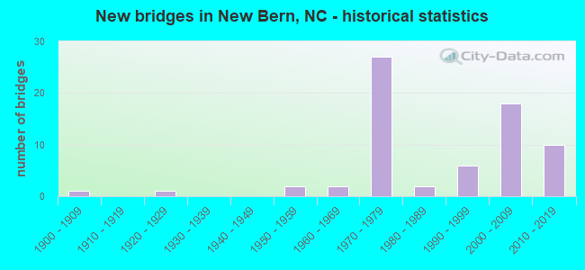
- New bridges - historical statistics
- 11900-1909
- 11920-1929
- 21950-1959
- 21960-1969
- 271970-1979
- 21980-1989
- 61990-1999
- 182000-2009
- 102010-2019
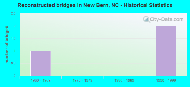
- Reconstructed bridges - Historical Statistics
- 11960-1969
- 01970-1979
- 01980-1989
- 21990-1999
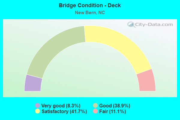
- Bridge Condition - Deck
- 8.3%Very good
- 38.9%Good
- 41.7%Satisfactory
- 11.1%Fair
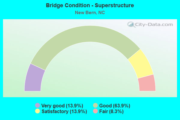
- Bridge Condition - Superstructure
- 13.9%Very good
- 63.9%Good
- 13.9%Satisfactory
- 8.3%Fair
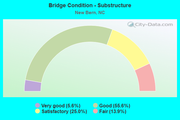
- Bridge Condition - Substructure
- 5.6%Very good
- 55.6%Good
- 25.0%Satisfactory
- 13.9%Fair
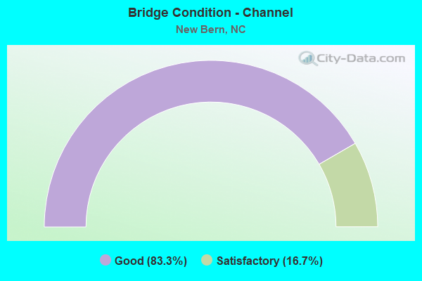
- Bridge Condition - Channel
- 83.3%Good
- 16.7%Satisfactory
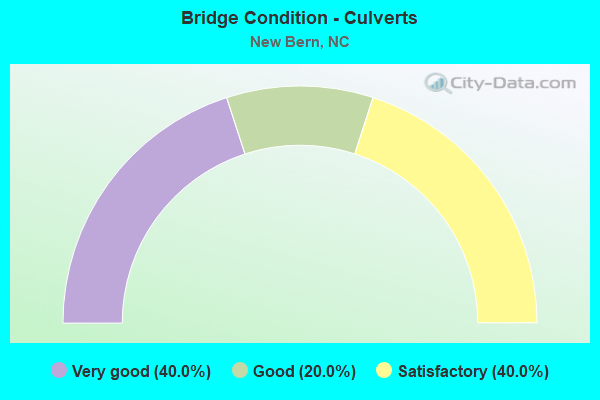
- Bridge Condition - Culverts
- 40.0%Very good
- 20.0%Good
- 40.0%Satisfactory
Find on map >> Show street view
Structure Number: 490001, Location: 0.9 MI.N. JCT.US17 (Lat: 35.112475, Lng: -77.097433), Route carried "under" structure: US 17, Year Built: 1976, Structure Length: 0. m, Average Daily Traffic: 15,500 (year 2019), Truck Traffic: 12%, Features Intersected: SR1309
Minimum Vertical Clearance: 5.20m (17.06ft), Kilometerpoint: 126.005, Lanes on structure: 5, Lanes under structure: 2, Material/Design: Steel continuous, Design/Construction: Stringer/Multi-beam, Length of Maximum Span: 34.4m (112.9ft)
Find on map >> Show street view
Structure Number: 490072, Location: 3.3 MI. N. JCT. SR1224 (Lat: 35.136686, Lng: -77.166844), Route carried "under" structure: US 70, Year Built: 1976, Structure Length: 0. m, Average Daily Traffic: 8,500 (year 2018), Truck Traffic: 14%, Features Intersected: SR1225
Minimum Vertical Clearance: 5.01m (16.44ft), Kilometerpoint: 12.192, Lanes on structure: 2, Lanes under structure: 2, Material/Design: Steel continuous, Design/Construction: Stringer/Multi-beam, Length of Maximum Span: 38.7m (127.0ft)
Find on map >> Show street view
Structure Number: 490072, Location: 3.3 MI. N. JCT. SR1224 (Lat: 35.136686, Lng: -77.166844), Route carried "under" structure: US 70, Year Built: 1976, Structure Length: 0. m, Average Daily Traffic: 8,500 (year 2018), Truck Traffic: 14%, Features Intersected: SR1225
Minimum Vertical Clearance: 5.05m (16.57ft), Kilometerpoint: 124.664, Lanes on structure: 2, Lanes under structure: 2, Material/Design: Steel continuous, Design/Construction: Stringer/Multi-beam, Length of Maximum Span: 38.7m (127.0ft)
Find on map >> Show street view
Structure Number: 490075, Location: 0.9 BYP. E. JCT. NC43 (Lat: 35.103917, Lng: -77.084392), Route carried "under" structure: US 17, Year Built: 1977, Structure Length: 0. m, Average Daily Traffic: 17,000 (year 2018), Truck Traffic: 12%, Features Intersected: US70E
Minimum Vertical Clearance: 5.13m (16.83ft), Kilometerpoint: 0.000, Lanes on structure: 2, Lanes under structure: 3, Material/Design: Steel, Design/Construction: Stringer/Multi-beam, Length of Maximum Span: 48.1m (157.8ft)
Find on map >> Show street view
Structure Number: 490075, Location: 0.9 BYP. E. JCT. NC43 (Lat: 35.103917, Lng: -77.084392), Route carried "under" structure: US 17, Year Built: 1977, Structure Length: 0. m, Average Daily Traffic: 17,000 (year 2018), Truck Traffic: 12%, Features Intersected: US70E
Minimum Vertical Clearance: 5.05m (16.57ft), Kilometerpoint: 0.000, Lanes on structure: 2, Lanes under structure: 5, Material/Design: Steel, Design/Construction: Stringer/Multi-beam, Length of Maximum Span: 48.1m (157.8ft)
Find on map >> Show street view
Structure Number: 490076, Location: 0.9 MI. E. JCT.NC 43 (Lat: 35.104036, Lng: -77.084067), Route carried "under" structure: US 17, Year Built: 1977, Structure Length: 0. m, Average Daily Traffic: 18,000 (year 2018), Truck Traffic: 14%, Features Intersected: US70W
Minimum Vertical Clearance: 5.00m (16.40ft), Kilometerpoint: 0.000, Lanes on structure: 2, Lanes under structure: 3, Material/Design: Steel, Design/Construction: Stringer/Multi-beam, Length of Maximum Span: 48.1m (157.8ft)
Find on map >> Show street view
Structure Number: 490076, Location: 0.9 MI. E. JCT.NC 43 (Lat: 35.104036, Lng: -77.084067), Route carried "under" structure: US 17, Year Built: 1977, Structure Length: 0. m, Average Daily Traffic: 18,000 (year 2018), Truck Traffic: 14%, Features Intersected: US70W
Minimum Vertical Clearance: 5.10m (16.73ft), Kilometerpoint: 0.000, Lanes on structure: 2, Lanes under structure: 5, Material/Design: Steel, Design/Construction: Stringer/Multi-beam, Length of Maximum Span: 48.1m (157.8ft)
Find on map >> Show street view
Structure Number: 490077, Location: 0.1 MI. W. JCT. SR1278 (Lat: 35.101667, Lng: -77.081025), Route carried "under" structure: Other road , Year Built: 1977, Structure Length: 0. m, Average Daily Traffic: 50 (year 2010), Truck Traffic: 6%, Features Intersected: US17N,US70E, Facility Carried by Structure: SERVICE RD
Minimum Vertical Clearance: 7.39m (24.25ft), Kilometerpoint: 0.000, Lanes on structure: 3, Lanes under structure: 2, Material/Design: Steel, Design/Construction: Stringer/Multi-beam, Length of Maximum Span: 19.5m (64.0ft)
Find on map >> Show street view
Structure Number: 490078, Location: 0.1 MI. W. JCT. SR1278 (Lat: 35.101714, Lng: -77.080542), Route carried "under" structure: Other road , Year Built: 1977, Structure Length: 0. m, Average Daily Traffic: 50 (year 2010), Truck Traffic: 7%, Features Intersected: US17S,US70W, Facility Carried by Structure: SERVICERD.
Minimum Vertical Clearance: 7.11m (23.33ft), Kilometerpoint: 0.000, Lanes on structure: 3, Lanes under structure: 2, Material/Design: Steel, Design/Construction: Stringer/Multi-beam, Length of Maximum Span: 19.5m (64.0ft)
Find on map >> Show street view
Structure Number: 490079, Location: 1.2 MI. W. OF JCT.SR1200 (Lat: 35.100139, Lng: -77.078217), Route carried "under" structure: State highway 1278, Year Built: 1977, Structure Length: 0. m, Average Daily Traffic: 11,000 (year 2016), Truck Traffic: 6%, Features Intersected: US17,US70E
Minimum Vertical Clearance: 6.07m (19.91ft), Kilometerpoint: 0.000, Lanes on structure: 2, Lanes under structure: 3, Material/Design: Steel, Design/Construction: Stringer/Multi-beam, Length of Maximum Span: 32.3m (106.0ft)
Find on map >> Show street view
Structure Number: 49008, Location: 1.2 MI. W. OF JCT. SR1200 (Lat: 35.100328, Lng: -77.077983), Route carried "under" structure: State highway 1278, Year Built: 1977, Structure Length: 0. m, Average Daily Traffic: 9,200 (year 2018), Truck Traffic: 6%, Features Intersected: US17,US70W
Minimum Vertical Clearance: 5.13m (16.83ft), Kilometerpoint: 0.000, Lanes on structure: 2, Lanes under structure: 3, Material/Design: Steel, Design/Construction: Stringer/Multi-beam, Length of Maximum Span: 32.3m (106.0ft)
Find on map >> Show street view
Structure Number: 490082, Location: 1.5 MI. N. JCT. SR1395 (Lat: 35.100928, Lng: -77.058778), Route carried "under" structure: US 17, Year Built: 1976, Structure Length: 0. m, Average Daily Traffic: 27,000 (year 2017), Truck Traffic: 12%, Features Intersected: SR1200
Minimum Vertical Clearance: 5.20m (17.06ft), Kilometerpoint: 126.767, Lanes on structure: 4, Lanes under structure: 2, Material/Design: Steel, Design/Construction: Stringer/Multi-beam, Length of Maximum Span: 31.0m (101.7ft)
Find on map >> Show street view
Structure Number: 490082, Location: 1.5 MI. N. JCT. SR1395 (Lat: 35.100928, Lng: -77.058778), Route carried "under" structure: US 17, Year Built: 1976, Structure Length: 0. m, Average Daily Traffic: 27,000 (year 2017), Truck Traffic: 12%, Features Intersected: SR1200
Minimum Vertical Clearance: 6.26m (20.54ft), Kilometerpoint: 126.767, Lanes on structure: 4, Lanes under structure: 3, Material/Design: Steel, Design/Construction: Stringer/Multi-beam, Length of Maximum Span: 31.0m (101.7ft)
Find on map >> Show street view
Structure Number: 490231, Location: JCT.US17-US70 & NEUS (Lat: 35.097219, Lng: -77.025719), Route carried "under" structure: US 70, Year Built: 2003, Structure Length: 0. m, Average Daily Traffic: 25,250 (year 2019), Truck Traffic: 12%, Features Intersected: US17,NC55
Minimum Vertical Clearance: 5.94m (19.49ft), Kilometerpoint: 0.000, Lanes on structure: 4, Lanes under structure: 2, Material/Design: Steel continuous, Design/Construction: Stringer/Multi-beam, Length of Maximum Span: 79.8m (261.8ft)
Find on map >> Show street view
Structure Number: 490231, Location: JCT.US17-US70 & NEUS (Lat: 35.097219, Lng: -77.025719), Route carried "under" structure: US 70, Year Built: 2003, Structure Length: 0. m, Average Daily Traffic: 25,250 (year 2019), Truck Traffic: 12%, Features Intersected: US17,NC55
Minimum Vertical Clearance: 5.56m (18.24ft), Kilometerpoint: 0.000, Lanes on structure: 4, Lanes under structure: 2, Material/Design: Steel continuous, Design/Construction: Stringer/Multi-beam, Length of Maximum Span: 79.8m (261.8ft)
Find on map >> Show street view
Structure Number: 490231, Location: JCT.US17-US70 & NEUS (Lat: 35.097219, Lng: -77.025719), Route carried "under" structure: State highway 1004, Year Built: 2003, Structure Length: 0. m, Average Daily Traffic: 7,000 (year 2019), Truck Traffic: 6%, Features Intersected: US17,NC55
Minimum Vertical Clearance: 14.68m (48.16ft), Kilometerpoint: 0.000, Lanes on structure: 4, Lanes under structure: 2, Material/Design: Steel continuous, Design/Construction: Stringer/Multi-beam, Length of Maximum Span: 79.8m (261.8ft)
Find on map >> Show street view
Structure Number: 490231, Location: JCT.US17-US70 & NEUS (Lat: 35.097219, Lng: -77.025719), Route carried "under" structure: Business US 70, Year Built: 2003, Structure Length: 0. m, Average Daily Traffic: 11,000 (year 2019), Truck Traffic: 12%, Features Intersected: US17,NC55
Minimum Vertical Clearance: 5.84m (19.16ft), Kilometerpoint: 0.000, Lanes on structure: 4, Lanes under structure: 2, Material/Design: Steel continuous, Design/Construction: Stringer/Multi-beam, Length of Maximum Span: 79.8m (261.8ft)
Find on map >> Show street view
Structure Number: 490231, Location: JCT.US17-US70 & NEUS (Lat: 35.097219, Lng: -77.025719), Route carried "under" structure: US 70, Year Built: 2003, Structure Length: 0. m, Average Daily Traffic: 25,250 (year 2019), Truck Traffic: 12%, Features Intersected: US17,NC55
Minimum Vertical Clearance: 15.74m (51.64ft), Kilometerpoint: 0.000, Lanes on structure: 4, Lanes under structure: 2, Material/Design: Steel continuous, Design/Construction: Stringer/Multi-beam, Length of Maximum Span: 79.8m (261.8ft)
Find on map >> Show street view
Structure Number: 490231, Location: JCT.US17-US70 & NEUS (Lat: 35.097219, Lng: -77.025719), Route carried "under" structure: Ramp US 17, Year Built: 2003, Structure Length: 0. m, Average Daily Traffic: 25,250 (year 2019), Truck Traffic: 12%, Features Intersected: US17,NC55
Minimum Vertical Clearance: 15.08m (49.48ft), Kilometerpoint: 0.000, Lanes on structure: 4, Lanes under structure: 2, Material/Design: Steel continuous, Design/Construction: Stringer/Multi-beam, Length of Maximum Span: 79.8m (261.8ft)
Find on map >> Show street view
Structure Number: 490256, Location: 2.0 MI.S.JCT.NC55 (Lat: 35.126703, Lng: -77.133697), Route carried "under" structure: US 70, Year Built: 2009, Structure Length: 0. m, Average Daily Traffic: 8,500 (year 2015), Truck Traffic: 14%, Features Intersected: NC43N.BYP. N
Minimum Vertical Clearance: 5.66m (18.57ft), Kilometerpoint: 125.274, Lanes on structure: 2, Lanes under structure: 3, Material/Design: Prestressed concrete continuous, Design/Construction: Stringer/Multi-beam, Length of Maximum Span: 29.8m (97.8ft)
Find on map >> Show street view
Structure Number: 490256, Location: 2.0 MI.S.JCT.NC55 (Lat: 35.126703, Lng: -77.133697), Route carried "under" structure: US 70, Year Built: 2009, Structure Length: 0. m, Average Daily Traffic: 8,500 (year 2015), Truck Traffic: 14%, Features Intersected: NC43N.BYP. N
Minimum Vertical Clearance: 5.48m (17.98ft), Kilometerpoint: 125.274, Lanes on structure: 2, Lanes under structure: 2, Material/Design: Prestressed concrete continuous, Design/Construction: Stringer/Multi-beam, Length of Maximum Span: 29.8m (97.8ft)
Find on map >> Show street view
Structure Number: 490257, Location: 2.0 MI.S.JCT.NC55 (Lat: 35.126778, Lng: -77.133944), Route carried "under" structure: US 70, Year Built: 2009, Structure Length: 0. m, Average Daily Traffic: 10,500 (year 2015), Truck Traffic: 12%, Features Intersected: NC43S CONN.
Minimum Vertical Clearance: 5.48m (17.98ft), Kilometerpoint: 125.274, Lanes on structure: 2, Lanes under structure: 3, Material/Design: Prestressed concrete continuous, Design/Construction: Stringer/Multi-beam, Length of Maximum Span: 29.8m (97.8ft)
Find on map >> Show street view
Structure Number: 490257, Location: 2.0 MI.S.JCT.NC55 (Lat: 35.126778, Lng: -77.133944), Route carried "under" structure: US 70, Year Built: 2009, Structure Length: 0. m, Average Daily Traffic: 10,500 (year 2015), Truck Traffic: 12%, Features Intersected: NC43S CONN.
Minimum Vertical Clearance: 5.46m (17.91ft), Kilometerpoint: 125.274, Lanes on structure: 2, Lanes under structure: 2, Material/Design: Prestressed concrete continuous, Design/Construction: Stringer/Multi-beam, Length of Maximum Span: 29.8m (97.8ft)
Find on map >> Show street view
Structure Number: 490262, Location: 5.2MI.N.JCT.US17 BUS (Lat: 35.132161, Lng: -77.151789), Route carried "under" structure: US 70, Year Built: 2011, Structure Length: 0. m, Average Daily Traffic: 9,500 (year 2019), Truck Traffic: 14%, Features Intersected: US17S
Minimum Vertical Clearance: 5.56m (18.24ft), Kilometerpoint: 124.969, Lanes on structure: 3, Lanes under structure: 3, Material/Design: Steel continuous, Design/Construction: Stringer/Multi-beam, Length of Maximum Span: 37.4m (122.7ft)
Find on map >> Show street view
Structure Number: 490262, Location: 5.2MI.N.JCT.US17 BUS (Lat: 35.132161, Lng: -77.151789), Route carried "under" structure: US 70, Year Built: 2011, Structure Length: 0. m, Average Daily Traffic: 9,500 (year 2019), Truck Traffic: 14%, Features Intersected: US17S
Minimum Vertical Clearance: 5.53m (18.14ft), Kilometerpoint: 124.969, Lanes on structure: 3, Lanes under structure: 2, Material/Design: Steel continuous, Design/Construction: Stringer/Multi-beam, Length of Maximum Span: 37.4m (122.7ft)
Find on map >> Show street view
Structure Number: 490263, Location: 5.2 MI.N.JCT.US17 BUS (Lat: 35.132094, Lng: -77.151569), Route carried "under" structure: US 70, Year Built: 2011, Structure Length: 0. m, Average Daily Traffic: 9,500 (year 2019), Truck Traffic: 14%, Features Intersected: US17N
Minimum Vertical Clearance: 5.53m (18.14ft), Kilometerpoint: 124.969, Lanes on structure: 2, Lanes under structure: 3, Material/Design: Steel continuous, Design/Construction: Stringer/Multi-beam, Length of Maximum Span: 37.4m (122.7ft)
Find on map >> Show street view
Structure Number: 490263, Location: 5.2 MI.N.JCT.US17 BUS (Lat: 35.132094, Lng: -77.151569), Route carried "under" structure: US 70, Year Built: 2011, Structure Length: 0. m, Average Daily Traffic: 9,500 (year 2019), Truck Traffic: 14%, Features Intersected: US17N
Minimum Vertical Clearance: 5.51m (18.08ft), Kilometerpoint: 124.969, Lanes on structure: 2, Lanes under structure: 2, Material/Design: Steel continuous, Design/Construction: Stringer/Multi-beam, Length of Maximum Span: 37.4m (122.7ft)