Bridge Statistics for New Douglas, Illinois (IL)
Condition, Traffic, Stress, Structural Evaluation, Project Costs
- National Bridge Inventory (NBI) Statistics
- 11Number of bridges
- 59ft / 18.3mTotal length
- $26,000Total costs
- 1,100Total average daily traffic
- 161Total average daily truck traffic
- National Bridge Inventory (NBI) Registered Bridges for New Douglas
- No street view available for this location
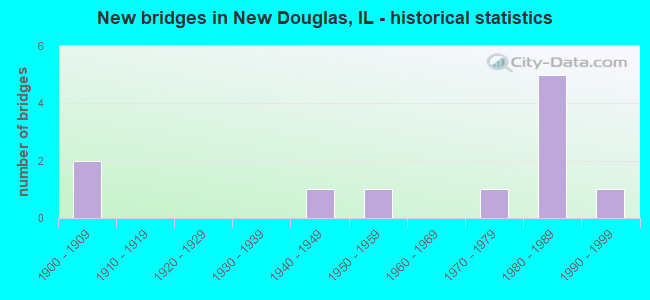
- New bridges - historical statistics
- 21900-1909
- 11940-1949
- 11950-1959
- 11970-1979
- 51980-1989
- 11990-1999
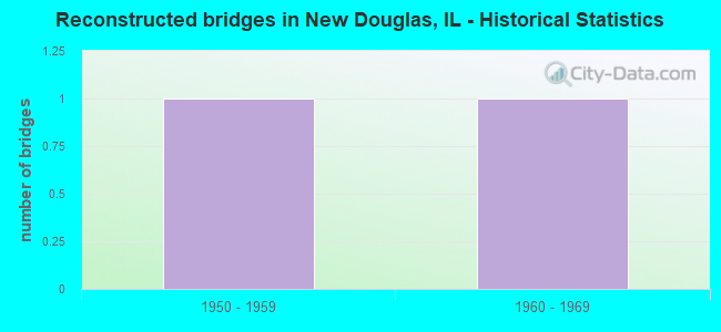
- Reconstructed bridges - Historical Statistics
- 11950-1959
- 11960-1969
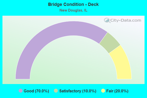
- Bridge Condition - Deck
- 70.0%Good
- 10.0%Satisfactory
- 20.0%Fair
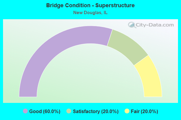
- Bridge Condition - Superstructure
- 60.0%Good
- 20.0%Satisfactory
- 20.0%Fair
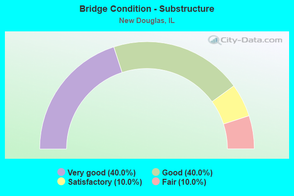
- Bridge Condition - Substructure
- 40.0%Very good
- 40.0%Good
- 10.0%Satisfactory
- 10.0%Fair
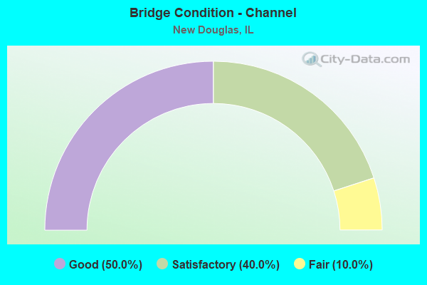
- Bridge Condition - Channel
- 50.0%Good
- 40.0%Satisfactory
- 10.0%Fair
Find on map >> Show street view
Structure Number: 33821, Location: 4.5M NW OLD RIPLEY (Lat: 38.952053, Lng: -89.632131), Route carried "on" structure: County highway , Year Built: 1981, Status: Open, Structure Length: 1.34m (4.40ft), Average Daily Traffic: 75 (year 2020), Truck Traffic: 20%, Average Future Daily Traffic: 105 (year 2032), Design Load: HS 20, Features Intersected: LITTLE DRYFORK, Facility Carried by Structure: TR 61
Minimum Vertical Clearance: 30+ m (98+ ft), Kilometerpoint: 0.821, Lanes on structure: 2, Owner: Town or Township Highway Agency, Approaching Roadway Width: 8.5m (27.9ft), Skew: 2 degrees, Material/Design: Prestressed concrete, Design/Construction: Box Beam or Girders - Multiple, Number Of Spans In Main Unit: 1, Length of Maximum Span: 13.4m (44.0ft), Curb-To-Curb Width: 8.1m (26.6ft), Out-to-Out Width: 8.3m (27.2ft)
Condition: Deck: Good, Superstructure: Good, Substructure: Very good, Channel: Good, Operating Rating: 44.1 metric tons, Method Used To Determine Operating Rating: Assigned rating based on Load Factor Design (LFD) reported by rating factor (RF) using MS18 loading, Inventory Rating: 32.4 metric tons, Method Used To Determine Inventory Rating: Assigned rating based on Load Factor Design (LFD) reported by rating factor (RF) using MS18 loading, Structural Evaluation: Better than present minimum criteria, Deck Geometry: Equal to present minimum criteria, Waterway Adequacy: Better than present minimum criteria, Approach Roadway Alignment: Equal to present desirable criteria, Designated Inspection Frequency: Every 24 months, Inspection Date: December 2021, Deck Structure Type: Concrete Precast Panels
Find on map >> Show street view
Structure Number: 33824, Location: 2.5 MI NW OLD RIPLEY (Lat: 38.923639, Lng: -89.623417), Route carried "on" structure: County highway , Year Built: 1985, Status: Open, Structure Length: 1.04m (3.41ft), Average Daily Traffic: 225 (year 2020), Truck Traffic: 22%, Average Future Daily Traffic: 237 (year 2032), Design Load: HS 20, Features Intersected: TRIB TO LITTLE DRY F, Facility Carried by Structure: TR 8
Minimum Vertical Clearance: 30+ m (98+ ft), Kilometerpoint: 1.078, Lanes on structure: 2, Owner: Town or Township Highway Agency, Approaching Roadway Width: 8.5m (27.9ft), Skew: 2 degrees, Material/Design: Prestressed concrete, Design/Construction: Box Beam or Girders - Multiple, Number Of Spans In Main Unit: 1, Length of Maximum Span: 10.4m (34.1ft), Curb-To-Curb Width: 8.0m (26.2ft), Out-to-Out Width: 8.2m (26.9ft)
Condition: Deck: Good, Superstructure: Good, Substructure: Good, Channel: Satisfactory, Operating Rating: 61.6 metric tons, Method Used To Determine Operating Rating: Load Factor (LF) rating reported by rating factor (RF) method using MS18 loading, Inventory Rating: 36.9 metric tons, Method Used To Determine Inventory Rating: Load Factor (LF) rating reported by rating factor (RF) method using MS18 loading, Structural Evaluation: Better than present minimum criteria, Deck Geometry: Somewhat better than minimum adequacy, Waterway Adequacy: Equal to present desirable criteria, Approach Roadway Alignment: Equal to present desirable criteria, Designated Inspection Frequency: Every 24 months, Inspection Date: December 2021, Deck Structure Type: Concrete Precast Panels
Find on map >> Show street view
Structure Number: 593223, Location: 3.5 M E STAUNTON (Lat: 39.001119, Lng: -89.707067), Route carried "on" structure: County highway , Year Built: 1956, Status: Open, Structure Length: 1.07m (3.51ft), Average Daily Traffic: 250 (year 2021), Truck Traffic: 13%, Average Future Daily Traffic: 252 (year 2032), Design Load: HS 15, Features Intersected: SILVER CREEK, Facility Carried by Structure: TR 483
Minimum Vertical Clearance: 30+ m (98+ ft), Kilometerpoint: 5.874, Lanes on structure: 2, Owner: Town or Township Highway Agency, Approaching Roadway Width: 4.6m (15.1ft), Material/Design: Prestressed concrete, Design/Construction: Box Beam or Girders - Multiple, Number Of Spans In Main Unit: 1, Length of Maximum Span: 10.4m (34.1ft), Curb-To-Curb Width: 6.1m (20.0ft), Out-to-Out Width: 6.4m (21.0ft)
Condition: Deck: Fair, Superstructure: Fair, Substructure: Good, Channel: Good, Operating Rating: 55.7 metric tons, Method Used To Determine Operating Rating: Load Factor (LF) rating reported by rating factor (RF) method using MS18 loading, Inventory Rating: 33.4 metric tons, Method Used To Determine Inventory Rating: Load Factor (LF) rating reported by rating factor (RF) method using MS18 loading, Structural Evaluation: Somewhat better than minimum adequacy, Deck Geometry: Meets minimum limits, Waterway Adequacy: Better than present minimum criteria, Approach Roadway Alignment: Equal to present minimum criteria, Designated Inspection Frequency: Every 24 months, Inspection Date: January 2021, Deck Structure Type: Concrete Precast Panels, Wearing Surface/Protective System: Wearing Surface: Gravel
Find on map >> Show street view
Structure Number: 603218, Location: 2.5 MI E OF LIVINGST (Lat: 38.965594, Lng: -89.707769), Route carried "on" structure: County highway , Year Built: 1901, Year Reconstructed: 1969, Status: Posted for load, Structure Length: 1.23m (4.04ft), Average Future Daily Traffic: 11 (year 2032), Design Load: H 15, Features Intersected: SILVER CREEK, Facility Carried by Structure: NIEHAUS RD/ TR 326
Minimum Vertical Clearance: 30+ m (98+ ft), Kilometerpoint: 2.382, Lanes on structure: 1, Owner: Town or Township Highway Agency, Approaching Roadway Width: 3.4m (11.2ft), Material/Design: Steel, Design/Construction: Stringer/Multi-beam, Number Of Spans In Main Unit: 1, Length of Maximum Span: 11.9m (39.0ft), Curb-To-Curb Width: 3.3m (10.8ft), Out-to-Out Width: 3.7m (12.1ft)
Condition: Deck: Good, Superstructure: Satisfactory, Substructure: Good, Channel: Good, Operating Rating: 31.8 metric tons, Method Used To Determine Operating Rating: Load Factor (LF) rating reported by rating factor (RF) method using MS18 loading, Inventory Rating: 19.1 metric tons, Method Used To Determine Inventory Rating: Load Factor (LF) rating reported by rating factor (RF) method using MS18 loading, Structural Evaluation: Somewhat better than minimum adequacy, Deck Geometry: High priority of replacement, Waterway Adequacy: Equal to present desirable criteria, Approach Roadway Alignment: Equal to present minimum criteria, Bridge Posting: Required (Relationship of Operating Rating to Maximum Legal Load: 30.0 - 39.9% below), Length Of Structure Improvement: 1.25m (4.10ft), Designated Inspection Frequency: Every 24 months, Inspection Date: May 2021, Bridge Improvement Cost: $24,000, Roadway Improvement Cost: $2,000, Total Project Cost: $26,000, Deck Structure Type: Wood or Timber, Wearing Surface/Protective System: Wearing Surface: Wood or Timber
Find on map >> Show street view
Structure Number: 603242, Location: 2.0 MI SE N DOUGLAS (Lat: 38.933236, Lng: -89.639089), Route carried "on" structure: County highway , Year Built: 1979, Status: Open, Structure Length: 1.01m (3.31ft), Average Daily Traffic: 50 (year 2021), Truck Traffic: 20%, Average Future Daily Traffic: 53 (year 2032), Design Load: HS 20, Features Intersected: TRIB TO L DRY FORK, Facility Carried by Structure: BLACKSMITH RD/TR 1
Minimum Vertical Clearance: 30+ m (98+ ft), Kilometerpoint: 0.724, Lanes on structure: 2, Owner: Town or Township Highway Agency, Approaching Roadway Width: 5.2m (17.1ft), Skew: 2 degrees, Material/Design: Prestressed concrete, Design/Construction: Box Beam or Girders - Multiple, Number Of Spans In Main Unit: 1, Length of Maximum Span: 9.8m (32.2ft), Curb-To-Curb Width: 9.1m (29.9ft), Out-to-Out Width: 9.3m (30.5ft)
Condition: Deck: Good, Superstructure: Good, Substructure: Very good, Channel: Satisfactory, Operating Rating: 44.4 metric tons, Method Used To Determine Operating Rating: Assigned rating based on Load Factor Design (LFD) reported by rating factor (RF) using MS18 loading, Inventory Rating: 32.4 metric tons, Method Used To Determine Inventory Rating: Assigned rating based on Load Factor Design (LFD) reported by rating factor (RF) using MS18 loading, Structural Evaluation: Better than present minimum criteria, Deck Geometry: Better than present minimum criteria, Waterway Adequacy: Equal to present desirable criteria, Approach Roadway Alignment: Equal to present desirable criteria, Designated Inspection Frequency: Every 48 months, Inspection Date: June 2021, Deck Structure Type: Concrete Precast Panels, Wearing Surface/Protective System: Wearing Surface: Gravel
Find on map >> Show street view
Structure Number: 603248, Location: 0.25 MI EAST BINNEY (Lat: 38.989925, Lng: -89.712292), Route carried "on" structure: County highway , Year Built: 1981, Status: Open, Structure Length: 5.67m (18.60ft), Average Daily Traffic: 100 (year 2021), Truck Traffic: 9%, Average Future Daily Traffic: 80 (year 2032), Design Load: HS 20, Features Intersected: SILVER CK, Facility Carried by Structure: TR 17
Minimum Vertical Clearance: 30+ m (98+ ft), Kilometerpoint: 1.658, Lanes on structure: 2, Owner: Town or Township Highway Agency, Approaching Roadway Width: 6.4m (21.0ft), Skew: 3 degrees, Material/Design: Prestressed concrete, Design/Construction: Box Beam or Girders - Multiple, Number Of Spans In Main Unit: 3, Length of Maximum Span: 18.6m (61.0ft), Curb-To-Curb Width: 9.2m (30.2ft), Out-to-Out Width: 9.3m (30.5ft)
Condition: Deck: Satisfactory, Superstructure: Satisfactory, Substructure: Fair, Channel: Fair, Operating Rating: 44.4 metric tons, Method Used To Determine Operating Rating: Assigned rating based on Load Factor Design (LFD) reported by rating factor (RF) using MS18 loading, Inventory Rating: 32.4 metric tons, Method Used To Determine Inventory Rating: Assigned rating based on Load Factor Design (LFD) reported by rating factor (RF) using MS18 loading, Structural Evaluation: Somewhat better than minimum adequacy, Deck Geometry: Better than present minimum criteria, Waterway Adequacy: Equal to present minimum criteria, Approach Roadway Alignment: Equal to present desirable criteria, Designated Inspection Frequency: Every 24 months, Inspection Date: May 2021, Deck Structure Type: Concrete Precast Panels, Wearing Surface/Protective System: Wearing Surface: Gravel
Find on map >> Show street view
Structure Number: 603288, Location: 3 MI SE NEW DOUGLAS (Lat: 38.932811, Lng: -89.637950), Route carried "on" structure: County highway , Year Built: 1986, Status: Open, Structure Length: 1.04m (3.41ft), Average Daily Traffic: 25 (year 2020), Truck Traffic: 16%, Average Future Daily Traffic: 11 (year 2032), Design Load: HS 20, Features Intersected: TRIBUTARY, Facility Carried by Structure: BOND COUNTY TR 6
Minimum Vertical Clearance: 30+ m (98+ ft), Kilometerpoint: 0.048, Lanes on structure: 2, Owner: County Highway Agency, Approaching Roadway Width: 7.6m (24.9ft), Material/Design: Prestressed concrete, Design/Construction: Box Beam or Girders - Multiple, Number Of Spans In Main Unit: 1, Length of Maximum Span: 10.4m (34.1ft), Curb-To-Curb Width: 8.9m (29.2ft), Out-to-Out Width: 9.1m (29.9ft)
Condition: Deck: Good, Superstructure: Good, Substructure: Good, Channel: Satisfactory, Operating Rating: 44.4 metric tons, Method Used To Determine Operating Rating: Assigned rating based on Load Factor Design (LFD) reported by rating factor (RF) using MS18 loading, Inventory Rating: 32.4 metric tons, Method Used To Determine Inventory Rating: Assigned rating based on Load Factor Design (LFD) reported by rating factor (RF) using MS18 loading, Structural Evaluation: Better than present minimum criteria, Deck Geometry: Better than present minimum criteria, Waterway Adequacy: Equal to present desirable criteria, Approach Roadway Alignment: Better than present minimum criteria, Designated Inspection Frequency: Every 48 months, Inspection Date: June 2021, Deck Structure Type: Concrete Precast Panels, Wearing Surface/Protective System: Wearing Surface: Gravel
Find on map >> Show street view
Structure Number: 603289, Location: 4.5 MI NE ALHAMBRA (Lat: 38.903447, Lng: -89.649808), Route carried "on" structure: County highway , Year Built: 1988, Status: Open, Structure Length: 1.89m (6.20ft), Average Daily Traffic: 50 (year 2021), Truck Traffic: 6%, Average Future Daily Traffic: 27 (year 2032), Design Load: HS 20, Features Intersected: LITTLE SILVER CREEK, Facility Carried by Structure: TR 145
Minimum Vertical Clearance: 30+ m (98+ ft), Kilometerpoint: 8.706, Lanes on structure: 2, Owner: Town or Township Highway Agency, Approaching Roadway Width: 6.4m (21.0ft), Material/Design: Prestressed concrete, Design/Construction: Box Beam or Girders - Multiple, Number Of Spans In Main Unit: 1, Length of Maximum Span: 18.0m (59.1ft), Curb-To-Curb Width: 8.7m (28.5ft), Out-to-Out Width: 8.7m (28.5ft)
Condition: Deck: Good, Superstructure: Good, Substructure: Very good, Channel: Good, Operating Rating: 44.4 metric tons, Method Used To Determine Operating Rating: Assigned rating based on Load Factor Design (LFD) reported by rating factor (RF) using MS18 loading, Inventory Rating: 32.4 metric tons, Method Used To Determine Inventory Rating: Assigned rating based on Load Factor Design (LFD) reported by rating factor (RF) using MS18 loading, Structural Evaluation: Better than present minimum criteria, Deck Geometry: Better than present minimum criteria, Waterway Adequacy: Equal to present desirable criteria, Approach Roadway Alignment: Equal to present desirable criteria, Designated Inspection Frequency: Every 48 months, Inspection Date: December 2021, Deck Structure Type: Concrete Precast Panels, Wearing Surface/Protective System: Wearing Surface: Gravel
Find on map >> Show street view
Structure Number: 603313, Location: 1.5 MI N NEW DOUGLAS (Lat: 38.999108, Lng: -89.660078), Route carried "on" structure: County highway , Year Built: 1994, Status: Open, Structure Length: 1.87m (6.14ft), Average Daily Traffic: 50 (year 2021), Truck Traffic: 14%, Average Future Daily Traffic: 27 (year 2032), Design Load: HS 20, Features Intersected: TRIB TO DRY FORK CK, Facility Carried by Structure: TR 9
Minimum Vertical Clearance: 30+ m (98+ ft), Kilometerpoint: 2.189, Lanes on structure: 2, Owner: County Highway Agency, Approaching Roadway Width: 5.6m (18.4ft), Material/Design: Prestressed concrete, Design/Construction: Box Beam or Girders - Multiple, Number Of Spans In Main Unit: 1, Length of Maximum Span: 18.0m (59.1ft), Curb-To-Curb Width: 8.6m (28.2ft), Out-to-Out Width: 8.6m (28.2ft)
Condition: Deck: Good, Superstructure: Good, Substructure: Very good, Channel: Satisfactory, Operating Rating: 44.1 metric tons, Method Used To Determine Operating Rating: Assigned rating based on Load Factor Design (LFD) reported by rating factor (RF) using MS18 loading, Inventory Rating: 32.4 metric tons, Method Used To Determine Inventory Rating: Assigned rating based on Load Factor Design (LFD) reported by rating factor (RF) using MS18 loading, Structural Evaluation: Better than present minimum criteria, Deck Geometry: Better than present minimum criteria, Waterway Adequacy: Equal to present desirable criteria, Approach Roadway Alignment: Equal to present desirable criteria, Designated Inspection Frequency: Every 48 months, Inspection Date: June 2021, Deck Structure Type: Concrete Precast Panels, Wearing Surface/Protective System: Wearing Surface: Gravel
Find on map >> Show street view
Structure Number: 683216, Location: 4.3 MI SW WALSHVILLE (Lat: 39.013753, Lng: -89.646672), Route carried "on" structure: County highway , Year Built: 1900, Year Reconstructed: 1964, Status: Open, Structure Length: 2.13m (6.99ft), Average Daily Traffic: 25 (year 2020), Average Future Daily Traffic: 27 (year 2032), Features Intersected: DRY FORK, Facility Carried by Structure: TR 0473
Minimum Vertical Clearance: 30+ m (98+ ft), Kilometerpoint: 3.267, Lanes on structure: 1, Owner: Town or Township Highway Agency, Approaching Roadway Width: 4.3m (14.1ft), Skew: 3 degrees, Material/Design: Prestressed concrete, Design/Construction: Box Beam or Girders - Multiple, Number Of Spans In Main Unit: 3, Length of Maximum Span: 8.5m (27.9ft), Curb-To-Curb Width: 5.5m (18.0ft), Out-to-Out Width: 5.6m (18.4ft)
Condition: Deck: Fair, Superstructure: Fair, Substructure: Satisfactory, Channel: Good, Operating Rating: 72.9 metric tons, Method Used To Determine Operating Rating: Load Factor (LF) rating reported by rating factor (RF) method using MS18 loading, Inventory Rating: 43.7 metric tons, Method Used To Determine Inventory Rating: Load Factor (LF) rating reported by rating factor (RF) method using MS18 loading, Structural Evaluation: Somewhat better than minimum adequacy, Deck Geometry: Meets minimum limits, Waterway Adequacy: Equal to present minimum criteria, Approach Roadway Alignment: Equal to present minimum criteria, Designated Inspection Frequency: Every 24 months, Inspection Date: November 2020, Deck Structure Type: Concrete Precast Panels, Wearing Surface/Protective System: Wearing Surface: Gravel
Find on map >> Show street view
Structure Number: 599912, Location: 2.5 M E STAUNTON (Lat: 39.001886, Lng: -89.708175), Route carried "under" structure: County highway , Year Built: 1944, Structure Length: 0. m, Average Daily Traffic: 250 (year 2021), Truck Traffic: 13%, Features Intersected: TR 438A, Facility Carried by Structure: UP RR
Minimum Vertical Clearance: 7.16m (23.49ft), Kilometerpoint: 5.745, Lanes under structure: 2, Material/Design: Concrete, Design/Construction: Arch - Deck, Length of Maximum Span: 15.8m (51.8ft)