Bridge Statistics for Nitro, West Virginia (WV)
Condition, Traffic, Stress, Structural Evaluation, Project Costs
- National Bridge Inventory (NBI) Statistics
- 15Number of bridges
- 230ft / 69.7mTotal length
- $4,150,000Total costs
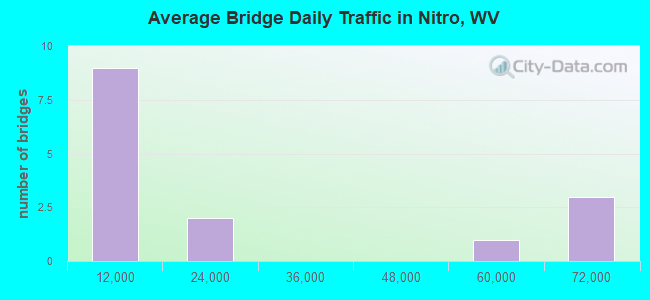
- 290,046Total average daily traffic
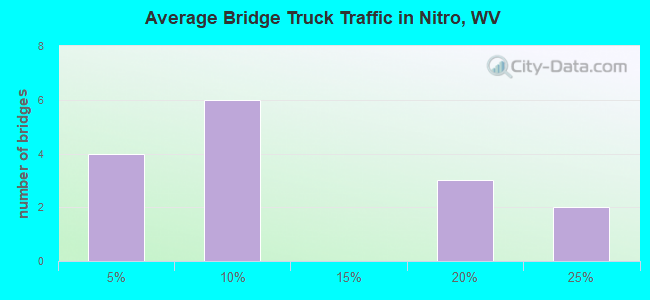
- 50,123Total average daily truck traffic
- National Bridge Inventory (NBI) Registered Bridges for Nitro
- No street view available for this location
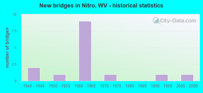
- New bridges - historical statistics
- 21940-1949
- 11950-1959
- 91960-1969
- 11970-1979
- 11990-1999
- 12000-2009
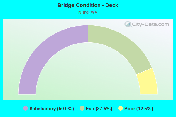
- Bridge Condition - Deck
- 50.0%Satisfactory
- 37.5%Fair
- 12.5%Poor
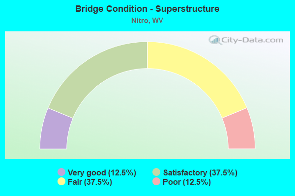
- Bridge Condition - Superstructure
- 12.5%Very good
- 37.5%Satisfactory
- 37.5%Fair
- 12.5%Poor
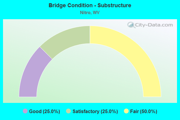
- Bridge Condition - Substructure
- 25.0%Good
- 25.0%Satisfactory
- 50.0%Fair
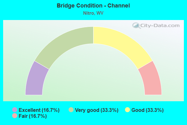
- Bridge Condition - Channel
- 16.7%Excellent
- 33.3%Very good
- 33.3%Good
- 16.7%Fair
Find on map >> Show street view
Structure Number: 20A069, Location: 0.17 MI E OF CR 25/10 (Lat: 38.385819, Lng: -81.769469), Route carried "on" structure: Ramp Interstate 64, Year Built: 1965, Status: Open, Structure Length: 4.55m (14.93ft), Average Daily Traffic: 68,700 (year 2018), Truck Traffic: 21%, Average Future Daily Traffic: 96,867 (year 2038), Design Load: HS 20, Features Intersected: WV25
Minimum Vertical Clearance: 30+ m (98+ ft), Kilometerpoint: 80.467, Lanes on structure: 1, Lanes under structure: 2, Owner: State Highway Agency, Approaching Roadway Width: 7.6m (24.9ft), Skew: 9 degrees, Material/Design: Steel continuous, Design/Construction: Stringer/Multi-beam, Number Of Spans In Main Unit: 1, Number Of Approach Spans: 3, Length of Maximum Span: 13.8m (45.3ft), Curb-To-Curb Width: 6.7m (22.0ft), Out-to-Out Width: 7.3m (24.0ft)
Condition: Deck: Poor, Superstructure: Poor, Substructure: Fair, Operating Rating: 55.3 metric tons, Method Used To Determine Operating Rating: Load Factor (LF), Inventory Rating: 32.7 metric tons, Method Used To Determine Inventory Rating: Load Factor (LF), Structural Evaluation: Meets minimum limits, Deck Geometry: Equal to present minimum criteria, Underclear: Meets minimum limits, Approach Roadway Alignment: Somewhat better than minimum adequacy, Length Of Structure Improvement: 4.55m (14.93ft), Designated Inspection Frequency: Every 24 months, Other Special Inspection Frequency: Every 12 months, Inspection Date: June 2020, Other Special Inspection Date: June 2021, Bridge Improvement Cost: $1,100,000, Roadway Improvement Cost: $300,000, Total Project Cost: $1,400,000 ( Estimate for 2020), Deck Structure Type: Concrete Cast-file-Place, Wearing Surface/Protective System: Wearing Surface: Bituminous
Find on map >> Show street view
Structure Number: 20A172, Location: 0.04 MI W OF US 60 (Lat: 38.396150, Lng: -81.859461), Route carried "on" structure: County highway 6014, Year Built: 1940, Status: Open, Structure Length: 0.68m (2.23ft), Average Daily Traffic: 5,300 (year 2018), Truck Traffic: 5%, Average Future Daily Traffic: 6,466 (year 2039), Features Intersected: TACKETT CREEK, Facility Carried by Structure: CR 60/14 SLS
Minimum Vertical Clearance: 30+ m (98+ ft), Kilometerpoint: 8.031, Lanes on structure: 2, Owner: State Highway Agency, Approaching Roadway Width: 5.5m (18.0ft), Skew: 1 degrees, Material/Design: Concrete, Design/Construction: Slab, Number Of Spans In Main Unit: 1, Length of Maximum Span: 6.4m (21.0ft), Curb-To-Curb Width: 7.4m (24.3ft), Out-to-Out Width: 7.8m (25.6ft)
Condition: Deck: Fair, Superstructure: Fair, Substructure: Fair, Channel: Fair, Operating Rating: 47.2 metric tons, Method Used To Determine Operating Rating: Field evaluation and documented engineering judgment, Inventory Rating: 21.8 metric tons, Method Used To Determine Inventory Rating: Field evaluation and documented engineering judgment, Structural Evaluation: Somewhat better than minimum adequacy, Deck Geometry: High priority of replacement, Waterway Adequacy: Somewhat better than minimum adequacy, Approach Roadway Alignment: Equal to present desirable criteria, Length Of Structure Improvement: 0.68m (2.23ft), Designated Inspection Frequency: Every 24 months, Inspection Date: September 2020, Bridge Improvement Cost: $150,000, Roadway Improvement Cost: $50,000, Total Project Cost: $200,000 ( Estimate for 2020), Deck Structure Type: Concrete Cast-file-Place, Wearing Surface/Protective System: Wearing Surface: Bituminous
Find on map >> Show street view
Structure Number: 20A714, Location: 0.01 MI S OF CR 35/1 (Lat: 38.429889, Lng: -81.828531), Route carried "on" structure: County highway 357, Year Built: 1972, Status: Open, Structure Length: 0.98m (3.22ft), Average Daily Traffic: 50 (year 2019), Truck Traffic: 5%, Average Future Daily Traffic: 61 (year 2039), Features Intersected: ARMOUR CREEK, Facility Carried by Structure: COUNTY ROUTE 35/7
Minimum Vertical Clearance: 30+ m (98+ ft), Kilometerpoint: 0.016, Lanes on structure: 2, Owner: State Highway Agency, Approaching Roadway Width: 5.8m (19.0ft), Material/Design: Steel, Design/Construction: Culvert, Number Of Spans In Main Unit: 1, Number Of Approach Spans: 2, Length of Maximum Span: 2.9m (9.5ft)
Condition: Channel: Good, Culverts: Good, Operating Rating: 53.5 metric tons, Method Used To Determine Operating Rating: Field evaluation and documented engineering judgment, Inventory Rating: 24.5 metric tons, Method Used To Determine Inventory Rating: Field evaluation and documented engineering judgment, Structural Evaluation: Equal to present minimum criteria, Waterway Adequacy: Equal to present desirable criteria, Approach Roadway Alignment: Equal to present minimum criteria, Designated Inspection Frequency: Every 24 months, Inspection Date: June 2020
Find on map >> Show street view
Structure Number: 20A919, Location: 0.02 MI N OF CR 25\1 (Lat: 38.422189, Lng: -81.838519), Route carried "on" structure: County highway 2568, Year Built: 1950, Status: Posted for load, Structure Length: 0.77m (2.53ft), Average Daily Traffic: 100 (year 2018), Truck Traffic: 5%, Average Future Daily Traffic: 122 (year 2038), Features Intersected: BLAKE CREEK, Facility Carried by Structure: THIRD AVE
Minimum Vertical Clearance: 30+ m (98+ ft), Kilometerpoint: 0.064, Lanes on structure: 2, Owner: State Highway Agency, Approaching Roadway Width: 6.1m (20.0ft), Skew: 3 degrees, Material/Design: Concrete, Design/Construction: Slab, Number Of Spans In Main Unit: 1, Length of Maximum Span: 6.9m (22.6ft), Curb or Sidewalk Widths: Left: 0.9m (3.0ft), Right: 0.9m (3.0ft), Curb-To-Curb Width: 6.2m (20.3ft), Out-to-Out Width: 8.3m (27.2ft)
Condition: Deck: Satisfactory, Superstructure: Satisfactory, Substructure: Fair, Channel: Very good, Operating Rating: 20.0 metric tons, Method Used To Determine Operating Rating: Load Factor (LF), Inventory Rating: 11.8 metric tons, Method Used To Determine Inventory Rating: Load Factor (LF), Structural Evaluation: Meets minimum limits, Deck Geometry: Somewhat better than minimum adequacy, Waterway Adequacy: Better than present minimum criteria, Approach Roadway Alignment: Better than present minimum criteria, Bridge Posting: Required (Relationship of Operating Rating to Maximum Legal Load: > 39.9% below), Length Of Structure Improvement: 0.77m (2.53ft), Designated Inspection Frequency: Every 24 months, Inspection Date: Febuary 2021, Bridge Improvement Cost: $450,000, Roadway Improvement Cost: $50,000, Total Project Cost: $500,000 ( Estimate for 2021), Deck Structure Type: Concrete Cast-file-Place, Wearing Surface/Protective System: Wearing Surface: Bituminous
Find on map >> Show street view
Structure Number: 40A075, Location: 0.97 MI E OF US 35 (Lat: 38.440919, Lng: -81.833200), Route carried "on" structure: Interstate 64, Year Built: 1961, Year Reconstructed: 1991, Status: Open, Structure Length: 9.19m (30.15ft), Average Daily Traffic: 48,700 (year 2020), Truck Traffic: 15%, Average Future Daily Traffic: 71,589 (year 2040), Design Load: HS 20+Mod, Features Intersected: WV25, CR25/30, N&S RR
Minimum Vertical Clearance: 30+ m (98+ ft), Kilometerpoint: 71.568, Lanes on structure: 6, Lanes under structure: 2, Base Highway Network: Yes, Owner: State Highway Agency, Approaching Roadway Width: 21.9m (71.9ft), Skew: 30 degrees, Material/Design: Steel continuous, Design/Construction: Stringer/Multi-beam, Number Of Spans In Main Unit: 3, Number Of Approach Spans: 3, Length of Maximum Span: 17.4m (57.1ft), Curb-To-Curb Width: 25.8m (84.6ft), Out-to-Out Width: 27.8m (91.2ft)
Condition: Deck: Satisfactory, Superstructure: Satisfactory, Substructure: Fair, Operating Rating: 57.1 metric tons, Method Used To Determine Operating Rating: Load Factor (LF), Inventory Rating: 33.6 metric tons, Method Used To Determine Inventory Rating: Load Factor (LF), Structural Evaluation: Somewhat better than minimum adequacy, Deck Geometry: Meets minimum limits, Underclear: Equal to present minimum criteria, Approach Roadway Alignment: Equal to present desirable criteria, Length Of Structure Improvement: 9.19m (30.15ft), Designated Inspection Frequency: Every 24 months, Inspection Date: September 2021, Bridge Improvement Cost: $200,000, Roadway Improvement Cost: $50,000, Total Project Cost: $250,000 ( Estimate for 2019), Deck Structure Type: Concrete Cast-file-Place, Wearing Surface/Protective System: Wearing Surface: Monolithic Concrete, Deck Protection: Epoxy Coated Reinforcing
Find on map >> Show street view
Structure Number: 40A076, Location: 0.28 MI E OF US 35 (Lat: 38.445119, Lng: -81.842419), Route carried "on" structure: Interstate 64, Year Built: 1962, Year Reconstructed: 1991, Status: Open, Structure Length: 42.68m (140.03ft), Average Daily Traffic: 60,733 (year 2019), Truck Traffic: 17%, Average Future Daily Traffic: 124,558 (year 2035), Design Load: HS 20+Mod, Features Intersected: WV817,KANAWHA RV, CSX RR
Minimum Vertical Clearance: 6.00m (19.69ft), Kilometerpoint: 70.457, Lanes on structure: 4, Lanes under structure: 2, Base Highway Network: Yes, Owner: State Highway Agency, Approaching Roadway Width: 23.8m (78.1ft), Skew: 30 degrees, Navigation Control: Yes ( Vertical Clearance: 18.9m (62.0ft), Horizontal Clearance: 138.1m (453.1ft)), Material/Design: Steel continuous, Design/Construction: Truss - Thru, Number Of Spans In Main Unit: 1, Number Of Approach Spans: 3, Length of Maximum Span: 171.5m (562.7ft), Curb-To-Curb Width: 18.7m (61.4ft), Out-to-Out Width: 20.7m (67.9ft)
Condition: Deck: Satisfactory, Superstructure: Fair, Substructure: Satisfactory, Channel: Good, Operating Rating: 54.4 metric tons, Method Used To Determine Operating Rating: Load Factor (LF), Inventory Rating: 32.7 metric tons, Method Used To Determine Inventory Rating: Load Factor (LF), Structural Evaluation: Somewhat better than minimum adequacy, Deck Geometry: Meets minimum limits, Underclear: Superior to present desirable criteria, Waterway Adequacy: Superior to present desirable criteria, Approach Roadway Alignment: Equal to present desirable criteria, Length Of Structure Improvement: 42.67m (139.99ft), Designated Inspection Frequency: Every 24 months, Critical Feature Inspection Frequency: Every 12 months, Underwater Inspection Frequency: Every 60 months, Other Special Inspection Frequency: Every 12 months, Inspection Date: June 2020, Critical Feature Inspection Date: June 2021, Underwater Inspection Date: October 2018, Other Special Inspection Date: June 2021, Bridge Improvement Cost: $4,000,000, Roadway Improvement Cost: $1,000,000, Total Project Cost: $500,000, Deck Structure Type: Concrete Cast-file-Place, Wearing Surface/Protective System: Wearing Surface: Monolithic Concrete, Deck Protection: Epoxy Coated Reinforcing
Find on map >> Show street view
Structure Number: 40A087, Location: 0.05 MI N OF CR 25/31 (Lat: 38.433750, Lng: -81.826750), Route carried "on" structure: County highway 2508, Year Built: 1964, Status: Open, Structure Length: 6.15m (20.18ft), Average Daily Traffic: 30 (year 2020), Truck Traffic: 4%, Average Future Daily Traffic: 40 (year 2040), Design Load: H 15, Features Intersected: I-64 EB & WB, Facility Carried by Structure: COUNTY ROUTE 25/8
Minimum Vertical Clearance: 30+ m (98+ ft), Kilometerpoint: 0.370, Lanes on structure: 2, Lanes under structure: 4, Owner: State Highway Agency, Approaching Roadway Width: 6.1m (20.0ft), Material/Design: Steel continuous, Design/Construction: Stringer/Multi-beam, Number Of Spans In Main Unit: 2, Number Of Approach Spans: 2, Length of Maximum Span: 18.1m (59.4ft), Curb or Sidewalk Widths: Left: 0.6m (2.0ft), Right: 0.6m (2.0ft), Curb-To-Curb Width: 7.3m (24.0ft), Out-to-Out Width: 7.8m (25.6ft)
Condition: Deck: Fair, Superstructure: Fair, Substructure: Satisfactory, Operating Rating: 55.3 metric tons, Method Used To Determine Operating Rating: Load Factor (LF), Inventory Rating: 32.7 metric tons, Method Used To Determine Inventory Rating: Load Factor (LF), Structural Evaluation: Somewhat better than minimum adequacy, Deck Geometry: Equal to present minimum criteria, Underclear: Meets minimum limits, Approach Roadway Alignment: Equal to present minimum criteria, Length Of Structure Improvement: 6.15m (20.18ft), Designated Inspection Frequency: Every 24 months, Inspection Date: October 2021, Bridge Improvement Cost: $950,000, Roadway Improvement Cost: $100,000, Total Project Cost: $1,050,000 ( Estimate for 2019), Deck Structure Type: Concrete Cast-file-Place, Wearing Surface/Protective System: Wearing Surface: Monolithic Concrete
Find on map >> Show street view
Structure Number: 40A124, Location: 0.13 MI E OF WV 25 (Lat: 38.427119, Lng: -81.837361), Route carried "on" structure: County highway 2536, Year Built: 1998, Status: Open, Structure Length: 1.19m (3.90ft), Average Daily Traffic: 100 (year 2019), Truck Traffic: 3%, Average Future Daily Traffic: 100 (year 2039), Design Load: HS 25 or greater, Features Intersected: BLAKE CREEK, Facility Carried by Structure: COUNTY ROUTE 25/36
Minimum Vertical Clearance: 30+ m (98+ ft), Kilometerpoint: 0.209, Lanes on structure: 2, Owner: State Highway Agency, Approaching Roadway Width: 8.2m (26.9ft), Skew: 3 degrees, Material/Design: Prestressed concrete, Design/Construction: Box Beam or Girders - Multiple, Number Of Spans In Main Unit: 1, Length of Maximum Span: 10.4m (34.1ft), Curb or Sidewalk Widths: Left: 1.1m (3.6ft), Right: 0.0m, Curb-To-Curb Width: 6.9m (22.6ft), Out-to-Out Width: 7.4m (24.3ft)
Condition: Deck: Satisfactory, Superstructure: Satisfactory, Substructure: Good, Channel: Very good, Operating Rating: 81.6 metric tons, Method Used To Determine Operating Rating: Load Factor (LF), Inventory Rating: 49.0 metric tons, Method Used To Determine Inventory Rating: Load Factor (LF), Structural Evaluation: Equal to present minimum criteria, Deck Geometry: Somewhat better than minimum adequacy, Waterway Adequacy: Better than present minimum criteria, Approach Roadway Alignment: Equal to present desirable criteria, Designated Inspection Frequency: Every 24 months, Inspection Date: October 2020, Deck Structure Type: Other, Wearing Surface/Protective System: Wearing Surface: Bituminous, Deck Protection: Epoxy Coated Reinforcing
Find on map >> Show street view
Structure Number: 40A153, Location: 0.13 MI E OF WV 25 (Lat: 38.431211, Lng: -81.835231), Route carried "on" structure: County highway 252, Year Built: 2009, Status: Open, Structure Length: 3.49m (11.45ft), Average Daily Traffic: 5,100 (year 2018), Truck Traffic: 3%, Average Future Daily Traffic: 6,885 (year 2038), Design Load: HL 93, Features Intersected: ARMOUR CREEK, Facility Carried by Structure: COUNTY ROUTE 25/2
Minimum Vertical Clearance: 30+ m (98+ ft), Kilometerpoint: 0.209, Lanes on structure: 2, Owner: State Highway Agency, Approaching Roadway Width: 9.8m (32.2ft), Material/Design: Steel, Design/Construction: Truss - Thru, Number Of Spans In Main Unit: 1, Length of Maximum Span: 33.5m (109.9ft), Curb or Sidewalk Widths: Left: 0.0m, Right: 1.7m (5.6ft), Curb-To-Curb Width: 9.8m (32.2ft), Out-to-Out Width: 11.5m (37.7ft)
Condition: Deck: Fair, Superstructure: Very good, Substructure: Good, Channel: Excellent, Operating Rating: 42.6 metric tons, Method Used To Determine Operating Rating: Load and Resistance Factor (LRFR), Inventory Rating: 32.7 metric tons, Method Used To Determine Inventory Rating: Load and Resistance Factor (LRFR), Structural Evaluation: Better than present minimum criteria, Deck Geometry: Meets minimum limits, Waterway Adequacy: Equal to present minimum criteria, Approach Roadway Alignment: Equal to present minimum criteria, Length Of Structure Improvement: 3.49m (11.45ft), Designated Inspection Frequency: Every 24 months, Critical Feature Inspection Frequency: Every 24 months, Inspection Date: January 2020, Critical Feature Inspection Date: January 2020, Bridge Improvement Cost: $200,000, Roadway Improvement Cost: $50,000, Total Project Cost: $250,000 ( Estimate for 2020), Deck Structure Type: Corrugated Steel, Wearing Surface/Protective System: Wearing Surface: Bituminous
Find on map >> Show street view
Structure Number: 20A069, Location: 0.17 MI E OF CR 25/10 (Lat: 38.385819, Lng: -81.769469), Route carried "under" structure: State highway 2500, Year Built: 1965, Structure Length: 0. m, Average Daily Traffic: 14,700 (year 0007), Truck Traffic: 6%, Features Intersected: WV25, Facility Carried by Structure: I-64 RAMP B
Minimum Vertical Clearance: 4.27m (14.01ft), Kilometerpoint: 9.415, Lanes on structure: 1, Lanes under structure: 2, Length of Maximum Span: 13.8m (45.3ft)
Find on map >> Show street view
Structure Number: 40A075, Location: 0.97 MI E OF US 35 (Lat: 38.155400, Lng: -81.300000), Route carried "under" structure: County highway 2530, Year Built: 1961, Structure Length: 0. m, Average Daily Traffic: 302 (year 0017), Truck Traffic: 4%, Features Intersected: WV25, CR25/30, N&S RR, Facility Carried by Structure: I-64 EB & WB
Minimum Vertical Clearance: 7.14m (23.43ft), Kilometerpoint: 1.802, Lanes on structure: 6, Lanes under structure: 2, Length of Maximum Span: 17.4m (57.1ft)
Find on map >> Show street view
Structure Number: 40A075, Location: 0.97 MI E OF US 35 (Lat: 38.155400, Lng: -81.300000), Route carried "under" structure: State highway 2500, Year Built: 1961, Structure Length: 0. m, Average Daily Traffic: 13,578 (year 0017), Truck Traffic: 6%, Features Intersected: WV25, CR25/30, N&S RR, Facility Carried by Structure: I-64 EB & WB
Minimum Vertical Clearance: 6.78m (22.24ft), Kilometerpoint: 1.802, Lanes on structure: 6, Lanes under structure: 4, Length of Maximum Span: 17.4m (57.1ft)
Find on map >> Show street view
Structure Number: 40A076, Location: 0.28 MI E OF US 35 (Lat: 38.445119, Lng: -81.842419), Route carried "under" structure: US 81700, Year Built: 1962, Structure Length: 0. m, Average Daily Traffic: 5,300 (year 0004), Truck Traffic: 18%, Features Intersected: WV817,KANAWHA RV, CSX RR, Facility Carried by Structure: I-64
Minimum Vertical Clearance: 15.67m (51.41ft), Kilometerpoint: 3.090, Lanes on structure: 4, Lanes under structure: 2, Length of Maximum Span: 171.5m (562.7ft)
Find on map >> Show street view
Structure Number: 40A087, Location: 0.05 MI N OF CR 25/31 (Lat: 38.433750, Lng: -81.826750), Route carried "under" structure: Interstate 6400, Year Built: 1964, Structure Length: 0. m, Average Daily Traffic: 60,753 (year 0015), Truck Traffic: 24%, Features Intersected: I-64 EB & WB, Facility Carried by Structure: COUNTY ROUTE 25/8
Minimum Vertical Clearance: 5.00m (16.40ft), Kilometerpoint: 72.549, Lanes on structure: 2, Lanes under structure: 4, Length of Maximum Span: 18.1m (59.4ft)
Find on map >> Show street view
Structure Number: 40A092, Location: 1.40 MI N OF CR 33 (Lat: 38.449831, Lng: -81.837239), Route carried "under" structure: State highway 81700, Year Built: 1949, Structure Length: 0. m, Average Daily Traffic: 6,600 (year 2019), Truck Traffic: 6%, Features Intersected: WV 817, Facility Carried by Structure: CSX RR #CLG1.40-14
Minimum Vertical Clearance: 4.85m (15.91ft), Kilometerpoint: 4.120, Lanes under structure: 2, Material/Design: Steel, Design/Construction: Stringer/Multi-beam, Length of Maximum Span: 18.5m (60.7ft)