Bridge Statistics for Nome, Alaska (AK)
Condition, Traffic, Stress, Structural Evaluation, Project Costs
- National Bridge Inventory (NBI) Statistics
- 14Number of bridges
- 256ft / 77.8mTotal length
- $417,000Total costs
- 3,433Total average daily traffic
- 285Total average daily truck traffic
- 4,950Total future (year 2035) average daily traffic
- National Bridge Inventory (NBI) Registered Bridges for Nome
- No street view available for this location
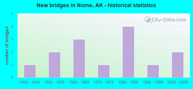
- New bridges - historical statistics
- 11940-1949
- 21950-1959
- 31960-1969
- 11970-1979
- 41980-1989
- 11990-1999
- 22000-2009
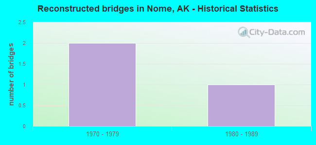
- Reconstructed bridges - Historical Statistics
- 21970-1979
- 11980-1989
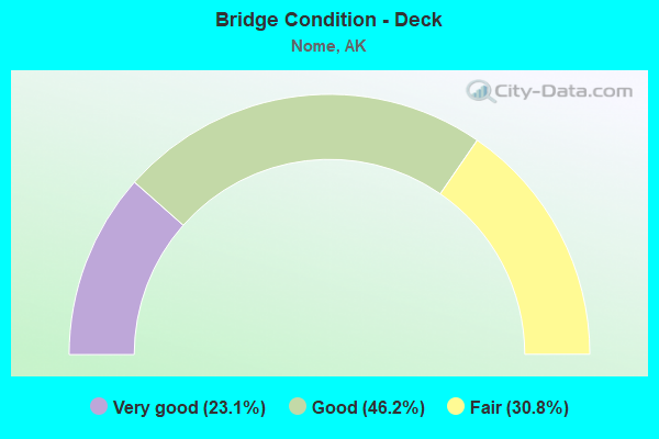
- Bridge Condition - Deck
- 23.1%Very good
- 46.2%Good
- 30.8%Fair
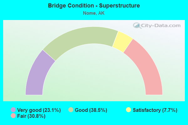
- Bridge Condition - Superstructure
- 23.1%Very good
- 38.5%Good
- 7.7%Satisfactory
- 30.8%Fair
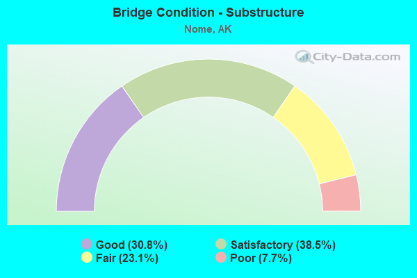
- Bridge Condition - Substructure
- 30.8%Good
- 38.5%Satisfactory
- 23.1%Fair
- 7.7%Poor
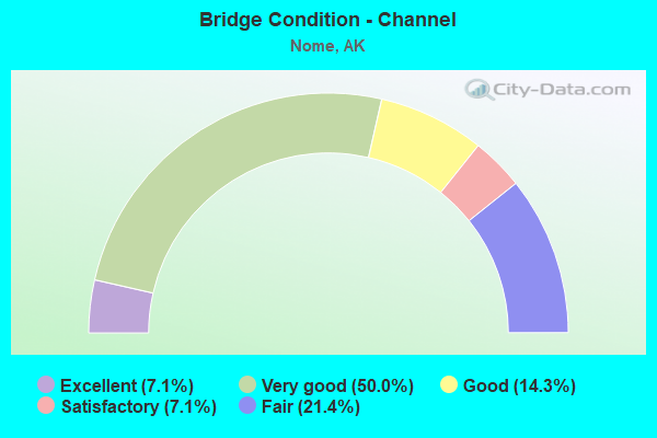
- Bridge Condition - Channel
- 7.1%Excellent
- 50.0%Very good
- 14.3%Good
- 7.1%Satisfactory
- 21.4%Fair
Find on map >> Show street view
Structure Number: 266, Location: MILE POINT 19.4 (Lat: 64.677706, Lng: -165.746242), Route carried "on" structure: State highway 131, Year Built: 1962, Year Reconstructed: 1979, Status: Open, Structure Length: 3.57m (11.71ft), Average Daily Traffic: 20 (year 2020), Truck Traffic: 6%, Average Future Daily Traffic: 30 (year 2039), Design Load: HS 20, Features Intersected: CRIPPLE RIVER, Facility Carried by Structure: IRR:NOME-TELLER RD
Minimum Vertical Clearance: 30+ m (98+ ft), Kilometerpoint: 31.221, Lanes on structure: 2, Owner: State Highway Agency, Approaching Roadway Width: 8.8m (28.9ft), Material/Design: Wood or Timber, Design/Construction: Stringer/Multi-beam, Number Of Spans In Main Unit: 4, Length of Maximum Span: 8.8m (28.9ft), Curb-To-Curb Width: 8.5m (27.9ft), Out-to-Out Width: 8.9m (29.2ft)
Condition: Deck: Good, Superstructure: Good, Substructure: Fair, Channel: Very good, Operating Rating: 63.4 metric tons, Method Used To Determine Operating Rating: Load Factor (LF), Inventory Rating: 37.7 metric tons, Method Used To Determine Inventory Rating: Load Factor (LF), Structural Evaluation: Somewhat better than minimum adequacy, Deck Geometry: Better than present minimum criteria, Waterway Adequacy: Better than present minimum criteria, Approach Roadway Alignment: Equal to present desirable criteria, Designated Inspection Frequency: Every 24 months, Inspection Date: August 2020, Deck Structure Type: Wood or Timber, Wearing Surface/Protective System: Wearing Surface: Wood or Timber
Find on map >> Show street view
Structure Number: 268, Location: MILE POINT 66.0 (Lat: 64.818211, Lng: -163.723206), Route carried "on" structure: State highway 130, Year Built: 1982, Status: Open, Structure Length: 3.66m (12.01ft), Average Daily Traffic: 160 (year 2020), Truck Traffic: 8%, Average Future Daily Traffic: 490 (year 2039), Design Load: HS 20, Features Intersected: FOX RIVER, Facility Carried by Structure: IRR:NOME-COUNCIL
Minimum Vertical Clearance: 30+ m (98+ ft), Kilometerpoint: 106.194, Lanes on structure: 2, Owner: State Highway Agency, Approaching Roadway Width: 7.3m (24.0ft), Material/Design: Wood or Timber, Design/Construction: Stringer/Multi-beam, Number Of Spans In Main Unit: 2, Length of Maximum Span: 18.0m (59.1ft), Curb-To-Curb Width: 7.3m (24.0ft), Out-to-Out Width: 7.6m (24.9ft)
Condition: Deck: Very good, Superstructure: Very good, Substructure: Good, Channel: Very good, Operating Rating: 65.9 metric tons, Method Used To Determine Operating Rating: Load Factor (LF), Inventory Rating: 30.1 metric tons, Method Used To Determine Inventory Rating: Load Factor (LF), Structural Evaluation: Better than present minimum criteria, Deck Geometry: Somewhat better than minimum adequacy, Waterway Adequacy: Equal to present desirable criteria, Approach Roadway Alignment: Equal to present desirable criteria, Designated Inspection Frequency: Every 24 months, Critical Feature Inspection Frequency: Every 24 months, Inspection Date: August 2020, Critical Feature Inspection Date: August 2020, Deck Structure Type: Wood or Timber, Wearing Surface/Protective System: Wearing Surface: Wood or Timber
Find on map >> Show street view
Structure Number: 269, Location: MILE POINT 69.5 (Lat: 64.864700, Lng: -163.692883), Route carried "on" structure: State highway 130, Year Built: 1982, Status: Open, Structure Length: 1.85m (6.07ft), Average Daily Traffic: 160 (year 2020), Truck Traffic: 8%, Average Future Daily Traffic: 490 (year 2039), Design Load: HS 20, Features Intersected: BEAR RIVER, Facility Carried by Structure: IRR:NOME-COUNCIL
Minimum Vertical Clearance: 30+ m (98+ ft), Kilometerpoint: 111.826, Lanes on structure: 2, Owner: State Highway Agency, Approaching Roadway Width: 9.1m (29.9ft), Material/Design: Wood or Timber, Design/Construction: Stringer/Multi-beam, Number Of Spans In Main Unit: 1, Length of Maximum Span: 17.7m (58.1ft), Curb-To-Curb Width: 7.3m (24.0ft), Out-to-Out Width: 7.6m (24.9ft)
Condition: Deck: Very good, Superstructure: Good, Substructure: Good, Channel: Very good, Operating Rating: 67.9 metric tons, Method Used To Determine Operating Rating: Load Factor (LF), Inventory Rating: 31.4 metric tons, Method Used To Determine Inventory Rating: Load Factor (LF), Structural Evaluation: Better than present minimum criteria, Deck Geometry: Somewhat better than minimum adequacy, Waterway Adequacy: Better than present minimum criteria, Approach Roadway Alignment: Equal to present desirable criteria, Designated Inspection Frequency: Every 24 months, Critical Feature Inspection Frequency: Every 24 months, Inspection Date: August 2020, Critical Feature Inspection Date: August 2020, Deck Structure Type: Wood or Timber, Wearing Surface/Protective System: Wearing Surface: Wood or Timber
Find on map >> Show street view
Structure Number: 301, Location: MILE POINT 6.6 (Lat: 55.549100, Lng: -133.097100), Route carried "on" structure: State highway 924, Year Built: 1990, Status: Open, Structure Length: 9.78m (32.09ft), Average Daily Traffic: 1,990 (year 2020), Truck Traffic: 10%, Average Future Daily Traffic: 2,250 (year 2039), Design Load: HS 25 or greater, Features Intersected: KLAWOCK RIVER, Facility Carried by Structure: IRR:CRAIG/KLWK HWY
Minimum Vertical Clearance: 30+ m (98+ ft), Kilometerpoint: 10.552, Lanes on structure: 2, Owner: State Highway Agency, Approaching Roadway Width: 12.5m (41.0ft), Skew: 2 degrees, Material/Design: Prestressed concrete, Design/Construction: Tee Beam, Number Of Spans In Main Unit: 4, Length of Maximum Span: 24.4m (80.1ft), Curb or Sidewalk Widths: Left: 1.8m (5.9ft), Right: 0.0m, Curb-To-Curb Width: 12.3m (40.4ft), Out-to-Out Width: 14.2m (46.6ft)
Condition: Deck: Very good, Superstructure: Very good, Substructure: Satisfactory, Channel: Very good, Operating Rating: 87.7 metric tons, Method Used To Determine Operating Rating: Load Factor (LF), Inventory Rating: 40.4 metric tons, Method Used To Determine Inventory Rating: Load Factor (LF), Structural Evaluation: Equal to present minimum criteria, Deck Geometry: Better than present minimum criteria, Waterway Adequacy: Equal to present desirable criteria, Approach Roadway Alignment: Equal to present desirable criteria, Designated Inspection Frequency: Every 24 months, Underwater Inspection Frequency: Every 60 months, Inspection Date: July 2021, Underwater Inspection Date: August 2021, Deck Structure Type: Other, Wearing Surface/Protective System: Wearing Surface: Bituminous
Find on map >> Show street view
Structure Number: 319, Location: MILE POINT 36.1 (Lat: 64.903331, Lng: -165.102161), Route carried "on" structure: State highway 64, Year Built: 1982, Status: Posted for load, Structure Length: 3.05m (10.01ft), Average Daily Traffic: 249 (year 2018), Truck Traffic: 1%, Average Future Daily Traffic: 300 (year 2035), Design Load: HS 20+Mod, Features Intersected: GRAND CENTRAL RIVER, Facility Carried by Structure: IRR:NOME-TAYLOR RD
Minimum Vertical Clearance: 3.55m (11.65ft), Kilometerpoint: 58.097, Lanes on structure: 2, Owner: State Highway Agency, Approaching Roadway Width: 9.1m (29.9ft), Skew: 3 degrees, Material/Design: Prestressed concrete, Design/Construction: Tee Beam, Number Of Spans In Main Unit: 1, Length of Maximum Span: 29.6m (97.1ft), Curb-To-Curb Width: 8.5m (27.9ft), Out-to-Out Width: 8.8m (28.9ft)
Condition: Deck: Good, Superstructure: Good, Substructure: Satisfactory, Channel: Good, Operating Rating: 63.2 metric tons, Method Used To Determine Operating Rating: Load Factor (LF), Inventory Rating: 20.9 metric tons, Method Used To Determine Inventory Rating: Load Factor (LF), Structural Evaluation: Equal to present minimum criteria, Deck Geometry: Equal to present minimum criteria, Waterway Adequacy: Equal to present desirable criteria, Approach Roadway Alignment: Equal to present desirable criteria, Designated Inspection Frequency: Every 24 months, Inspection Date: August 2020, Deck Structure Type: Other, Wearing Surface/Protective System: Wearing Surface: Monolithic Concrete, Deck Protection: Epoxy Coated Reinforcing
Find on map >> Show street view
Structure Number: 323, Location: MILE POINT 12.4 (Lat: 64.585661, Lng: -165.666811), Route carried "on" structure: State highway 131, Year Built: 1959, Year Reconstructed: 1980, Status: Open, Structure Length: 1.55m (5.09ft), Average Daily Traffic: 20 (year 2020), Truck Traffic: 8%, Average Future Daily Traffic: 30 (year 2039), Design Load: HS 20, Features Intersected: PENNY RIVER, Facility Carried by Structure: IRR:NOME-TELLER RD
Minimum Vertical Clearance: 30+ m (98+ ft), Kilometerpoint: 19.920, Lanes on structure: 2, Owner: State Highway Agency, Approaching Roadway Width: 9.1m (29.9ft), Material/Design: Steel, Design/Construction: Stringer/Multi-beam, Number Of Spans In Main Unit: 1, Length of Maximum Span: 14.9m (48.9ft), Curb-To-Curb Width: 8.5m (27.9ft), Out-to-Out Width: 8.9m (29.2ft)
Condition: Deck: Good, Superstructure: Good, Substructure: Satisfactory, Channel: Fair, Operating Rating: 93.3 metric tons, Method Used To Determine Operating Rating: Load Factor (LF), Inventory Rating: 32.5 metric tons, Method Used To Determine Inventory Rating: Load Factor (LF), Structural Evaluation: Equal to present minimum criteria, Deck Geometry: Better than present minimum criteria, Waterway Adequacy: Somewhat better than minimum adequacy, Approach Roadway Alignment: Equal to present desirable criteria, Designated Inspection Frequency: Every 24 months, Inspection Date: August 2020, Deck Structure Type: Wood or Timber, Wearing Surface/Protective System: Wearing Surface: Wood or Timber
Find on map >> Show street view
Structure Number: 324, Location: MILE POINT 7.1 (Lat: 64.564314, Lng: -165.511414), Route carried "on" structure: State highway 131, Year Built: 1959, Year Reconstructed: 1979, Status: Open, Structure Length: 3.99m (13.09ft), Average Daily Traffic: 20 (year 2020), Truck Traffic: 8%, Average Future Daily Traffic: 30 (year 2039), Design Load: HS 20, Features Intersected: SNAKE RIVER, Facility Carried by Structure: IRR:NOME-TELLER RD
Minimum Vertical Clearance: 30+ m (98+ ft), Kilometerpoint: 11.394, Lanes on structure: 2, Owner: State Highway Agency, Approaching Roadway Width: 7.3m (24.0ft), Material/Design: Steel, Design/Construction: Stringer/Multi-beam, Number Of Spans In Main Unit: 2, Length of Maximum Span: 23.7m (77.8ft), Curb-To-Curb Width: 8.5m (27.9ft), Out-to-Out Width: 8.9m (29.2ft)
Condition: Deck: Fair, Superstructure: Satisfactory, Substructure: Poor, Channel: Fair, Operating Rating: 79.2 metric tons, Method Used To Determine Operating Rating: Load Factor (LF), Inventory Rating: 28.1 metric tons, Method Used To Determine Inventory Rating: Load Factor (LF), Structural Evaluation: Meets minimum limits, Deck Geometry: Better than present minimum criteria, Waterway Adequacy: Somewhat better than minimum adequacy, Approach Roadway Alignment: Equal to present desirable criteria, Designated Inspection Frequency: Every 24 months, Inspection Date: August 2020, Deck Structure Type: Wood or Timber, Wearing Surface/Protective System: Wearing Surface: Wood or Timber
Find on map >> Show street view
Structure Number: 398, Location: MILE POINT 67.9 (Lat: 65.216275, Lng: -164.827903), Route carried "on" structure: State highway 64, Year Built: 1961, Status: Posted for load, Structure Length: 9.33m (30.61ft), Average Daily Traffic: 50 (year 2018), Truck Traffic: 1%, Average Future Daily Traffic: 90 (year 2035), Design Load: H 15, Features Intersected: KUZITRIN RIVER, Facility Carried by Structure: IRR:NOME-TAYLOR RD
Minimum Vertical Clearance: 3.55m (11.65ft), Kilometerpoint: 109.274, Lanes on structure: 1, Owner: State Highway Agency, Approaching Roadway Width: 5.2m (17.1ft), Material/Design: Steel, Design/Construction: Truss - Thru, Number Of Spans In Main Unit: 1, Length of Maximum Span: 91.4m (299.9ft), Curb-To-Curb Width: 5.2m (17.1ft), Out-to-Out Width: 5.5m (18.0ft)
Condition: Deck: Good, Superstructure: Fair, Substructure: Fair, Channel: Very good, Operating Rating: 26.5 metric tons, Method Used To Determine Operating Rating: Load Factor (LF), Inventory Rating: 14.2 metric tons, Method Used To Determine Inventory Rating: Load Factor (LF), Structural Evaluation: Meets minimum limits, Deck Geometry: High priority of corrective action, Waterway Adequacy: Equal to present desirable criteria, Approach Roadway Alignment: Equal to present desirable criteria, Bridge Posting: Required (Relationship of Operating Rating to Maximum Legal Load: 20.0 - 29.9% below), Designated Inspection Frequency: Every 24 months, Critical Feature Inspection Frequency: Every 24 months, Inspection Date: August 2020, Critical Feature Inspection Date: August 2021, Deck Structure Type: Wood or Timber, Wearing Surface/Protective System: Wearing Surface: Wood or Timber
Find on map >> Show street view
Structure Number: 893, Location: MILE POINT 85.4 (Lat: 65.433817, Lng: -164.668178), Route carried "on" structure: State highway NSP00, Year Built: 1941, Status: Posted for load, Structure Length: 5.58m (18.31ft), Average Daily Traffic: 50 (year 2018), Truck Traffic: 1%, Average Future Daily Traffic: 60 (year 2035), Design Load: HS 15, Features Intersected: KOUGAROK RIVER, Facility Carried by Structure: IRR:NOME-TAYLOR RD
Minimum Vertical Clearance: 3.55m (11.65ft), Kilometerpoint: 137.438, Lanes on structure: 1, Owner: State Highway Agency, Approaching Roadway Width: 8.5m (27.9ft), Material/Design: Steel, Design/Construction: Truss - Thru, Number Of Spans In Main Unit: 1, Length of Maximum Span: 55.5m (182.1ft), Curb-To-Curb Width: 3.4m (11.2ft), Out-to-Out Width: 4.0m (13.1ft)
Condition: Deck: Fair, Superstructure: Fair, Substructure: Fair, Channel: Fair, Operating Rating: 24.7 metric tons, Method Used To Determine Operating Rating: Load Factor (LF), Inventory Rating: 11.4 metric tons, Method Used To Determine Inventory Rating: Load Factor (LF), Structural Evaluation: Meets minimum limits, Deck Geometry: High priority of corrective action, Waterway Adequacy: Equal to present minimum criteria, Approach Roadway Alignment: Somewhat better than minimum adequacy, Bridge Posting: Required (Relationship of Operating Rating to Maximum Legal Load: 30.0 - 39.9% below), Designated Inspection Frequency: Every 24 months, Critical Feature Inspection Frequency: Every 24 months, Inspection Date: August 2020, Critical Feature Inspection Date: August 2021, Deck Structure Type: Wood or Timber, Wearing Surface/Protective System: Wearing Surface: Wood or Timber
Find on map >> Show street view
Structure Number: 1127, Location: MILE POINT 20.8 (Lat: 64.472081, Lng: -164.746864), Route carried "on" structure: State highway 130, Year Built: 1978, Status: Open, Structure Length: 24.61m (80.74ft), Average Daily Traffic: 160 (year 2020), Truck Traffic: 8%, Average Future Daily Traffic: 490 (year 2039), Design Load: HS 20, Features Intersected: SAFETY SOUND ESTUARY, Facility Carried by Structure: IRR:NOME-COUNCIL
Minimum Vertical Clearance: 30+ m (98+ ft), Kilometerpoint: 33.500, Lanes on structure: 2, Owner: State Highway Agency, Approaching Roadway Width: 7.3m (24.0ft), Material/Design: Prestressed concrete, Design/Construction: Tee Beam, Number Of Spans In Main Unit: 7, Length of Maximum Span: 35.1m (115.2ft), Curb-To-Curb Width: 7.3m (24.0ft), Out-to-Out Width: 7.6m (24.9ft)
Condition: Deck: Fair, Superstructure: Fair, Substructure: Good, Channel: Very good, Operating Rating: 78.7 metric tons, Method Used To Determine Operating Rating: Load Factor (LF), Inventory Rating: 39.5 metric tons, Method Used To Determine Inventory Rating: Load Factor (LF), Structural Evaluation: Somewhat better than minimum adequacy, Deck Geometry: Somewhat better than minimum adequacy, Waterway Adequacy: Equal to present desirable criteria, Approach Roadway Alignment: Equal to present desirable criteria, Designated Inspection Frequency: Every 24 months, Underwater Inspection Frequency: Every 60 months, Inspection Date: August 2020, Underwater Inspection Date: August 2020, Deck Structure Type: Other, Wearing Surface/Protective System: Wearing Surface: Monolithic Concrete
Find on map >> Show street view
Structure Number: 1564, Location: MILE POINT 43.3 (Lat: 64.929714, Lng: -164.873003), Route carried "on" structure: State highway 64, Year Built: 1983, Status: Posted for load, Structure Length: 3.05m (10.01ft), Average Daily Traffic: 249 (year 2018), Truck Traffic: 1%, Average Future Daily Traffic: 300 (year 2035), Design Load: HS 20, Features Intersected: CRATER CREEK, Facility Carried by Structure: IRR:NOME-TAYLOR RD
Minimum Vertical Clearance: 3.55m (11.65ft), Kilometerpoint: 69.623, Lanes on structure: 2, Owner: State Highway Agency, Approaching Roadway Width: 9.1m (29.9ft), Skew: 3 degrees, Material/Design: Prestressed concrete, Design/Construction: Tee Beam, Number Of Spans In Main Unit: 1, Length of Maximum Span: 29.6m (97.1ft), Curb-To-Curb Width: 8.5m (27.9ft), Out-to-Out Width: 8.8m (28.9ft)
Condition: Deck: Good, Superstructure: Good, Substructure: Satisfactory, Channel: Satisfactory, Operating Rating: 63.2 metric tons, Method Used To Determine Operating Rating: Load Factor (LF), Inventory Rating: 20.9 metric tons, Method Used To Determine Inventory Rating: Load Factor (LF), Structural Evaluation: Equal to present minimum criteria, Deck Geometry: Equal to present minimum criteria, Waterway Adequacy: Equal to present minimum criteria, Approach Roadway Alignment: Equal to present desirable criteria, Designated Inspection Frequency: Every 24 months, Inspection Date: August 2020, Deck Structure Type: Concrete Precast Panels, Wearing Surface/Protective System: Wearing Surface: Monolithic Concrete, Deck Protection: Epoxy Coated Reinforcing
Find on map >> Show street view
Structure Number: 214, Location: MILE POINT 3.2 (Lat: 64.594819, Lng: -165.436306), Route carried "on" structure: State highway , Year Built: 2005, Status: Open, Structure Length: 3.12m (10.24ft), Average Daily Traffic: 60 (year 2020), Truck Traffic: 8%, Average Future Daily Traffic: 70 (year 2039), Design Load: HL 93, Features Intersected: GLACIER CREEK, Facility Carried by Structure: GLACIER CR ROAD
Minimum Vertical Clearance: 30+ m (98+ ft), Kilometerpoint: 5.150, Lanes on structure: 2, Owner: State Highway Agency, Approaching Roadway Width: 7.6m (24.9ft), Skew: 2 degrees, Material/Design: Prestressed concrete, Design/Construction: Tee Beam, Number Of Spans In Main Unit: 1, Length of Maximum Span: 30.5m (100.1ft), Curb-To-Curb Width: 7.3m (24.0ft), Out-to-Out Width: 8.2m (26.9ft)
Condition: Deck: Good, Superstructure: Very good, Substructure: Good, Channel: Excellent, Inventory Rating: 52.3 metric tons, Method Used To Determine Inventory Rating: Load Factor (LF), Structural Evaluation: Better than present minimum criteria, Deck Geometry: Equal to present minimum criteria, Waterway Adequacy: Superior to present desirable criteria, Approach Roadway Alignment: Equal to present desirable criteria, Designated Inspection Frequency: Every 24 months, Inspection Date: August 2020, Deck Structure Type: Other, Wearing Surface/Protective System: Wearing Surface: Monolithic Concrete, Deck Protection: Epoxy Coated Reinforcing
Find on map >> Show street view
Structure Number: 4075, Location: MILE POINT 4.8 (Lat: 64.551103, Lng: -165.442347), Route carried "on" structure: State highway , Year Built: 1967, Status: Open, Structure Length: 0.72m (2.36ft), Average Daily Traffic: 170 (year 2020), Truck Traffic: 8%, Average Future Daily Traffic: 210 (year 2039), Design Load: H 20, Features Intersected: ANVIL CREEK, Facility Carried by Structure: IRR:NOME-TELLER RD
Minimum Vertical Clearance: 30+ m (98+ ft), Kilometerpoint: 7.678, Lanes on structure: 2, Owner: State Highway Agency, Approaching Roadway Width: 8.1m (26.6ft), Material/Design: Steel, Design/Construction: Culvert, Number Of Spans In Main Unit: 2, Length of Maximum Span: 3.0m (9.8ft)
Condition: Channel: Good, Culverts: Satisfactory, Operating Rating: 42.5 metric tons, Method Used To Determine Operating Rating: Load Factor (LF), Inventory Rating: 35.3 metric tons, Method Used To Determine Inventory Rating: Load Factor (LF), Structural Evaluation: Equal to present minimum criteria, Waterway Adequacy: Better than present minimum criteria, Approach Roadway Alignment: Equal to present desirable criteria, Designated Inspection Frequency: Every 24 months, Inspection Date: August 2020
Find on map >> Show street view
Structure Number: CEPPOAAK0001002, Location: NOME, ALASKA (Lat: 64.498736, Lng: -165.436689), Route carried "on" structure: ServiceOther road , Year Built: 2005, Status: Open, Structure Length: 3.90m (12.80ft), Average Daily Traffic: 75 (year 2017), Truck Traffic: 35%, Average Future Daily Traffic: 110 (year 2037), Design Load: HS 25 or greater, Features Intersected: NOME HARBOR, Facility Carried by Structure: ROAD
Minimum Vertical Clearance: 30+ m (98+ ft), Kilometerpoint: 0.000, Lanes on structure: 2, Owner: Corps of Engineers (Civil), Approaching Roadway Width: 8.9m (29.2ft), Navigation Control: Yes ( Vertical Clearance: 2.9m (9.5ft), Horizontal Clearance: 29.9m (98.1ft)), Material/Design: Steel, Design/Construction: Stringer/Multi-beam, Number Of Spans In Main Unit: 1, Length of Maximum Span: 35.9m (117.8ft), Curb-To-Curb Width: 8.9m (29.2ft), Out-to-Out Width: 10.3m (33.8ft)
Condition: Deck: Fair, Superstructure: Fair, Substructure: Satisfactory, Channel: Very good, Operating Rating: 58.6 metric tons, Method Used To Determine Operating Rating: Load and Resistance Factor Rating (LRFR) rating reported by rating factor(RF) method using HL-93 loadings, Inventory Rating: 36.3 metric tons, Method Used To Determine Inventory Rating: Load and Resistance Factor Rating (LRFR) rating reported by rating factor(RF) method using HL-93 loadings, Structural Evaluation: Somewhat better than minimum adequacy, Waterway Adequacy: Better than present minimum criteria, Approach Roadway Alignment: Better than present minimum criteria, Length Of Structure Improvement: 7.42m (24.34ft), Designated Inspection Frequency: Every 24 months, Underwater Inspection Frequency: Every 60 months, Inspection Date: June 2020, Underwater Inspection Date: June 2020, Bridge Improvement Cost: $278,000, Roadway Improvement Cost: $28,000, Total Project Cost: $417,000 ( Estimate for 2020), Deck Structure Type: Concrete Precast Panels