Bridge Statistics for North Aurora, Illinois (IL)
Condition, Traffic, Stress, Structural Evaluation, Project Costs
- National Bridge Inventory (NBI) Statistics
- 17Number of bridges
- 459ft / 140mTotal length
- $9,154,000Total costs
- 507,725Total average daily traffic
- 93,033Total average daily truck traffic
- National Bridge Inventory (NBI) Registered Bridges for North Aurora
- No street view available for this location
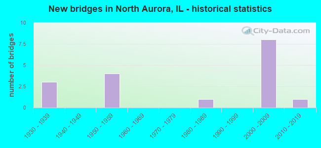
- New bridges - historical statistics
- 31930-1939
- 41950-1959
- 11980-1989
- 82000-2009
- 12010-2019

- Reconstructed bridges - Historical Statistics
- 11960-1969
- 01970-1979
- 01980-1989
- 11990-1999
- 12000-2009
- 12010-2019

- Bridge Condition - Deck
- 63.6%Good
- 27.3%Satisfactory
- 9.1%Fair
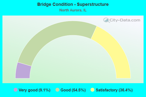
- Bridge Condition - Superstructure
- 9.1%Very good
- 54.5%Good
- 36.4%Satisfactory
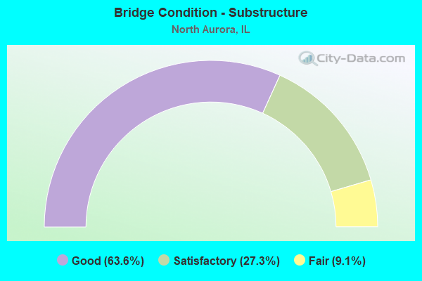
- Bridge Condition - Substructure
- 63.6%Good
- 27.3%Satisfactory
- 9.1%Fair
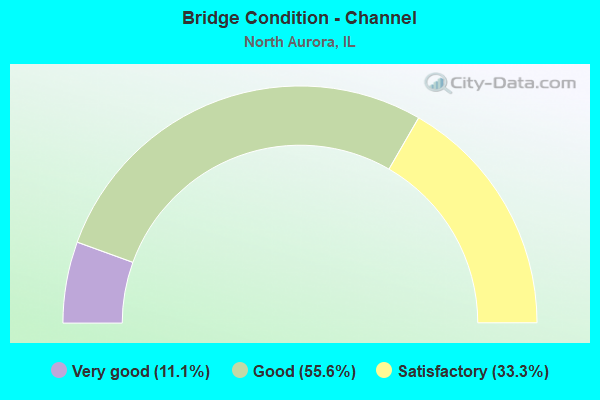
- Bridge Condition - Channel
- 11.1%Very good
- 55.6%Good
- 33.3%Satisfactory
Find on map >> Show street view
Structure Number: 45002, Location: 1.1 M N OF IL 56 (Lat: 41.821975, Lng: -88.325403), Route carried "on" structure: State highway 31, Year Built: 1935, Year Reconstructed: 2008, Status: Open, Structure Length: 1.37m (4.49ft), Average Daily Traffic: 20,700 (year 2021), Truck Traffic: 4%, Average Future Daily Traffic: 17,864 (year 2032), Design Load: HS 20, Features Intersected: MILL CREEK
Minimum Vertical Clearance: 30+ m (98+ ft), Kilometerpoint: 16.705, Lanes on structure: 4, Base Highway Network: Yes, Owner: State Highway Agency, Approaching Roadway Width: 12.8m (42.0ft), Material/Design: Prestressed concrete, Design/Construction: Box Beam or Girders - Multiple, Number Of Spans In Main Unit: 1, Length of Maximum Span: 12.4m (40.7ft), Curb or Sidewalk Widths: Left: 1.5m (4.9ft), Right: 1.5m (4.9ft), Curb-To-Curb Width: 12.8m (42.0ft), Out-to-Out Width: 16.5m (54.1ft)
Condition: Deck: Good, Superstructure: Satisfactory, Substructure: Fair, Channel: Satisfactory, Operating Rating: 67.1 metric tons, Method Used To Determine Operating Rating: Load Factor (LF) rating reported by rating factor (RF) method using MS18 loading, Inventory Rating: 40.2 metric tons, Method Used To Determine Inventory Rating: Load Factor (LF) rating reported by rating factor (RF) method using MS18 loading, Structural Evaluation: Somewhat better than minimum adequacy, Deck Geometry: High priority of replacement, Waterway Adequacy: Equal to present minimum criteria, Approach Roadway Alignment: Equal to present desirable criteria, Length Of Structure Improvement: 1.98m (6.50ft), Designated Inspection Frequency: Every 24 months, Inspection Date: January 2022, Bridge Improvement Cost: $307,000, Roadway Improvement Cost: $31,000, Total Project Cost: $461,000, Deck Structure Type: Concrete Cast-file-Place, Wearing Surface/Protective System: Wearing Surface: Integral Concrete, Deck Protection: Epoxy Coated Reinforcing
Find on map >> Show street view
Structure Number: 450054, Location: 0.1 MI E OF IL 31 (Lat: 41.806439, Lng: -88.324442), Route carried "on" structure: State highway 56, Year Built: 1931, Year Reconstructed: 1972, Status: Open, Structure Length: 11.17m (36.65ft), Average Daily Traffic: 12,200 (year 2021), Truck Traffic: 4%, Average Future Daily Traffic: 14,546 (year 2032), Design Load: HS 20, Features Intersected: FOX RIVER
Minimum Vertical Clearance: 30+ m (98+ ft), Kilometerpoint: 13.116, Lanes on structure: 2, Base Highway Network: Yes, Owner: State Highway Agency, Approaching Roadway Width: 12.2m (40.0ft), Material/Design: Concrete, Number Of Spans In Main Unit: 5, Length of Maximum Span: 22.6m (74.1ft), Curb or Sidewalk Widths: Left: 1.8m (5.9ft), Right: 1.8m (5.9ft), Curb-To-Curb Width: 9.8m (32.2ft), Out-to-Out Width: 14.5m (47.6ft)
Condition: Deck: Fair, Superstructure: Satisfactory, Substructure: Satisfactory, Channel: Good, Operating Rating: 62.9 metric tons, Method Used To Determine Operating Rating: Load Factor (LF) rating reported by rating factor (RF) method using MS18 loading, Inventory Rating: 37.9 metric tons, Method Used To Determine Inventory Rating: Load Factor (LF) rating reported by rating factor (RF) method using MS18 loading, Structural Evaluation: Equal to present minimum criteria, Deck Geometry: Meets minimum limits, Waterway Adequacy: Superior to present desirable criteria, Approach Roadway Alignment: Equal to present minimum criteria, Designated Inspection Frequency: Every 24 months, Inspection Date: August 2021, Deck Structure Type: Concrete Cast-file-Place, Wearing Surface/Protective System: Wearing Surface: Latex Concrete
Find on map >> Show street view
Structure Number: 450055, Location: 0.1 M W OF IL 25 (Lat: 41.806728, Lng: -88.322650), Route carried "on" structure: State highway 56, Year Built: 1932, Year Reconstructed: 1998, Status: Open, Structure Length: 1.41m (4.63ft), Average Daily Traffic: 12,200 (year 2021), Truck Traffic: 4%, Average Future Daily Traffic: 14,546 (year 2032), Design Load: HS 20, Features Intersected: FOX RIVER TAILRACE
Minimum Vertical Clearance: 30+ m (98+ ft), Kilometerpoint: 13.261, Lanes on structure: 2, Base Highway Network: Yes, Owner: State Highway Agency, Approaching Roadway Width: 12.2m (40.0ft), Skew: 1 degrees, Material/Design: Steel, Design/Construction: Stringer/Multi-beam, Number Of Spans In Main Unit: 1, Length of Maximum Span: 13.4m (44.0ft), Curb or Sidewalk Widths: Left: 1.7m (5.6ft), Right: 1.7m (5.6ft), Curb-To-Curb Width: 11.0m (36.1ft), Out-to-Out Width: 15.0m (49.2ft)
Condition: Deck: Good, Superstructure: Good, Substructure: Good, Channel: Satisfactory, Operating Rating: 63.8 metric tons, Method Used To Determine Operating Rating: Load Factor (LF) rating reported by rating factor (RF) method using MS18 loading, Inventory Rating: 38.2 metric tons, Method Used To Determine Inventory Rating: Load Factor (LF) rating reported by rating factor (RF) method using MS18 loading, Structural Evaluation: Better than present minimum criteria, Deck Geometry: Meets minimum limits, Waterway Adequacy: Equal to present desirable criteria, Approach Roadway Alignment: Equal to present minimum criteria, Designated Inspection Frequency: Every 48 months, Inspection Date: January 2018, Deck Structure Type: Concrete Cast-file-Place, Wearing Surface/Protective System: Deck Protection: Epoxy Coated Reinforcing
Find on map >> Show street view
Structure Number: 450329, Location: I-88; 0.4 M W IL 25 (Lat: 41.796053, Lng: -88.323889), Route carried "on" structure: State highway 31, Year Built: 2008, Status: Open, Structure Length: 7.22m (23.69ft), Average Daily Traffic: 16,800 (year 2021), Truck Traffic: 4%, Average Future Daily Traffic: 21,054 (year 2032), Design Load: HS 20, Features Intersected: I- 88
Minimum Vertical Clearance: 30+ m (98+ ft), Kilometerpoint: 13.727, Lanes on structure: 4, Lanes under structure: 4, Base Highway Network: Yes, Owner: State Highway Agency, Approaching Roadway Width: 21.5m (70.5ft), Skew: 20 degrees, Material/Design: Steel continuous, Design/Construction: Stringer/Multi-beam, Number Of Spans In Main Unit: 2, Length of Maximum Span: 36.2m (118.8ft), Curb or Sidewalk Widths: Left: 1.5m (4.9ft), Right: 1.5m (4.9ft), Curb-To-Curb Width: 21.5m (70.5ft), Out-to-Out Width: 25.2m (82.7ft)
Condition: Deck: Good, Superstructure: Good, Substructure: Good, Operating Rating: 65.8 metric tons, Method Used To Determine Operating Rating: Load Factor (LF) rating reported by rating factor (RF) method using MS18 loading, Inventory Rating: 39.2 metric tons, Method Used To Determine Inventory Rating: Load Factor (LF) rating reported by rating factor (RF) method using MS18 loading, Structural Evaluation: Better than present minimum criteria, Deck Geometry: Superior to present desirable criteria, Underclear: Somewhat better than minimum adequacy, Approach Roadway Alignment: Equal to present desirable criteria, Designated Inspection Frequency: Every 24 months, Inspection Date: September 2020, Deck Structure Type: Concrete Cast-file-Place, Wearing Surface/Protective System: Deck Protection: Epoxy Coated Reinforcing
Find on map >> Show street view
Structure Number: 45332, Location: .8 MI E OF BLISS RD (Lat: 41.828000, Lng: -88.397669), Route carried "on" structure: County highway , Year Built: 1981, Year Reconstructed: 2016, Status: Open, Structure Length: 1.69m (5.54ft), Average Daily Traffic: 775 (year 2018), Truck Traffic: 3%, Average Future Daily Traffic: 1,021 (year 2032), Design Load: HS 25 or greater, Features Intersected: LAKE RUN CREEK, Facility Carried by Structure: SEAVEY ROAD
Minimum Vertical Clearance: 30+ m (98+ ft), Kilometerpoint: 7.033, Lanes on structure: 2, Owner: Town or Township Highway Agency, Approaching Roadway Width: 6.7m (22.0ft), Skew: 1 degrees, Material/Design: Prestressed concrete, Design/Construction: Box Beam or Girders - Multiple, Number Of Spans In Main Unit: 1, Length of Maximum Span: 15.9m (52.2ft), Curb-To-Curb Width: 8.2m (26.9ft), Out-to-Out Width: 8.2m (26.9ft)
Condition: Deck: Good, Superstructure: Very good, Substructure: Good, Channel: Good, Operating Rating: 49.2 metric tons, Method Used To Determine Operating Rating: Load and Resistance Factor Rating (LRFR) rating reported by rating factor(RF) method using HL-93 loadings, Inventory Rating: 38.2 metric tons, Method Used To Determine Inventory Rating: Load and Resistance Factor Rating (LRFR) rating reported by rating factor(RF) method using HL-93 loadings, Structural Evaluation: Better than present minimum criteria, Deck Geometry: Somewhat better than minimum adequacy, Waterway Adequacy: Equal to present desirable criteria, Approach Roadway Alignment: Equal to present desirable criteria, Designated Inspection Frequency: Every 48 months, Inspection Date: January 2020, Deck Structure Type: Concrete Precast Panels, Wearing Surface/Protective System: Wearing Surface: Integral Concrete, Deck Protection: Epoxy Coated Reinforcing
Find on map >> Show street view
Structure Number: 453324, Location: 0.27 M E of Norris (Lat: 41.811153, Lng: -88.402894), Route carried "on" structure: County highway , Year Built: 2015, Status: Open, Structure Length: 1.98m (6.50ft), Average Daily Traffic: 1,700 (year 2018), Truck Traffic: 3%, Average Future Daily Traffic: 2,550 (year 2032), Design Load: HS 25 or greater, Features Intersected: LAKE RUN CREEK, Facility Carried by Structure: TANNER ROAD
Minimum Vertical Clearance: 30+ m (98+ ft), Kilometerpoint: 0.467, Lanes on structure: 2, Owner: County Highway Agency, Approaching Roadway Width: 12.2m (40.0ft), Skew: 1 degrees, Material/Design: Concrete continuous, Design/Construction: Slab, Number Of Spans In Main Unit: 2, Length of Maximum Span: 11.2m (36.7ft), Curb-To-Curb Width: 12.2m (40.0ft), Out-to-Out Width: 12.2m (40.0ft)
Condition: Deck: Satisfactory, Superstructure: Satisfactory, Substructure: Good, Channel: Very good, Operating Rating: 45.4 metric tons, Method Used To Determine Operating Rating: Load and Resistance Factor Rating (LRFR) rating reported by rating factor(RF) method using HL-93 loadings, Inventory Rating: 23.7 metric tons, Method Used To Determine Inventory Rating: Load and Resistance Factor Rating (LRFR) rating reported by rating factor(RF) method using HL-93 loadings, Structural Evaluation: Equal to present minimum criteria, Deck Geometry: Better than present minimum criteria, Waterway Adequacy: Equal to present desirable criteria, Approach Roadway Alignment: Equal to present desirable criteria, Designated Inspection Frequency: Every 24 months, Inspection Date: April 2021, Deck Structure Type: Concrete Cast-file-Place, Wearing Surface/Protective System: Deck Protection: Epoxy Coated Reinforcing
Find on map >> Show street view
Structure Number: 456018, Location: IL RT 31 TO IL RT 25 (Lat: 41.788903, Lng: -88.318217), Route carried "on" structure: Other road , Year Built: 2006, Status: Open, Structure Length: 21.13m (69.32ft), Average Daily Traffic: 11,700 (year 2018), Truck Traffic: 13%, Average Future Daily Traffic: 13,526 (year 2032), Design Load: HS 20, Features Intersected: FOX RIVER, Facility Carried by Structure: SULLIVAN ROAD
Minimum Vertical Clearance: 30+ m (98+ ft), Kilometerpoint: 4.780, Lanes on structure: 4, Owner: City or Municipal Highway Agency, Approaching Roadway Width: 16.1m (52.8ft), Skew: 32 degrees, Material/Design: Steel continuous, Design/Construction: Stringer/Multi-beam, Number Of Spans In Main Unit: 5, Length of Maximum Span: 50.0m (164.0ft), Curb or Sidewalk Widths: Left: 0.0m, Right: 3.7m (12.1ft), Curb-To-Curb Width: 16.1m (52.8ft), Out-to-Out Width: 21.8m (71.5ft)
Condition: Deck: Satisfactory, Superstructure: Good, Substructure: Good, Channel: Good, Operating Rating: 44.1 metric tons, Method Used To Determine Operating Rating: Assigned rating based on Load Factor Design (LFD) reported by rating factor (RF) using MS18 loading, Inventory Rating: 32.4 metric tons, Method Used To Determine Inventory Rating: Assigned rating based on Load Factor Design (LFD) reported by rating factor (RF) using MS18 loading, Structural Evaluation: Better than present minimum criteria, Deck Geometry: Meets minimum limits, Waterway Adequacy: Superior to present desirable criteria, Approach Roadway Alignment: Equal to present desirable criteria, Designated Inspection Frequency: Every 24 months, Inspection Date: September 2021, Deck Structure Type: Concrete Cast-file-Place, Wearing Surface/Protective System: Deck Protection: Epoxy Coated Reinforcing
Find on map >> Show street view
Structure Number: 456399, Location: 0.29 MI E ORCHARD RD (Lat: 41.800975, Lng: -88.368981), Route carried "on" structure: City street , Year Built: 2006, Status: Open, Structure Length: 0.85m (2.79ft), Average Daily Traffic: 5,150 (year 2018), Truck Traffic: 3%, Average Future Daily Traffic: 6,130 (year 2040), Features Intersected: E RUN BLACKBERRY CRE, Facility Carried by Structure: ORCHARD GATEWAY BL
Minimum Vertical Clearance: 30+ m (98+ ft), Kilometerpoint: 0.595, Lanes on structure: 5, Owner: City or Municipal Highway Agency, Approaching Roadway Width: 19.5m (64.0ft), Skew: 30 degrees, Material/Design: Concrete, Design/Construction: Culvert, Number Of Spans In Main Unit: 4, Length of Maximum Span: 0.0m
Condition: Channel: Satisfactory, Culverts: Satisfactory, Operating Rating: 65.1 metric tons, Method Used To Determine Operating Rating: Load and Resistance Factor Rating (LRFR) rating reported by rating factor(RF) method using HL-93 loadings, Inventory Rating: 50.2 metric tons, Method Used To Determine Inventory Rating: Load and Resistance Factor Rating (LRFR) rating reported by rating factor(RF) method using HL-93 loadings, Structural Evaluation: Equal to present minimum criteria, Waterway Adequacy: Equal to present desirable criteria, Approach Roadway Alignment: Equal to present minimum criteria, Designated Inspection Frequency: Every 24 months, Inspection Date: October 2021
Find on map >> Show street view
Structure Number: 459908, Location: 1 MI N INDIAN TRAIL (Lat: 41.797161, Lng: -88.349819), Route carried "on" structure: Other road , Year Built: 1958, Status: Open, Structure Length: 6.52m (21.39ft), Average Daily Traffic: 17,700 (year 2018), Truck Traffic: 6%, Average Future Daily Traffic: 15,312 (year 2032), Design Load: HS 20, Features Intersected: I-88 (EW TOLLWAY), Facility Carried by Structure: RANDALL ROAD
Minimum Vertical Clearance: 30+ m (98+ ft), Kilometerpoint: 2.285, Lanes on structure: 2, Lanes under structure: 4, Base Highway Network: Yes, Owner: City or Municipal Highway Agency, Approaching Roadway Width: 9.1m (29.9ft), Skew: 1 degrees, Material/Design: Prestressed concrete, Design/Construction: Stringer/Multi-beam, Number Of Spans In Main Unit: 4, Length of Maximum Span: 19.5m (64.0ft), Curb or Sidewalk Widths: Left: 1.5m (4.9ft), Right: 1.5m (4.9ft), Curb-To-Curb Width: 9.1m (29.9ft), Out-to-Out Width: 12.8m (42.0ft)
Condition: Deck: Satisfactory, Superstructure: Good, Substructure: Good, Operating Rating: 67.7 metric tons, Method Used To Determine Operating Rating: Load Factor (LF) rating reported by rating factor (RF) method using MS18 loading, Inventory Rating: 40.5 metric tons, Method Used To Determine Inventory Rating: Load Factor (LF) rating reported by rating factor (RF) method using MS18 loading, Structural Evaluation: Better than present minimum criteria, Deck Geometry: Meets minimum limits, Underclear: Meets minimum limits, Approach Roadway Alignment: Equal to present desirable criteria, Designated Inspection Frequency: Every 24 months, Inspection Date: August 2020, Deck Structure Type: Concrete Cast-file-Place, Wearing Surface/Protective System: Wearing Surface: Bituminous, Membrane: Built-up
Find on map >> Show street view
Structure Number: 459928, Location: W OF ILL 31 (Lat: 41.796206, Lng: -88.317600), Route carried "on" structure: Interstate 88, Year Built: 1958, Status: Open, Structure Length: 40.63m (133.30ft), Average Daily Traffic: 81,200 (year 2020), Truck Traffic: 22%, Average Future Daily Traffic: 101,059 (year 2032), Design Load: HS 20, Features Intersected: FOX R - RR - IL 25
Minimum Vertical Clearance: 30+ m (98+ ft), Kilometerpoint: 188.224, Lanes on structure: 4, Lanes under structure: 4, Base Highway Network: Yes, Toll: On toll road, Owner: State Toll Authority, Approaching Roadway Width: 24.7m (81.0ft), Skew: 31 degrees, Material/Design: Concrete, Number Of Spans In Main Unit: 5, Number Of Approach Spans: 6, Length of Maximum Span: 54.3m (178.1ft), Curb-To-Curb Width: 19.5m (64.0ft), Out-to-Out Width: 21.0m (68.9ft)
Condition: Deck: Good, Superstructure: Good, Substructure: Satisfactory, Channel: Good, Operating Rating: 61.6 metric tons, Method Used To Determine Operating Rating: Load Factor (LF) rating reported by rating factor (RF) method using MS18 loading, Inventory Rating: 36.9 metric tons, Method Used To Determine Inventory Rating: Load Factor (LF) rating reported by rating factor (RF) method using MS18 loading, Structural Evaluation: Equal to present minimum criteria, Deck Geometry: Somewhat better than minimum adequacy, Underclear: Superior to present desirable criteria, Waterway Adequacy: Superior to present desirable criteria, Approach Roadway Alignment: Equal to present desirable criteria, Length Of Structure Improvement: 40.63m (133.30ft), Designated Inspection Frequency: Every 24 months, Underwater Inspection Frequency: Every 60 months, Inspection Date: June 2020, Underwater Inspection Date: April 2018, Bridge Improvement Cost: $5,795,000, Roadway Improvement Cost: $580,000, Total Project Cost: $8,693,000, Deck Structure Type: Concrete Cast-file-Place
Find on map >> Show street view
Structure Number: 459931, Location: 0.2MI W OF IL31 (Lat: 41.795950, Lng: -88.327533), Route carried "on" structure: Other road , Year Built: 2008, Status: Open, Structure Length: 5.53m (18.14ft), Average Daily Traffic: 1,500 (year 2020), Average Future Daily Traffic: 74,263 (year 2032), Design Load: HS 20, Features Intersected: I-88 E-W TOLL, Facility Carried by Structure: IL31 RMP TO I88WB
Minimum Vertical Clearance: 30+ m (98+ ft), Kilometerpoint: 0.547, Lanes on structure: 2, Lanes under structure: 5, Base Highway Network: Yes (Inventory Route: 10088041, Subroute: 10), Toll: On toll road, Owner: State Toll Authority, Approaching Roadway Width: 9.8m (32.2ft), Material/Design: Prestressed concrete, Design/Construction: Stringer/Multi-beam, Number Of Spans In Main Unit: 2, Number Of Approach Spans: 2, Length of Maximum Span: 29.5m (96.8ft), Curb-To-Curb Width: 19.5m (64.0ft), Out-to-Out Width: 21.5m (70.5ft)
Condition: Deck: Good, Superstructure: Satisfactory, Substructure: Good, Operating Rating: 71.9 metric tons, Method Used To Determine Operating Rating: Load Factor (LF) rating reported by rating factor (RF) method using MS18 loading, Inventory Rating: 43.1 metric tons, Method Used To Determine Inventory Rating: Load Factor (LF) rating reported by rating factor (RF) method using MS18 loading, Structural Evaluation: Equal to present minimum criteria, Deck Geometry: Superior to present desirable criteria, Underclear: Somewhat better than minimum adequacy, Approach Roadway Alignment: Equal to present desirable criteria, Designated Inspection Frequency: Every 24 months, Inspection Date: September 2020, Deck Structure Type: Concrete Cast-file-Place
Find on map >> Show street view
Structure Number: 459938, Location: 0.1MI E OF IL 31 (Lat: 41.796206, Lng: -88.317600), Route carried "on" structure: Interstate 88, Year Built: 2008, Status: Open, Structure Length: 40.80m (133.86ft), Average Daily Traffic: 81,200 (year 2020), Truck Traffic: 22%, Average Future Daily Traffic: 91,872 (year 2032), Design Load: HS 20, Features Intersected: FOX R - RR - IL 25
Minimum Vertical Clearance: 30+ m (98+ ft), Kilometerpoint: 188.224, Lanes on structure: 4, Lanes under structure: 4, Base Highway Network: Yes, Toll: On toll road, Owner: State Toll Authority, Approaching Roadway Width: 21.8m (71.5ft), Skew: 1 degrees, Material/Design: Concrete, Number Of Spans In Main Unit: 10, Number Of Approach Spans: 2, Length of Maximum Span: 54.4m (178.5ft), Curb-To-Curb Width: 21.8m (71.5ft), Out-to-Out Width: 22.9m (75.1ft)
Condition: Deck: Good, Superstructure: Good, Substructure: Satisfactory, Channel: Good, Operating Rating: 66.1 metric tons, Method Used To Determine Operating Rating: Load Factor (LF) rating reported by rating factor (RF) method using MS18 loading, Inventory Rating: 39.5 metric tons, Method Used To Determine Inventory Rating: Load Factor (LF) rating reported by rating factor (RF) method using MS18 loading, Structural Evaluation: Equal to present minimum criteria, Deck Geometry: Better than present minimum criteria, Waterway Adequacy: Superior to present desirable criteria, Approach Roadway Alignment: Equal to present desirable criteria, Designated Inspection Frequency: Every 24 months, Underwater Inspection Frequency: Every 60 months, Inspection Date: June 2020, Underwater Inspection Date: April 2018, Deck Structure Type: Concrete Cast-file-Place, Wearing Surface/Protective System: Deck Protection: Epoxy Coated Reinforcing
Find on map >> Show street view
Structure Number: 450329, Location: I-88; 0.4 M W IL 25 (Lat: 41.795864, Lng: -88.323828), Route carried "under" structure: Interstate 88, Year Built: 2008, Structure Length: 0. m, Average Daily Traffic: 81,200 (year 2020), Truck Traffic: 22%, Features Intersected: I- 88, Facility Carried by Structure: IL 31
Minimum Vertical Clearance: 4.95m (16.24ft), Kilometerpoint: 188.079, Lanes on structure: 4, Lanes under structure: 4, Material/Design: Steel continuous, Design/Construction: Stringer/Multi-beam, Length of Maximum Span: 36.2m (118.8ft)
Find on map >> Show street view
Structure Number: 459908, Location: 1 MI N INDIAN TRAIL (Lat: 41.795200, Lng: -88.349769), Route carried "under" structure: Interstate 88, Year Built: 1958, Structure Length: 0. m, Average Daily Traffic: 67,000 (year 2020), Truck Traffic: 22%, Features Intersected: I-88 (EW TOLLWAY), Facility Carried by Structure: RANDALL ROAD
Minimum Vertical Clearance: 4.65m (15.26ft), Kilometerpoint: 185.890, Lanes on structure: 2, Lanes under structure: 4, Material/Design: Prestressed concrete, Design/Construction: Stringer/Multi-beam, Length of Maximum Span: 19.5m (64.0ft)
Find on map >> Show street view
Structure Number: 459928, Location: W OF ILL 31 (Lat: 41.794994, Lng: -88.317092), Route carried "under" structure: State highway 25, Year Built: 1958, Structure Length: 0. m, Average Daily Traffic: 7,750 (year 2021), Truck Traffic: 10%, Features Intersected: FOX R - RR - IL 25, Facility Carried by Structure: I-88 WB
Minimum Vertical Clearance: 5.38m (17.65ft), Kilometerpoint: 13.760, Lanes on structure: 4, Lanes under structure: 4, Toll: On toll road, Material/Design: Concrete, Length of Maximum Span: 54.3m (178.1ft)
Find on map >> Show street view
Structure Number: 459931, Location: 0.2MI W OF IL31 (Lat: 41.795619, Lng: -88.328078), Route carried "under" structure: Interstate 88, Year Built: 2008, Structure Length: 0. m, Average Daily Traffic: 81,200 (year 2020), Truck Traffic: 22%, Features Intersected: I-88 E-W TOLL
Minimum Vertical Clearance: 4.93m (16.17ft), Kilometerpoint: 187.789, Lanes on structure: 2, Lanes under structure: 5, Toll: On toll road, Material/Design: Prestressed concrete, Design/Construction: Stringer/Multi-beam, Length of Maximum Span: 29.5m (96.8ft)
Find on map >> Show street view
Structure Number: 459938, Location: 0.1MI E OF IL 31 (Lat: 41.794994, Lng: -88.317092), Route carried "under" structure: State highway 25, Year Built: 2008, Structure Length: 0. m, Average Daily Traffic: 7,750 (year 2021), Truck Traffic: 10%, Features Intersected: FOX R - RR - IL 25, Facility Carried by Structure: I-88 EB
Minimum Vertical Clearance: 5.03m (16.50ft), Kilometerpoint: 13.760, Lanes on structure: 4, Lanes under structure: 4, Toll: On toll road, Material/Design: Concrete, Length of Maximum Span: 54.4m (178.5ft)