Bridge Statistics for North Hempstead, New York (NY)
Condition, Traffic, Stress, Structural Evaluation, Project Costs
- National Bridge Inventory (NBI) Statistics
- 35Number of bridges
- 203ft / 62.4mTotal length
- $107,717,000Total costs
- 2,134,373Total average daily traffic
- 31,709Total average daily truck traffic
- National Bridge Inventory (NBI) Registered Bridges for North Hempstead
- No street view available for this location
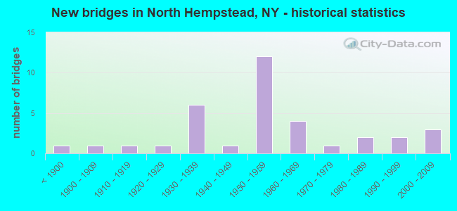
- New bridges - historical statistics
- 1Before 1900
- 11900-1909
- 11910-1919
- 11920-1929
- 61930-1939
- 11940-1949
- 121950-1959
- 41960-1969
- 11970-1979
- 21980-1989
- 21990-1999
- 32000-2009
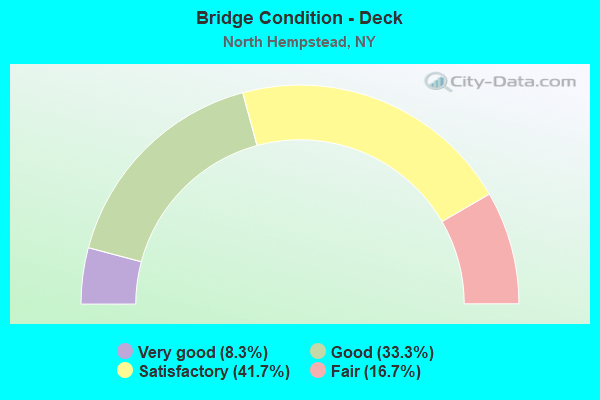
- Bridge Condition - Deck
- 8.3%Very good
- 33.3%Good
- 41.7%Satisfactory
- 16.7%Fair
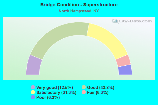
- Bridge Condition - Superstructure
- 12.5%Very good
- 43.8%Good
- 31.3%Satisfactory
- 6.3%Fair
- 6.3%Poor
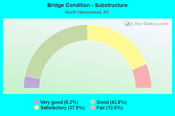
- Bridge Condition - Substructure
- 6.3%Very good
- 43.8%Good
- 37.5%Satisfactory
- 12.5%Fair
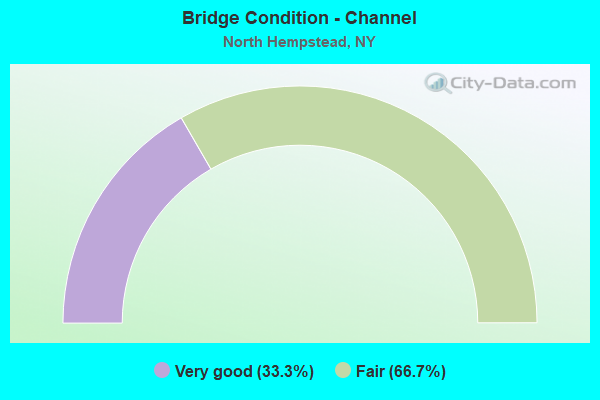
- Bridge Condition - Channel
- 33.3%Very good
- 66.7%Fair
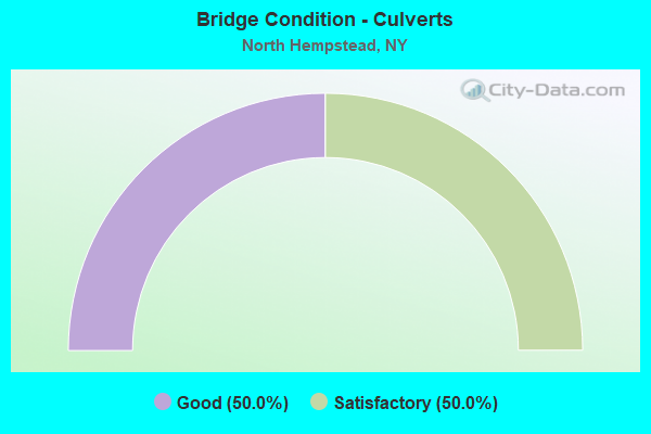
- Bridge Condition - Culverts
- 50.0%Good
- 50.0%Satisfactory
Find on map >> Show street view
Structure Number: 10377, Location: JCT. RTE.131 & GRASSE R. (Lat: 44.953561, Lng: -74.839075), Route carried "on" structure: State highway 131, Year Built: 1956, Year Reconstructed: 1987, Status: Open, Structure Length: 18.75m (61.52ft), Average Daily Traffic: 2,121 (year 2019), Truck Traffic: 10%, Average Future Daily Traffic: 2,576 (year 2040), Design Load: HS 20, Features Intersected: GRASSE RIVER
Minimum Vertical Clearance: 30+ m (98+ ft), Kilometerpoint: 19.726, Lanes on structure: 2, Base Highway Network: Yes, Owner: State Highway Agency, Approaching Roadway Width: 11.0m (36.1ft), Material/Design: Steel, Design/Construction: Girder and Floorbeam System, Number Of Spans In Main Unit: 5, Length of Maximum Span: 49.7m (163.1ft), Curb-To-Curb Width: 11.0m (36.1ft), Out-to-Out Width: 11.6m (38.1ft)
Condition: Deck: Satisfactory, Superstructure: Good, Substructure: Good, Channel: Very good, Operating Rating: 95.3 metric tons, Method Used To Determine Operating Rating: Load Factor (LF), Inventory Rating: 57.2 metric tons, Method Used To Determine Inventory Rating: Load Factor (LF), Structural Evaluation: Better than present minimum criteria, Deck Geometry: Somewhat better than minimum adequacy, Waterway Adequacy: Equal to present minimum criteria, Approach Roadway Alignment: Equal to present desirable criteria, Length Of Structure Improvement: 18.74m (61.48ft), Designated Inspection Frequency: Every 24 months, Critical Feature Inspection Frequency: Every 24 months, Underwater Inspection Frequency: Every 60 months, Inspection Date: September 2021, Critical Feature Inspection Date: September 2021, Underwater Inspection Date: August 2017, Bridge Improvement Cost: $3,903,000, Roadway Improvement Cost: $2,286,000, Total Project Cost: $6,189,000 ( Estimate for 2021), Deck Structure Type: Concrete Cast-file-Place, Wearing Surface/Protective System: Wearing Surface: Integral Concrete, Deck Protection: Epoxy Coated Reinforcing
Find on map >> Show street view
Structure Number: 1049049, Location: I495 - 4.1 MI NE QNS CL (Lat: 40.784800, Lng: -73.648903), Route carried "on" structure: Interstate 495, Year Built: 2006, Status: Open, Structure Length: 2.65m (8.69ft), Average Daily Traffic: 175,260 (year 2020), Truck Traffic: 13%, Average Future Daily Traffic: 184,023 (year 2040), Design Load: HS 25 or greater, Features Intersected: WILLIS AVENUE
Minimum Vertical Clearance: 30+ m (98+ ft), Kilometerpoint: 6.870, Lanes on structure: 8, Lanes under structure: 6, Base Highway Network: Yes, Owner: State Highway Agency, Approaching Roadway Width: 39.9m (130.9ft), Skew: 21 degrees, Material/Design: Steel, Design/Construction: Stringer/Multi-beam, Number Of Spans In Main Unit: 1, Length of Maximum Span: 25.3m (83.0ft), Curb-To-Curb Width: 40.0m (131.2ft), Out-to-Out Width: 41.8m (137.1ft)
Condition: Deck: Good, Superstructure: Very good, Substructure: Satisfactory, Inventory Rating: 70.8 metric tons, Method Used To Determine Inventory Rating: Load Factor (LF), Structural Evaluation: Equal to present minimum criteria, Deck Geometry: Superior to present desirable criteria, Underclear: Meets minimum limits, Approach Roadway Alignment: Equal to present desirable criteria, Length Of Structure Improvement: 2.65m (8.69ft), Designated Inspection Frequency: Every 24 months, Critical Feature Inspection Frequency: Every 24 months, Inspection Date: May 2020, Critical Feature Inspection Date: May 2020, Bridge Improvement Cost: $7,526,000, Roadway Improvement Cost: $4,407,000, Total Project Cost: $11,933,000 ( Estimate for 2021), Deck Structure Type: Concrete Cast-file-Place, Wearing Surface/Protective System: Wearing Surface: Integral Concrete, Deck Protection: Epoxy Coated Reinforcing
Find on map >> Show street view
Structure Number: 1056629, Location: AT EAST MEADOW-N OF SSP (Lat: 40.717892, Lng: -73.580664), Route carried "on" structure: Other road 908E, Year Built: 1955, Status: Open, Structure Length: 1.01m (3.31ft), Average Daily Traffic: 107,132 (year 2018), Truck Traffic: 1%, Average Future Daily Traffic: 127,433 (year 2040), Design Load: HS 20, Features Intersected: EAST MEADOW BROOK
Minimum Vertical Clearance: 30+ m (98+ ft), Kilometerpoint: 14.127, Lanes on structure: 6, Base Highway Network: Yes, Owner: State Highway Agency, Approaching Roadway Width: 24.4m (80.1ft), Skew: 23 degrees, Material/Design: Concrete, Design/Construction: Culvert, Number Of Spans In Main Unit: 3, Length of Maximum Span: 2.7m (8.9ft)
Condition: Channel: Fair, Culverts: Good, Inventory Rating: 61.7 metric tons, Method Used To Determine Inventory Rating: Load Factor (LF), Structural Evaluation: Better than present minimum criteria, Waterway Adequacy: Meets minimum limits, Approach Roadway Alignment: Equal to present desirable criteria, Length Of Structure Improvement: 1.00m (3.28ft), Designated Inspection Frequency: Every 24 months, Inspection Date: August 2021, Bridge Improvement Cost: $1,971,000, Roadway Improvement Cost: $1,154,000, Total Project Cost: $3,125,000 ( Estimate for 2021)
Find on map >> Show street view
Structure Number: 1057399, Location: RTE 25B+NSP WB (Lat: 40.759933, Lng: -73.623453), Route carried "on" structure: Alternate State highway 25B, Year Built: 1958, Status: Open, Structure Length: 2.16m (7.09ft), Average Daily Traffic: 11,438 (year 2020), Truck Traffic: 3%, Average Future Daily Traffic: 13,197 (year 2040), Design Load: HS 20, Features Intersected: RTE 908G
Minimum Vertical Clearance: 30+ m (98+ ft), Kilometerpoint: 7.047, Lanes on structure: 4, Lanes under structure: 4, Base Highway Network: Yes, Owner: State Highway Agency, Approaching Roadway Width: 17.1m (56.1ft), Skew: 21 degrees, Material/Design: Concrete, Design/Construction: Arch - Deck, Number Of Spans In Main Unit: 1, Length of Maximum Span: 19.8m (65.0ft), Curb or Sidewalk Widths: Left: 2.1m (6.9ft), Right: 2.0m (6.6ft), Curb-To-Curb Width: 17.1m (56.1ft), Out-to-Out Width: 23.7m (77.8ft)
Condition: Superstructure: Good, Substructure: Good, Operating Rating: 61.7 metric tons, Method Used To Determine Operating Rating: Load Factor (LF), Inventory Rating: 44.5 metric tons, Method Used To Determine Inventory Rating: Load Factor (LF), Structural Evaluation: Better than present minimum criteria, Deck Geometry: Somewhat better than minimum adequacy, Underclear: High priority of corrective action, Approach Roadway Alignment: Equal to present desirable criteria, Length Of Structure Improvement: 2.16m (7.09ft), Designated Inspection Frequency: Every 24 months, Inspection Date: March 2021, Bridge Improvement Cost: $4,039,000, Roadway Improvement Cost: $2,365,000, Total Project Cost: $6,404,000 ( Estimate for 2021), Wearing Surface/Protective System: Wearing Surface: Bituminous, Membrane: Preformed Fabric
Find on map >> Show street view
Structure Number: 1058059, Location: NSP-3.7 MI NE QNS CL (Lat: 40.781800, Lng: -73.649500), Route carried "on" structure: State highway 908G, Year Built: 1968, Status: Open, Structure Length: 2.68m (8.79ft), Average Daily Traffic: 122,461 (year 2018), Average Future Daily Traffic: 145,667 (year 2040), Design Load: HS 20, Features Intersected: WILLIS AVENUE
Minimum Vertical Clearance: 30+ m (98+ ft), Kilometerpoint: 6.098, Lanes on structure: 8, Lanes under structure: 5, Base Highway Network: Yes, Owner: State Highway Agency, Approaching Roadway Width: 33.2m (108.9ft), Skew: 21 degrees, Material/Design: Steel, Design/Construction: Stringer/Multi-beam, Number Of Spans In Main Unit: 1, Length of Maximum Span: 25.6m (84.0ft), Curb or Sidewalk Widths: Left: 4.4m (14.4ft), Right: 0.7m (2.3ft), Curb-To-Curb Width: 33.1m (108.6ft), Out-to-Out Width: 40.1m (131.6ft)
Condition: Deck: Good, Superstructure: Satisfactory, Substructure: Satisfactory, Operating Rating: 58.1 metric tons, Method Used To Determine Operating Rating: Load Factor (LF), Inventory Rating: 34.5 metric tons, Method Used To Determine Inventory Rating: Load Factor (LF), Structural Evaluation: Equal to present minimum criteria, Deck Geometry: Meets minimum limits, Underclear: Meets minimum limits, Approach Roadway Alignment: Equal to present desirable criteria, Length Of Structure Improvement: 2.68m (8.79ft), Designated Inspection Frequency: Every 24 months, Inspection Date: October 2020, Bridge Improvement Cost: $7,693,000, Roadway Improvement Cost: $4,505,000, Total Project Cost: $12,198,000 ( Estimate for 2021), Deck Structure Type: Concrete Cast-file-Place, Wearing Surface/Protective System: Wearing Surface: Monolithic Concrete
Find on map >> Show street view
Structure Number: 10586, Location: 1.3 MI SE JCT NSP & WSP (Lat: 40.756489, Lng: -73.550558), Route carried "on" structure: County highway , Year Built: 1938, Status: Open, Structure Length: 2.44m (8.01ft), Average Daily Traffic: 36,297 (year 2020), Truck Traffic: 7%, Average Future Daily Traffic: 44,093 (year 2040), Design Load: H 20, Features Intersected: 908T 908T03011120 NB, RT, Facility Carried by Structure: OLD COUNTRY ROAD
Minimum Vertical Clearance: 30+ m (98+ ft), Kilometerpoint: 8.721, Lanes on structure: 4, Lanes under structure: 4, Owner: State Highway Agency, Approaching Roadway Width: 13.4m (44.0ft), Skew: 20 degrees, Material/Design: Concrete, Design/Construction: Arch - Deck, Number Of Spans In Main Unit: 1, Length of Maximum Span: 22.2m (72.8ft), Curb or Sidewalk Widths: Left: 1.5m (4.9ft), Right: 1.5m (4.9ft), Curb-To-Curb Width: 13.4m (44.0ft), Out-to-Out Width: 21.0m (68.9ft)
Condition: Superstructure: Good, Substructure: Good, Operating Rating: 61.3 metric tons, Method Used To Determine Operating Rating: Field evaluation and documented engineering judgment, Inventory Rating: 23.7 metric tons, Method Used To Determine Inventory Rating: Field evaluation and documented engineering judgment, Structural Evaluation: Somewhat better than minimum adequacy, Deck Geometry: High priority of replacement, Underclear: High priority of corrective action, Approach Roadway Alignment: Equal to present desirable criteria, Length Of Structure Improvement: 2.43m (7.97ft), Designated Inspection Frequency: Every 24 months, Inspection Date: March 2021, Bridge Improvement Cost: $3,975,000, Roadway Improvement Cost: $2,328,000, Total Project Cost: $6,303,000 ( Estimate for 2021), Wearing Surface/Protective System: Wearing Surface: Bituminous
Find on map >> Show street view
Structure Number: 1058619, Location: 1 MI SE JCT NSP + WSP (Lat: 40.761128, Lng: -73.553631), Route carried "on" structure: State highway 908T, Year Built: 1938, Status: Open, Structure Length: 1.98m (6.50ft), Average Daily Traffic: 63,133 (year 2019), Average Future Daily Traffic: 75,096 (year 2040), Design Load: H 20, Features Intersected: LONG ISLAND- M.L.
Minimum Vertical Clearance: 30+ m (98+ ft), Kilometerpoint: 19.903, Lanes on structure: 4, Base Highway Network: Yes, Owner: State Highway Agency, Approaching Roadway Width: 17.1m (56.1ft), Skew: 21 degrees, Material/Design: Concrete, Design/Construction: Frame, Number Of Spans In Main Unit: 1, Length of Maximum Span: 18.2m (59.7ft), Curb or Sidewalk Widths: Left: 0.0m, Right: 1.3m (4.3ft), Curb-To-Curb Width: 17.1m (56.1ft), Out-to-Out Width: 21.0m (68.9ft)
Condition: Deck: Fair, Superstructure: Fair, Substructure: Satisfactory, Operating Rating: 55.9 metric tons, Method Used To Determine Operating Rating: Field evaluation and documented engineering judgment, Inventory Rating: 20.3 metric tons, Method Used To Determine Inventory Rating: Field evaluation and documented engineering judgment, Structural Evaluation: Somewhat better than minimum adequacy, Deck Geometry: High priority of corrective action, Underclear: Meets minimum limits, Approach Roadway Alignment: Equal to present desirable criteria, Length Of Structure Improvement: 1.98m (6.50ft), Designated Inspection Frequency: Every 24 months, Inspection Date: September 2021, Bridge Improvement Cost: $3,426,000, Roadway Improvement Cost: $2,006,000, Total Project Cost: $5,432,000 ( Estimate for 2021), Wearing Surface/Protective System: Wearing Surface: Monolithic Concrete
Find on map >> Show street view
Structure Number: 105862, Location: .8 MI SE JCT NSP & WSP (Lat: 40.763433, Lng: -73.555564), Route carried "on" structure: County highway , Year Built: 1938, Status: Open, Structure Length: 2.56m (8.40ft), Average Daily Traffic: 9,078 (year 2020), Truck Traffic: 4%, Average Future Daily Traffic: 11,027 (year 2040), Design Load: H 20, Features Intersected: 908T908T03011126 SB, RTE, Facility Carried by Structure: PROSPECT AVENUE
Minimum Vertical Clearance: 30+ m (98+ ft), Kilometerpoint: 1.191, Lanes on structure: 4, Lanes under structure: 4, Owner: State Highway Agency, Approaching Roadway Width: 12.2m (40.0ft), Skew: 1 degrees, Material/Design: Concrete, Design/Construction: Arch - Deck, Number Of Spans In Main Unit: 1, Length of Maximum Span: 22.8m (74.8ft), Curb or Sidewalk Widths: Left: 1.8m (5.9ft), Right: 1.5m (4.9ft), Curb-To-Curb Width: 12.2m (40.0ft), Out-to-Out Width: 16.4m (53.8ft)
Condition: Superstructure: Satisfactory, Substructure: Good, Operating Rating: 62.1 metric tons, Method Used To Determine Operating Rating: Field evaluation and documented engineering judgment, Inventory Rating: 23.9 metric tons, Method Used To Determine Inventory Rating: Field evaluation and documented engineering judgment, Structural Evaluation: Somewhat better than minimum adequacy, Deck Geometry: High priority of replacement, Underclear: High priority of corrective action, Approach Roadway Alignment: Equal to present desirable criteria, Length Of Structure Improvement: 2.56m (8.40ft), Designated Inspection Frequency: Every 24 months, Inspection Date: May 2021, Bridge Improvement Cost: $3,253,000, Roadway Improvement Cost: $1,905,000, Total Project Cost: $5,159,000 ( Estimate for 2021), Wearing Surface/Protective System: Wearing Surface: Bituminous, Membrane: Preformed Fabric
Find on map >> Show street view
Structure Number: 105929, Location: AT EAST MEADOW-N OF SSP (Lat: 40.743625, Lng: -73.611717), Route carried "on" structure: County highway , Year Built: 1956, Year Reconstructed: 1992, Status: Open, Structure Length: 3.57m (11.71ft), Average Daily Traffic: 43,457 (year 2020), Truck Traffic: 3%, Average Future Daily Traffic: 52,791 (year 2040), Design Load: HS 20, Features Intersected: 908E 908E03011117, N/B,, Facility Carried by Structure: OLD COUNTRY ROAD
Minimum Vertical Clearance: 30+ m (98+ ft), Kilometerpoint: 3.347, Lanes on structure: 8, Lanes under structure: 8, Owner: State Highway Agency, Approaching Roadway Width: 28.0m (91.9ft), Skew: 30 degrees, Material/Design: Concrete continuous, Design/Construction: Frame, Number Of Spans In Main Unit: 2, Length of Maximum Span: 16.4m (53.8ft), Curb or Sidewalk Widths: Left: 1.2m (3.9ft), Right: 2.4m (7.9ft), Curb-To-Curb Width: 28.0m (91.9ft), Out-to-Out Width: 33.8m (110.9ft)
Condition: Deck: Satisfactory, Superstructure: Satisfactory, Substructure: Good, Operating Rating: 79.6 metric tons, Method Used To Determine Operating Rating: Field evaluation and documented engineering judgment, Inventory Rating: 19.6 metric tons, Method Used To Determine Inventory Rating: Field evaluation and documented engineering judgment, Structural Evaluation: Meets minimum limits, Deck Geometry: High priority of replacement, Underclear: High priority of corrective action, Approach Roadway Alignment: Equal to present desirable criteria, Length Of Structure Improvement: 3.56m (11.68ft), Designated Inspection Frequency: Every 24 months, Inspection Date: August 2021, Bridge Improvement Cost: $5,982,000, Roadway Improvement Cost: $3,503,000, Total Project Cost: $9,485,000 ( Estimate for 2021), Wearing Surface/Protective System: Wearing Surface: Bituminous, Membrane: Other
Find on map >> Show street view
Structure Number: 1059309, Location: AT EAST MEADOW-N OF SSP (Lat: 40.748983, Lng: -73.615242), Route carried "on" structure: State highway 908E, Year Built: 1956, Year Reconstructed: 1989, Status: Open, Structure Length: 3.66m (12.01ft), Average Daily Traffic: 79,573 (year 2020), Average Future Daily Traffic: 94,652 (year 2040), Design Load: HS 20, Features Intersected: WESTBURY AVENUE
Minimum Vertical Clearance: 30+ m (98+ ft), Kilometerpoint: 19.565, Lanes on structure: 7, Lanes under structure: 3, Base Highway Network: Yes, Owner: State Highway Agency, Approaching Roadway Width: 35.7m (117.1ft), Skew: 24 degrees, Material/Design: Steel, Design/Construction: Stringer/Multi-beam, Number Of Spans In Main Unit: 1, Length of Maximum Span: 35.3m (115.8ft), Curb-To-Curb Width: 35.6m (116.8ft), Out-to-Out Width: 37.2m (122.0ft)
Condition: Deck: Satisfactory, Superstructure: Good, Substructure: Satisfactory, Operating Rating: 77.1 metric tons, Method Used To Determine Operating Rating: Load Factor (LF), Inventory Rating: 46.3 metric tons, Method Used To Determine Inventory Rating: Load Factor (LF), Structural Evaluation: Equal to present minimum criteria, Deck Geometry: Superior to present desirable criteria, Underclear: Meets minimum limits, Approach Roadway Alignment: Equal to present desirable criteria, Length Of Structure Improvement: 3.65m (11.98ft), Designated Inspection Frequency: Every 24 months, Inspection Date: March 2020, Bridge Improvement Cost: $10,502,000, Roadway Improvement Cost: $6,150,000, Total Project Cost: $16,652,000 ( Estimate for 2021), Deck Structure Type: Concrete Cast-file-Place, Wearing Surface/Protective System: Wearing Surface: Integral Concrete, Deck Protection: Epoxy Coated Reinforcing
Find on map >> Show street view
Structure Number: 15237, Location: .4M SE RTE 25 & NSP (Lat: 40.754500, Lng: -73.616367), Route carried "on" structure: Ramp Other road , Year Built: 1990, Status: Open, Structure Length: 5.06m (16.60ft), Truck Traffic: 3%, Design Load: HS 20, Features Intersected: MSP N/B TO NSP W/B, Facility Carried by Structure: NSP W/B TO MSP S/B
Minimum Vertical Clearance: 30+ m (98+ ft), Kilometerpoint: 1.448, Lanes on structure: 2, Lanes under structure: 2, Owner: State Highway Agency, Approaching Roadway Width: 11.0m (36.1ft), Skew: 5 degrees, Material/Design: Steel, Design/Construction: Stringer/Multi-beam, Number Of Spans In Main Unit: 1, Length of Maximum Span: 49.3m (161.7ft), Curb-To-Curb Width: 10.8m (35.4ft), Out-to-Out Width: 11.8m (38.7ft)
Condition: Deck: Very good, Superstructure: Very good, Substructure: Good, Operating Rating: 89.8 metric tons, Method Used To Determine Operating Rating: Load Factor (LF), Inventory Rating: 41.7 metric tons, Method Used To Determine Inventory Rating: Load Factor (LF), Structural Evaluation: Better than present minimum criteria, Deck Geometry: Better than present minimum criteria, Underclear: High priority of corrective action, Approach Roadway Alignment: Equal to present desirable criteria, Length Of Structure Improvement: 5.05m (16.57ft), Designated Inspection Frequency: Every 24 months, Inspection Date: November 2021, Bridge Improvement Cost: $3,721,000, Roadway Improvement Cost: $2,179,000, Total Project Cost: $5,900,000 ( Estimate for 2021), Deck Structure Type: Concrete Cast-file-Place, Wearing Surface/Protective System: Wearing Surface: Integral Concrete, Deck Protection: Epoxy Coated Reinforcing
Find on map >> Show street view
Structure Number: 220003, Location: NW OF PORT WASHINGTON (Lat: 40.845433, Lng: -73.710881), Route carried "on" structure: Other road , Year Built: 1911, Status: Open, Structure Length: 0.76m (2.49ft), Average Daily Traffic: 2,989 (year 2017), Truck Traffic: 5%, Average Future Daily Traffic: 3,631 (year 2040), Features Intersected: MAINT FACILITY, Facility Carried by Structure: SANDS POINT ROAD
Minimum Vertical Clearance: 30+ m (98+ ft), Kilometerpoint: 0.354, Lanes on structure: 2, Owner: Town or Township Highway Agency, Approaching Roadway Width: 9.1m (29.9ft), Material/Design: Concrete, Design/Construction: Arch - Deck, Number Of Spans In Main Unit: 1, Length of Maximum Span: 7.3m (24.0ft), Curb or Sidewalk Widths: Left: 0.0m, Right: 2.1m (6.9ft), Curb-To-Curb Width: 9.1m (29.9ft), Out-to-Out Width: 15.5m (50.9ft)
Condition: Superstructure: Satisfactory, Substructure: Fair, Operating Rating: 52.3 metric tons, Method Used To Determine Operating Rating: Field evaluation and documented engineering judgment, Inventory Rating: 22.0 metric tons, Method Used To Determine Inventory Rating: Field evaluation and documented engineering judgment, Structural Evaluation: Somewhat better than minimum adequacy, Deck Geometry: Meets minimum limits, Approach Roadway Alignment: Equal to present desirable criteria, Length Of Structure Improvement: 0.76m (2.49ft), Designated Inspection Frequency: Every 24 months, Inspection Date: May 2020, Bridge Improvement Cost: $927,000, Roadway Improvement Cost: $543,000, Total Project Cost: $1,470,000 ( Estimate for 2021), Wearing Surface/Protective System: Wearing Surface: Bituminous
Find on map >> Show street view
Structure Number: 226105, Location: 0.8 MI EAST OF WESTBURY (Lat: 40.756250, Lng: -73.574081), Route carried "on" structure: Other road , Year Built: 1988, Status: Open, Structure Length: 2.44m (8.01ft), Average Daily Traffic: 9,393 (year 2020), Truck Traffic: 16%, Average Future Daily Traffic: 11,621 (year 2040), Design Load: HS 20, Features Intersected: LIRR MAIN LINE, Facility Carried by Structure: GRAND BLVD
Minimum Vertical Clearance: 30+ m (98+ ft), Kilometerpoint: 0.434, Lanes on structure: 2, Owner: Town or Township Highway Agency, Approaching Roadway Width: 11.3m (37.1ft), Skew: 4 degrees, Material/Design: Steel, Design/Construction: Stringer/Multi-beam, Number Of Spans In Main Unit: 1, Length of Maximum Span: 23.7m (77.8ft), Curb or Sidewalk Widths: Left: 1.6m (5.2ft), Right: 1.6m (5.2ft), Curb-To-Curb Width: 11.4m (37.4ft), Out-to-Out Width: 15.2m (49.9ft)
Condition: Deck: Good, Superstructure: Good, Substructure: Good, Operating Rating: 57.3 metric tons, Method Used To Determine Operating Rating: Load and Resistance Factor Rating (LRFR) rating reported by rating factor(RF) method using HL-93 loadings, Inventory Rating: 44.4 metric tons, Method Used To Determine Inventory Rating: Load and Resistance Factor Rating (LRFR) rating reported by rating factor(RF) method using HL-93 loadings, Structural Evaluation: Better than present minimum criteria, Deck Geometry: Meets minimum limits, Underclear: High priority of corrective action, Approach Roadway Alignment: Equal to present desirable criteria, Length Of Structure Improvement: 2.43m (7.97ft), Designated Inspection Frequency: Every 24 months, Inspection Date: August 2020, Bridge Improvement Cost: $3,191,000, Roadway Improvement Cost: $1,868,000, Total Project Cost: $5,059,000 ( Estimate for 2021), Deck Structure Type: Concrete Precast Panels, Wearing Surface/Protective System: Wearing Surface: Integral Concrete
Find on map >> Show street view
Structure Number: 22612, Location: 0.2 MI SW OF MANHASSET ST (Lat: 40.795342, Lng: -73.702325), Route carried "on" structure: Other road , Year Built: 2000, Status: Open, Structure Length: 1.55m (5.09ft), Average Daily Traffic: 1,166 (year 2020), Truck Traffic: 3%, Average Future Daily Traffic: 1,442 (year 2040), Design Load: HS 20, Features Intersected: LONG ISLAND-PW BR, Facility Carried by Structure: MANHASSET AVENUE
Minimum Vertical Clearance: 32.69m (107.25ft), Kilometerpoint: 0.322, Lanes on structure: 2, Owner: Local Agency, Maintenance Responsibility: Town or Township Highway Agency, Approaching Roadway Width: 7.6m (24.9ft), Skew: 1 degrees, Material/Design: Prestressed concrete, Design/Construction: Box Beam or Girders - Multiple, Number Of Spans In Main Unit: 1, Length of Maximum Span: 14.9m (48.9ft), Curb or Sidewalk Widths: Left: 1.4m (4.6ft), Right: 1.4m (4.6ft), Curb-To-Curb Width: 7.6m (24.9ft), Out-to-Out Width: 11.3m (37.1ft)
Condition: Deck: Good, Superstructure: Good, Substructure: Very good, Operating Rating: 94.3 metric tons, Method Used To Determine Operating Rating: Load Factor (LF), Inventory Rating: 46.3 metric tons, Method Used To Determine Inventory Rating: Load Factor (LF), Structural Evaluation: Better than present minimum criteria, Deck Geometry: Meets minimum limits, Underclear: High priority of corrective action, Approach Roadway Alignment: Equal to present desirable criteria, Length Of Structure Improvement: 1.55m (5.09ft), Designated Inspection Frequency: Every 24 months, Inspection Date: July 2020, Bridge Improvement Cost: $1,107,000, Roadway Improvement Cost: $648,000, Total Project Cost: $1,755,000 ( Estimate for 2021), Wearing Surface/Protective System: Wearing Surface: Monolithic Concrete
Find on map >> Show street view
Structure Number: 226121, Location: .5 MILE NE OF MANHASSET (Lat: 40.801581, Lng: -73.694794), Route carried "on" structure: Other road , Year Built: 1898, Status: Posted for load, Structure Length: 2.41m (7.91ft), Average Daily Traffic: 1,047 (year 2017), Truck Traffic: 1%, Average Future Daily Traffic: 1,466 (year 2037), Design Load: H 20, Features Intersected: LONG ISLAND-PT WS, Facility Carried by Structure: BRIDGE ROAD
Minimum Vertical Clearance: 2.59m (8.50ft), Kilometerpoint: 0.579, Lanes on structure: 2, Owner: Town or Township Highway Agency, Approaching Roadway Width: 6.4m (21.0ft), Skew: 2 degrees, Material/Design: Steel, Design/Construction: Stringer/Multi-beam, Number Of Spans In Main Unit: 3, Length of Maximum Span: 7.6m (24.9ft), Curb or Sidewalk Widths: Left: 1.2m (3.9ft), Right: 0.0m, Curb-To-Curb Width: 6.3m (20.7ft), Out-to-Out Width: 7.8m (25.6ft)
Condition: Deck: Satisfactory, Superstructure: Poor, Substructure: Fair, Operating Rating: 14.5 metric tons, Method Used To Determine Operating Rating: Allowable Stress (AS), Inventory Rating: 10.0 metric tons, Method Used To Determine Inventory Rating: Allowable Stress (AS), Structural Evaluation: High priority of corrective action, Deck Geometry: High priority of replacement, Underclear: High priority of corrective action, Approach Roadway Alignment: Meets minimum limits, Bridge Posting: Required (Relationship of Operating Rating to Maximum Legal Load: > 39.9% below), Length Of Structure Improvement: 2.40m (7.87ft), Designated Inspection Frequency: Every 12 months, Critical Feature Inspection Frequency: Every 12 months, Inspection Date: August 2021, Critical Feature Inspection Date: August 2021, Bridge Improvement Cost: $850,000, Roadway Improvement Cost: $498,000, Total Project Cost: $1,348,000 ( Estimate for 2021), Deck Structure Type: Open Grating, Wearing Surface/Protective System: Wearing Surface: Other
Find on map >> Show street view
Structure Number: 336458, Location: IN MANHASSET (Lat: 40.796964, Lng: -73.699458), Route carried "on" structure: City street , Year Built: 1900, Status: Posted for load, Structure Length: 2.38m (7.81ft), Average Daily Traffic: 12,649 (year 2020), Truck Traffic: 3%, Average Future Daily Traffic: 15,366 (year 2040), Design Load: HS 20, Features Intersected: LIRR -Port Wash. Br., Facility Carried by Structure: PLANDOME ROAD
Minimum Vertical Clearance: 30+ m (98+ ft), Kilometerpoint: 0.467, Lanes on structure: 4, Owner: Town or Township Highway Agency, Approaching Roadway Width: 16.5m (54.1ft), Skew: 2 degrees, Material/Design: Steel, Design/Construction: Stringer/Multi-beam, Number Of Spans In Main Unit: 3, Length of Maximum Span: 9.7m (31.8ft), Curb or Sidewalk Widths: Left: 2.4m (7.9ft), Right: 2.4m (7.9ft), Curb-To-Curb Width: 16.5m (54.1ft), Out-to-Out Width: 21.7m (71.2ft)
Condition: Deck: Fair, Superstructure: Satisfactory, Substructure: Satisfactory, Operating Rating: 40.8 metric tons, Method Used To Determine Operating Rating: Load Factor (LF), Inventory Rating: 14.5 metric tons, Method Used To Determine Inventory Rating: Load Factor (LF), Structural Evaluation: High priority of corrective action, Deck Geometry: Meets minimum limits, Underclear: High priority of corrective action, Approach Roadway Alignment: Equal to present desirable criteria, Bridge Posting: Required (Relationship of Operating Rating to Maximum Legal Load: > 39.9% below), Length Of Structure Improvement: 2.37m (7.78ft), Designated Inspection Frequency: Every 12 months, Inspection Date: August 2021, Bridge Improvement Cost: $1,968,000, Roadway Improvement Cost: $1,153,000, Total Project Cost: $3,121,000 ( Estimate for 2021), Deck Structure Type: Concrete Cast-file-Place, Wearing Surface/Protective System: Wearing Surface: Bituminous
Find on map >> Show street view
Structure Number: 336459, Location: .4 MI S OF PT WASHINGTON (Lat: 40.825169, Lng: -73.686283), Route carried "on" structure: Other road , Year Built: 1925, Year Reconstructed: 1991, Status: Open, Structure Length: 5.46m (17.91ft), Average Daily Traffic: 8,360 (year 2017), Truck Traffic: 2%, Average Future Daily Traffic: 11,704 (year 2037), Design Load: HS 20, Features Intersected: LONG ISLAND-PT WS, Facility Carried by Structure: WILLOWDALE AVENUE
Minimum Vertical Clearance: 30+ m (98+ ft), Kilometerpoint: 0.257, Lanes on structure: 2, Owner: Town or Township Highway Agency, Approaching Roadway Width: 7.9m (25.9ft), Material/Design: Steel continuous, Design/Construction: Stringer/Multi-beam, Number Of Spans In Main Unit: 7, Length of Maximum Span: 9.4m (30.8ft), Curb or Sidewalk Widths: Left: 1.5m (4.9ft), Right: 1.5m (4.9ft), Curb-To-Curb Width: 7.9m (25.9ft), Out-to-Out Width: 11.6m (38.1ft)
Condition: Deck: Satisfactory, Superstructure: Good, Substructure: Satisfactory, Operating Rating: 18.8 metric tons, Method Used To Determine Operating Rating: Load and Resistance Factor Rating (LRFR) rating reported by rating factor(RF) method using HL-93 loadings, Inventory Rating: 14.3 metric tons, Method Used To Determine Inventory Rating: Load and Resistance Factor Rating (LRFR) rating reported by rating factor(RF) method using HL-93 loadings, Structural Evaluation: High priority of corrective action, Deck Geometry: High priority of replacement, Underclear: High priority of corrective action, Approach Roadway Alignment: Meets minimum limits, Length Of Structure Improvement: 5.45m (17.88ft), Designated Inspection Frequency: Every 24 months, Inspection Date: September 2021, Bridge Improvement Cost: $2,826,000, Roadway Improvement Cost: $1,655,000, Total Project Cost: $4,481,000 ( Estimate for 2021), Deck Structure Type: Concrete Cast-file-Place, Wearing Surface/Protective System: Wearing Surface: Integral Concrete, Deck Protection: Epoxy Coated Reinforcing
Find on map >> Show street view
Structure Number: 337024, Location: .1Mi W of MeadowBrookPkwy (Lat: 40.728889, Lng: -73.583294), Route carried "on" structure: ServiceCounty highway , Year Built: 1970, Status: Open, Structure Length: 0.85m (2.79ft), Average Daily Traffic: 17,064 (year 2019), Truck Traffic: 5%, Average Future Daily Traffic: 20,729 (year 2040), Features Intersected: East Meadow Brook, Facility Carried by Structure: Charles Lindbergh
Minimum Vertical Clearance: 30+ m (98+ ft), Kilometerpoint: 0.306, Lanes on structure: 10, Owner: County Highway Agency, Approaching Roadway Width: 36.6m (120.1ft), Skew: 22 degrees, Material/Design: Concrete, Design/Construction: Culvert, Number Of Spans In Main Unit: 3, Length of Maximum Span: 2.7m (8.9ft)
Condition: Channel: Fair, Culverts: Satisfactory, Structural Evaluation: Equal to present minimum criteria, Waterway Adequacy: Equal to present desirable criteria, Approach Roadway Alignment: Equal to present desirable criteria, Length Of Structure Improvement: 0.85m (2.79ft), Designated Inspection Frequency: Every 24 months, Inspection Date: April 2020, Bridge Improvement Cost: $1,074,000, Roadway Improvement Cost: $629,000, Total Project Cost: $1,703,000 ( Estimate for 2021), Wearing Surface/Protective System: Wearing Surface: Bituminous
Find on map >> Show street view
Structure Number: 10378, Location: .3 MI S JCT RTS 135 & SSP (Lat: 40.696803, Lng: -73.492414), Route carried "under" structure: State highway 135, Year Built: 1965, Structure Length: 0. m, Average Daily Traffic: 48,549 (year 2002), Features Intersected: 135 135 03011033, RTE 13, Facility Carried by Structure: PED BR S OF SSP
Minimum Vertical Clearance: 4.57m (14.99ft), Kilometerpoint: 3.878, Lanes under structure: 3, Material/Design: Steel, Design/Construction: Stringer/Multi-beam, Length of Maximum Span: 34.7m (113.8ft)
Find on map >> Show street view
Structure Number: 1049049, Location: I495 - 4.1 MI NE QNS CL (Lat: 40.784800, Lng: -73.648903), Route carried "under" structure: Other road , Year Built: 2006, Structure Length: 0. m, Average Daily Traffic: 16,000 (year 1976), Features Intersected: WILLIS AVENUE, Facility Carried by Structure: RTE I495
Minimum Vertical Clearance: 4.52m (14.83ft), Kilometerpoint: 0.000, Lanes on structure: 8, Lanes under structure: 6, Material/Design: Steel, Design/Construction: Stringer/Multi-beam, Length of Maximum Span: 25.3m (83.0ft)
Find on map >> Show street view
Structure Number: 1057399, Location: RTE 25B+NSP WB (Lat: 40.759933, Lng: -73.623453), Route carried "under" structure: State highway 908G, Year Built: 1958, Structure Length: 0. m, Average Daily Traffic: 167,824 (year 2002), Features Intersected: RTE 908G, Facility Carried by Structure: RTE 25B
Minimum Vertical Clearance: 4.45m (14.60ft), Kilometerpoint: 10.362, Lanes on structure: 4, Lanes under structure: 4, Material/Design: Concrete, Design/Construction: Arch - Deck, Length of Maximum Span: 19.8m (65.0ft)
Find on map >> Show street view
Structure Number: 1058059, Location: NSP-3.7 MI NE QNS CL (Lat: 40.781800, Lng: -73.649500), Route carried "under" structure: County highway , Year Built: 1968, Structure Length: 0. m, Average Daily Traffic: 14,500 (year 1976), Features Intersected: WILLIS AVENUE, Facility Carried by Structure: RTE 908G
Minimum Vertical Clearance: 4.80m (15.75ft), Kilometerpoint: 0.000, Lanes on structure: 8, Lanes under structure: 5, Material/Design: Steel, Design/Construction: Stringer/Multi-beam, Length of Maximum Span: 25.6m (84.0ft)
Find on map >> Show street view
Structure Number: 10586, Location: 1.3 MI SE JCT NSP & WSP (Lat: 40.756489, Lng: -73.550558), Route carried "under" structure: State highway 908T, Year Built: 1938, Structure Length: 0. m, Average Daily Traffic: 63,859 (year 2002), Features Intersected: 908T 908T03011120 NB, RT, Facility Carried by Structure: OLD COUNTRY ROAD
Minimum Vertical Clearance: 4.11m (13.48ft), Kilometerpoint: 19.051, Lanes on structure: 4, Lanes under structure: 2, Material/Design: Concrete, Design/Construction: Arch - Deck, Length of Maximum Span: 22.2m (72.8ft)
Find on map >> Show street view
Structure Number: 105862, Location: .8 MI SE JCT NSP & WSP (Lat: 40.763433, Lng: -73.555564), Route carried "under" structure: Other road 908T, Year Built: 1938, Structure Length: 0. m, Average Daily Traffic: 60,671 (year 2002), Features Intersected: 908T908T03011126 SB, RTE, Facility Carried by Structure: PROSPECT AVENUE
Minimum Vertical Clearance: 4.21m (13.81ft), Kilometerpoint: 19.968, Lanes on structure: 4, Lanes under structure: 2, Material/Design: Concrete, Design/Construction: Arch - Deck, Length of Maximum Span: 22.8m (74.8ft)
Find on map >> Show street view
Structure Number: 105929, Location: AT EAST MEADOW-N OF SSP (Lat: 40.743625, Lng: -73.611717), Route carried "under" structure: State highway 908E, Year Built: 1956, Structure Length: 0. m, Average Daily Traffic: 136,583 (year 2002), Features Intersected: 908E 908E03011117, N/B,, Facility Carried by Structure: OLD COUNTRY ROAD
Minimum Vertical Clearance: 3.86m (12.66ft), Kilometerpoint: 18.793, Lanes on structure: 8, Lanes under structure: 4, Material/Design: Concrete continuous, Design/Construction: Frame, Length of Maximum Span: 16.4m (53.8ft)
Find on map >> Show street view
Structure Number: 1059309, Location: AT EAST MEADOW-N OF SSP (Lat: 40.748983, Lng: -73.615242), Route carried "under" structure: County highway , Year Built: 1956, Structure Length: 0. m, Average Daily Traffic: 10,000 (year 1976), Features Intersected: WESTBURY AVENUE, Facility Carried by Structure: RTE 908E
Minimum Vertical Clearance: 4.37m (14.34ft), Kilometerpoint: 0.000, Lanes on structure: 7, Lanes under structure: 3, Material/Design: Steel, Design/Construction: Stringer/Multi-beam, Length of Maximum Span: 35.3m (115.8ft)
Find on map >> Show street view
Structure Number: 15237, Location: .4M SE RTE 25 & NSP (Lat: 40.754500, Lng: -73.616367), Route carried "under" structure: Other road , Year Built: 1990, Structure Length: 0. m, Average Daily Traffic: 40,918 (year 2005), Features Intersected: MSP N/B TO NSP W/B, Facility Carried by Structure: NSP W/B TO MSP S/B
Minimum Vertical Clearance: 4.45m (14.60ft), Kilometerpoint: 0.000, Lanes on structure: 2, Lanes under structure: 2, Material/Design: Steel, Design/Construction: Stringer/Multi-beam, Length of Maximum Span: 49.3m (161.7ft)
Find on map >> Show street view
Structure Number: 1523711, Location: 0.4MI E RTS 25 & NSP (Lat: 40.755828, Lng: -73.615533), Route carried "under" structure: State highway , Year Built: 1989, Structure Length: 0. m, Average Daily Traffic: 75,700 (year 1980), Features Intersected: 908G 908G03011070, Facility Carried by Structure: RTE 908G
Minimum Vertical Clearance: 4.19m (13.75ft), Kilometerpoint: 11.263, Lanes on structure: 3, Lanes under structure: 2, Material/Design: Steel, Design/Construction: Stringer/Multi-beam, Length of Maximum Span: 51.5m (169.0ft)
Find on map >> Show street view
Structure Number: 704905, Location: RTE 495-4.4 MI NE QNS CL (Lat: 40.784822, Lng: -73.643281), Route carried "under" structure: Interstate 495, Year Built: 1955, Structure Length: 0. m, Average Daily Traffic: 222,948 (year 2002), Features Intersected: RTE I495, Facility Carried by Structure: LONG ISLAND RR
Minimum Vertical Clearance: 4.78m (15.68ft), Kilometerpoint: 7.385, Lanes under structure: 10, Material/Design: Steel continuous, Design/Construction: Girder and Floorbeam System, Length of Maximum Span: 22.0m (72.2ft)
Find on map >> Show street view
Structure Number: 70566, Location: NSP-4.0 MI NE QNS CL (Lat: 40.781483, Lng: -73.643231), Route carried "under" structure: Other road 908G, Year Built: 1968, Structure Length: 0. m, Average Daily Traffic: 140,921 (year 2002), Features Intersected: RTE 908G, Facility Carried by Structure: LIRR-OYS BAY BRCH
Minimum Vertical Clearance: 4.39m (14.40ft), Kilometerpoint: 6.726, Lanes under structure: 3, Material/Design: Steel, Design/Construction: Girder and Floorbeam System, Length of Maximum Span: 20.7m (67.9ft)
Find on map >> Show street view
Structure Number: 705665, Location: AT EAST MEADOW-N OF SSP (Lat: 40.746869, Lng: -73.613386), Route carried "under" structure: Other road 908E, Year Built: 1956, Structure Length: 0. m, Average Daily Traffic: 126,952 (year 2002), Features Intersected: RTE 908E, Facility Carried by Structure: LIRR-HEMPSTD BRCH
Minimum Vertical Clearance: 3.81m (12.50ft), Kilometerpoint: 17.812, Lanes under structure: 7, Material/Design: Steel, Design/Construction: Girder and Floorbeam System, Length of Maximum Span: 18.2m (59.7ft)
Find on map >> Show street view
Structure Number: 705666, Location: AT EAST MEADOW-N OF SSP (Lat: 40.746939, Lng: -73.613244), Route carried "under" structure: Other road 908E, Year Built: 1955, Structure Length: 0. m, Average Daily Traffic: 136,409 (year 2002), Features Intersected: RTE 908E, Facility Carried by Structure: LIRR-HEMPSTD BRCH
Minimum Vertical Clearance: 4.11m (13.48ft), Kilometerpoint: 19.179, Lanes under structure: 6, Material/Design: Steel, Design/Construction: Stringer/Multi-beam, Length of Maximum Span: 15.2m (49.9ft)
Find on map >> Show street view
Structure Number: 70576, Location: NSP-4.0 MI NE QNS CL (Lat: 40.781289, Lng: -73.643217), Route carried "under" structure: Other road 908G, Year Built: 1934, Structure Length: 0. m, Average Daily Traffic: 140,921 (year 2002), Features Intersected: RTE 908G, Facility Carried by Structure: LIRR-OYS BAY BRCH
Minimum Vertical Clearance: 4.37m (14.34ft), Kilometerpoint: 6.726, Lanes under structure: 4, Material/Design: Steel, Design/Construction: Girder and Floorbeam System, Length of Maximum Span: 19.5m (64.0ft)
Find on map >> Show street view
Structure Number: 770916, Location: 1.2 MI EAST OF MINEOLA (Lat: 40.746017, Lng: -73.617144), Route carried "under" structure: County highway , Year Built: 1942, Structure Length: 0. m, Average Daily Traffic: 26,500 (year 1977), Features Intersected: GLEN COVE RD, Facility Carried by Structure: LIRR MAIN LINE
Minimum Vertical Clearance: 4.31m (14.14ft), Kilometerpoint: 0.000, Lanes under structure: 4, Material/Design: Steel, Design/Construction: Girder and Floorbeam System, Length of Maximum Span: 18.2m (59.7ft)
Find on map >> Show street view
Structure Number: 770917, Location: 1.0 MI WEST OF WESTBURY (Lat: 40.748742, Lng: -73.605681), Route carried "under" structure: Other road , Year Built: 1953, Structure Length: 0. m, Average Daily Traffic: 2,500 (year 2021), Features Intersected: CHERRY LANE, Facility Carried by Structure: LIRR MAIN LINE
Minimum Vertical Clearance: 4.19m (13.75ft), Kilometerpoint: 0.000, Lanes under structure: 2, Material/Design: Steel, Design/Construction: Girder and Floorbeam System, Length of Maximum Span: 17.3m (56.8ft)