Bridge Statistics for North Hills, New York (NY)
Condition, Traffic, Stress, Structural Evaluation, Project Costs
- National Bridge Inventory (NBI) Statistics
- 14Number of bridges
- 82ft / 25.4mTotal length
- $68,172,000Total costs
- 1,271,876Total average daily traffic
- 24,350Total average daily truck traffic
- National Bridge Inventory (NBI) Registered Bridges for North Hills
- No street view available for this location
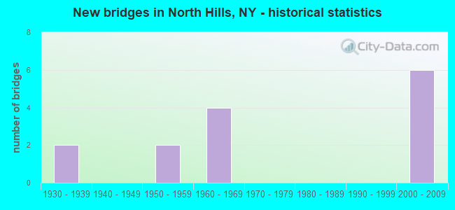
- New bridges - historical statistics
- 21930-1939
- 21950-1959
- 41960-1969
- 62000-2009
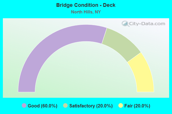
- Bridge Condition - Deck
- 60.0%Good
- 20.0%Satisfactory
- 20.0%Fair
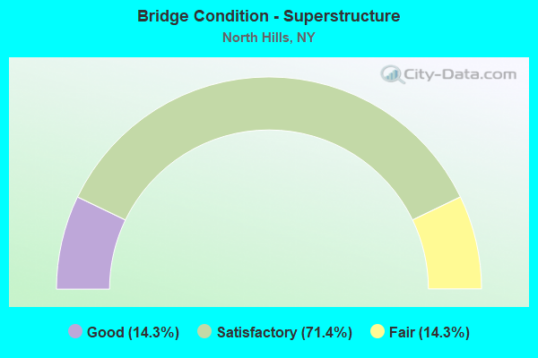
- Bridge Condition - Superstructure
- 14.3%Good
- 71.4%Satisfactory
- 14.3%Fair
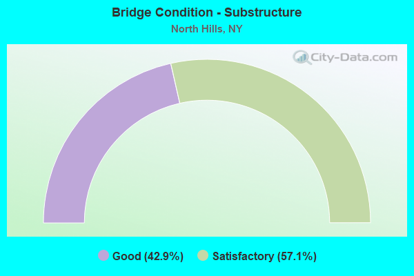
- Bridge Condition - Substructure
- 42.9%Good
- 57.1%Satisfactory
Find on map >> Show street view
Structure Number: 1049019, Location: I495 - 1.6 MI NE QNS C.LI (Lat: 40.768547, Lng: -73.691614), Route carried "on" structure: County highway , Year Built: 2002, Status: Open, Structure Length: 4.27m (14.01ft), Average Daily Traffic: 26,799 (year 2019), Truck Traffic: 5%, Average Future Daily Traffic: 30,920 (year 2040), Design Load: HS 25 or greater, Features Intersected: 495I495I03021018, W/B, R, Facility Carried by Structure: NEW HYDE PARK RD
Minimum Vertical Clearance: 30+ m (98+ ft), Kilometerpoint: 6.999, Lanes on structure: 5, Lanes under structure: 8, Owner: State Highway Agency, Approaching Roadway Width: 21.9m (71.9ft), Skew: 20 degrees, Material/Design: Prestressed concrete continuous, Design/Construction: Box Beam or Girders - Multiple, Number Of Spans In Main Unit: 2, Length of Maximum Span: 20.4m (66.9ft), Curb or Sidewalk Widths: Left: 1.6m (5.2ft), Right: 1.6m (5.2ft), Curb-To-Curb Width: 21.9m (71.9ft), Out-to-Out Width: 26.3m (86.3ft)
Condition: Deck: Good, Superstructure: Good, Substructure: Good, Operating Rating: 68.9 metric tons, Method Used To Determine Operating Rating: Load Factor (LF), Inventory Rating: 33.6 metric tons, Method Used To Determine Inventory Rating: Load Factor (LF), Structural Evaluation: Better than present minimum criteria, Deck Geometry: Somewhat better than minimum adequacy, Underclear: High priority of corrective action, Approach Roadway Alignment: High priority of corrective action, Length Of Structure Improvement: 4.26m (13.98ft), Designated Inspection Frequency: Every 24 months, Inspection Date: January 2020, Bridge Improvement Cost: $4,493,000, Roadway Improvement Cost: $2,631,000, Total Project Cost: $7,125,000 ( Estimate for 2021), Deck Structure Type: Concrete Cast-file-Place, Wearing Surface/Protective System: Wearing Surface: Integral Concrete, Deck Protection: Epoxy Coated Reinforcing
Find on map >> Show street view
Structure Number: 1049029, Location: I495 - 2.8 MI NE QNS CO L (Lat: 40.774258, Lng: -73.670906), Route carried "on" structure: County highway , Year Built: 2000, Status: Open, Structure Length: 4.57m (14.99ft), Average Daily Traffic: 16,037 (year 2020), Truck Traffic: 3%, Average Future Daily Traffic: 19,481 (year 2040), Design Load: HS 25 or greater, Features Intersected: 495I495I03021029, W/B, R, Facility Carried by Structure: SHELTER ROCK ROAD
Minimum Vertical Clearance: 30+ m (98+ ft), Kilometerpoint: 5.068, Lanes on structure: 7, Lanes under structure: 8, Owner: State Highway Agency, Approaching Roadway Width: 28.4m (93.2ft), Material/Design: Prestressed concrete continuous, Design/Construction: Box Beam or Girders - Multiple, Number Of Spans In Main Unit: 2, Length of Maximum Span: 22.0m (72.2ft), Curb or Sidewalk Widths: Left: 1.9m (6.2ft), Right: 1.9m (6.2ft), Curb-To-Curb Width: 28.4m (93.2ft), Out-to-Out Width: 33.4m (109.6ft)
Condition: Deck: Good, Superstructure: Satisfactory, Substructure: Good, Operating Rating: 82.6 metric tons, Method Used To Determine Operating Rating: Load Factor (LF), Inventory Rating: 48.1 metric tons, Method Used To Determine Inventory Rating: Load Factor (LF), Structural Evaluation: Equal to present minimum criteria, Deck Geometry: Somewhat better than minimum adequacy, Underclear: High priority of corrective action, Approach Roadway Alignment: Equal to present desirable criteria, Length Of Structure Improvement: 4.57m (14.99ft), Designated Inspection Frequency: Every 24 months, Inspection Date: January 2020, Bridge Improvement Cost: $6,173,000, Roadway Improvement Cost: $3,615,000, Total Project Cost: $9,788,000 ( Estimate for 2021), Deck Structure Type: Concrete Cast-file-Place, Wearing Surface/Protective System: Wearing Surface: Integral Concrete, Deck Protection: Epoxy Coated Reinforcing
Find on map >> Show street view
Structure Number: 1049039, Location: I495 -3.4 MI NE QNS CO LN (Lat: 40.779553, Lng: -73.661622), Route carried "on" structure: Interstate 495, Year Built: 1958, Year Reconstructed: 2000, Status: Open, Structure Length: 2.99m (9.81ft), Average Daily Traffic: 161,461 (year 2020), Truck Traffic: 13%, Average Future Daily Traffic: 169,534 (year 2040), Design Load: HS 20+Mod, Features Intersected: SEARINGTOWN ROAD
Minimum Vertical Clearance: 30+ m (98+ ft), Kilometerpoint: 5.632, Lanes on structure: 8, Lanes under structure: 6, Base Highway Network: Yes, Owner: State Highway Agency, Approaching Roadway Width: 42.4m (139.1ft), Skew: 21 degrees, Material/Design: Concrete continuous, Design/Construction: Frame, Number Of Spans In Main Unit: 2, Length of Maximum Span: 13.7m (44.9ft), Curb-To-Curb Width: 42.4m (139.1ft), Out-to-Out Width: 46.0m (150.9ft)
Condition: Deck: Satisfactory, Superstructure: Satisfactory, Substructure: Good, Operating Rating: 55.3 metric tons, Method Used To Determine Operating Rating: Load Factor (LF), Inventory Rating: 32.7 metric tons, Method Used To Determine Inventory Rating: Load Factor (LF), Structural Evaluation: Equal to present minimum criteria, Deck Geometry: Superior to present desirable criteria, Underclear: Meets minimum limits, Approach Roadway Alignment: Equal to present minimum criteria, Length Of Structure Improvement: 2.98m (9.78ft), Designated Inspection Frequency: Every 24 months, Inspection Date: June 2020, Bridge Improvement Cost: $8,380,000, Roadway Improvement Cost: $4,907,000, Total Project Cost: $13,287,000 ( Estimate for 2021), Wearing Surface/Protective System: Wearing Surface: Bituminous
Find on map >> Show street view
Structure Number: 105702, Location: 1.3 MI NE QUEENS CO LINE (Lat: 40.765581, Lng: -73.690206), Route carried "on" structure: County highway , Year Built: 1968, Status: Open, Structure Length: 2.74m (8.99ft), Average Daily Traffic: 32,067 (year 2016), Truck Traffic: 2%, Average Future Daily Traffic: 36,998 (year 2040), Design Load: HS 20, Features Intersected: RTE 908G, Facility Carried by Structure: NEW HYDE PARK RD
Minimum Vertical Clearance: 30+ m (98+ ft), Kilometerpoint: 6.645, Lanes on structure: 4, Lanes under structure: 3, Owner: State Highway Agency, Approaching Roadway Width: 15.8m (51.8ft), Skew: 2 degrees, Material/Design: Concrete, Design/Construction: Arch - Deck, Number Of Spans In Main Unit: 1, Length of Maximum Span: 26.2m (86.0ft), Curb or Sidewalk Widths: Left: 1.7m (5.6ft), Right: 1.5m (4.9ft), Curb-To-Curb Width: 15.8m (51.8ft), Out-to-Out Width: 20.7m (67.9ft)
Condition: Superstructure: Satisfactory, Substructure: Satisfactory, Operating Rating: 91.3 metric tons, Method Used To Determine Operating Rating: Field evaluation and documented engineering judgment, Inventory Rating: 32.7 metric tons, Method Used To Determine Inventory Rating: Field evaluation and documented engineering judgment, Structural Evaluation: Equal to present minimum criteria, Deck Geometry: Meets minimum limits, Underclear: High priority of corrective action, Approach Roadway Alignment: Equal to present desirable criteria, Length Of Structure Improvement: 2.74m (8.99ft), Designated Inspection Frequency: Every 24 months, Inspection Date: January 2020, Bridge Improvement Cost: $4,568,000, Roadway Improvement Cost: $2,675,000, Total Project Cost: $7,243,000 ( Estimate for 2021), Wearing Surface/Protective System: Wearing Surface: Bituminous
Find on map >> Show street view
Structure Number: 105802, Location: NSP-1.3 MI NE QUEENS C.LN (Lat: 40.765378, Lng: -73.690153), Route carried "on" structure: County highway , Year Built: 1932, Status: Open, Structure Length: 2.83m (9.28ft), Average Daily Traffic: 32,067 (year 2016), Truck Traffic: 2%, Average Future Daily Traffic: 36,998 (year 2040), Design Load: HS 20, Features Intersected: RTE 908G, Facility Carried by Structure: NEW HYDE PARK RD
Minimum Vertical Clearance: 30+ m (98+ ft), Kilometerpoint: 6.629, Lanes on structure: 5, Lanes under structure: 3, Owner: State Highway Agency, Approaching Roadway Width: 15.8m (51.8ft), Skew: 2 degrees, Material/Design: Concrete, Design/Construction: Arch - Deck, Number Of Spans In Main Unit: 1, Length of Maximum Span: 19.5m (64.0ft), Curb or Sidewalk Widths: Left: 1.7m (5.6ft), Right: 1.5m (4.9ft), Curb-To-Curb Width: 15.8m (51.8ft), Out-to-Out Width: 20.7m (67.9ft)
Condition: Superstructure: Fair, Substructure: Satisfactory, Operating Rating: 80.9 metric tons, Method Used To Determine Operating Rating: Field evaluation and documented engineering judgment, Inventory Rating: 19.6 metric tons, Method Used To Determine Inventory Rating: Field evaluation and documented engineering judgment, Structural Evaluation: Meets minimum limits, Deck Geometry: High priority of replacement, Underclear: High priority of corrective action, Approach Roadway Alignment: Equal to present desirable criteria, Length Of Structure Improvement: 2.83m (9.28ft), Designated Inspection Frequency: Every 24 months, Inspection Date: June 2020, Bridge Improvement Cost: $4,981,000, Roadway Improvement Cost: $2,917,000, Total Project Cost: $7,898,000 ( Estimate for 2021), Wearing Surface/Protective System: Wearing Surface: Bituminous
Find on map >> Show street view
Structure Number: 1058049, Location: NSP - 3.1 MI NE QUEENS C (Lat: 40.779019, Lng: -73.661047), Route carried "on" structure: State highway 908G, Year Built: 1968, Status: Open, Structure Length: 3.51m (11.52ft), Average Daily Traffic: 122,461 (year 2018), Average Future Daily Traffic: 145,667 (year 2040), Design Load: HS 20, Features Intersected: SEARINGTOWN RD
Minimum Vertical Clearance: 30+ m (98+ ft), Kilometerpoint: 5.117, Lanes on structure: 6, Lanes under structure: 6, Base Highway Network: Yes, Owner: State Highway Agency, Approaching Roadway Width: 25.3m (83.0ft), Skew: 23 degrees, Material/Design: Steel, Design/Construction: Stringer/Multi-beam, Number Of Spans In Main Unit: 1, Length of Maximum Span: 33.5m (109.9ft), Curb or Sidewalk Widths: Left: 4.4m (14.4ft), Right: 4.4m (14.4ft), Curb-To-Curb Width: 25.2m (82.7ft), Out-to-Out Width: 35.8m (117.5ft)
Condition: Deck: Fair, Superstructure: Satisfactory, Substructure: Satisfactory, Operating Rating: 41.8 metric tons, Method Used To Determine Operating Rating: Load and Resistance Factor Rating (LRFR) rating reported by rating factor(RF) method using HL-93 loadings, Inventory Rating: 32.1 metric tons, Method Used To Determine Inventory Rating: Load and Resistance Factor Rating (LRFR) rating reported by rating factor(RF) method using HL-93 loadings, Structural Evaluation: Equal to present minimum criteria, Deck Geometry: Meets minimum limits, Underclear: Meets minimum limits, Approach Roadway Alignment: Equal to present desirable criteria, Length Of Structure Improvement: 3.50m (11.48ft), Designated Inspection Frequency: Every 24 months, Inspection Date: June 2020, Bridge Improvement Cost: $8,531,000, Roadway Improvement Cost: $4,996,000, Total Project Cost: $13,527,000 ( Estimate for 2021), Deck Structure Type: Concrete Cast-file-Place, Wearing Surface/Protective System: Wearing Surface: Monolithic Concrete
Find on map >> Show street view
Structure Number: 107756, Location: NSP 2.5 MI NE QUEENS CL (Lat: 40.773517, Lng: -73.670592), Route carried "on" structure: County highway , Year Built: 2000, Status: Open, Structure Length: 4.51m (14.80ft), Average Daily Traffic: 8,651 (year 2020), Truck Traffic: 3%, Average Future Daily Traffic: 10,509 (year 2040), Design Load: HS 25 or greater, Features Intersected: 908G908G03011026, RTE 90, Facility Carried by Structure: SHELTER ROCK ROAD
Minimum Vertical Clearance: 30+ m (98+ ft), Kilometerpoint: 4.940, Lanes on structure: 7, Lanes under structure: 7, Owner: State Highway Agency, Approaching Roadway Width: 28.3m (92.8ft), Skew: 20 degrees, Material/Design: Prestressed concrete continuous, Design/Construction: Box Beam or Girders - Multiple, Number Of Spans In Main Unit: 2, Length of Maximum Span: 23.4m (76.8ft), Curb or Sidewalk Widths: Left: 1.8m (5.9ft), Right: 1.8m (5.9ft), Curb-To-Curb Width: 28.4m (93.2ft), Out-to-Out Width: 33.1m (108.6ft)
Condition: Deck: Good, Superstructure: Satisfactory, Substructure: Satisfactory, Operating Rating: 30.8 metric tons, Method Used To Determine Operating Rating: Load and Resistance Factor Rating (LRFR) rating reported by rating factor(RF) method using HL-93 loadings, Inventory Rating: 15.2 metric tons, Method Used To Determine Inventory Rating: Load and Resistance Factor Rating (LRFR) rating reported by rating factor(RF) method using HL-93 loadings, Structural Evaluation: High priority of corrective action, Deck Geometry: Somewhat better than minimum adequacy, Underclear: High priority of corrective action, Approach Roadway Alignment: Equal to present desirable criteria, Length Of Structure Improvement: 4.51m (14.80ft), Designated Inspection Frequency: Every 24 months, Inspection Date: July 2020, Bridge Improvement Cost: $5,868,000, Roadway Improvement Cost: $3,436,000, Total Project Cost: $9,304,000 ( Estimate for 2021), Deck Structure Type: Concrete Cast-file-Place, Wearing Surface/Protective System: Wearing Surface: Monolithic Concrete, Deck Protection: Epoxy Coated Reinforcing
Find on map >> Show street view
Structure Number: 1049019, Location: I495 - 1.6 MI NE QNS C.LI (Lat: 40.768547, Lng: -73.691614), Route carried "under" structure: Interstate 495, Year Built: 2002, Structure Length: 0. m, Average Daily Traffic: 186,779 (year 2002), Features Intersected: 495I495I03021018, W/B, R, Facility Carried by Structure: NEW HYDE PARK RD
Minimum Vertical Clearance: 4.98m (16.34ft), Kilometerpoint: 2.767, Lanes on structure: 5, Lanes under structure: 4, Material/Design: Prestressed concrete continuous, Design/Construction: Box Beam or Girders - Multiple, Length of Maximum Span: 20.4m (66.9ft)
Find on map >> Show street view
Structure Number: 1049029, Location: I495 - 2.8 MI NE QNS CO L (Lat: 40.774258, Lng: -73.670906), Route carried "under" structure: Interstate 495, Year Built: 2000, Structure Length: 0. m, Average Daily Traffic: 186,779 (year 2002), Features Intersected: 495I495I03021029, W/B, R, Facility Carried by Structure: SHELTER ROCK ROAD
Minimum Vertical Clearance: 5.05m (16.57ft), Kilometerpoint: 4.682, Lanes on structure: 7, Lanes under structure: 4, Material/Design: Prestressed concrete continuous, Design/Construction: Box Beam or Girders - Multiple, Length of Maximum Span: 22.0m (72.2ft)
Find on map >> Show street view
Structure Number: 1049039, Location: I495 -3.4 MI NE QNS CO LN (Lat: 40.779553, Lng: -73.661622), Route carried "under" structure: Other road , Year Built: 1958, Structure Length: 0. m, Average Daily Traffic: 18,000 (year 1976), Features Intersected: SEARINGTOWN ROAD, Facility Carried by Structure: RTE I495
Minimum Vertical Clearance: 4.78m (15.68ft), Kilometerpoint: 0.000, Lanes on structure: 8, Lanes under structure: 6, Material/Design: Concrete continuous, Design/Construction: Frame, Length of Maximum Span: 13.7m (44.9ft)
Find on map >> Show street view
Structure Number: 105702, Location: 1.3 MI NE QUEENS CO LINE (Lat: 40.765581, Lng: -73.690206), Route carried "under" structure: Other road 908G, Year Built: 1968, Structure Length: 0. m, Average Daily Traffic: 155,113 (year 2002), Features Intersected: RTE 908G, Facility Carried by Structure: NEW HYDE PARK RD
Minimum Vertical Clearance: 5.00m (16.40ft), Kilometerpoint: 2.124, Lanes on structure: 4, Lanes under structure: 3, Material/Design: Concrete, Design/Construction: Arch - Deck, Length of Maximum Span: 26.2m (86.0ft)
Find on map >> Show street view
Structure Number: 105802, Location: NSP-1.3 MI NE QUEENS C.LN (Lat: 40.765378, Lng: -73.690153), Route carried "under" structure: State highway 908G, Year Built: 1932, Structure Length: 0. m, Average Daily Traffic: 155,113 (year 2002), Features Intersected: RTE 908G, Facility Carried by Structure: NEW HYDE PARK RD
Minimum Vertical Clearance: 4.39m (14.40ft), Kilometerpoint: 2.124, Lanes on structure: 5, Lanes under structure: 3, Material/Design: Concrete, Design/Construction: Arch - Deck, Length of Maximum Span: 19.5m (64.0ft)
Find on map >> Show street view
Structure Number: 1058049, Location: NSP - 3.1 MI NE QUEENS C (Lat: 40.779019, Lng: -73.661047), Route carried "under" structure: County highway , Year Built: 1968, Structure Length: 0. m, Average Daily Traffic: 10,500 (year 1976), Features Intersected: SEARINGTOWN RD, Facility Carried by Structure: RTE 908G
Minimum Vertical Clearance: 4.57m (14.99ft), Kilometerpoint: 0.000, Lanes on structure: 6, Lanes under structure: 6, Material/Design: Steel, Design/Construction: Stringer/Multi-beam, Length of Maximum Span: 33.5m (109.9ft)
Find on map >> Show street view
Structure Number: 107756, Location: NSP 2.5 MI NE QUEENS CL (Lat: 40.773517, Lng: -73.670592), Route carried "under" structure: State highway 908G, Year Built: 2000, Structure Length: 0. m, Average Daily Traffic: 160,049 (year 2002), Features Intersected: 908G908G03011026, RTE 90, Facility Carried by Structure: SHELTER ROCK ROAD
Minimum Vertical Clearance: 4.88m (16.01ft), Kilometerpoint: 4.119, Lanes on structure: 7, Lanes under structure: 3, Material/Design: Prestressed concrete continuous, Design/Construction: Box Beam or Girders - Multiple, Length of Maximum Span: 23.4m (76.8ft)