Bridge Statistics for North Olmsted, Ohio (OH)
Condition, Traffic, Stress, Structural Evaluation, Project Costs
- National Bridge Inventory (NBI) Statistics
- 32Number of bridges
- 348ft / 106mTotal length
- 843,972Total average daily traffic
- 49,631Total average daily truck traffic
- National Bridge Inventory (NBI) Registered Bridges for North Olmsted
- No street view available for this location
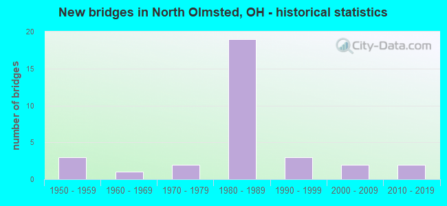
- New bridges - historical statistics
- 31950-1959
- 11960-1969
- 21970-1979
- 191980-1989
- 31990-1999
- 22000-2009
- 22010-2019
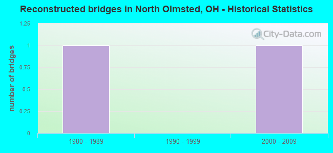
- Reconstructed bridges - Historical Statistics
- 11980-1989
- 01990-1999
- 12000-2009
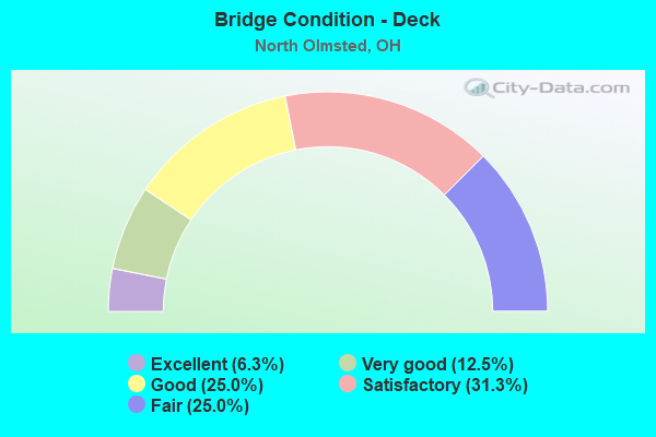
- Bridge Condition - Deck
- 6.3%Excellent
- 12.5%Very good
- 25.0%Good
- 31.3%Satisfactory
- 25.0%Fair
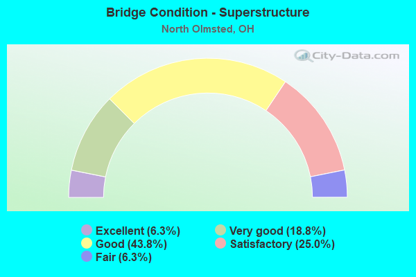
- Bridge Condition - Superstructure
- 6.3%Excellent
- 18.8%Very good
- 43.8%Good
- 25.0%Satisfactory
- 6.3%Fair
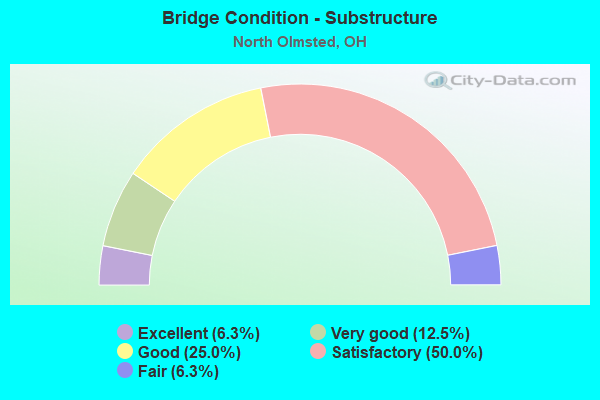
- Bridge Condition - Substructure
- 6.3%Excellent
- 12.5%Very good
- 25.0%Good
- 50.0%Satisfactory
- 6.3%Fair
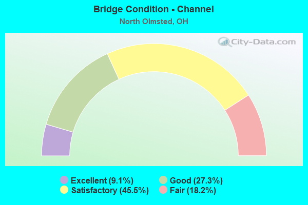
- Bridge Condition - Channel
- 9.1%Excellent
- 27.3%Good
- 45.5%Satisfactory
- 18.2%Fair
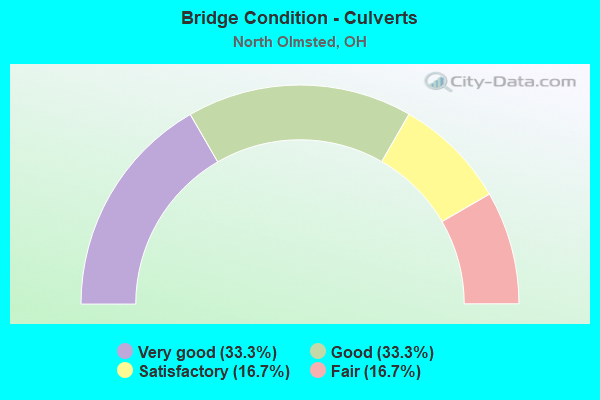
- Bridge Condition - Culverts
- 33.3%Very good
- 33.3%Good
- 16.7%Satisfactory
- 16.7%Fair
Find on map >> Show street view
Structure Number: 1810405, Location: JCT. SR-252 WITH I-480 (Lat: 41.412981, Lng: -81.902000), Route carried "on" structure: State highway 252, Year Built: 1980, Status: Open, Structure Length: 8.90m (29.20ft), Average Daily Traffic: 19,407 (year 2015), Truck Traffic: 7%, Average Future Daily Traffic: 26,937 (year 2035), Design Load: HS 20+Mod, Features Intersected: I-480 (GRT NRTHRN BLVD)
Minimum Vertical Clearance: 30+ m (98+ ft), Kilometerpoint: 6.985, Lanes on structure: 5, Lanes under structure: 8, Base Highway Network: Yes, Owner: State Highway Agency, Approaching Roadway Width: 24.4m (80.1ft), Skew: 12 degrees, Material/Design: Steel continuous, Design/Construction: Stringer/Multi-beam, Number Of Spans In Main Unit: 4, Length of Maximum Span: 27.7m (90.9ft), Curb or Sidewalk Widths: Left: 2.2m (7.2ft), Right: 2.2m (7.2ft), Curb-To-Curb Width: 24.4m (80.1ft), Out-to-Out Width: 29.3m (96.1ft)
Condition: Deck: Good, Superstructure: Good, Substructure: Fair, Operating Rating: 42.1 metric tons, Method Used To Determine Operating Rating: Load Factor (LF) rating reported by rating factor (RF) method using MS18 loading, Inventory Rating: 32.4 metric tons, Method Used To Determine Inventory Rating: Load Factor (LF) rating reported by rating factor (RF) method using MS18 loading, Structural Evaluation: Somewhat better than minimum adequacy, Deck Geometry: Superior to present desirable criteria, Underclear: Somewhat better than minimum adequacy, Approach Roadway Alignment: Equal to present desirable criteria, Designated Inspection Frequency: Every 12 months, Inspection Date: March 2021, Deck Structure Type: Concrete Cast-file-Place, Wearing Surface/Protective System: Wearing Surface: Monolithic Concrete, Deck Protection: Epoxy Coated Reinforcing
Find on map >> Show street view
Structure Number: 1814001, Location: 3.2 MI. W. OF JCT. SR-252 (Lat: 41.390419, Lng: -81.956600), Route carried "on" structure: County highway 166, Year Built: 1980, Status: Open, Structure Length: 8.17m (26.80ft), Average Daily Traffic: 12,556 (year 2002), Truck Traffic: 1%, Average Future Daily Traffic: 17,428 (year 2022), Design Load: HS 20+Mod, Features Intersected: IR-480-0074, Facility Carried by Structure: BARTON RD
Minimum Vertical Clearance: 30+ m (98+ ft), Kilometerpoint: 0.697, Lanes on structure: 2, Lanes under structure: 6, Owner: State Highway Agency, Approaching Roadway Width: 8.5m (27.9ft), Skew: 3 degrees, Material/Design: Steel continuous, Design/Construction: Stringer/Multi-beam, Number Of Spans In Main Unit: 4, Length of Maximum Span: 23.8m (78.1ft), Curb or Sidewalk Widths: Left: 1.5m (4.9ft), Right: 1.5m (4.9ft), Curb-To-Curb Width: 8.5m (27.9ft), Out-to-Out Width: 12.3m (40.4ft)
Condition: Deck: Good, Superstructure: Good, Substructure: Good, Operating Rating: 42.1 metric tons, Method Used To Determine Operating Rating: Load Factor (LF) rating reported by rating factor (RF) method using MS18 loading, Inventory Rating: 32.4 metric tons, Method Used To Determine Inventory Rating: Load Factor (LF) rating reported by rating factor (RF) method using MS18 loading, Structural Evaluation: Better than present minimum criteria, Deck Geometry: Meets minimum limits, Underclear: Somewhat better than minimum adequacy, Approach Roadway Alignment: Equal to present desirable criteria, Designated Inspection Frequency: Every 24 months, Inspection Date: Febuary 2021, Deck Structure Type: Concrete Cast-file-Place, Wearing Surface/Protective System: Wearing Surface: Monolithic Concrete, Deck Protection: Epoxy Coated Reinforcing
Find on map >> Show street view
Structure Number: 1814036, Location: 2.5 MI. W. OF JCT. SR-252 (Lat: 41.395981, Lng: -81.944019), Route carried "on" structure: County highway 76, Year Built: 1980, Status: Open, Structure Length: 8.66m (28.41ft), Average Daily Traffic: 13,060 (year 2002), Truck Traffic: 3%, Average Future Daily Traffic: 18,127 (year 2022), Design Load: HS 20+Mod, Features Intersected: IR-480 (STEARNS), Facility Carried by Structure: STEARNS RD
Minimum Vertical Clearance: 30+ m (98+ ft), Kilometerpoint: 3.627, Lanes on structure: 5, Lanes under structure: 7, Base Highway Network: Yes, Owner: State Highway Agency, Approaching Roadway Width: 21.9m (71.9ft), Skew: 12 degrees, Material/Design: Steel continuous, Design/Construction: Stringer/Multi-beam, Number Of Spans In Main Unit: 4, Length of Maximum Span: 27.1m (88.9ft), Curb or Sidewalk Widths: Left: 1.5m (4.9ft), Right: 1.5m (4.9ft), Curb-To-Curb Width: 21.3m (69.9ft), Out-to-Out Width: 25.1m (82.3ft)
Condition: Deck: Good, Superstructure: Good, Substructure: Satisfactory, Operating Rating: 42.1 metric tons, Method Used To Determine Operating Rating: Load Factor (LF) rating reported by rating factor (RF) method using MS18 loading, Inventory Rating: 32.4 metric tons, Method Used To Determine Inventory Rating: Load Factor (LF) rating reported by rating factor (RF) method using MS18 loading, Structural Evaluation: Equal to present minimum criteria, Deck Geometry: Somewhat better than minimum adequacy, Underclear: Somewhat better than minimum adequacy, Approach Roadway Alignment: Equal to present desirable criteria, Designated Inspection Frequency: Every 12 months, Inspection Date: August 2021, Deck Structure Type: Concrete Cast-file-Place, Wearing Surface/Protective System: Wearing Surface: Monolithic Concrete, Deck Protection: Epoxy Coated Reinforcing
Find on map >> Show street view
Structure Number: 1814052, Location: 2.0 MI. W. OF JCT. SR-252 (Lat: 41.398581, Lng: -81.934211), Route carried "on" structure: Interstate 480, Year Built: 1980, Status: Open, Structure Length: 3.72m (12.20ft), Average Daily Traffic: 68,753 (year 2015), Truck Traffic: 5%, Average Future Daily Traffic: 95,429 (year 2035), Design Load: HS 20+Mod, Features Intersected: CR 86 (MACKENZIE RD)
Minimum Vertical Clearance: 30+ m (98+ ft), Kilometerpoint: 3.267, Lanes on structure: 6, Lanes under structure: 2, Base Highway Network: Yes, Owner: State Highway Agency, Approaching Roadway Width: 33.8m (110.9ft), Skew: 11 degrees, Material/Design: Steel continuous, Design/Construction: Stringer/Multi-beam, Number Of Spans In Main Unit: 3, Length of Maximum Span: 15.2m (49.9ft), Curb-To-Curb Width: 36.7m (120.4ft), Out-to-Out Width: 37.9m (124.3ft)
Condition: Deck: Satisfactory, Superstructure: Very good, Substructure: Very good, Operating Rating: 42.1 metric tons, Method Used To Determine Operating Rating: Allowable Stress (AS) rating reported by rating factor (RF) method using MS18 loading, Inventory Rating: 32.4 metric tons, Method Used To Determine Inventory Rating: Allowable Stress (AS) rating reported by rating factor (RF) method using MS18 loading, Structural Evaluation: Equal to present desirable criteria, Deck Geometry: Superior to present desirable criteria, Underclear: Somewhat better than minimum adequacy, Approach Roadway Alignment: Equal to present desirable criteria, Designated Inspection Frequency: Every 12 months, Inspection Date: May 2021, Deck Structure Type: Concrete Cast-file-Place, Wearing Surface/Protective System: Wearing Surface: Monolithic Concrete
Find on map >> Show street view
Structure Number: 1814079, Location: 1.2 MI. W. OF JCT. SR-252 (Lat: 41.404769, Lng: -81.921000), Route carried "on" structure: Interstate 480, Year Built: 1980, Status: Open, Structure Length: 5.55m (18.21ft), Average Daily Traffic: 68,753 (year 2015), Truck Traffic: 5%, Average Future Daily Traffic: 95,429 (year 2035), Design Load: HS 20+Mod, Features Intersected: CR 170 (FITCH RD)
Minimum Vertical Clearance: 30+ m (98+ ft), Kilometerpoint: 4.554, Lanes on structure: 6, Lanes under structure: 2, Base Highway Network: Yes, Owner: State Highway Agency, Approaching Roadway Width: 37.2m (122.0ft), Skew: 13 degrees, Material/Design: Steel continuous, Design/Construction: Stringer/Multi-beam, Number Of Spans In Main Unit: 3, Length of Maximum Span: 24.4m (80.1ft), Curb-To-Curb Width: 36.7m (120.4ft), Out-to-Out Width: 37.9m (124.3ft)
Condition: Deck: Fair, Superstructure: Good, Substructure: Satisfactory, Operating Rating: 42.1 metric tons, Method Used To Determine Operating Rating: Allowable Stress (AS) rating reported by rating factor (RF) method using MS18 loading, Inventory Rating: 32.4 metric tons, Method Used To Determine Inventory Rating: Allowable Stress (AS) rating reported by rating factor (RF) method using MS18 loading, Structural Evaluation: Equal to present minimum criteria, Deck Geometry: Superior to present desirable criteria, Underclear: High priority of corrective action, Approach Roadway Alignment: Equal to present desirable criteria, Designated Inspection Frequency: Every 12 months, Inspection Date: May 2021, Deck Structure Type: Concrete Cast-file-Place, Wearing Surface/Protective System: Wearing Surface: Monolithic Concrete, Deck Protection: Epoxy Coated Reinforcing
Find on map >> Show street view
Structure Number: 1814095, Location: .63 MI. W. OF JCT. SR-252 (Lat: 41.409019, Lng: -81.913450), Route carried "on" structure: County highway 93, Year Built: 1980, Status: Open, Structure Length: 8.99m (29.49ft), Average Daily Traffic: 9,297 (year 2016), Truck Traffic: 7%, Average Future Daily Traffic: 12,904 (year 2036), Design Load: HS 20+Mod, Features Intersected: IR-480 (BUTTERNUT RIDGE), Facility Carried by Structure: BUTTERNUT RIDGE
Minimum Vertical Clearance: 30+ m (98+ ft), Kilometerpoint: 1.363, Lanes on structure: 4, Lanes under structure: 6, Owner: State Highway Agency, Approaching Roadway Width: 15.9m (52.2ft), Skew: 4 degrees, Material/Design: Steel continuous, Design/Construction: Stringer/Multi-beam, Number Of Spans In Main Unit: 4, Length of Maximum Span: 25.9m (85.0ft), Curb or Sidewalk Widths: Left: 1.5m (4.9ft), Right: 1.5m (4.9ft), Curb-To-Curb Width: 15.9m (52.2ft), Out-to-Out Width: 19.6m (64.3ft)
Condition: Deck: Satisfactory, Superstructure: Good, Substructure: Good, Operating Rating: 42.1 metric tons, Method Used To Determine Operating Rating: Load Factor (LF) rating reported by rating factor (RF) method using MS18 loading, Inventory Rating: 32.4 metric tons, Method Used To Determine Inventory Rating: Load Factor (LF) rating reported by rating factor (RF) method using MS18 loading, Structural Evaluation: Better than present minimum criteria, Deck Geometry: Meets minimum limits, Underclear: High priority of corrective action, Approach Roadway Alignment: Equal to present desirable criteria, Designated Inspection Frequency: Every 12 months, Inspection Date: May 2021, Deck Structure Type: Concrete Cast-file-Place, Wearing Surface/Protective System: Wearing Surface: Monolithic Concrete, Deck Protection: Epoxy Coated Reinforcing
Find on map >> Show street view
Structure Number: 1814109, Location: 1.0 MI. E. OF JCT. SR-252 (Lat: 41.414950, Lng: -81.893600), Route carried "on" structure: City street COLUM, Year Built: 1980, Status: Open, Structure Length: 8.32m (27.30ft), Average Daily Traffic: 8,771 (year 2018), Truck Traffic: 7%, Average Future Daily Traffic: 12,174 (year 2038), Design Load: HS 20+Mod, Features Intersected: IR-480 (COLUMBIA)
Minimum Vertical Clearance: 30+ m (98+ ft), Kilometerpoint: 1.297, Lanes on structure: 2, Lanes under structure: 6, Owner: State Highway Agency, Approaching Roadway Width: 8.5m (27.9ft), Skew: 3 degrees, Material/Design: Steel continuous, Design/Construction: Stringer/Multi-beam, Number Of Spans In Main Unit: 4, Length of Maximum Span: 23.2m (76.1ft), Curb or Sidewalk Widths: Left: 1.5m (4.9ft), Right: 1.5m (4.9ft), Curb-To-Curb Width: 8.5m (27.9ft), Out-to-Out Width: 12.3m (40.4ft)
Condition: Deck: Fair, Superstructure: Good, Substructure: Good, Operating Rating: 42.1 metric tons, Method Used To Determine Operating Rating: Allowable Stress (AS) rating reported by rating factor (RF) method using MS18 loading, Inventory Rating: 32.4 metric tons, Method Used To Determine Inventory Rating: Allowable Stress (AS) rating reported by rating factor (RF) method using MS18 loading, Structural Evaluation: Better than present minimum criteria, Deck Geometry: Meets minimum limits, Underclear: Somewhat better than minimum adequacy, Approach Roadway Alignment: Equal to present desirable criteria, Designated Inspection Frequency: Every 12 months, Inspection Date: May 2021, Deck Structure Type: Concrete Cast-file-Place, Wearing Surface/Protective System: Wearing Surface: Monolithic Concrete, Deck Protection: Epoxy Coated Reinforcing
Find on map >> Show street view
Structure Number: 1814125, Location: 1.4 MI. E. OF JCT. SR-252 (Lat: 41.419081, Lng: -81.883439), Route carried "on" structure: Interstate 480, Year Built: 1980, Status: Open, Structure Length: 13.87m (45.51ft), Average Daily Traffic: 82,613 (year 2015), Truck Traffic: 5%, Average Future Daily Traffic: 114,667 (year 2035), Design Load: HS 20+Mod, Features Intersected: SR 17 (0162) BROOKPARK R
Minimum Vertical Clearance: 30+ m (98+ ft), Kilometerpoint: 8.063, Lanes on structure: 6, Lanes under structure: 4, Base Highway Network: Yes, Owner: State Highway Agency, Approaching Roadway Width: 36.0m (118.1ft), Skew: 16 degrees, Material/Design: Steel continuous, Design/Construction: Stringer/Multi-beam, Number Of Spans In Main Unit: 4, Length of Maximum Span: 43.9m (144.0ft), Curb-To-Curb Width: 36.7m (120.4ft), Out-to-Out Width: 37.9m (124.3ft)
Condition: Deck: Satisfactory, Superstructure: Satisfactory, Substructure: Satisfactory, Operating Rating: 42.1 metric tons, Method Used To Determine Operating Rating: Load Factor (LF) rating reported by rating factor (RF) method using MS18 loading, Inventory Rating: 32.4 metric tons, Method Used To Determine Inventory Rating: Load Factor (LF) rating reported by rating factor (RF) method using MS18 loading, Structural Evaluation: Equal to present minimum criteria, Deck Geometry: Superior to present desirable criteria, Underclear: Equal to present minimum criteria, Approach Roadway Alignment: Equal to present desirable criteria, Designated Inspection Frequency: Every 12 months, Inspection Date: September 2021, Deck Structure Type: Concrete Cast-file-Place, Wearing Surface/Protective System: Wearing Surface: Bituminous, Deck Protection: Epoxy Coated Reinforcing
Find on map >> Show street view
Structure Number: 1814133, Location: 1.1 MI. E. OF JCT. SR-252 (Lat: 41.422050, Lng: -81.877569), Route carried "on" structure: Interstate 480, Year Built: 1980, Status: Open, Structure Length: 5.61m (18.41ft), Average Daily Traffic: 82,613 (year 2018), Truck Traffic: 5%, Average Future Daily Traffic: 114,667 (year 2038), Design Load: HS 20+Mod, Features Intersected: CR 52 (CLAGUE RD)
Minimum Vertical Clearance: 30+ m (98+ ft), Kilometerpoint: 8.690, Lanes on structure: 6, Lanes under structure: 4, Base Highway Network: Yes, Owner: State Highway Agency, Approaching Roadway Width: 36.0m (118.1ft), Skew: 12 degrees, Material/Design: Steel continuous, Design/Construction: Stringer/Multi-beam, Number Of Spans In Main Unit: 4, Length of Maximum Span: 17.1m (56.1ft), Curb-To-Curb Width: 37.2m (122.0ft), Out-to-Out Width: 38.3m (125.7ft)
Condition: Deck: Very good, Superstructure: Very good, Substructure: Satisfactory, Operating Rating: 42.1 metric tons, Method Used To Determine Operating Rating: Allowable Stress (AS) rating reported by rating factor (RF) method using MS18 loading, Inventory Rating: 32.4 metric tons, Method Used To Determine Inventory Rating: Allowable Stress (AS) rating reported by rating factor (RF) method using MS18 loading, Structural Evaluation: Equal to present minimum criteria, Deck Geometry: Superior to present desirable criteria, Underclear: High priority of corrective action, Approach Roadway Alignment: Equal to present desirable criteria, Designated Inspection Frequency: Every 12 months, Inspection Date: May 2021, Deck Structure Type: Concrete Cast-file-Place, Wearing Surface/Protective System: Wearing Surface: Integral Concrete, Deck Protection: Epoxy Coated Reinforcing
Find on map >> Show street view
Structure Number: 1829041, Location: 1.8MI EAST OF SR-10 (Lat: 41.367700, Lng: -81.959550), Route carried "on" structure: County highway C0234, Year Built: 1954, Year Reconstructed: 1986, Status: Open, Structure Length: 5.91m (19.39ft), Average Daily Traffic: 1,158 (year 2015), Truck Traffic: 5%, Average Future Daily Traffic: 1,607 (year 2035), Features Intersected: I80 OHIO TPK, Facility Carried by Structure: CR 234 JENNINGS RD
Minimum Vertical Clearance: 30+ m (98+ ft), Kilometerpoint: 0.386, Lanes on structure: 2, Lanes under structure: 6, Owner: State Toll Authority, Approaching Roadway Width: 7.3m (24.0ft), Material/Design: Steel continuous, Design/Construction: Stringer/Multi-beam, Number Of Spans In Main Unit: 2, Number Of Approach Spans: 2, Length of Maximum Span: 20.1m (65.9ft), Curb or Sidewalk Widths: Left: 1.2m (3.9ft), Right: 1.2m (3.9ft), Curb-To-Curb Width: 7.3m (24.0ft), Out-to-Out Width: 10.6m (34.8ft)
Condition: Deck: Satisfactory, Superstructure: Satisfactory, Substructure: Good, Operating Rating: 38.9 metric tons, Method Used To Determine Operating Rating: Load Factor (LF) rating reported by rating factor (RF) method using MS18 loading, Inventory Rating: 22.7 metric tons, Method Used To Determine Inventory Rating: Load Factor (LF) rating reported by rating factor (RF) method using MS18 loading, Structural Evaluation: Equal to present minimum criteria, Deck Geometry: Meets minimum limits, Underclear: High priority of corrective action, Approach Roadway Alignment: Equal to present desirable criteria, Designated Inspection Frequency: Every 12 months, Inspection Date: July 2021, Deck Structure Type: Concrete Cast-file-Place, Wearing Surface/Protective System: Wearing Surface: Monolithic Concrete, Deck Protection: Epoxy Coated Reinforcing
Find on map >> Show street view
Structure Number: 1831836, Location: WEST OF MAIN STREET (Lat: 41.374261, Lng: -81.903561), Route carried "on" structure: County highway 379, Year Built: 1972, Status: Open, Structure Length: 3.72m (12.20ft), Average Daily Traffic: 3,039 (year 1998), Truck Traffic: 1%, Average Future Daily Traffic: 4,218 (year 2018), Design Load: HS 20, Features Intersected: PLUM CREEK
Minimum Vertical Clearance: 30+ m (98+ ft), Kilometerpoint: 0.145, Lanes on structure: 2, Owner: County Highway Agency, Approaching Roadway Width: 14.6m (47.9ft), Skew: 3 degrees, Material/Design: Steel continuous, Design/Construction: Stringer/Multi-beam, Number Of Spans In Main Unit: 3, Length of Maximum Span: 13.7m (44.9ft), Curb or Sidewalk Widths: Left: 1.5m (4.9ft), Right: 1.5m (4.9ft), Curb-To-Curb Width: 8.5m (27.9ft), Out-to-Out Width: 12.3m (40.4ft)
Condition: Deck: Fair, Superstructure: Good, Substructure: Satisfactory, Channel: Good, Operating Rating: 71.3 metric tons, Method Used To Determine Operating Rating: Load and Resistance Factor Rating (LRFR) rating reported by rating factor(RF) method using HL-93 loadings, Inventory Rating: 55.1 metric tons, Method Used To Determine Inventory Rating: Load and Resistance Factor Rating (LRFR) rating reported by rating factor(RF) method using HL-93 loadings, Structural Evaluation: Equal to present minimum criteria, Deck Geometry: Meets minimum limits, Waterway Adequacy: Superior to present desirable criteria, Approach Roadway Alignment: Superior to present desirable criteria, Designated Inspection Frequency: Every 12 months, Inspection Date: August 2021, Deck Structure Type: Concrete Cast-file-Place, Wearing Surface/Protective System: Wearing Surface: Integral Concrete
Find on map >> Show street view
Structure Number: 1832441, Location: 750' WEST OF JENNINGS RD (Lat: 41.372589, Lng: -81.962739), Route carried "on" structure: County highway C0027, Year Built: 2005, Status: Open, Structure Length: 0.77m (2.53ft), Average Daily Traffic: 1,949 (year 2015), Truck Traffic: 5%, Average Future Daily Traffic: 2,705 (year 2035), Design Load: HS 20, Features Intersected: SHADY DITCH (FRENCH CRK), Facility Carried by Structure: BAGLEY ROAD CR 27
Minimum Vertical Clearance: 30+ m (98+ ft), Kilometerpoint: 0.708, Lanes on structure: 2, Owner: County Highway Agency, Approaching Roadway Width: 11.0m (36.1ft), Skew: 5 degrees, Material/Design: Concrete, Design/Construction: Culvert, Number Of Spans In Main Unit: 1, Length of Maximum Span: 7.3m (24.0ft)
Condition: Channel: Fair, Culverts: Very good, Operating Rating: 77.8 metric tons, Method Used To Determine Operating Rating: Load Factor (LF) rating reported by rating factor (RF) method using MS18 loading, Inventory Rating: 45.4 metric tons, Method Used To Determine Inventory Rating: Load Factor (LF) rating reported by rating factor (RF) method using MS18 loading, Structural Evaluation: Equal to present desirable criteria, Waterway Adequacy: Equal to present desirable criteria, Approach Roadway Alignment: Superior to present desirable criteria, Designated Inspection Frequency: Every 24 months, Inspection Date: August 2021
Find on map >> Show street view
Structure Number: 1833553, Location: 2587' N OF JOHN RD (Lat: 41.404389, Lng: -81.920939), Route carried "on" structure: County highway C0170, Year Built: 1979, Status: Open, Structure Length: 0.88m (2.89ft), Average Daily Traffic: 6,081 (year 2015), Truck Traffic: 9%, Average Future Daily Traffic: 8,440 (year 2035), Design Load: H 15, Features Intersected: FITCH LATERAL, Facility Carried by Structure: FITCH ROAD CR 170
Minimum Vertical Clearance: 30+ m (98+ ft), Kilometerpoint: 3.524, Lanes on structure: 2, Owner: County Highway Agency, Approaching Roadway Width: 8.5m (27.9ft), Skew: 3 degrees, Material/Design: Concrete, Design/Construction: Culvert, Number Of Spans In Main Unit: 2, Length of Maximum Span: 4.2m (13.8ft)
Condition: Channel: Fair, Culverts: Satisfactory, Operating Rating: 42.1 metric tons, Method Used To Determine Operating Rating: Load Factor (LF) rating reported by rating factor (RF) method using MS18 loading, Inventory Rating: 32.4 metric tons, Method Used To Determine Inventory Rating: Load Factor (LF) rating reported by rating factor (RF) method using MS18 loading, Structural Evaluation: Equal to present minimum criteria, Waterway Adequacy: Better than present minimum criteria, Approach Roadway Alignment: Superior to present desirable criteria, Designated Inspection Frequency: Every 12 months, Inspection Date: August 2021
Find on map >> Show street view
Structure Number: 1834231, Location: 716 FT S OF CEDAR PT RD (Lat: 41.404661, Lng: -81.893111), Route carried "on" structure: County highway C0174, Year Built: 2009, Status: Open, Structure Length: 4.57m (14.99ft), Average Daily Traffic: 2,936 (year 2015), Truck Traffic: 5%, Average Future Daily Traffic: 4,075 (year 2035), Design Load: HS 20+Mod, Features Intersected: WEST BR ROCKY RIVER, Facility Carried by Structure: LEWIS ROAD CR 174
Minimum Vertical Clearance: 30+ m (98+ ft), Kilometerpoint: 4.683, Lanes on structure: 2, Owner: County Highway Agency, Approaching Roadway Width: 8.5m (27.9ft), Material/Design: Steel, Design/Construction: Truss - Thru, Number Of Spans In Main Unit: 1, Length of Maximum Span: 44.2m (145.0ft), Curb or Sidewalk Widths: Left: 1.5m (4.9ft), Right: 1.5m (4.9ft), Curb-To-Curb Width: 8.5m (27.9ft), Out-to-Out Width: 9.1m (29.9ft)
Condition: Deck: Very good, Superstructure: Very good, Substructure: Very good, Channel: Excellent, Operating Rating: 79.1 metric tons, Method Used To Determine Operating Rating: Load and Resistance Factor Rating (LRFR) rating reported by rating factor(RF) method using HL-93 loadings, Inventory Rating: 47.3 metric tons, Method Used To Determine Inventory Rating: Load and Resistance Factor Rating (LRFR) rating reported by rating factor(RF) method using HL-93 loadings, Structural Evaluation: Equal to present desirable criteria, Deck Geometry: Meets minimum limits, Waterway Adequacy: Superior to present desirable criteria, Approach Roadway Alignment: Superior to present desirable criteria, Designated Inspection Frequency: Every 12 months, Critical Feature Inspection Frequency: Every 24 months, Inspection Date: July 2021, Critical Feature Inspection Date: July 2021, Deck Structure Type: Concrete Cast-file-Place, Wearing Surface/Protective System: Wearing Surface: Monolithic Concrete, Deck Protection: Epoxy Coated Reinforcing
Find on map >> Show street view
Structure Number: 1834436, Location: 712 FT E OF CORP LINE (Lat: 41.396650, Lng: -81.928011), Route carried "on" structure: County highway EZBLN, Year Built: 1998, Status: Open, Structure Length: 0.76m (2.49ft), Average Daily Traffic: 1,949 (year 2015), Truck Traffic: 5%, Average Future Daily Traffic: 2,705 (year 2035), Design Load: HS 20+Mod, Features Intersected: OVER FITCH LATERAL, Facility Carried by Structure: ELIZABETH LANE
Minimum Vertical Clearance: 30+ m (98+ ft), Kilometerpoint: 0.097, Lanes on structure: 2, Owner: County Highway Agency, Approaching Roadway Width: 7.6m (24.9ft), Skew: 1 degrees, Material/Design: Aluminum, Iron, Design/Construction: Culvert, Number Of Spans In Main Unit: 1, Length of Maximum Span: 7.1m (23.3ft)
Condition: Channel: Satisfactory, Culverts: Fair, Operating Rating: 32.4 metric tons, Method Used To Determine Operating Rating: Assigned ratings based on Load and Resistance Factor Design (LRFD) reported by rating factor (RF) using HL93 loadings, Inventory Rating: 24.9 metric tons, Method Used To Determine Inventory Rating: Assigned ratings based on Load and Resistance Factor Design (LRFD) reported by rating factor (RF) using HL93 loadings, Structural Evaluation: Somewhat better than minimum adequacy, Waterway Adequacy: Equal to present desirable criteria, Approach Roadway Alignment: Equal to present minimum criteria, Designated Inspection Frequency: Every 12 months, Inspection Date: September 2021
Find on map >> Show street view
Structure Number: 1834959, Location: 1000 FT NORTH OF BAGLEY (Lat: 41.375319, Lng: -81.944269), Route carried "on" structure: County highway 76, Year Built: 2016, Status: Open, Structure Length: 7.71m (25.30ft), Average Daily Traffic: 11,610 (year 2016), Truck Traffic: 3%, Average Future Daily Traffic: 12,423 (year 2036), Design Load: HL 93, Features Intersected: NORFOLK SOUTHERN RR
Minimum Vertical Clearance: 30+ m (98+ ft), Kilometerpoint: 1.320, Lanes on structure: 2, Owner: County Highway Agency, Approaching Roadway Width: 9.1m (29.9ft), Material/Design: Prestressed concrete continuous, Design/Construction: Stringer/Multi-beam, Number Of Spans In Main Unit: 3, Length of Maximum Span: 36.6m (120.1ft), Curb or Sidewalk Widths: Left: 1.8m (5.9ft), Right: 1.8m (5.9ft), Curb-To-Curb Width: 9.1m (29.9ft), Out-to-Out Width: 11.6m (38.1ft)
Condition: Deck: Excellent, Superstructure: Excellent, Substructure: Excellent, Operating Rating: 49.6 metric tons, Method Used To Determine Operating Rating: Load and Resistance Factor Rating (LRFR) rating reported by rating factor(RF) method using HL-93 loadings, Inventory Rating: 36.9 metric tons, Method Used To Determine Inventory Rating: Load and Resistance Factor Rating (LRFR) rating reported by rating factor(RF) method using HL-93 loadings, Structural Evaluation: Superior to present desirable criteria, Deck Geometry: Meets minimum limits, Underclear: Superior to present desirable criteria, Approach Roadway Alignment: Superior to present desirable criteria, Length Of Structure Improvement: 9.27m (30.41ft), Designated Inspection Frequency: Every 24 months, Inspection Date: August 2021, Deck Structure Type: Concrete Cast-file-Place, Wearing Surface/Protective System: Wearing Surface: Monolithic Concrete, Deck Protection: Epoxy Coated Reinforcing
Find on map >> Show street view
Structure Number: 1878514, Location: 65 FT N. OF NANTUCKET DR. (Lat: 41.405181, Lng: -81.922869), Route carried "on" structure: City street REVER, Year Built: 1967, Status: Open, Structure Length: 0.90m (2.95ft), Average Daily Traffic: 500 (year 1993), Truck Traffic: 5%, Average Future Daily Traffic: 694 (year 2013), Features Intersected: ROOT DITCH
Minimum Vertical Clearance: 30+ m (98+ ft), Kilometerpoint: 0.097, Lanes on structure: 2, Owner: City or Municipal Highway Agency, Approaching Roadway Width: 7.6m (24.9ft), Skew: 2 degrees, Material/Design: Concrete, Design/Construction: Culvert, Number Of Spans In Main Unit: 2, Length of Maximum Span: 4.3m (14.1ft)
Condition: Channel: Satisfactory, Culverts: Good, Operating Rating: 81.0 metric tons, Method Used To Determine Operating Rating: Load Factor (LF) rating reported by rating factor (RF) method using MS18 loading, Inventory Rating: 48.6 metric tons, Method Used To Determine Inventory Rating: Load Factor (LF) rating reported by rating factor (RF) method using MS18 loading, Structural Evaluation: Better than present minimum criteria, Waterway Adequacy: Superior to present desirable criteria, Approach Roadway Alignment: Superior to present desirable criteria, Designated Inspection Frequency: Every 24 months, Inspection Date: August 2021
Find on map >> Show street view
Structure Number: 1878549, Location: 1600 FT S. OF BUTTERNUT R (Lat: 41.404119, Lng: -81.912039), Route carried "on" structure: City street SCANT, Year Built: 1987, Status: Open, Structure Length: 0.90m (2.95ft), Average Daily Traffic: 1,000 (year 1993), Truck Traffic: 5%, Average Future Daily Traffic: 1,388 (year 2013), Features Intersected: ROOT DITCH, Facility Carried by Structure: S CANTERBURY
Minimum Vertical Clearance: 30+ m (98+ ft), Kilometerpoint: 0.145, Lanes on structure: 2, Owner: City or Municipal Highway Agency, Approaching Roadway Width: 8.5m (27.9ft), Skew: 2 degrees, Material/Design: Concrete, Design/Construction: Culvert, Number Of Spans In Main Unit: 3, Length of Maximum Span: 3.0m (9.8ft)
Condition: Channel: Satisfactory, Culverts: Good, Operating Rating: 55.1 metric tons, Method Used To Determine Operating Rating: Load Factor (LF) rating reported by rating factor (RF) method using MS18 loading, Inventory Rating: 32.4 metric tons, Method Used To Determine Inventory Rating: Load Factor (LF) rating reported by rating factor (RF) method using MS18 loading, Structural Evaluation: Better than present minimum criteria, Waterway Adequacy: Superior to present desirable criteria, Approach Roadway Alignment: Superior to present desirable criteria, Designated Inspection Frequency: Every 24 months, Inspection Date: August 2021
Find on map >> Show street view
Structure Number: 1878558, Location: 200 FT E FOREST RIDGE (Lat: 41.400419, Lng: -81.936300), Route carried "on" structure: City street WINDS, Year Built: 2015, Status: Open, Structure Length: 0.74m (2.43ft), Average Daily Traffic: 2,000 (year 2015), Truck Traffic: 1%, Average Future Daily Traffic: 2,776 (year 2035), Design Load: HL 93, Features Intersected: WESTERLY LATERAL
Minimum Vertical Clearance: 30+ m (98+ ft), Kilometerpoint: 0.402, Lanes on structure: 2, Owner: City or Municipal Highway Agency, Approaching Roadway Width: 7.8m (25.6ft), Skew: 6 degrees, Material/Design: Concrete, Design/Construction: Culvert, Number Of Spans In Main Unit: 2, Length of Maximum Span: 3.5m (11.5ft), Curb or Sidewalk Widths: Left: 1.4m (4.6ft), Right: 1.2m (3.9ft)
Condition: Channel: Good, Culverts: Very good, Operating Rating: 64.8 metric tons, Method Used To Determine Operating Rating: Load and Resistance Factor Rating (LRFR) rating reported by rating factor(RF) method using HL-93 loadings, Inventory Rating: 48.6 metric tons, Method Used To Determine Inventory Rating: Load and Resistance Factor Rating (LRFR) rating reported by rating factor(RF) method using HL-93 loadings, Structural Evaluation: Equal to present desirable criteria, Waterway Adequacy: Equal to present desirable criteria, Approach Roadway Alignment: Superior to present desirable criteria, Designated Inspection Frequency: Every 24 months, Inspection Date: August 2021
Find on map >> Show street view
Structure Number: 1878603, Location: 590 FT S. OF GOLF VIEW LA (Lat: 41.402600, Lng: -81.916369), Route carried "on" structure: Other road GREWY, Year Built: 1995, Status: Open, Structure Length: 1.71m (5.61ft), Average Daily Traffic: 100 (year 1996), Truck Traffic: 5%, Average Future Daily Traffic: 139 (year 2016), Design Load: HS 20+Mod, Features Intersected: ROOT DITCH, Facility Carried by Structure: GREENWARD WAY SOUT
Minimum Vertical Clearance: 30+ m (98+ ft), Kilometerpoint: 0.386, Lanes on structure: 2, Owner: City or Municipal Highway Agency, Approaching Roadway Width: 7.3m (24.0ft), Material/Design: Prestressed concrete, Design/Construction: Box Beam or Girders - Multiple, Number Of Spans In Main Unit: 1, Length of Maximum Span: 15.9m (52.2ft), Curb or Sidewalk Widths: Left: 0.5m (1.6ft), Right: 0.5m (1.6ft), Curb-To-Curb Width: 7.6m (24.9ft), Out-to-Out Width: 8.7m (28.5ft)
Condition: Deck: Satisfactory, Superstructure: Satisfactory, Substructure: Satisfactory, Channel: Satisfactory, Operating Rating: 64.8 metric tons, Method Used To Determine Operating Rating: Load Factor (LF) rating reported by rating factor (RF) method using MS18 loading, Inventory Rating: 38.9 metric tons, Method Used To Determine Inventory Rating: Load Factor (LF) rating reported by rating factor (RF) method using MS18 loading, Structural Evaluation: Equal to present minimum criteria, Deck Geometry: Equal to present minimum criteria, Waterway Adequacy: Superior to present desirable criteria, Approach Roadway Alignment: Equal to present desirable criteria, Designated Inspection Frequency: Every 12 months, Inspection Date: August 2021, Deck Structure Type: Concrete Cast-file-Place, Wearing Surface/Protective System: Wearing Surface: Monolithic Concrete, Membrane: Built-up
Find on map >> Show street view
Structure Number: 1890182, Location: 1400 ft N of Cedar Point (Lat: 41.407781, Lng: -81.882219), Route carried "on" structure: Other road CMP, Year Built: 1957, Year Reconstructed: 2000, Status: Open, Structure Length: 4.82m (15.81ft), Average Daily Traffic: 5,000 (year 1995), Truck Traffic: 10%, Average Future Daily Traffic: 6,940 (year 2015), Design Load: HS 20, Features Intersected: Rocky River, Facility Carried by Structure: Valley Parkway
Minimum Vertical Clearance: 30+ m (98+ ft), Kilometerpoint: 5.327, Lanes on structure: 2, Owner: Local Park, Forest, or Reservation Agency, Approaching Roadway Width: 7.9m (25.9ft), Skew: 2 degrees, Material/Design: Prestressed concrete, Design/Construction: Box Beam or Girders - Multiple, Number Of Spans In Main Unit: 2, Length of Maximum Span: 23.5m (77.1ft), Curb or Sidewalk Widths: Left: 3.4m (11.2ft), Right: 0.0m, Curb-To-Curb Width: 8.5m (27.9ft), Out-to-Out Width: 12.0m (39.4ft)
Condition: Deck: Fair, Superstructure: Fair, Substructure: Satisfactory, Channel: Good, Operating Rating: 42.1 metric tons, Method Used To Determine Operating Rating: Load Factor (LF) rating reported by rating factor (RF) method using MS18 loading, Inventory Rating: 3.2 metric tons, Method Used To Determine Inventory Rating: Load Factor (LF) rating reported by rating factor (RF) method using MS18 loading, Structural Evaluation: High priority of corrective action, Deck Geometry: Meets minimum limits, Waterway Adequacy: Equal to present desirable criteria, Approach Roadway Alignment: Better than present minimum criteria, Designated Inspection Frequency: Every 12 months, Inspection Date: July 2021, Deck Structure Type: Other, Wearing Surface/Protective System: Wearing Surface: Bituminous, Membrane: Preformed Fabric
Find on map >> Show street view
Structure Number: 189117, Location: 20 ft S of Cedar Point Rd (Lat: 41.405931, Lng: -81.886100), Route carried "on" structure: Other road CMP, Year Built: 1998, Status: Open, Structure Length: 1.31m (4.30ft), Average Daily Traffic: 4,000 (year 2000), Truck Traffic: 1%, Average Future Daily Traffic: 5,552 (year 2020), Design Load: HS 20+Mod, Features Intersected: East Branch Rocky River, Facility Carried by Structure: Valley Parkway
Minimum Vertical Clearance: 30+ m (98+ ft), Kilometerpoint: 0.278, Lanes on structure: 2, Owner: Local Park, Forest, or Reservation Agency, Approaching Roadway Width: 7.9m (25.9ft), Material/Design: Concrete, Design/Construction: Frame, Number Of Spans In Main Unit: 1, Length of Maximum Span: 12.5m (41.0ft), Curb-To-Curb Width: 7.9m (25.9ft), Out-to-Out Width: 8.5m (27.9ft)
Condition: Deck: Good, Superstructure: Satisfactory, Substructure: Satisfactory, Channel: Satisfactory, Operating Rating: 42.1 metric tons, Method Used To Determine Operating Rating: Assigned rating based on Load Factor Design (LFD) reported by rating factor (RF) using MS18 loading, Inventory Rating: 32.4 metric tons, Method Used To Determine Inventory Rating: Assigned rating based on Load Factor Design (LFD) reported by rating factor (RF) using MS18 loading, Structural Evaluation: Equal to present minimum criteria, Deck Geometry: High priority of corrective action, Waterway Adequacy: Meets minimum limits, Approach Roadway Alignment: Equal to present desirable criteria, Designated Inspection Frequency: Every 12 months, Inspection Date: July 2021, Deck Structure Type: Concrete Cast-file-Place, Wearing Surface/Protective System: Wearing Surface: Monolithic Concrete, Deck Protection: Epoxy Coated Reinforcing
Find on map >> Show street view
Structure Number: 1810405, Location: JCT. SR-252 WITH I-480 (Lat: 41.412981, Lng: -81.902000), Route carried "under" structure: Interstate 480, Year Built: 1980, Structure Length: 0. m, Average Daily Traffic: 68,753 (year 2015), Truck Traffic: 5%, Features Intersected: SR 252 (0434) GRT NTN BL, Facility Carried by Structure: SR 252
Minimum Vertical Clearance: 5.03m (16.50ft), Kilometerpoint: 6.405, Lanes on structure: 5, Lanes under structure: 8, Material/Design: Steel continuous, Design/Construction: Stringer/Multi-beam, Length of Maximum Span: 27.7m (90.9ft)
Find on map >> Show street view
Structure Number: 1814001, Location: 3.2 MI. W. OF JCT. SR-252 (Lat: 41.390419, Lng: -81.956600), Route carried "under" structure: Interstate 480, Year Built: 1980, Structure Length: 0. m, Average Daily Traffic: 61,542 (year 2016), Truck Traffic: 5%, Features Intersected: CR-166 (BARTON RD.), Facility Carried by Structure: BARTON RD
Minimum Vertical Clearance: 5.22m (17.13ft), Kilometerpoint: 1.183, Lanes on structure: 2, Lanes under structure: 6, Material/Design: Steel continuous, Design/Construction: Stringer/Multi-beam, Length of Maximum Span: 23.8m (78.1ft)
Find on map >> Show street view
Structure Number: 1814036, Location: 2.5 MI. W. OF JCT. SR-252 (Lat: 41.395981, Lng: -81.944019), Route carried "under" structure: Interstate 480, Year Built: 1980, Structure Length: 0. m, Average Daily Traffic: 75,617 (year 2016), Truck Traffic: 4%, Features Intersected: CR-76 (STEARNS RD), Facility Carried by Structure: STEARNS RD
Minimum Vertical Clearance: 5.44m (17.85ft), Kilometerpoint: 2.398, Lanes on structure: 5, Lanes under structure: 7, Material/Design: Steel continuous, Design/Construction: Stringer/Multi-beam, Length of Maximum Span: 27.1m (88.9ft)
Find on map >> Show street view
Structure Number: 1814052, Location: 2.0 MI. W. OF JCT. SR-252 (Lat: 41.398581, Lng: -81.934211), Route carried "under" structure: County highway 86, Year Built: 1980, Structure Length: 0. m, Average Daily Traffic: 100 (year 1900), Features Intersected: IR-480-0203, Facility Carried by Structure: IR 480
Minimum Vertical Clearance: 4.62m (15.16ft), Kilometerpoint: 2.044, Lanes on structure: 6, Lanes under structure: 2, Material/Design: Steel continuous, Design/Construction: Stringer/Multi-beam, Length of Maximum Span: 15.2m (49.9ft)
Find on map >> Show street view
Structure Number: 1814079, Location: 1.2 MI. W. OF JCT. SR-252 (Lat: 41.404769, Lng: -81.921000), Route carried "under" structure: County highway 170, Year Built: 1980, Structure Length: 0. m, Average Daily Traffic: 100 (year 1900), Features Intersected: IR-480-0286, Facility Carried by Structure: IR 480
Minimum Vertical Clearance: 4.50m (14.76ft), Kilometerpoint: 77.265, Lanes on structure: 6, Lanes under structure: 2, Material/Design: Steel continuous, Design/Construction: Stringer/Multi-beam, Length of Maximum Span: 24.4m (80.1ft)
Find on map >> Show street view
Structure Number: 1814095, Location: .63 MI. W. OF JCT. SR-252 (Lat: 41.409019, Lng: -81.913450), Route carried "under" structure: Interstate 480, Year Built: 1980, Structure Length: 0. m, Average Daily Traffic: 75,617 (year 2016), Truck Traffic: 4%, Features Intersected: BUTTERNUT RIDGE RD CR-9, Facility Carried by Structure: BUTTERNUT RIDGE
Minimum Vertical Clearance: 5.09m (16.70ft), Kilometerpoint: 5.386, Lanes on structure: 4, Lanes under structure: 6, Material/Design: Steel continuous, Design/Construction: Stringer/Multi-beam, Length of Maximum Span: 25.9m (85.0ft)
Find on map >> Show street view
Structure Number: 1814109, Location: 1.0 MI. E. OF JCT. SR-252 (Lat: 41.414950, Lng: -81.893600), Route carried "under" structure: Interstate 480, Year Built: 1980, Structure Length: 0. m, Average Daily Traffic: 89,294 (year 2016), Truck Traffic: 5%, Features Intersected: COLUMBIA ROAD, Facility Carried by Structure: COLUMBIA RD
Minimum Vertical Clearance: 5.04m (16.54ft), Kilometerpoint: 7.152, Lanes on structure: 2, Lanes under structure: 6, Material/Design: Steel continuous, Design/Construction: Stringer/Multi-beam, Length of Maximum Span: 23.2m (76.1ft)
Find on map >> Show street view
Structure Number: 1814125, Location: 1.4 MI. E. OF JCT. SR-252 (Lat: 41.419081, Lng: -81.883439), Route carried "under" structure: State highway 17, Year Built: 1980, Structure Length: 0. m, Average Daily Traffic: 12,022 (year 2015), Truck Traffic: 6%, Features Intersected: I-480 (CUY-480-0501), Facility Carried by Structure: IR 480
Minimum Vertical Clearance: 4.52m (14.83ft), Kilometerpoint: 2.607, Lanes on structure: 6, Lanes under structure: 4, Material/Design: Steel continuous, Design/Construction: Stringer/Multi-beam, Length of Maximum Span: 43.9m (144.0ft)
Find on map >> Show street view
Structure Number: 1814133, Location: 1.1 MI. E. OF JCT. SR-252 (Lat: 41.422050, Lng: -81.877569), Route carried "under" structure: County highway 52, Year Built: 1980, Structure Length: 0. m, Average Daily Traffic: 14,196 (year 2015), Truck Traffic: 4%, Features Intersected: IR-480-0540, Facility Carried by Structure: IR 480
Minimum Vertical Clearance: 4.70m (15.42ft), Kilometerpoint: 0.756, Lanes on structure: 6, Lanes under structure: 4, Material/Design: Steel continuous, Design/Construction: Stringer/Multi-beam, Length of Maximum Span: 17.1m (56.1ft)
Find on map >> Show street view
Structure Number: 1829041, Location: 1.8MI EAST OF SR-10 (Lat: 41.367700, Lng: -81.959550), Route carried "under" structure: Interstate 80K, Year Built: 1954, Structure Length: 0. m, Average Daily Traffic: 39,586 (year 2016), Truck Traffic: 28%, Features Intersected: JENNINGS RD MP1539, Facility Carried by Structure: I80 OHIO TPK
Minimum Vertical Clearance: 4.67m (15.32ft), Kilometerpoint: 0.970, Lanes on structure: 2, Lanes under structure: 6, Toll: On toll road, Material/Design: Steel continuous, Design/Construction: Stringer/Multi-beam, Length of Maximum Span: 20.1m (65.9ft)