Bridge Statistics for Oak Park, Georgia (GA)
Condition, Traffic, Stress, Structural Evaluation, Project Costs
- National Bridge Inventory (NBI) Statistics
- 25Number of bridges
- 643ft / 196mTotal length
- $1,237,384,000Total costs
- 175,440Total average daily traffic
- 9,277Total average daily truck traffic
- National Bridge Inventory (NBI) Registered Bridges for Oak Park
- No street view available for this location
- New bridges - historical statistics
- 11920-1929
- 21930-1939
- 11960-1969
- 101970-1979
- 12000-2009
- 72010-2019
- Reconstructed bridges - Historical Statistics
- 11950-1959
- 01960-1969
- 01970-1979
- 01980-1989
- 11990-1999
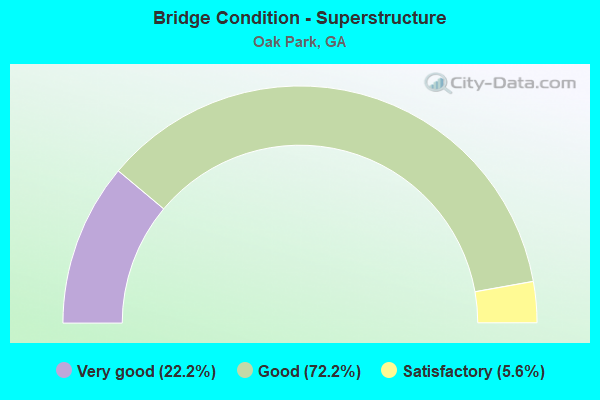
- Bridge Condition - Superstructure
- 22.2%Very good
- 72.2%Good
- 5.6%Satisfactory
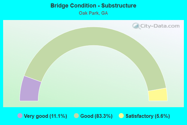
- Bridge Condition - Substructure
- 11.1%Very good
- 83.3%Good
- 5.6%Satisfactory
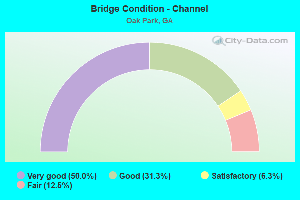
- Bridge Condition - Channel
- 50.0%Very good
- 31.3%Good
- 6.3%Satisfactory
- 12.5%Fair
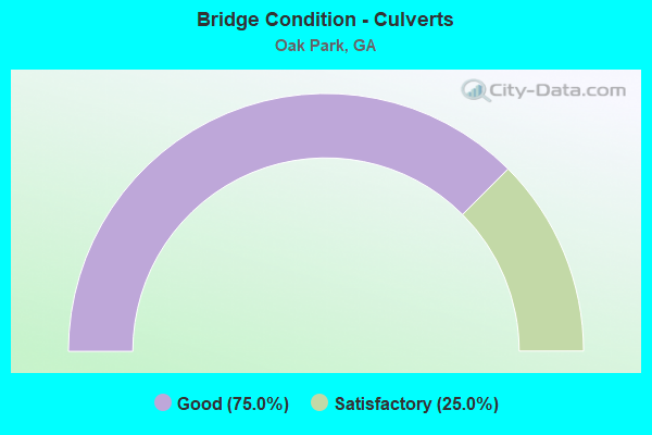
- Bridge Condition - Culverts
- 75.0%Good
- 25.0%Satisfactory
Find on map >> Show street view
Structure Number: 430046, Location: 11.3 MI SW OF METTER (Lat: 32.348589, Lng: -82.247500), Route carried "on" structure: County highway 2926, Year Built: 1979, Status: Open, Structure Length: 15.85m (52.00ft), Average Daily Traffic: 1,040 (year 2011), Truck Traffic: 1%, Average Future Daily Traffic: 1,560 (year 2031), Design Load: HS 15, Features Intersected: OHOOPEE RIVER, Facility Carried by Structure: GRIFFIN FERRY RD
Minimum Vertical Clearance: 30+ m (98+ ft), Kilometerpoint: 0.000, Lanes on structure: 2, Base Highway Network: Yes, Owner: County Highway Agency, Approaching Roadway Width: 6.1m (20.0ft), Material/Design: Concrete, Design/Construction: Tee Beam, Number Of Spans In Main Unit: 13, Length of Maximum Span: 12.2m (40.0ft), Curb-To-Curb Width: 9.2m (30.2ft), Out-to-Out Width: 10.1m (33.1ft)
Condition: Deck: Good, Superstructure: Good, Substructure: Good, Channel: Good, Operating Rating: 39.0 metric tons, Method Used To Determine Operating Rating: Load Factor (LF), Inventory Rating: 23.5 metric tons, Method Used To Determine Inventory Rating: Load Factor (LF), Structural Evaluation: Equal to present minimum criteria, Deck Geometry: Somewhat better than minimum adequacy, Waterway Adequacy: Equal to present desirable criteria, Approach Roadway Alignment: Equal to present desirable criteria, Designated Inspection Frequency: Every 24 months, Inspection Date: November 2020, Bridge Improvement Cost: $2,032,000, Roadway Improvement Cost: $203,000, Total Project Cost: $3,048,000, Deck Structure Type: Concrete Cast-file-Place
Find on map >> Show street view
Structure Number: 1070001, Location: IN OAK PARK (Lat: 32.348369, Lng: -82.313389), Route carried "on" structure: US 1, Year Built: 1926, Year Reconstructed: 1958, Status: Open, Structure Length: 0.98m (3.22ft), Average Daily Traffic: 2,780 (year 2012), Truck Traffic: 1%, Average Future Daily Traffic: 4,170 (year 2032), Design Load: H 15, Features Intersected: READY CREEK
Minimum Vertical Clearance: 30+ m (98+ ft), Kilometerpoint: 6.437, Lanes on structure: 2, Base Highway Network: Yes, Owner: State Highway Agency, Approaching Roadway Width: 8.5m (27.9ft), Material/Design: Concrete, Design/Construction: Culvert, Number Of Spans In Main Unit: 3, Length of Maximum Span: 3.0m (9.8ft)
Condition: Channel: Very good, Culverts: Good, Operating Rating: 65.3 metric tons, Method Used To Determine Operating Rating: Load Factor (LF), Inventory Rating: 39.0 metric tons, Method Used To Determine Inventory Rating: Load Factor (LF), Structural Evaluation: Better than present minimum criteria, Waterway Adequacy: Equal to present desirable criteria, Approach Roadway Alignment: Equal to present desirable criteria, Designated Inspection Frequency: Every 24 months, Inspection Date: August 2021, Bridge Improvement Cost: $125,000, Roadway Improvement Cost: $13,000, Total Project Cost: $188,000
Find on map >> Show street view
Structure Number: 1070025, Location: 3.9 MI NW OF OAK PARK (Lat: 32.385258, Lng: -82.374558), Route carried "on" structure: State highway 46, Year Built: 1939, Status: Open, Structure Length: 0.79m (2.59ft), Average Daily Traffic: 220 (year 2012), Truck Traffic: 22%, Average Future Daily Traffic: 330 (year 2032), Design Load: H 15, Features Intersected: MILL CREEK
Minimum Vertical Clearance: 30+ m (98+ ft), Kilometerpoint: 1.609, Lanes on structure: 2, Base Highway Network: Yes, Owner: State Highway Agency, Approaching Roadway Width: 7.3m (24.0ft), Material/Design: Concrete, Design/Construction: Culvert, Number Of Spans In Main Unit: 4, Length of Maximum Span: 1.8m (5.9ft)
Condition: Channel: Satisfactory, Culverts: Satisfactory, Operating Rating: 42.6 metric tons, Method Used To Determine Operating Rating: Load Factor (LF), Inventory Rating: 25.4 metric tons, Method Used To Determine Inventory Rating: Load Factor (LF), Structural Evaluation: Equal to present minimum criteria, Waterway Adequacy: Equal to present minimum criteria, Approach Roadway Alignment: Equal to present desirable criteria, Designated Inspection Frequency: Every 24 months, Inspection Date: August 2021, Bridge Improvement Cost: $102,000, Roadway Improvement Cost: $10,000, Total Project Cost: $152,000
Find on map >> Show street view
Structure Number: 1070026, Location: 1.9 MI NW OF OAK PARK (Lat: 32.367969, Lng: -82.343489), Route carried "on" structure: State highway 46, Year Built: 1939, Status: Open, Structure Length: 2.74m (8.99ft), Average Daily Traffic: 220 (year 2012), Truck Traffic: 22%, Average Future Daily Traffic: 330 (year 2032), Design Load: H 15, Features Intersected: ABANDONED RAILROAD
Minimum Vertical Clearance: 30+ m (98+ ft), Kilometerpoint: 6.437, Lanes on structure: 2, Base Highway Network: Yes, Owner: State Highway Agency, Approaching Roadway Width: 7.3m (24.0ft), Skew: 1 degrees, Material/Design: Steel, Design/Construction: Stringer/Multi-beam, Number Of Spans In Main Unit: 3, Length of Maximum Span: 9.1m (29.9ft), Curb or Sidewalk Widths: Left: 0.2m (0.7ft), Right: 0.2m (0.7ft), Curb-To-Curb Width: 7.2m (23.6ft), Out-to-Out Width: 8.1m (26.6ft)
Condition: Deck: Good, Superstructure: Good, Substructure: Satisfactory, Operating Rating: 35.3 metric tons, Method Used To Determine Operating Rating: Load Factor (LF), Inventory Rating: 20.8 metric tons, Method Used To Determine Inventory Rating: Load Factor (LF), Structural Evaluation: Equal to present minimum criteria, Deck Geometry: Meets minimum limits, Underclear: Somewhat better than minimum adequacy, Approach Roadway Alignment: Equal to present desirable criteria, Length Of Structure Improvement: 42.98m (141.01ft), Designated Inspection Frequency: Every 24 months, Inspection Date: August 2021, Bridge Improvement Cost: $352,000, Roadway Improvement Cost: $35,000, Total Project Cost: $527,000, Deck Structure Type: Concrete Cast-file-Place
Find on map >> Show street view
Structure Number: 1070053, Location: 3.6 MI W OF STILLMORE (Lat: 32.433850, Lng: -82.276633), Route carried "on" structure: State highway 192, Year Built: 1975, Status: Open, Structure Length: 3.66m (12.01ft), Average Daily Traffic: 400 (year 2012), Truck Traffic: 17%, Average Future Daily Traffic: 600 (year 2032), Design Load: HS 15, Features Intersected: JACKS CREEK
Minimum Vertical Clearance: 30+ m (98+ ft), Kilometerpoint: 1.609, Lanes on structure: 2, Base Highway Network: Yes, Owner: State Highway Agency, Approaching Roadway Width: 6.7m (22.0ft), Material/Design: Concrete, Design/Construction: Tee Beam, Number Of Spans In Main Unit: 3, Length of Maximum Span: 12.2m (40.0ft), Curb-To-Curb Width: 9.7m (31.8ft), Out-to-Out Width: 10.9m (35.8ft)
Condition: Deck: Good, Superstructure: Good, Substructure: Good, Channel: Good, Operating Rating: 42.6 metric tons, Method Used To Determine Operating Rating: Allowable Stress (AS), Inventory Rating: 23.5 metric tons, Method Used To Determine Inventory Rating: Allowable Stress (AS), Structural Evaluation: Equal to present minimum criteria, Deck Geometry: Equal to present minimum criteria, Waterway Adequacy: Equal to present desirable criteria, Approach Roadway Alignment: Equal to present desirable criteria, Designated Inspection Frequency: Every 24 months, Inspection Date: August 2021, Bridge Improvement Cost: $469,000, Roadway Improvement Cost: $47,000, Total Project Cost: $703,000, Deck Structure Type: Concrete Cast-file-Place
Find on map >> Show street view
Structure Number: 1070058, Location: 4.7 MI SW OF STILLMORE (Lat: 32.387850, Lng: -82.267908), Route carried "on" structure: County highway 466, Year Built: 1978, Status: Open, Structure Length: 9.72m (31.89ft), Average Daily Traffic: 490 (year 2012), Truck Traffic: 1%, Average Future Daily Traffic: 735 (year 2032), Design Load: HS 15, Features Intersected: I-16 (SR 404), Facility Carried by Structure: HAWK ROAD
Minimum Vertical Clearance: 30+ m (98+ ft), Kilometerpoint: 0.000, Lanes on structure: 2, Lanes under structure: 4, Base Highway Network: Yes, Owner: State Highway Agency, Approaching Roadway Width: 6.1m (20.0ft), Skew: 1 degrees, Material/Design: Steel continuous, Design/Construction: Stringer/Multi-beam, Number Of Spans In Main Unit: 4, Length of Maximum Span: 32.9m (107.9ft), Curb-To-Curb Width: 8.7m (28.5ft), Out-to-Out Width: 9.8m (32.2ft)
Condition: Deck: Good, Superstructure: Satisfactory, Substructure: Good, Operating Rating: 46.2 metric tons, Method Used To Determine Operating Rating: Load Factor (LF), Inventory Rating: 28.1 metric tons, Method Used To Determine Inventory Rating: Load Factor (LF), Structural Evaluation: Equal to present minimum criteria, Deck Geometry: Somewhat better than minimum adequacy, Underclear: Better than present minimum criteria, Approach Roadway Alignment: Equal to present desirable criteria, Designated Inspection Frequency: Every 24 months, Inspection Date: August 2021, Bridge Improvement Cost: $1,246,000, Roadway Improvement Cost: $125,000, Total Project Cost: $1,870,000, Deck Structure Type: Concrete Cast-file-Place
Find on map >> Show street view
Structure Number: 1070064, Location: 3.3 MI EAST OF SR-297 (EX (Lat: 32.408014, Lng: -82.335600), Route carried "on" structure: Interstate 16, Year Built: 1976, Status: Open, Structure Length: 23.77m (77.99ft), Average Daily Traffic: 16,760 (year 2012), Truck Traffic: 1%, Average Future Daily Traffic: 25,140 (year 2032), Design Load: HS 20+Mod, Features Intersected: OHOOPEE RIVER
Minimum Vertical Clearance: 30+ m (98+ ft), Kilometerpoint: 141.622, Lanes on structure: 2, Base Highway Network: Yes, Owner: State Highway Agency, Approaching Roadway Width: 11.6m (38.1ft), Skew: 10 degrees, Material/Design: Prestressed concrete, Design/Construction: Stringer/Multi-beam, Number Of Spans In Main Unit: 12, Length of Maximum Span: 19.8m (65.0ft), Curb-To-Curb Width: 12.6m (41.3ft), Out-to-Out Width: 13.5m (44.3ft)
Condition: Deck: Good, Superstructure: Good, Substructure: Good, Channel: Fair, Operating Rating: 45.3 metric tons, Method Used To Determine Operating Rating: Load Factor (LF), Inventory Rating: 27.2 metric tons, Method Used To Determine Inventory Rating: Load Factor (LF), Structural Evaluation: Equal to present minimum criteria, Deck Geometry: Better than present minimum criteria, Waterway Adequacy: Equal to present desirable criteria, Approach Roadway Alignment: Equal to present desirable criteria, Designated Inspection Frequency: Every 24 months, Underwater Inspection Frequency: Every 60 months, Inspection Date: August 2021, Underwater Inspection Date: June 2018, Deck Structure Type: Concrete Cast-file-Place
Find on map >> Show street view
Structure Number: 1070065, Location: 3.3 MI E OF SR-297 (EXIT (Lat: 32.408264, Lng: -82.335583), Route carried "on" structure: Interstate 16, Year Built: 1976, Status: Open, Structure Length: 23.77m (77.99ft), Average Daily Traffic: 16,760 (year 2012), Truck Traffic: 1%, Average Future Daily Traffic: 25,140 (year 2032), Design Load: HS 20+Mod, Features Intersected: OHOOPEE RIVER
Minimum Vertical Clearance: 30+ m (98+ ft), Kilometerpoint: 141.622, Lanes on structure: 2, Base Highway Network: Yes, Owner: State Highway Agency, Approaching Roadway Width: 11.6m (38.1ft), Skew: 10 degrees, Material/Design: Prestressed concrete, Design/Construction: Stringer/Multi-beam, Number Of Spans In Main Unit: 12, Length of Maximum Span: 19.8m (65.0ft), Curb-To-Curb Width: 12.6m (41.3ft), Out-to-Out Width: 13.5m (44.3ft)
Condition: Deck: Good, Superstructure: Good, Substructure: Good, Channel: Fair, Operating Rating: 41.7 metric tons, Method Used To Determine Operating Rating: Load Factor (LF), Inventory Rating: 25.4 metric tons, Method Used To Determine Inventory Rating: Load Factor (LF), Structural Evaluation: Equal to present minimum criteria, Deck Geometry: Better than present minimum criteria, Waterway Adequacy: Equal to present desirable criteria, Approach Roadway Alignment: Equal to present desirable criteria, Designated Inspection Frequency: Every 24 months, Underwater Inspection Frequency: Every 60 months, Inspection Date: August 2021, Underwater Inspection Date: June 2018, Deck Structure Type: Concrete Cast-file-Place
Find on map >> Show street view
Structure Number: 1070066, Location: 3.5 MI N OF OAK PARK (Lat: 32.408128, Lng: -82.330183), Route carried "on" structure: Interstate 16, Year Built: 1976, Status: Open, Structure Length: 1.37m (4.49ft), Average Daily Traffic: 16,760 (year 2012), Truck Traffic: 1%, Average Future Daily Traffic: 25,140 (year 2032), Design Load: HS 20+Mod, Features Intersected: YAM GRANDY CREEK
Minimum Vertical Clearance: 30+ m (98+ ft), Kilometerpoint: 141.622, Lanes on structure: 4, Base Highway Network: Yes, Owner: State Highway Agency, Approaching Roadway Width: 23.2m (76.1ft), Skew: 14 degrees, Material/Design: Concrete, Design/Construction: Culvert, Number Of Spans In Main Unit: 3, Length of Maximum Span: 4.3m (14.1ft)
Condition: Channel: Good, Culverts: Good, Operating Rating: 55.3 metric tons, Method Used To Determine Operating Rating: Field evaluation and documented engineering judgment, Inventory Rating: 32.6 metric tons, Method Used To Determine Inventory Rating: Field evaluation and documented engineering judgment, Structural Evaluation: Better than present minimum criteria, Waterway Adequacy: Equal to present desirable criteria, Approach Roadway Alignment: Equal to present desirable criteria, Designated Inspection Frequency: Every 24 months, Inspection Date: August 2021, Bridge Improvement Cost: $272,000, Roadway Improvement Cost: $27,000, Total Project Cost: $408,000
Find on map >> Show street view
Structure Number: 1070067, Location: 3.4 MI NW OF OAK PARK (Lat: 32.408214, Lng: -82.326353), Route carried "on" structure: Interstate 16, Year Built: 1976, Status: Open, Structure Length: 4.66m (15.29ft), Average Daily Traffic: 16,760 (year 2012), Truck Traffic: 1%, Average Future Daily Traffic: 25,140 (year 2032), Design Load: HS 20+Mod, Features Intersected: CSX RAILROAD (ABANDONED)
Minimum Vertical Clearance: 30+ m (98+ ft), Kilometerpoint: 141.622, Lanes on structure: 2, Base Highway Network: Yes, Owner: State Highway Agency, Approaching Roadway Width: 11.6m (38.1ft), Skew: 10 degrees, Material/Design: Prestressed concrete, Design/Construction: Stringer/Multi-beam, Number Of Spans In Main Unit: 3, Length of Maximum Span: 15.5m (50.9ft), Curb-To-Curb Width: 12.8m (42.0ft), Out-to-Out Width: 13.5m (44.3ft)
Condition: Deck: Good, Superstructure: Good, Substructure: Good, Operating Rating: 49.8 metric tons, Method Used To Determine Operating Rating: Load Factor (LF), Inventory Rating: 29.9 metric tons, Method Used To Determine Inventory Rating: Load Factor (LF), Structural Evaluation: Better than present minimum criteria, Deck Geometry: Equal to present desirable criteria, Underclear: Superior to present desirable criteria, Approach Roadway Alignment: Equal to present desirable criteria, Designated Inspection Frequency: Every 24 months, Inspection Date: August 2021, Bridge Improvement Cost: $598,000, Roadway Improvement Cost: $60,000, Total Project Cost: $897,000, Deck Structure Type: Concrete Cast-file-Place
Find on map >> Show street view
Structure Number: 1070068, Location: 3.4 MI NW OF OAK PARK (Lat: 32.408469, Lng: -82.326283), Route carried "on" structure: Interstate 16, Year Built: 1976, Status: Open, Structure Length: 4.66m (15.29ft), Average Daily Traffic: 16,760 (year 2012), Truck Traffic: 1%, Average Future Daily Traffic: 25,140 (year 2032), Design Load: HS 20+Mod, Features Intersected: CSX RAILROAD (ABANDONED)
Minimum Vertical Clearance: 30+ m (98+ ft), Kilometerpoint: 141.622, Lanes on structure: 2, Base Highway Network: Yes, Owner: State Highway Agency, Approaching Roadway Width: 11.6m (38.1ft), Skew: 10 degrees, Material/Design: Prestressed concrete, Design/Construction: Stringer/Multi-beam, Number Of Spans In Main Unit: 3, Length of Maximum Span: 15.5m (50.9ft), Curb-To-Curb Width: 12.8m (42.0ft), Out-to-Out Width: 13.5m (44.3ft)
Condition: Deck: Good, Superstructure: Good, Substructure: Good, Operating Rating: 48.0 metric tons, Method Used To Determine Operating Rating: Load Factor (LF), Inventory Rating: 28.1 metric tons, Method Used To Determine Inventory Rating: Load Factor (LF), Structural Evaluation: Better than present minimum criteria, Deck Geometry: Equal to present desirable criteria, Underclear: Equal to present minimum criteria, Approach Roadway Alignment: Equal to present desirable criteria, Designated Inspection Frequency: Every 24 months, Inspection Date: August 2021, Bridge Improvement Cost: $598,000, Roadway Improvement Cost: $60,000, Total Project Cost: $897,000, Deck Structure Type: Concrete Cast-file-Place
Find on map >> Show street view
Structure Number: 1070069, Location: 2.8 MI N OF OAK PARK (Lat: 32.400819, Lng: -82.307544), Route carried "on" structure: Interstate 16, Year Built: 1976, Status: Open, Structure Length: 6.71m (22.01ft), Average Daily Traffic: 16,760 (year 2012), Truck Traffic: 1%, Average Future Daily Traffic: 25,140 (year 2032), Design Load: HS 20+Mod, Features Intersected: SR 4 (US 1)
Minimum Vertical Clearance: 30+ m (98+ ft), Kilometerpoint: 143.232, Lanes on structure: 2, Lanes under structure: 4, Base Highway Network: Yes, Owner: State Highway Agency, Approaching Roadway Width: 11.6m (38.1ft), Skew: 11 degrees, Material/Design: Steel continuous, Design/Construction: Stringer/Multi-beam, Number Of Spans In Main Unit: 2, Length of Maximum Span: 33.5m (109.9ft), Curb-To-Curb Width: 12.9m (42.3ft), Out-to-Out Width: 13.5m (44.3ft)
Condition: Deck: Good, Superstructure: Good, Substructure: Good, Operating Rating: 40.8 metric tons, Method Used To Determine Operating Rating: Load Factor (LF), Inventory Rating: 24.4 metric tons, Method Used To Determine Inventory Rating: Load Factor (LF), Structural Evaluation: Equal to present minimum criteria, Deck Geometry: Superior to present desirable criteria, Underclear: Superior to present desirable criteria, Approach Roadway Alignment: Equal to present desirable criteria, Designated Inspection Frequency: Every 24 months, Inspection Date: August 2021, Bridge Improvement Cost: $860,000, Roadway Improvement Cost: $86,000, Total Project Cost: $1,289,000, Deck Structure Type: Concrete Cast-file-Place
Find on map >> Show street view
Structure Number: 107007, Location: 3 MI N OF OAK PARK (Lat: 32.401050, Lng: -82.307394), Route carried "on" structure: Interstate 16, Year Built: 1976, Status: Open, Structure Length: 6.71m (22.01ft), Average Daily Traffic: 17,280 (year 2012), Truck Traffic: 1%, Average Future Daily Traffic: 25,920 (year 2032), Design Load: HS 20+Mod, Features Intersected: SR 4 (US 1)
Minimum Vertical Clearance: 30+ m (98+ ft), Kilometerpoint: 143.232, Lanes on structure: 2, Lanes under structure: 4, Base Highway Network: Yes, Owner: State Highway Agency, Approaching Roadway Width: 11.6m (38.1ft), Skew: 11 degrees, Material/Design: Steel continuous, Design/Construction: Stringer/Multi-beam, Number Of Spans In Main Unit: 2, Length of Maximum Span: 33.5m (109.9ft), Curb-To-Curb Width: 12.8m (42.0ft), Out-to-Out Width: 13.5m (44.3ft)
Condition: Deck: Good, Superstructure: Good, Substructure: Good, Operating Rating: 62.5 metric tons, Method Used To Determine Operating Rating: Load Factor (LF), Inventory Rating: 37.1 metric tons, Method Used To Determine Inventory Rating: Load Factor (LF), Structural Evaluation: Better than present minimum criteria, Deck Geometry: Equal to present desirable criteria, Underclear: Better than present minimum criteria, Approach Roadway Alignment: Equal to present desirable criteria, Designated Inspection Frequency: Every 24 months, Inspection Date: August 2021, Bridge Improvement Cost: $860,000, Roadway Improvement Cost: $86,000, Total Project Cost: $1,289,000, Deck Structure Type: Concrete Cast-file-Place
Find on map >> Show street view
Structure Number: 107514, Location: 5.2 MI NE OF SUMMERTOWN (Lat: 32.810800, Lng: -82.236478), Route carried "on" structure: State highway 56, Year Built: 2009, Status: Open, Structure Length: 17.56m (57.61ft), Average Daily Traffic: 1,780 (year 2012), Truck Traffic: 21%, Average Future Daily Traffic: 2,670 (year 2032), Design Load: HS 20+Mod, Features Intersected: OGEECHEE RIVER O/F
Minimum Vertical Clearance: 30+ m (98+ ft), Kilometerpoint: 46.671, Lanes on structure: 2, Base Highway Network: Yes, Owner: State Highway Agency, Approaching Roadway Width: 16.5m (54.1ft), Material/Design: Prestressed concrete, Design/Construction: Stringer/Multi-beam, Number Of Spans In Main Unit: 9, Length of Maximum Span: 19.5m (64.0ft), Curb-To-Curb Width: 13.4m (44.0ft), Out-to-Out Width: 14.5m (47.6ft)
Condition: Deck: Good, Superstructure: Good, Substructure: Good, Channel: Very good, Operating Rating: 69.8 metric tons, Method Used To Determine Operating Rating: Load Factor (LF), Inventory Rating: 32.6 metric tons, Method Used To Determine Inventory Rating: Load Factor (LF), Structural Evaluation: Better than present minimum criteria, Deck Geometry: Equal to present desirable criteria, Waterway Adequacy: Equal to present desirable criteria, Approach Roadway Alignment: Equal to present desirable criteria, Designated Inspection Frequency: Every 24 months, Inspection Date: October 2021, Bridge Improvement Cost: $2,251,000, Roadway Improvement Cost: $225,000, Total Project Cost: $3,376,000, Deck Structure Type: Concrete Cast-file-Place
Find on map >> Show street view
Structure Number: 1075143, Location: 2 MILES NORTH OF OAK PARK (Lat: 32.388750, Lng: -82.316400), Route carried "on" structure: US 1, Year Built: 2013, Status: Open, Structure Length: 8.53m (27.99ft), Average Daily Traffic: 4,500 (year 2013), Truck Traffic: 27%, Average Future Daily Traffic: 6,400 (year 2033), Design Load: HS 20+Mod, Features Intersected: OHOOPEE RIVER O/F
Minimum Vertical Clearance: 30+ m (98+ ft), Kilometerpoint: 12.875, Lanes on structure: 2, Owner: State Highway Agency, Approaching Roadway Width: 12.0m (39.4ft), Material/Design: Prestressed concrete, Design/Construction: Stringer/Multi-beam, Number Of Spans In Main Unit: 5, Length of Maximum Span: 17.1m (56.1ft), Curb-To-Curb Width: 11.0m (36.1ft), Out-to-Out Width: 12.0m (39.4ft)
Condition: Deck: Good, Superstructure: Very good, Substructure: Good, Channel: Very good, Operating Rating: 68.9 metric tons, Method Used To Determine Operating Rating: Load Factor (LF), Inventory Rating: 36.2 metric tons, Method Used To Determine Inventory Rating: Load Factor (LF), Structural Evaluation: Better than present minimum criteria, Deck Geometry: Equal to present minimum criteria, Waterway Adequacy: Equal to present desirable criteria, Approach Roadway Alignment: Equal to present desirable criteria, Length Of Structure Improvement: 401.97m (1318.80ft), Designated Inspection Frequency: Every 24 months, Inspection Date: August 2021, Bridge Improvement Cost: $975,912,000, Roadway Improvement Cost: $97,591,000, Total Project Cost: $146,386,000 ( Estimate for 2014), Deck Structure Type: Concrete Cast-file-Place
Find on map >> Show street view
Structure Number: 1075144, Location: 2.2 MILES NORTH OF OAK PA (Lat: 32.390967, Lng: -82.313900), Route carried "on" structure: US 1, Year Built: 2013, Status: Open, Structure Length: 18.90m (62.01ft), Average Daily Traffic: 4,500 (year 2013), Truck Traffic: 27%, Average Future Daily Traffic: 6,400 (year 2033), Design Load: HS 20+Mod, Features Intersected: OHOOPEE RIVER
Minimum Vertical Clearance: 30+ m (98+ ft), Kilometerpoint: 12.875, Lanes on structure: 2, Owner: State Highway Agency, Approaching Roadway Width: 12.0m (39.4ft), Material/Design: Prestressed concrete, Design/Construction: Stringer/Multi-beam, Number Of Spans In Main Unit: 10, Length of Maximum Span: 21.3m (69.9ft), Curb-To-Curb Width: 11.0m (36.1ft), Out-to-Out Width: 12.0m (39.4ft)
Condition: Deck: Good, Superstructure: Good, Substructure: Good, Channel: Good, Operating Rating: 65.3 metric tons, Method Used To Determine Operating Rating: Load Factor (LF), Inventory Rating: 34.4 metric tons, Method Used To Determine Inventory Rating: Load Factor (LF), Structural Evaluation: Better than present minimum criteria, Deck Geometry: High priority of corrective action, Waterway Adequacy: Equal to present desirable criteria, Approach Roadway Alignment: Equal to present desirable criteria, Length Of Structure Improvement: 22.68m (74.41ft), Designated Inspection Frequency: Every 24 months, Underwater Inspection Frequency: Every 60 months, Inspection Date: August 2021, Underwater Inspection Date: October 2019, Bridge Improvement Cost: $55,056,000, Roadway Improvement Cost: $5,506,000, Total Project Cost: $82,584,000 ( Estimate for 2014), Deck Structure Type: Concrete Cast-file-Place
Find on map >> Show street view
Structure Number: 1075145, Location: 2.5 MILES NORTH OF OAK PA (Lat: 32.392050, Lng: -82.312567), Route carried "on" structure: US 1, Year Built: 2013, Status: Open, Structure Length: 4.94m (16.21ft), Average Daily Traffic: 4,500 (year 2013), Truck Traffic: 27%, Average Future Daily Traffic: 6,400 (year 2033), Design Load: HS 20+Mod, Features Intersected: OHOOPEE RIVER O/F
Minimum Vertical Clearance: 30+ m (98+ ft), Kilometerpoint: 12.875, Lanes on structure: 2, Owner: State Highway Agency, Approaching Roadway Width: 12.0m (39.4ft), Skew: 10 degrees, Material/Design: Prestressed concrete, Design/Construction: Stringer/Multi-beam, Number Of Spans In Main Unit: 3, Length of Maximum Span: 16.5m (54.1ft), Curb-To-Curb Width: 11.0m (36.1ft), Out-to-Out Width: 12.0m (39.4ft)
Condition: Deck: Good, Superstructure: Very good, Substructure: Very good, Channel: Very good, Operating Rating: 68.0 metric tons, Method Used To Determine Operating Rating: Load Factor (LF), Inventory Rating: 35.3 metric tons, Method Used To Determine Inventory Rating: Load Factor (LF), Structural Evaluation: Equal to present desirable criteria, Deck Geometry: High priority of corrective action, Waterway Adequacy: Equal to present minimum criteria, Approach Roadway Alignment: Equal to present desirable criteria, Length Of Structure Improvement: 232.56m (762.99ft), Designated Inspection Frequency: Every 24 months, Inspection Date: August 2021, Bridge Improvement Cost: $564,635,000, Roadway Improvement Cost: $56,464,000, Total Project Cost: $846,953,000 ( Estimate for 2014), Deck Structure Type: Concrete Cast-file-Place
Find on map >> Show street view
Structure Number: 1075146, Location: IN OAK PARK (Lat: 32.348250, Lng: -82.314031), Route carried "on" structure: US 1, Year Built: 2014, Status: Open, Structure Length: 0.91m (2.99ft), Average Daily Traffic: 2,780 (year 2012), Truck Traffic: 1%, Average Future Daily Traffic: 4,170 (year 2032), Design Load: HS 20+Mod, Features Intersected: READY CREEK
Minimum Vertical Clearance: 30+ m (98+ ft), Kilometerpoint: 6.437, Lanes on structure: 4, Base Highway Network: Yes, Owner: State Highway Agency, Approaching Roadway Width: 20.1m (65.9ft), Skew: 4 degrees, Material/Design: Concrete, Design/Construction: Culvert, Number Of Spans In Main Unit: 3, Length of Maximum Span: 2.1m (6.9ft)
Condition: Channel: Very good, Culverts: Good, Structural Evaluation: Better than present minimum criteria, Waterway Adequacy: Equal to present desirable criteria, Approach Roadway Alignment: Equal to present desirable criteria, Length Of Structure Improvement: 1.10m (3.61ft), Designated Inspection Frequency: Every 24 months, Inspection Date: August 2021, Bridge Improvement Cost: $2,664,000, Roadway Improvement Cost: $266,000, Total Project Cost: $3,996,000 ( Estimate for 2015)
Find on map >> Show street view
Structure Number: 1075147, Location: 2 MILES NORTH OF OAK PARK (Lat: 32.388567, Lng: -82.316800), Route carried "on" structure: US 1, Year Built: 2013, Status: Open, Structure Length: 8.53m (27.99ft), Average Daily Traffic: 4,500 (year 2013), Truck Traffic: 27%, Average Future Daily Traffic: 6,400 (year 2033), Design Load: HS 20+Mod, Features Intersected: OHOOPEE RIVER O/F
Minimum Vertical Clearance: 30+ m (98+ ft), Kilometerpoint: 12.875, Lanes on structure: 2, Owner: State Highway Agency, Approaching Roadway Width: 12.0m (39.4ft), Material/Design: Prestressed concrete, Design/Construction: Stringer/Multi-beam, Number Of Spans In Main Unit: 5, Length of Maximum Span: 17.1m (56.1ft), Curb-To-Curb Width: 11.0m (36.1ft), Out-to-Out Width: 12.0m (39.4ft)
Condition: Deck: Good, Superstructure: Very good, Substructure: Good, Channel: Very good, Operating Rating: 69.8 metric tons, Method Used To Determine Operating Rating: Load Factor (LF), Inventory Rating: 39.0 metric tons, Method Used To Determine Inventory Rating: Load Factor (LF), Structural Evaluation: Better than present minimum criteria, Deck Geometry: Equal to present minimum criteria, Waterway Adequacy: Superior to present desirable criteria, Approach Roadway Alignment: Equal to present desirable criteria, Length Of Structure Improvement: 10.24m (33.60ft), Designated Inspection Frequency: Every 24 months, Inspection Date: August 2021, Bridge Improvement Cost: $24,864,000, Roadway Improvement Cost: $2,486,000, Total Project Cost: $37,296,000 ( Estimate for 2016), Deck Structure Type: Concrete Cast-file-Place
Find on map >> Show street view
Structure Number: 1075148, Location: 2.2 MILES NORTH OF OAK PA (Lat: 32.390381, Lng: -82.314667), Route carried "on" structure: US 1, Year Built: 2013, Status: Open, Structure Length: 18.90m (62.01ft), Average Daily Traffic: 4,500 (year 2013), Truck Traffic: 27%, Average Future Daily Traffic: 6,400 (year 2033), Design Load: HS 20+Mod, Features Intersected: OHOOPEE RIVER
Minimum Vertical Clearance: 30+ m (98+ ft), Kilometerpoint: 12.875, Lanes on structure: 2, Owner: State Highway Agency, Approaching Roadway Width: 12.0m (39.4ft), Material/Design: Prestressed concrete, Design/Construction: Stringer/Multi-beam, Number Of Spans In Main Unit: 10, Length of Maximum Span: 21.3m (69.9ft), Curb-To-Curb Width: 11.0m (36.1ft), Out-to-Out Width: 12.0m (39.4ft)
Condition: Deck: Good, Superstructure: Good, Substructure: Good, Channel: Very good, Operating Rating: 61.6 metric tons, Method Used To Determine Operating Rating: Load Factor (LF), Inventory Rating: 35.3 metric tons, Method Used To Determine Inventory Rating: Load Factor (LF), Structural Evaluation: Better than present minimum criteria, Deck Geometry: High priority of corrective action, Waterway Adequacy: Superior to present desirable criteria, Approach Roadway Alignment: Equal to present desirable criteria, Length Of Structure Improvement: 22.68m (74.41ft), Designated Inspection Frequency: Every 24 months, Underwater Inspection Frequency: Every 60 months, Inspection Date: August 2021, Underwater Inspection Date: October 2019, Bridge Improvement Cost: $55,056,000, Roadway Improvement Cost: $5,506,000, Total Project Cost: $82,584,000 ( Estimate for 2016), Deck Structure Type: Concrete Cast-file-Place
Find on map >> Show street view
Structure Number: 1075149, Location: 2.5 MILES NORTH OF OAK PA (Lat: 32.392200, Lng: -82.312681), Route carried "on" structure: US 1, Year Built: 2013, Status: Open, Structure Length: 4.94m (16.21ft), Average Daily Traffic: 4,500 (year 2013), Truck Traffic: 27%, Average Future Daily Traffic: 6,400 (year 2033), Design Load: HS 20+Mod, Features Intersected: OHOOPEE RIVER O/F
Minimum Vertical Clearance: 30+ m (98+ ft), Kilometerpoint: 12.875, Lanes on structure: 2, Owner: State Highway Agency, Approaching Roadway Width: 12.0m (39.4ft), Skew: 10 degrees, Material/Design: Prestressed concrete, Design/Construction: Stringer/Multi-beam, Number Of Spans In Main Unit: 3, Length of Maximum Span: 16.5m (54.1ft), Curb-To-Curb Width: 11.0m (36.1ft), Out-to-Out Width: 12.0m (39.4ft)
Condition: Deck: Good, Superstructure: Very good, Substructure: Very good, Channel: Very good, Operating Rating: 68.9 metric tons, Method Used To Determine Operating Rating: Load Factor (LF), Inventory Rating: 36.2 metric tons, Method Used To Determine Inventory Rating: Load Factor (LF), Structural Evaluation: Equal to present desirable criteria, Deck Geometry: High priority of corrective action, Waterway Adequacy: Superior to present desirable criteria, Approach Roadway Alignment: Equal to present desirable criteria, Length Of Structure Improvement: 5.91m (19.39ft), Designated Inspection Frequency: Every 24 months, Inspection Date: August 2021, Bridge Improvement Cost: $14,356,000, Roadway Improvement Cost: $1,436,000, Total Project Cost: $21,534,000 ( Estimate for 2016), Deck Structure Type: Concrete Cast-file-Place
Find on map >> Show street view
Structure Number: 2795018, Location: 1 MI N OF NORMANTOWN (Lat: 32.327478, Lng: -82.369558), Route carried "on" structure: County highway 226, Year Built: 1968, Year Reconstructed: 2001, Status: Posted for load, Structure Length: 7.32m (24.02ft), Average Daily Traffic: 490 (year 2012), Truck Traffic: 1%, Average Future Daily Traffic: 735 (year 2032), Design Load: H 15, Features Intersected: PENDLETON CREEK, Facility Carried by Structure: NEW NORMANTOWN RD
Minimum Vertical Clearance: 30+ m (98+ ft), Kilometerpoint: 8.047, Lanes on structure: 2, Base Highway Network: Yes, Owner: County Highway Agency, Approaching Roadway Width: 6.1m (20.0ft), Material/Design: Prestressed concrete, Design/Construction: Channel Beam, Number Of Spans In Main Unit: 12, Length of Maximum Span: 6.1m (20.0ft), Curb-To-Curb Width: 6.9m (22.6ft), Out-to-Out Width: 7.7m (25.3ft)
Condition: Deck: Good, Superstructure: Good, Substructure: Good, Channel: Good, Operating Rating: 45.3 metric tons, Method Used To Determine Operating Rating: Load Factor (LF), Inventory Rating: 27.2 metric tons, Method Used To Determine Inventory Rating: Load Factor (LF), Structural Evaluation: Equal to present minimum criteria, Deck Geometry: Meets minimum limits, Waterway Adequacy: Better than present minimum criteria, Approach Roadway Alignment: Equal to present desirable criteria, Designated Inspection Frequency: Every 24 months, Underwater Inspection Frequency: Every 60 months, Inspection Date: June 2021, Underwater Inspection Date: September 2021, Bridge Improvement Cost: $938,000, Roadway Improvement Cost: $94,000, Total Project Cost: $1,407,000, Deck Structure Type: Concrete Precast Panels
Find on map >> Show street view
Structure Number: 1070058, Location: 4.7 MI SW OF STILLMORE (Lat: 32.387850, Lng: -82.267908), Route carried "under" structure: Interstate 16, Structure Length: 0. m, Average Daily Traffic: 11,800 (year 2010), Truck Traffic: 1%, Features Intersected: CR 466 LAND SERVICE FAC., Facility Carried by Structure: HAWK ROAD
Minimum Vertical Clearance: 5.20m (17.06ft), Kilometerpoint: 148.060, Lanes on structure: 2, Length of Maximum Span: 0.0m
Find on map >> Show street view
Structure Number: 1070069, Location: 2.8 MI N OF OAK PARK (Lat: 32.400819, Lng: -82.307544), Route carried "under" structure: US 1, Structure Length: 0. m, Average Daily Traffic: 4,300 (year 2010), Truck Traffic: 1%, Features Intersected: I-16 EBL (SR 404)
Minimum Vertical Clearance: 5.61m (18.41ft), Kilometerpoint: 14.484, Lanes on structure: 2, Length of Maximum Span: 0.0m
Find on map >> Show street view
Structure Number: 107007, Location: 3 MI N OF OAK PARK (Lat: 32.401050, Lng: -82.307394), Route carried "under" structure: US 1, Structure Length: 0. m, Average Daily Traffic: 4,300 (year 2010), Truck Traffic: 1%, Features Intersected: I-16 WBL (SR 404)
Minimum Vertical Clearance: 5.20m (17.06ft), Kilometerpoint: 14.484, Lanes on structure: 2, Length of Maximum Span: 0.0m