Bridge Statistics for Oakland, California (CA)
Condition, Traffic, Stress, Structural Evaluation, Project Costs
- National Bridge Inventory (NBI) Statistics
- 538Number of bridges
- 12,913ft / 3,936mTotal length
- $103,067,000Total costs
- 27,471,529Total average daily traffic
- 982,540Total average daily truck traffic
- National Bridge Inventory (NBI) Registered Bridges for Oakland
- No street view available for this location
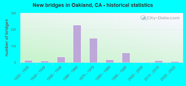
- New bridges - historical statistics
- 11900-1909
- 11910-1919
- 21920-1929
- 141930-1939
- 101940-1949
- 351950-1959
- 2281960-1969
- 1491970-1979
- 181980-1989
- 601990-1999
- 12000-2009
- 122010-2019
- 72020-2022
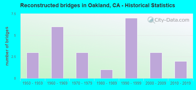
- Reconstructed bridges - Historical Statistics
- 31950-1959
- 61960-1969
- 31970-1979
- 11980-1989
- 71990-1999
- 32000-2009
- 22010-2019
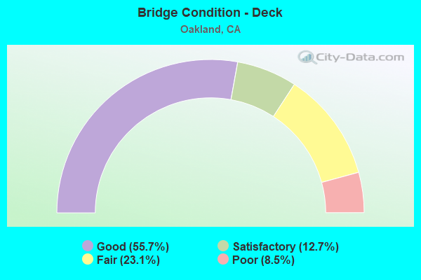
- Bridge Condition - Deck
- 55.7%Good
- 12.7%Satisfactory
- 23.1%Fair
- 8.5%Poor
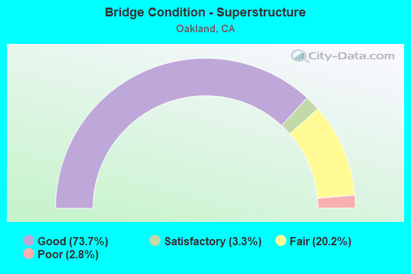
- Bridge Condition - Superstructure
- 73.7%Good
- 3.3%Satisfactory
- 20.2%Fair
- 2.8%Poor
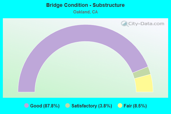
- Bridge Condition - Substructure
- 87.8%Good
- 3.8%Satisfactory
- 8.5%Fair
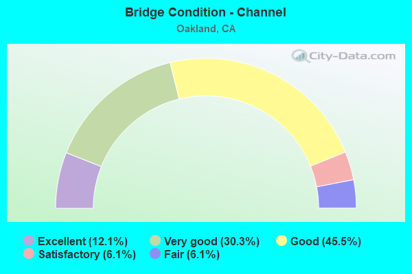
- Bridge Condition - Channel
- 12.1%Excellent
- 30.3%Very good
- 45.5%Good
- 6.1%Satisfactory
- 6.1%Fair
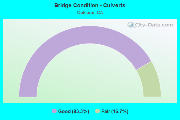
- Bridge Condition - Culverts
- 83.3%Good
- 16.7%Fair
Find on map >> Show street view
Structure Number: 33 0365R, Location: 04-ALA-024-R2.59-OAK (Lat: 37.834494, Lng: -122.265572), Route carried "on" structure: State highway 24, Year Built: 1970, Status: Open, Structure Length: 4.24m (13.91ft), Average Daily Traffic: 75,500 (year 2012), Truck Traffic: 3%, Average Future Daily Traffic: 97,226 (year 2044), Design Load: HS 20+Mod, Features Intersected: E24-ML KING JR OFF RAMP
Minimum Vertical Clearance: 30+ m (98+ ft), Kilometerpoint: 2.590, Lanes on structure: 4, Lanes under structure: 1, Base Highway Network: Yes (, Subroute: 1), Owner: State Highway Agency, Approaching Roadway Width: 19.5m (64.0ft), Skew: 9 degrees, Material/Design: Concrete continuous, Design/Construction: Box Beam or Girders - Multiple, Number Of Spans In Main Unit: 3, Length of Maximum Span: 18.9m (62.0ft), Curb-To-Curb Width: 20.4m (66.9ft), Out-to-Out Width: 21.0m (68.9ft)
Condition: Deck: Good, Superstructure: Fair, Substructure: Good, Operating Rating: 82.3 metric tons, Method Used To Determine Operating Rating: Load Factor (LF), Inventory Rating: 49.2 metric tons, Method Used To Determine Inventory Rating: Load Factor (LF), Structural Evaluation: Somewhat better than minimum adequacy, Deck Geometry: Equal to present minimum criteria, Underclear: High priority of corrective action, Approach Roadway Alignment: Equal to present desirable criteria, Designated Inspection Frequency: Every 24 months, Inspection Date: January 2022, Deck Structure Type: Concrete Cast-file-Place
Find on map >> Show street view
Structure Number: 33 037, Location: 04-ALA-092-R5.12-HAY (Lat: 37.631928, Lng: -122.110211), Route carried "on" structure: State highway 92, Year Built: 1966, Year Reconstructed: 2001, Status: Open, Structure Length: 5.18m (16.99ft), Average Daily Traffic: 92,000 (year 2009), Average Future Daily Traffic: 143,493 (year 2043), Design Load: HS 20, Features Intersected: INDUSTRIAL BLVD
Minimum Vertical Clearance: 30+ m (98+ ft), Kilometerpoint: 5.120, Lanes on structure: 10, Lanes under structure: 5, Base Highway Network: Yes (, Subroute: 1), Owner: State Highway Agency, Approaching Roadway Width: 48.5m (159.1ft), Skew: 30 degrees, Material/Design: Prestressed concrete, Design/Construction: Stringer/Multi-beam, Number Of Spans In Main Unit: 3, Length of Maximum Span: 29.0m (95.1ft), Curb-To-Curb Width: 48.5m (159.1ft), Out-to-Out Width: 50.1m (164.4ft)
Condition: Deck: Fair, Superstructure: Good, Substructure: Good, Operating Rating: 20.7 metric tons, Method Used To Determine Operating Rating: Load and Resistance Factor Rating (LRFR) rating reported by rating factor(RF) method using HL-93 loadings, Inventory Rating: 15.9 metric tons, Method Used To Determine Inventory Rating: Load and Resistance Factor Rating (LRFR) rating reported by rating factor(RF) method using HL-93 loadings, Structural Evaluation: High priority of corrective action, Deck Geometry: Superior to present desirable criteria, Underclear: Meets minimum limits, Approach Roadway Alignment: Better than present minimum criteria, Designated Inspection Frequency: Every 24 months, Inspection Date: September 2021, Deck Structure Type: Concrete Cast-file-Place
Find on map >> Show street view
Structure Number: 33 0376, Location: 04-ALA-013-R9.58-OAK (Lat: 37.848269, Lng: -122.228458), Route carried "on" structure: City street , Year Built: 1998, Status: Open, Structure Length: 9.52m (31.23ft), Average Daily Traffic: 5,000 (year 2009), Truck Traffic: 3%, Average Future Daily Traffic: 7,456 (year 2043), Design Load: HS 20+Mod, Features Intersected: STATE ROUTE 13, Facility Carried by Structure: BROADWAY
Minimum Vertical Clearance: 30+ m (98+ ft), Kilometerpoint: 0.000, Lanes on structure: 2, Lanes under structure: 6, Owner: State Highway Agency, Approaching Roadway Width: 12.6m (41.3ft), Skew: 3 degrees, Material/Design: Prestressed concrete continuous, Design/Construction: Box Beam or Girders - Multiple, Number Of Spans In Main Unit: 2, Length of Maximum Span: 56.0m (183.7ft), Curb or Sidewalk Widths: Left: 0.0m, Right: 1.5m (4.9ft), Curb-To-Curb Width: 10.3m (33.8ft), Out-to-Out Width: 12.4m (40.7ft)
Condition: Deck: Fair, Superstructure: Good, Substructure: Good, Operating Rating: 54.1 metric tons, Method Used To Determine Operating Rating: Assigned rating based on Load Factor Design (LFD) reported in metric tons, Inventory Rating: 32.4 metric tons, Method Used To Determine Inventory Rating: Assigned rating based on Load Factor Design (LFD) reported in metric tons, Structural Evaluation: Better than present minimum criteria, Deck Geometry: Meets minimum limits, Underclear: Meets minimum limits, Approach Roadway Alignment: Equal to present desirable criteria, Designated Inspection Frequency: Every 24 months, Inspection Date: March 2021, Deck Structure Type: Concrete Cast-file-Place
Find on map >> Show street view
Structure Number: 33 0377G, Location: 04-ALA-013-R9.57-OAK (Lat: 37.847850, Lng: -122.226942), Route carried "on" structure: Ramp State highway 13, Year Built: 1970, Status: Open, Structure Length: 7.35m (24.11ft), Average Daily Traffic: 40,000 (year 2009), Truck Traffic: 1%, Average Future Daily Traffic: 59,655 (year 2043), Design Load: HS 20+Mod, Features Intersected: BROADWAY
Minimum Vertical Clearance: 30+ m (98+ ft), Kilometerpoint: 9.570, Lanes on structure: 1, Lanes under structure: 2, Base Highway Network: Yes (, Subroute: 1), Owner: State Highway Agency, Approaching Roadway Width: 7.6m (24.9ft), Material/Design: Concrete continuous, Design/Construction: Box Beam or Girders - Multiple, Number Of Spans In Main Unit: 3, Length of Maximum Span: 32.9m (107.9ft), Curb-To-Curb Width: 7.9m (25.9ft), Out-to-Out Width: 8.5m (27.9ft)
Condition: Deck: Satisfactory, Superstructure: Satisfactory, Substructure: Satisfactory, Operating Rating: 36.3 metric tons, Method Used To Determine Operating Rating: Load and Resistance Factor Rating (LRFR) rating reported by rating factor(RF) method using HL-93 loadings, Inventory Rating: 28.2 metric tons, Method Used To Determine Inventory Rating: Load and Resistance Factor Rating (LRFR) rating reported by rating factor(RF) method using HL-93 loadings, Structural Evaluation: Equal to present minimum criteria, Deck Geometry: Equal to present desirable criteria, Underclear: Equal to present minimum criteria, Approach Roadway Alignment: Somewhat better than minimum adequacy, Designated Inspection Frequency: Every 24 months, Inspection Date: March 2021, Deck Structure Type: Concrete Cast-file-Place
Find on map >> Show street view
Structure Number: 33 0378, Location: 04-ALA-024-R5.08-OAK (Lat: 37.848633, Lng: -122.228661), Route carried "on" structure: State highway 24, Year Built: 1970, Status: Open, Structure Length: 8.73m (28.64ft), Average Daily Traffic: 147,000 (year 2010), Truck Traffic: 3%, Average Future Daily Traffic: 200,363 (year 2044), Design Load: HS 20+Mod, Features Intersected: STATE ROUTE 13
Minimum Vertical Clearance: 30+ m (98+ ft), Kilometerpoint: 5.080, Lanes on structure: 8, Lanes under structure: 5, Base Highway Network: Yes (, Subroute: 1), Owner: State Highway Agency, Approaching Roadway Width: 40.8m (133.9ft), Skew: 25 degrees, Material/Design: Prestressed concrete continuous, Design/Construction: Box Beam or Girders - Multiple, Number Of Spans In Main Unit: 2, Length of Maximum Span: 42.7m (140.1ft), Curb-To-Curb Width: 41.3m (135.5ft), Out-to-Out Width: 41.3m (135.5ft)
Condition: Deck: Good, Superstructure: Satisfactory, Substructure: Good, Operating Rating: 76.5 metric tons, Method Used To Determine Operating Rating: Load Factor (LF), Inventory Rating: 32.4 metric tons, Method Used To Determine Inventory Rating: Load Factor (LF), Structural Evaluation: Equal to present minimum criteria, Deck Geometry: Superior to present desirable criteria, Underclear: Somewhat better than minimum adequacy, Approach Roadway Alignment: Equal to present desirable criteria, Designated Inspection Frequency: Every 24 months, Inspection Date: Febuary 2022, Deck Structure Type: Concrete Cast-file-Place
Find on map >> Show street view
Structure Number: 33 0392L, Location: 04-ALA-024-R2.50-OAK (Lat: 37.833600, Lng: -122.265708), Route carried "on" structure: State highway 24, Year Built: 1969, Status: Open, Structure Length: 1.02m (3.35ft), Average Daily Traffic: 75,500 (year 2009), Truck Traffic: 3%, Average Future Daily Traffic: 96,903 (year 2040), Features Intersected: BARTD
Minimum Vertical Clearance: 30+ m (98+ ft), Kilometerpoint: 2.500, Lanes on structure: 6, Base Highway Network: Yes (, Subroute: 1), Owner: State Highway Agency, Approaching Roadway Width: 34.7m (113.8ft), Skew: 29 degrees, Material/Design: Concrete, Design/Construction: Frame, Number Of Spans In Main Unit: 2, Length of Maximum Span: 5.4m (17.7ft), Curb-To-Curb Width: 30.8m (101.0ft), Out-to-Out Width: 35.4m (116.1ft)
Condition: Deck: Good, Superstructure: Good, Substructure: Good, Operating Rating: 54.1 metric tons, Method Used To Determine Operating Rating: Field evaluation and documented engineering judgment, Inventory Rating: 32.4 metric tons, Method Used To Determine Inventory Rating: Field evaluation and documented engineering judgment, Structural Evaluation: Better than present minimum criteria, Deck Geometry: Superior to present desirable criteria, Underclear: High priority of corrective action, Approach Roadway Alignment: Equal to present desirable criteria, Designated Inspection Frequency: Every 48 months, Inspection Date: January 2022
Find on map >> Show street view
Structure Number: 33 0411L, Location: 04-ALA-024-R2.90-OAK (Lat: 37.839236, Lng: -122.264719), Route carried "on" structure: State highway 24, Year Built: 1970, Status: Open, Structure Length: 7.68m (25.20ft), Average Daily Traffic: 75,500 (year 2012), Truck Traffic: 3%, Average Future Daily Traffic: 99,517 (year 2044), Design Load: HS 20, Features Intersected: SHATTUCK AVE
Minimum Vertical Clearance: 30+ m (98+ ft), Kilometerpoint: 2.900, Lanes on structure: 4, Lanes under structure: 4, Base Highway Network: Yes (, Subroute: 1), Owner: State Highway Agency, Approaching Roadway Width: 19.5m (64.0ft), Skew: 4 degrees, Material/Design: Concrete continuous, Design/Construction: Box Beam or Girders - Multiple, Number Of Spans In Main Unit: 4, Length of Maximum Span: 38.1m (125.0ft), Curb-To-Curb Width: 20.4m (66.9ft), Out-to-Out Width: 21.0m (68.9ft)
Condition: Deck: Good, Superstructure: Good, Substructure: Good, Operating Rating: 89.1 metric tons, Method Used To Determine Operating Rating: Load Factor (LF), Inventory Rating: 53.5 metric tons, Method Used To Determine Inventory Rating: Load Factor (LF), Structural Evaluation: Better than present minimum criteria, Deck Geometry: Equal to present minimum criteria, Underclear: Somewhat better than minimum adequacy, Approach Roadway Alignment: Equal to present desirable criteria, Designated Inspection Frequency: Every 24 months, Inspection Date: January 2022, Deck Structure Type: Concrete Cast-file-Place
Find on map >> Show street view
Structure Number: 33 0411R, Location: 04-ALA-024-R2.90-OAK (Lat: 37.838875, Lng: -122.264525), Route carried "on" structure: State highway 24, Year Built: 1970, Status: Open, Structure Length: 6.83m (22.41ft), Average Daily Traffic: 75,500 (year 2012), Truck Traffic: 3%, Average Future Daily Traffic: 99,517 (year 2044), Design Load: HS 20, Features Intersected: SHATTUCK AVE
Minimum Vertical Clearance: 30+ m (98+ ft), Kilometerpoint: 2.900, Lanes on structure: 4, Lanes under structure: 2, Base Highway Network: Yes (, Subroute: 1), Owner: State Highway Agency, Approaching Roadway Width: 19.5m (64.0ft), Skew: 4 degrees, Material/Design: Concrete continuous, Design/Construction: Box Beam or Girders - Multiple, Number Of Spans In Main Unit: 3, Length of Maximum Span: 32.3m (106.0ft), Curb-To-Curb Width: 20.4m (66.9ft), Out-to-Out Width: 21.0m (68.9ft)
Condition: Deck: Good, Superstructure: Good, Substructure: Good, Operating Rating: 52.8 metric tons, Method Used To Determine Operating Rating: Load and Resistance Factor Rating (LRFR) rating reported by rating factor(RF) method using HL-93 loadings, Inventory Rating: 40.8 metric tons, Method Used To Determine Inventory Rating: Load and Resistance Factor Rating (LRFR) rating reported by rating factor(RF) method using HL-93 loadings, Structural Evaluation: Better than present minimum criteria, Deck Geometry: Equal to present minimum criteria, Underclear: Meets minimum limits, Approach Roadway Alignment: Equal to present desirable criteria, Designated Inspection Frequency: Every 24 months, Inspection Date: January 2022, Deck Structure Type: Concrete Cast-file-Place
Find on map >> Show street view
Structure Number: 33 0412L, Location: 04-ALA-024-R2.99-OAK (Lat: 37.840217, Lng: -122.263742), Route carried "on" structure: State highway 24, Year Built: 1970, Status: Open, Structure Length: 5.76m (18.90ft), Average Daily Traffic: 75,500 (year 2009), Truck Traffic: 3%, Average Future Daily Traffic: 94,672 (year 2040), Design Load: HS 20, Features Intersected: 55TH STREET
Minimum Vertical Clearance: 30+ m (98+ ft), Kilometerpoint: 2.990, Lanes on structure: 4, Lanes under structure: 2, Base Highway Network: Yes (, Subroute: 1), Owner: State Highway Agency, Approaching Roadway Width: 19.5m (64.0ft), Skew: 5 degrees, Material/Design: Concrete continuous, Design/Construction: Box Beam or Girders - Multiple, Number Of Spans In Main Unit: 3, Length of Maximum Span: 25.0m (82.0ft), Curb-To-Curb Width: 20.4m (66.9ft), Out-to-Out Width: 21.0m (68.9ft)
Condition: Deck: Good, Superstructure: Good, Substructure: Good, Operating Rating: 41.5 metric tons, Method Used To Determine Operating Rating: Load and Resistance Factor Rating (LRFR) rating reported by rating factor(RF) method using HL-93 loadings, Inventory Rating: 32.1 metric tons, Method Used To Determine Inventory Rating: Load and Resistance Factor Rating (LRFR) rating reported by rating factor(RF) method using HL-93 loadings, Structural Evaluation: Better than present minimum criteria, Deck Geometry: Equal to present minimum criteria, Underclear: Better than present minimum criteria, Approach Roadway Alignment: Equal to present desirable criteria, Designated Inspection Frequency: Every 48 months, Inspection Date: Febuary 2022, Deck Structure Type: Concrete Cast-file-Place
Find on map >> Show street view
Structure Number: 33 0412R, Location: 04-ALA-024-R2.99-OAK (Lat: 37.840158, Lng: -122.263211), Route carried "on" structure: State highway 24, Year Built: 1970, Status: Open, Structure Length: 6.07m (19.91ft), Average Daily Traffic: 75,500 (year 2009), Truck Traffic: 3%, Average Future Daily Traffic: 94,672 (year 2040), Design Load: HS 20, Features Intersected: 55TH STREET
Minimum Vertical Clearance: 30+ m (98+ ft), Kilometerpoint: 2.990, Lanes on structure: 5, Lanes under structure: 2, Base Highway Network: Yes (, Subroute: 1), Owner: State Highway Agency, Approaching Roadway Width: 21.6m (70.9ft), Skew: 4 degrees, Material/Design: Concrete continuous, Design/Construction: Box Beam or Girders - Multiple, Number Of Spans In Main Unit: 3, Length of Maximum Span: 25.9m (85.0ft), Curb-To-Curb Width: 22.9m (75.1ft), Out-to-Out Width: 23.5m (77.1ft)
Condition: Deck: Good, Superstructure: Good, Substructure: Good, Operating Rating: 66.4 metric tons, Method Used To Determine Operating Rating: Load Factor (LF), Inventory Rating: 39.9 metric tons, Method Used To Determine Inventory Rating: Load Factor (LF), Structural Evaluation: Better than present minimum criteria, Deck Geometry: Somewhat better than minimum adequacy, Underclear: Better than present minimum criteria, Approach Roadway Alignment: Equal to present desirable criteria, Designated Inspection Frequency: Every 48 months, Inspection Date: Febuary 2022, Deck Structure Type: Concrete Cast-file-Place
Find on map >> Show street view
Structure Number: 33 0413L, Location: 04-ALA-024-R3.06-OAK (Lat: 37.840908, Lng: -122.262622), Route carried "on" structure: State highway 24, Year Built: 1970, Status: Open, Structure Length: 11.73m (38.48ft), Average Daily Traffic: 153,000 (year 2012), Truck Traffic: 2%, Average Future Daily Traffic: 280,954 (year 2040), Design Load: HS 20, Features Intersected: TELEGRAPH AVE
Minimum Vertical Clearance: 30+ m (98+ ft), Kilometerpoint: 3.060, Lanes on structure: 4, Lanes under structure: 7, Base Highway Network: Yes (, Subroute: 1), Owner: State Highway Agency, Approaching Roadway Width: 23.5m (77.1ft), Skew: 9 degrees, Material/Design: Concrete continuous, Design/Construction: Box Beam or Girders - Multiple, Number Of Spans In Main Unit: 5, Length of Maximum Span: 36.7m (120.4ft), Curb-To-Curb Width: 20.4m (66.9ft), Out-to-Out Width: 21.0m (68.9ft)
Condition: Deck: Good, Superstructure: Good, Substructure: Good, Operating Rating: 87.8 metric tons, Method Used To Determine Operating Rating: Load Factor (LF), Inventory Rating: 52.5 metric tons, Method Used To Determine Inventory Rating: Load Factor (LF), Structural Evaluation: Better than present minimum criteria, Deck Geometry: Equal to present minimum criteria, Underclear: Equal to present minimum criteria, Approach Roadway Alignment: Equal to present desirable criteria, Designated Inspection Frequency: Every 24 months, Inspection Date: Febuary 2022, Deck Structure Type: Concrete Cast-file-Place
Find on map >> Show street view
Structure Number: 33 0413R, Location: 04-ALA-024-R3.06-OAK (Lat: 37.840706, Lng: -122.262286), Route carried "on" structure: State highway 24, Year Built: 1970, Status: Open, Structure Length: 9.60m (31.50ft), Average Daily Traffic: 147,500 (year 2010), Truck Traffic: 2%, Average Future Daily Traffic: 270,344 (year 2040), Design Load: HS 20, Features Intersected: TELEGRAPH AVE
Minimum Vertical Clearance: 30+ m (98+ ft), Kilometerpoint: 3.060, Lanes on structure: 4, Lanes under structure: 7, Base Highway Network: Yes (, Subroute: 1), Owner: State Highway Agency, Approaching Roadway Width: 22.6m (74.1ft), Material/Design: Prestressed concrete continuous, Design/Construction: Box Beam or Girders - Multiple, Number Of Spans In Main Unit: 3, Length of Maximum Span: 54.3m (178.1ft), Curb-To-Curb Width: 20.4m (66.9ft), Out-to-Out Width: 21.0m (68.9ft)
Condition: Deck: Good, Superstructure: Good, Substructure: Good, Operating Rating: 53.1 metric tons, Method Used To Determine Operating Rating: Load and Resistance Factor Rating (LRFR) rating reported by rating factor(RF) method using HL-93 loadings, Inventory Rating: 32.1 metric tons, Method Used To Determine Inventory Rating: Load and Resistance Factor Rating (LRFR) rating reported by rating factor(RF) method using HL-93 loadings, Structural Evaluation: Better than present minimum criteria, Deck Geometry: Equal to present minimum criteria, Underclear: Somewhat better than minimum adequacy, Approach Roadway Alignment: Equal to present desirable criteria, Designated Inspection Frequency: Every 24 months, Inspection Date: Febuary 2022, Deck Structure Type: Concrete Cast-file-Place
Find on map >> Show street view
Structure Number: 33 0413S, Location: 04-ALA-024-R3.06-OAK (Lat: 37.840617, Lng: -122.262244), Route carried "on" structure: Bypass State highway 24, Year Built: 1970, Status: Open, Structure Length: 7.25m (23.79ft), Average Daily Traffic: 11,760 (year 2010), Truck Traffic: 2%, Average Future Daily Traffic: 21,595 (year 2040), Design Load: HS 20, Features Intersected: TELEGRAPH AVE
Minimum Vertical Clearance: 30+ m (98+ ft), Kilometerpoint: 3.060, Lanes on structure: 2, Lanes under structure: 4, Base Highway Network: Yes (, Subroute: 1), Owner: State Highway Agency, Approaching Roadway Width: 9.4m (30.8ft), Skew: 9 degrees, Material/Design: Prestressed concrete continuous, Design/Construction: Box Beam or Girders - Multiple, Number Of Spans In Main Unit: 2, Number Of Approach Spans: 1, Length of Maximum Span: 36.3m (119.1ft), Curb-To-Curb Width: 7.3m (24.0ft), Out-to-Out Width: 7.9m (25.9ft)
Condition: Deck: Good, Superstructure: Good, Substructure: Good, Operating Rating: 58.6 metric tons, Method Used To Determine Operating Rating: Load and Resistance Factor Rating (LRFR) rating reported by rating factor(RF) method using HL-93 loadings, Inventory Rating: 36.6 metric tons, Method Used To Determine Inventory Rating: Load and Resistance Factor Rating (LRFR) rating reported by rating factor(RF) method using HL-93 loadings, Structural Evaluation: Better than present minimum criteria, Deck Geometry: High priority of replacement, Underclear: Equal to present minimum criteria, Approach Roadway Alignment: Equal to present desirable criteria, Designated Inspection Frequency: Every 24 months, Inspection Date: Febuary 2022, Deck Structure Type: Concrete Cast-file-Place
Find on map >> Show street view
Structure Number: 33 0414K, Location: 04-ALA-024-R3.38-OAK (Lat: 37.842994, Lng: -122.257689), Route carried "on" structure: Bypass State highway 24, Year Built: 1970, Status: Open, Structure Length: 5.49m (18.01ft), Average Daily Traffic: 5,609 (year 2010), Truck Traffic: 2%, Average Future Daily Traffic: 10,300 (year 2040), Design Load: HS 20, Features Intersected: CLAREMONT AVE
Minimum Vertical Clearance: 30+ m (98+ ft), Kilometerpoint: 3.380, Lanes on structure: 1, Lanes under structure: 5, Base Highway Network: Yes (, Subroute: 1), Owner: State Highway Agency, Approaching Roadway Width: 7.3m (24.0ft), Skew: 2 degrees, Material/Design: Concrete continuous, Design/Construction: Box Beam or Girders - Multiple, Number Of Spans In Main Unit: 2, Length of Maximum Span: 27.4m (89.9ft), Curb-To-Curb Width: 7.3m (24.0ft), Out-to-Out Width: 7.9m (25.9ft)
Condition: Deck: Good, Superstructure: Good, Substructure: Good, Operating Rating: 79.4 metric tons, Method Used To Determine Operating Rating: Load Factor (LF), Inventory Rating: 47.6 metric tons, Method Used To Determine Inventory Rating: Load Factor (LF), Structural Evaluation: Better than present minimum criteria, Deck Geometry: High priority of replacement, Underclear: Somewhat better than minimum adequacy, Approach Roadway Alignment: Equal to present desirable criteria, Designated Inspection Frequency: Every 48 months, Inspection Date: Febuary 2022, Deck Structure Type: Concrete Cast-file-Place
Find on map >> Show street view
Structure Number: 33 0414L, Location: 04-ALA-024-R3.32-OAK (Lat: 37.842375, Lng: -122.258269), Route carried "on" structure: State highway 24, Year Built: 1970, Status: Open, Structure Length: 15.58m (51.12ft), Average Daily Traffic: 143,000 (year 2010), Truck Traffic: 2%, Average Future Daily Traffic: 262,591 (year 2040), Design Load: HS 20, Features Intersected: CLAREMONT AVE
Minimum Vertical Clearance: 30+ m (98+ ft), Kilometerpoint: 3.320, Lanes on structure: 4, Lanes under structure: 7, Base Highway Network: Yes (, Subroute: 1), Owner: State Highway Agency, Approaching Roadway Width: 19.5m (64.0ft), Skew: 5 degrees, Material/Design: Concrete continuous, Design/Construction: Box Beam or Girders - Multiple, Number Of Spans In Main Unit: 6, Length of Maximum Span: 36.3m (119.1ft), Curb-To-Curb Width: 20.4m (66.9ft), Out-to-Out Width: 21.0m (68.9ft)
Condition: Deck: Good, Superstructure: Good, Substructure: Good, Channel: Excellent, Operating Rating: 73.9 metric tons, Method Used To Determine Operating Rating: Load Factor (LF), Inventory Rating: 44.4 metric tons, Method Used To Determine Inventory Rating: Load Factor (LF), Structural Evaluation: Better than present minimum criteria, Deck Geometry: Equal to present minimum criteria, Underclear: Somewhat better than minimum adequacy, Waterway Adequacy: Superior to present desirable criteria, Approach Roadway Alignment: Equal to present desirable criteria, Designated Inspection Frequency: Every 24 months, Inspection Date: Febuary 2022, Deck Structure Type: Concrete Cast-file-Place
Find on map >> Show street view
Structure Number: 33 0414R, Location: 04-ALA-024-R3.30-OAK (Lat: 37.841919, Lng: -122.258525), Route carried "on" structure: State highway 24, Year Built: 1970, Status: Open, Structure Length: 18.47m (60.60ft), Average Daily Traffic: 143,000 (year 2012), Truck Traffic: 2%, Average Future Daily Traffic: 262,591 (year 2040), Design Load: HS 20+Mod, Features Intersected: CLAREMONT AVE
Minimum Vertical Clearance: 30+ m (98+ ft), Kilometerpoint: 3.300, Lanes on structure: 4, Lanes under structure: 6, Base Highway Network: Yes (, Subroute: 1), Owner: State Highway Agency, Approaching Roadway Width: 24.1m (79.1ft), Skew: 5 degrees, Material/Design: Concrete continuous, Design/Construction: Box Beam or Girders - Multiple, Number Of Spans In Main Unit: 8, Length of Maximum Span: 39.0m (128.0ft), Curb-To-Curb Width: 24.1m (79.1ft), Out-to-Out Width: 24.7m (81.0ft)
Condition: Deck: Good, Superstructure: Good, Substructure: Good, Channel: Excellent, Operating Rating: 49.6 metric tons, Method Used To Determine Operating Rating: Load Factor (LF), Inventory Rating: 29.8 metric tons, Method Used To Determine Inventory Rating: Load Factor (LF), Structural Evaluation: Better than present minimum criteria, Deck Geometry: Superior to present desirable criteria, Underclear: Meets minimum limits, Waterway Adequacy: Superior to present desirable criteria, Approach Roadway Alignment: Equal to present desirable criteria, Designated Inspection Frequency: Every 24 months, Inspection Date: Febuary 2022, Deck Structure Type: Concrete Cast-file-Place
Find on map >> Show street view
Structure Number: 33 0416K, Location: 04-ALA-024-R2.77-OAK (Lat: 37.837342, Lng: -122.266036), Route carried "on" structure: Bypass State highway 24, Year Built: 1970, Status: Open, Structure Length: 5.97m (19.59ft), Average Daily Traffic: 6,000 (year 1998), Truck Traffic: 2%, Average Future Daily Traffic: 6,994 (year 2044), Design Load: HS 20, Features Intersected: 52ND STREET
Minimum Vertical Clearance: 30+ m (98+ ft), Kilometerpoint: 2.770, Lanes on structure: 2, Lanes under structure: 2, Base Highway Network: Yes (, Subroute: 1), Owner: State Highway Agency, Approaching Roadway Width: 11.0m (36.1ft), Skew: 9 degrees, Material/Design: Concrete continuous, Design/Construction: Box Beam or Girders - Multiple, Number Of Spans In Main Unit: 4, Length of Maximum Span: 16.8m (55.1ft), Curb-To-Curb Width: 11.0m (36.1ft), Out-to-Out Width: 11.6m (38.1ft)
Condition: Deck: Good, Superstructure: Good, Substructure: Good, Operating Rating: 55.7 metric tons, Method Used To Determine Operating Rating: Load Factor (LF), Inventory Rating: 33.4 metric tons, Method Used To Determine Inventory Rating: Load Factor (LF), Structural Evaluation: Better than present minimum criteria, Deck Geometry: Meets minimum limits, Underclear: High priority of corrective action, Approach Roadway Alignment: Equal to present desirable criteria, Designated Inspection Frequency: Every 48 months, Inspection Date: January 2022, Deck Structure Type: Concrete Cast-file-Place, Wearing Surface/Protective System: Wearing Surface: Bituminous
Find on map >> Show street view
Structure Number: 33 0416L, Location: 04-ALA-024-R2.77-OAK (Lat: 37.837403, Lng: -122.265547), Route carried "on" structure: State highway 24, Year Built: 1970, Status: Open, Structure Length: 8.60m (28.22ft), Average Daily Traffic: 75,500 (year 2012), Truck Traffic: 3%, Average Future Daily Traffic: 99,517 (year 2044), Design Load: HS 20+Mod, Features Intersected: 52ND STREET
Minimum Vertical Clearance: 30+ m (98+ ft), Kilometerpoint: 2.770, Lanes on structure: 4, Lanes under structure: 6, Base Highway Network: Yes (, Subroute: 1), Owner: State Highway Agency, Approaching Roadway Width: 19.5m (64.0ft), Skew: 9 degrees, Material/Design: Concrete continuous, Design/Construction: Box Beam or Girders - Multiple, Number Of Spans In Main Unit: 4, Length of Maximum Span: 34.1m (111.9ft), Curb-To-Curb Width: 20.4m (66.9ft), Out-to-Out Width: 21.0m (68.9ft)
Condition: Deck: Good, Superstructure: Good, Substructure: Good, Operating Rating: 37.6 metric tons, Method Used To Determine Operating Rating: Load and Resistance Factor Rating (LRFR) rating reported by rating factor(RF) method using HL-93 loadings, Inventory Rating: 29.2 metric tons, Method Used To Determine Inventory Rating: Load and Resistance Factor Rating (LRFR) rating reported by rating factor(RF) method using HL-93 loadings, Structural Evaluation: Better than present minimum criteria, Deck Geometry: Equal to present minimum criteria, Underclear: High priority of corrective action, Approach Roadway Alignment: Equal to present desirable criteria, Designated Inspection Frequency: Every 24 months, Inspection Date: January 2022, Deck Structure Type: Concrete Cast-file-Place
Find on map >> Show street view
Structure Number: 33 0416R, Location: 04-ALA-024-R2.77-OAK (Lat: 37.837469, Lng: -122.265150), Route carried "on" structure: State highway 24, Year Built: 1970, Status: Open, Structure Length: 7.96m (26.12ft), Average Daily Traffic: 75,500 (year 2012), Truck Traffic: 3%, Average Future Daily Traffic: 99,517 (year 2044), Design Load: HS 20, Features Intersected: 52ND STREET
Minimum Vertical Clearance: 30+ m (98+ ft), Kilometerpoint: 2.770, Lanes on structure: 4, Lanes under structure: 6, Base Highway Network: Yes (, Subroute: 1), Owner: State Highway Agency, Approaching Roadway Width: 19.5m (64.0ft), Skew: 9 degrees, Material/Design: Concrete continuous, Design/Construction: Box Beam or Girders - Multiple, Number Of Spans In Main Unit: 4, Length of Maximum Span: 34.1m (111.9ft), Curb-To-Curb Width: 20.4m (66.9ft), Out-to-Out Width: 21.0m (68.9ft)
Condition: Deck: Good, Superstructure: Good, Substructure: Good, Operating Rating: 63.8 metric tons, Method Used To Determine Operating Rating: Load Factor (LF), Inventory Rating: 38.2 metric tons, Method Used To Determine Inventory Rating: Load Factor (LF), Structural Evaluation: Better than present minimum criteria, Deck Geometry: Equal to present minimum criteria, Underclear: Meets minimum limits, Approach Roadway Alignment: Equal to present desirable criteria, Designated Inspection Frequency: Every 24 months, Inspection Date: January 2022, Deck Structure Type: Concrete Cast-file-Place
Find on map >> Show street view
Structure Number: 33 0417L, Location: 04-ALA-024-R3.55-OAK (Lat: 37.843608, Lng: -122.254478), Route carried "on" structure: State highway 24, Year Built: 1970, Status: Open, Structure Length: 42.08m (138.06ft), Average Daily Traffic: 143,000 (year 2010), Truck Traffic: 2%, Average Future Daily Traffic: 262,591 (year 2040), Design Load: HS 20, Features Intersected: COLLEGE AVE & FOREST ST
Minimum Vertical Clearance: 30+ m (98+ ft), Kilometerpoint: 3.550, Lanes on structure: 4, Lanes under structure: 5, Base Highway Network: Yes (, Subroute: 1), Owner: State Highway Agency, Approaching Roadway Width: 20.0m (65.6ft), Skew: 9 degrees, Material/Design: Concrete continuous, Design/Construction: Box Beam or Girders - Multiple, Number Of Spans In Main Unit: 19, Length of Maximum Span: 33.5m (109.9ft), Curb-To-Curb Width: 20.4m (66.9ft), Out-to-Out Width: 21.0m (68.9ft)
Condition: Deck: Good, Superstructure: Good, Substructure: Good, Operating Rating: 63.8 metric tons, Method Used To Determine Operating Rating: Load Factor (LF), Inventory Rating: 38.2 metric tons, Method Used To Determine Inventory Rating: Load Factor (LF), Structural Evaluation: Better than present minimum criteria, Deck Geometry: Equal to present minimum criteria, Underclear: Equal to present minimum criteria, Approach Roadway Alignment: Equal to present desirable criteria, Designated Inspection Frequency: Every 24 months, Inspection Date: Febuary 2022, Deck Structure Type: Concrete Cast-file-Place
Find on map >> Show street view
Structure Number: 33 0417R, Location: 04-ALA-024-R3.54-OAK (Lat: 37.843314, Lng: -122.254283), Route carried "on" structure: State highway 24, Year Built: 1970, Status: Open, Structure Length: 41.15m (135.01ft), Average Daily Traffic: 143,000 (year 2010), Truck Traffic: 2%, Average Future Daily Traffic: 262,591 (year 2040), Design Load: HS 20, Features Intersected: COLLEGE AVE & FOREST ST
Minimum Vertical Clearance: 30+ m (98+ ft), Kilometerpoint: 3.540, Lanes on structure: 4, Lanes under structure: 5, Base Highway Network: Yes (, Subroute: 1), Owner: State Highway Agency, Approaching Roadway Width: 19.5m (64.0ft), Skew: 9 degrees, Material/Design: Concrete continuous, Design/Construction: Box Beam or Girders - Multiple, Number Of Spans In Main Unit: 18, Length of Maximum Span: 32.0m (105.0ft), Curb-To-Curb Width: 20.4m (66.9ft), Out-to-Out Width: 21.0m (68.9ft)
Condition: Deck: Good, Superstructure: Good, Substructure: Good, Operating Rating: 61.2 metric tons, Method Used To Determine Operating Rating: Load Factor (LF), Inventory Rating: 36.6 metric tons, Method Used To Determine Inventory Rating: Load Factor (LF), Structural Evaluation: Better than present minimum criteria, Deck Geometry: Equal to present minimum criteria, Underclear: Somewhat better than minimum adequacy, Approach Roadway Alignment: Equal to present desirable criteria, Designated Inspection Frequency: Every 24 months, Inspection Date: Febuary 2022, Deck Structure Type: Concrete Cast-file-Place
Find on map >> Show street view
Structure Number: 33 0418L, Location: 04-ALA-024-R3.97-OAK (Lat: 37.846394, Lng: -122.247436), Route carried "on" structure: State highway 24, Year Built: 1970, Status: Open, Structure Length: 3.96m (12.99ft), Average Daily Traffic: 143,000 (year 2010), Truck Traffic: 2%, Average Future Daily Traffic: 262,591 (year 2040), Design Load: HS 20, Features Intersected: PRESLEY WAY
Minimum Vertical Clearance: 30+ m (98+ ft), Kilometerpoint: 3.970, Lanes on structure: 5, Lanes under structure: 2, Base Highway Network: Yes (, Subroute: 1), Owner: State Highway Agency, Approaching Roadway Width: 26.2m (86.0ft), Skew: 20 degrees, Material/Design: Concrete continuous, Design/Construction: Box Beam or Girders - Multiple, Number Of Spans In Main Unit: 3, Length of Maximum Span: 19.2m (63.0ft), Curb-To-Curb Width: 25.2m (82.7ft), Out-to-Out Width: 25.8m (84.6ft)
Condition: Deck: Good, Superstructure: Good, Substructure: Good, Operating Rating: 41.5 metric tons, Method Used To Determine Operating Rating: Load and Resistance Factor Rating (LRFR) rating reported by rating factor(RF) method using HL-93 loadings, Inventory Rating: 31.8 metric tons, Method Used To Determine Inventory Rating: Load and Resistance Factor Rating (LRFR) rating reported by rating factor(RF) method using HL-93 loadings, Structural Evaluation: Better than present minimum criteria, Deck Geometry: Better than present minimum criteria, Underclear: Equal to present minimum criteria, Approach Roadway Alignment: Equal to present desirable criteria, Designated Inspection Frequency: Every 24 months, Inspection Date: Febuary 2022, Deck Structure Type: Concrete Cast-file-Place
Find on map >> Show street view
Structure Number: 33 0418R, Location: 04-ALA-024-R3.97-OAK (Lat: 37.846061, Lng: -122.247214), Route carried "on" structure: State highway 24, Year Built: 1970, Status: Open, Structure Length: 3.63m (11.91ft), Average Daily Traffic: 143,000 (year 2010), Truck Traffic: 2%, Average Future Daily Traffic: 262,591 (year 2040), Design Load: HS 20+Mod, Features Intersected: PRESLEY WAY
Minimum Vertical Clearance: 30+ m (98+ ft), Kilometerpoint: 3.970, Lanes on structure: 5, Lanes under structure: 2, Base Highway Network: Yes (, Subroute: 1), Owner: State Highway Agency, Approaching Roadway Width: 24.7m (81.0ft), Skew: 20 degrees, Material/Design: Concrete continuous, Design/Construction: Box Beam or Girders - Multiple, Number Of Spans In Main Unit: 3, Length of Maximum Span: 19.2m (63.0ft), Curb-To-Curb Width: 25.7m (84.3ft), Out-to-Out Width: 26.3m (86.3ft)
Condition: Deck: Good, Superstructure: Good, Substructure: Good, Operating Rating: 33.0 metric tons, Method Used To Determine Operating Rating: Load and Resistance Factor Rating (LRFR) rating reported by rating factor(RF) method using HL-93 loadings, Inventory Rating: 25.6 metric tons, Method Used To Determine Inventory Rating: Load and Resistance Factor Rating (LRFR) rating reported by rating factor(RF) method using HL-93 loadings, Structural Evaluation: Equal to present minimum criteria, Deck Geometry: Better than present minimum criteria, Underclear: Equal to present minimum criteria, Approach Roadway Alignment: Equal to present desirable criteria, Designated Inspection Frequency: Every 24 months, Inspection Date: Febuary 2022, Deck Structure Type: Concrete Cast-file-Place
Find on map >> Show street view
Structure Number: 33 0419K, Location: 04-ALA-024-R4.21-OAK (Lat: 37.847794, Lng: -122.244439), Route carried "on" structure: Bypass State highway 24, Year Built: 1970, Status: Open, Structure Length: 11.67m (38.29ft), Average Daily Traffic: 7,000 (year 2010), Truck Traffic: 2%, Average Future Daily Traffic: 9,284 (year 2040), Design Load: HS 20, Features Intersected: PATTON STREET
Minimum Vertical Clearance: 4.62m (15.16ft), Kilometerpoint: 4.210, Lanes on structure: 2, Lanes under structure: 2, Base Highway Network: Yes (, Subroute: 1), Owner: State Highway Agency, Approaching Roadway Width: 9.8m (32.2ft), Skew: 9 degrees, Material/Design: Concrete continuous, Design/Construction: Box Beam or Girders - Multiple, Number Of Spans In Main Unit: 5, Length of Maximum Span: 32.8m (107.6ft), Curb-To-Curb Width: 9.8m (32.2ft), Out-to-Out Width: 10.4m (34.1ft)
Condition: Deck: Good, Superstructure: Good, Substructure: Good, Operating Rating: 67.1 metric tons, Method Used To Determine Operating Rating: Load Factor (LF), Inventory Rating: 40.2 metric tons, Method Used To Determine Inventory Rating: Load Factor (LF), Structural Evaluation: Better than present minimum criteria, Deck Geometry: Meets minimum limits, Underclear: Meets minimum limits, Approach Roadway Alignment: Equal to present desirable criteria, Designated Inspection Frequency: Every 24 months, Inspection Date: Febuary 2022, Deck Structure Type: Concrete Cast-file-Place
Find on map >> Show street view
Structure Number: 33 0419L, Location: 04-ALA-024-R4.17-OAK (Lat: 37.847953, Lng: -122.244503), Route carried "on" structure: State highway 24, Year Built: 1970, Status: Open, Structure Length: 25.73m (84.42ft), Average Daily Traffic: 143,000 (year 2010), Truck Traffic: 2%, Average Future Daily Traffic: 262,591 (year 2040), Design Load: HS 20, Features Intersected: PATTON STREET
Minimum Vertical Clearance: 30+ m (98+ ft), Kilometerpoint: 4.170, Lanes on structure: 5, Lanes under structure: 7, Base Highway Network: Yes (, Subroute: 1), Owner: State Highway Agency, Approaching Roadway Width: 24.1m (79.1ft), Skew: 9 degrees, Material/Design: Concrete continuous, Design/Construction: Box Beam or Girders - Multiple, Number Of Spans In Main Unit: 10, Length of Maximum Span: 34.7m (113.8ft), Curb-To-Curb Width: 20.4m (66.9ft), Out-to-Out Width: 21.0m (68.9ft)
Condition: Deck: Good, Superstructure: Good, Substructure: Good, Operating Rating: 76.1 metric tons, Method Used To Determine Operating Rating: Load Factor (LF), Inventory Rating: 45.7 metric tons, Method Used To Determine Inventory Rating: Load Factor (LF), Structural Evaluation: Better than present minimum criteria, Deck Geometry: Meets minimum limits, Underclear: High priority of corrective action, Approach Roadway Alignment: Equal to present desirable criteria, Designated Inspection Frequency: Every 24 months, Inspection Date: Febuary 2022, Deck Structure Type: Concrete Cast-file-Place
Find on map >> Show street view
Structure Number: 33 0419R, Location: 04-ALA-024-R4.15-OAK (Lat: 37.847522, Lng: -122.244617), Route carried "on" structure: State highway 24, Year Built: 1970, Status: Open, Structure Length: 12.31m (40.39ft), Average Daily Traffic: 75,500 (year 2012), Truck Traffic: 3%, Average Future Daily Traffic: 96,903 (year 2040), Design Load: HS 20, Features Intersected: PATTON STREET
Minimum Vertical Clearance: 30+ m (98+ ft), Kilometerpoint: 4.150, Lanes on structure: 4, Lanes under structure: 5, Base Highway Network: Yes (, Subroute: 1), Owner: State Highway Agency, Approaching Roadway Width: 19.5m (64.0ft), Skew: 9 degrees, Material/Design: Concrete continuous, Design/Construction: Box Beam or Girders - Multiple, Number Of Spans In Main Unit: 5, Length of Maximum Span: 39.0m (128.0ft), Curb-To-Curb Width: 20.4m (66.9ft), Out-to-Out Width: 21.0m (68.9ft)
Condition: Deck: Good, Superstructure: Good, Substructure: Good, Operating Rating: 63.2 metric tons, Method Used To Determine Operating Rating: Load Factor (LF), Inventory Rating: 37.9 metric tons, Method Used To Determine Inventory Rating: Load Factor (LF), Structural Evaluation: Better than present minimum criteria, Deck Geometry: Equal to present minimum criteria, Underclear: Meets minimum limits, Approach Roadway Alignment: Equal to present desirable criteria, Designated Inspection Frequency: Every 24 months, Inspection Date: Febuary 2022, Deck Structure Type: Concrete Cast-file-Place
Find on map >> Show street view
Structure Number: 33 0420R, Location: 04-ALA-024-R4.44-OAK (Lat: 37.849664, Lng: -122.240119), Route carried "on" structure: State highway 24, Year Built: 1970, Status: Open, Structure Length: 3.99m (13.09ft), Average Daily Traffic: 143,000 (year 2010), Truck Traffic: 2%, Average Future Daily Traffic: 269,675 (year 2044), Design Load: HS 20, Features Intersected: GOLDEN GATE AVE
Minimum Vertical Clearance: 30+ m (98+ ft), Kilometerpoint: 4.440, Lanes on structure: 5, Lanes under structure: 2, Base Highway Network: Yes (, Subroute: 1), Owner: State Highway Agency, Approaching Roadway Width: 25.3m (83.0ft), Skew: 9 degrees, Material/Design: Prestressed concrete, Design/Construction: Box Beam or Girders - Multiple, Number Of Spans In Main Unit: 1, Length of Maximum Span: 39.6m (129.9ft), Curb-To-Curb Width: 24.1m (79.1ft), Out-to-Out Width: 24.6m (80.7ft)
Condition: Deck: Good, Superstructure: Good, Substructure: Good, Operating Rating: 46.3 metric tons, Method Used To Determine Operating Rating: Load and Resistance Factor Rating (LRFR) rating reported by rating factor(RF) method using HL-93 loadings, Inventory Rating: 34.0 metric tons, Method Used To Determine Inventory Rating: Load and Resistance Factor Rating (LRFR) rating reported by rating factor(RF) method using HL-93 loadings, Structural Evaluation: Better than present minimum criteria, Deck Geometry: Equal to present minimum criteria, Underclear: Meets minimum limits, Approach Roadway Alignment: Equal to present desirable criteria, Designated Inspection Frequency: Every 24 months, Inspection Date: Febuary 2022, Deck Structure Type: Concrete Cast-file-Place
Find on map >> Show street view
Structure Number: 33 0421L, Location: 04-ALA-980-1.40-OAK (Lat: 37.815342, Lng: -122.271083), Route carried "on" structure: Interstate 980, Year Built: 1969, Status: Open, Structure Length: 20.09m (65.91ft), Average Daily Traffic: 57,500 (year 2012), Truck Traffic: 3%, Average Future Daily Traffic: 59,150 (year 2037), Design Load: HS 20, Features Intersected: 27TH,NORTHGATE,SYCAMORE
Minimum Vertical Clearance: 30+ m (98+ ft), Kilometerpoint: 1.400, Lanes on structure: 5, Lanes under structure: 10, Base Highway Network: Yes (Inventory Route: 9, Subroute: 1), Owner: State Highway Agency, Approaching Roadway Width: 24.1m (79.1ft), Skew: 9 degrees, Material/Design: Concrete continuous, Design/Construction: Box Beam or Girders - Multiple, Number Of Spans In Main Unit: 9, Length of Maximum Span: 35.1m (115.2ft), Curb-To-Curb Width: 24.1m (79.1ft), Out-to-Out Width: 24.7m (81.0ft)
Condition: Deck: Good, Superstructure: Good, Substructure: Good, Operating Rating: 56.7 metric tons, Method Used To Determine Operating Rating: Load Factor (LF), Inventory Rating: 34.0 metric tons, Method Used To Determine Inventory Rating: Load Factor (LF), Structural Evaluation: Better than present minimum criteria, Deck Geometry: Equal to present minimum criteria, Underclear: Meets minimum limits, Approach Roadway Alignment: Better than present minimum criteria, Designated Inspection Frequency: Every 24 months, Inspection Date: May 2020, Deck Structure Type: Concrete Cast-file-Place
Find on map >> Show street view
Structure Number: 33 0421R, Location: 04-ALA-980-1.33-OAK (Lat: 37.814214, Lng: -122.271186), Route carried "on" structure: Interstate 980, Year Built: 1969, Status: Open, Structure Length: 31.42m (103.08ft), Average Daily Traffic: 57,500 (year 2012), Truck Traffic: 3%, Average Future Daily Traffic: 59,150 (year 2037), Design Load: HS 20, Features Intersected: 27TH,NORTHGATE,SYCAMORE
Minimum Vertical Clearance: 30+ m (98+ ft), Kilometerpoint: 1.330, Lanes on structure: 5, Lanes under structure: 10, Base Highway Network: Yes (Inventory Route: 9, Subroute: 1), Owner: State Highway Agency, Approaching Roadway Width: 24.1m (79.1ft), Skew: 9 degrees, Material/Design: Concrete continuous, Design/Construction: Box Beam or Girders - Multiple, Number Of Spans In Main Unit: 12, Length of Maximum Span: 39.6m (129.9ft), Curb-To-Curb Width: 24.1m (79.1ft), Out-to-Out Width: 24.7m (81.0ft)
Condition: Deck: Good, Superstructure: Good, Substructure: Good, Operating Rating: 47.3 metric tons, Method Used To Determine Operating Rating: Load Factor (LF), Inventory Rating: 28.2 metric tons, Method Used To Determine Inventory Rating: Load Factor (LF), Structural Evaluation: Better than present minimum criteria, Deck Geometry: Equal to present minimum criteria, Underclear: High priority of corrective action, Approach Roadway Alignment: Somewhat better than minimum adequacy, Length Of Structure Improvement: 31.42m (103.08ft), Designated Inspection Frequency: Every 24 months, Inspection Date: May 2020, Deck Structure Type: Concrete Cast-file-Place
Find on map >> Show street view
Structure Number: 33 0431, Location: 04-ALA-580-16.70 (Lat: 37.700800, Lng: -121.849028), Route carried "on" structure: County highway , Year Built: 1972, Year Reconstructed: 2010, Status: Open, Structure Length: 11.64m (38.19ft), Average Daily Traffic: 5,900 (year 1998), Truck Traffic: 30%, Average Future Daily Traffic: 9,847 (year 2042), Design Load: HS 20, Features Intersected: INTERSTATE 580, Facility Carried by Structure: EL CHARRO RD
Minimum Vertical Clearance: 30+ m (98+ ft), Kilometerpoint: 0.000, Lanes on structure: 4, Lanes under structure: 13, Owner: State Highway Agency, Approaching Roadway Width: 18.0m (59.1ft), Skew: 3 degrees, Material/Design: Prestressed concrete continuous, Design/Construction: Box Beam or Girders - Multiple, Number Of Spans In Main Unit: 2, Length of Maximum Span: 57.9m (190.0ft), Curb or Sidewalk Widths: Left: 0.0m, Right: 1.8m (5.9ft), Curb-To-Curb Width: 18.0m (59.1ft), Out-to-Out Width: 20.5m (67.3ft)
Condition: Deck: Fair, Superstructure: Good, Substructure: Good, Operating Rating: 54.1 metric tons, Method Used To Determine Operating Rating: Assigned rating based on Load Factor Design (LFD) reported in metric tons, Inventory Rating: 32.4 metric tons, Method Used To Determine Inventory Rating: Assigned rating based on Load Factor Design (LFD) reported in metric tons, Structural Evaluation: Better than present minimum criteria, Deck Geometry: Somewhat better than minimum adequacy, Underclear: Somewhat better than minimum adequacy, Approach Roadway Alignment: Equal to present desirable criteria, Designated Inspection Frequency: Every 24 months, Inspection Date: Febuary 2022, Deck Structure Type: Concrete Cast-file-Place
Find on map >> Show street view
Structure Number: 33 0434T, Location: 04-ALA-880-26.54-OAK (Lat: 37.753383, Lng: -122.206339), Route carried "on" structure: Ramp Interstate 880, Year Built: 1968, Status: Open, Structure Length: 5.39m (17.68ft), Average Daily Traffic: 5,200 (year 1998), Truck Traffic: 5%, Average Future Daily Traffic: 10,512 (year 2043), Design Load: HS 20, Features Intersected: DAMON SLOUGH
Minimum Vertical Clearance: 30+ m (98+ ft), Kilometerpoint: 26.540, Lanes on structure: 2, Owner: State Highway Agency, Approaching Roadway Width: 9.8m (32.2ft), Skew: 1 degrees, Material/Design: Concrete continuous, Design/Construction: Slab, Number Of Spans In Main Unit: 7, Length of Maximum Span: 8.2m (26.9ft), Curb or Sidewalk Widths: Left: 0.6m (2.0ft), Right: 0.6m (2.0ft), Curb-To-Curb Width: 8.5m (27.9ft), Out-to-Out Width: 10.4m (34.1ft)
Condition: Deck: Good, Superstructure: Good, Substructure: Good, Channel: Very good, Operating Rating: 66.1 metric tons, Method Used To Determine Operating Rating: Load Factor (LF), Inventory Rating: 39.5 metric tons, Method Used To Determine Inventory Rating: Load Factor (LF), Structural Evaluation: Better than present minimum criteria, Deck Geometry: High priority of corrective action, Waterway Adequacy: Superior to present desirable criteria, Approach Roadway Alignment: Equal to present desirable criteria, Designated Inspection Frequency: Every 24 months, Inspection Date: January 2021, Deck Structure Type: Concrete Cast-file-Place
Find on map >> Show street view
Structure Number: 33 0435, Location: 04-ALA-880-26.61-OAK (Lat: 37.753700, Lng: -122.208411), Route carried "on" structure: City street , Year Built: 1968, Status: Open, Structure Length: 9.08m (29.79ft), Average Daily Traffic: 15,000 (year 1998), Truck Traffic: 1%, Average Future Daily Traffic: 33,526 (year 2038), Design Load: HS 20, Features Intersected: INTERSTATE 880 & RAMPS, Facility Carried by Structure: 66TH AVENUE
Minimum Vertical Clearance: 30+ m (98+ ft), Kilometerpoint: 0.000, Lanes on structure: 4, Lanes under structure: 11, Owner: State Highway Agency, Approaching Roadway Width: 21.9m (71.9ft), Material/Design: Concrete, Design/Construction: Stringer/Multi-beam, Number Of Spans In Main Unit: 1, Number Of Approach Spans: 2, Length of Maximum Span: 41.5m (136.2ft), Curb or Sidewalk Widths: Left: 1.5m (4.9ft), Right: 0.6m (2.0ft), Curb-To-Curb Width: 17.1m (56.1ft), Out-to-Out Width: 19.8m (65.0ft)
Condition: Deck: Fair, Superstructure: Good, Substructure: Fair, Operating Rating: 73.5 metric tons, Method Used To Determine Operating Rating: Load Factor (LF), Inventory Rating: 32.4 metric tons, Method Used To Determine Inventory Rating: Load Factor (LF), Structural Evaluation: Somewhat better than minimum adequacy, Deck Geometry: Somewhat better than minimum adequacy, Underclear: Meets minimum limits, Approach Roadway Alignment: Equal to present desirable criteria, Designated Inspection Frequency: Every 24 months, Inspection Date: January 2021, Deck Structure Type: Concrete Cast-file-Place
Find on map >> Show street view
Structure Number: 33 046, Location: 04-ALA-980-0.90-OAK (Lat: 37.809608, Lng: -122.276561), Route carried "on" structure: City street , Year Built: 1973, Status: Open, Structure Length: 7.25m (23.79ft), Average Daily Traffic: 5,000 (year 2012), Truck Traffic: 2%, Average Future Daily Traffic: 10,442 (year 2037), Design Load: HS 20, Features Intersected: INTERSTATE 980, Facility Carried by Structure: 18TH ST
Minimum Vertical Clearance: 30+ m (98+ ft), Kilometerpoint: 0.000, Lanes on structure: 3, Lanes under structure: 8, Owner: State Highway Agency, Approaching Roadway Width: 21.3m (69.9ft), Material/Design: Prestressed concrete continuous, Design/Construction: Box Beam or Girders - Multiple, Number Of Spans In Main Unit: 2, Length of Maximum Span: 36.3m (119.1ft), Curb or Sidewalk Widths: Left: 0.0m, Right: 3.0m (9.8ft), Curb-To-Curb Width: 16.4m (53.8ft), Out-to-Out Width: 21.2m (69.6ft)
Condition: Deck: Fair, Superstructure: Satisfactory, Substructure: Good, Operating Rating: 53.5 metric tons, Method Used To Determine Operating Rating: Load and Resistance Factor Rating (LRFR) rating reported by rating factor(RF) method using HL-93 loadings, Inventory Rating: 34.0 metric tons, Method Used To Determine Inventory Rating: Load and Resistance Factor Rating (LRFR) rating reported by rating factor(RF) method using HL-93 loadings, Structural Evaluation: Equal to present minimum criteria, Deck Geometry: Better than present minimum criteria, Underclear: Equal to present minimum criteria, Approach Roadway Alignment: Equal to present minimum criteria, Designated Inspection Frequency: Every 24 months, Inspection Date: May 2020, Deck Structure Type: Concrete Cast-file-Place
Find on map >> Show street view
Structure Number: 33 0465M, Location: 04-ALA-024-R4.38-OAK (Lat: 37.849200, Lng: -122.241633), Route carried "on" structure: State highway 24, Year Built: 1970, Status: Open, Structure Length: 19.26m (63.19ft), Average Daily Traffic: 143,000 (year 2010), Truck Traffic: 2%, Average Future Daily Traffic: 269,675 (year 2044), Features Intersected: BARTD (@GOLDEN GATE AVE)
Minimum Vertical Clearance: 30+ m (98+ ft), Kilometerpoint: 4.380, Lanes on structure: 4, Base Highway Network: Yes (, Subroute: 1), Owner: State Highway Agency, Approaching Roadway Width: 23.2m (76.1ft), Skew: 9 degrees, Material/Design: Concrete continuous, Design/Construction: Frame, Number Of Spans In Main Unit: 2, Length of Maximum Span: 4.6m (15.1ft)
Condition: Deck: Good, Superstructure: Good, Substructure: Good, Operating Rating: 54.1 metric tons, Method Used To Determine Operating Rating: Field evaluation and documented engineering judgment, Inventory Rating: 32.4 metric tons, Method Used To Determine Inventory Rating: Field evaluation and documented engineering judgment, Structural Evaluation: Better than present minimum criteria, Underclear: High priority of corrective action, Approach Roadway Alignment: Equal to present desirable criteria, Designated Inspection Frequency: Every 24 months, Inspection Date: Febuary 2022
Find on map >> Show street view
Structure Number: 33 0473, Location: 04-ALA-580-19.62-PLE (Lat: 37.701983, Lng: -121.901494), Route carried "on" structure: Interstate 580, Year Built: 1970, Status: Open, Structure Length: 0.67m (2.20ft), Average Daily Traffic: 254,000 (year 2017), Truck Traffic: 14%, Average Future Daily Traffic: 301,986 (year 2040), Features Intersected: DOUGHERTY DRAIN
Minimum Vertical Clearance: 30+ m (98+ ft), Kilometerpoint: 19.620, Lanes on structure: 15, Base Highway Network: Yes (Inventory Route: 5, Subroute: 1), Owner: State Highway Agency, Approaching Roadway Width: 47.5m (155.8ft), Material/Design: Concrete continuous, Design/Construction: Culvert, Number Of Spans In Main Unit: 2, Length of Maximum Span: 3.0m (9.8ft)
Condition: Channel: Very good, Culverts: Good, Operating Rating: 54.1 metric tons, Method Used To Determine Operating Rating: Field evaluation and documented engineering judgment, Inventory Rating: 32.4 metric tons, Method Used To Determine Inventory Rating: Field evaluation and documented engineering judgment, Structural Evaluation: Better than present minimum criteria, Waterway Adequacy: Equal to present desirable criteria, Approach Roadway Alignment: Equal to present desirable criteria, Designated Inspection Frequency: Every 24 months, Inspection Date: Febuary 2022
Find on map >> Show street view
Structure Number: 33 0476, Location: 04-ALA-980-0.86-OAK (Lat: 37.809033, Lng: -122.277017), Route carried "on" structure: City street , Year Built: 1981, Status: Open, Structure Length: 7.68m (25.20ft), Average Daily Traffic: 9,000 (year 2012), Truck Traffic: 2%, Average Future Daily Traffic: 9,502 (year 2037), Design Load: HS 20+Mod, Features Intersected: INTERSTATE 980, Facility Carried by Structure: 17TH STREET
Minimum Vertical Clearance: 30+ m (98+ ft), Kilometerpoint: 0.000, Lanes on structure: 4, Lanes under structure: 7, Owner: State Highway Agency, Approaching Roadway Width: 16.5m (54.1ft), Skew: 9 degrees, Material/Design: Prestressed concrete continuous, Design/Construction: Box Beam or Girders - Multiple, Number Of Spans In Main Unit: 2, Length of Maximum Span: 39.3m (128.9ft), Curb or Sidewalk Widths: Left: 0.0m, Right: 3.0m (9.8ft), Curb-To-Curb Width: 16.5m (54.1ft), Out-to-Out Width: 20.8m (68.2ft)
Condition: Deck: Good, Superstructure: Fair, Substructure: Good, Operating Rating: 54.1 metric tons, Method Used To Determine Operating Rating: Assigned rating based on Load Factor Design (LFD) reported in metric tons, Inventory Rating: 32.4 metric tons, Method Used To Determine Inventory Rating: Assigned rating based on Load Factor Design (LFD) reported in metric tons, Structural Evaluation: Somewhat better than minimum adequacy, Deck Geometry: Meets minimum limits, Underclear: Somewhat better than minimum adequacy, Approach Roadway Alignment: Equal to present desirable criteria, Designated Inspection Frequency: Every 24 months, Inspection Date: May 2020, Deck Structure Type: Concrete Cast-file-Place
Find on map >> Show street view
Structure Number: 33 0477K, Location: 04-ALA-980-0.79-OAK (Lat: 37.807619, Lng: -122.277875), Route carried "on" structure: Ramp Interstate 980, Year Built: 1981, Status: Open, Structure Length: 14.48m (47.51ft), Average Daily Traffic: 5,900 (year 2012), Truck Traffic: 2%, Average Future Daily Traffic: 6,265 (year 2037), Design Load: HS 20+Mod, Features Intersected: W980-12TH ST OFF-RAMP
Minimum Vertical Clearance: 30+ m (98+ ft), Kilometerpoint: 0.790, Lanes on structure: 2, Lanes under structure: 2, Base Highway Network: Yes (Inventory Route: 9, Subroute: 1), Owner: State Highway Agency, Approaching Roadway Width: 9.8m (32.2ft), Material/Design: Prestressed concrete continuous, Design/Construction: Box Beam or Girders - Multiple, Number Of Spans In Main Unit: 3, Length of Maximum Span: 55.2m (181.1ft), Curb-To-Curb Width: 9.8m (32.2ft), Out-to-Out Width: 10.2m (33.5ft)
Condition: Deck: Satisfactory, Superstructure: Good, Substructure: Good, Operating Rating: 54.1 metric tons, Method Used To Determine Operating Rating: Assigned rating based on Load Factor Design (LFD) reported in metric tons, Inventory Rating: 32.4 metric tons, Method Used To Determine Inventory Rating: Assigned rating based on Load Factor Design (LFD) reported in metric tons, Structural Evaluation: Better than present minimum criteria, Deck Geometry: Equal to present minimum criteria, Underclear: Equal to present minimum criteria, Approach Roadway Alignment: Equal to present minimum criteria, Designated Inspection Frequency: Every 24 months, Inspection Date: May 2020, Deck Structure Type: Concrete Cast-file-Place
Find on map >> Show street view
Structure Number: 33 0478, Location: 04-ALA-980-0.70-OAK (Lat: 37.807100, Lng: -122.278628), Route carried "on" structure: City street , Year Built: 1981, Status: Open, Structure Length: 13.11m (43.01ft), Average Daily Traffic: 8,000 (year 2012), Truck Traffic: 2%, Average Future Daily Traffic: 8,459 (year 2037), Design Load: HS 20+Mod, Features Intersected: INTERSTATE 980, Facility Carried by Structure: 14TH STREET
Minimum Vertical Clearance: 30+ m (98+ ft), Kilometerpoint: 0.000, Lanes on structure: 5, Lanes under structure: 13, Base Highway Network: Yes, Owner: State Highway Agency, Approaching Roadway Width: 19.5m (64.0ft), Material/Design: Prestressed concrete continuous, Design/Construction: Box Beam or Girders - Multiple, Number Of Spans In Main Unit: 4, Length of Maximum Span: 41.1m (134.8ft), Curb or Sidewalk Widths: Left: 1.8m (5.9ft), Right: 1.8m (5.9ft), Curb-To-Curb Width: 19.5m (64.0ft), Out-to-Out Width: 24.3m (79.7ft)
Condition: Deck: Good, Superstructure: Satisfactory, Substructure: Good, Operating Rating: 54.1 metric tons, Method Used To Determine Operating Rating: Assigned rating based on Load Factor Design (LFD) reported in metric tons, Inventory Rating: 32.4 metric tons, Method Used To Determine Inventory Rating: Assigned rating based on Load Factor Design (LFD) reported in metric tons, Structural Evaluation: Equal to present minimum criteria, Deck Geometry: Meets minimum limits, Underclear: Somewhat better than minimum adequacy, Approach Roadway Alignment: Equal to present desirable criteria, Designated Inspection Frequency: Every 24 months, Inspection Date: May 2020, Deck Structure Type: Concrete Cast-file-Place
Find on map >> Show street view
Structure Number: 33 0479S, Location: 04-ALA-980-0.62-OAK (Lat: 37.805689, Lng: -122.277906), Route carried "on" structure: Ramp Interstate 980, Year Built: 1981, Status: Open, Structure Length: 7.01m (23.00ft), Average Daily Traffic: 13,000 (year 2012), Truck Traffic: 2%, Average Future Daily Traffic: 13,679 (year 2037), Design Load: HS 20+Mod, Features Intersected: E980-17TH ST OFF-RAMP
Minimum Vertical Clearance: 30+ m (98+ ft), Kilometerpoint: 0.620, Lanes on structure: 2, Lanes under structure: 1, Base Highway Network: Yes (Inventory Route: 9, Subroute: 1), Owner: State Highway Agency, Approaching Roadway Width: 10.3m (33.8ft), Skew: 9 degrees, Material/Design: Prestressed concrete continuous, Design/Construction: Box Beam or Girders - Multiple, Number Of Spans In Main Unit: 2, Length of Maximum Span: 35.1m (115.2ft), Curb-To-Curb Width: 9.7m (31.8ft), Out-to-Out Width: 10.9m (35.8ft)
Condition: Deck: Good, Superstructure: Good, Substructure: Good, Operating Rating: 54.1 metric tons, Method Used To Determine Operating Rating: Assigned rating based on Load Factor Design (LFD) reported in metric tons, Inventory Rating: 32.4 metric tons, Method Used To Determine Inventory Rating: Assigned rating based on Load Factor Design (LFD) reported in metric tons, Structural Evaluation: Better than present minimum criteria, Deck Geometry: Somewhat better than minimum adequacy, Underclear: Equal to present minimum criteria, Approach Roadway Alignment: Equal to present minimum criteria, Designated Inspection Frequency: Every 24 months, Inspection Date: May 2020, Deck Structure Type: Concrete Cast-file-Place
Find on map >> Show street view
Structure Number: 33 0481, Location: 04-ALA-980-0.54-OAK (Lat: 37.804939, Lng: -122.279556), Route carried "on" structure: City street , Year Built: 1981, Status: Open, Structure Length: 8.41m (27.59ft), Average Daily Traffic: 6,000 (year 2012), Truck Traffic: 2%, Average Future Daily Traffic: 6,370 (year 2037), Design Load: HS 20+Mod, Features Intersected: INTERSTATE 980, Facility Carried by Structure: 11TH STREET
Minimum Vertical Clearance: 30+ m (98+ ft), Kilometerpoint: 0.000, Lanes on structure: 5, Lanes under structure: 7, Base Highway Network: Yes (Inventory Route: 9, Subroute: 1), Owner: State Highway Agency, Approaching Roadway Width: 20.1m (65.9ft), Material/Design: Prestressed concrete continuous, Design/Construction: Box Beam or Girders - Multiple, Number Of Spans In Main Unit: 2, Length of Maximum Span: 42.1m (138.1ft), Curb or Sidewalk Widths: Left: 0.0m, Right: 3.0m (9.8ft), Curb-To-Curb Width: 20.1m (65.9ft), Out-to-Out Width: 24.5m (80.4ft)
Condition: Deck: Good, Superstructure: Fair, Substructure: Good, Operating Rating: 54.1 metric tons, Method Used To Determine Operating Rating: Assigned rating based on Load Factor Design (LFD) reported in metric tons, Inventory Rating: 32.4 metric tons, Method Used To Determine Inventory Rating: Assigned rating based on Load Factor Design (LFD) reported in metric tons, Structural Evaluation: Somewhat better than minimum adequacy, Deck Geometry: Meets minimum limits, Underclear: Equal to present minimum criteria, Approach Roadway Alignment: Equal to present desirable criteria, Designated Inspection Frequency: Every 24 months, Inspection Date: May 2020, Deck Structure Type: Concrete Cast-file-Place
Find on map >> Show street view
Structure Number: 33 0483F, Location: 04-ALA-980-0.02-OAK (Lat: 37.798644, Lng: -122.276192), Route carried "on" structure: Ramp Interstate 980, Year Built: 1985, Year Reconstructed: 1990, Status: Open, Structure Length: 55.11m (180.81ft), Average Daily Traffic: 67,500 (year 2012), Truck Traffic: 2%, Average Future Daily Traffic: 85,626 (year 2037), Design Load: HS 20+Mod, Features Intersected: 5TH,I880,6TH,7TH,MLK,JEF
Minimum Vertical Clearance: 30+ m (98+ ft), Kilometerpoint: 0.020, Lanes on structure: 3, Lanes under structure: 30, Base Highway Network: Yes (Inventory Route: 9, Subroute: 1), Owner: State Highway Agency, Approaching Roadway Width: 15.8m (51.8ft), Skew: 9 degrees, Material/Design: Prestressed concrete continuous, Design/Construction: Box Beam or Girders - Multiple, Number Of Spans In Main Unit: 19, Length of Maximum Span: 39.9m (130.9ft), Curb-To-Curb Width: 15.4m (50.5ft), Out-to-Out Width: 16.5m (54.1ft)
Condition: Deck: Satisfactory, Superstructure: Good, Substructure: Fair, Operating Rating: 54.1 metric tons, Method Used To Determine Operating Rating: Assigned rating based on Load Factor Design (LFD) reported in metric tons, Inventory Rating: 32.4 metric tons, Method Used To Determine Inventory Rating: Assigned rating based on Load Factor Design (LFD) reported in metric tons, Structural Evaluation: Somewhat better than minimum adequacy, Deck Geometry: Superior to present desirable criteria, Underclear: High priority of corrective action, Approach Roadway Alignment: Somewhat better than minimum adequacy, Designated Inspection Frequency: Every 24 months, Inspection Date: May 2020, Deck Structure Type: Concrete Cast-file-Place