Bridge Statistics for Oakland, California (CA)
Condition, Traffic, Stress, Structural Evaluation, Project Costs
- National Bridge Inventory (NBI) Statistics
- 538Number of bridges
- 12,913ft / 3,936mTotal length
- $103,067,000Total costs
- 27,471,529Total average daily traffic
- 982,540Total average daily truck traffic
- National Bridge Inventory (NBI) Registered Bridges for Oakland
- No street view available for this location
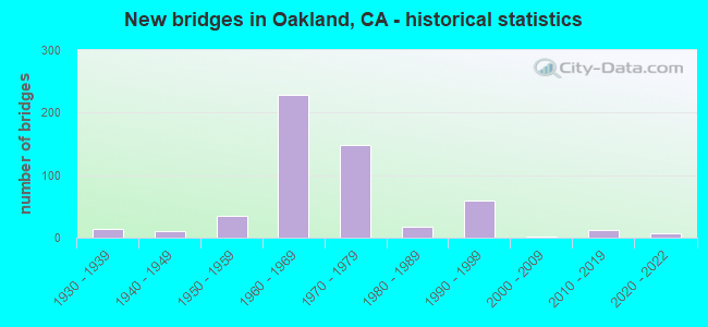
- New bridges - historical statistics
- 11900-1909
- 11910-1919
- 21920-1929
- 141930-1939
- 101940-1949
- 351950-1959
- 2281960-1969
- 1491970-1979
- 181980-1989
- 601990-1999
- 12000-2009
- 122010-2019
- 72020-2022
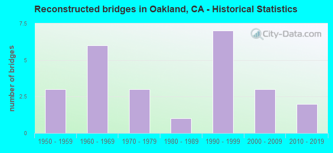
- Reconstructed bridges - Historical Statistics
- 31950-1959
- 61960-1969
- 31970-1979
- 11980-1989
- 71990-1999
- 32000-2009
- 22010-2019
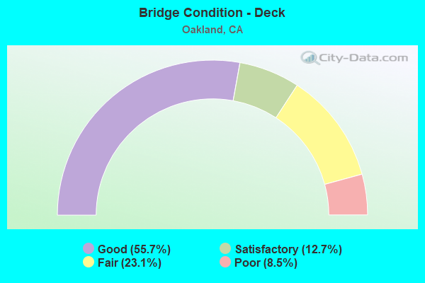
- Bridge Condition - Deck
- 55.7%Good
- 12.7%Satisfactory
- 23.1%Fair
- 8.5%Poor
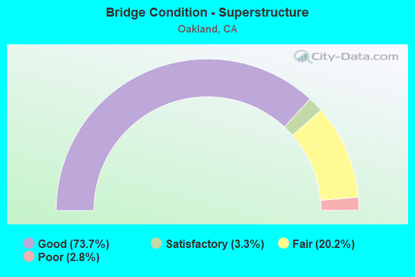
- Bridge Condition - Superstructure
- 73.7%Good
- 3.3%Satisfactory
- 20.2%Fair
- 2.8%Poor
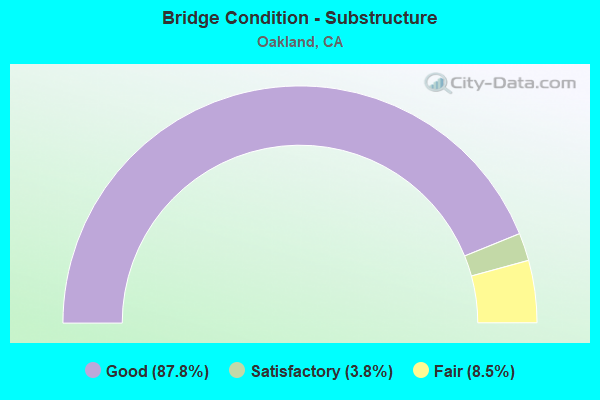
- Bridge Condition - Substructure
- 87.8%Good
- 3.8%Satisfactory
- 8.5%Fair
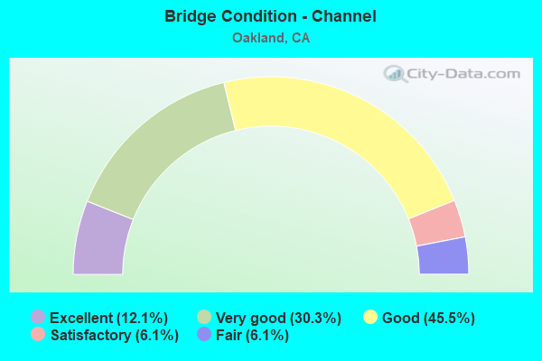
- Bridge Condition - Channel
- 12.1%Excellent
- 30.3%Very good
- 45.5%Good
- 6.1%Satisfactory
- 6.1%Fair
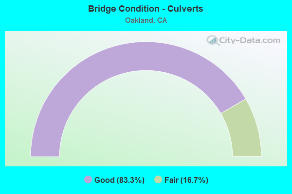
- Bridge Condition - Culverts
- 83.3%Good
- 16.7%Fair
Find on map >> Show street view
Structure Number: 33C0164, Location: 0.3 MI N COLISEUM WAY (Lat: 37.748814, Lng: -122.196142), Route carried "on" structure: City street , Year Built: 1966, Status: Open, Structure Length: 1.86m (6.10ft), Average Daily Traffic: 46,294 (year 2011), Truck Traffic: 2%, Average Future Daily Traffic: 38,934 (year 2042), Features Intersected: ELMHURST CREEK, Facility Carried by Structure: HEGENBERGER RD
Minimum Vertical Clearance: 30+ m (98+ ft), Kilometerpoint: 0.000, Lanes on structure: 8, Base Highway Network: Yes, Owner: City or Municipal Highway Agency, Approaching Roadway Width: 30.5m (100.1ft), Skew: 21 degrees, Material/Design: Concrete continuous, Design/Construction: Slab, Number Of Spans In Main Unit: 3, Length of Maximum Span: 7.0m (23.0ft), Curb or Sidewalk Widths: Left: 2.1m (6.9ft), Right: 0.9m (3.0ft), Curb-To-Curb Width: 30.5m (100.1ft), Out-to-Out Width: 34.7m (113.8ft)
Condition: Deck: Poor, Superstructure: Poor, Substructure: Good, Channel: Good, Operating Rating: 40.5 metric tons, Method Used To Determine Operating Rating: Field evaluation and documented engineering judgment, Inventory Rating: 24.3 metric tons, Method Used To Determine Inventory Rating: Field evaluation and documented engineering judgment, Structural Evaluation: Meets minimum limits, Deck Geometry: Somewhat better than minimum adequacy, Waterway Adequacy: Equal to present desirable criteria, Approach Roadway Alignment: Equal to present desirable criteria, Length Of Structure Improvement: 1.86m (6.10ft), Designated Inspection Frequency: Every 24 months, Inspection Date: September 2020, Bridge Improvement Cost: $1,485,000, Deck Structure Type: Concrete Cast-file-Place
Find on map >> Show street view
Structure Number: 33C0165, Location: 0.7 MI N I-880 (Lat: 37.749606, Lng: -122.196264), Route carried "on" structure: City street , Year Built: 1966, Status: Open, Structure Length: 9.60m (31.50ft), Average Daily Traffic: 46,294 (year 1997), Truck Traffic: 5%, Average Future Daily Traffic: 38,290 (year 2042), Design Load: HS 20+Mod, Features Intersected: UP RR,BNSF,AMTRAK,BARTD, Facility Carried by Structure: HEGENBERGER ROAD
Minimum Vertical Clearance: 30+ m (98+ ft), Kilometerpoint: 0.000, Lanes on structure: 9, Base Highway Network: Yes, Owner: City or Municipal Highway Agency, Approaching Roadway Width: 31.7m (104.0ft), Skew: 24 degrees, Material/Design: Prestressed concrete continuous, Design/Construction: Tee Beam, Number Of Spans In Main Unit: 3, Length of Maximum Span: 35.4m (116.1ft), Curb or Sidewalk Widths: Left: 1.8m (5.9ft), Right: 0.6m (2.0ft), Curb-To-Curb Width: 37.8m (124.0ft), Out-to-Out Width: 42.0m (137.8ft)
Condition: Deck: Fair, Superstructure: Good, Substructure: Satisfactory, Operating Rating: 58.3 metric tons, Method Used To Determine Operating Rating: Load Factor (LF), Inventory Rating: 32.4 metric tons, Method Used To Determine Inventory Rating: Load Factor (LF), Structural Evaluation: Equal to present minimum criteria, Deck Geometry: Equal to present minimum criteria, Underclear: Meets minimum limits, Approach Roadway Alignment: Equal to present minimum criteria, Designated Inspection Frequency: Every 24 months, Inspection Date: November 2020, Deck Structure Type: Concrete Cast-file-Place
Find on map >> Show street view
Structure Number: 33C0167, Location: BTWN SR 185 & HAMILTON (Lat: 37.757411, Lng: -122.188514), Route carried "on" structure: City street , Year Built: 1950, Year Reconstructed: 1966, Status: Open, Structure Length: 1.28m (4.20ft), Average Daily Traffic: 46,294 (year 2005), Truck Traffic: 2%, Average Future Daily Traffic: 38,290 (year 2042), Features Intersected: ARROYO VIEJO, Facility Carried by Structure: HEGENBERGER RD EB
Minimum Vertical Clearance: 30+ m (98+ ft), Kilometerpoint: 0.000, Lanes on structure: 4, Owner: City or Municipal Highway Agency, Approaching Roadway Width: 16.3m (53.5ft), Skew: 9 degrees, Material/Design: Concrete continuous, Design/Construction: Culvert, Number Of Spans In Main Unit: 2, Length of Maximum Span: 4.6m (15.1ft)
Condition: Channel: Very good, Culverts: Fair, Operating Rating: 40.5 metric tons, Method Used To Determine Operating Rating: Field evaluation and documented engineering judgment, Inventory Rating: 24.3 metric tons, Method Used To Determine Inventory Rating: Field evaluation and documented engineering judgment, Structural Evaluation: Somewhat better than minimum adequacy, Waterway Adequacy: Equal to present desirable criteria, Approach Roadway Alignment: Equal to present desirable criteria, Designated Inspection Frequency: Every 24 months, Inspection Date: November 2020
Find on map >> Show street view
Structure Number: 33C0174, Location: NEAR LESSLEY AVE (Lat: 37.686117, Lng: -122.073408), Route carried "on" structure: County highway , Year Built: 1900, Year Reconstructed: 1962, Status: Open, Structure Length: 0.82m (2.69ft), Average Daily Traffic: 29,900 (year 2014), Truck Traffic: 2%, Average Future Daily Traffic: 30,664 (year 2042), Features Intersected: REDWOOD RD FLD CNTRL CH, Facility Carried by Structure: REDWOOD RD
Minimum Vertical Clearance: 30+ m (98+ ft), Kilometerpoint: 0.000, Lanes on structure: 6, Base Highway Network: Yes, Owner: County Highway Agency, Approaching Roadway Width: 19.5m (64.0ft), Skew: 7 degrees, Material/Design: Concrete continuous, Design/Construction: Culvert, Number Of Spans In Main Unit: 2, Length of Maximum Span: 4.3m (14.1ft), Curb or Sidewalk Widths: Left: 1.8m (5.9ft), Right: 1.8m (5.9ft), Curb-To-Curb Width: 19.5m (64.0ft), Out-to-Out Width: 23.8m (78.1ft)
Condition: Channel: Good, Culverts: Good, Operating Rating: 27.2 metric tons, Method Used To Determine Operating Rating: Field evaluation and documented engineering judgment, Inventory Rating: 16.2 metric tons, Method Used To Determine Inventory Rating: Field evaluation and documented engineering judgment, Structural Evaluation: Meets minimum limits, Deck Geometry: High priority of replacement, Waterway Adequacy: Equal to present desirable criteria, Approach Roadway Alignment: Equal to present desirable criteria, Designated Inspection Frequency: Every 24 months, Inspection Date: June 2020, Deck Structure Type: Concrete Cast-file-Place, Wearing Surface/Protective System: Wearing Surface: Bituminous
Find on map >> Show street view
Structure Number: 33C0178, Location: 0.5 MI S OF SR 13 (Lat: 37.814319, Lng: -122.213239), Route carried "on" structure: City street , Year Built: 1932, Status: Open, Structure Length: 10.97m (35.99ft), Average Daily Traffic: 18,753 (year 2002), Truck Traffic: 2%, Average Future Daily Traffic: 32,387 (year 2038), Features Intersected: HILLSIDE, Facility Carried by Structure: PARK BOULEVARD
Minimum Vertical Clearance: 30+ m (98+ ft), Kilometerpoint: 0.000, Lanes on structure: 4, Base Highway Network: Yes, Owner: City or Municipal Highway Agency, Approaching Roadway Width: 17.7m (58.1ft), Material/Design: Concrete continuous, Design/Construction: Girder and Floorbeam System, Number Of Spans In Main Unit: 18, Length of Maximum Span: 6.1m (20.0ft), Curb or Sidewalk Widths: Left: 0.0m, Right: 3.3m (10.8ft), Curb-To-Curb Width: 14.5m (47.6ft), Out-to-Out Width: 6.7m (22.0ft)
Condition: Deck: Satisfactory, Superstructure: Good, Substructure: Good, Operating Rating: 27.9 metric tons, Method Used To Determine Operating Rating: Field evaluation and documented engineering judgment, Inventory Rating: 16.8 metric tons, Method Used To Determine Inventory Rating: Field evaluation and documented engineering judgment, Structural Evaluation: Meets minimum limits, Deck Geometry: High priority of replacement, Approach Roadway Alignment: Equal to present desirable criteria, Designated Inspection Frequency: Every 24 months, Inspection Date: November 2020, Deck Structure Type: Concrete Cast-file-Place, Wearing Surface/Protective System: Wearing Surface: Bituminous
Find on map >> Show street view
Structure Number: 33C0179, Location: 0.4 MI SW OF SR 13 (Lat: 37.816300, Lng: -122.212581), Route carried "on" structure: City street , Year Built: 1932, Status: Open, Structure Length: 6.10m (20.01ft), Average Daily Traffic: 18,753 (year 2002), Truck Traffic: 2%, Average Future Daily Traffic: 32,387 (year 2038), Features Intersected: HILLSIDE, Facility Carried by Structure: PARK BOULEVARD
Minimum Vertical Clearance: 30+ m (98+ ft), Kilometerpoint: 0.000, Lanes on structure: 4, Base Highway Network: Yes, Owner: City or Municipal Highway Agency, Approaching Roadway Width: 17.7m (58.1ft), Material/Design: Concrete continuous, Design/Construction: Girder and Floorbeam System, Number Of Spans In Main Unit: 10, Length of Maximum Span: 6.1m (20.0ft), Curb or Sidewalk Widths: Left: 0.0m, Right: 3.3m (10.8ft), Curb-To-Curb Width: 14.2m (46.6ft), Out-to-Out Width: 9.7m (31.8ft)
Condition: Deck: Satisfactory, Superstructure: Good, Substructure: Good, Operating Rating: 27.9 metric tons, Method Used To Determine Operating Rating: Field evaluation and documented engineering judgment, Inventory Rating: 16.8 metric tons, Method Used To Determine Inventory Rating: Field evaluation and documented engineering judgment, Structural Evaluation: Meets minimum limits, Deck Geometry: High priority of replacement, Approach Roadway Alignment: Superior to present desirable criteria, Designated Inspection Frequency: Every 24 months, Inspection Date: November 2020, Deck Structure Type: Concrete Cast-file-Place, Wearing Surface/Protective System: Wearing Surface: Bituminous
Find on map >> Show street view
Structure Number: 33C018, Location: 0.3 MI SW OF SR 13 (Lat: 37.817475, Lng: -122.211672), Route carried "on" structure: City street , Year Built: 1932, Status: Open, Structure Length: 4.88m (16.01ft), Average Daily Traffic: 18,753 (year 2002), Truck Traffic: 2%, Average Future Daily Traffic: 32,821 (year 2042), Features Intersected: HILLSIDE, Facility Carried by Structure: PARK BOULEVARD
Minimum Vertical Clearance: 30+ m (98+ ft), Kilometerpoint: 0.000, Lanes on structure: 4, Owner: City or Municipal Highway Agency, Approaching Roadway Width: 17.7m (58.1ft), Material/Design: Concrete continuous, Design/Construction: Girder and Floorbeam System, Number Of Spans In Main Unit: 8, Length of Maximum Span: 6.1m (20.0ft), Curb or Sidewalk Widths: Left: 0.0m, Right: 3.3m (10.8ft), Curb-To-Curb Width: 14.1m (46.3ft), Out-to-Out Width: 12.6m (41.3ft)
Condition: Deck: Satisfactory, Superstructure: Satisfactory, Substructure: Good, Operating Rating: 26.9 metric tons, Method Used To Determine Operating Rating: Field evaluation and documented engineering judgment, Inventory Rating: 16.2 metric tons, Method Used To Determine Inventory Rating: Field evaluation and documented engineering judgment, Structural Evaluation: Meets minimum limits, Deck Geometry: High priority of replacement, Approach Roadway Alignment: Equal to present desirable criteria, Designated Inspection Frequency: Every 24 months, Inspection Date: November 2020, Deck Structure Type: Concrete Cast-file-Place, Wearing Surface/Protective System: Wearing Surface: Bituminous
Find on map >> Show street view
Structure Number: 33C0202, Location: 0.4 MI SOUTH OF 66TH AVE (Lat: 37.751444, Lng: -122.196194), Route carried "on" structure: City street , Year Built: 1966, Year Reconstructed: 2014, Status: Open, Structure Length: 27.40m (89.90ft), Average Daily Traffic: 20,904 (year 2003), Truck Traffic: 5%, Average Future Daily Traffic: 38,036 (year 2040), Features Intersected: BARTD, UPRR, SAN LEANDRO, Facility Carried by Structure: HEGENBERGER ROAD
Minimum Vertical Clearance: 30+ m (98+ ft), Kilometerpoint: 0.000, Lanes on structure: 6, Lanes under structure: 6, Base Highway Network: Yes, Owner: City or Municipal Highway Agency, Approaching Roadway Width: 25.9m (85.0ft), Skew: 20 degrees, Material/Design: Prestressed concrete continuous, Design/Construction: Tee Beam, Number Of Spans In Main Unit: 5, Length of Maximum Span: 88.4m (290.0ft), Curb or Sidewalk Widths: Left: 0.6m (2.0ft), Right: 0.6m (2.0ft), Curb-To-Curb Width: 23.2m (76.1ft), Out-to-Out Width: 26.2m (86.0ft)
Condition: Deck: Satisfactory, Superstructure: Good, Substructure: Satisfactory, Operating Rating: 79.4 metric tons, Method Used To Determine Operating Rating: Load Factor (LF), Inventory Rating: 32.4 metric tons, Method Used To Determine Inventory Rating: Load Factor (LF), Structural Evaluation: Equal to present minimum criteria, Deck Geometry: Meets minimum limits, Underclear: High priority of corrective action, Approach Roadway Alignment: Equal to present minimum criteria, Designated Inspection Frequency: Every 24 months, Inspection Date: November 2020, Deck Structure Type: Concrete Cast-file-Place
Find on map >> Show street view
Structure Number: 33C0215, Location: 0.1 MI E OF PARK BLVD (Lat: 37.812331, Lng: -122.213806), Route carried "on" structure: City street , Year Built: 1926, Status: Open, Structure Length: 10.88m (35.70ft), Average Daily Traffic: 7,335 (year 2003), Truck Traffic: 5%, Average Future Daily Traffic: 10,940 (year 2042), Features Intersected: SAUSAL CREEK, Facility Carried by Structure: LEIMERT BLVD
Minimum Vertical Clearance: 30+ m (98+ ft), Kilometerpoint: 0.000, Lanes on structure: 2, Owner: City or Municipal Highway Agency, Approaching Roadway Width: 8.5m (27.9ft), Material/Design: Concrete, Design/Construction: Arch - Deck, Number Of Spans In Main Unit: 1, Number Of Approach Spans: 8, Length of Maximum Span: 52.7m (172.9ft), Curb or Sidewalk Widths: Left: 1.2m (3.9ft), Right: 1.2m (3.9ft), Curb-To-Curb Width: 7.3m (24.0ft), Out-to-Out Width: 10.5m (34.4ft)
Condition: Deck: Satisfactory, Superstructure: Satisfactory, Substructure: Satisfactory, Channel: Fair, Operating Rating: 28.2 metric tons, Method Used To Determine Operating Rating: Field evaluation and documented engineering judgment, Inventory Rating: 16.8 metric tons, Method Used To Determine Inventory Rating: Field evaluation and documented engineering judgment, Structural Evaluation: Meets minimum limits, Deck Geometry: High priority of replacement, Waterway Adequacy: Superior to present desirable criteria, Approach Roadway Alignment: Equal to present minimum criteria, Designated Inspection Frequency: Every 24 months, Inspection Date: November 2020, Deck Structure Type: Concrete Cast-file-Place, Wearing Surface/Protective System: Wearing Surface: Bituminous
Find on map >> Show street view
Structure Number: 33C0216, Location: NEAR 69TH AVE (Lat: 37.755986, Lng: -122.199208), Route carried "on" structure: City street , Year Built: 1940, Year Reconstructed: 1965, Status: Open, Structure Length: 1.07m (3.51ft), Average Daily Traffic: 20,904 (year 2003), Truck Traffic: 5%, Average Future Daily Traffic: 32,821 (year 2042), Features Intersected: LION CREEK, Facility Carried by Structure: SAN LEANDRO, UP RR
Minimum Vertical Clearance: 30+ m (98+ ft), Kilometerpoint: 0.000, Lanes on structure: 4, Owner: City or Municipal Highway Agency, Approaching Roadway Width: 23.2m (76.1ft), Skew: 1 degrees, Material/Design: Concrete continuous, Design/Construction: Culvert, Number Of Spans In Main Unit: 3, Length of Maximum Span: 3.0m (9.8ft), Curb or Sidewalk Widths: Left: 2.4m (7.9ft), Right: 2.0m (6.6ft), Curb-To-Curb Width: 18.7m (61.4ft), Out-to-Out Width: 26.0m (85.3ft)
Condition: Channel: Good, Culverts: Good, Operating Rating: 27.2 metric tons, Method Used To Determine Operating Rating: Field evaluation and documented engineering judgment, Inventory Rating: 16.2 metric tons, Method Used To Determine Inventory Rating: Field evaluation and documented engineering judgment, Structural Evaluation: Meets minimum limits, Deck Geometry: Equal to present minimum criteria, Waterway Adequacy: Equal to present desirable criteria, Approach Roadway Alignment: Equal to present desirable criteria, Designated Inspection Frequency: Every 24 months, Inspection Date: November 2020, Deck Structure Type: Concrete Cast-file-Place, Wearing Surface/Protective System: Wearing Surface: Bituminous
Find on map >> Show street view
Structure Number: 33C0218, Location: 0.3 MI W OF I 880 (Lat: 37.729806, Lng: -122.192678), Route carried "on" structure: City street , Year Built: 1939, Year Reconstructed: 2002, Status: Open, Structure Length: 3.87m (12.70ft), Average Daily Traffic: 7,991 (year 2003), Truck Traffic: 5%, Average Future Daily Traffic: 5,524 (year 2040), Features Intersected: SAN LEANDRO CREEK, Facility Carried by Structure: 98TH AVE
Minimum Vertical Clearance: 30+ m (98+ ft), Kilometerpoint: 0.000, Lanes on structure: 6, Owner: City or Municipal Highway Agency, Approaching Roadway Width: 11.6m (38.1ft), Skew: 20 degrees, Material/Design: Concrete continuous, Design/Construction: Tee Beam, Number Of Spans In Main Unit: 9, Length of Maximum Span: 4.3m (14.1ft), Curb or Sidewalk Widths: Left: 1.5m (4.9ft), Right: 1.5m (4.9ft), Curb-To-Curb Width: 23.2m (76.1ft), Out-to-Out Width: 30.0m (98.4ft)
Condition: Deck: Poor, Superstructure: Poor, Substructure: Fair, Channel: Good, Operating Rating: 26.9 metric tons, Method Used To Determine Operating Rating: Field evaluation and documented engineering judgment, Inventory Rating: 16.2 metric tons, Method Used To Determine Inventory Rating: Field evaluation and documented engineering judgment, Structural Evaluation: Meets minimum limits, Deck Geometry: Meets minimum limits, Waterway Adequacy: Equal to present desirable criteria, Approach Roadway Alignment: Equal to present desirable criteria, Length Of Structure Improvement: 3.87m (12.70ft), Designated Inspection Frequency: Every 24 months, Inspection Date: September 2020, Bridge Improvement Cost: $1,161,000, Roadway Improvement Cost: $232,000, Total Project Cost: $1,950,000 ( Estimate for 2017), Deck Structure Type: Concrete Cast-file-Place
Find on map >> Show street view
Structure Number: 33C0238, Location: 0.5 MI SE REDWOD RD (Lat: 37.794622, Lng: -122.170181), Route carried "on" structure: City street , Year Built: 1970, Status: Open, Structure Length: 9.33m (30.61ft), Average Daily Traffic: 7,991 (year 2003), Truck Traffic: 5%, Average Future Daily Traffic: 21,880 (year 2042), Design Load: HS 20, Features Intersected: LION CREEK TRIBUTARY, Facility Carried by Structure: CAMPUS DR
Minimum Vertical Clearance: 30+ m (98+ ft), Kilometerpoint: 0.000, Lanes on structure: 4, Owner: City or Municipal Highway Agency, Approaching Roadway Width: 15.8m (51.8ft), Material/Design: Prestressed concrete continuous, Design/Construction: Stringer/Multi-beam, Number Of Spans In Main Unit: 5, Length of Maximum Span: 18.9m (62.0ft), Curb or Sidewalk Widths: Left: 2.4m (7.9ft), Right: 2.4m (7.9ft), Curb-To-Curb Width: 15.8m (51.8ft), Out-to-Out Width: 21.2m (69.6ft)
Condition: Deck: Poor, Superstructure: Good, Substructure: Good, Channel: Good, Operating Rating: 64.2 metric tons, Method Used To Determine Operating Rating: Load Factor (LF), Inventory Rating: 32.4 metric tons, Method Used To Determine Inventory Rating: Load Factor (LF), Structural Evaluation: Better than present minimum criteria, Deck Geometry: Meets minimum limits, Waterway Adequacy: Superior to present desirable criteria, Approach Roadway Alignment: Equal to present minimum criteria, Length Of Structure Improvement: 9.33m (30.61ft), Designated Inspection Frequency: Every 24 months, Inspection Date: November 2020, Bridge Improvement Cost: $1,976,000, Roadway Improvement Cost: $395,000, Total Project Cost: $3,319,000 ( Estimate for 2017), Deck Structure Type: Concrete Cast-file-Place
Find on map >> Show street view
Structure Number: 33C024, Location: 0.2 MI N TESLA RD (Lat: 37.668467, Lng: -121.696636), Route carried "on" structure: County highway , Year Built: 1962, Status: Open, Structure Length: 2.67m (8.76ft), Average Daily Traffic: 4,300 (year 2014), Truck Traffic: 12%, Average Future Daily Traffic: 4,505 (year 2043), Design Load: HS 20, Features Intersected: ARROYO SECO, Facility Carried by Structure: GREENVILLE RD
Minimum Vertical Clearance: 30+ m (98+ ft), Kilometerpoint: 0.000, Lanes on structure: 2, Owner: County Highway Agency, Approaching Roadway Width: 12.2m (40.0ft), Skew: 1 degrees, Material/Design: Concrete continuous, Design/Construction: Slab, Number Of Spans In Main Unit: 3, Length of Maximum Span: 10.4m (34.1ft), Curb-To-Curb Width: 12.2m (40.0ft), Out-to-Out Width: 12.4m (40.7ft)
Condition: Deck: Poor, Superstructure: Poor, Substructure: Good, Channel: Good, Operating Rating: 71.9 metric tons, Method Used To Determine Operating Rating: Load Factor (LF), Inventory Rating: 43.1 metric tons, Method Used To Determine Inventory Rating: Load Factor (LF), Structural Evaluation: Meets minimum limits, Deck Geometry: Equal to present minimum criteria, Waterway Adequacy: Superior to present desirable criteria, Approach Roadway Alignment: Equal to present desirable criteria, Length Of Structure Improvement: 2.67m (8.76ft), Designated Inspection Frequency: Every 24 months, Inspection Date: November 2021, Bridge Improvement Cost: $327,000, Roadway Improvement Cost: $65,000, Total Project Cost: $549,000 ( Estimate for 2018), Deck Structure Type: Concrete Cast-file-Place
Find on map >> Show street view
Structure Number: 33C0253, Location: 50' S OF 66TH AVE (Lat: 37.754314, Lng: -122.204106), Route carried "on" structure: City street , Year Built: 1980, Year Reconstructed: 2014, Status: Open, Structure Length: 5.30m (17.39ft), Average Daily Traffic: 1,200 (year 1982), Truck Traffic: 1%, Average Future Daily Traffic: 2,187 (year 2042), Features Intersected: DAMON SLOUGH, Facility Carried by Structure: COLISEUM WAY
Minimum Vertical Clearance: 30+ m (98+ ft), Kilometerpoint: 0.000, Lanes on structure: 6, Owner: City or Municipal Highway Agency, Approaching Roadway Width: 26.8m (87.9ft), Skew: 3 degrees, Material/Design: Prestressed concrete, Design/Construction: Stringer/Multi-beam, Number Of Spans In Main Unit: 4, Length of Maximum Span: 13.2m (43.3ft), Curb or Sidewalk Widths: Left: 2.7m (8.9ft), Right: 2.7m (8.9ft), Curb-To-Curb Width: 26.8m (87.9ft), Out-to-Out Width: 32.9m (107.9ft)
Condition: Deck: Good, Superstructure: Good, Substructure: Good, Channel: Good, Operating Rating: 65.1 metric tons, Method Used To Determine Operating Rating: Load Factor (LF), Inventory Rating: 39.2 metric tons, Method Used To Determine Inventory Rating: Load Factor (LF), Structural Evaluation: Better than present minimum criteria, Deck Geometry: Better than present minimum criteria, Waterway Adequacy: Equal to present desirable criteria, Approach Roadway Alignment: Equal to present minimum criteria, Designated Inspection Frequency: Every 48 months, Inspection Date: November 2020, Deck Structure Type: Concrete Cast-file-Place, Wearing Surface/Protective System: Wearing Surface: Bituminous
Find on map >> Show street view
Structure Number: 33C0373R, Location: 0.2 MI N/W ROLAND WAY (Lat: 37.744225, Lng: -122.204950), Route carried "on" structure: City street , Year Built: 1968, Status: Open, Structure Length: 2.74m (8.99ft), Average Daily Traffic: 15,273 (year 1997), Truck Traffic: 10%, Average Future Daily Traffic: 2,173 (year 2040), Features Intersected: ELMHURST CANAL, Facility Carried by Structure: EDGEWATER DRIVE NB
Minimum Vertical Clearance: 30+ m (98+ ft), Kilometerpoint: 0.000, Lanes on structure: 2, Owner: City or Municipal Highway Agency, Approaching Roadway Width: 8.5m (27.9ft), Material/Design: Concrete continuous, Design/Construction: Slab, Number Of Spans In Main Unit: 3, Length of Maximum Span: 11.0m (36.1ft), Curb or Sidewalk Widths: Left: 0.8m (2.6ft), Right: 1.7m (5.6ft), Curb-To-Curb Width: 8.5m (27.9ft), Out-to-Out Width: 12.2m (40.0ft)
Condition: Deck: Fair, Superstructure: Fair, Substructure: Fair, Channel: Satisfactory, Operating Rating: 32.7 metric tons, Method Used To Determine Operating Rating: Field evaluation and documented engineering judgment, Inventory Rating: 19.8 metric tons, Method Used To Determine Inventory Rating: Field evaluation and documented engineering judgment, Structural Evaluation: Somewhat better than minimum adequacy, Deck Geometry: High priority of corrective action, Waterway Adequacy: Equal to present desirable criteria, Approach Roadway Alignment: Equal to present desirable criteria, Designated Inspection Frequency: Every 24 months, Inspection Date: November 2020, Deck Structure Type: Concrete Cast-file-Place
Find on map >> Show street view
Structure Number: 33C0393, Location: 0.04 MI W/O WILLOW STREET (Lat: 37.817903, Lng: -122.291336), Route carried "on" structure: City street , Year Built: 1997, Status: Open, Structure Length: 101.40m (332.68ft), Average Daily Traffic: 22,323 (year 1999), Truck Traffic: 2%, Average Future Daily Traffic: 38,290 (year 2042), Design Load: HS 20+Mod, Features Intersected: UPRR, BNSF, AMTRAK, WOOD, Facility Carried by Structure: WEST GRAND AVENUE
Minimum Vertical Clearance: 5.20m (17.06ft), Kilometerpoint: 0.000, Lanes on structure: 4, Lanes under structure: 2, Base Highway Network: Yes, Owner: State Highway Agency, Approaching Roadway Width: 23.1m (75.8ft), Material/Design: Prestressed concrete, Design/Construction: Tee Beam, Number Of Spans In Main Unit: 35, Number Of Approach Spans: 9, Length of Maximum Span: 44.2m (145.0ft), Curb or Sidewalk Widths: Left: 0.0m, Right: 1.5m (4.9ft), Curb-To-Curb Width: 23.1m (75.8ft), Out-to-Out Width: 25.5m (83.7ft)
Condition: Deck: Fair, Superstructure: Fair, Substructure: Good, Operating Rating: 54.1 metric tons, Method Used To Determine Operating Rating: Assigned rating based on Load Factor Design (LFD) reported in metric tons, Inventory Rating: 32.4 metric tons, Method Used To Determine Inventory Rating: Assigned rating based on Load Factor Design (LFD) reported in metric tons, Structural Evaluation: Somewhat better than minimum adequacy, Deck Geometry: Superior to present desirable criteria, Underclear: Superior to present desirable criteria, Approach Roadway Alignment: Equal to present desirable criteria, Designated Inspection Frequency: Every 24 months, Inspection Date: November 2020, Deck Structure Type: Concrete Cast-file-Place
Find on map >> Show street view
Structure Number: 33C0396, Location: 0.1 KM WEST OF I-880 (Lat: 37.807869, Lng: -122.305639), Route carried "on" structure: ServiceCity street , Year Built: 1997, Status: Open, Structure Length: 3.68m (12.07ft), Average Daily Traffic: 22,323 (year 1999), Truck Traffic: 2%, Average Future Daily Traffic: 38,291 (year 2042), Features Intersected: 7TH STREET, Facility Carried by Structure: BAY ST
Minimum Vertical Clearance: 30+ m (98+ ft), Kilometerpoint: 0.000, Lanes on structure: 2, Lanes under structure: 5, Owner: City or Municipal Highway Agency, Approaching Roadway Width: 7.7m (25.3ft), Skew: 1 degrees, Material/Design: Prestressed concrete continuous, Design/Construction: Box Beam or Girders - Multiple, Number Of Spans In Main Unit: 2, Length of Maximum Span: 19.6m (64.3ft), Curb-To-Curb Width: 6.7m (22.0ft), Out-to-Out Width: 7.8m (25.6ft)
Condition: Deck: Satisfactory, Superstructure: Good, Substructure: Satisfactory, Operating Rating: 42.4 metric tons, Method Used To Determine Operating Rating: Load and Resistance Factor Rating (LRFR) rating reported by rating factor(RF) method using HL-93 loadings, Inventory Rating: 27.9 metric tons, Method Used To Determine Inventory Rating: Load and Resistance Factor Rating (LRFR) rating reported by rating factor(RF) method using HL-93 loadings, Structural Evaluation: Equal to present minimum criteria, Deck Geometry: High priority of replacement, Underclear: Equal to present minimum criteria, Approach Roadway Alignment: Equal to present desirable criteria, Designated Inspection Frequency: Every 24 months, Inspection Date: November 2020, Deck Structure Type: Concrete Cast-file-Place
Find on map >> Show street view
Structure Number: 33C0472R, Location: JUST W LAKESHORE AVE (Lat: 37.798042, Lng: -122.259869), Route carried "on" structure: City street , Year Built: 2012, Status: Open, Structure Length: 4.40m (14.44ft), Average Daily Traffic: 7,754 (year 2007), Truck Traffic: 2%, Average Future Daily Traffic: 27,260 (year 2040), Design Load: HS 20, Features Intersected: LAKE MERRITT CHANNEL, Facility Carried by Structure: E 14TH STREET
Minimum Vertical Clearance: 30+ m (98+ ft), Kilometerpoint: 0.000, Lanes on structure: 3, Owner: City or Municipal Highway Agency, Approaching Roadway Width: 12.8m (42.0ft), Material/Design: Prestressed concrete, Design/Construction: Box Beam or Girders - Multiple, Number Of Spans In Main Unit: 1, Length of Maximum Span: 44.0m (144.4ft), Curb or Sidewalk Widths: Left: 0.0m, Right: 4.0m (13.1ft), Curb-To-Curb Width: 12.8m (42.0ft), Out-to-Out Width: 18.3m (60.0ft)
Condition: Deck: Good, Superstructure: Good, Substructure: Good, Channel: Very good, Operating Rating: 54.1 metric tons, Method Used To Determine Operating Rating: Assigned rating based on Load Factor Design (LFD) reported in metric tons, Inventory Rating: 32.4 metric tons, Method Used To Determine Inventory Rating: Assigned rating based on Load Factor Design (LFD) reported in metric tons, Structural Evaluation: Better than present minimum criteria, Deck Geometry: Meets minimum limits, Waterway Adequacy: Equal to present desirable criteria, Approach Roadway Alignment: Equal to present desirable criteria, Designated Inspection Frequency: Every 24 months, Inspection Date: November 2020, Deck Structure Type: Concrete Cast-file-Place
Find on map >> Show street view
Structure Number: 28 0283L, Location: 04-CC-024-R0.28 (Lat: 37.861122, Lng: -122.209681), Route carried "under" structure: State highway 24, Year Built: 1964, Structure Length: 0. m, Average Daily Traffic: 155,000 (year 2017), Features Intersected: STATE ROUTE 24, Facility Carried by Structure: EAST PORTAL BLDG
Minimum Vertical Clearance: 5.10m (16.73ft), Kilometerpoint: 0.280, Lanes on structure: 1, Lanes under structure: 2, Material/Design: Concrete, Design/Construction: Box Beam or Girders - Multiple, Length of Maximum Span: 11.0m (36.1ft)
Find on map >> Show street view
Structure Number: 33 0041, Location: 04-ALA-880-28.24-OAK (Lat: 37.773172, Lng: -122.227425), Route carried "under" structure: City street , Year Built: 1947, Structure Length: 0. m, Average Daily Traffic: 19,147 (year 1999), Truck Traffic: 6%, Features Intersected: UP RR SPUR,FRUITVALE AVE, Facility Carried by Structure: INTERSTATE 880
Minimum Vertical Clearance: 7.18m (23.56ft), Kilometerpoint: 0.000, Lanes on structure: 8, Lanes under structure: 4, Material/Design: Steel continuous, Design/Construction: Stringer/Multi-beam, Length of Maximum Span: 25.9m (85.0ft)
Find on map >> Show street view
Structure Number: 33 0061L, Location: 04-ALA-580-46.50L-OAK (Lat: 37.827003, Lng: -122.284458), Route carried "under" structure: Interstate 880, Year Built: 1955, Structure Length: 0. m, Average Daily Traffic: 36,700 (year 2019), Truck Traffic: 3%, Features Intersected: UP RR,BNSF RY,AMTRAK,ETC, Facility Carried by Structure: E&W80-E580 CONNCTR
Minimum Vertical Clearance: 4.72m (15.49ft), Kilometerpoint: 34.500, Lanes on structure: 2, Lanes under structure: 2, Material/Design: Steel, Design/Construction: Stringer/Multi-beam, Length of Maximum Span: 37.2m (122.0ft)
Find on map >> Show street view
Structure Number: 33 0061L, Location: 04-ALA-580-46.50L-OAK (Lat: 37.827003, Lng: -122.284458), Route carried "under" structure: City street , Year Built: 1955, Structure Length: 0. m, Average Daily Traffic: 3,000 (year 2009), Truck Traffic: 3%, Features Intersected: UP RR,BNSF RY,AMTRAK,ETC, Facility Carried by Structure: E&W80-E580 CONNCTR
Minimum Vertical Clearance: 12.54m (41.14ft), Kilometerpoint: 0.000, Lanes on structure: 2, Lanes under structure: 2, Material/Design: Steel, Design/Construction: Stringer/Multi-beam, Length of Maximum Span: 37.2m (122.0ft)
Find on map >> Show street view
Structure Number: 33 0061L, Location: 04-ALA-580-46.50L-OAK (Lat: 37.827003, Lng: -122.284458), Route carried "under" structure: City street , Year Built: 1955, Structure Length: 0. m, Average Daily Traffic: 5,000 (year 2009), Truck Traffic: 3%, Features Intersected: UP RR,BNSF RY,AMTRAK,ETC, Facility Carried by Structure: E&W80-E580 CONNCTR
Minimum Vertical Clearance: 4.64m (15.22ft), Kilometerpoint: 0.000, Lanes on structure: 2, Lanes under structure: 2, Material/Design: Steel, Design/Construction: Stringer/Multi-beam, Length of Maximum Span: 37.2m (122.0ft)
Find on map >> Show street view
Structure Number: 33 0061L, Location: 04-ALA-580-46.50L-OAK (Lat: 37.827003, Lng: -122.284458), Route carried "under" structure: City street , Year Built: 1955, Structure Length: 0. m, Average Daily Traffic: 5,000 (year 2009), Truck Traffic: 10%, Features Intersected: UP RR,BNSF RY,AMTRAK,ETC, Facility Carried by Structure: E&W80-E580 CONNCTR
Minimum Vertical Clearance: 11.32m (37.14ft), Kilometerpoint: 0.000, Lanes on structure: 2, Lanes under structure: 4, Material/Design: Steel, Design/Construction: Stringer/Multi-beam, Length of Maximum Span: 37.2m (122.0ft)
Find on map >> Show street view
Structure Number: 33 0061R, Location: 04-ALA-580-46.50R-OAK (Lat: 37.827325, Lng: -122.284556), Route carried "under" structure: Ramp Interstate 580, Year Built: 1935, Structure Length: 0. m, Average Daily Traffic: 57,200 (year 2019), Truck Traffic: 2%, Features Intersected: UP RR,BNSF RY,AMTRAK,ETC
Minimum Vertical Clearance: 4.49m (14.73ft), Kilometerpoint: 46.500, Lanes on structure: 2, Lanes under structure: 2, Material/Design: Steel, Design/Construction: Stringer/Multi-beam, Length of Maximum Span: 38.4m (126.0ft)
Find on map >> Show street view
Structure Number: 33 0061R, Location: 04-ALA-580-46.50R-OAK (Lat: 37.827325, Lng: -122.284556), Route carried "under" structure: Interstate 880, Year Built: 1935, Structure Length: 0. m, Average Daily Traffic: 36,700 (year 2019), Truck Traffic: 14%, Features Intersected: UP RR,BNSF RY,AMTRAK,ETC, Facility Carried by Structure: W580-E&W80 CONNCTR
Minimum Vertical Clearance: 4.64m (15.22ft), Kilometerpoint: 34.500, Lanes on structure: 2, Lanes under structure: 2, Material/Design: Steel, Design/Construction: Stringer/Multi-beam, Length of Maximum Span: 38.4m (126.0ft)
Find on map >> Show street view
Structure Number: 33 0061R, Location: 04-ALA-580-46.50R-OAK (Lat: 37.827325, Lng: -122.284556), Route carried "under" structure: City street , Year Built: 1935, Structure Length: 0. m, Average Daily Traffic: 5,000 (year 2009), Truck Traffic: 10%, Features Intersected: UP RR,BNSF RY,AMTRAK,ETC, Facility Carried by Structure: W580-E&W80 CONNCTR
Minimum Vertical Clearance: 8.02m (26.31ft), Kilometerpoint: 0.000, Lanes on structure: 2, Lanes under structure: 4, Material/Design: Steel, Design/Construction: Stringer/Multi-beam, Length of Maximum Span: 38.4m (126.0ft)
Find on map >> Show street view
Structure Number: 33 0061R, Location: 04-ALA-580-46.50R-OAK (Lat: 37.827325, Lng: -122.284556), Route carried "under" structure: City street , Year Built: 1935, Structure Length: 0. m, Average Daily Traffic: 3,000 (year 2009), Truck Traffic: 3%, Features Intersected: UP RR,BNSF RY,AMTRAK,ETC, Facility Carried by Structure: W580-E&W80 CONNCTR
Minimum Vertical Clearance: 7.82m (25.66ft), Kilometerpoint: 0.000, Lanes on structure: 2, Lanes under structure: 2, Material/Design: Steel, Design/Construction: Stringer/Multi-beam, Length of Maximum Span: 38.4m (126.0ft)
Find on map >> Show street view
Structure Number: 33 0061R, Location: 04-ALA-580-46.50R-OAK (Lat: 37.827325, Lng: -122.284556), Route carried "under" structure: City street , Year Built: 1935, Structure Length: 0. m, Average Daily Traffic: 5,000 (year 2009), Truck Traffic: 3%, Features Intersected: UP RR,BNSF RY,AMTRAK,ETC, Facility Carried by Structure: W580-E&W80 CONNCTR
Minimum Vertical Clearance: 4.72m (15.49ft), Kilometerpoint: 0.000, Lanes on structure: 2, Lanes under structure: 2, Material/Design: Steel, Design/Construction: Stringer/Multi-beam, Length of Maximum Span: 38.4m (126.0ft)
Find on map >> Show street view
Structure Number: 33 0061R, Location: 04-ALA-580-46.50R-OAK (Lat: 37.827325, Lng: -122.284556), Route carried "under" structure: Interstate 80, Year Built: 1935, Structure Length: 0. m, Average Daily Traffic: 13,800 (year 2019), Truck Traffic: 2%, Features Intersected: UP RR,BNSF RY,AMTRAK,ETC
Minimum Vertical Clearance: 6.04m (19.82ft), Kilometerpoint: 2.800, Lanes on structure: 2, Lanes under structure: 3, Material/Design: Steel, Design/Construction: Stringer/Multi-beam, Length of Maximum Span: 38.4m (126.0ft)
Find on map >> Show street view
Structure Number: 33 0088L, Location: 04-ALA-880-25.50-OAK (Lat: 37.739969, Lng: -122.196458), Route carried "under" structure: Interstate 880, Year Built: 1996, Structure Length: 0. m, Average Daily Traffic: 199,000 (year 2009), Truck Traffic: 7%, Features Intersected: INTERSTATE 880, Facility Carried by Structure: HEGENBERGER RD WB
Minimum Vertical Clearance: 5.54m (18.18ft), Kilometerpoint: 25.500, Lanes on structure: 4, Lanes under structure: 10, Material/Design: Prestressed concrete continuous, Design/Construction: Box Beam or Girders - Multiple, Length of Maximum Span: 65.5m (214.9ft)
Find on map >> Show street view
Structure Number: 33 0088R, Location: 04-ALA-880-25.49-OAK (Lat: 37.739722, Lng: -122.196217), Route carried "under" structure: Interstate 880, Year Built: 1976, Structure Length: 0. m, Average Daily Traffic: 199,000 (year 2009), Truck Traffic: 7%, Features Intersected: INTERSTATE 880, Facility Carried by Structure: HEGENBERGER RD EB
Minimum Vertical Clearance: 5.18m (16.99ft), Kilometerpoint: 25.490, Lanes on structure: 4, Lanes under structure: 10, Material/Design: Prestressed concrete continuous, Design/Construction: Stringer/Multi-beam, Length of Maximum Span: 37.2m (122.0ft)
Find on map >> Show street view
Structure Number: 33 0105L, Location: 04-ALA-013-5.01-OAK (Lat: 37.793714, Lng: -122.181875), Route carried "under" structure: City street , Year Built: 1966, Structure Length: 0. m, Average Daily Traffic: 5,000 (year 2009), Truck Traffic: 1%, Features Intersected: CARSON STREET, Facility Carried by Structure: STATE ROUTE 13 SB
Minimum Vertical Clearance: 5.51m (18.08ft), Kilometerpoint: 0.000, Lanes on structure: 2, Lanes under structure: 4, Material/Design: Concrete continuous, Design/Construction: Box Beam or Girders - Multiple, Length of Maximum Span: 24.8m (81.4ft)
Find on map >> Show street view
Structure Number: 33 0105R, Location: 04-ALA-013-5.01-OAK (Lat: 37.793894, Lng: -122.181700), Route carried "under" structure: City street , Year Built: 1966, Structure Length: 0. m, Average Daily Traffic: 5,000 (year 2009), Truck Traffic: 1%, Features Intersected: CARSON STREET, Facility Carried by Structure: STATE ROUTE 13 NB
Minimum Vertical Clearance: 4.59m (15.06ft), Kilometerpoint: 0.000, Lanes on structure: 2, Lanes under structure: 4, Material/Design: Concrete continuous, Design/Construction: Box Beam or Girders - Multiple, Length of Maximum Span: 24.8m (81.4ft)
Find on map >> Show street view
Structure Number: 33 011, Location: 04-ALA-880-24.74-OAK (Lat: 37.731364, Lng: -122.188894), Route carried "under" structure: Interstate 880, Year Built: 1998, Structure Length: 0. m, Average Daily Traffic: 199,000 (year 2009), Truck Traffic: 7%, Features Intersected: INTERSTATE 880, Facility Carried by Structure: 98TH AVE
Minimum Vertical Clearance: 5.76m (18.90ft), Kilometerpoint: 24.740, Lanes on structure: 6, Lanes under structure: 8, Material/Design: Prestressed concrete continuous, Design/Construction: Box Beam or Girders - Multiple, Length of Maximum Span: 47.8m (156.8ft)
Find on map >> Show street view
Structure Number: 33 0131, Location: 04-ALA-580-43.48-OAK (Lat: 37.809817, Lng: -122.245992), Route carried "under" structure: City street , Year Built: 1962, Structure Length: 0. m, Average Daily Traffic: 24,720 (year 2009), Truck Traffic: 3%, Features Intersected: LAKESHORE BL & GRAND AVE, Facility Carried by Structure: INTERSTATE 580
Minimum Vertical Clearance: 4.62m (15.16ft), Kilometerpoint: 0.000, Lanes on structure: 8, Lanes under structure: 6, Material/Design: Concrete continuous, Design/Construction: Box Beam or Girders - Multiple, Length of Maximum Span: 37.2m (122.0ft)
Find on map >> Show street view
Structure Number: 33 0131, Location: 04-ALA-580-43.48-OAK (Lat: 37.809817, Lng: -122.245992), Route carried "under" structure: City street , Year Built: 1962, Structure Length: 0. m, Average Daily Traffic: 3,500 (year 2009), Truck Traffic: 3%, Features Intersected: LAKESHORE BL & GRAND AVE, Facility Carried by Structure: INTERSTATE 580
Minimum Vertical Clearance: 5.00m (16.40ft), Kilometerpoint: 0.000, Lanes on structure: 8, Lanes under structure: 5, Material/Design: Concrete continuous, Design/Construction: Box Beam or Girders - Multiple, Length of Maximum Span: 37.2m (122.0ft)
Find on map >> Show street view
Structure Number: 33 0132Y, Location: 04-ALA-024-R4.43-OAK (Lat: 37.849225, Lng: -122.240369), Route carried "under" structure: City street , Year Built: 1934, Structure Length: 0. m, Average Daily Traffic: 650 (year 2010), Truck Traffic: 2%, Features Intersected: GOLDEN GATE AVE, Facility Carried by Structure: BROADWAY
Minimum Vertical Clearance: 3.88m (12.73ft), Kilometerpoint: 0.000, Lanes on structure: 2, Lanes under structure: 2, Material/Design: Concrete continuous, Design/Construction: Tee Beam, Length of Maximum Span: 16.5m (54.1ft)
Find on map >> Show street view
Structure Number: 33 0137, Location: 04-ALA-880-29.69-OAK (Lat: 37.784753, Lng: -122.243100), Route carried "under" structure: Interstate 880, Year Built: 1997, Structure Length: 0. m, Average Daily Traffic: 225,000 (year 2009), Truck Traffic: 14%, Features Intersected: I 880,E 12TH ST,BARTD,RR, Facility Carried by Structure: 16TH AVENUE
Minimum Vertical Clearance: 6.40m (21.00ft), Kilometerpoint: 29.690, Lanes on structure: 2, Lanes under structure: 8, Material/Design: Prestressed concrete continuous, Design/Construction: Box Beam or Girders - Multiple, Length of Maximum Span: 51.8m (169.9ft)
Find on map >> Show street view
Structure Number: 33 0137, Location: 04-ALA-880-29.69-OAK (Lat: 37.784753, Lng: -122.243100), Route carried "under" structure: City street , Year Built: 1997, Structure Length: 0. m, Average Daily Traffic: 2,500 (year 2005), Truck Traffic: 1%, Features Intersected: I 880,E 12TH ST,BARTD,RR, Facility Carried by Structure: 16TH AVENUE
Minimum Vertical Clearance: 4.88m (16.01ft), Kilometerpoint: 0.000, Lanes on structure: 2, Lanes under structure: 2, Material/Design: Prestressed concrete continuous, Design/Construction: Box Beam or Girders - Multiple, Length of Maximum Span: 51.8m (169.9ft)
Find on map >> Show street view
Structure Number: 33 0147, Location: 04-ALA-013-5.39-OAK (Lat: 37.798506, Lng: -122.185642), Route carried "under" structure: State highway 13, Year Built: 1966, Structure Length: 0. m, Average Daily Traffic: 78,000 (year 2009), Truck Traffic: 2%, Features Intersected: STATE ROUTE 13, Facility Carried by Structure: REDWOOD ROAD
Minimum Vertical Clearance: 4.62m (15.16ft), Kilometerpoint: 5.390, Lanes on structure: 5, Lanes under structure: 4, Material/Design: Concrete continuous, Design/Construction: Box Beam or Girders - Multiple, Length of Maximum Span: 33.5m (109.9ft)
Find on map >> Show street view
Structure Number: 33 0159, Location: 04-ALA-013-7.40-OAK (Lat: 37.821475, Lng: -122.207303), Route carried "under" structure: State highway 13, Year Built: 1956, Structure Length: 0. m, Average Daily Traffic: 110,000 (year 2009), Truck Traffic: 2%, Features Intersected: STATE ROUTE 13, Facility Carried by Structure: PARK BLVD
Minimum Vertical Clearance: 4.67m (15.32ft), Kilometerpoint: 7.400, Lanes on structure: 4, Lanes under structure: 5, Material/Design: Concrete continuous, Design/Construction: Box Beam or Girders - Multiple, Length of Maximum Span: 22.6m (74.1ft)
Find on map >> Show street view
Structure Number: 33 016, Location: 04-ALA-013-7.76-OAK (Lat: 37.825919, Lng: -122.210956), Route carried "under" structure: State highway 13, Year Built: 1956, Structure Length: 0. m, Average Daily Traffic: 114,000 (year 2009), Truck Traffic: 2%, Features Intersected: STATE ROUTE 13, Facility Carried by Structure: LA SALLE AVE
Minimum Vertical Clearance: 4.52m (14.83ft), Kilometerpoint: 7.760, Lanes on structure: 2, Lanes under structure: 4, Material/Design: Concrete continuous, Design/Construction: Slab, Length of Maximum Span: 15.8m (51.8ft)
Find on map >> Show street view
Structure Number: 33 0161, Location: 04-ALA-013-4.85-OAK (Lat: 37.791481, Lng: -122.181208), Route carried "under" structure: State highway 13, Year Built: 1966, Structure Length: 0. m, Average Daily Traffic: 94,000 (year 2009), Truck Traffic: 2%, Features Intersected: STATE ROUTE 13, Facility Carried by Structure: PEDESTRIAN WALKWAY
Minimum Vertical Clearance: 5.13m (16.83ft), Kilometerpoint: 4.850, Lanes under structure: 4, Material/Design: Concrete continuous, Design/Construction: Box Beam or Girders - Multiple, Length of Maximum Span: 23.5m (77.1ft)
Find on map >> Show street view
Structure Number: 33 0162, Location: 04-ALA-013-9.07-OAK (Lat: 37.841425, Lng: -122.224400), Route carried "under" structure: City street , Year Built: 1951, Structure Length: 0. m, Average Daily Traffic: 14,422 (year 2009), Truck Traffic: 3%, Features Intersected: BROADWAY TERRACE, Facility Carried by Structure: STATE ROUTE 13
Minimum Vertical Clearance: 4.74m (15.55ft), Kilometerpoint: 0.000, Lanes on structure: 4, Lanes under structure: 2, Material/Design: Concrete continuous, Design/Construction: Tee Beam, Length of Maximum Span: 17.4m (57.1ft)
Find on map >> Show street view
Structure Number: 33 0186, Location: 04-ALA-077-0.16-OAK (Lat: 37.770089, Lng: -122.220117), Route carried "under" structure: State highway 77, Year Built: 1954, Structure Length: 0. m, Average Daily Traffic: 21,500 (year 2009), Truck Traffic: 3%, Features Intersected: STATE ROUTE 262, Facility Carried by Structure: UP RR, BNSF RY
Minimum Vertical Clearance: 4.60m (15.09ft), Kilometerpoint: 0.160, Lanes under structure: 4, Material/Design: Steel continuous, Design/Construction: Stringer/Multi-beam, Length of Maximum Span: 15.0m (49.2ft)
Find on map >> Show street view
Structure Number: 33 0198, Location: 04-ALA-880-31.07-OAK (Lat: 37.795211, Lng: -122.266161), Route carried "under" structure: City street , Year Built: 1958, Structure Length: 0. m, Average Daily Traffic: 8,220 (year 1998), Truck Traffic: 3%, Features Intersected: JACKSON, MADISON, OAK, Facility Carried by Structure: INTERSTATE 880
Minimum Vertical Clearance: 4.40m (14.44ft), Kilometerpoint: 0.000, Lanes on structure: 9, Lanes under structure: 3, Material/Design: Prestressed concrete continuous, Design/Construction: Box Beam or Girders - Multiple, Length of Maximum Span: 23.3m (76.4ft)
Find on map >> Show street view
Structure Number: 33 0198, Location: 04-ALA-880-31.07-OAK (Lat: 37.795211, Lng: -122.266161), Route carried "under" structure: City street , Year Built: 1958, Structure Length: 0. m, Average Daily Traffic: 17,300 (year 1998), Truck Traffic: 3%, Features Intersected: JACKSON, MADISON, OAK, Facility Carried by Structure: INTERSTATE 880
Minimum Vertical Clearance: 4.52m (14.83ft), Kilometerpoint: 0.000, Lanes on structure: 9, Lanes under structure: 3, Material/Design: Prestressed concrete continuous, Design/Construction: Box Beam or Girders - Multiple, Length of Maximum Span: 23.3m (76.4ft)
Find on map >> Show street view
Structure Number: 33 02, Location: 04-ALA-880-31.36-OAK (Lat: 37.797214, Lng: -122.270911), Route carried "under" structure: City street , Year Built: 1953, Structure Length: 0. m, Average Daily Traffic: 20,000 (year 2012), Truck Traffic: 4%, Features Intersected: RT260,MLK,MKT,BRDWY,WASH, Facility Carried by Structure: INTERSTATE 880
Minimum Vertical Clearance: 4.62m (15.16ft), Kilometerpoint: 0.000, Lanes on structure: 8, Lanes under structure: 3, Material/Design: Concrete continuous, Design/Construction: Box Beam or Girders - Multiple, Length of Maximum Span: 48.8m (160.1ft)
Find on map >> Show street view
Structure Number: 33 02, Location: 04-ALA-880-31.36-OAK (Lat: 37.797214, Lng: -122.270911), Route carried "under" structure: State highway 260, Year Built: 1953, Structure Length: 0. m, Average Daily Traffic: 55,100 (year 2012), Truck Traffic: 3%, Features Intersected: RT260,MLK,MKT,BRDWY,WASH, Facility Carried by Structure: INTERSTATE 880
Minimum Vertical Clearance: 4.44m (14.57ft), Kilometerpoint: 1.910, Lanes on structure: 8, Lanes under structure: 4, Material/Design: Concrete continuous, Design/Construction: Box Beam or Girders - Multiple, Length of Maximum Span: 48.8m (160.1ft)
Find on map >> Show street view
Structure Number: 33 02, Location: 04-ALA-880-31.36-OAK (Lat: 37.797214, Lng: -122.270911), Route carried "under" structure: City street , Year Built: 1953, Structure Length: 0. m, Average Daily Traffic: 19,400 (year 2012), Truck Traffic: 4%, Features Intersected: RT260,MLK,MKT,BRDWY,WASH, Facility Carried by Structure: INTERSTATE 880
Minimum Vertical Clearance: 4.47m (14.67ft), Kilometerpoint: 0.000, Lanes on structure: 8, Lanes under structure: 6, Material/Design: Concrete continuous, Design/Construction: Box Beam or Girders - Multiple, Length of Maximum Span: 48.8m (160.1ft)
Find on map >> Show street view
Structure Number: 33 02, Location: 04-ALA-880-31.36-OAK (Lat: 37.797214, Lng: -122.270911), Route carried "under" structure: City street , Year Built: 1953, Structure Length: 0. m, Average Daily Traffic: 2,000 (year 2012), Truck Traffic: 4%, Features Intersected: RT260,MLK,MKT,BRDWY,WASH, Facility Carried by Structure: INTERSTATE 880
Minimum Vertical Clearance: 4.59m (15.06ft), Kilometerpoint: 0.000, Lanes on structure: 8, Lanes under structure: 4, Material/Design: Concrete continuous, Design/Construction: Box Beam or Girders - Multiple, Length of Maximum Span: 48.8m (160.1ft)
Find on map >> Show street view
Structure Number: 33 02, Location: 04-ALA-880-31.36-OAK (Lat: 37.797214, Lng: -122.270911), Route carried "under" structure: City street , Year Built: 1953, Structure Length: 0. m, Average Daily Traffic: 11,200 (year 2012), Truck Traffic: 4%, Features Intersected: RT260,MLK,MKT,BRDWY,WASH, Facility Carried by Structure: INTERSTATE 880
Minimum Vertical Clearance: 4.39m (14.40ft), Kilometerpoint: 0.000, Lanes on structure: 8, Lanes under structure: 4, Material/Design: Concrete continuous, Design/Construction: Box Beam or Girders - Multiple, Length of Maximum Span: 48.8m (160.1ft)
Find on map >> Show street view
Structure Number: 33 02, Location: 04-ALA-880-31.36-OAK (Lat: 37.797214, Lng: -122.270911), Route carried "under" structure: City street , Year Built: 1953, Structure Length: 0. m, Average Daily Traffic: 680 (year 2012), Truck Traffic: 4%, Features Intersected: RT260,MLK,MKT,BRDWY,WASH, Facility Carried by Structure: INTERSTATE 880
Minimum Vertical Clearance: 4.52m (14.83ft), Kilometerpoint: 0.000, Lanes on structure: 8, Lanes under structure: 4, Material/Design: Concrete continuous, Design/Construction: Box Beam or Girders - Multiple, Length of Maximum Span: 48.8m (160.1ft)
Find on map >> Show street view
Structure Number: 33 02, Location: 04-ALA-880-31.36-OAK (Lat: 37.797214, Lng: -122.270911), Route carried "under" structure: City street , Year Built: 1953, Structure Length: 0. m, Average Daily Traffic: 13,300 (year 2012), Truck Traffic: 4%, Features Intersected: RT260,MLK,MKT,BRDWY,WASH, Facility Carried by Structure: INTERSTATE 880
Minimum Vertical Clearance: 6.27m (20.57ft), Kilometerpoint: 0.000, Lanes on structure: 8, Lanes under structure: 7, Material/Design: Concrete continuous, Design/Construction: Box Beam or Girders - Multiple, Length of Maximum Span: 48.8m (160.1ft)
Find on map >> Show street view
Structure Number: 33 02, Location: 04-ALA-880-31.36-OAK (Lat: 37.797214, Lng: -122.270911), Route carried "under" structure: City street , Year Built: 1953, Structure Length: 0. m, Average Daily Traffic: 29,100 (year 2012), Truck Traffic: 4%, Features Intersected: RT260,MLK,MKT,BRDWY,WASH, Facility Carried by Structure: INTERSTATE 880
Minimum Vertical Clearance: 4.29m (14.07ft), Kilometerpoint: 0.000, Lanes on structure: 8, Lanes under structure: 3, Material/Design: Concrete continuous, Design/Construction: Box Beam or Girders - Multiple, Length of Maximum Span: 48.8m (160.1ft)
Find on map >> Show street view
Structure Number: 33 0227K, Location: 04-ALA-013-8.32-OAK (Lat: 37.832969, Lng: -122.217897), Route carried "under" structure: Ramp State highway 13, Year Built: 1964, Structure Length: 0. m, Average Daily Traffic: 15,000 (year 2009), Truck Traffic: 2%, Features Intersected: S13-MORAGA AV OFF RAMP, Facility Carried by Structure: MORAGA AVENUE WB
Minimum Vertical Clearance: 4.92m (16.14ft), Kilometerpoint: 8.320, Lanes on structure: 1, Lanes under structure: 1, Material/Design: Concrete continuous, Design/Construction: Box Beam or Girders - Multiple, Length of Maximum Span: 18.3m (60.0ft)
Find on map >> Show street view
Structure Number: 33 0227L, Location: 04-ALA-013-8.28-OAK (Lat: 37.832144, Lng: -122.216547), Route carried "under" structure: City street A331, Year Built: 1964, Structure Length: 0. m, Average Daily Traffic: 10,000 (year 2009), Truck Traffic: 3%, Features Intersected: MORAGA AVE, Facility Carried by Structure: STATE ROUTE 13 SB
Minimum Vertical Clearance: 4.47m (14.67ft), Kilometerpoint: 0.000, Lanes on structure: 2, Lanes under structure: 4, Material/Design: Concrete continuous, Design/Construction: Box Beam or Girders - Multiple, Length of Maximum Span: 36.3m (119.1ft)
Find on map >> Show street view
Structure Number: 33 0227L, Location: 04-ALA-013-8.28-OAK (Lat: 37.832144, Lng: -122.216547), Route carried "under" structure: Ramp State highway 13, Year Built: 1964, Structure Length: 0. m, Average Daily Traffic: 20,000 (year 2009), Truck Traffic: 3%, Features Intersected: MORAGA AVE
Minimum Vertical Clearance: 9.34m (30.64ft), Kilometerpoint: 8.280, Lanes on structure: 2, Lanes under structure: 1, Material/Design: Concrete continuous, Design/Construction: Box Beam or Girders - Multiple, Length of Maximum Span: 36.3m (119.1ft)
Find on map >> Show street view
Structure Number: 33 0227R, Location: 04-ALA-013-8.27-OAK (Lat: 37.831947, Lng: -122.215986), Route carried "under" structure: City street , Year Built: 1964, Structure Length: 0. m, Average Daily Traffic: 20,000 (year 2009), Truck Traffic: 1%, Features Intersected: MORAGA AVE, Facility Carried by Structure: STATE ROUTE 13 NB
Minimum Vertical Clearance: 5.00m (16.40ft), Kilometerpoint: 0.000, Lanes on structure: 3, Lanes under structure: 5, Material/Design: Concrete continuous, Design/Construction: Box Beam or Girders - Multiple, Length of Maximum Span: 35.1m (115.2ft)
Find on map >> Show street view
Structure Number: 33 0244, Location: 04-ALA-013-7.91-OAK (Lat: 37.827789, Lng: -122.212569), Route carried "under" structure: State highway 13, Year Built: 1956, Structure Length: 0. m, Average Daily Traffic: 114,000 (year 2009), Truck Traffic: 3%, Features Intersected: STATE ROUTE 13, Facility Carried by Structure: PEDESTRIAN WALKWAY
Minimum Vertical Clearance: 5.10m (16.73ft), Kilometerpoint: 7.910, Lanes under structure: 4, Material/Design: Steel continuous, Design/Construction: Girder and Floorbeam System, Length of Maximum Span: 22.3m (73.2ft)
Find on map >> Show street view
Structure Number: 33 0244, Location: 04-ALA-013-7.91-OAK (Lat: 37.827789, Lng: -122.212569), Route carried "under" structure: Business City street , Year Built: 1956, Structure Length: 0. m, Average Daily Traffic: 10,000 (year 2011), Truck Traffic: 3%, Features Intersected: STATE ROUTE 13, Facility Carried by Structure: PEDESTRIAN WALKWAY
Minimum Vertical Clearance: 6.00m (19.69ft), Kilometerpoint: 0.000, Lanes under structure: 4, Material/Design: Steel continuous, Design/Construction: Girder and Floorbeam System, Length of Maximum Span: 22.3m (73.2ft)
Find on map >> Show street view
Structure Number: 33 0247, Location: 04-ALA-013-6.47-OAK (Lat: 37.810444, Lng: -122.197694), Route carried "under" structure: State highway 13, Year Built: 1956, Structure Length: 0. m, Average Daily Traffic: 102,000 (year 2009), Truck Traffic: 2%, Features Intersected: STATE ROUTE 13, Facility Carried by Structure: LINCOLN AVE
Minimum Vertical Clearance: 4.54m (14.90ft), Kilometerpoint: 6.470, Lanes on structure: 4, Lanes under structure: 4, Material/Design: Concrete continuous, Design/Construction: Slab, Length of Maximum Span: 16.5m (54.1ft)
Find on map >> Show street view
Structure Number: 33 0280L, Location: 04-ALA-580-45.74-OAK (Lat: 37.826586, Lng: -122.278025), Route carried "under" structure: City street , Year Built: 1961, Structure Length: 0. m, Average Daily Traffic: 3,400 (year 2009), Truck Traffic: 1%, Features Intersected: SAN PBLO, ADLN, MGNO,PER, Facility Carried by Structure: ROUTE 580 EB
Minimum Vertical Clearance: 4.59m (15.06ft), Kilometerpoint: 0.000, Lanes on structure: 5, Lanes under structure: 2, Material/Design: Concrete continuous, Design/Construction: Box Beam or Girders - Multiple, Length of Maximum Span: 36.9m (121.1ft)
Find on map >> Show street view
Structure Number: 33 0280L, Location: 04-ALA-580-45.74-OAK (Lat: 37.826586, Lng: -122.278025), Route carried "under" structure: City street , Year Built: 1961, Structure Length: 0. m, Average Daily Traffic: 14,500 (year 2009), Truck Traffic: 1%, Features Intersected: SAN PBLO, ADLN, MGNO,PER, Facility Carried by Structure: ROUTE 580 EB
Minimum Vertical Clearance: 5.53m (18.14ft), Kilometerpoint: 0.000, Lanes on structure: 5, Lanes under structure: 4, Material/Design: Concrete continuous, Design/Construction: Box Beam or Girders - Multiple, Length of Maximum Span: 36.9m (121.1ft)
Find on map >> Show street view
Structure Number: 33 0280L, Location: 04-ALA-580-45.74-OAK (Lat: 37.826586, Lng: -122.278025), Route carried "under" structure: City street , Year Built: 1961, Structure Length: 0. m, Average Daily Traffic: 3,000 (year 2009), Truck Traffic: 1%, Features Intersected: SAN PBLO, ADLN, MGNO,PER, Facility Carried by Structure: ROUTE 580 EB
Minimum Vertical Clearance: 4.77m (15.65ft), Kilometerpoint: 0.000, Lanes on structure: 5, Lanes under structure: 2, Material/Design: Concrete continuous, Design/Construction: Box Beam or Girders - Multiple, Length of Maximum Span: 36.9m (121.1ft)
Find on map >> Show street view
Structure Number: 33 0280L, Location: 04-ALA-580-45.74-OAK (Lat: 37.826586, Lng: -122.278025), Route carried "under" structure: City street , Year Built: 1961, Structure Length: 0. m, Average Daily Traffic: 23,000 (year 2009), Truck Traffic: 1%, Features Intersected: SAN PBLO, ADLN, MGNO,PER, Facility Carried by Structure: ROUTE 580 EB
Minimum Vertical Clearance: 5.08m (16.67ft), Kilometerpoint: 0.000, Lanes on structure: 5, Lanes under structure: 6, Material/Design: Concrete continuous, Design/Construction: Box Beam or Girders - Multiple, Length of Maximum Span: 36.9m (121.1ft)
Find on map >> Show street view
Structure Number: 33 0280R, Location: 04-ALA-580-45.74-OAK (Lat: 37.826811, Lng: -122.278094), Route carried "under" structure: City street , Year Built: 1961, Structure Length: 0. m, Average Daily Traffic: 3,400 (year 2009), Truck Traffic: 1%, Features Intersected: ADELINE, SAN PABLO,PERAL, Facility Carried by Structure: ROUTE 580 WB
Minimum Vertical Clearance: 5.48m (17.98ft), Kilometerpoint: 0.000, Lanes on structure: 4, Lanes under structure: 2, Material/Design: Concrete continuous, Design/Construction: Box Beam or Girders - Multiple, Length of Maximum Span: 36.9m (121.1ft)