Bridge Statistics for Old Lyme, Connecticut (CT)
Condition, Traffic, Stress, Structural Evaluation, Project Costs
- National Bridge Inventory (NBI) Statistics
- 25Number of bridges
- 217ft / 66.0mTotal length
- $1,309,000Total costs
- 641,753Total average daily traffic
- 65,803Total average daily truck traffic
- National Bridge Inventory (NBI) Registered Bridges for Old Lyme
- No street view available for this location
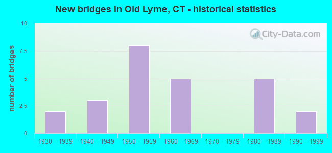
- New bridges - historical statistics
- 21930-1939
- 31940-1949
- 81950-1959
- 51960-1969
- 51980-1989
- 21990-1999
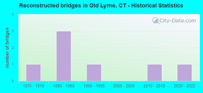
- Reconstructed bridges - Historical Statistics
- 11970-1979
- 31980-1989
- 11990-1999
- 02000-2009
- 12010-2019
- 12020-2022
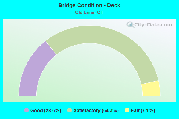
- Bridge Condition - Deck
- 28.6%Good
- 64.3%Satisfactory
- 7.1%Fair
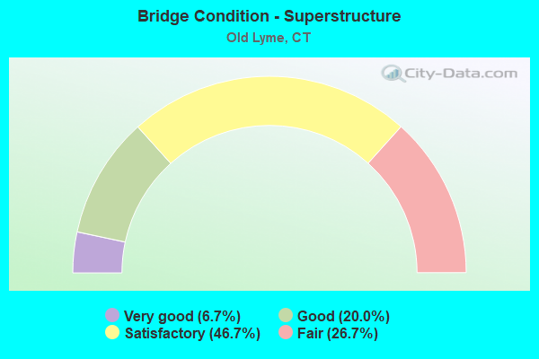
- Bridge Condition - Superstructure
- 6.7%Very good
- 20.0%Good
- 46.7%Satisfactory
- 26.7%Fair
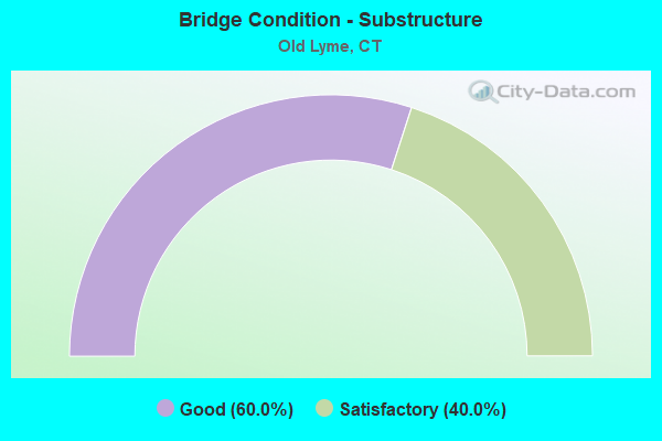
- Bridge Condition - Substructure
- 60.0%Good
- 40.0%Satisfactory
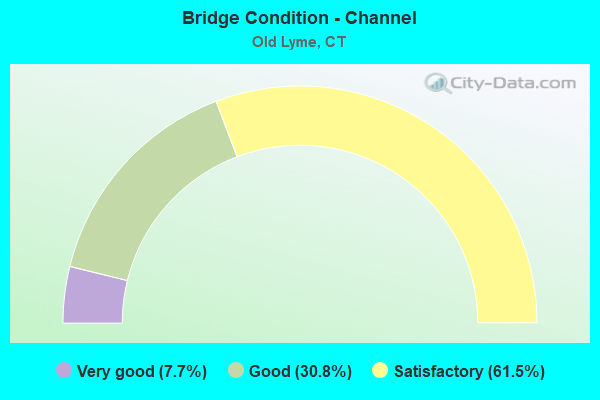
- Bridge Condition - Channel
- 7.7%Very good
- 30.8%Good
- 61.5%Satisfactory
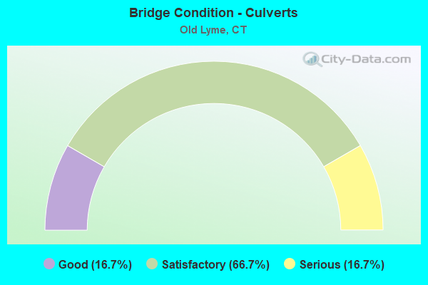
- Bridge Condition - Culverts
- 16.7%Good
- 66.7%Satisfactory
- 16.7%Serious
Find on map >> Show street view
Structure Number: 243, Location: 0.7 MI N OF US ROUTE 1 (Lat: 41.323583, Lng: -72.327536), Route carried "on" structure: Interstate 95, Year Built: 1948, Status: Open, Structure Length: 3.78m (12.40ft), Average Daily Traffic: 66,700 (year 2015), Truck Traffic: 10%, Average Future Daily Traffic: 99,110 (year 2035), Design Load: H 20, Features Intersected: LYME STREET
Minimum Vertical Clearance: 30+ m (98+ ft), Kilometerpoint: 128.426, Lanes on structure: 4, Lanes under structure: 2, Base Highway Network: Yes, Owner: State Highway Agency, Approaching Roadway Width: 20.7m (67.9ft), Skew: 31 degrees, Material/Design: Concrete continuous, Design/Construction: Arch - Deck, Number Of Spans In Main Unit: 3, Length of Maximum Span: 16.2m (53.1ft), Curb-To-Curb Width: 20.7m (67.9ft), Out-to-Out Width: 23.4m (76.8ft)
Condition: Superstructure: Satisfactory, Substructure: Satisfactory, Operating Rating: 89.8 metric tons, Method Used To Determine Operating Rating: Field evaluation and documented engineering judgment, Inventory Rating: 89.8 metric tons, Method Used To Determine Inventory Rating: Field evaluation and documented engineering judgment, Structural Evaluation: Equal to present minimum criteria, Deck Geometry: Equal to present minimum criteria, Underclear: Meets minimum limits, Approach Roadway Alignment: Equal to present desirable criteria, Designated Inspection Frequency: Every 24 months, Inspection Date: August 2020
Find on map >> Show street view
Structure Number: 244, Location: 2.0 MI N. OF ROUTE 156 (Lat: 41.318506, Lng: -72.301703), Route carried "on" structure: City street , Year Built: 1958, Status: Open, Structure Length: 6.07m (19.91ft), Average Daily Traffic: 1,060 (year 2021), Truck Traffic: 7%, Average Future Daily Traffic: 1,575 (year 2041), Design Load: H 20, Features Intersected: INTERSTATE-95, Facility Carried by Structure: WHIPPOORWILL ROAD
Minimum Vertical Clearance: 30+ m (98+ ft), Kilometerpoint: 1.770, Lanes on structure: 2, Lanes under structure: 4, Owner: State Highway Agency, Approaching Roadway Width: 12.2m (40.0ft), Skew: 4 degrees, Material/Design: Steel continuous, Design/Construction: Stringer/Multi-beam, Number Of Spans In Main Unit: 4, Length of Maximum Span: 18.7m (61.4ft), Curb or Sidewalk Widths: Left: 0.5m (1.6ft), Right: 0.5m (1.6ft), Curb-To-Curb Width: 12.2m (40.0ft), Out-to-Out Width: 13.9m (45.6ft)
Condition: Deck: Satisfactory, Superstructure: Satisfactory, Substructure: Satisfactory, Operating Rating: 63.0 metric tons, Method Used To Determine Operating Rating: Load Factor (LF), Inventory Rating: 37.9 metric tons, Method Used To Determine Inventory Rating: Load Factor (LF), Structural Evaluation: Equal to present minimum criteria, Deck Geometry: Better than present minimum criteria, Underclear: High priority of corrective action, Approach Roadway Alignment: Better than present minimum criteria, Designated Inspection Frequency: Every 24 months, Inspection Date: September 2021, Deck Structure Type: Concrete Cast-file-Place, Wearing Surface/Protective System: Wearing Surface: Bituminous, Membrane: Preformed Fabric
Find on map >> Show street view
Structure Number: 246, Location: 5.5 MI N OF ROUTE 9 (Lat: 41.322603, Lng: -72.259322), Route carried "on" structure: City street , Year Built: 1958, Year Reconstructed: 2015, Status: Open, Structure Length: 4.60m (15.09ft), Average Daily Traffic: 4,750 (year 2020), Truck Traffic: 2%, Average Future Daily Traffic: 7,058 (year 2040), Design Load: HS 20, Features Intersected: INTERSTATE-95, Facility Carried by Structure: FOUR MILE RIVER RD
Minimum Vertical Clearance: 30+ m (98+ ft), Kilometerpoint: 1.513, Lanes on structure: 2, Lanes under structure: 4, Owner: State Highway Agency, Approaching Roadway Width: 12.8m (42.0ft), Material/Design: Steel continuous, Design/Construction: Stringer/Multi-beam, Number Of Spans In Main Unit: 2, Length of Maximum Span: 22.2m (72.8ft), Curb-To-Curb Width: 12.8m (42.0ft), Out-to-Out Width: 13.9m (45.6ft)
Condition: Deck: Satisfactory, Superstructure: Satisfactory, Substructure: Satisfactory, Operating Rating: 66.1 metric tons, Method Used To Determine Operating Rating: Load Factor (LF), Inventory Rating: 39.7 metric tons, Method Used To Determine Inventory Rating: Load Factor (LF), Structural Evaluation: Equal to present minimum criteria, Deck Geometry: Equal to present minimum criteria, Underclear: High priority of corrective action, Approach Roadway Alignment: Equal to present desirable criteria, Designated Inspection Frequency: Every 24 months, Inspection Date: September 2020, Deck Structure Type: Concrete Cast-file-Place, Wearing Surface/Protective System: Wearing Surface: Bituminous, Membrane: Built-up
Find on map >> Show street view
Structure Number: 1013, Location: 0.5 MI N OF ROUTE 156 (Lat: 41.323772, Lng: -72.331253), Route carried "on" structure: US 1, Year Built: 1941, Year Reconstructed: 1995, Status: Open, Structure Length: 3.87m (12.70ft), Average Daily Traffic: 11,000 (year 2018), Truck Traffic: 5%, Average Future Daily Traffic: 16,345 (year 2038), Design Load: HS 20, Features Intersected: LIEUTENANT RIVER
Minimum Vertical Clearance: 30+ m (98+ ft), Kilometerpoint: 135.201, Lanes on structure: 2, Owner: State Highway Agency, Approaching Roadway Width: 11.0m (36.1ft), Material/Design: Prestressed concrete, Design/Construction: Box Beam or Girders - Multiple, Number Of Spans In Main Unit: 3, Length of Maximum Span: 14.9m (48.9ft), Curb or Sidewalk Widths: Left: 1.7m (5.6ft), Right: 0.0m, Curb-To-Curb Width: 10.9m (35.8ft), Out-to-Out Width: 13.6m (44.6ft)
Condition: Deck: Fair, Superstructure: Fair, Substructure: Good, Channel: Satisfactory, Operating Rating: 51.4 metric tons, Method Used To Determine Operating Rating: Load Factor (LF), Inventory Rating: 30.7 metric tons, Method Used To Determine Inventory Rating: Load Factor (LF), Structural Evaluation: Somewhat better than minimum adequacy, Deck Geometry: Meets minimum limits, Waterway Adequacy: Equal to present desirable criteria, Approach Roadway Alignment: Equal to present desirable criteria, Designated Inspection Frequency: Every 24 months, Underwater Inspection Frequency: Every 24 months, Inspection Date: March 2020, Underwater Inspection Date: March 2020, Deck Structure Type: Other, Wearing Surface/Protective System: Wearing Surface: Bituminous, Membrane: Built-up, Deck Protection: Epoxy Coated Reinforcing
Find on map >> Show street view
Structure Number: 1392, Location: 0.5 MI E OF I-95 (Lat: 41.313992, Lng: -72.337008), Route carried "on" structure: State highway 156, Year Built: 1961, Status: Open, Structure Length: 4.26m (13.98ft), Average Daily Traffic: 6,600 (year 2018), Truck Traffic: 3%, Average Future Daily Traffic: 9,807 (year 2038), Design Load: HS 20, Features Intersected: LIEUTENANT RIVER
Minimum Vertical Clearance: 30+ m (98+ ft), Kilometerpoint: 14.516, Lanes on structure: 2, Owner: State Highway Agency, Approaching Roadway Width: 12.2m (40.0ft), Skew: 3 degrees, Material/Design: Steel, Design/Construction: Stringer/Multi-beam, Number Of Spans In Main Unit: 2, Length of Maximum Span: 20.4m (66.9ft), Curb or Sidewalk Widths: Left: 1.5m (4.9ft), Right: 0.5m (1.6ft), Curb-To-Curb Width: 12.2m (40.0ft), Out-to-Out Width: 15.0m (49.2ft)
Condition: Deck: Satisfactory, Superstructure: Fair, Substructure: Satisfactory, Channel: Good, Operating Rating: 83.6 metric tons, Method Used To Determine Operating Rating: Load and Resistance Factor Rating (LRFR) rating reported by rating factor(RF) method using HL-93 loadings, Inventory Rating: 64.2 metric tons, Method Used To Determine Inventory Rating: Load and Resistance Factor Rating (LRFR) rating reported by rating factor(RF) method using HL-93 loadings, Structural Evaluation: Somewhat better than minimum adequacy, Deck Geometry: Somewhat better than minimum adequacy, Waterway Adequacy: Equal to present desirable criteria, Approach Roadway Alignment: Equal to present desirable criteria, Designated Inspection Frequency: Every 24 months, Inspection Date: July 2021, Deck Structure Type: Concrete Cast-file-Place, Wearing Surface/Protective System: Wearing Surface: Bituminous, Membrane: Preformed Fabric
Find on map >> Show street view
Structure Number: 1393, Location: 1.0 MI E OF US ROUTE 1 (Lat: 41.306414, Lng: -72.330108), Route carried "on" structure: State highway 156, Year Built: 1961, Year Reconstructed: 1988, Status: Open, Structure Length: 3.26m (10.70ft), Average Daily Traffic: 5,400 (year 2018), Truck Traffic: 3%, Average Future Daily Traffic: 8,024 (year 2038), Design Load: HS 20, Features Intersected: DUCK RIVER
Minimum Vertical Clearance: 30+ m (98+ ft), Kilometerpoint: 15.562, Lanes on structure: 2, Owner: State Highway Agency, Approaching Roadway Width: 12.8m (42.0ft), Skew: 3 degrees, Material/Design: Steel, Design/Construction: Stringer/Multi-beam, Number Of Spans In Main Unit: 1, Length of Maximum Span: 30.8m (101.0ft), Curb-To-Curb Width: 12.8m (42.0ft), Out-to-Out Width: 13.9m (45.6ft)
Condition: Deck: Satisfactory, Superstructure: Satisfactory, Substructure: Good, Channel: Good, Inventory Rating: 62.3 metric tons, Method Used To Determine Inventory Rating: Load Factor (LF), Structural Evaluation: Equal to present minimum criteria, Deck Geometry: Somewhat better than minimum adequacy, Waterway Adequacy: Equal to present desirable criteria, Approach Roadway Alignment: Better than present minimum criteria, Designated Inspection Frequency: Every 24 months, Inspection Date: May 2020, Deck Structure Type: Concrete Cast-file-Place, Wearing Surface/Protective System: Wearing Surface: Bituminous, Membrane: Preformed Fabric, Deck Protection: Epoxy Coated Reinforcing
Find on map >> Show street view
Structure Number: 1394, Location: 1.2 MI E OF I-95 (Lat: 41.304747, Lng: -72.329356), Route carried "on" structure: State highway 156, Year Built: 1961, Year Reconstructed: 1994, Status: Open, Structure Length: 7.99m (26.21ft), Average Daily Traffic: 5,400 (year 2018), Truck Traffic: 3%, Average Future Daily Traffic: 8,024 (year 2038), Design Load: HS 20, Features Intersected: AMTRAK RAILROAD
Minimum Vertical Clearance: 30+ m (98+ ft), Kilometerpoint: 15.739, Lanes on structure: 2, Owner: State Highway Agency, Approaching Roadway Width: 12.2m (40.0ft), Skew: 5 degrees, Material/Design: Steel continuous, Design/Construction: Stringer/Multi-beam, Number Of Spans In Main Unit: 3, Length of Maximum Span: 32.3m (106.0ft), Curb or Sidewalk Widths: Left: 0.5m (1.6ft), Right: 0.5m (1.6ft), Curb-To-Curb Width: 12.2m (40.0ft), Out-to-Out Width: 13.9m (45.6ft)
Condition: Deck: Satisfactory, Superstructure: Satisfactory, Substructure: Satisfactory, Operating Rating: 70.7 metric tons, Method Used To Determine Operating Rating: Load Factor (LF), Inventory Rating: 42.4 metric tons, Method Used To Determine Inventory Rating: Load Factor (LF), Structural Evaluation: Equal to present minimum criteria, Deck Geometry: Somewhat better than minimum adequacy, Underclear: High priority of corrective action, Approach Roadway Alignment: Equal to present desirable criteria, Designated Inspection Frequency: Every 24 months, Inspection Date: Febuary 2020, Deck Structure Type: Concrete Cast-file-Place, Wearing Surface/Protective System: Wearing Surface: Bituminous, Membrane: Preformed Fabric
Find on map >> Show street view
Structure Number: 1395, Location: 2.7 MI E OF I-95 (Lat: 41.289603, Lng: -72.312222), Route carried "on" structure: State highway 156, Year Built: 1936, Status: Open, Structure Length: 1.04m (3.41ft), Average Daily Traffic: 4,300 (year 2018), Truck Traffic: 6%, Average Future Daily Traffic: 6,389 (year 2038), Design Load: H 20, Features Intersected: BLACK HALL RIVER
Minimum Vertical Clearance: 30+ m (98+ ft), Kilometerpoint: 18.073, Lanes on structure: 2, Owner: State Highway Agency, Approaching Roadway Width: 9.1m (29.9ft), Material/Design: Concrete, Design/Construction: Tee Beam, Number Of Spans In Main Unit: 1, Length of Maximum Span: 9.1m (29.9ft), Curb-To-Curb Width: 9.1m (29.9ft), Out-to-Out Width: 10.7m (35.1ft)
Condition: Deck: Good, Superstructure: Good, Substructure: Satisfactory, Channel: Satisfactory, Operating Rating: 65.6 metric tons, Method Used To Determine Operating Rating: Load Factor (LF), Inventory Rating: 39.4 metric tons, Method Used To Determine Inventory Rating: Load Factor (LF), Structural Evaluation: Equal to present minimum criteria, Deck Geometry: Meets minimum limits, Waterway Adequacy: Equal to present minimum criteria, Approach Roadway Alignment: Equal to present desirable criteria, Designated Inspection Frequency: Every 24 months, Underwater Inspection Frequency: Every 24 months, Inspection Date: May 2020, Underwater Inspection Date: May 2020, Deck Structure Type: Concrete Cast-file-Place, Wearing Surface/Protective System: Wearing Surface: Bituminous, Membrane: Preformed Fabric
Find on map >> Show street view
Structure Number: 1396, Location: 5.4 MI E OF I-95 (Lat: 41.294267, Lng: -72.265325), Route carried "on" structure: State highway 156, Year Built: 1957, Status: Open, Structure Length: 3.60m (11.81ft), Average Daily Traffic: 2,600 (year 2017), Truck Traffic: 3%, Average Future Daily Traffic: 3,863 (year 2037), Design Load: HS 20, Features Intersected: AMTRAK RAILROAD
Minimum Vertical Clearance: 30+ m (98+ ft), Kilometerpoint: 22.434, Lanes on structure: 2, Owner: State Highway Agency, Approaching Roadway Width: 12.2m (40.0ft), Skew: 5 degrees, Material/Design: Steel, Design/Construction: Stringer/Multi-beam, Number Of Spans In Main Unit: 1, Length of Maximum Span: 33.2m (108.9ft), Curb-To-Curb Width: 12.2m (40.0ft), Out-to-Out Width: 13.9m (45.6ft)
Condition: Deck: Satisfactory, Superstructure: Good, Substructure: Good, Operating Rating: 84.4 metric tons, Method Used To Determine Operating Rating: Load Factor (LF), Inventory Rating: 50.6 metric tons, Method Used To Determine Inventory Rating: Load Factor (LF), Structural Evaluation: Better than present minimum criteria, Deck Geometry: Equal to present minimum criteria, Underclear: High priority of corrective action, Approach Roadway Alignment: Equal to present minimum criteria, Designated Inspection Frequency: Every 24 months, Inspection Date: Febuary 2020, Deck Structure Type: Concrete Cast-file-Place, Wearing Surface/Protective System: Wearing Surface: Bituminous, Membrane: Preformed Fabric
Find on map >> Show street view
Structure Number: 2713, Location: E.LYME/OLD LYME TOWN LINE (Lat: 41.309850, Lng: -72.254089), Route carried "on" structure: State highway 156, Year Built: 1982, Status: Open, Structure Length: 0.85m (2.79ft), Average Daily Traffic: 2,600 (year 2015), Truck Traffic: 5%, Average Future Daily Traffic: 3,863 (year 2035), Design Load: HS 20, Features Intersected: FOUR MILE RIVER
Minimum Vertical Clearance: 30+ m (98+ ft), Kilometerpoint: 24.752, Lanes on structure: 2, Owner: State Highway Agency, Approaching Roadway Width: 9.8m (32.2ft), Material/Design: Steel, Design/Construction: Culvert, Number Of Spans In Main Unit: 4, Length of Maximum Span: 1.5m (4.9ft)
Condition: Channel: Satisfactory, Culverts: Serious, Operating Rating: 52.6 metric tons, Method Used To Determine Operating Rating: Field evaluation and documented engineering judgment, Inventory Rating: 30.8 metric tons, Method Used To Determine Inventory Rating: Field evaluation and documented engineering judgment, Structural Evaluation: High priority of corrective action, Waterway Adequacy: Better than present minimum criteria, Approach Roadway Alignment: Equal to present desirable criteria, Designated Inspection Frequency: Every 24 months, Inspection Date: May 2020, Total Project Cost: $550,000 ( Estimate for 2017)
Find on map >> Show street view
Structure Number: 3136, Location: 500-FT SO. OF SMITH ST BR (Lat: 41.582658, Lng: -72.714619), Route carried "on" structure: Interstate 91, Year Built: 1965, Status: Open, Structure Length: 0.70m (2.30ft), Average Daily Traffic: 108,700 (year 2019), Truck Traffic: 9%, Average Future Daily Traffic: 161,517 (year 2039), Features Intersected: FALLS BROOK
Minimum Vertical Clearance: 30+ m (98+ ft), Kilometerpoint: 38.850, Lanes on structure: 6, Base Highway Network: Yes, Owner: State Highway Agency, Approaching Roadway Width: 30.5m (100.1ft), Skew: 4 degrees, Material/Design: Concrete continuous, Design/Construction: Culvert, Number Of Spans In Main Unit: 2, Length of Maximum Span: 3.4m (11.2ft)
Condition: Channel: Good, Culverts: Good, Structural Evaluation: Better than present minimum criteria, Waterway Adequacy: Equal to present desirable criteria, Approach Roadway Alignment: Equal to present desirable criteria, Designated Inspection Frequency: Every 48 months, Inspection Date: December 2021
Find on map >> Show street view
Structure Number: 3138, Location: 0.7 MI WEST OF I91 (Lat: 41.424453, Lng: -72.826031), Route carried "on" structure: Ramp State highway 702, Year Built: 1965, Status: Open, Structure Length: 1.86m (6.10ft), Average Daily Traffic: 7,900 (year 2019), Truck Traffic: 6%, Average Future Daily Traffic: 11,739 (year 2039), Design Load: HS 20, Features Intersected: POND HILL ROAD
Minimum Vertical Clearance: 30+ m (98+ ft), Kilometerpoint: 1.062, Lanes on structure: 2, Lanes under structure: 2, Owner: State Highway Agency, Approaching Roadway Width: 7.9m (25.9ft), Skew: 21 degrees, Material/Design: Steel, Design/Construction: Stringer/Multi-beam, Number Of Spans In Main Unit: 1, Length of Maximum Span: 16.5m (54.1ft), Curb-To-Curb Width: 17.5m (57.4ft), Out-to-Out Width: 18.5m (60.7ft)
Condition: Deck: Satisfactory, Superstructure: Satisfactory, Substructure: Good, Operating Rating: 57.7 metric tons, Method Used To Determine Operating Rating: Load and Resistance Factor Rating (LRFR) rating reported by rating factor(RF) method using HL-93 loadings, Inventory Rating: 44.4 metric tons, Method Used To Determine Inventory Rating: Load and Resistance Factor Rating (LRFR) rating reported by rating factor(RF) method using HL-93 loadings, Structural Evaluation: Equal to present minimum criteria, Deck Geometry: Superior to present desirable criteria, Underclear: Meets minimum limits, Approach Roadway Alignment: Equal to present desirable criteria, Designated Inspection Frequency: Every 24 months, Inspection Date: December 2021, Deck Structure Type: Concrete Cast-file-Place, Wearing Surface/Protective System: Wearing Surface: Monolithic Concrete
Find on map >> Show street view
Structure Number: 3217, Location: 0.7 MI S OF ROUTE 110 (Lat: 41.305908, Lng: -73.098775), Route carried "on" structure: State highway 8, Year Built: 1950, Status: Open, Structure Length: 0.82m (2.69ft), Average Daily Traffic: 66,000 (year 2018), Truck Traffic: 5%, Average Future Daily Traffic: 98,069 (year 2038), Design Load: HS 20, Features Intersected: STREAMING GROUND BROOK
Minimum Vertical Clearance: 30+ m (98+ ft), Kilometerpoint: 18.588, Lanes on structure: 6, Base Highway Network: Yes, Owner: State Highway Agency, Approaching Roadway Width: 25.6m (84.0ft), Skew: 26 degrees, Material/Design: Concrete, Design/Construction: Culvert, Number Of Spans In Main Unit: 1, Length of Maximum Span: 8.2m (26.9ft)
Condition: Channel: Satisfactory, Culverts: Satisfactory, Operating Rating: 57.7 metric tons, Method Used To Determine Operating Rating: Load and Resistance Factor Rating (LRFR) rating reported by rating factor(RF) method using HL-93 loadings, Inventory Rating: 44.4 metric tons, Method Used To Determine Inventory Rating: Load and Resistance Factor Rating (LRFR) rating reported by rating factor(RF) method using HL-93 loadings, Structural Evaluation: Equal to present minimum criteria, Waterway Adequacy: Equal to present minimum criteria, Approach Roadway Alignment: Equal to present desirable criteria, Designated Inspection Frequency: Every 24 months, Inspection Date: June 2021
Find on map >> Show street view
Structure Number: 4346, Location: 0.8 MI N OF ROUTE 156 (Lat: 41.296814, Lng: -72.304917), Route carried "on" structure: City street , Year Built: 1933, Year Reconstructed: 1981, Status: Open, Structure Length: 1.04m (3.41ft), Average Daily Traffic: 412 (year 2017), Truck Traffic: 7%, Average Future Daily Traffic: 612 (year 2037), Design Load: HS 20, Features Intersected: AMTRAK RAILROAD, Facility Carried by Structure: BUTTON BALL ROAD
Minimum Vertical Clearance: 30+ m (98+ ft), Kilometerpoint: 1.577, Lanes on structure: 2, Maintenance Responsibility: Local Agency, Approaching Roadway Width: 6.7m (22.0ft), Material/Design: Prestressed concrete, Design/Construction: Slab, Number Of Spans In Main Unit: 1, Length of Maximum Span: 9.4m (30.8ft), Curb or Sidewalk Widths: Left: 0.2m (0.7ft), Right: 0.2m (0.7ft), Curb-To-Curb Width: 6.8m (22.3ft), Out-to-Out Width: 7.6m (24.9ft)
Condition: Deck: Satisfactory, Superstructure: Good, Substructure: Good, Operating Rating: 71.7 metric tons, Method Used To Determine Operating Rating: Load Factor (LF), Inventory Rating: 43.0 metric tons, Method Used To Determine Inventory Rating: Load Factor (LF), Structural Evaluation: Better than present minimum criteria, Deck Geometry: Meets minimum limits, Underclear: High priority of corrective action, Approach Roadway Alignment: High priority of corrective action, Designated Inspection Frequency: Every 48 months, Inspection Date: Febuary 2018, Deck Structure Type: Other, Wearing Surface/Protective System: Wearing Surface: Bituminous, Membrane: Built-up
Find on map >> Show street view
Structure Number: 4738, Location: 0.2 MILE N OF US ROUTE 1 (Lat: 41.350278, Lng: -72.302567), Route carried "on" structure: City street , Year Built: 1982, Status: Open, Structure Length: 1.77m (5.81ft), Average Daily Traffic: 2,121 (year 2020), Truck Traffic: 10%, Average Future Daily Traffic: 3,152 (year 2040), Design Load: HS 20, Features Intersected: MILL BROOK, Facility Carried by Structure: TOWN WOODS ROAD
Minimum Vertical Clearance: 30+ m (98+ ft), Kilometerpoint: 0.338, Lanes on structure: 2, Owner: Town or Township Highway Agency, Approaching Roadway Width: 7.0m (23.0ft), Material/Design: Concrete, Design/Construction: Culvert, Number Of Spans In Main Unit: 3, Length of Maximum Span: 5.5m (18.0ft), Curb or Sidewalk Widths: Left: 1.4m (4.6ft), Right: 1.7m (5.6ft), Curb-To-Curb Width: 8.5m (27.9ft), Out-to-Out Width: 14.0m (45.9ft)
Condition: Channel: Very good, Culverts: Satisfactory, Operating Rating: 42.6 metric tons, Method Used To Determine Operating Rating: Field evaluation and documented engineering judgment, Inventory Rating: 32.7 metric tons, Method Used To Determine Inventory Rating: Field evaluation and documented engineering judgment, Structural Evaluation: Equal to present minimum criteria, Deck Geometry: Meets minimum limits, Waterway Adequacy: Equal to present desirable criteria, Approach Roadway Alignment: Equal to present desirable criteria, Designated Inspection Frequency: Every 24 months, Inspection Date: April 2020, Deck Structure Type: Other, Wearing Surface/Protective System: Wearing Surface: Bituminous
Find on map >> Show street view
Structure Number: 4739, Location: 0.4 MI N OF US ROUTE 1 (Lat: 41.335339, Lng: -72.323872), Route carried "on" structure: City street , Year Built: 1982, Status: Open, Structure Length: 1.77m (5.81ft), Average Daily Traffic: 1,173 (year 2020), Truck Traffic: 10%, Average Future Daily Traffic: 1,743 (year 2040), Design Load: HS 20, Features Intersected: MILL BROOK, Facility Carried by Structure: SILL LANE #1
Minimum Vertical Clearance: 30+ m (98+ ft), Kilometerpoint: 0.676, Lanes on structure: 2, Owner: Town or Township Highway Agency, Approaching Roadway Width: 6.1m (20.0ft), Material/Design: Concrete, Design/Construction: Culvert, Number Of Spans In Main Unit: 3, Length of Maximum Span: 5.5m (18.0ft), Curb or Sidewalk Widths: Left: 1.1m (3.6ft), Right: 1.4m (4.6ft), Curb-To-Curb Width: 6.1m (20.0ft), Out-to-Out Width: 9.3m (30.5ft)
Condition: Channel: Satisfactory, Culverts: Satisfactory, Operating Rating: 42.6 metric tons, Method Used To Determine Operating Rating: Field evaluation and documented engineering judgment, Inventory Rating: 32.7 metric tons, Method Used To Determine Inventory Rating: Field evaluation and documented engineering judgment, Structural Evaluation: Equal to present minimum criteria, Deck Geometry: High priority of replacement, Waterway Adequacy: Equal to present desirable criteria, Approach Roadway Alignment: Equal to present desirable criteria, Designated Inspection Frequency: Every 24 months, Inspection Date: April 2020, Deck Structure Type: Other, Wearing Surface/Protective System: Wearing Surface: Bituminous
Find on map >> Show street view
Structure Number: 4747, Location: 1 MI E. OF ROUTE 156 (Lat: 41.305000, Lng: -72.307528), Route carried "on" structure: City street , Year Built: 1955, Year Reconstructed: 2020, Status: Open, Structure Length: 1.36m (4.46ft), Average Daily Traffic: 2,162 (year 2020), Truck Traffic: 10%, Average Future Daily Traffic: 3,213 (year 2040), Design Load: HL 93, Features Intersected: BLACKHALL RIVER, Facility Carried by Structure: MILE CREEK ROAD
Minimum Vertical Clearance: 30+ m (98+ ft), Kilometerpoint: 1.593, Lanes on structure: 2, Owner: Town or Township Highway Agency, Approaching Roadway Width: 8.2m (26.9ft), Material/Design: Steel, Design/Construction: Stringer/Multi-beam, Number Of Spans In Main Unit: 1, Length of Maximum Span: 12.3m (40.4ft), Curb-To-Curb Width: 9.1m (29.9ft), Out-to-Out Width: 10.1m (33.1ft)
Condition: Deck: Good, Superstructure: Very good, Substructure: Good, Channel: Satisfactory, Operating Rating: 48.9 metric tons, Method Used To Determine Operating Rating: Load and Resistance Factor Rating (LRFR) rating reported by rating factor(RF) method using HL-93 loadings, Inventory Rating: 37.6 metric tons, Method Used To Determine Inventory Rating: Load and Resistance Factor Rating (LRFR) rating reported by rating factor(RF) method using HL-93 loadings, Structural Evaluation: Better than present minimum criteria, Deck Geometry: Meets minimum limits, Approach Roadway Alignment: Equal to present minimum criteria, Designated Inspection Frequency: Every 24 months, Inspection Date: October 2020, Total Project Cost: $759,000 ( Estimate for 2018), Deck Structure Type: Concrete Precast Panels, Wearing Surface/Protective System: Wearing Surface: Epoxy Overlay, Deck Protection: Galvanized Reinforcing
Find on map >> Show street view
Structure Number: 4818, Location: 0.2 MI W OF US ROUTE 1 (Lat: 41.342783, Lng: -72.311561), Route carried "on" structure: City street , Year Built: 1982, Status: Open, Structure Length: 1.77m (5.81ft), Average Daily Traffic: 375 (year 2020), Truck Traffic: 10%, Average Future Daily Traffic: 557 (year 2040), Design Load: HS 20, Features Intersected: MILL BROOK, Facility Carried by Structure: SILL LANE #2
Minimum Vertical Clearance: 30+ m (98+ ft), Kilometerpoint: 0.982, Lanes on structure: 2, Owner: Town or Township Highway Agency, Approaching Roadway Width: 6.4m (21.0ft), Material/Design: Concrete, Design/Construction: Culvert, Number Of Spans In Main Unit: 3, Length of Maximum Span: 5.5m (18.0ft), Curb or Sidewalk Widths: Left: 1.2m (3.9ft), Right: 1.2m (3.9ft), Curb-To-Curb Width: 6.3m (20.7ft), Out-to-Out Width: 9.4m (30.8ft)
Condition: Channel: Satisfactory, Culverts: Satisfactory, Operating Rating: 42.6 metric tons, Method Used To Determine Operating Rating: Field evaluation and documented engineering judgment, Inventory Rating: 32.7 metric tons, Method Used To Determine Inventory Rating: Field evaluation and documented engineering judgment, Structural Evaluation: Equal to present minimum criteria, Deck Geometry: Meets minimum limits, Waterway Adequacy: Equal to present desirable criteria, Approach Roadway Alignment: Equal to present desirable criteria, Designated Inspection Frequency: Every 24 months, Inspection Date: April 2020, Deck Structure Type: Other, Wearing Surface/Protective System: Wearing Surface: Bituminous
Find on map >> Show street view
Structure Number: 5972, Location: 0.3 MI N OF NORTH MAIN ST (Lat: 41.799897, Lng: -72.528769), Route carried "on" structure: City street , Year Built: 1989, Status: Open, Structure Length: 5.94m (19.49ft), Average Daily Traffic: 5,200 (year 2018), Truck Traffic: 4%, Average Future Daily Traffic: 7,727 (year 2038), Design Load: HS 20, Features Intersected: HOCKANUM RIVER, Facility Carried by Structure: UNION STREET
Minimum Vertical Clearance: 30+ m (98+ ft), Kilometerpoint: 68.880, Lanes on structure: 2, Owner: Town or Township Highway Agency, Approaching Roadway Width: 10.4m (34.1ft), Material/Design: Prestressed concrete continuous, Design/Construction: Stringer/Multi-beam, Number Of Spans In Main Unit: 2, Length of Maximum Span: 29.0m (95.1ft), Curb or Sidewalk Widths: Left: 0.0m, Right: 2.0m (6.6ft), Curb-To-Curb Width: 10.4m (34.1ft), Out-to-Out Width: 13.3m (43.6ft)
Condition: Deck: Good, Superstructure: Fair, Substructure: Good, Channel: Satisfactory, Operating Rating: 36.6 metric tons, Method Used To Determine Operating Rating: Load and Resistance Factor Rating (LRFR) rating reported by rating factor(RF) method using HL-93 loadings, Inventory Rating: 28.2 metric tons, Method Used To Determine Inventory Rating: Load and Resistance Factor Rating (LRFR) rating reported by rating factor(RF) method using HL-93 loadings, Structural Evaluation: Somewhat better than minimum adequacy, Deck Geometry: Meets minimum limits, Waterway Adequacy: Equal to present desirable criteria, Approach Roadway Alignment: Better than present minimum criteria, Designated Inspection Frequency: Every 24 months, Inspection Date: Febuary 2021, Deck Structure Type: Concrete Cast-file-Place, Wearing Surface/Protective System: Wearing Surface: Bituminous, Membrane: Preformed Fabric, Deck Protection: Epoxy Coated Reinforcing
Find on map >> Show street view
Structure Number: 6032, Location: 0.4 MI N OF US ROUTE 1 (Lat: 41.323292, Lng: -72.331328), Route carried "on" structure: Interstate 95, Year Built: 1948, Year Reconstructed: 1991, Status: Open, Structure Length: 5.85m (19.19ft), Average Daily Traffic: 67,400 (year 2017), Truck Traffic: 14%, Average Future Daily Traffic: 100,150 (year 2037), Design Load: HS 20, Features Intersected: LIEUTENANT RIVER
Minimum Vertical Clearance: 30+ m (98+ ft), Kilometerpoint: 128.088, Lanes on structure: 4, Base Highway Network: Yes, Owner: State Highway Agency, Approaching Roadway Width: 21.3m (69.9ft), Skew: 33 degrees, Material/Design: Steel continuous, Design/Construction: Stringer/Multi-beam, Number Of Spans In Main Unit: 3, Length of Maximum Span: 21.6m (70.9ft), Curb-To-Curb Width: 21.4m (70.2ft), Out-to-Out Width: 23.5m (77.1ft)
Condition: Deck: Satisfactory, Superstructure: Fair, Substructure: Good, Channel: Good, Operating Rating: 47.0 metric tons, Method Used To Determine Operating Rating: Load and Resistance Factor Rating (LRFR) rating reported by rating factor(RF) method using HL-93 loadings, Inventory Rating: 36.3 metric tons, Method Used To Determine Inventory Rating: Load and Resistance Factor Rating (LRFR) rating reported by rating factor(RF) method using HL-93 loadings, Structural Evaluation: Somewhat better than minimum adequacy, Deck Geometry: Better than present minimum criteria, Waterway Adequacy: Superior to present desirable criteria, Approach Roadway Alignment: Equal to present desirable criteria, Designated Inspection Frequency: Every 24 months, Underwater Inspection Frequency: Every 48 months, Inspection Date: January 2020, Underwater Inspection Date: Febuary 2020, Deck Structure Type: Concrete Cast-file-Place, Wearing Surface/Protective System: Wearing Surface: Bituminous, Membrane: Built-up, Deck Protection: Other
Find on map >> Show street view
Structure Number: 6173, Location: 1.0 MI N OF ROUTE 9 (Lat: 41.320514, Lng: -72.339244), Route carried "on" structure: Interstate 95, Year Built: 1992, Status: Open, Structure Length: 3.78m (12.40ft), Average Daily Traffic: 67,400 (year 2017), Truck Traffic: 9%, Average Future Daily Traffic: 100,150 (year 2037), Design Load: HS 20, Features Intersected: ROUTE 156
Minimum Vertical Clearance: 30+ m (98+ ft), Kilometerpoint: 127.380, Lanes on structure: 6, Lanes under structure: 4, Base Highway Network: Yes, Owner: State Highway Agency, Approaching Roadway Width: 36.6m (120.1ft), Skew: 30 degrees, Material/Design: Steel, Design/Construction: Stringer/Multi-beam, Number Of Spans In Main Unit: 1, Length of Maximum Span: 36.0m (118.1ft), Curb-To-Curb Width: 36.6m (120.1ft), Out-to-Out Width: 39.6m (129.9ft)
Condition: Deck: Good, Superstructure: Satisfactory, Substructure: Good, Operating Rating: 43.4 metric tons, Method Used To Determine Operating Rating: Load and Resistance Factor Rating (LRFR) rating reported by rating factor(RF) method using HL-93 loadings, Inventory Rating: 33.4 metric tons, Method Used To Determine Inventory Rating: Load and Resistance Factor Rating (LRFR) rating reported by rating factor(RF) method using HL-93 loadings, Structural Evaluation: Equal to present minimum criteria, Deck Geometry: Superior to present desirable criteria, Underclear: Better than present minimum criteria, Approach Roadway Alignment: Equal to present desirable criteria, Designated Inspection Frequency: Every 24 months, Inspection Date: March 2020, Deck Structure Type: Concrete Cast-file-Place, Wearing Surface/Protective System: Wearing Surface: Bituminous, Membrane: Preformed Fabric, Deck Protection: Epoxy Coated Reinforcing
Find on map >> Show street view
Structure Number: 244, Location: 2.0 MI N. OF ROUTE 156 (Lat: 41.318506, Lng: -72.301703), Route carried "under" structure: Interstate 95, Year Built: 1958, Structure Length: 0. m, Average Daily Traffic: 61,900 (year 2020), Truck Traffic: 14%, Features Intersected: INTERSTATE-95, Facility Carried by Structure: WHIPPOORWILL ROAD
Minimum Vertical Clearance: 4.65m (15.26ft), Kilometerpoint: 130.679, Lanes on structure: 2, Lanes under structure: 4, Material/Design: Steel continuous, Design/Construction: Stringer/Multi-beam, Length of Maximum Span: 18.7m (61.4ft)
Find on map >> Show street view
Structure Number: 245, Location: 3.1 MI N OF US ROUTE 1 (Lat: 41.317364, Lng: -72.281472), Route carried "under" structure: Interstate 95, Year Built: 1958, Structure Length: 0. m, Average Daily Traffic: 61,900 (year 2020), Truck Traffic: 14%, Features Intersected: INTERSTATE-95, Facility Carried by Structure: FLAT ROCK HILL RD
Minimum Vertical Clearance: 5.11m (16.77ft), Kilometerpoint: 132.417, Lanes on structure: 2, Lanes under structure: 4, Material/Design: Steel continuous, Design/Construction: Stringer/Multi-beam, Length of Maximum Span: 26.5m (86.9ft)
Find on map >> Show street view
Structure Number: 246, Location: 5.5 MI N OF ROUTE 9 (Lat: 41.322603, Lng: -72.259322), Route carried "under" structure: Interstate 95, Year Built: 1958, Structure Length: 0. m, Average Daily Traffic: 69,800 (year 2017), Truck Traffic: 14%, Features Intersected: INTERSTATE-95, Facility Carried by Structure: FOUR MILE RIVER RD
Minimum Vertical Clearance: 5.13m (16.83ft), Kilometerpoint: 134.364, Lanes on structure: 2, Lanes under structure: 4, Material/Design: Steel continuous, Design/Construction: Stringer/Multi-beam, Length of Maximum Span: 22.2m (72.8ft)
Find on map >> Show street view
Structure Number: 6173, Location: 1.0 MI N OF ROUTE 9 (Lat: 41.320514, Lng: -72.339244), Route carried "under" structure: State highway 156, Year Built: 1992, Structure Length: 0. m, Average Daily Traffic: 8,900 (year 2018), Truck Traffic: 5%, Features Intersected: ROUTE 156, Facility Carried by Structure: INTERSTATE-95
Minimum Vertical Clearance: 5.59m (18.34ft), Kilometerpoint: 13.744, Lanes on structure: 6, Lanes under structure: 4, Material/Design: Steel, Design/Construction: Stringer/Multi-beam, Length of Maximum Span: 36.0m (118.1ft)