Bridge Statistics for Omaha, Illinois (IL)
Condition, Traffic, Stress, Structural Evaluation, Project Costs
- National Bridge Inventory (NBI) Statistics
- 16Number of bridges
- 177ft / 53.8mTotal length
- $162,000Total costs
- 8,920Total average daily traffic
- 1,754Total average daily truck traffic
- 28,963Total future (year 2032) average daily traffic
- National Bridge Inventory (NBI) Registered Bridges for Omaha
- No street view available for this location
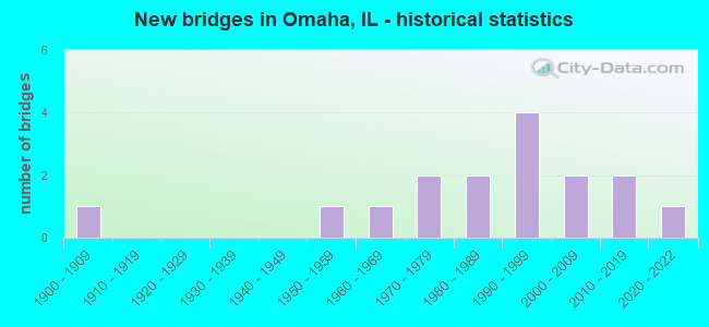
- New bridges - historical statistics
- 11900-1909
- 11950-1959
- 11960-1969
- 21970-1979
- 21980-1989
- 41990-1999
- 22000-2009
- 22010-2019
- 12020-2022
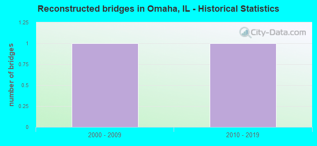
- Reconstructed bridges - Historical Statistics
- 12000-2009
- 12010-2019
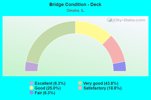
- Bridge Condition - Deck
- 6.3%Excellent
- 43.8%Very good
- 25.0%Good
- 18.8%Satisfactory
- 6.3%Fair
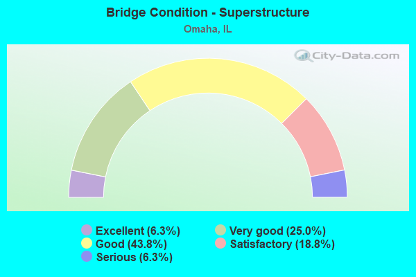
- Bridge Condition - Superstructure
- 6.3%Excellent
- 25.0%Very good
- 43.8%Good
- 18.8%Satisfactory
- 6.3%Serious
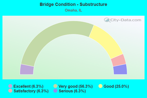
- Bridge Condition - Substructure
- 6.3%Excellent
- 56.3%Very good
- 25.0%Good
- 6.3%Satisfactory
- 6.3%Serious
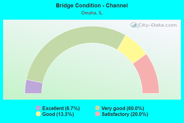
- Bridge Condition - Channel
- 6.7%Excellent
- 60.0%Very good
- 13.3%Good
- 20.0%Satisfactory
Find on map >> Show street view
Structure Number: 300018, Location: 1 MI. SOUTH OF OMAHA (Lat: 37.882886, Lng: -88.298503), Route carried "on" structure: State highway 1, Year Built: 1978, Year Reconstructed: 2009, Status: Open, Structure Length: 4.91m (16.11ft), Average Daily Traffic: 1,200 (year 2021), Truck Traffic: 33%, Average Future Daily Traffic: 1,284 (year 2032), Design Load: HS 20, Features Intersected: CANE CREEK
Minimum Vertical Clearance: 30+ m (98+ ft), Kilometerpoint: 50.661, Lanes on structure: 2, Base Highway Network: Yes, Owner: State Highway Agency, Approaching Roadway Width: 9.4m (30.8ft), Skew: 1 degrees, Material/Design: Prestressed concrete, Design/Construction: Box Beam or Girders - Multiple, Number Of Spans In Main Unit: 3, Length of Maximum Span: 16.1m (52.8ft), Curb-To-Curb Width: 10.1m (33.1ft), Out-to-Out Width: 10.1m (33.1ft)
Condition: Deck: Good, Superstructure: Very good, Substructure: Good, Channel: Satisfactory, Operating Rating: 61.9 metric tons, Method Used To Determine Operating Rating: Load Factor (LF) rating reported by rating factor (RF) method using MS18 loading, Inventory Rating: 40.8 metric tons, Method Used To Determine Inventory Rating: Load Factor (LF) rating reported by rating factor (RF) method using MS18 loading, Structural Evaluation: Better than present minimum criteria, Deck Geometry: Somewhat better than minimum adequacy, Waterway Adequacy: Equal to present minimum criteria, Approach Roadway Alignment: Equal to present desirable criteria, Designated Inspection Frequency: Every 48 months, Inspection Date: July 2019, Deck Structure Type: Concrete Precast Panels, Wearing Surface/Protective System: Wearing Surface: Integral Concrete, Deck Protection: Epoxy Coated Reinforcing
Find on map >> Show street view
Structure Number: 303065, Location: 1 MI S. OF OMAHA (Lat: 37.868161, Lng: -88.316389), Route carried "on" structure: County highway , Year Built: 1977, Status: Open, Structure Length: 5.15m (16.90ft), Average Daily Traffic: 50 (year 2018), Truck Traffic: 66%, Average Future Daily Traffic: 103 (year 2032), Design Load: HS 20, Features Intersected: CANE CREEK, Facility Carried by Structure: CH 1
Minimum Vertical Clearance: 30+ m (98+ ft), Kilometerpoint: 4.731, Lanes on structure: 2, Owner: County Highway Agency, Approaching Roadway Width: 8.5m (27.9ft), Material/Design: Prestressed concrete, Design/Construction: Box Beam or Girders - Multiple, Number Of Spans In Main Unit: 3, Length of Maximum Span: 17.1m (56.1ft), Curb-To-Curb Width: 7.7m (25.3ft), Out-to-Out Width: 8.4m (27.6ft)
Condition: Deck: Very good, Superstructure: Good, Substructure: Good, Channel: Satisfactory, Operating Rating: 44.4 metric tons, Method Used To Determine Operating Rating: Assigned rating based on Load Factor Design (LFD) reported by rating factor (RF) using MS18 loading, Inventory Rating: 32.4 metric tons, Method Used To Determine Inventory Rating: Assigned rating based on Load Factor Design (LFD) reported by rating factor (RF) using MS18 loading, Structural Evaluation: Better than present minimum criteria, Deck Geometry: Equal to present minimum criteria, Waterway Adequacy: Somewhat better than minimum adequacy, Approach Roadway Alignment: Equal to present desirable criteria, Designated Inspection Frequency: Every 48 months, Inspection Date: November 2021, Deck Structure Type: Concrete Precast Panels
Find on map >> Show street view
Structure Number: 303075, Location: 5 MILE SE OF OMAHA (Lat: 37.874111, Lng: -88.251894), Route carried "on" structure: County highway , Year Built: 1982, Status: Open, Structure Length: 1.98m (6.50ft), Average Daily Traffic: 50 (year 2018), Truck Traffic: 62%, Average Future Daily Traffic: 26 (year 2032), Design Load: HS 20, Features Intersected: CANE CREEK, Facility Carried by Structure: TR 126
Minimum Vertical Clearance: 30+ m (98+ ft), Kilometerpoint: 2.237, Lanes on structure: 2, Owner: Town or Township Highway Agency, Approaching Roadway Width: 6.1m (20.0ft), Material/Design: Prestressed concrete, Design/Construction: Box Beam or Girders - Multiple, Number Of Spans In Main Unit: 1, Length of Maximum Span: 18.9m (62.0ft), Curb-To-Curb Width: 7.8m (25.6ft), Out-to-Out Width: 8.4m (27.6ft)
Condition: Deck: Good, Superstructure: Good, Substructure: Satisfactory, Channel: Good, Operating Rating: 44.4 metric tons, Method Used To Determine Operating Rating: Assigned rating based on Load Factor Design (LFD) reported by rating factor (RF) using MS18 loading, Inventory Rating: 32.4 metric tons, Method Used To Determine Inventory Rating: Assigned rating based on Load Factor Design (LFD) reported by rating factor (RF) using MS18 loading, Structural Evaluation: Equal to present minimum criteria, Deck Geometry: Equal to present minimum criteria, Waterway Adequacy: Equal to present desirable criteria, Approach Roadway Alignment: Equal to present desirable criteria, Designated Inspection Frequency: Every 24 months, Inspection Date: October 2020, Deck Structure Type: Concrete Precast Panels
Find on map >> Show street view
Structure Number: 303076, Location: EAST EDGE OF OMAHA (Lat: 37.886642, Lng: -88.297678), Route carried "on" structure: County highway , Year Built: 1982, Status: Open, Structure Length: 1.89m (6.20ft), Average Daily Traffic: 25 (year 2018), Truck Traffic: 36%, Average Future Daily Traffic: 51 (year 2032), Design Load: HS 20, Features Intersected: CANE CREEK, Facility Carried by Structure: TR 23
Minimum Vertical Clearance: 30+ m (98+ ft), Kilometerpoint: 0.016, Lanes on structure: 2, Owner: Town or Township Highway Agency, Approaching Roadway Width: 6.1m (20.0ft), Skew: 2 degrees, Material/Design: Prestressed concrete, Design/Construction: Box Beam or Girders - Multiple, Number Of Spans In Main Unit: 1, Length of Maximum Span: 17.7m (58.1ft), Curb-To-Curb Width: 7.8m (25.6ft), Out-to-Out Width: 8.4m (27.6ft)
Condition: Deck: Very good, Superstructure: Good, Substructure: Very good, Channel: Very good, Operating Rating: 44.4 metric tons, Method Used To Determine Operating Rating: Assigned rating based on Load Factor Design (LFD) reported by rating factor (RF) using MS18 loading, Inventory Rating: 32.4 metric tons, Method Used To Determine Inventory Rating: Assigned rating based on Load Factor Design (LFD) reported by rating factor (RF) using MS18 loading, Structural Evaluation: Better than present minimum criteria, Deck Geometry: Equal to present minimum criteria, Waterway Adequacy: Equal to present desirable criteria, Approach Roadway Alignment: Equal to present desirable criteria, Designated Inspection Frequency: Every 48 months, Inspection Date: November 2018, Deck Structure Type: Concrete Precast Panels
Find on map >> Show street view
Structure Number: 303094, Location: 0.04 MI NE OMAHA (Lat: 37.894019, Lng: -88.300536), Route carried "on" structure: County highway , Year Built: 1991, Status: Open, Structure Length: 1.99m (6.53ft), Average Daily Traffic: 50 (year 2018), Truck Traffic: 14%, Average Future Daily Traffic: 77 (year 2032), Design Load: HS 20, Features Intersected: CANE CREEK, Facility Carried by Structure: TR 15
Minimum Vertical Clearance: 30+ m (98+ ft), Kilometerpoint: 0.097, Lanes on structure: 2, Owner: Town or Township Highway Agency, Approaching Roadway Width: 5.5m (18.0ft), Material/Design: Prestressed concrete, Design/Construction: Box Beam or Girders - Multiple, Number Of Spans In Main Unit: 1, Length of Maximum Span: 19.1m (62.7ft), Curb-To-Curb Width: 7.4m (24.3ft), Out-to-Out Width: 7.4m (24.3ft)
Condition: Deck: Very good, Superstructure: Good, Substructure: Very good, Channel: Very good, Operating Rating: 44.1 metric tons, Method Used To Determine Operating Rating: Assigned rating based on Load Factor Design (LFD) reported by rating factor (RF) using MS18 loading, Inventory Rating: 32.4 metric tons, Method Used To Determine Inventory Rating: Assigned rating based on Load Factor Design (LFD) reported by rating factor (RF) using MS18 loading, Structural Evaluation: Better than present minimum criteria, Deck Geometry: Equal to present minimum criteria, Waterway Adequacy: Equal to present desirable criteria, Approach Roadway Alignment: Equal to present desirable criteria, Designated Inspection Frequency: Every 48 months, Inspection Date: March 2021, Deck Structure Type: Concrete Precast Panels
Find on map >> Show street view
Structure Number: 303112, Location: 2.2 MI E OF US 45 (Lat: 37.890189, Lng: -88.331764), Route carried "on" structure: County highway , Year Built: 2003, Status: Open, Structure Length: 4.78m (15.68ft), Average Daily Traffic: 225 (year 2018), Truck Traffic: 28%, Average Future Daily Traffic: 257 (year 2032), Design Load: HS 20+Mod, Features Intersected: BEAR CREEK, Facility Carried by Structure: CH 9
Minimum Vertical Clearance: 30+ m (98+ ft), Kilometerpoint: 3.927, Lanes on structure: 2, Owner: County Highway Agency, Approaching Roadway Width: 5.5m (18.0ft), Skew: 3 degrees, Material/Design: Prestressed concrete, Design/Construction: Box Beam or Girders - Multiple, Number Of Spans In Main Unit: 3, Length of Maximum Span: 16.8m (55.1ft), Curb-To-Curb Width: 7.3m (24.0ft), Out-to-Out Width: 7.3m (24.0ft)
Condition: Deck: Good, Superstructure: Good, Substructure: Very good, Channel: Excellent, Operating Rating: 44.1 metric tons, Method Used To Determine Operating Rating: Assigned rating based on Load Factor Design (LFD) reported by rating factor (RF) using MS18 loading, Inventory Rating: 32.4 metric tons, Method Used To Determine Inventory Rating: Assigned rating based on Load Factor Design (LFD) reported by rating factor (RF) using MS18 loading, Structural Evaluation: Better than present minimum criteria, Deck Geometry: Somewhat better than minimum adequacy, Waterway Adequacy: Equal to present desirable criteria, Approach Roadway Alignment: Equal to present desirable criteria, Designated Inspection Frequency: Every 48 months, Inspection Date: October 2020, Deck Structure Type: Concrete Precast Panels, Wearing Surface/Protective System: Wearing Surface: Gravel
Find on map >> Show street view
Structure Number: 303117, Location: 2 MI SE OF OMAHA (Lat: 37.871881, Lng: -88.279022), Route carried "on" structure: County highway , Year Built: 2004, Status: Open, Structure Length: 1.32m (4.33ft), Average Daily Traffic: 25 (year 2018), Truck Traffic: 32%, Average Future Daily Traffic: 103 (year 2032), Design Load: HS 20, Features Intersected: TRIB TO CANE CREEK, Facility Carried by Structure: CRUNK ROAD
Minimum Vertical Clearance: 30+ m (98+ ft), Kilometerpoint: 1.722, Lanes on structure: 2, Owner: Town or Township Highway Agency, Approaching Roadway Width: 5.5m (18.0ft), Material/Design: Prestressed concrete, Design/Construction: Box Beam or Girders - Multiple, Number Of Spans In Main Unit: 1, Length of Maximum Span: 12.4m (40.7ft), Curb-To-Curb Width: 8.2m (26.9ft), Out-to-Out Width: 8.2m (26.9ft)
Condition: Deck: Very good, Superstructure: Very good, Substructure: Very good, Channel: Very good, Operating Rating: 44.1 metric tons, Method Used To Determine Operating Rating: Assigned rating based on Load Factor Design (LFD) reported by rating factor (RF) using MS18 loading, Inventory Rating: 32.4 metric tons, Method Used To Determine Inventory Rating: Assigned rating based on Load Factor Design (LFD) reported by rating factor (RF) using MS18 loading, Structural Evaluation: Equal to present desirable criteria, Deck Geometry: Equal to present minimum criteria, Waterway Adequacy: Equal to present desirable criteria, Approach Roadway Alignment: Equal to present desirable criteria, Designated Inspection Frequency: Every 48 months, Inspection Date: January 2020, Deck Structure Type: Concrete Precast Panels
Find on map >> Show street view
Structure Number: 309901, Location: 2.5 MI SW OF OMAHA (Lat: 37.867686, Lng: -88.351292), Route carried "on" structure: County highway , Year Built: 1965, Status: Open, Structure Length: 9.33m (30.61ft), Average Daily Traffic: 50 (year 2018), Truck Traffic: 42%, Average Future Daily Traffic: 51 (year 2032), Design Load: HS 15, Features Intersected: N FORK SALINE R, Facility Carried by Structure: TR 33
Minimum Vertical Clearance: 30+ m (98+ ft), Kilometerpoint: 2.720, Lanes on structure: 2, Owner: Town or Township Highway Agency, Approaching Roadway Width: 7.3m (24.0ft), Skew: 1 degrees, Material/Design: Steel continuous, Design/Construction: Stringer/Multi-beam, Number Of Spans In Main Unit: 3, Length of Maximum Span: 36.0m (118.1ft), Curb-To-Curb Width: 6.1m (20.0ft), Out-to-Out Width: 6.7m (22.0ft)
Condition: Deck: Very good, Superstructure: Good, Substructure: Very good, Channel: Good, Operating Rating: 36.0 metric tons, Method Used To Determine Operating Rating: Load Factor (LF) rating reported by rating factor (RF) method using MS18 loading, Inventory Rating: 21.7 metric tons, Method Used To Determine Inventory Rating: Load Factor (LF) rating reported by rating factor (RF) method using MS18 loading, Structural Evaluation: Equal to present minimum criteria, Deck Geometry: Somewhat better than minimum adequacy, Waterway Adequacy: Equal to present minimum criteria, Approach Roadway Alignment: Better than present minimum criteria, Designated Inspection Frequency: Every 24 months, Inspection Date: April 2021, Deck Structure Type: Concrete Cast-file-Place
Find on map >> Show street view
Structure Number: 309902, Location: WEST OF US RTE 45 (Lat: 37.904178, Lng: -88.359992), Route carried "on" structure: County highway , Year Built: 1900, Status: Posted for load, Structure Length: 3.41m (11.19ft), Average Daily Traffic: 10 (year 2018), Average Future Daily Traffic: 26 (year 2032), Features Intersected: ABANDONED RR, Facility Carried by Structure: TR 3
Minimum Vertical Clearance: 30+ m (98+ ft), Kilometerpoint: 0.966, Lanes on structure: 2, Owner: Railroad, Approaching Roadway Width: 7.3m (24.0ft), Material/Design: Wood or Timber, Design/Construction: Stringer/Multi-beam, Number Of Spans In Main Unit: 5, Length of Maximum Span: 6.7m (22.0ft), Curb-To-Curb Width: 5.7m (18.7ft), Out-to-Out Width: 6.1m (20.0ft)
Condition: Deck: Fair, Superstructure: Satisfactory, Substructure: Serious, Operating Rating: 48.6 metric tons, Method Used To Determine Operating Rating: Allowable Stress (AS) rating reported by rating factor (RF) method using MS18 loading, Inventory Rating: 35.6 metric tons, Method Used To Determine Inventory Rating: Allowable Stress (AS) rating reported by rating factor (RF) method using MS18 loading, Structural Evaluation: High priority of corrective action, Deck Geometry: Meets minimum limits, Underclear: Somewhat better than minimum adequacy, Approach Roadway Alignment: High priority of corrective action, Length Of Structure Improvement: 3.41m (11.19ft), Designated Inspection Frequency: Every 24 months, Other Special Inspection Frequency: Every 12 months, Inspection Date: January 2021, Other Special Inspection Date: November 2021, Bridge Improvement Cost: $108,000, Roadway Improvement Cost: $11,000, Total Project Cost: $162,000, Deck Structure Type: Wood or Timber, Wearing Surface/Protective System: Wearing Surface: Wood or Timber
Find on map >> Show street view
Structure Number: 970027, Location: .9 MI E US-45 JCT (Lat: 37.908911, Lng: -88.340567), Route carried "on" structure: State highway 141, Year Built: 1957, Year Reconstructed: 2015, Status: Temporarily open, Structure Length: 5.49m (18.01ft), Average Daily Traffic: 1,850 (year 2021), Truck Traffic: 14%, Average Future Daily Traffic: 1,453 (year 2032), Design Load: HS 20, Features Intersected: BEAR CREEK
Minimum Vertical Clearance: 30+ m (98+ ft), Kilometerpoint: 1.432, Lanes on structure: 2, Base Highway Network: Yes, Owner: State Highway Agency, Approaching Roadway Width: 7.9m (25.9ft), Material/Design: Steel continuous, Design/Construction: Stringer/Multi-beam, Number Of Spans In Main Unit: 3, Length of Maximum Span: 19.9m (65.3ft), Curb-To-Curb Width: 9.8m (32.2ft), Out-to-Out Width: 10.7m (35.1ft)
Condition: Deck: Good, Superstructure: Serious, Substructure: Good, Channel: Very good, Operating Rating: 26.6 metric tons, Method Used To Determine Operating Rating: Load Factor (LF) rating reported by rating factor (RF) method using MS18 loading, Inventory Rating: 15.9 metric tons, Method Used To Determine Inventory Rating: Load Factor (LF) rating reported by rating factor (RF) method using MS18 loading, Structural Evaluation: High priority of corrective action, Deck Geometry: Somewhat better than minimum adequacy, Waterway Adequacy: Equal to present desirable criteria, Approach Roadway Alignment: Equal to present desirable criteria, Designated Inspection Frequency: Every 12 months, Other Special Inspection Frequency: Every 6 months, Inspection Date: September 2021, Other Special Inspection Date: September 2021, Deck Structure Type: Concrete Cast-file-Place, Wearing Surface/Protective System: Deck Protection: Epoxy Coated Reinforcing
Find on map >> Show street view
Structure Number: 970067, Location: 3.5 MI E JCT ILL-1 (Lat: 37.908661, Lng: -88.244019), Route carried "on" structure: State highway 141, Year Built: 1995, Status: Open, Structure Length: 3.35m (10.99ft), Average Daily Traffic: 2,550 (year 2021), Truck Traffic: 19%, Average Future Daily Traffic: 2,255 (year 2032), Design Load: HS 20, Features Intersected: TRIB CANE CREEK
Minimum Vertical Clearance: 30+ m (98+ ft), Kilometerpoint: 9.945, Lanes on structure: 2, Base Highway Network: Yes, Owner: State Highway Agency, Approaching Roadway Width: 7.3m (24.0ft), Skew: 3 degrees, Material/Design: Steel continuous, Design/Construction: Stringer/Multi-beam, Number Of Spans In Main Unit: 2, Length of Maximum Span: 18.6m (61.0ft), Curb-To-Curb Width: 9.8m (32.2ft), Out-to-Out Width: 10.7m (35.1ft)
Condition: Deck: Satisfactory, Superstructure: Very good, Substructure: Very good, Channel: Satisfactory, Operating Rating: 72.9 metric tons, Method Used To Determine Operating Rating: Load Factor (LF) rating reported by rating factor (RF) method using MS18 loading, Inventory Rating: 44.1 metric tons, Method Used To Determine Inventory Rating: Load Factor (LF) rating reported by rating factor (RF) method using MS18 loading, Structural Evaluation: Equal to present desirable criteria, Deck Geometry: Meets minimum limits, Waterway Adequacy: Equal to present desirable criteria, Approach Roadway Alignment: Equal to present desirable criteria, Designated Inspection Frequency: Every 48 months, Inspection Date: August 2020, Deck Structure Type: Concrete Cast-file-Place, Wearing Surface/Protective System: Wearing Surface: Other, Deck Protection: Epoxy Coated Reinforcing
Find on map >> Show street view
Structure Number: 970077, Location: .25 MI E JCT IL 1 (Lat: 37.908814, Lng: -88.302989), Route carried "on" structure: State highway 141, Year Built: 2020, Status: Open, Structure Length: 2.55m (8.37ft), Average Daily Traffic: 2,700 (year 2021), Truck Traffic: 16%, Average Future Daily Traffic: 23,052 (year 2032), Design Load: HS 25 or greater, Features Intersected: TRIB CANE CREEK
Minimum Vertical Clearance: 30+ m (98+ ft), Kilometerpoint: 4.747, Lanes on structure: 2, Base Highway Network: Yes, Owner: State Highway Agency, Approaching Roadway Width: 9.8m (32.2ft), Material/Design: Steel, Design/Construction: Stringer/Multi-beam, Number Of Spans In Main Unit: 1, Length of Maximum Span: 24.5m (80.4ft), Curb-To-Curb Width: 9.8m (32.2ft), Out-to-Out Width: 10.7m (35.1ft)
Condition: Deck: Excellent, Superstructure: Excellent, Substructure: Excellent, Channel: Very good, Operating Rating: 53.8 metric tons, Method Used To Determine Operating Rating: Load and Resistance Factor Rating (LRFR) rating reported by rating factor(RF) method using HL-93 loadings, Inventory Rating: 41.5 metric tons, Method Used To Determine Inventory Rating: Load and Resistance Factor Rating (LRFR) rating reported by rating factor(RF) method using HL-93 loadings, Structural Evaluation: Superior to present desirable criteria, Deck Geometry: Meets minimum limits, Waterway Adequacy: Equal to present desirable criteria, Approach Roadway Alignment: Equal to present desirable criteria, Designated Inspection Frequency: Every 24 months, Inspection Date: July 2020, Deck Structure Type: Concrete Cast-file-Place, Wearing Surface/Protective System: Deck Protection: Epoxy Coated Reinforcing
Find on map >> Show street view
Structure Number: 973212, Location: 4 MI S NORRIS CITY (Lat: 37.923494, Lng: -88.342181), Route carried "on" structure: County highway , Year Built: 1991, Status: Open, Structure Length: 1.88m (6.17ft), Average Daily Traffic: 25 (year 2019), Truck Traffic: 12%, Average Future Daily Traffic: 50 (year 2032), Design Load: HS 20, Features Intersected: BEAR CREEK, Facility Carried by Structure: TR-401
Minimum Vertical Clearance: 30+ m (98+ ft), Kilometerpoint: 0.708, Lanes on structure: 2, Owner: Town or Township Highway Agency, Approaching Roadway Width: 5.5m (18.0ft), Skew: 2 degrees, Material/Design: Prestressed concrete, Design/Construction: Box Beam or Girders - Multiple, Number Of Spans In Main Unit: 1, Length of Maximum Span: 17.9m (58.7ft), Curb-To-Curb Width: 7.4m (24.3ft), Out-to-Out Width: 7.4m (24.3ft)
Condition: Deck: Satisfactory, Superstructure: Satisfactory, Substructure: Very good, Channel: Very good, Operating Rating: 44.4 metric tons, Method Used To Determine Operating Rating: Assigned rating based on Load Factor Design (LFD) reported by rating factor (RF) using MS18 loading, Inventory Rating: 32.4 metric tons, Method Used To Determine Inventory Rating: Assigned rating based on Load Factor Design (LFD) reported by rating factor (RF) using MS18 loading, Structural Evaluation: Equal to present minimum criteria, Deck Geometry: Equal to present minimum criteria, Waterway Adequacy: Equal to present minimum criteria, Approach Roadway Alignment: Equal to present desirable criteria, Designated Inspection Frequency: Every 24 months, Inspection Date: January 2021, Deck Structure Type: Concrete Precast Panels
Find on map >> Show street view
Structure Number: 973231, Location: 4MIS 1MIE NORRISCTY (Lat: 37.916133, Lng: -88.302050), Route carried "on" structure: County highway , Year Built: 1997, Status: Open, Structure Length: 1.55m (5.09ft), Average Daily Traffic: 50 (year 2019), Truck Traffic: 16%, Average Future Daily Traffic: 50 (year 2032), Design Load: HS 20, Features Intersected: CANE CREEK, Facility Carried by Structure: TR 423
Minimum Vertical Clearance: 30+ m (98+ ft), Kilometerpoint: 1.448, Lanes on structure: 2, Owner: Town or Township Highway Agency, Approaching Roadway Width: 7.3m (24.0ft), Skew: 1 degrees, Material/Design: Prestressed concrete, Design/Construction: Box Beam or Girders - Multiple, Number Of Spans In Main Unit: 1, Length of Maximum Span: 14.7m (48.2ft), Curb-To-Curb Width: 7.3m (24.0ft), Out-to-Out Width: 7.3m (24.0ft)
Condition: Deck: Satisfactory, Superstructure: Satisfactory, Substructure: Very good, Channel: Very good, Operating Rating: 44.1 metric tons, Method Used To Determine Operating Rating: Assigned rating based on Load Factor Design (LFD) reported by rating factor (RF) using MS18 loading, Inventory Rating: 32.4 metric tons, Method Used To Determine Inventory Rating: Assigned rating based on Load Factor Design (LFD) reported by rating factor (RF) using MS18 loading, Structural Evaluation: Equal to present minimum criteria, Deck Geometry: Equal to present minimum criteria, Waterway Adequacy: Equal to present desirable criteria, Approach Roadway Alignment: Equal to present desirable criteria, Designated Inspection Frequency: Every 24 months, Inspection Date: January 2021, Deck Structure Type: Concrete Precast Panels
Find on map >> Show street view
Structure Number: 973256, Location: 6 MI SE NORRIS CITY (Lat: 37.916861, Lng: -88.281744), Route carried "on" structure: County highway , Year Built: 2010, Status: Open, Structure Length: 1.57m (5.15ft), Average Daily Traffic: 50 (year 2019), Average Future Daily Traffic: 100 (year 2032), Design Load: HS 25 or greater, Features Intersected: CREEK, Facility Carried by Structure: TR-128
Minimum Vertical Clearance: 30+ m (98+ ft), Kilometerpoint: 3.959, Lanes on structure: 2, Owner: Town or Township Highway Agency, Approaching Roadway Width: 6.7m (22.0ft), Skew: 1 degrees, Material/Design: Prestressed concrete, Design/Construction: Box Beam or Girders - Multiple, Number Of Spans In Main Unit: 1, Length of Maximum Span: 14.9m (48.9ft), Curb-To-Curb Width: 7.3m (24.0ft), Out-to-Out Width: 7.3m (24.0ft)
Condition: Deck: Very good, Superstructure: Very good, Substructure: Very good, Channel: Very good, Operating Rating: 44.1 metric tons, Method Used To Determine Operating Rating: Assigned rating based on Load Factor Design (LFD) reported by rating factor (RF) using MS18 loading, Inventory Rating: 32.4 metric tons, Method Used To Determine Inventory Rating: Assigned rating based on Load Factor Design (LFD) reported by rating factor (RF) using MS18 loading, Structural Evaluation: Equal to present desirable criteria, Deck Geometry: Equal to present minimum criteria, Waterway Adequacy: Equal to present desirable criteria, Approach Roadway Alignment: Equal to present desirable criteria, Designated Inspection Frequency: Every 48 months, Inspection Date: January 2021, Deck Structure Type: Concrete Precast Panels
Find on map >> Show street view
Structure Number: 973277, Location: 4 MI SE NORRIS CITY (Lat: 37.923572, Lng: -88.294006), Route carried "on" structure: County highway , Year Built: 2019, Status: Open, Structure Length: 2.66m (8.73ft), Average Daily Traffic: 10 (year 2019), Average Future Daily Traffic: 25 (year 2032), Design Load: HS 25 or greater, Features Intersected: DRAINAGE DITCH, Facility Carried by Structure: 300 N
Minimum Vertical Clearance: 30+ m (98+ ft), Kilometerpoint: 0.998, Lanes on structure: 2, Owner: Town or Township Highway Agency, Approaching Roadway Width: 6.7m (22.0ft), Skew: 3 degrees, Material/Design: Prestressed concrete, Design/Construction: Box Beam or Girders - Multiple, Number Of Spans In Main Unit: 1, Length of Maximum Span: 25.5m (83.7ft), Curb-To-Curb Width: 7.3m (24.0ft), Out-to-Out Width: 7.3m (24.0ft)
Condition: Deck: Very good, Superstructure: Good, Substructure: Good, Channel: Very good, Operating Rating: 48.9 metric tons, Method Used To Determine Operating Rating: Load and Resistance Factor Rating (LRFR) rating reported by rating factor(RF) method using HL-93 loadings, Inventory Rating: 38.2 metric tons, Method Used To Determine Inventory Rating: Load and Resistance Factor Rating (LRFR) rating reported by rating factor(RF) method using HL-93 loadings, Structural Evaluation: Better than present minimum criteria, Deck Geometry: Equal to present minimum criteria, Waterway Adequacy: Superior to present desirable criteria, Approach Roadway Alignment: Equal to present desirable criteria, Designated Inspection Frequency: Every 48 months, Inspection Date: January 2022, Deck Structure Type: Concrete Precast Panels