Bridge Statistics for Onalaska, Wisconsin (WI)
Condition, Traffic, Stress, Structural Evaluation, Project Costs
- National Bridge Inventory (NBI) Statistics
- 33Number of bridges
- 358ft / 109mTotal length
- 373,304Total average daily traffic
- 14,287Total average daily truck traffic
- National Bridge Inventory (NBI) Registered Bridges for Onalaska
- No street view available for this location
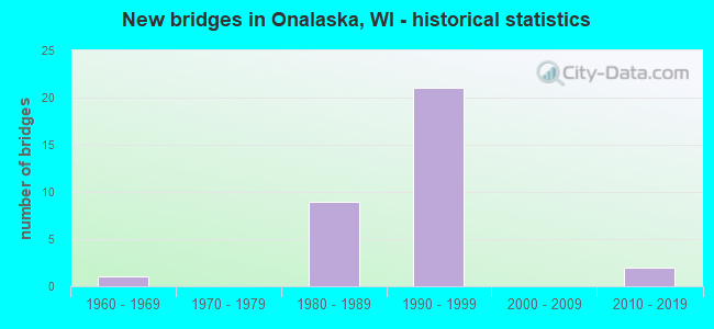
- New bridges - historical statistics
- 11960-1969
- 91980-1989
- 211990-1999
- 22010-2019
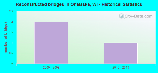
- Reconstructed bridges - Historical Statistics
- 22000-2009
- 12010-2019
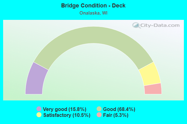
- Bridge Condition - Deck
- 15.8%Very good
- 68.4%Good
- 10.5%Satisfactory
- 5.3%Fair
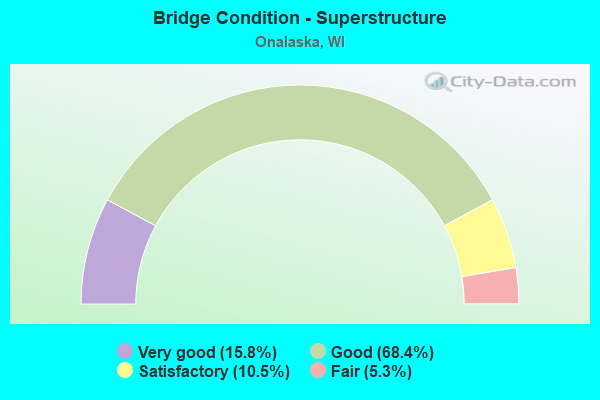
- Bridge Condition - Superstructure
- 15.8%Very good
- 68.4%Good
- 10.5%Satisfactory
- 5.3%Fair
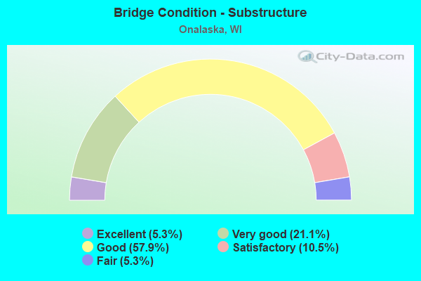
- Bridge Condition - Substructure
- 5.3%Excellent
- 21.1%Very good
- 57.9%Good
- 10.5%Satisfactory
- 5.3%Fair
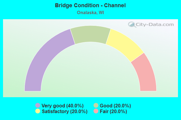
- Bridge Condition - Channel
- 40.0%Very good
- 20.0%Good
- 20.0%Satisfactory
- 20.0%Fair
Find on map >> Show street view
Structure Number: B320056, Location: 0.3M N JCT STH 157 TO E (Lat: 43.873686, Lng: -91.209411), Route carried "on" structure: US 53, Year Built: 1984, Status: Open, Structure Length: 6.86m (22.51ft), Average Daily Traffic: 16,400 (year 2019), Truck Traffic: 1%, Average Future Daily Traffic: 16,651 (year 2040), Design Load: HS 20, Features Intersected: IH 90
Minimum Vertical Clearance: 30+ m (98+ ft), Kilometerpoint: 0.000, Lanes on structure: 3, Lanes under structure: 6, Base Highway Network: Yes, Owner: State Highway Agency, Approaching Roadway Width: 15.8m (51.8ft), Skew: 2 degrees, Material/Design: Steel continuous, Design/Construction: Stringer/Multi-beam, Number Of Spans In Main Unit: 2, Length of Maximum Span: 33.5m (109.9ft), Curb-To-Curb Width: 15.8m (51.8ft), Out-to-Out Width: 16.8m (55.1ft)
Condition: Deck: Satisfactory, Superstructure: Satisfactory, Substructure: Satisfactory, Operating Rating: 62.1 metric tons, Method Used To Determine Operating Rating: Load Factor (LF), Inventory Rating: 35.6 metric tons, Method Used To Determine Inventory Rating: Load Factor (LF), Structural Evaluation: Equal to present minimum criteria, Deck Geometry: Better than present minimum criteria, Underclear: Somewhat better than minimum adequacy, Approach Roadway Alignment: Equal to present desirable criteria, Designated Inspection Frequency: Every 24 months, Inspection Date: March 2021, Deck Structure Type: Concrete Cast-file-Place, Wearing Surface/Protective System: Wearing Surface: Low Slump Concrete, Deck Protection: Epoxy Coated Reinforcing
Find on map >> Show street view
Structure Number: B320067, Location: 0.7M N JCT IH 90 (Lat: 43.870119, Lng: -91.231147), Route carried "on" structure: State highway 35, Year Built: 1967, Year Reconstructed: 2017, Status: Open, Structure Length: 12.09m (39.67ft), Average Daily Traffic: 6,200 (year 2019), Truck Traffic: 6%, Average Future Daily Traffic: 13,800 (year 2040), Design Load: HS 20, Features Intersected: BNSF RR (MP 302.850)
Minimum Vertical Clearance: 30+ m (98+ ft), Kilometerpoint: 0.000, Lanes on structure: 2, Base Highway Network: Yes, Owner: State Highway Agency, Approaching Roadway Width: 10.1m (33.1ft), Skew: 4 degrees, Material/Design: Steel continuous, Design/Construction: Stringer/Multi-beam, Number Of Spans In Main Unit: 5, Length of Maximum Span: 29.0m (95.1ft), Curb-To-Curb Width: 10.1m (33.1ft), Out-to-Out Width: 11.0m (36.1ft)
Condition: Deck: Very good, Superstructure: Good, Substructure: Good, Operating Rating: 44.1 metric tons, Method Used To Determine Operating Rating: Load Factor (LF), Inventory Rating: 25.9 metric tons, Method Used To Determine Inventory Rating: Load Factor (LF), Structural Evaluation: Equal to present minimum criteria, Deck Geometry: Somewhat better than minimum adequacy, Underclear: Equal to present desirable criteria, Approach Roadway Alignment: Equal to present desirable criteria, Designated Inspection Frequency: Every 24 months, Inspection Date: June 2021, Deck Structure Type: Concrete Cast-file-Place, Wearing Surface/Protective System: Wearing Surface: Epoxy Overlay, Deck Protection: Epoxy Coated Reinforcing
Find on map >> Show street view
Structure Number: B320101, Location: 0.1M N JCT CTH B (Lat: 43.893017, Lng: -90.920200), Route carried "on" structure: County highway , Year Built: 1989, Status: Open, Structure Length: 1.84m (6.04ft), Average Daily Traffic: 789 (year 2019), Average Future Daily Traffic: 358 (year 2040), Design Load: HS 20, Features Intersected: FISH CREEK, Facility Carried by Structure: CTH J
Minimum Vertical Clearance: 30+ m (98+ ft), Kilometerpoint: 0.000, Lanes on structure: 2, Owner: County Highway Agency, Approaching Roadway Width: 9.1m (29.9ft), Material/Design: Wood or Timber, Design/Construction: Slab, Number Of Spans In Main Unit: 3, Length of Maximum Span: 7.3m (24.0ft), Curb-To-Curb Width: 9.1m (29.9ft), Out-to-Out Width: 9.8m (32.2ft)
Condition: Deck: Satisfactory, Superstructure: Satisfactory, Substructure: Fair, Channel: Very good, Operating Rating: 50.6 metric tons, Method Used To Determine Operating Rating: Load Factor (LF), Inventory Rating: 35.6 metric tons, Method Used To Determine Inventory Rating: Load Factor (LF), Structural Evaluation: Somewhat better than minimum adequacy, Deck Geometry: Equal to present minimum criteria, Waterway Adequacy: Equal to present desirable criteria, Approach Roadway Alignment: Equal to present desirable criteria, Designated Inspection Frequency: Every 24 months, Inspection Date: April 2021, Deck Structure Type: Wood or Timber, Wearing Surface/Protective System: Wearing Surface: Bituminous
Find on map >> Show street view
Structure Number: B320107, Location: 1.3M E JCT USH 53 TO S (Lat: 43.870414, Lng: -91.218289), Route carried "on" structure: Interstate 90, Year Built: 1983, Year Reconstructed: 2014, Status: Open, Structure Length: 3.91m (12.83ft), Average Daily Traffic: 20,400 (year 2019), Truck Traffic: 15%, Average Future Daily Traffic: 20,297 (year 2040), Design Load: HS 20, Features Intersected: LRD 12TH AVE
Minimum Vertical Clearance: 30+ m (98+ ft), Kilometerpoint: 0.000, Lanes on structure: 3, Lanes under structure: 3, Base Highway Network: Yes, Owner: State Highway Agency, Approaching Roadway Width: 17.7m (58.1ft), Material/Design: Concrete continuous, Design/Construction: Slab, Number Of Spans In Main Unit: 3, Length of Maximum Span: 16.9m (55.4ft), Curb-To-Curb Width: 17.7m (58.1ft), Out-to-Out Width: 18.6m (61.0ft)
Condition: Deck: Good, Superstructure: Good, Substructure: Good, Operating Rating: 57.0 metric tons, Method Used To Determine Operating Rating: Load Factor (LF), Inventory Rating: 34.0 metric tons, Method Used To Determine Inventory Rating: Load Factor (LF), Structural Evaluation: Better than present minimum criteria, Deck Geometry: Better than present minimum criteria, Underclear: Meets minimum limits, Approach Roadway Alignment: Equal to present desirable criteria, Designated Inspection Frequency: Every 48 months, Inspection Date: November 2021, Deck Structure Type: Concrete Cast-file-Place, Wearing Surface/Protective System: Wearing Surface: Low Slump Concrete, Deck Protection: Epoxy Coated Reinforcing
Find on map >> Show street view
Structure Number: B320108, Location: 0.5M W JCT STH 157 (Lat: 43.870922, Lng: -91.218047), Route carried "on" structure: Interstate 90, Year Built: 1983, Year Reconstructed: 2014, Status: Open, Structure Length: 3.91m (12.83ft), Average Daily Traffic: 20,400 (year 2019), Truck Traffic: 14%, Average Future Daily Traffic: 26,356 (year 2040), Design Load: HS 20, Features Intersected: LRD 12TH AVE
Minimum Vertical Clearance: 30+ m (98+ ft), Kilometerpoint: 0.000, Lanes on structure: 3, Lanes under structure: 2, Base Highway Network: Yes, Owner: State Highway Agency, Approaching Roadway Width: 17.1m (56.1ft), Material/Design: Concrete continuous, Design/Construction: Slab, Number Of Spans In Main Unit: 3, Length of Maximum Span: 16.9m (55.4ft), Curb-To-Curb Width: 17.7m (58.1ft), Out-to-Out Width: 18.6m (61.0ft)
Condition: Deck: Good, Superstructure: Good, Substructure: Good, Operating Rating: 57.0 metric tons, Method Used To Determine Operating Rating: Load Factor (LF), Inventory Rating: 34.0 metric tons, Method Used To Determine Inventory Rating: Load Factor (LF), Structural Evaluation: Better than present minimum criteria, Deck Geometry: Better than present minimum criteria, Underclear: Meets minimum limits, Approach Roadway Alignment: Equal to present desirable criteria, Designated Inspection Frequency: Every 48 months, Inspection Date: November 2021, Deck Structure Type: Concrete Cast-file-Place, Wearing Surface/Protective System: Wearing Surface: Low Slump Concrete, Deck Protection: Epoxy Coated Reinforcing
Find on map >> Show street view
Structure Number: B32012, Location: 1.5M N JCT CTH EE (Lat: 43.981361, Lng: -90.946417), Route carried "on" structure: State highway 162, Year Built: 1987, Status: Open, Structure Length: 0.80m (2.62ft), Average Daily Traffic: 1,600 (year 2020), Truck Traffic: 5%, Average Future Daily Traffic: 2,000 (year 2040), Design Load: HS 20, Features Intersected: BURNS CREEK
Minimum Vertical Clearance: 30+ m (98+ ft), Kilometerpoint: 0.000, Lanes on structure: 2, Owner: State Highway Agency, Approaching Roadway Width: 10.4m (34.1ft), Material/Design: Concrete continuous, Design/Construction: Culvert, Number Of Spans In Main Unit: 2, Length of Maximum Span: 3.7m (12.1ft)
Condition: Channel: Fair, Culverts: Satisfactory, Operating Rating: 53.9 metric tons, Method Used To Determine Operating Rating: Field evaluation and documented engineering judgment, Inventory Rating: 32.4 metric tons, Method Used To Determine Inventory Rating: Field evaluation and documented engineering judgment, Structural Evaluation: Equal to present minimum criteria, Waterway Adequacy: Equal to present desirable criteria, Approach Roadway Alignment: Equal to present desirable criteria, Designated Inspection Frequency: Every 24 months, Inspection Date: August 2021, Deck Structure Type: Concrete Cast-file-Place, Wearing Surface/Protective System: Wearing Surface: Bituminous
Find on map >> Show street view
Structure Number: B320129, Location: 0.9M N JCT IH 90 TO E (Lat: 43.883856, Lng: -91.211061), Route carried "on" structure: US 53, Year Built: 1990, Status: Open, Structure Length: 5.63m (18.47ft), Average Daily Traffic: 16,400 (year 2019), Truck Traffic: 3%, Average Future Daily Traffic: 23,084 (year 2040), Design Load: HS 20, Features Intersected: STH 157 WB/MAIN ST
Minimum Vertical Clearance: 30+ m (98+ ft), Kilometerpoint: 0.000, Lanes on structure: 2, Lanes under structure: 6, Base Highway Network: Yes, Owner: State Highway Agency, Approaching Roadway Width: 12.2m (40.0ft), Skew: 1 degrees, Material/Design: Prestressed concrete continuous, Design/Construction: Stringer/Multi-beam, Number Of Spans In Main Unit: 2, Length of Maximum Span: 27.6m (90.6ft), Curb-To-Curb Width: 12.2m (40.0ft), Out-to-Out Width: 13.1m (43.0ft)
Condition: Deck: Good, Superstructure: Good, Substructure: Good, Operating Rating: 68.6 metric tons, Method Used To Determine Operating Rating: Load Factor (LF), Inventory Rating: 35.6 metric tons, Method Used To Determine Inventory Rating: Load Factor (LF), Structural Evaluation: Better than present minimum criteria, Deck Geometry: Better than present minimum criteria, Underclear: Equal to present minimum criteria, Approach Roadway Alignment: Equal to present desirable criteria, Designated Inspection Frequency: Every 48 months, Inspection Date: March 2021, Deck Structure Type: Concrete Cast-file-Place, Wearing Surface/Protective System: Wearing Surface: Epoxy Overlay, Deck Protection: Epoxy Coated Reinforcing
Find on map >> Show street view
Structure Number: B32013, Location: 1.2M S JCT CTH S (Lat: 43.884411, Lng: -91.211719), Route carried "on" structure: US 53, Year Built: 1990, Status: Open, Structure Length: 5.63m (18.47ft), Average Daily Traffic: 1,640 (year 2019), Truck Traffic: 3%, Average Future Daily Traffic: 18,056 (year 2040), Design Load: HS 20, Features Intersected: STH 157 WB
Minimum Vertical Clearance: 30+ m (98+ ft), Kilometerpoint: 0.000, Lanes on structure: 2, Lanes under structure: 6, Base Highway Network: Yes, Owner: State Highway Agency, Approaching Roadway Width: 12.2m (40.0ft), Skew: 1 degrees, Material/Design: Prestressed concrete continuous, Design/Construction: Stringer/Multi-beam, Number Of Spans In Main Unit: 2, Length of Maximum Span: 27.6m (90.6ft), Curb-To-Curb Width: 12.2m (40.0ft), Out-to-Out Width: 13.1m (43.0ft)
Condition: Deck: Good, Superstructure: Good, Substructure: Good, Operating Rating: 68.6 metric tons, Method Used To Determine Operating Rating: Load Factor (LF), Inventory Rating: 35.6 metric tons, Method Used To Determine Inventory Rating: Load Factor (LF), Structural Evaluation: Better than present minimum criteria, Deck Geometry: Better than present minimum criteria, Underclear: Equal to present minimum criteria, Approach Roadway Alignment: Equal to present desirable criteria, Designated Inspection Frequency: Every 48 months, Inspection Date: March 2021, Deck Structure Type: Concrete Cast-file-Place, Wearing Surface/Protective System: Wearing Surface: Epoxy Overlay, Deck Protection: Epoxy Coated Reinforcing
Find on map >> Show street view
Structure Number: B320131, Location: 1.1M N JCT STH 157 TO W (Lat: 43.898064, Lng: -91.220017), Route carried "on" structure: US 53, Year Built: 1990, Status: Open, Structure Length: 7.83m (25.69ft), Average Daily Traffic: 17,050 (year 2019), Truck Traffic: 3%, Average Future Daily Traffic: 19,924 (year 2040), Design Load: HS 20, Features Intersected: CTH S/SAND LAKE RD
Minimum Vertical Clearance: 30+ m (98+ ft), Kilometerpoint: 0.000, Lanes on structure: 2, Lanes under structure: 2, Base Highway Network: Yes, Owner: State Highway Agency, Approaching Roadway Width: 12.2m (40.0ft), Skew: 5 degrees, Material/Design: Steel continuous, Design/Construction: Stringer/Multi-beam, Number Of Spans In Main Unit: 2, Length of Maximum Span: 38.6m (126.6ft), Curb-To-Curb Width: 12.2m (40.0ft), Out-to-Out Width: 13.1m (43.0ft)
Condition: Deck: Good, Superstructure: Good, Substructure: Good, Operating Rating: 71.8 metric tons, Method Used To Determine Operating Rating: Load Factor (LF), Inventory Rating: 42.1 metric tons, Method Used To Determine Inventory Rating: Load Factor (LF), Structural Evaluation: Better than present minimum criteria, Deck Geometry: Better than present minimum criteria, Underclear: Equal to present minimum criteria, Approach Roadway Alignment: Equal to present desirable criteria, Designated Inspection Frequency: Every 48 months, Inspection Date: March 2021, Deck Structure Type: Concrete Cast-file-Place, Wearing Surface/Protective System: Wearing Surface: Epoxy Overlay, Deck Protection: Epoxy Coated Reinforcing
Find on map >> Show street view
Structure Number: B320132, Location: 1.9M S JCT CTH OT (Lat: 43.898158, Lng: -91.220633), Route carried "on" structure: US 53, Year Built: 1990, Status: Open, Structure Length: 7.83m (25.69ft), Average Daily Traffic: 17,050 (year 2019), Truck Traffic: 3%, Average Future Daily Traffic: 18,835 (year 2040), Design Load: HS 20, Features Intersected: CTH S/SAND LAKE RD
Minimum Vertical Clearance: 30+ m (98+ ft), Kilometerpoint: 0.000, Lanes on structure: 2, Lanes under structure: 2, Base Highway Network: Yes, Owner: State Highway Agency, Approaching Roadway Width: 12.2m (40.0ft), Skew: 5 degrees, Material/Design: Steel continuous, Design/Construction: Stringer/Multi-beam, Number Of Spans In Main Unit: 2, Length of Maximum Span: 38.6m (126.6ft), Curb-To-Curb Width: 12.2m (40.0ft), Out-to-Out Width: 13.1m (43.0ft)
Condition: Deck: Good, Superstructure: Good, Substructure: Good, Operating Rating: 71.8 metric tons, Method Used To Determine Operating Rating: Load Factor (LF), Inventory Rating: 42.1 metric tons, Method Used To Determine Inventory Rating: Load Factor (LF), Structural Evaluation: Better than present minimum criteria, Deck Geometry: Better than present minimum criteria, Underclear: Equal to present minimum criteria, Approach Roadway Alignment: Equal to present desirable criteria, Designated Inspection Frequency: Every 48 months, Inspection Date: March 2021, Deck Structure Type: Concrete Cast-file-Place, Wearing Surface/Protective System: Wearing Surface: Epoxy Overlay, Deck Protection: Epoxy Coated Reinforcing
Find on map >> Show street view
Structure Number: B320133, Location: 0.5M N JCT CTH S (Lat: 43.905294, Lng: -91.227558), Route carried "on" structure: US 53, Year Built: 1990, Status: Open, Structure Length: 4.95m (16.24ft), Average Daily Traffic: 17,050 (year 2019), Truck Traffic: 3%, Average Future Daily Traffic: 17,763 (year 2040), Design Load: HS 20, Features Intersected: LRD RIDERS CLUB ROAD
Minimum Vertical Clearance: 30+ m (98+ ft), Kilometerpoint: 0.000, Lanes on structure: 2, Lanes under structure: 2, Base Highway Network: Yes, Owner: State Highway Agency, Approaching Roadway Width: 12.2m (40.0ft), Skew: 3 degrees, Material/Design: Prestressed concrete continuous, Design/Construction: Stringer/Multi-beam, Number Of Spans In Main Unit: 3, Length of Maximum Span: 26.8m (87.9ft), Curb-To-Curb Width: 12.2m (40.0ft), Out-to-Out Width: 12.8m (42.0ft)
Condition: Deck: Good, Superstructure: Good, Substructure: Good, Operating Rating: 82.0 metric tons, Method Used To Determine Operating Rating: Load Factor (LF), Inventory Rating: 43.7 metric tons, Method Used To Determine Inventory Rating: Load Factor (LF), Structural Evaluation: Better than present minimum criteria, Deck Geometry: Better than present minimum criteria, Underclear: Better than present minimum criteria, Approach Roadway Alignment: Equal to present desirable criteria, Designated Inspection Frequency: Every 48 months, Inspection Date: March 2021, Wearing Surface/Protective System: Wearing Surface: Epoxy Overlay, Deck Protection: Epoxy Coated Reinforcing
Find on map >> Show street view
Structure Number: B320134, Location: 2.3M S JCT STH 35 TO S (Lat: 43.905714, Lng: -91.228517), Route carried "on" structure: US 53, Year Built: 1990, Status: Open, Structure Length: 4.95m (16.24ft), Average Daily Traffic: 17,050 (year 2019), Truck Traffic: 3%, Average Future Daily Traffic: 18,835 (year 2040), Design Load: HS 20, Features Intersected: LRD RIDER'S CLUB ROAD
Minimum Vertical Clearance: 30+ m (98+ ft), Kilometerpoint: 0.000, Lanes on structure: 2, Lanes under structure: 2, Base Highway Network: Yes, Owner: State Highway Agency, Approaching Roadway Width: 12.2m (40.0ft), Skew: 3 degrees, Material/Design: Prestressed concrete continuous, Design/Construction: Stringer/Multi-beam, Number Of Spans In Main Unit: 3, Length of Maximum Span: 26.8m (87.9ft), Curb-To-Curb Width: 12.2m (40.0ft), Out-to-Out Width: 12.8m (42.0ft)
Condition: Deck: Good, Superstructure: Good, Substructure: Satisfactory, Operating Rating: 82.0 metric tons, Method Used To Determine Operating Rating: Load Factor (LF), Inventory Rating: 43.7 metric tons, Method Used To Determine Inventory Rating: Load Factor (LF), Structural Evaluation: Equal to present minimum criteria, Deck Geometry: Better than present minimum criteria, Underclear: Somewhat better than minimum adequacy, Approach Roadway Alignment: Equal to present desirable criteria, Designated Inspection Frequency: Every 24 months, Inspection Date: March 2021, Deck Structure Type: Concrete Cast-file-Place, Wearing Surface/Protective System: Wearing Surface: Epoxy Overlay, Deck Protection: Epoxy Coated Reinforcing
Find on map >> Show street view
Structure Number: B320135, Location: 0.6M N JCT CTH S (Lat: 43.912653, Lng: -91.234908), Route carried "on" structure: US 53, Year Built: 1990, Status: Open, Structure Length: 8.51m (27.92ft), Average Daily Traffic: 17,050 (year 2019), Truck Traffic: 3%, Average Future Daily Traffic: 19,924 (year 2040), Design Load: HS 20, Features Intersected: LRD EAST AVE. N.
Minimum Vertical Clearance: 30+ m (98+ ft), Kilometerpoint: 0.000, Lanes on structure: 2, Lanes under structure: 2, Base Highway Network: Yes, Owner: State Highway Agency, Approaching Roadway Width: 12.2m (40.0ft), Skew: 6 degrees, Material/Design: Steel continuous, Design/Construction: Stringer/Multi-beam, Number Of Spans In Main Unit: 3, Length of Maximum Span: 36.9m (121.1ft), Curb-To-Curb Width: 12.2m (40.0ft), Out-to-Out Width: 13.1m (43.0ft)
Condition: Deck: Good, Superstructure: Good, Substructure: Good, Operating Rating: 73.0 metric tons, Method Used To Determine Operating Rating: Load Factor (LF), Inventory Rating: 43.7 metric tons, Method Used To Determine Inventory Rating: Load Factor (LF), Structural Evaluation: Better than present minimum criteria, Deck Geometry: Better than present minimum criteria, Underclear: Somewhat better than minimum adequacy, Approach Roadway Alignment: Equal to present desirable criteria, Designated Inspection Frequency: Every 48 months, Inspection Date: March 2021, Deck Structure Type: Concrete Cast-file-Place, Wearing Surface/Protective System: Wearing Surface: Epoxy Overlay, Deck Protection: Epoxy Coated Reinforcing
Find on map >> Show street view
Structure Number: B320136, Location: 1.1M S JCT STH 35 TO S (Lat: 43.912714, Lng: -91.235456), Route carried "on" structure: US 53, Year Built: 1990, Status: Open, Structure Length: 8.29m (27.20ft), Average Daily Traffic: 17,050 (year 2019), Truck Traffic: 3%, Average Future Daily Traffic: 18,835 (year 2040), Design Load: HS 20, Features Intersected: LRD EAST AVE. N.
Minimum Vertical Clearance: 30+ m (98+ ft), Kilometerpoint: 0.000, Lanes on structure: 2, Lanes under structure: 2, Base Highway Network: Yes, Owner: State Highway Agency, Approaching Roadway Width: 13.4m (44.0ft), Skew: 6 degrees, Material/Design: Steel continuous, Design/Construction: Stringer/Multi-beam, Number Of Spans In Main Unit: 3, Length of Maximum Span: 36.9m (121.1ft), Curb-To-Curb Width: 12.2m (40.0ft), Out-to-Out Width: 13.1m (43.0ft)
Condition: Deck: Good, Superstructure: Good, Substructure: Good, Operating Rating: 58.8 metric tons, Method Used To Determine Operating Rating: Load Factor (LF), Inventory Rating: 34.0 metric tons, Method Used To Determine Inventory Rating: Load Factor (LF), Structural Evaluation: Better than present minimum criteria, Deck Geometry: Better than present minimum criteria, Underclear: Somewhat better than minimum adequacy, Approach Roadway Alignment: Equal to present desirable criteria, Designated Inspection Frequency: Every 48 months, Inspection Date: March 2021, Deck Structure Type: Concrete Cast-file-Place, Wearing Surface/Protective System: Wearing Surface: Epoxy Overlay, Deck Protection: Epoxy Coated Reinforcing
Find on map >> Show street view
Structure Number: B320156, Location: 0.6M N JCT CTH OS (Lat: 43.888133, Lng: -91.180050), Route carried "on" structure: City street , Year Built: 1989, Status: Open, Structure Length: 1.41m (4.63ft), Average Daily Traffic: 65 (year 2019), Truck Traffic: 3%, Average Future Daily Traffic: 66 (year 2039), Design Load: HS 20, Features Intersected: BR LACROSSE RIVER, Facility Carried by Structure: LRD MARCOU ROAD (D
Minimum Vertical Clearance: 30+ m (98+ ft), Kilometerpoint: 0.000, Lanes on structure: 2, Owner: City or Municipal Highway Agency, Approaching Roadway Width: 11.0m (36.1ft), Skew: 2 degrees, Material/Design: Prestressed concrete, Design/Construction: Stringer/Multi-beam, Number Of Spans In Main Unit: 1, Length of Maximum Span: 13.4m (44.0ft), Curb-To-Curb Width: 7.3m (24.0ft), Out-to-Out Width: 7.9m (25.9ft)
Condition: Deck: Good, Superstructure: Very good, Substructure: Very good, Channel: Satisfactory, Operating Rating: 58.8 metric tons, Method Used To Determine Operating Rating: Load Factor (LF), Inventory Rating: 38.9 metric tons, Method Used To Determine Inventory Rating: Load Factor (LF), Structural Evaluation: Equal to present desirable criteria, Deck Geometry: Equal to present minimum criteria, Waterway Adequacy: Equal to present desirable criteria, Approach Roadway Alignment: Equal to present desirable criteria, Designated Inspection Frequency: Every 24 months, Inspection Date: April 2020, Deck Structure Type: Concrete Cast-file-Place, Wearing Surface/Protective System: Wearing Surface: Monolithic Concrete, Deck Protection: Epoxy Coated Reinforcing
Find on map >> Show street view
Structure Number: B32018, Location: 0.1M W JCT CTH M (Lat: 43.928000, Lng: -91.113014), Route carried "on" structure: City street , Year Built: 1992, Status: Open, Structure Length: 1.16m (3.81ft), Average Daily Traffic: 10 (year 2019), Truck Traffic: 10%, Average Future Daily Traffic: 11 (year 2041), Design Load: HS 20, Features Intersected: LARSON COULEE CREEK, Facility Carried by Structure: LRD ERICKSON RD (D
Minimum Vertical Clearance: 30+ m (98+ ft), Kilometerpoint: 0.000, Lanes on structure: 2, Owner: Town or Township Highway Agency, Approaching Roadway Width: 7.3m (24.0ft), Skew: 2 degrees, Material/Design: Concrete, Design/Construction: Slab, Number Of Spans In Main Unit: 1, Length of Maximum Span: 11.0m (36.1ft), Curb-To-Curb Width: 7.3m (24.0ft), Out-to-Out Width: 7.9m (25.9ft)
Condition: Deck: Good, Superstructure: Good, Substructure: Very good, Channel: Good, Operating Rating: 57.0 metric tons, Method Used To Determine Operating Rating: Load Factor (LF), Inventory Rating: 34.0 metric tons, Method Used To Determine Inventory Rating: Load Factor (LF), Structural Evaluation: Better than present minimum criteria, Deck Geometry: Equal to present minimum criteria, Waterway Adequacy: Equal to present desirable criteria, Approach Roadway Alignment: Equal to present desirable criteria, Designated Inspection Frequency: Every 48 months, Inspection Date: Febuary 2022, Deck Structure Type: Concrete Cast-file-Place, Wearing Surface/Protective System: Wearing Surface: Monolithic Concrete, Deck Protection: Epoxy Coated Reinforcing
Find on map >> Show street view
Structure Number: B320189, Location: 0.6M E JCT I90/STH157 (Lat: 43.876814, Lng: -91.196917), Route carried "on" structure: Interstate 90, Year Built: 1996, Status: Open, Structure Length: 4.85m (15.91ft), Average Daily Traffic: 16,250 (year 2019), Truck Traffic: 16%, Average Future Daily Traffic: 21,157 (year 2040), Design Load: HS 20, Features Intersected: LRD THEATER RD
Minimum Vertical Clearance: 30+ m (98+ ft), Kilometerpoint: 0.000, Lanes on structure: 3, Lanes under structure: 4, Base Highway Network: Yes, Owner: State Highway Agency, Approaching Roadway Width: 15.8m (51.8ft), Material/Design: Concrete continuous, Design/Construction: Slab, Number Of Spans In Main Unit: 3, Length of Maximum Span: 20.1m (65.9ft), Curb-To-Curb Width: 15.8m (51.8ft), Out-to-Out Width: 16.8m (55.1ft)
Condition: Deck: Fair, Superstructure: Fair, Substructure: Good, Operating Rating: 58.8 metric tons, Method Used To Determine Operating Rating: Load Factor (LF), Inventory Rating: 34.0 metric tons, Method Used To Determine Inventory Rating: Load Factor (LF), Structural Evaluation: Somewhat better than minimum adequacy, Deck Geometry: Somewhat better than minimum adequacy, Underclear: Somewhat better than minimum adequacy, Approach Roadway Alignment: Equal to present desirable criteria, Designated Inspection Frequency: Every 24 months, Inspection Date: November 2021, Deck Structure Type: Concrete Cast-file-Place, Wearing Surface/Protective System: Wearing Surface: Monolithic Concrete, Deck Protection: Epoxy Coated Reinforcing
Find on map >> Show street view
Structure Number: B32019, Location: 0.5M W JCT I90/STH16 (Lat: 43.877192, Lng: -91.196314), Route carried "on" structure: Interstate 90, Year Built: 1996, Status: Open, Structure Length: 4.85m (15.91ft), Average Daily Traffic: 16,250 (year 2019), Average Future Daily Traffic: 14,400 (year 2040), Design Load: HS 20, Features Intersected: LRD THEATER RD
Minimum Vertical Clearance: 30+ m (98+ ft), Kilometerpoint: 0.000, Lanes on structure: 3, Lanes under structure: 4, Base Highway Network: Yes, Owner: State Highway Agency, Approaching Roadway Width: 15.8m (51.8ft), Material/Design: Concrete continuous, Design/Construction: Slab, Number Of Spans In Main Unit: 3, Length of Maximum Span: 20.1m (65.9ft), Curb-To-Curb Width: 15.8m (51.8ft), Out-to-Out Width: 16.8m (55.1ft)
Condition: Deck: Good, Superstructure: Good, Substructure: Very good, Operating Rating: 57.0 metric tons, Method Used To Determine Operating Rating: Load Factor (LF), Inventory Rating: 34.0 metric tons, Method Used To Determine Inventory Rating: Load Factor (LF), Structural Evaluation: Better than present minimum criteria, Deck Geometry: Somewhat better than minimum adequacy, Underclear: Meets minimum limits, Approach Roadway Alignment: Equal to present desirable criteria, Designated Inspection Frequency: Every 48 months, Inspection Date: November 2021, Deck Structure Type: Concrete Cast-file-Place, Wearing Surface/Protective System: Wearing Surface: Low Slump Concrete, Membrane: Other, Deck Protection: Epoxy Coated Reinforcing
Find on map >> Show street view
Structure Number: B320224, Location: 0.9M S JCT STH 157 (Lat: 43.871519, Lng: -91.230733), Route carried "on" structure: State highway 35, Year Built: 2016, Status: Open, Structure Length: 12.27m (40.26ft), Average Daily Traffic: 12,400 (year 2019), Truck Traffic: 6%, Average Future Daily Traffic: 27,600 (year 2036), Design Load: HL 93, Features Intersected: BNSF RR
Minimum Vertical Clearance: 30+ m (98+ ft), Kilometerpoint: 0.000, Lanes on structure: 2, Base Highway Network: Yes, Owner: State Highway Agency, Approaching Roadway Width: 9.4m (30.8ft), Skew: 5 degrees, Material/Design: Prestressed concrete, Design/Construction: Stringer/Multi-beam, Number Of Spans In Main Unit: 5, Length of Maximum Span: 31.1m (102.0ft), Curb or Sidewalk Widths: Left: 3.7m (12.1ft), Right: 0.0m, Curb-To-Curb Width: 9.4m (30.8ft), Out-to-Out Width: 14.4m (47.2ft)
Condition: Deck: Very good, Superstructure: Very good, Substructure: Very good, Operating Rating: 44.7 metric tons, Method Used To Determine Operating Rating: Load and Resistance Factor Rating (LRFR) rating reported by rating factor(RF) method using HL-93 loadings, Inventory Rating: 34.0 metric tons, Method Used To Determine Inventory Rating: Load and Resistance Factor Rating (LRFR) rating reported by rating factor(RF) method using HL-93 loadings, Structural Evaluation: Equal to present desirable criteria, Deck Geometry: Meets minimum limits, Underclear: Equal to present minimum criteria, Approach Roadway Alignment: Equal to present desirable criteria, Designated Inspection Frequency: Every 48 months, Inspection Date: June 2019, Deck Structure Type: Concrete Cast-file-Place, Wearing Surface/Protective System: Wearing Surface: Epoxy Overlay
Find on map >> Show street view
Structure Number: B320236, Location: 0.4M N JCT CTH OT (Lat: 43.929650, Lng: -91.238483), Route carried "on" structure: County highway , Year Built: 2019, Status: Open, Structure Length: 1.23m (4.04ft), Average Daily Traffic: 6,300 (year 2018), Truck Traffic: 4%, Average Future Daily Traffic: 7,900 (year 2038), Design Load: HL 93, Features Intersected: BR SAND LAKE COULEE CRK, Facility Carried by Structure: CTH SN
Minimum Vertical Clearance: 30+ m (98+ ft), Kilometerpoint: 0.000, Lanes on structure: 2, Owner: County Highway Agency, Approaching Roadway Width: 11.0m (36.1ft), Skew: 1 degrees, Material/Design: Concrete, Design/Construction: Slab, Number Of Spans In Main Unit: 1, Length of Maximum Span: 11.9m (39.0ft), Curb or Sidewalk Widths: Left: 3.7m (12.1ft), Right: 0.0m, Curb-To-Curb Width: 11.0m (36.1ft), Out-to-Out Width: 15.8m (51.8ft)
Condition: Deck: Very good, Superstructure: Very good, Substructure: Excellent, Channel: Very good, Operating Rating: 70.0 metric tons, Method Used To Determine Operating Rating: Load and Resistance Factor Rating (LRFR) rating reported by rating factor(RF) method using HL-93 loadings, Inventory Rating: 47.6 metric tons, Method Used To Determine Inventory Rating: Load and Resistance Factor Rating (LRFR) rating reported by rating factor(RF) method using HL-93 loadings, Structural Evaluation: Equal to present desirable criteria, Deck Geometry: Meets minimum limits, Waterway Adequacy: Superior to present desirable criteria, Approach Roadway Alignment: Equal to present desirable criteria, Designated Inspection Frequency: Every 48 months, Inspection Date: March 2021, Deck Structure Type: Concrete Cast-file-Place, Wearing Surface/Protective System: Wearing Surface: Monolithic Concrete, Deck Protection: Epoxy Coated Reinforcing
Find on map >> Show street view
Structure Number: B320056, Location: 1.7M E JCT USH 53 TO S (Lat: 43.873686, Lng: -91.209411), Route carried "under" structure: Interstate 90, Year Built: 1984, Structure Length: 0. m, Average Daily Traffic: 32,500 (year 2019), Features Intersected: IH 90, Facility Carried by Structure: USH 53 NB-STH 157
Minimum Vertical Clearance: 4.98m (16.34ft), Kilometerpoint: 0.000, Lanes on structure: 3, Lanes under structure: 6, Material/Design: Steel continuous, Design/Construction: Stringer/Multi-beam, Length of Maximum Span: 33.5m (109.9ft)
Find on map >> Show street view
Structure Number: B320107, Location: AT JCT IH 90 (Lat: 43.870414, Lng: -91.218289), Route carried "under" structure: City street , Year Built: 1983, Structure Length: 0. m, Average Daily Traffic: 6,500 (year 2019), Features Intersected: LRD 12TH AVE, Facility Carried by Structure: IH 90 EB-USH 53 NB
Minimum Vertical Clearance: 4.51m (14.80ft), Kilometerpoint: 0.000, Lanes on structure: 3, Lanes under structure: 3, Material/Design: Concrete continuous, Design/Construction: Slab, Length of Maximum Span: 16.9m (55.4ft)
Find on map >> Show street view
Structure Number: B320108, Location: AT JCT IH 90 (Lat: 43.870922, Lng: -91.218047), Route carried "under" structure: City street , Year Built: 1983, Structure Length: 0. m, Average Daily Traffic: 6,500 (year 2019), Features Intersected: LRD 12TH AVE, Facility Carried by Structure: IH 90 WB-USH 53 SB
Minimum Vertical Clearance: 4.54m (14.90ft), Kilometerpoint: 0.000, Lanes on structure: 3, Lanes under structure: 2, Material/Design: Concrete continuous, Design/Construction: Slab, Length of Maximum Span: 16.9m (55.4ft)
Find on map >> Show street view
Structure Number: B320129, Location: 0.7M W JCT IH 90 TO W (Lat: 43.883856, Lng: -91.211061), Route carried "under" structure: State highway 157, Year Built: 1990, Structure Length: 0. m, Average Daily Traffic: 11,000 (year 2019), Truck Traffic: 5%, Features Intersected: STH 157 WB/MAIN ST, Facility Carried by Structure: USH 53 NB
Minimum Vertical Clearance: 5.43m (17.81ft), Kilometerpoint: 0.000, Lanes on structure: 2, Lanes under structure: 6, Material/Design: Prestressed concrete continuous, Design/Construction: Stringer/Multi-beam, Length of Maximum Span: 27.6m (90.6ft)
Find on map >> Show street view
Structure Number: B32013, Location: 0.8M W JCT IH 90 TO W (Lat: 43.884411, Lng: -91.211719), Route carried "under" structure: State highway 157, Year Built: 1990, Structure Length: 0. m, Average Daily Traffic: 11,000 (year 2019), Features Intersected: STH 157 WB, Facility Carried by Structure: USH 53 SB
Minimum Vertical Clearance: 5.04m (16.54ft), Kilometerpoint: 0.000, Lanes on structure: 2, Lanes under structure: 6, Material/Design: Prestressed concrete continuous, Design/Construction: Stringer/Multi-beam, Length of Maximum Span: 27.6m (90.6ft)
Find on map >> Show street view
Structure Number: B320131, Location: CITY OF ONALASKA (Lat: 43.898064, Lng: -91.220017), Route carried "under" structure: County highway , Year Built: 1990, Structure Length: 0. m, Average Daily Traffic: 13,800 (year 2019), Features Intersected: CTH S/SAND LAKE RD, Facility Carried by Structure: USH 53 NB
Minimum Vertical Clearance: 4.95m (16.24ft), Kilometerpoint: 0.000, Lanes on structure: 2, Lanes under structure: 2, Material/Design: Steel continuous, Design/Construction: Stringer/Multi-beam, Length of Maximum Span: 38.6m (126.6ft)
Find on map >> Show street view
Structure Number: B320132, Location: CITY OF ONALASKA (Lat: 43.898158, Lng: -91.220633), Route carried "under" structure: County highway , Year Built: 1990, Structure Length: 0. m, Average Daily Traffic: 13,800 (year 2019), Features Intersected: CTH S/SAND LAKE RD, Facility Carried by Structure: USH 53 SB
Minimum Vertical Clearance: 5.26m (17.26ft), Kilometerpoint: 0.000, Lanes on structure: 2, Lanes under structure: 2, Material/Design: Steel continuous, Design/Construction: Stringer/Multi-beam, Length of Maximum Span: 38.6m (126.6ft)
Find on map >> Show street view
Structure Number: B320133, Location: AT USH 53 (Lat: 43.905294, Lng: -91.227558), Route carried "under" structure: City street , Year Built: 1990, Structure Length: 0. m, Average Daily Traffic: 5,900 (year 2019), Features Intersected: LRD RIDERS CLUB ROAD, Facility Carried by Structure: USH 53 NB
Minimum Vertical Clearance: 5.00m (16.40ft), Kilometerpoint: 0.000, Lanes on structure: 2, Lanes under structure: 2, Material/Design: Prestressed concrete continuous, Design/Construction: Stringer/Multi-beam, Length of Maximum Span: 26.8m (87.9ft)
Find on map >> Show street view
Structure Number: B320134, Location: CITY OF ONALASKA (Lat: 43.905714, Lng: -91.228517), Route carried "under" structure: City street , Year Built: 1990, Structure Length: 0. m, Average Daily Traffic: 5,900 (year 2019), Features Intersected: LRD RIDER'S CLUB ROAD, Facility Carried by Structure: USH 53 SB
Minimum Vertical Clearance: 4.71m (15.45ft), Kilometerpoint: 0.000, Lanes on structure: 2, Lanes under structure: 2, Material/Design: Prestressed concrete continuous, Design/Construction: Stringer/Multi-beam, Length of Maximum Span: 26.8m (87.9ft)
Find on map >> Show street view
Structure Number: B320135, Location: CITY OF ONALASKA (Lat: 43.912653, Lng: -91.234908), Route carried "under" structure: City street , Year Built: 1990, Structure Length: 0. m, Average Daily Traffic: 3,900 (year 2019), Features Intersected: LRD EAST AVE. N., Facility Carried by Structure: USH 53 NB
Minimum Vertical Clearance: 4.60m (15.09ft), Kilometerpoint: 0.000, Lanes on structure: 2, Lanes under structure: 2, Material/Design: Steel continuous, Design/Construction: Stringer/Multi-beam, Length of Maximum Span: 36.9m (121.1ft)
Find on map >> Show street view
Structure Number: B320136, Location: CITY OF ONALASKA (Lat: 43.912714, Lng: -91.235456), Route carried "under" structure: City street , Year Built: 1990, Structure Length: 0. m, Average Daily Traffic: 3,900 (year 2019), Features Intersected: LRD EAST AVE. N., Facility Carried by Structure: USH 53 SB
Minimum Vertical Clearance: 4.34m (14.24ft), Kilometerpoint: 0.000, Lanes on structure: 2, Lanes under structure: 2, Material/Design: Steel continuous, Design/Construction: Stringer/Multi-beam, Length of Maximum Span: 36.9m (121.1ft)
Find on map >> Show street view
Structure Number: B320189, Location: CITY OF ONALASKA (Lat: 43.876814, Lng: -91.196917), Route carried "under" structure: City street , Year Built: 1996, Structure Length: 0. m, Average Daily Traffic: 10,600 (year 2019), Features Intersected: LRD THEATER RD, Facility Carried by Structure: IH 90 EB
Minimum Vertical Clearance: 4.65m (15.26ft), Kilometerpoint: 0.000, Lanes on structure: 3, Lanes under structure: 4, Material/Design: Concrete continuous, Design/Construction: Slab, Length of Maximum Span: 20.1m (65.9ft)
Find on map >> Show street view
Structure Number: B32019, Location: CITY OF ONALASKA (Lat: 43.877192, Lng: -91.196314), Route carried "under" structure: City street , Year Built: 1996, Structure Length: 0. m, Average Daily Traffic: 10,600 (year 2019), Features Intersected: LRD THEATER RD, Facility Carried by Structure: IH 90 WB
Minimum Vertical Clearance: 4.75m (15.58ft), Kilometerpoint: 0.000, Lanes on structure: 3, Lanes under structure: 4, Material/Design: Concrete continuous, Design/Construction: Slab, Length of Maximum Span: 20.1m (65.9ft)