Bridge Statistics for Orinda, California (CA)
Condition, Traffic, Stress, Structural Evaluation, Project Costs
- National Bridge Inventory (NBI) Statistics
- 22Number of bridges
- 144ft / 44.4mTotal length
- $1,794,000Total costs
- 794,801Total average daily traffic
- 21,698Total average daily truck traffic
- National Bridge Inventory (NBI) Registered Bridges for Orinda
- No street view available for this location
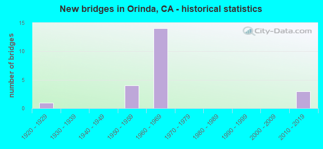
- New bridges - historical statistics
- 11920-1929
- 41950-1959
- 141960-1969
- 32010-2019
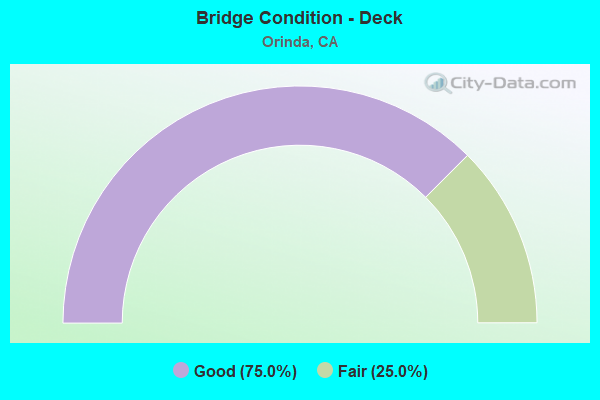
- Bridge Condition - Deck
- 75.0%Good
- 25.0%Fair
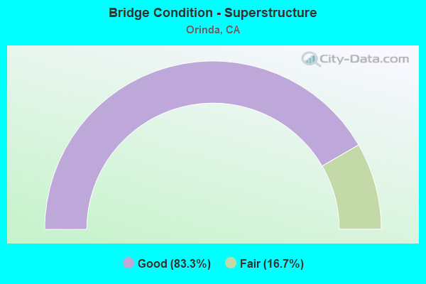
- Bridge Condition - Superstructure
- 83.3%Good
- 16.7%Fair
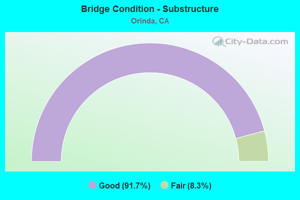
- Bridge Condition - Substructure
- 91.7%Good
- 8.3%Fair
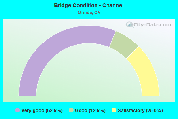
- Bridge Condition - Channel
- 62.5%Very good
- 12.5%Good
- 25.0%Satisfactory
Find on map >> Show street view
Structure Number: 28 0103L, Location: 04-CC-024-R2.31-ORIN (Lat: 37.879086, Lng: -122.184797), Route carried "on" structure: State highway 24, Year Built: 1969, Status: Open, Structure Length: 3.35m (10.99ft), Average Daily Traffic: 79,500 (year 2019), Truck Traffic: 3%, Average Future Daily Traffic: 116,615 (year 2039), Design Load: HS 20+Mod, Features Intersected: CAMINO PABLO
Minimum Vertical Clearance: 30+ m (98+ ft), Kilometerpoint: 2.310, Lanes on structure: 4, Lanes under structure: 6, Base Highway Network: Yes (, Subroute: 1), Owner: State Highway Agency, Approaching Roadway Width: 20.1m (65.9ft), Material/Design: Prestressed concrete, Design/Construction: Box Beam or Girders - Multiple, Number Of Spans In Main Unit: 1, Length of Maximum Span: 32.6m (107.0ft), Curb-To-Curb Width: 20.1m (65.9ft), Out-to-Out Width: 20.7m (67.9ft)
Condition: Deck: Good, Superstructure: Good, Substructure: Good, Operating Rating: 55.1 metric tons, Method Used To Determine Operating Rating: Load and Resistance Factor Rating (LRFR) rating reported by rating factor(RF) method using HL-93 loadings, Inventory Rating: 36.9 metric tons, Method Used To Determine Inventory Rating: Load and Resistance Factor Rating (LRFR) rating reported by rating factor(RF) method using HL-93 loadings, Structural Evaluation: Better than present minimum criteria, Deck Geometry: Equal to present minimum criteria, Underclear: Somewhat better than minimum adequacy, Approach Roadway Alignment: Equal to present desirable criteria, Designated Inspection Frequency: Every 24 months, Inspection Date: June 2021, Deck Structure Type: Concrete Cast-file-Place
Find on map >> Show street view
Structure Number: 28 0103R, Location: 04-CC-024-R2.31-ORIN (Lat: 37.878236, Lng: -122.183344), Route carried "on" structure: State highway 24, Year Built: 1954, Year Reconstructed: 1970, Status: Open, Structure Length: 2.77m (9.09ft), Average Daily Traffic: 79,500 (year 2019), Truck Traffic: 3%, Average Future Daily Traffic: 117,394 (year 2041), Design Load: HS 20, Features Intersected: CAMINO PABLO
Minimum Vertical Clearance: 30+ m (98+ ft), Kilometerpoint: 2.310, Lanes on structure: 5, Lanes under structure: 6, Base Highway Network: Yes (, Subroute: 1), Owner: State Highway Agency, Approaching Roadway Width: 23.2m (76.1ft), Material/Design: Concrete, Design/Construction: Box Beam or Girders - Multiple, Number Of Spans In Main Unit: 1, Length of Maximum Span: 27.3m (89.6ft), Curb-To-Curb Width: 23.3m (76.4ft), Out-to-Out Width: 23.9m (78.4ft)
Condition: Deck: Fair, Superstructure: Fair, Substructure: Good, Operating Rating: 77.1 metric tons, Method Used To Determine Operating Rating: Load Factor (LF), Inventory Rating: 32.4 metric tons, Method Used To Determine Inventory Rating: Load Factor (LF), Structural Evaluation: Somewhat better than minimum adequacy, Deck Geometry: Somewhat better than minimum adequacy, Underclear: High priority of corrective action, Approach Roadway Alignment: Equal to present desirable criteria, Designated Inspection Frequency: Every 24 months, Inspection Date: June 2021, Deck Structure Type: Concrete Cast-file-Place
Find on map >> Show street view
Structure Number: 28 0111, Location: 04-CC-024-R3.47-ORIN (Lat: 37.891989, Lng: -122.171486), Route carried "on" structure: City street , Year Built: 1969, Status: Open, Structure Length: 8.20m (26.90ft), Average Daily Traffic: 4,500 (year 2019), Truck Traffic: 1%, Average Future Daily Traffic: 5,453 (year 2041), Design Load: HS 20+Mod, Features Intersected: STATE ROUTE 24 & BARTD, Facility Carried by Structure: ST STEPHENS DRIVE
Minimum Vertical Clearance: 30+ m (98+ ft), Kilometerpoint: 0.000, Lanes on structure: 2, Lanes under structure: 10, Base Highway Network: Yes, Owner: State Highway Agency, Approaching Roadway Width: 12.2m (40.0ft), Material/Design: Concrete continuous, Design/Construction: Box Beam or Girders - Multiple, Number Of Spans In Main Unit: 3, Length of Maximum Span: 31.7m (104.0ft), Curb or Sidewalk Widths: Left: 1.5m (4.9ft), Right: 1.5m (4.9ft), Curb-To-Curb Width: 12.2m (40.0ft), Out-to-Out Width: 15.8m (51.8ft)
Condition: Deck: Good, Superstructure: Good, Substructure: Good, Operating Rating: 37.3 metric tons, Method Used To Determine Operating Rating: Load and Resistance Factor Rating (LRFR) rating reported by rating factor(RF) method using HL-93 loadings, Inventory Rating: 28.8 metric tons, Method Used To Determine Inventory Rating: Load and Resistance Factor Rating (LRFR) rating reported by rating factor(RF) method using HL-93 loadings, Structural Evaluation: Better than present minimum criteria, Deck Geometry: Equal to present minimum criteria, Underclear: High priority of corrective action, Approach Roadway Alignment: Meets minimum limits, Designated Inspection Frequency: Every 24 months, Inspection Date: June 2021, Deck Structure Type: Concrete Cast-file-Place, Wearing Surface/Protective System: Wearing Surface: Bituminous
Find on map >> Show street view
Structure Number: 28 0187, Location: 04-CC-024-1.20 (Lat: 37.867797, Lng: -122.198556), Route carried "on" structure: County highway , Year Built: 1964, Status: Open, Structure Length: 9.33m (30.61ft), Average Daily Traffic: 4,460 (year 2019), Truck Traffic: 1%, Average Future Daily Traffic: 6,413 (year 2042), Design Load: HS 20, Features Intersected: STATE ROUTE 24, Facility Carried by Structure: WILDER ROAD
Minimum Vertical Clearance: 30+ m (98+ ft), Kilometerpoint: 0.000, Lanes on structure: 2, Lanes under structure: 9, Owner: State Highway Agency, Approaching Roadway Width: 11.3m (37.1ft), Skew: 2 degrees, Material/Design: Steel, Design/Construction: Stringer/Multi-beam, Number Of Spans In Main Unit: 3, Length of Maximum Span: 34.1m (111.9ft), Curb or Sidewalk Widths: Left: 1.5m (4.9ft), Right: 0.6m (2.0ft), Curb-To-Curb Width: 8.5m (27.9ft), Out-to-Out Width: 11.3m (37.1ft)
Condition: Deck: Good, Superstructure: Good, Substructure: Good, Operating Rating: 84.9 metric tons, Method Used To Determine Operating Rating: Load Factor (LF), Inventory Rating: 50.9 metric tons, Method Used To Determine Inventory Rating: Load Factor (LF), Structural Evaluation: Better than present minimum criteria, Deck Geometry: Meets minimum limits, Underclear: Meets minimum limits, Approach Roadway Alignment: Somewhat better than minimum adequacy, Designated Inspection Frequency: Every 24 months, Inspection Date: June 2021, Deck Structure Type: Concrete Cast-file-Place
Find on map >> Show street view
Structure Number: 28C0161, Location: BTWN SR 24E & SR 24W (Lat: 37.878708, Lng: -122.184369), Route carried "on" structure: City street , Year Built: 1969, Status: Open, Structure Length: 5.33m (17.49ft), Average Daily Traffic: 3,000 (year 1998), Truck Traffic: 2%, Average Future Daily Traffic: 3,804 (year 2040), Features Intersected: CAMINO PABLO ROAD, Facility Carried by Structure: PARKING LOT ACCESS
Minimum Vertical Clearance: 30+ m (98+ ft), Kilometerpoint: 0.000, Lanes on structure: 2, Lanes under structure: 6, Owner: Local Agency, Approaching Roadway Width: 8.5m (27.9ft), Material/Design: Concrete continuous, Design/Construction: Box Beam or Girders - Multiple, Number Of Spans In Main Unit: 3, Length of Maximum Span: 28.3m (92.8ft), Curb or Sidewalk Widths: Left: 0.6m (2.0ft), Right: 0.6m (2.0ft), Curb-To-Curb Width: 8.5m (27.9ft), Out-to-Out Width: 10.4m (34.1ft)
Condition: Deck: Fair, Superstructure: Good, Substructure: Good, Operating Rating: 32.4 metric tons, Method Used To Determine Operating Rating: Field evaluation and documented engineering judgment, Inventory Rating: 19.4 metric tons, Method Used To Determine Inventory Rating: Field evaluation and documented engineering judgment, Structural Evaluation: Somewhat better than minimum adequacy, Deck Geometry: Meets minimum limits, Underclear: High priority of corrective action, Approach Roadway Alignment: Equal to present desirable criteria, Designated Inspection Frequency: Every 24 months, Inspection Date: December 2021, Deck Structure Type: Concrete Cast-file-Place
Find on map >> Show street view
Structure Number: 28C0227, Location: 0.4 MI N HAPPY VALLEY RD (Lat: 37.921564, Lng: -122.164386), Route carried "on" structure: County highway , Year Built: 1965, Status: Open, Structure Length: 4.12m (13.52ft), Average Daily Traffic: 1,040 (year 2013), Truck Traffic: 2%, Average Future Daily Traffic: 1,336 (year 2037), Design Load: HS 20, Features Intersected: BEAR CREEK, Facility Carried by Structure: BEAR CREEK ROAD
Minimum Vertical Clearance: 30+ m (98+ ft), Kilometerpoint: 0.000, Lanes on structure: 2, Owner: County Highway Agency, Approaching Roadway Width: 10.6m (34.8ft), Material/Design: Concrete, Design/Construction: Tee Beam, Number Of Spans In Main Unit: 3, Length of Maximum Span: 13.7m (44.9ft), Curb or Sidewalk Widths: Left: 1.4m (4.6ft), Right: 0.5m (1.6ft), Curb-To-Curb Width: 8.5m (27.9ft), Out-to-Out Width: 10.7m (35.1ft)
Condition: Deck: Good, Superstructure: Good, Substructure: Good, Channel: Good, Operating Rating: 26.2 metric tons, Method Used To Determine Operating Rating: Load and Resistance Factor Rating (LRFR) rating reported by rating factor(RF) method using HL-93 loadings, Inventory Rating: 18.1 metric tons, Method Used To Determine Inventory Rating: Load and Resistance Factor Rating (LRFR) rating reported by rating factor(RF) method using HL-93 loadings, Structural Evaluation: Somewhat better than minimum adequacy, Deck Geometry: Somewhat better than minimum adequacy, Waterway Adequacy: Equal to present desirable criteria, Approach Roadway Alignment: Better than present minimum criteria, Designated Inspection Frequency: Every 24 months, Inspection Date: November 2020, Deck Structure Type: Concrete Cast-file-Place, Wearing Surface/Protective System: Wearing Surface: Bituminous
Find on map >> Show street view
Structure Number: 28C0331, Location: 0.2 MI E/O CAMINO PABLO (Lat: 37.901394, Lng: -122.207086), Route carried "on" structure: City street , Year Built: 1957, Status: Open, Structure Length: 3.11m (10.20ft), Average Daily Traffic: 955 (year 2002), Truck Traffic: 2%, Average Future Daily Traffic: 1,665 (year 2042), Features Intersected: SAN PABLO CREEK, Facility Carried by Structure: BEAR CREEK RD
Minimum Vertical Clearance: 30+ m (98+ ft), Kilometerpoint: 0.000, Lanes on structure: 2, Owner: City or Municipal Highway Agency, Approaching Roadway Width: 9.1m (29.9ft), Skew: 2 degrees, Material/Design: Steel, Design/Construction: Stringer/Multi-beam, Number Of Spans In Main Unit: 3, Length of Maximum Span: 12.2m (40.0ft), Curb or Sidewalk Widths: Left: 0.5m (1.6ft), Right: 0.5m (1.6ft), Curb-To-Curb Width: 9.1m (29.9ft), Out-to-Out Width: 10.2m (33.5ft)
Condition: Deck: Fair, Superstructure: Fair, Substructure: Fair, Channel: Satisfactory, Operating Rating: 63.2 metric tons, Method Used To Determine Operating Rating: Load Factor (LF), Inventory Rating: 37.9 metric tons, Method Used To Determine Inventory Rating: Load Factor (LF), Structural Evaluation: Somewhat better than minimum adequacy, Deck Geometry: Equal to present minimum criteria, Waterway Adequacy: Equal to present minimum criteria, Approach Roadway Alignment: Equal to present minimum criteria, Designated Inspection Frequency: Every 24 months, Other Special Inspection Frequency: Every 48 months, Inspection Date: December 2021, Other Special Inspection Date: April 2019, Deck Structure Type: Concrete Cast-file-Place
Find on map >> Show street view
Structure Number: 28C038, Location: EAST OF SOUTH 'H' ST (Lat: 38.037614, Lng: -122.266864), Route carried "on" structure: County highway , Year Built: 1965, Status: Open, Structure Length: 0.85m (2.79ft), Average Daily Traffic: 440 (year 2013), Truck Traffic: 2%, Average Future Daily Traffic: 751 (year 2037), Features Intersected: RODEO CREEK, Facility Carried by Structure: FIRST ST
Minimum Vertical Clearance: 30+ m (98+ ft), Kilometerpoint: 0.000, Lanes on structure: 2, Owner: County Highway Agency, Approaching Roadway Width: 15.2m (49.9ft), Skew: 1 degrees, Material/Design: Concrete, Design/Construction: Slab, Number Of Spans In Main Unit: 1, Length of Maximum Span: 8.2m (26.9ft), Curb or Sidewalk Widths: Left: 1.8m (5.9ft), Right: 1.8m (5.9ft), Curb-To-Curb Width: 15.2m (49.9ft), Out-to-Out Width: 18.9m (62.0ft)
Condition: Deck: Good, Superstructure: Good, Substructure: Good, Channel: Very good, Operating Rating: 38.9 metric tons, Method Used To Determine Operating Rating: Field evaluation and documented engineering judgment, Inventory Rating: 23.3 metric tons, Method Used To Determine Inventory Rating: Field evaluation and documented engineering judgment, Structural Evaluation: Equal to present minimum criteria, Deck Geometry: Superior to present desirable criteria, Waterway Adequacy: Equal to present desirable criteria, Approach Roadway Alignment: Equal to present minimum criteria, Designated Inspection Frequency: Every 24 months, Inspection Date: September 2020, Deck Structure Type: Concrete Cast-file-Place, Wearing Surface/Protective System: Wearing Surface: Bituminous
Find on map >> Show street view
Structure Number: 28C0387, Location: AT CAMINO PABLO (Lat: 37.885944, Lng: -122.193156), Route carried "on" structure: City street , Year Built: 1920, Status: Open, Structure Length: 1.34m (4.40ft), Average Daily Traffic: 6,000 (year 2008), Truck Traffic: 1%, Average Future Daily Traffic: 10,977 (year 2040), Features Intersected: SAN PABLO CREEK, Facility Carried by Structure: ORINDA WAY
Minimum Vertical Clearance: 30+ m (98+ ft), Kilometerpoint: 0.000, Lanes on structure: 2, Owner: City or Municipal Highway Agency, Approaching Roadway Width: 11.6m (38.1ft), Material/Design: Concrete, Design/Construction: Tee Beam, Number Of Spans In Main Unit: 1, Length of Maximum Span: 12.6m (41.3ft), Curb-To-Curb Width: 6.4m (21.0ft), Out-to-Out Width: 8.2m (26.9ft)
Condition: Deck: Good, Superstructure: Good, Substructure: Good, Channel: Satisfactory, Operating Rating: 33.4 metric tons, Method Used To Determine Operating Rating: Load Factor (LF), Inventory Rating: 20.1 metric tons, Method Used To Determine Inventory Rating: Load Factor (LF), Structural Evaluation: Somewhat better than minimum adequacy, Deck Geometry: High priority of replacement, Waterway Adequacy: Equal to present desirable criteria, Approach Roadway Alignment: Somewhat better than minimum adequacy, Designated Inspection Frequency: Every 24 months, Inspection Date: December 2021, Deck Structure Type: Concrete Cast-file-Place, Wearing Surface/Protective System: Wearing Surface: Bituminous
Find on map >> Show street view
Structure Number: 28C0388, Location: 75 FT E CAMINO PABLO (Lat: 37.883758, Lng: -122.191806), Route carried "on" structure: City street , Year Built: 1955, Status: Open, Structure Length: 0.70m (2.30ft), Average Daily Traffic: 2,514 (year 1968), Truck Traffic: 1%, Average Future Daily Traffic: 6,370 (year 2038), Features Intersected: SAN PABLO CREEK, Facility Carried by Structure: CAMINO SOBRANTE
Minimum Vertical Clearance: 30+ m (98+ ft), Kilometerpoint: 0.000, Lanes on structure: 2, Owner: City or Municipal Highway Agency, Approaching Roadway Width: 12.2m (40.0ft), Material/Design: Concrete continuous, Design/Construction: Culvert, Number Of Spans In Main Unit: 2, Length of Maximum Span: 3.0m (9.8ft)
Condition: Channel: Very good, Culverts: Poor, Operating Rating: 40.5 metric tons, Method Used To Determine Operating Rating: Field evaluation and documented engineering judgment, Inventory Rating: 24.3 metric tons, Method Used To Determine Inventory Rating: Field evaluation and documented engineering judgment, Structural Evaluation: Meets minimum limits, Waterway Adequacy: Equal to present desirable criteria, Approach Roadway Alignment: Equal to present minimum criteria, Length Of Structure Improvement: 0.70m (2.30ft), Designated Inspection Frequency: Every 24 months, Inspection Date: December 2021, Bridge Improvement Cost: $1,068,000, Roadway Improvement Cost: $213,000, Total Project Cost: $1,794,000 ( Estimate for 2019)
Find on map >> Show street view
Structure Number: 28C049, Location: AT BROOKSIDE DR (Lat: 37.963919, Lng: -122.354678), Route carried "on" structure: City street , Year Built: 2012, Status: Open, Structure Length: 1.89m (6.20ft), Average Daily Traffic: 18,800 (year 2006), Truck Traffic: 6%, Average Future Daily Traffic: 28,444 (year 2040), Features Intersected: SAN PABLO CREEK, Facility Carried by Structure: RUMRILL BLVD
Minimum Vertical Clearance: 30+ m (98+ ft), Kilometerpoint: 0.000, Lanes on structure: 5, Owner: City or Municipal Highway Agency, Approaching Roadway Width: 21.3m (69.9ft), Material/Design: Concrete, Design/Construction: Box Beam or Girders - Multiple, Number Of Spans In Main Unit: 1, Length of Maximum Span: 17.7m (58.1ft), Curb or Sidewalk Widths: Left: 1.8m (5.9ft), Right: 1.8m (5.9ft), Curb-To-Curb Width: 21.3m (69.9ft), Out-to-Out Width: 25.6m (84.0ft)
Condition: Deck: Good, Superstructure: Good, Substructure: Good, Channel: Very good, Operating Rating: 39.2 metric tons, Method Used To Determine Operating Rating: Load and Resistance Factor Rating (LRFR) rating reported by rating factor(RF) method using HL-93 loadings, Inventory Rating: 30.1 metric tons, Method Used To Determine Inventory Rating: Load and Resistance Factor Rating (LRFR) rating reported by rating factor(RF) method using HL-93 loadings, Structural Evaluation: Better than present minimum criteria, Deck Geometry: Somewhat better than minimum adequacy, Waterway Adequacy: Somewhat better than minimum adequacy, Approach Roadway Alignment: Equal to present desirable criteria, Designated Inspection Frequency: Every 24 months, Inspection Date: December 2020, Deck Structure Type: Concrete Cast-file-Place
Find on map >> Show street view
Structure Number: 28C0494, Location: .1 MI E OF WILDER RD (Lat: 37.865486, Lng: -122.192856), Route carried "on" structure: City street , Year Built: 2011, Status: Open, Structure Length: 1.13m (3.71ft), Average Daily Traffic: 300 (year 2011), Truck Traffic: 1%, Average Future Daily Traffic: 389 (year 2042), Design Load: HS 20, Features Intersected: QUERCUS CREEK, Facility Carried by Structure: ORINDA BALLFLD LN
Minimum Vertical Clearance: 30+ m (98+ ft), Kilometerpoint: 0.000, Lanes on structure: 2, Owner: City or Municipal Highway Agency, Approaching Roadway Width: 6.7m (22.0ft), Material/Design: Steel, Design/Construction: Stringer/Multi-beam, Number Of Spans In Main Unit: 1, Length of Maximum Span: 10.3m (33.8ft), Curb or Sidewalk Widths: Left: 2.2m (7.2ft), Right: 0.7m (2.3ft), Curb-To-Curb Width: 6.7m (22.0ft), Out-to-Out Width: 10.1m (33.1ft)
Condition: Deck: Good, Superstructure: Good, Substructure: Good, Channel: Very good, Operating Rating: 43.7 metric tons, Method Used To Determine Operating Rating: Load Factor (LF), Inventory Rating: 26.2 metric tons, Method Used To Determine Inventory Rating: Load Factor (LF), Structural Evaluation: Equal to present minimum criteria, Deck Geometry: Meets minimum limits, Waterway Adequacy: Equal to present desirable criteria, Approach Roadway Alignment: Equal to present desirable criteria, Designated Inspection Frequency: Every 24 months, Inspection Date: December 2021, Deck Structure Type: Concrete Cast-file-Place
Find on map >> Show street view
Structure Number: 28C0498, Location: 0.2 MI E OF CAMINO PABLO (Lat: 37.893675, Lng: -122.202217), Route carried "on" structure: City street , Year Built: 2014, Status: Open, Structure Length: 2.32m (7.61ft), Average Daily Traffic: 612 (year 2010), Average Future Daily Traffic: 1,641 (year 2042), Design Load: HS 20, Features Intersected: SAN PABLO CREEK, Facility Carried by Structure: MANZANITA DRIVE
Minimum Vertical Clearance: 30+ m (98+ ft), Kilometerpoint: 0.000, Lanes on structure: 2, Owner: City or Municipal Highway Agency, Approaching Roadway Width: 7.9m (25.9ft), Material/Design: Concrete continuous, Design/Construction: Slab, Number Of Spans In Main Unit: 3, Length of Maximum Span: 9.1m (29.9ft), Curb or Sidewalk Widths: Left: 0.2m (0.7ft), Right: 1.5m (4.9ft), Curb-To-Curb Width: 7.9m (25.9ft), Out-to-Out Width: 10.4m (34.1ft)
Condition: Deck: Good, Superstructure: Good, Substructure: Good, Channel: Very good, Operating Rating: 54.1 metric tons, Method Used To Determine Operating Rating: Assigned rating based on Load Factor Design (LFD) reported in metric tons, Inventory Rating: 32.4 metric tons, Method Used To Determine Inventory Rating: Assigned rating based on Load Factor Design (LFD) reported in metric tons, Structural Evaluation: Better than present minimum criteria, Deck Geometry: Somewhat better than minimum adequacy, Waterway Adequacy: Equal to present desirable criteria, Approach Roadway Alignment: Equal to present desirable criteria, Designated Inspection Frequency: Every 48 months, Inspection Date: June 2020, Deck Structure Type: Concrete Cast-file-Place
Find on map >> Show street view
Structure Number: 28 0103K, Location: 04-CC-024-R2.31-ORIN (Lat: 37.879211, Lng: -122.185011), Route carried "under" structure: City street , Year Built: 1969, Structure Length: 0. m, Average Daily Traffic: 4,460 (year 2019), Truck Traffic: 1%, Features Intersected: CAMINO PABLO, Facility Carried by Structure: W24-CAMINO PABLO
Minimum Vertical Clearance: 4.85m (15.91ft), Kilometerpoint: 0.000, Lanes on structure: 1, Lanes under structure: 6, Material/Design: Prestressed concrete, Design/Construction: Box Beam or Girders - Multiple, Length of Maximum Span: 33.5m (109.9ft)
Find on map >> Show street view
Structure Number: 28 0103L, Location: 04-CC-024-R2.31-ORIN (Lat: 37.879086, Lng: -122.184797), Route carried "under" structure: City street , Year Built: 1969, Structure Length: 0. m, Average Daily Traffic: 4,460 (year 2019), Truck Traffic: 1%, Features Intersected: CAMINO PABLO, Facility Carried by Structure: STATE ROUTE 24 WB
Minimum Vertical Clearance: 5.13m (16.83ft), Kilometerpoint: 0.000, Lanes on structure: 4, Lanes under structure: 6, Material/Design: Prestressed concrete, Design/Construction: Box Beam or Girders - Multiple, Length of Maximum Span: 32.6m (107.0ft)
Find on map >> Show street view
Structure Number: 28 0103R, Location: 04-CC-024-R2.31-ORIN (Lat: 37.878236, Lng: -122.183344), Route carried "under" structure: City street , Year Built: 1954, Structure Length: 0. m, Average Daily Traffic: 4,460 (year 2017), Truck Traffic: 1%, Features Intersected: CAMINO PABLO, Facility Carried by Structure: STATE ROUTE 24 EB
Minimum Vertical Clearance: 4.93m (16.17ft), Kilometerpoint: 0.000, Lanes on structure: 5, Lanes under structure: 6, Material/Design: Concrete, Design/Construction: Box Beam or Girders - Multiple, Length of Maximum Span: 27.3m (89.6ft)
Find on map >> Show street view
Structure Number: 28 0111, Location: 04-CC-024-R3.47-ORIN (Lat: 37.891989, Lng: -122.171486), Route carried "under" structure: State highway 24, Year Built: 1969, Structure Length: 0. m, Average Daily Traffic: 159,000 (year 2017), Truck Traffic: 3%, Features Intersected: STATE ROUTE 24 & BARTD, Facility Carried by Structure: ST STEPHENS DRIVE
Minimum Vertical Clearance: 4.87m (15.98ft), Kilometerpoint: 3.470, Lanes on structure: 2, Lanes under structure: 10, Material/Design: Concrete continuous, Design/Construction: Box Beam or Girders - Multiple, Length of Maximum Span: 31.7m (104.0ft)
Find on map >> Show street view
Structure Number: 28 0187, Location: 04-CC-024-1.20 (Lat: 37.867797, Lng: -122.198556), Route carried "under" structure: State highway 24, Year Built: 1964, Structure Length: 0. m, Average Daily Traffic: 159,000 (year 2019), Truck Traffic: 3%, Features Intersected: STATE ROUTE 24, Facility Carried by Structure: WILDER ROAD
Minimum Vertical Clearance: 4.57m (14.99ft), Kilometerpoint: 1.200, Lanes on structure: 2, Lanes under structure: 9, Material/Design: Steel, Design/Construction: Stringer/Multi-beam, Length of Maximum Span: 34.1m (111.9ft)
Find on map >> Show street view
Structure Number: 28 0253, Location: 04-CC-024-R2.40-ORIN (Lat: 37.880364, Lng: -122.185175), Route carried "under" structure: Ramp State highway 24, Year Built: 1969, Structure Length: 0. m, Average Daily Traffic: 161,300 (year 2017), Truck Traffic: 3%, Features Intersected: SR 24 ON & OFF-RAMPS, Facility Carried by Structure: PEDESTRIAN WALKWAY
Minimum Vertical Clearance: 5.23m (17.16ft), Kilometerpoint: 2.400, Lanes under structure: 3, Material/Design: Concrete continuous, Design/Construction: Stringer/Multi-beam, Length of Maximum Span: 17.4m (57.1ft)
Find on map >> Show street view
Structure Number: 28C0161, Location: BTWN SR 24E & SR 24W (Lat: 37.878708, Lng: -122.184369), Route carried "under" structure: City street , Year Built: 1969, Structure Length: 0. m, Average Daily Traffic: 33,500 (year 2008), Truck Traffic: 1%, Features Intersected: CAMINO PABLO ROAD, Facility Carried by Structure: PARKING LOT ACCESS
Minimum Vertical Clearance: 4.87m (15.98ft), Kilometerpoint: 0.000, Lanes on structure: 2, Lanes under structure: 6, Material/Design: Concrete continuous, Design/Construction: Box Beam or Girders - Multiple, Length of Maximum Span: 28.3m (92.8ft)
Find on map >> Show street view
Structure Number: 28C0162, Location: OVER CAMINO PABLO (Lat: 37.878478, Lng: -122.183789), Route carried "under" structure: City street , Year Built: 1969, Structure Length: 0. m, Average Daily Traffic: 33,500 (year 2008), Truck Traffic: 1%, Features Intersected: CAMINO PABLO RD, Facility Carried by Structure: PEDESTRIAN WALKWAY
Minimum Vertical Clearance: 4.67m (15.32ft), Kilometerpoint: 0.000, Lanes under structure: 6, Material/Design: Concrete, Design/Construction: Stringer/Multi-beam, Length of Maximum Span: 25.0m (82.0ft)
Find on map >> Show street view
Structure Number: 28C0163, Location: ADJACENT TO SR24 (Lat: 37.878397, Lng: -122.183650), Route carried "under" structure: City street , Year Built: 1969, Structure Length: 0. m, Average Daily Traffic: 33,500 (year 2008), Truck Traffic: 1%, Features Intersected: CAMINO PABLO RD, Facility Carried by Structure: ORINDA BART STA.
Minimum Vertical Clearance: 4.80m (15.75ft), Kilometerpoint: 0.000, Lanes under structure: 6, Material/Design: Prestressed concrete, Design/Construction: Box Beam or Girders - Multiple, Length of Maximum Span: 27.4m (89.9ft)