Bridge Statistics for Osborne, Kansas (KS)
Condition, Traffic, Stress, Structural Evaluation, Project Costs
- National Bridge Inventory (NBI) Statistics
- 20Number of bridges
- 167ft / 50.7mTotal length
- $150,000Total costs
- 12,015Total average daily traffic
- 1,565Total average daily truck traffic
- 14,815Total future (year 2041) average daily traffic
- National Bridge Inventory (NBI) Registered Bridges for Osborne
- No street view available for this location
- New bridges - historical statistics
- 41930-1939
- 61950-1959
- 71960-1969
- 11970-1979
- 12000-2009
- 12010-2019
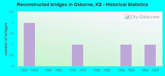
- Reconstructed bridges - Historical Statistics
- 21950-1959
- 01960-1969
- 11970-1979
- 01980-1989
- 11990-1999
- 12000-2009
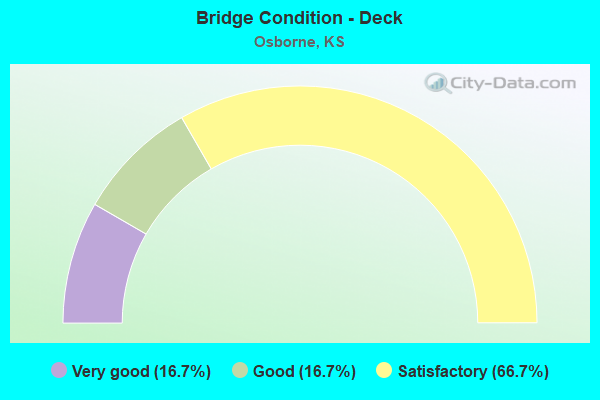
- Bridge Condition - Deck
- 16.7%Very good
- 16.7%Good
- 66.7%Satisfactory
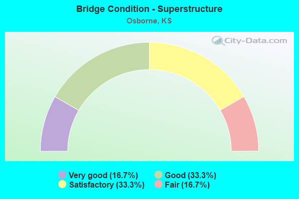
- Bridge Condition - Superstructure
- 16.7%Very good
- 33.3%Good
- 33.3%Satisfactory
- 16.7%Fair
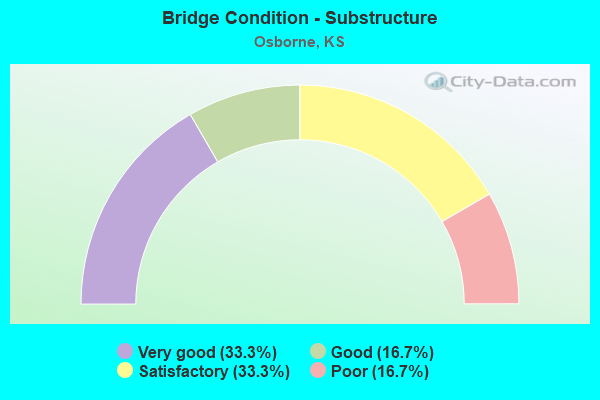
- Bridge Condition - Substructure
- 33.3%Very good
- 16.7%Good
- 33.3%Satisfactory
- 16.7%Poor
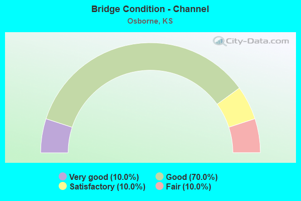
- Bridge Condition - Channel
- 10.0%Very good
- 70.0%Good
- 10.0%Satisfactory
- 10.0%Fair
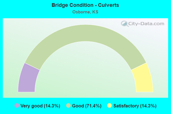
- Bridge Condition - Culverts
- 14.3%Very good
- 71.4%Good
- 14.3%Satisfactory
Find on map >> Show street view
Structure Number: 71016, Location: IN OSBORNE (Lat: 39.438150, Lng: -98.699175), Route carried "on" structure: County highway 517, Year Built: 1958, Status: Open, Structure Length: 0.77m (2.53ft), Average Daily Traffic: 435 (year 2014), Truck Traffic: 20%, Average Future Daily Traffic: 540 (year 2041), Design Load: H 20, Features Intersected: TRIB SOUTH FORK SOLOMON
Minimum Vertical Clearance: 30.47m (99.97ft), Kilometerpoint: 0.805, Lanes on structure: 2, Owner: County Highway Agency, Approaching Roadway Width: 7.3m (24.0ft), Material/Design: Concrete, Design/Construction: Culvert, Number Of Spans In Main Unit: 3, Length of Maximum Span: 2.4m (7.9ft), Curb-To-Curb Width: 8.5m (27.9ft), Out-to-Out Width: 9.0m (29.5ft)
Condition: Channel: Good, Culverts: Good, Operating Rating: 32.7 metric tons, Method Used To Determine Operating Rating: Allowable Stress (AS), Inventory Rating: 20.0 metric tons, Method Used To Determine Inventory Rating: Allowable Stress (AS), Structural Evaluation: Somewhat better than minimum adequacy, Deck Geometry: Somewhat better than minimum adequacy, Waterway Adequacy: Better than present minimum criteria, Approach Roadway Alignment: Equal to present desirable criteria, Designated Inspection Frequency: Every 24 months, Inspection Date: May 2021, Wearing Surface/Protective System: Wearing Surface: Bituminous
Find on map >> Show street view
Structure Number: 71017, Location: 1.8E OF OSBORNE (Lat: 39.438006, Lng: -98.659967), Route carried "on" structure: County highway 517, Year Built: 1958, Status: Open, Structure Length: 0.96m (3.15ft), Average Daily Traffic: 435 (year 2014), Truck Traffic: 20%, Average Future Daily Traffic: 550 (year 2041), Design Load: H 20, Features Intersected: TRIB SOUTH FORK SOLOMON
Minimum Vertical Clearance: 30.47m (99.97ft), Kilometerpoint: 2.977, Lanes on structure: 2, Owner: County Highway Agency, Approaching Roadway Width: 7.3m (24.0ft), Material/Design: Concrete, Design/Construction: Culvert, Number Of Spans In Main Unit: 3, Length of Maximum Span: 3.0m (9.8ft), Curb-To-Curb Width: 8.5m (27.9ft), Out-to-Out Width: 9.0m (29.5ft)
Condition: Channel: Satisfactory, Culverts: Good, Operating Rating: 35.4 metric tons, Method Used To Determine Operating Rating: Allowable Stress (AS), Inventory Rating: 20.9 metric tons, Method Used To Determine Inventory Rating: Allowable Stress (AS), Structural Evaluation: Equal to present minimum criteria, Deck Geometry: Somewhat better than minimum adequacy, Waterway Adequacy: Better than present minimum criteria, Approach Roadway Alignment: Equal to present desirable criteria, Designated Inspection Frequency: Every 24 months, Inspection Date: May 2021, Wearing Surface/Protective System: Wearing Surface: Bituminous
Find on map >> Show street view
Structure Number: 71036, Location: 1.0S 1.0W OF OSBORNE (Lat: 39.423817, Lng: -98.711319), Route carried "on" structure: County highway 864, Year Built: 1954, Status: Posted for load, Structure Length: 4.98m (16.34ft), Average Daily Traffic: 205 (year 2014), Truck Traffic: 20%, Average Future Daily Traffic: 220 (year 2041), Design Load: H 15, Features Intersected: COVERT CREEK
Minimum Vertical Clearance: 30.47m (99.97ft), Kilometerpoint: 27.488, Lanes on structure: 2, Owner: County Highway Agency, Approaching Roadway Width: 7.8m (25.6ft), Material/Design: Concrete continuous, Design/Construction: Slab, Number Of Spans In Main Unit: 5, Length of Maximum Span: 10.7m (35.1ft), Curb or Sidewalk Widths: Left: 0.6m (2.0ft), Right: 0.6m (2.0ft), Curb-To-Curb Width: 7.3m (24.0ft), Out-to-Out Width: 8.5m (27.9ft)
Condition: Deck: Satisfactory, Superstructure: Satisfactory, Substructure: Satisfactory, Channel: Satisfactory, Operating Rating: 22.0 metric tons, Method Used To Determine Operating Rating: Load Factor (LF), Inventory Rating: 13.2 metric tons, Method Used To Determine Inventory Rating: Load Factor (LF), Structural Evaluation: Meets minimum limits, Deck Geometry: Somewhat better than minimum adequacy, Waterway Adequacy: Equal to present desirable criteria, Approach Roadway Alignment: Equal to present desirable criteria, Bridge Posting: Required (Relationship of Operating Rating to Maximum Legal Load: 30.0 - 39.9% below), Designated Inspection Frequency: Every 24 months, Inspection Date: May 2021, Deck Structure Type: Concrete Cast-file-Place, Wearing Surface/Protective System: Wearing Surface: Monolithic Concrete
Find on map >> Show street view
Structure Number: 710667003749, Location: 0.1S 1.3E OF BLOOMINGTON (Lat: 39.453539, Lng: -98.768911), Route carried "on" structure: County highway , Year Built: 1964, Status: Open, Structure Length: 0.86m (2.82ft), Average Daily Traffic: 25 (year 2014), Average Future Daily Traffic: 25 (year 2041), Design Load: H 20, Features Intersected: TRIB SOUTH FORK SOLOMON, Facility Carried by Structure: S. 150th AVE.
Minimum Vertical Clearance: 30.47m (99.97ft), Kilometerpoint: 0.000, Lanes on structure: 2, Owner: County Highway Agency, Approaching Roadway Width: 8.5m (27.9ft), Material/Design: Concrete, Design/Construction: Culvert, Number Of Spans In Main Unit: 3, Length of Maximum Span: 2.7m (8.9ft), Curb-To-Curb Width: 8.7m (28.5ft), Out-to-Out Width: 9.1m (29.9ft)
Condition: Channel: Good, Culverts: Good, Operating Rating: 35.4 metric tons, Method Used To Determine Operating Rating: Allowable Stress (AS), Inventory Rating: 20.9 metric tons, Method Used To Determine Inventory Rating: Allowable Stress (AS), Structural Evaluation: Equal to present minimum criteria, Deck Geometry: Better than present minimum criteria, Waterway Adequacy: Equal to present minimum criteria, Approach Roadway Alignment: Equal to present desirable criteria, Designated Inspection Frequency: Every 24 months, Inspection Date: May 2021, Wearing Surface/Protective System: Wearing Surface: Gravel
Find on map >> Show street view
Structure Number: 71066700376, Location: 0.2S 1.3E OF BLOOMINGTON (Lat: 39.452522, Lng: -98.769417), Route carried "on" structure: County highway , Year Built: 1954, Status: Open, Structure Length: 2.16m (7.09ft), Average Daily Traffic: 5 (year 2014), Average Future Daily Traffic: 10 (year 2041), Design Load: H 20, Features Intersected: TRIB SOUTH FORK SOLOMON, Facility Carried by Structure: W. 80th DR.
Minimum Vertical Clearance: 30.47m (99.97ft), Kilometerpoint: 0.000, Lanes on structure: 2, Owner: County Highway Agency, Approaching Roadway Width: 7.3m (24.0ft), Material/Design: Concrete, Design/Construction: Culvert, Number Of Spans In Main Unit: 8, Length of Maximum Span: 2.4m (7.9ft), Curb-To-Curb Width: 9.1m (29.9ft), Out-to-Out Width: 9.9m (32.5ft)
Condition: Channel: Good, Culverts: Satisfactory, Operating Rating: 32.7 metric tons, Method Used To Determine Operating Rating: Field evaluation and documented engineering judgment, Inventory Rating: 32.7 metric tons, Method Used To Determine Inventory Rating: Field evaluation and documented engineering judgment, Structural Evaluation: Equal to present minimum criteria, Deck Geometry: Better than present minimum criteria, Waterway Adequacy: Equal to present desirable criteria, Approach Roadway Alignment: Equal to present desirable criteria, Designated Inspection Frequency: Every 24 months, Inspection Date: May 2021, Other Special Inspection Date: October 2021, Wearing Surface/Protective System: Wearing Surface: Bituminous
Find on map >> Show street view
Structure Number: 710671003861, Location: 4.1S 2.0W OF OSBORNE (Lat: 39.378517, Lng: -98.731556), Route carried "on" structure: County highway 7109, Year Built: 1969, Status: Posted for load, Structure Length: 3.66m (12.01ft), Average Daily Traffic: 60 (year 2014), Average Future Daily Traffic: 70 (year 2041), Design Load: H 15, Features Intersected: TRIB TO COVERT CREEK, Facility Carried by Structure: S. 130th AVE.
Minimum Vertical Clearance: 30.47m (99.97ft), Kilometerpoint: 0.000, Lanes on structure: 2, Owner: County Highway Agency, Approaching Roadway Width: 8.5m (27.9ft), Material/Design: Concrete continuous, Design/Construction: Tee Beam, Number Of Spans In Main Unit: 3, Length of Maximum Span: 13.7m (44.9ft), Curb-To-Curb Width: 8.5m (27.9ft), Out-to-Out Width: 9.1m (29.9ft)
Condition: Deck: Satisfactory, Superstructure: Good, Substructure: Good, Channel: Good, Operating Rating: 33.1 metric tons, Method Used To Determine Operating Rating: Load Factor (LF), Inventory Rating: 19.8 metric tons, Method Used To Determine Inventory Rating: Load Factor (LF), Structural Evaluation: Somewhat better than minimum adequacy, Deck Geometry: Better than present minimum criteria, Waterway Adequacy: Equal to present desirable criteria, Approach Roadway Alignment: Equal to present desirable criteria, Designated Inspection Frequency: Every 24 months, Inspection Date: May 2021, Deck Structure Type: Concrete Cast-file-Place, Wearing Surface/Protective System: Wearing Surface: Integral Concrete
Find on map >> Show street view
Structure Number: 710673003766, Location: 0.1N OF OSBORNE (Lat: 39.444397, Lng: -98.712894), Route carried "on" structure: County highway 7111, Year Built: 1958, Status: Posted for load, Structure Length: 1.13m (3.71ft), Average Daily Traffic: 50 (year 2014), Average Future Daily Traffic: 50 (year 2041), Design Load: H 20, Features Intersected: DRAINAGE DITCH, Facility Carried by Structure: S. 120th AVE.
Minimum Vertical Clearance: 30.47m (99.97ft), Kilometerpoint: 0.000, Lanes on structure: 2, Owner: County Highway Agency, Approaching Roadway Width: 6.7m (22.0ft), Material/Design: Wood or Timber, Design/Construction: Stringer/Multi-beam, Number Of Spans In Main Unit: 3, Length of Maximum Span: 4.6m (15.1ft), Curb-To-Curb Width: 5.9m (19.4ft), Out-to-Out Width: 6.2m (20.3ft)
Condition: Deck: Satisfactory, Superstructure: Fair, Substructure: Poor, Channel: Good, Operating Rating: 16.9 metric tons, Method Used To Determine Operating Rating: Load Factor (LF), Inventory Rating: 10.3 metric tons, Method Used To Determine Inventory Rating: Load Factor (LF), Structural Evaluation: High priority of replacement, Deck Geometry: Meets minimum limits, Waterway Adequacy: Better than present minimum criteria, Approach Roadway Alignment: Equal to present desirable criteria, Bridge Posting: Required (Relationship of Operating Rating to Maximum Legal Load: 30.0 - 39.9% below), Length Of Structure Improvement: 0.91m (2.99ft), Designated Inspection Frequency: Every 24 months, Inspection Date: May 2021, Bridge Improvement Cost: $100,000, Roadway Improvement Cost: $20,000, Total Project Cost: $150,000, Deck Structure Type: Corrugated Steel, Wearing Surface/Protective System: Wearing Surface: Gravel
Find on map >> Show street view
Structure Number: 710673503762, Location: 0.2N OF OSBORNE (Lat: 39.449408, Lng: -98.703867), Route carried "on" structure: County highway , Year Built: 1979, Status: Open, Structure Length: 0.77m (2.53ft), Average Daily Traffic: 50 (year 2014), Average Future Daily Traffic: 50 (year 2041), Design Load: H 20, Features Intersected: DRAINAGE DITCH, Facility Carried by Structure: S. 115th AVE.
Minimum Vertical Clearance: 30.47m (99.97ft), Kilometerpoint: 0.000, Lanes on structure: 2, Owner: County Highway Agency, Approaching Roadway Width: 6.4m (21.0ft), Material/Design: Concrete, Design/Construction: Culvert, Number Of Spans In Main Unit: 3, Length of Maximum Span: 2.4m (7.9ft), Curb-To-Curb Width: 8.5m (27.9ft), Out-to-Out Width: 9.0m (29.5ft)
Condition: Channel: Good, Culverts: Good, Operating Rating: 32.7 metric tons, Method Used To Determine Operating Rating: Field evaluation and documented engineering judgment, Inventory Rating: 32.7 metric tons, Method Used To Determine Inventory Rating: Field evaluation and documented engineering judgment, Structural Evaluation: Better than present minimum criteria, Deck Geometry: Better than present minimum criteria, Waterway Adequacy: Equal to present desirable criteria, Approach Roadway Alignment: Equal to present desirable criteria, Designated Inspection Frequency: Every 24 months, Inspection Date: May 2021, Other Special Inspection Date: October 2021, Wearing Surface/Protective System: Wearing Surface: Gravel
Find on map >> Show street view
Structure Number: 710679003781, Location: 0.1S 2.0E OF OSBORNE (Lat: 39.436606, Lng: -98.657267), Route carried "on" structure: County highway , Year Built: 1964, Year Reconstructed: 1975, Status: Open, Structure Length: 0.98m (3.22ft), Average Daily Traffic: 50 (year 2014), Average Future Daily Traffic: 50 (year 2041), Design Load: H 15, Features Intersected: TRIB. SOUTH FORK SOLOMON, Facility Carried by Structure: S. 90th AVE.
Minimum Vertical Clearance: 30.47m (99.97ft), Kilometerpoint: 0.000, Lanes on structure: 2, Owner: County Highway Agency, Approaching Roadway Width: 7.3m (24.0ft), Skew: 3 degrees, Material/Design: Steel continuous, Design/Construction: Stringer/Multi-beam, Number Of Spans In Main Unit: 2, Length of Maximum Span: 4.9m (16.1ft), Curb-To-Curb Width: 6.7m (22.0ft), Out-to-Out Width: 6.7m (22.0ft)
Condition: Deck: Satisfactory, Superstructure: Satisfactory, Substructure: Satisfactory, Channel: Fair, Operating Rating: 36.3 metric tons, Method Used To Determine Operating Rating: Load Factor (LF), Inventory Rating: 21.8 metric tons, Method Used To Determine Inventory Rating: Load Factor (LF), Structural Evaluation: Equal to present minimum criteria, Deck Geometry: Somewhat better than minimum adequacy, Waterway Adequacy: Equal to present desirable criteria, Approach Roadway Alignment: Equal to present desirable criteria, Designated Inspection Frequency: Every 24 months, Inspection Date: May 2021, Deck Structure Type: Wood or Timber, Wearing Surface/Protective System: Wearing Surface: Gravel
Find on map >> Show street view
Structure Number: 710679003787, Location: 0.8S 2.0E OF OSBORNE (Lat: 39.427808, Lng: -98.657686), Route carried "on" structure: County highway 1085, Year Built: 2018, Status: Open, Structure Length: 5.59m (18.34ft), Average Daily Traffic: 30 (year 2014), Average Future Daily Traffic: 30 (year 2041), Design Load: HL 93, Features Intersected: SOUTH FORK SOLOMON RIVER, Facility Carried by Structure: S 90th AVE
Minimum Vertical Clearance: 30.47m (99.97ft), Kilometerpoint: 0.000, Lanes on structure: 2, Owner: County Highway Agency, Approaching Roadway Width: 8.5m (27.9ft), Skew: 4 degrees, Material/Design: Concrete continuous, Design/Construction: Slab, Number Of Spans In Main Unit: 3, Length of Maximum Span: 21.9m (71.9ft), Curb or Sidewalk Widths: Left: 0.3m (1.0ft), Right: 0.3m (1.0ft), Curb-To-Curb Width: 8.5m (27.9ft), Out-to-Out Width: 9.1m (29.9ft)
Condition: Deck: Very good, Superstructure: Very good, Substructure: Very good, Channel: Good, Operating Rating: 56.7 metric tons, Method Used To Determine Operating Rating: Load and Resistance Factor Rating (LRFR) rating reported by rating factor(RF) method using HL-93 loadings, Inventory Rating: 43.7 metric tons, Method Used To Determine Inventory Rating: Load and Resistance Factor Rating (LRFR) rating reported by rating factor(RF) method using HL-93 loadings, Structural Evaluation: Equal to present desirable criteria, Deck Geometry: Better than present minimum criteria, Waterway Adequacy: Equal to present minimum criteria, Approach Roadway Alignment: Equal to present desirable criteria, Designated Inspection Frequency: Every 24 months, Inspection Date: May 2021, Deck Structure Type: Concrete Cast-file-Place, Wearing Surface/Protective System: Wearing Surface: Monolithic Concrete
Find on map >> Show street view
Structure Number: 999902400710111, Location: 3.99 M W JCT 281,SDRD RT (Lat: 39.452500, Lng: -98.769167), Route carried "on" structure: ServiceCounty highway 186, Year Built: 1931, Status: Open, Structure Length: 2.16m (7.09ft), Average Daily Traffic: 12 (year 2020), Average Future Daily Traffic: 956 (year 2041), Design Load: H 15, Features Intersected: U24 DRAINAGE, Facility Carried by Structure: W 80 TH DR (LEFT)
Minimum Vertical Clearance: 30.47m (99.97ft), Kilometerpoint: 0.042, Lanes on structure: 2, Owner: State Highway Agency, Approaching Roadway Width: 7.3m (24.0ft), Material/Design: Concrete, Design/Construction: Culvert, Number Of Spans In Main Unit: 8, Length of Maximum Span: 2.4m (7.9ft), Curb-To-Curb Width: 9.1m (29.9ft), Out-to-Out Width: 9.9m (32.5ft)
Condition: Channel: Good, Culverts: Good, Operating Rating: 33.3 metric tons, Method Used To Determine Operating Rating: Load Factor (LF), Inventory Rating: 20.0 metric tons, Method Used To Determine Inventory Rating: Load Factor (LF), Structural Evaluation: Somewhat better than minimum adequacy, Deck Geometry: Better than present minimum criteria, Waterway Adequacy: Better than present minimum criteria, Approach Roadway Alignment: Somewhat better than minimum adequacy, Length Of Structure Improvement: 7.08m (23.23ft), Designated Inspection Frequency: Every 24 months, Inspection Date: March 2021, Deck Structure Type: Concrete Cast-file-Place, Wearing Surface/Protective System: Wearing Surface: Bituminous
Find on map >> Show street view
Structure Number: 999902400710121, Location: 03.98 MI W SJCT U281 (Lat: 39.452778, Lng: -98.769167), Route carried "on" structure: US 24, Year Built: 1962, Year Reconstructed: 2009, Status: Open, Structure Length: 1.94m (6.36ft), Average Daily Traffic: 1,185 (year 2020), Truck Traffic: 10%, Average Future Daily Traffic: 1,309 (year 2041), Design Load: H 20, Features Intersected: S F SOLOMON R DRAIN
Minimum Vertical Clearance: 30.47m (99.97ft), Kilometerpoint: 24.425, Lanes on structure: 2, Base Highway Network: Yes, Owner: State Highway Agency, Approaching Roadway Width: 9.1m (29.9ft), Material/Design: Concrete, Design/Construction: Culvert, Number Of Spans In Main Unit: 6, Length of Maximum Span: 3.0m (9.8ft), Curb-To-Curb Width: 14.8m (48.6ft), Out-to-Out Width: 15.2m (49.9ft)
Condition: Channel: Very good, Culverts: Satisfactory, Operating Rating: 29.8 metric tons, Method Used To Determine Operating Rating: Load Factor (LF), Inventory Rating: 17.9 metric tons, Method Used To Determine Inventory Rating: Load Factor (LF), Structural Evaluation: Meets minimum limits, Deck Geometry: Superior to present desirable criteria, Waterway Adequacy: Equal to present desirable criteria, Approach Roadway Alignment: Better than present minimum criteria, Length Of Structure Improvement: 6.36m (20.87ft), Designated Inspection Frequency: Every 24 months, Inspection Date: March 2021, Deck Structure Type: Concrete Cast-file-Place, Wearing Surface/Protective System: Wearing Surface: Bituminous
Find on map >> Show street view
Structure Number: 999902400710131, Location: 03.97MI W SJT U281,SDRD N (Lat: 39.453333, Lng: -98.768889), Route carried "on" structure: ServiceCounty highway 35, Year Built: 1962, Status: Open, Structure Length: 0.86m (2.82ft), Average Daily Traffic: 12 (year 2020), Average Future Daily Traffic: 956 (year 2041), Design Load: H 20, Features Intersected: U24 DRAINAGE, Facility Carried by Structure: S. 150TH AVE
Minimum Vertical Clearance: 30.47m (99.97ft), Kilometerpoint: 7.656, Lanes on structure: 2, Owner: State Highway Agency, Approaching Roadway Width: 7.3m (24.0ft), Material/Design: Concrete, Design/Construction: Culvert, Number Of Spans In Main Unit: 3, Length of Maximum Span: 2.7m (8.9ft), Curb-To-Curb Width: 8.5m (27.9ft), Out-to-Out Width: 9.0m (29.5ft)
Condition: Channel: Good, Culverts: Good, Operating Rating: 28.5 metric tons, Method Used To Determine Operating Rating: Load Factor (LF), Inventory Rating: 17.1 metric tons, Method Used To Determine Inventory Rating: Load Factor (LF), Structural Evaluation: Somewhat better than minimum adequacy, Deck Geometry: Better than present minimum criteria, Waterway Adequacy: Equal to present desirable criteria, Approach Roadway Alignment: Somewhat better than minimum adequacy, Length Of Structure Improvement: 2.82m (9.25ft), Designated Inspection Frequency: Every 24 months, Inspection Date: March 2021, Deck Structure Type: Concrete Cast-file-Place, Wearing Surface/Protective System: Wearing Surface: Gravel
Find on map >> Show street view
Structure Number: 999902400710141, Location: 02.94MI W SJCT U281 (Lat: 39.452778, Lng: -98.749722), Route carried "on" structure: US 24, Year Built: 1962, Status: Open, Structure Length: 0.63m (2.07ft), Average Daily Traffic: 1,185 (year 2020), Truck Traffic: 10%, Average Future Daily Traffic: 1,309 (year 2041), Design Load: H 20, Features Intersected: S F SOLOMON R DRAIN
Minimum Vertical Clearance: 30.47m (99.97ft), Kilometerpoint: 26.113, Lanes on structure: 2, Base Highway Network: Yes, Owner: State Highway Agency, Approaching Roadway Width: 9.1m (29.9ft), Material/Design: Concrete, Design/Construction: Culvert, Number Of Spans In Main Unit: 2, Length of Maximum Span: 3.0m (9.8ft), Curb-To-Curb Width: 14.6m (47.9ft), Out-to-Out Width: 15.1m (49.5ft)
Condition: Channel: Good, Culverts: Good, Operating Rating: 32.6 metric tons, Method Used To Determine Operating Rating: Load Factor (LF), Inventory Rating: 19.5 metric tons, Method Used To Determine Inventory Rating: Load Factor (LF), Structural Evaluation: Somewhat better than minimum adequacy, Deck Geometry: Superior to present desirable criteria, Waterway Adequacy: Equal to present desirable criteria, Approach Roadway Alignment: Better than present minimum criteria, Length Of Structure Improvement: 2.05m (6.73ft), Designated Inspection Frequency: Every 24 months, Inspection Date: March 2021, Deck Structure Type: Concrete Cast-file-Place, Wearing Surface/Protective System: Wearing Surface: Bituminous
Find on map >> Show street view
Structure Number: 999902400710151, Location: 02.05MI W SJCT U281 (Lat: 39.452778, Lng: -98.732778), Route carried "on" structure: US 24, Year Built: 1962, Status: Open, Structure Length: 0.94m (3.08ft), Average Daily Traffic: 1,185 (year 2020), Truck Traffic: 10%, Average Future Daily Traffic: 1,309 (year 2041), Design Load: H 20, Features Intersected: S F SOLOMON R DRAIN
Minimum Vertical Clearance: 30.47m (99.97ft), Kilometerpoint: 27.558, Lanes on structure: 2, Base Highway Network: Yes, Owner: State Highway Agency, Approaching Roadway Width: 9.1m (29.9ft), Material/Design: Concrete, Design/Construction: Culvert, Number Of Spans In Main Unit: 3, Length of Maximum Span: 3.0m (9.8ft), Curb-To-Curb Width: 14.6m (47.9ft), Out-to-Out Width: 15.1m (49.5ft)
Condition: Channel: Very good, Culverts: Good, Operating Rating: 30.2 metric tons, Method Used To Determine Operating Rating: Load Factor (LF), Inventory Rating: 18.1 metric tons, Method Used To Determine Inventory Rating: Load Factor (LF), Structural Evaluation: Somewhat better than minimum adequacy, Deck Geometry: Superior to present desirable criteria, Waterway Adequacy: Equal to present desirable criteria, Approach Roadway Alignment: Better than present minimum criteria, Length Of Structure Improvement: 3.10m (10.17ft), Designated Inspection Frequency: Every 24 months, Inspection Date: March 2021, Deck Structure Type: Concrete Cast-file-Place, Wearing Surface/Protective System: Wearing Surface: Bituminous
Find on map >> Show street view
Structure Number: 999902400710161, Location: 0.86 MI W SJCT US281 (Lat: 39.452778, Lng: -98.710833), Route carried "on" structure: US 24, Year Built: 1931, Year Reconstructed: 1962, Status: Open, Structure Length: 0.68m (2.23ft), Average Daily Traffic: 1,378 (year 2020), Truck Traffic: 9%, Average Future Daily Traffic: 1,523 (year 2041), Design Load: H 20, Features Intersected: S F SOLOMON R DRAIN
Minimum Vertical Clearance: 30.47m (99.97ft), Kilometerpoint: 29.462, Lanes on structure: 2, Base Highway Network: Yes, Owner: State Highway Agency, Approaching Roadway Width: 9.1m (29.9ft), Material/Design: Concrete, Design/Construction: Culvert, Number Of Spans In Main Unit: 3, Length of Maximum Span: 2.1m (6.9ft), Curb-To-Curb Width: 13.4m (44.0ft), Out-to-Out Width: 32.1m (105.3ft)
Condition: Channel: Good, Culverts: Good, Operating Rating: 40.5 metric tons, Method Used To Determine Operating Rating: Load Factor (LF), Inventory Rating: 24.2 metric tons, Method Used To Determine Inventory Rating: Load Factor (LF), Structural Evaluation: Equal to present minimum criteria, Deck Geometry: Equal to present desirable criteria, Waterway Adequacy: Somewhat better than minimum adequacy, Approach Roadway Alignment: Better than present minimum criteria, Length Of Structure Improvement: 2.24m (7.35ft), Designated Inspection Frequency: Every 24 months, Inspection Date: March 2021, Deck Structure Type: Concrete Cast-file-Place, Wearing Surface/Protective System: Wearing Surface: Bituminous
Find on map >> Show street view
Structure Number: 999902400710171, Location: 0.62MI W SJCT U281 (Lat: 39.452778, Lng: -98.706389), Route carried "on" structure: US 24, Year Built: 1931, Year Reconstructed: 1962, Status: Open, Structure Length: 0.87m (2.85ft), Average Daily Traffic: 1,378 (year 2020), Truck Traffic: 9%, Average Future Daily Traffic: 1,523 (year 2041), Design Load: H 20, Features Intersected: S F SOLOMON R DRAIN
Minimum Vertical Clearance: 30.47m (99.97ft), Kilometerpoint: 29.849, Lanes on structure: 2, Base Highway Network: Yes, Owner: State Highway Agency, Approaching Roadway Width: 9.1m (29.9ft), Material/Design: Concrete, Design/Construction: Culvert, Number Of Spans In Main Unit: 3, Length of Maximum Span: 2.7m (8.9ft), Curb-To-Curb Width: 13.4m (44.0ft), Out-to-Out Width: 34.8m (114.2ft)
Condition: Channel: Good, Culverts: Good, Operating Rating: 37.0 metric tons, Method Used To Determine Operating Rating: Load Factor (LF), Inventory Rating: 22.1 metric tons, Method Used To Determine Inventory Rating: Load Factor (LF), Structural Evaluation: Somewhat better than minimum adequacy, Deck Geometry: Equal to present desirable criteria, Waterway Adequacy: Better than present minimum criteria, Approach Roadway Alignment: Better than present minimum criteria, Length Of Structure Improvement: 2.86m (9.38ft), Designated Inspection Frequency: Every 24 months, Inspection Date: March 2021, Deck Structure Type: Concrete Cast-file-Place, Wearing Surface/Protective System: Wearing Surface: Bituminous
Find on map >> Show street view
Structure Number: 999928100710331, Location: 1.44MI S SJCT U24 (Lat: 39.431667, Lng: -98.694722), Route carried "on" structure: US 281, Year Built: 1935, Year Reconstructed: 1990, Status: Open, Structure Length: 0.77m (2.53ft), Average Daily Traffic: 1,015 (year 2020), Truck Traffic: 21%, Average Future Daily Traffic: 1,015 (year 2041), Design Load: H 15, Features Intersected: S F SOLOMON R DRAIN
Minimum Vertical Clearance: 30.47m (99.97ft), Kilometerpoint: 33.151, Lanes on structure: 2, Base Highway Network: Yes, Owner: State Highway Agency, Approaching Roadway Width: 9.1m (29.9ft), Material/Design: Concrete, Design/Construction: Culvert, Number Of Spans In Main Unit: 2, Length of Maximum Span: 3.7m (12.1ft), Curb-To-Curb Width: 9.1m (29.9ft), Out-to-Out Width: 21.3m (69.9ft)
Condition: Channel: Fair, Culverts: Very good, Operating Rating: 62.6 metric tons, Method Used To Determine Operating Rating: Load Factor (LF), Inventory Rating: 37.2 metric tons, Method Used To Determine Inventory Rating: Load Factor (LF), Structural Evaluation: Equal to present desirable criteria, Deck Geometry: Somewhat better than minimum adequacy, Waterway Adequacy: Better than present minimum criteria, Approach Roadway Alignment: Meets minimum limits, Length Of Structure Improvement: 2.51m (8.23ft), Designated Inspection Frequency: Every 24 months, Inspection Date: March 2021, Deck Structure Type: Concrete Cast-file-Place, Wearing Surface/Protective System: Wearing Surface: Monolithic Concrete
Find on map >> Show street view
Structure Number: 999928100710341, Location: 0.18MI S SJCT U24 (Lat: 39.450000, Lng: -98.694444), Route carried "on" structure: US 281, Year Built: 1950, Status: Open, Structure Length: 0.78m (2.56ft), Average Daily Traffic: 2,305 (year 2020), Truck Traffic: 14%, Average Future Daily Traffic: 2,305 (year 2041), Design Load: H 20, Features Intersected: OSBORNE CANAL DRAINAGE
Minimum Vertical Clearance: 30.47m (99.97ft), Kilometerpoint: 35.188, Lanes on structure: 2, Base Highway Network: Yes, Owner: State Highway Agency, Approaching Roadway Width: 7.3m (24.0ft), Material/Design: Concrete, Design/Construction: Culvert, Number Of Spans In Main Unit: 3, Length of Maximum Span: 2.4m (7.9ft), Curb-To-Curb Width: 12.8m (42.0ft), Out-to-Out Width: 13.6m (44.6ft)
Condition: Channel: Good, Culverts: Very good, Operating Rating: 33.3 metric tons, Method Used To Determine Operating Rating: Load Factor (LF), Inventory Rating: 20.0 metric tons, Method Used To Determine Inventory Rating: Load Factor (LF), Structural Evaluation: Somewhat better than minimum adequacy, Deck Geometry: Equal to present minimum criteria, Waterway Adequacy: Equal to present desirable criteria, Approach Roadway Alignment: Meets minimum limits, Length Of Structure Improvement: 2.55m (8.37ft), Designated Inspection Frequency: Every 24 months, Inspection Date: March 2021, Deck Structure Type: Concrete Cast-file-Place, Wearing Surface/Protective System: Wearing Surface: Bituminous
Find on map >> Show street view
Structure Number: 999928100710511, Location: 1.72 MI S SJCT U24 (Lat: 39.428333, Lng: -98.694722), Route carried "on" structure: US 281, Year Built: 2004, Status: Open, Structure Length: 19.19m (62.96ft), Average Daily Traffic: 1,015 (year 2020), Truck Traffic: 21%, Average Future Daily Traffic: 1,015 (year 2041), Design Load: HS 20, Features Intersected: SOUTH FORK SOLOMON RIVER
Minimum Vertical Clearance: 30.47m (99.97ft), Kilometerpoint: 32.753, Lanes on structure: 2, Base Highway Network: Yes, Owner: State Highway Agency, Approaching Roadway Width: 11.0m (36.1ft), Material/Design: Prestressed concrete continuous, Design/Construction: Stringer/Multi-beam, Number Of Spans In Main Unit: 6, Length of Maximum Span: 31.8m (104.3ft), Curb-To-Curb Width: 11.0m (36.1ft), Out-to-Out Width: 11.6m (38.1ft)
Condition: Deck: Good, Superstructure: Good, Substructure: Very good, Channel: Good, Operating Rating: 43.4 metric tons, Method Used To Determine Operating Rating: Load and Resistance Factor Rating (LRFR) rating reported by rating factor(RF) method using HL-93 loadings, Inventory Rating: 27.2 metric tons, Method Used To Determine Inventory Rating: Load and Resistance Factor Rating (LRFR) rating reported by rating factor(RF) method using HL-93 loadings, Structural Evaluation: Equal to present minimum criteria, Deck Geometry: Equal to present minimum criteria, Waterway Adequacy: Better than present minimum criteria, Approach Roadway Alignment: Better than present minimum criteria, Length Of Structure Improvement: 62.94m (206.50ft), Designated Inspection Frequency: Every 24 months, Inspection Date: March 2021, Wearing Surface/Protective System: Wearing Surface: Low Slump Concrete, Deck Protection: Epoxy Coated Reinforcing