Bridge Statistics for Ossining, New York (NY)
Condition, Traffic, Stress, Structural Evaluation, Project Costs
- National Bridge Inventory (NBI) Statistics
- 23Number of bridges
- 161ft / 48.8mTotal length
- $48,707,000Total costs
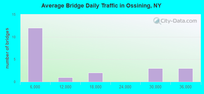
- 222,516Total average daily traffic
- 6,521Total average daily truck traffic
- National Bridge Inventory (NBI) Registered Bridges for Ossining
- No street view available for this location
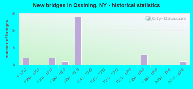
- New bridges - historical statistics
- 2Before 1900
- 21910-1919
- 11920-1929
- 141930-1939
- 31980-1989
- 12010-2019
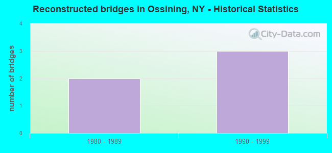
- Reconstructed bridges - Historical Statistics
- 21980-1989
- 31990-1999
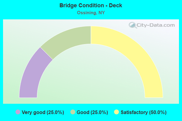
- Bridge Condition - Deck
- 25.0%Very good
- 25.0%Good
- 50.0%Satisfactory
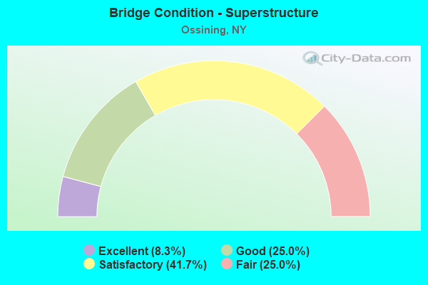
- Bridge Condition - Superstructure
- 8.3%Excellent
- 25.0%Good
- 41.7%Satisfactory
- 25.0%Fair
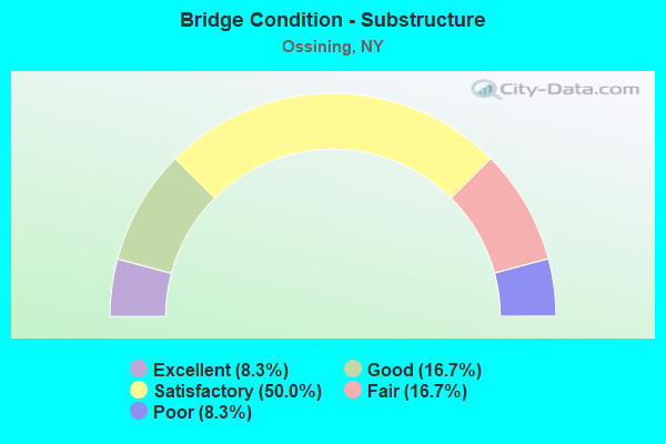
- Bridge Condition - Substructure
- 8.3%Excellent
- 16.7%Good
- 50.0%Satisfactory
- 16.7%Fair
- 8.3%Poor
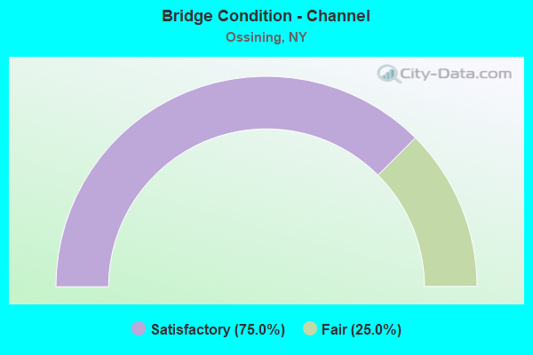
- Bridge Condition - Channel
- 75.0%Satisfactory
- 25.0%Fair
Find on map >> Show street view
Structure Number: 100495, Location: 0.2 MI N JCT RTS 9 & 133 (Lat: 41.165106, Lng: -73.861539), Route carried "on" structure: US 9, Year Built: 1983, Status: Open, Structure Length: 0.85m (2.79ft), Average Daily Traffic: 12,907 (year 2018), Truck Traffic: 4%, Average Future Daily Traffic: 12,967 (year 2040), Design Load: HS 20, Features Intersected: SING SING CREEK
Minimum Vertical Clearance: 30+ m (98+ ft), Kilometerpoint: 29.638, Lanes on structure: 4, Owner: State Highway Agency, Approaching Roadway Width: 14.6m (47.9ft), Skew: 4 degrees, Material/Design: Concrete continuous, Design/Construction: Culvert, Number Of Spans In Main Unit: 2, Length of Maximum Span: 3.6m (11.8ft), Curb or Sidewalk Widths: Left: 1.5m (4.9ft), Right: 1.5m (4.9ft), Curb-To-Curb Width: 13.4m (44.0ft), Out-to-Out Width: 16.2m (53.1ft)
Condition: Channel: Fair, Culverts: Good, Operating Rating: 75.1 metric tons, Method Used To Determine Operating Rating: Field evaluation and documented engineering judgment, Inventory Rating: 32.7 metric tons, Method Used To Determine Inventory Rating: Field evaluation and documented engineering judgment, Structural Evaluation: Better than present minimum criteria, Deck Geometry: High priority of replacement, Waterway Adequacy: Equal to present desirable criteria, Approach Roadway Alignment: Equal to present desirable criteria, Length Of Structure Improvement: 0.85m (2.79ft), Designated Inspection Frequency: Every 24 months, Inspection Date: April 2020, Bridge Improvement Cost: $388,000, Roadway Improvement Cost: $227,000, Total Project Cost: $616,000 ( Estimate for 2021), Wearing Surface/Protective System: Wearing Surface: Bituminous
Find on map >> Show street view
Structure Number: 100496, Location: 1.6 MI S JCT RTS 9+129 (Lat: 41.184950, Lng: -73.871358), Route carried "on" structure: US 9, Year Built: 1933, Status: Open, Structure Length: 2.29m (7.51ft), Average Daily Traffic: 12,907 (year 2018), Truck Traffic: 4%, Average Future Daily Traffic: 12,967 (year 2040), Features Intersected: RTE 9A
Minimum Vertical Clearance: 30+ m (98+ ft), Kilometerpoint: 32.035, Lanes on structure: 2, Lanes under structure: 2, Base Highway Network: Yes, Owner: State Highway Agency, Approaching Roadway Width: 11.0m (36.1ft), Skew: 4 degrees, Material/Design: Concrete, Design/Construction: Frame, Number Of Spans In Main Unit: 1, Length of Maximum Span: 17.0m (55.8ft), Curb or Sidewalk Widths: Left: 1.2m (3.9ft), Right: 0.6m (2.0ft), Curb-To-Curb Width: 11.0m (36.1ft), Out-to-Out Width: 14.9m (48.9ft)
Condition: Superstructure: Satisfactory, Substructure: Satisfactory, Operating Rating: 55.8 metric tons, Method Used To Determine Operating Rating: Field evaluation and documented engineering judgment, Inventory Rating: 22.4 metric tons, Method Used To Determine Inventory Rating: Field evaluation and documented engineering judgment, Structural Evaluation: Somewhat better than minimum adequacy, Deck Geometry: Meets minimum limits, Underclear: High priority of corrective action, Approach Roadway Alignment: Meets minimum limits, Length Of Structure Improvement: 2.28m (7.48ft), Designated Inspection Frequency: Every 24 months, Inspection Date: December 2020, Bridge Improvement Cost: $2,097,000, Roadway Improvement Cost: $1,228,000, Total Project Cost: $3,325,000 ( Estimate for 2021)
Find on map >> Show street view
Structure Number: 100619, Location: JCT SH 9A & SH 133 (Lat: 41.168283, Lng: -73.838514), Route carried "on" structure: State highway 9A, Year Built: 1932, Year Reconstructed: 2001, Status: Open, Structure Length: 2.04m (6.69ft), Average Daily Traffic: 27,452 (year 2011), Truck Traffic: 6%, Average Future Daily Traffic: 27,581 (year 2040), Features Intersected: RTE 133
Minimum Vertical Clearance: 30+ m (98+ ft), Kilometerpoint: 33.419, Lanes on structure: 4, Lanes under structure: 2, Base Highway Network: Yes, Owner: State Highway Agency, Approaching Roadway Width: 14.6m (47.9ft), Skew: 20 degrees, Material/Design: Concrete, Design/Construction: Frame, Number Of Spans In Main Unit: 1, Length of Maximum Span: 17.3m (56.8ft), Curb-To-Curb Width: 13.7m (44.9ft), Out-to-Out Width: 15.2m (49.9ft)
Condition: Superstructure: Satisfactory, Substructure: Satisfactory, Operating Rating: 55.7 metric tons, Method Used To Determine Operating Rating: Field evaluation and documented engineering judgment, Inventory Rating: 22.3 metric tons, Method Used To Determine Inventory Rating: Field evaluation and documented engineering judgment, Structural Evaluation: Somewhat better than minimum adequacy, Deck Geometry: High priority of replacement, Underclear: Equal to present minimum criteria, Approach Roadway Alignment: Meets minimum limits, Length Of Structure Improvement: 2.04m (6.69ft), Designated Inspection Frequency: Every 24 months, Inspection Date: April 2020, Bridge Improvement Cost: $1,773,000, Roadway Improvement Cost: $1,038,000, Total Project Cost: $2,811,000 ( Estimate for 2021)
Find on map >> Show street view
Structure Number: 10062, Location: .2 MI N JCT SH 9A & SH133 (Lat: 41.171753, Lng: -73.839858), Route carried "on" structure: Other road , Year Built: 1932, Year Reconstructed: 2001, Status: Open, Structure Length: 1.74m (5.71ft), Average Daily Traffic: 2,510 (year 2017), Truck Traffic: 4%, Average Future Daily Traffic: 3,105 (year 2040), Features Intersected: 9A 9A87032152 SB, RTE, Facility Carried by Structure: RYDER ROAD
Minimum Vertical Clearance: 30+ m (98+ ft), Kilometerpoint: 0.064, Lanes on structure: 2, Lanes under structure: 4, Owner: State Highway Agency, Approaching Roadway Width: 11.0m (36.1ft), Skew: 1 degrees, Material/Design: Concrete, Design/Construction: Frame, Number Of Spans In Main Unit: 1, Length of Maximum Span: 14.0m (45.9ft), Curb-To-Curb Width: 11.6m (38.1ft), Out-to-Out Width: 18.1m (59.4ft)
Condition: Superstructure: Fair, Substructure: Satisfactory, Operating Rating: 57.1 metric tons, Method Used To Determine Operating Rating: Field evaluation and documented engineering judgment, Inventory Rating: 21.4 metric tons, Method Used To Determine Inventory Rating: Field evaluation and documented engineering judgment, Structural Evaluation: Somewhat better than minimum adequacy, Deck Geometry: Somewhat better than minimum adequacy, Underclear: High priority of corrective action, Approach Roadway Alignment: Meets minimum limits, Length Of Structure Improvement: 1.73m (5.68ft), Designated Inspection Frequency: Every 24 months, Inspection Date: August 2020, Bridge Improvement Cost: $1,753,000, Roadway Improvement Cost: $1,026,000, Total Project Cost: $2,779,000 ( Estimate for 2021), Wearing Surface/Protective System: Wearing Surface: Bituminous
Find on map >> Show street view
Structure Number: 100621, Location: 1.4 MI N JCT SH9A & SH133 (Lat: 41.181775, Lng: -73.850369), Route carried "on" structure: Other road , Year Built: 1933, Status: Open, Structure Length: 2.01m (6.59ft), Average Daily Traffic: 1,464 (year 2019), Truck Traffic: 3%, Average Future Daily Traffic: 2,050 (year 2039), Features Intersected: 9A 9A87032164 EB, RTE 9, Facility Carried by Structure: HAWKES AVENUE
Minimum Vertical Clearance: 30+ m (98+ ft), Kilometerpoint: 0.048, Lanes on structure: 2, Lanes under structure: 4, Owner: State Highway Agency, Approaching Roadway Width: 12.2m (40.0ft), Skew: 1 degrees, Material/Design: Concrete, Design/Construction: Arch - Deck, Number Of Spans In Main Unit: 1, Length of Maximum Span: 17.9m (58.7ft), Curb-To-Curb Width: 10.0m (32.8ft), Out-to-Out Width: 17.1m (56.1ft)
Condition: Superstructure: Satisfactory, Substructure: Satisfactory, Operating Rating: 55.5 metric tons, Method Used To Determine Operating Rating: Field evaluation and documented engineering judgment, Inventory Rating: 20.2 metric tons, Method Used To Determine Inventory Rating: Field evaluation and documented engineering judgment, Structural Evaluation: Somewhat better than minimum adequacy, Deck Geometry: Somewhat better than minimum adequacy, Underclear: High priority of corrective action, Approach Roadway Alignment: Meets minimum limits, Length Of Structure Improvement: 2.01m (6.59ft), Designated Inspection Frequency: Every 24 months, Inspection Date: August 2020, Bridge Improvement Cost: $2,701,000, Roadway Improvement Cost: $1,581,000, Total Project Cost: $4,282,000 ( Estimate for 2021), Wearing Surface/Protective System: Wearing Surface: Bituminous
Find on map >> Show street view
Structure Number: 100622, Location: 2.1 MI N JCT SH9A & SH133 (Lat: 41.187083, Lng: -73.859169), Route carried "on" structure: State highway 9A, Year Built: 1933, Status: Open, Structure Length: 2.26m (7.41ft), Average Daily Traffic: 28,103 (year 2009), Truck Traffic: 6%, Average Future Daily Traffic: 28,235 (year 2040), Design Load: H 20, Features Intersected: CEDAR LANE
Minimum Vertical Clearance: 30+ m (98+ ft), Kilometerpoint: 36.766, Lanes on structure: 5, Lanes under structure: 2, Base Highway Network: Yes, Owner: State Highway Agency, Approaching Roadway Width: 20.7m (67.9ft), Skew: 22 degrees, Material/Design: Concrete, Design/Construction: Frame, Number Of Spans In Main Unit: 1, Length of Maximum Span: 17.6m (57.7ft), Curb-To-Curb Width: 21.0m (68.9ft), Out-to-Out Width: 22.9m (75.1ft)
Condition: Superstructure: Good, Substructure: Good, Operating Rating: 56.1 metric tons, Method Used To Determine Operating Rating: Field evaluation and documented engineering judgment, Inventory Rating: 22.4 metric tons, Method Used To Determine Inventory Rating: Field evaluation and documented engineering judgment, Structural Evaluation: Somewhat better than minimum adequacy, Deck Geometry: Somewhat better than minimum adequacy, Underclear: Somewhat better than minimum adequacy, Approach Roadway Alignment: Meets minimum limits, Length Of Structure Improvement: 2.25m (7.38ft), Designated Inspection Frequency: Every 24 months, Inspection Date: May 2020, Bridge Improvement Cost: $3,207,000, Roadway Improvement Cost: $1,878,000, Total Project Cost: $5,084,000 ( Estimate for 2021), Wearing Surface/Protective System: Wearing Surface: Bituminous
Find on map >> Show street view
Structure Number: 100623, Location: 2.6 MI N JCT SH9A & SH133 (Lat: 41.185681, Lng: -73.868783), Route carried "on" structure: State highway 9A, Year Built: 1933, Status: Open, Structure Length: 2.26m (7.41ft), Average Daily Traffic: 28,103 (year 2009), Truck Traffic: 6%, Average Future Daily Traffic: 28,235 (year 2040), Design Load: H 20, Features Intersected: QUAKER BRIDGE RD
Minimum Vertical Clearance: 30+ m (98+ ft), Kilometerpoint: 37.618, Lanes on structure: 4, Lanes under structure: 2, Base Highway Network: Yes, Owner: State Highway Agency, Approaching Roadway Width: 18.3m (60.0ft), Skew: 20 degrees, Material/Design: Concrete, Design/Construction: Frame, Number Of Spans In Main Unit: 1, Length of Maximum Span: 17.6m (57.7ft), Curb-To-Curb Width: 18.3m (60.0ft), Out-to-Out Width: 20.3m (66.6ft)
Condition: Superstructure: Satisfactory, Substructure: Satisfactory, Operating Rating: 56.1 metric tons, Method Used To Determine Operating Rating: Field evaluation and documented engineering judgment, Inventory Rating: 22.4 metric tons, Method Used To Determine Inventory Rating: Field evaluation and documented engineering judgment, Structural Evaluation: Somewhat better than minimum adequacy, Deck Geometry: Somewhat better than minimum adequacy, Underclear: High priority of corrective action, Approach Roadway Alignment: Meets minimum limits, Length Of Structure Improvement: 2.25m (7.38ft), Designated Inspection Frequency: Every 24 months, Inspection Date: August 2020, Bridge Improvement Cost: $2,729,000, Roadway Improvement Cost: $1,598,000, Total Project Cost: $4,327,000 ( Estimate for 2021)
Find on map >> Show street view
Structure Number: 222518, Location: IN OSSINING (Lat: 41.163122, Lng: -73.863222), Route carried "on" structure: Other road , Year Built: 1861, Status: Open, Structure Length: 2.68m (8.79ft), Average Daily Traffic: 959 (year 2014), Truck Traffic: 1%, Average Future Daily Traffic: 1,343 (year 2034), Features Intersected: KILL BROOK, AQUEDUCT, Facility Carried by Structure: BROADWAY
Minimum Vertical Clearance: 5.71m (18.73ft), Kilometerpoint: 0.161, Lanes on structure: 2, Owner: Town or Township Highway Agency, Approaching Roadway Width: 6.7m (22.0ft), Material/Design: Masonry, Design/Construction: Arch - Deck, Number Of Spans In Main Unit: 1, Length of Maximum Span: 20.1m (65.9ft), Curb or Sidewalk Widths: Left: 1.2m (3.9ft), Right: 0.0m, Curb-To-Curb Width: 6.4m (21.0ft), Out-to-Out Width: 8.4m (27.6ft)
Condition: Superstructure: Fair, Substructure: Fair, Channel: Satisfactory, Operating Rating: 44.1 metric tons, Method Used To Determine Operating Rating: Field evaluation and documented engineering judgment, Inventory Rating: 17.2 metric tons, Method Used To Determine Inventory Rating: Field evaluation and documented engineering judgment, Structural Evaluation: Meets minimum limits, Deck Geometry: High priority of corrective action, Waterway Adequacy: Equal to present desirable criteria, Approach Roadway Alignment: Equal to present desirable criteria, Length Of Structure Improvement: 2.68m (8.79ft), Designated Inspection Frequency: Every 24 months, Inspection Date: April 2020, Bridge Improvement Cost: $3,593,000, Roadway Improvement Cost: $2,104,000, Total Project Cost: $5,696,000 ( Estimate for 2021), Wearing Surface/Protective System: Wearing Surface: Bituminous
Find on map >> Show street view
Structure Number: 222519, Location: IN OSSINING (Lat: 41.162475, Lng: -73.863786), Route carried "on" structure: Other road , Year Built: 1920, Year Reconstructed: 1988, Status: Open, Structure Length: 2.47m (8.10ft), Average Daily Traffic: 2,311 (year 2015), Truck Traffic: 4%, Average Future Daily Traffic: 3,235 (year 2035), Design Load: HS 20, Features Intersected: KILL BROOK, Facility Carried by Structure: BRANDRETH STREET
Minimum Vertical Clearance: 30+ m (98+ ft), Kilometerpoint: 0.000, Lanes on structure: 2, Owner: Town or Township Highway Agency, Approaching Roadway Width: 8.5m (27.9ft), Material/Design: Prestressed concrete, Design/Construction: Box Beam or Girders - Multiple, Number Of Spans In Main Unit: 1, Length of Maximum Span: 24.3m (79.7ft), Curb or Sidewalk Widths: Left: 2.1m (6.9ft), Right: 0.0m, Curb-To-Curb Width: 8.4m (27.6ft), Out-to-Out Width: 11.3m (37.1ft)
Condition: Deck: Satisfactory, Superstructure: Good, Substructure: Good, Channel: Satisfactory, Operating Rating: 88.8 metric tons, Method Used To Determine Operating Rating: Load and Resistance Factor Rating (LRFR) rating reported by rating factor(RF) method using HL-93 loadings, Inventory Rating: 46.0 metric tons, Method Used To Determine Inventory Rating: Load and Resistance Factor Rating (LRFR) rating reported by rating factor(RF) method using HL-93 loadings, Structural Evaluation: Better than present minimum criteria, Deck Geometry: High priority of corrective action, Waterway Adequacy: Superior to present desirable criteria, Approach Roadway Alignment: Equal to present desirable criteria, Length Of Structure Improvement: 2.46m (8.07ft), Designated Inspection Frequency: Every 24 months, Inspection Date: April 2021, Bridge Improvement Cost: $1,222,000, Roadway Improvement Cost: $716,000, Total Project Cost: $1,938,000 ( Estimate for 2021), Wearing Surface/Protective System: Wearing Surface: Monolithic Concrete
Find on map >> Show street view
Structure Number: 225715, Location: IN VILLAGE OF OSSINING (Lat: 41.157417, Lng: -73.869406), Route carried "on" structure: Other road , Year Built: 1980, Year Reconstructed: 1992, Status: Open, Structure Length: 11.25m (36.91ft), Average Daily Traffic: 2,230 (year 2019), Truck Traffic: 4%, Average Future Daily Traffic: 2,709 (year 2040), Design Load: H 20, Features Intersected: WESTERLY ROAD, MNRR HU L, Facility Carried by Structure: SECOR ROAD
Minimum Vertical Clearance: 32.69m (107.25ft), Kilometerpoint: 0.209, Lanes on structure: 2, Lanes under structure: 3, Owner: Town or Township Highway Agency, Approaching Roadway Width: 7.0m (23.0ft), Skew: 1 degrees, Material/Design: Steel continuous, Design/Construction: Stringer/Multi-beam, Number Of Spans In Main Unit: 8, Length of Maximum Span: 19.8m (65.0ft), Curb or Sidewalk Widths: Left: 1.5m (4.9ft), Right: 0.0m, Curb-To-Curb Width: 6.9m (22.6ft), Out-to-Out Width: 9.2m (30.2ft)
Condition: Deck: Good, Superstructure: Good, Substructure: Satisfactory, Operating Rating: 39.0 metric tons, Method Used To Determine Operating Rating: Load Factor (LF), Inventory Rating: 32.7 metric tons, Method Used To Determine Inventory Rating: Load Factor (LF), Structural Evaluation: Equal to present minimum criteria, Deck Geometry: High priority of replacement, Underclear: Meets minimum limits, Approach Roadway Alignment: High priority of replacement, Length Of Structure Improvement: 11.24m (36.88ft), Designated Inspection Frequency: Every 24 months, Inspection Date: October 2021, Bridge Improvement Cost: $4,212,000, Roadway Improvement Cost: $2,467,000, Total Project Cost: $6,679,000 ( Estimate for 2021), Deck Structure Type: Concrete Cast-file-Place, Wearing Surface/Protective System: Wearing Surface: Integral Concrete, Deck Protection: Epoxy Coated Reinforcing
Find on map >> Show street view
Structure Number: 227122, Location: 0.3 mi SW Highland Avenue (Lat: 41.160556, Lng: -73.865939), Route carried "on" structure: Business City street , Year Built: 1930, Status: Open, Structure Length: 0.79m (2.59ft), Average Daily Traffic: 703 (year 2019), Truck Traffic: 12%, Average Future Daily Traffic: 984 (year 2039), Features Intersected: SING SING CREEK, Facility Carried by Structure: CENTRAL AVENUE
Minimum Vertical Clearance: 32.69m (107.25ft), Kilometerpoint: 0.209, Lanes on structure: 2, Owner: Town or Township Highway Agency, Approaching Roadway Width: 8.3m (27.2ft), Material/Design: Masonry, Design/Construction: Arch - Deck, Number Of Spans In Main Unit: 1, Length of Maximum Span: 7.6m (24.9ft), Curb or Sidewalk Widths: Left: 0.0m, Right: 1.5m (4.9ft), Curb-To-Curb Width: 8.3m (27.2ft), Out-to-Out Width: 13.2m (43.3ft)
Condition: Superstructure: Satisfactory, Substructure: Fair, Channel: Satisfactory, Operating Rating: 70.5 metric tons, Method Used To Determine Operating Rating: Field evaluation and documented engineering judgment, Inventory Rating: 18.9 metric tons, Method Used To Determine Inventory Rating: Field evaluation and documented engineering judgment, Structural Evaluation: Somewhat better than minimum adequacy, Deck Geometry: Somewhat better than minimum adequacy, Waterway Adequacy: Superior to present desirable criteria, Approach Roadway Alignment: Equal to present minimum criteria, Length Of Structure Improvement: 0.79m (2.59ft), Designated Inspection Frequency: Every 24 months, Inspection Date: December 2020, Bridge Improvement Cost: $801,000, Roadway Improvement Cost: $469,000, Total Project Cost: $1,270,000 ( Estimate for 2021)
Find on map >> Show street view
Structure Number: 771277, Location: AT OSSINNING (Lat: 41.149764, Lng: -73.868733), Route carried "on" structure: Other road , Year Built: 2014, Status: Open, Structure Length: 2.41m (7.91ft), Truck Traffic: 3%, Features Intersected: MNRR HU LINE, Facility Carried by Structure: PRISON ROAD
Minimum Vertical Clearance: 4.21m (13.81ft), Kilometerpoint: 0.016, Lanes on structure: 1, Owner: State Agenciy, Maintenance Responsibility: Railroad, Approaching Roadway Width: 4.9m (16.1ft), Material/Design: Steel, Design/Construction: Truss - Thru, Number Of Spans In Main Unit: 1, Length of Maximum Span: 23.8m (78.1ft), Curb-To-Curb Width: 3.7m (12.1ft), Out-to-Out Width: 4.6m (15.1ft)
Condition: Deck: Very good, Superstructure: Excellent, Substructure: Excellent, Operating Rating: 89.5 metric tons, Method Used To Determine Operating Rating: Field evaluation and documented engineering judgment, Inventory Rating: 40.8 metric tons, Method Used To Determine Inventory Rating: Field evaluation and documented engineering judgment, Structural Evaluation: Superior to present desirable criteria, Deck Geometry: High priority of corrective action, Underclear: High priority of corrective action, Approach Roadway Alignment: Somewhat better than minimum adequacy, Length Of Structure Improvement: 2.40m (7.87ft), Designated Inspection Frequency: Every 24 months, Critical Feature Inspection Frequency: Every 24 months, Inspection Date: October 2020, Critical Feature Inspection Date: October 2020, Bridge Improvement Cost: $699,000, Roadway Improvement Cost: $409,000, Total Project Cost: $1,108,000 ( Estimate for 2021), Deck Structure Type: Steel plate, Wearing Surface/Protective System: Wearing Surface: Epoxy Overlay
Find on map >> Show street view
Structure Number: 771279, Location: IN OSSINING (Lat: 41.162142, Lng: -73.869383), Route carried "on" structure: Other road , Year Built: 1913, Year Reconstructed: 1990, Status: Open, Structure Length: 15.73m (51.61ft), Average Daily Traffic: 771 (year 2016), Truck Traffic: 7%, Average Future Daily Traffic: 953 (year 2040), Design Load: HS 20, Features Intersected: WESTERLY ROAD WAY, MNRR, Facility Carried by Structure: WESTERLY ROAD
Minimum Vertical Clearance: 30+ m (98+ ft), Kilometerpoint: 0.981, Lanes on structure: 2, Lanes under structure: 2, Owner: Town or Township Highway Agency, Approaching Roadway Width: 7.9m (25.9ft), Material/Design: Steel continuous, Design/Construction: Stringer/Multi-beam, Number Of Spans In Main Unit: 5, Number Of Approach Spans: 6, Length of Maximum Span: 32.9m (107.9ft), Curb or Sidewalk Widths: Left: 0.0m, Right: 1.5m (4.9ft), Curb-To-Curb Width: 7.9m (25.9ft), Out-to-Out Width: 9.6m (31.5ft)
Condition: Deck: Satisfactory, Superstructure: Fair, Substructure: Poor, Operating Rating: 34.5 metric tons, Method Used To Determine Operating Rating: Load Factor (LF), Inventory Rating: 20.9 metric tons, Method Used To Determine Inventory Rating: Load Factor (LF), Structural Evaluation: Meets minimum limits, Deck Geometry: Somewhat better than minimum adequacy, Underclear: High priority of corrective action, Approach Roadway Alignment: High priority of corrective action, Length Of Structure Improvement: 15.72m (51.57ft), Designated Inspection Frequency: Every 24 months, Critical Feature Inspection Frequency: Every 24 months, Inspection Date: November 2021, Critical Feature Inspection Date: November 2021, Bridge Improvement Cost: $5,545,000, Roadway Improvement Cost: $3,247,000, Total Project Cost: $8,792,000 ( Estimate for 2021), Deck Structure Type: Concrete Cast-file-Place, Wearing Surface/Protective System: Wearing Surface: Integral Concrete, Deck Protection: Epoxy Coated Reinforcing
Find on map >> Show street view
Structure Number: 100496, Location: 1.6 MI S JCT RTS 9+129 (Lat: 41.184950, Lng: -73.871358), Route carried "under" structure: State highway 9A, Year Built: 1933, Structure Length: 0. m, Average Daily Traffic: 31,582 (year 2000), Features Intersected: RTE 9A, Facility Carried by Structure: RTE 9
Minimum Vertical Clearance: 5.23m (17.16ft), Kilometerpoint: 25.149, Lanes on structure: 2, Lanes under structure: 2, Material/Design: Concrete, Design/Construction: Frame, Length of Maximum Span: 17.0m (55.8ft)
Find on map >> Show street view
Structure Number: 100619, Location: JCT SH 9A & SH 133 (Lat: 41.168283, Lng: -73.838514), Route carried "under" structure: State highway 133, Year Built: 1932, Structure Length: 0. m, Average Daily Traffic: 6,844 (year 2002), Features Intersected: RTE 133, Facility Carried by Structure: RTE 9A
Minimum Vertical Clearance: 4.95m (16.24ft), Kilometerpoint: 2.140, Lanes on structure: 4, Lanes under structure: 2, Material/Design: Concrete, Design/Construction: Frame, Length of Maximum Span: 17.3m (56.8ft)
Find on map >> Show street view
Structure Number: 10062, Location: .2 MI N JCT SH 9A & SH133 (Lat: 41.171753, Lng: -73.839858), Route carried "under" structure: State highway 9A, Year Built: 1932, Structure Length: 0. m, Average Daily Traffic: 31,582 (year 2000), Features Intersected: 9A 9A87032152 SB, RTE, Facility Carried by Structure: RYDER ROAD
Minimum Vertical Clearance: 4.24m (13.91ft), Kilometerpoint: 24.409, Lanes on structure: 2, Lanes under structure: 2, Material/Design: Concrete, Design/Construction: Frame, Length of Maximum Span: 14.0m (45.9ft)
Find on map >> Show street view
Structure Number: 100621, Location: 1.4 MI N JCT SH9A & SH133 (Lat: 41.181775, Lng: -73.850369), Route carried "under" structure: State highway 9A, Year Built: 1933, Structure Length: 0. m, Average Daily Traffic: 30,958 (year 2000), Features Intersected: 9A 9A87032164 EB, RTE 9, Facility Carried by Structure: HAWKES AVENUE
Minimum Vertical Clearance: 4.70m (15.42ft), Kilometerpoint: 26.581, Lanes on structure: 2, Lanes under structure: 2, Material/Design: Concrete, Design/Construction: Arch - Deck, Length of Maximum Span: 17.9m (58.7ft)
Find on map >> Show street view
Structure Number: 100622, Location: 2.1 MI N JCT SH9A & SH133 (Lat: 41.187083, Lng: -73.859169), Route carried "under" structure: Other road , Year Built: 1933, Structure Length: 0. m, Features Intersected: CEDAR LANE, Facility Carried by Structure: RTE 9A
Minimum Vertical Clearance: 4.87m (15.98ft), Kilometerpoint: 0.885, Lanes on structure: 5, Lanes under structure: 2, Material/Design: Concrete, Design/Construction: Frame, Length of Maximum Span: 17.6m (57.7ft)
Find on map >> Show street view
Structure Number: 100623, Location: 2.6 MI N JCT SH9A & SH133 (Lat: 41.185681, Lng: -73.868783), Route carried "under" structure: Other road , Year Built: 1933, Structure Length: 0. m, Average Daily Traffic: 10 (year 1980), Features Intersected: QUAKER BRIDGE RD, Facility Carried by Structure: RTE 9A
Minimum Vertical Clearance: 4.50m (14.76ft), Kilometerpoint: 0.000, Lanes on structure: 4, Lanes under structure: 2, Material/Design: Concrete, Design/Construction: Frame, Length of Maximum Span: 17.6m (57.7ft)
Find on map >> Show street view
Structure Number: 225715, Location: IN VILLAGE OF OSSINING (Lat: 41.157417, Lng: -73.869406), Route carried "under" structure: Other road , Year Built: 1980, Structure Length: 0. m, Average Daily Traffic: 100 (year 2021), Features Intersected: WESTERLY ROAD, MNRR HU L, Facility Carried by Structure: SECOR ROAD
Minimum Vertical Clearance: 6.38m (20.93ft), Kilometerpoint: 0.000, Lanes on structure: 2, Lanes under structure: 3, Material/Design: Steel continuous, Design/Construction: Stringer/Multi-beam, Length of Maximum Span: 19.8m (65.0ft)
Find on map >> Show street view
Structure Number: 552327, Location: 0.2 MI W OF ALB POST RD (Lat: 41.163192, Lng: -73.863369), Route carried "under" structure: Alternate City street , Year Built: 1840, Structure Length: 0. m, Average Daily Traffic: 500 (year 2021), Features Intersected: BROADWAY, KILL BROOK, Facility Carried by Structure: ABAND AQUEDUCT
Minimum Vertical Clearance: 3.75m (12.30ft), Kilometerpoint: 0.000, Lanes under structure: 2, Material/Design: Masonry, Design/Construction: Arch - Deck, Length of Maximum Span: 28.9m (94.8ft)
Find on map >> Show street view
Structure Number: 771266, Location: AT OSSINING (Lat: 41.150428, Lng: -73.868819), Route carried "under" structure: Other road , Year Built: 1930, Structure Length: 0. m, Average Daily Traffic: 400 (year 2021), Features Intersected: MNRR HU LINE, Institutio, Facility Carried by Structure: OSSINNING PRISON
Minimum Vertical Clearance: 4.36m (14.30ft), Kilometerpoint: 48.865, Material/Design: Concrete, Design/Construction: Arch - Deck, Length of Maximum Span: 19.5m (64.0ft)
Find on map >> Show street view
Structure Number: 771279, Location: IN OSSINING (Lat: 41.162142, Lng: -73.869383), Route carried "under" structure: Other road , Year Built: 1913, Structure Length: 0. m, Average Daily Traffic: 120 (year 2021), Features Intersected: WESTERLY ROAD WAY, MNRR, Facility Carried by Structure: WESTERLY ROAD
Minimum Vertical Clearance: 4.26m (13.98ft), Kilometerpoint: 0.000, Lanes on structure: 2, Lanes under structure: 2, Material/Design: Steel continuous, Design/Construction: Stringer/Multi-beam, Length of Maximum Span: 32.9m (107.9ft)