Bridge Statistics for Oxford, New York (NY)
Condition, Traffic, Stress, Structural Evaluation, Project Costs
- National Bridge Inventory (NBI) Statistics
- 14Number of bridges
- 164ft / 49.7mTotal length
- $24,362,000Total costs
- 29,139Total average daily traffic
- 2,583Total average daily truck traffic
- 33,565Total future (year 2036) average daily traffic
- National Bridge Inventory (NBI) Registered Bridges for Oxford
- No street view available for this location
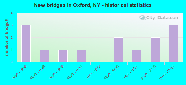
- New bridges - historical statistics
- 31930-1939
- 11940-1949
- 11950-1959
- 11960-1969
- 21980-1989
- 11990-1999
- 22000-2009
- 32010-2019
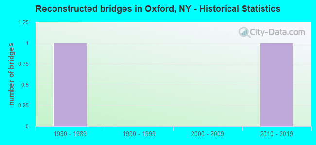
- Reconstructed bridges - Historical Statistics
- 11980-1989
- 01990-1999
- 02000-2009
- 12010-2019
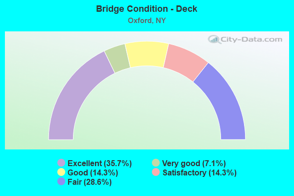
- Bridge Condition - Deck
- 35.7%Excellent
- 7.1%Very good
- 14.3%Good
- 14.3%Satisfactory
- 28.6%Fair
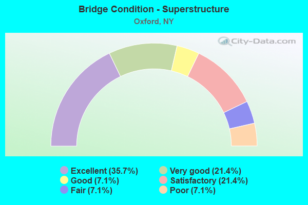
- Bridge Condition - Superstructure
- 35.7%Excellent
- 21.4%Very good
- 7.1%Good
- 21.4%Satisfactory
- 7.1%Fair
- 7.1%Poor
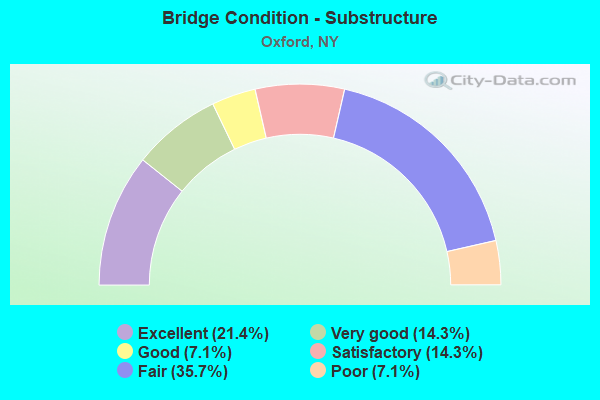
- Bridge Condition - Substructure
- 21.4%Excellent
- 14.3%Very good
- 7.1%Good
- 14.3%Satisfactory
- 35.7%Fair
- 7.1%Poor
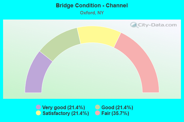
- Bridge Condition - Channel
- 21.4%Very good
- 21.4%Good
- 21.4%Satisfactory
- 35.7%Fair
Find on map >> Show street view
Structure Number: 100931, Location: 3.9 MI SW JCT RT 12 + 220 (Lat: 42.403053, Lng: -75.635192), Route carried "on" structure: State highway 12, Year Built: 2019, Status: Open, Structure Length: 2.80m (9.19ft), Average Daily Traffic: 3,881 (year 2020), Truck Traffic: 14%, Average Future Daily Traffic: 3,917 (year 2040), Design Load: HL 93, Features Intersected: BOWMAN CREEK
Minimum Vertical Clearance: 32.69m (107.25ft), Kilometerpoint: 27.176, Lanes on structure: 2, Owner: State Highway Agency, Approaching Roadway Width: 12.2m (40.0ft), Skew: 3 degrees, Material/Design: Steel, Design/Construction: Stringer/Multi-beam, Number Of Spans In Main Unit: 1, Length of Maximum Span: 27.4m (89.9ft), Curb-To-Curb Width: 12.2m (40.0ft), Out-to-Out Width: 13.2m (43.3ft)
Condition: Deck: Excellent, Superstructure: Excellent, Substructure: Excellent, Channel: Very good, Operating Rating: 63.5 metric tons, Method Used To Determine Operating Rating: Load Factor (LF), Inventory Rating: 38.1 metric tons, Method Used To Determine Inventory Rating: Load Factor (LF), Structural Evaluation: Superior to present desirable criteria, Deck Geometry: Equal to present minimum criteria, Waterway Adequacy: Somewhat better than minimum adequacy, Approach Roadway Alignment: Equal to present desirable criteria, Length Of Structure Improvement: 2.80m (9.19ft), Designated Inspection Frequency: Every 24 months, Inspection Date: October 2021, Bridge Improvement Cost: $1,063,000, Roadway Improvement Cost: $622,000, Total Project Cost: $1,685,000 ( Estimate for 2021), Deck Structure Type: Concrete Cast-file-Place, Wearing Surface/Protective System: Wearing Surface: Integral Concrete, Deck Protection: Epoxy Coated Reinforcing
Find on map >> Show street view
Structure Number: 100932, Location: 1.7 MI SW JCT RT 12 + 220 (Lat: 42.428789, Lng: -75.623569), Route carried "on" structure: State highway 12, Year Built: 1937, Year Reconstructed: 1993, Status: Open, Structure Length: 1.31m (4.30ft), Average Daily Traffic: 5,247 (year 2018), Truck Traffic: 8%, Average Future Daily Traffic: 5,296 (year 2040), Design Load: H 20, Features Intersected: MILL BROOK
Minimum Vertical Clearance: 30+ m (98+ ft), Kilometerpoint: 30.732, Lanes on structure: 2, Base Highway Network: Yes, Owner: State Highway Agency, Approaching Roadway Width: 11.6m (38.1ft), Skew: 1 degrees, Material/Design: Steel, Design/Construction: Stringer/Multi-beam, Number Of Spans In Main Unit: 1, Length of Maximum Span: 12.1m (39.7ft), Curb-To-Curb Width: 12.6m (41.3ft), Out-to-Out Width: 13.2m (43.3ft)
Condition: Deck: Satisfactory, Superstructure: Satisfactory, Substructure: Poor, Channel: Fair, Operating Rating: 89.8 metric tons, Method Used To Determine Operating Rating: Load Factor (LF), Inventory Rating: 53.5 metric tons, Method Used To Determine Inventory Rating: Load Factor (LF), Structural Evaluation: Meets minimum limits, Deck Geometry: Somewhat better than minimum adequacy, Waterway Adequacy: Equal to present desirable criteria, Approach Roadway Alignment: Equal to present desirable criteria, Length Of Structure Improvement: 1.31m (4.30ft), Designated Inspection Frequency: Every 24 months, Inspection Date: April 2020, Bridge Improvement Cost: $617,000, Roadway Improvement Cost: $361,000, Total Project Cost: $978,000 ( Estimate for 2021), Deck Structure Type: Concrete Cast-file-Place, Wearing Surface/Protective System: Wearing Surface: Integral Concrete, Deck Protection: Epoxy Coated Reinforcing
Find on map >> Show street view
Structure Number: 100933, Location: 1.8 MI NE JCT RT 12 + 220 (Lat: 42.460856, Lng: -75.574342), Route carried "on" structure: State highway 12, Year Built: 1947, Year Reconstructed: 2018, Status: Open, Structure Length: 2.93m (9.61ft), Average Daily Traffic: 6,069 (year 2020), Truck Traffic: 9%, Average Future Daily Traffic: 6,126 (year 2040), Design Load: H 20, Features Intersected: FLY MEADOW CREEK
Minimum Vertical Clearance: 30+ m (98+ ft), Kilometerpoint: 36.219, Lanes on structure: 2, Base Highway Network: Yes, Owner: State Highway Agency, Approaching Roadway Width: 10.1m (33.1ft), Material/Design: Steel, Design/Construction: Stringer/Multi-beam, Number Of Spans In Main Unit: 1, Length of Maximum Span: 28.0m (91.9ft), Curb-To-Curb Width: 10.1m (33.1ft), Out-to-Out Width: 11.2m (36.7ft)
Condition: Deck: Excellent, Superstructure: Very good, Substructure: Very good, Channel: Good, Operating Rating: 94.3 metric tons, Method Used To Determine Operating Rating: Load Factor (LF), Inventory Rating: 56.2 metric tons, Method Used To Determine Inventory Rating: Load Factor (LF), Structural Evaluation: Equal to present desirable criteria, Deck Geometry: Meets minimum limits, Waterway Adequacy: Equal to present desirable criteria, Approach Roadway Alignment: Equal to present desirable criteria, Length Of Structure Improvement: 2.92m (9.58ft), Designated Inspection Frequency: Every 24 months, Inspection Date: October 2020, Bridge Improvement Cost: $944,000, Roadway Improvement Cost: $553,000, Total Project Cost: $1,497,000 ( Estimate for 2021), Deck Structure Type: Concrete Precast Panels, Wearing Surface/Protective System: Wearing Surface: Latex Concrete
Find on map >> Show street view
Structure Number: 104174, Location: Main St & Chenango Rvr (Lat: 42.441567, Lng: -75.596478), Route carried "on" structure: County highway , Year Built: 2012, Status: Open, Structure Length: 6.25m (20.51ft), Average Daily Traffic: 2,262 (year 2018), Truck Traffic: 6%, Average Future Daily Traffic: 3,167 (year 2038), Design Load: HL 93, Features Intersected: CHENANGO RIVER, Facility Carried by Structure: MAIN STREET
Minimum Vertical Clearance: 30+ m (98+ ft), Kilometerpoint: 0.080, Lanes on structure: 2, Owner: County Highway Agency, Approaching Roadway Width: 9.1m (29.9ft), Skew: 1 degrees, Material/Design: Steel continuous, Design/Construction: Stringer/Multi-beam, Number Of Spans In Main Unit: 2, Length of Maximum Span: 30.5m (100.1ft), Curb or Sidewalk Widths: Left: 1.5m (4.9ft), Right: 1.5m (4.9ft), Curb-To-Curb Width: 9.2m (30.2ft), Out-to-Out Width: 13.9m (45.6ft)
Condition: Deck: Excellent, Superstructure: Excellent, Substructure: Excellent, Channel: Very good, Operating Rating: 66.2 metric tons, Method Used To Determine Operating Rating: Load Factor (LF), Inventory Rating: 39.9 metric tons, Method Used To Determine Inventory Rating: Load Factor (LF), Structural Evaluation: Superior to present desirable criteria, Deck Geometry: Meets minimum limits, Waterway Adequacy: Equal to present minimum criteria, Approach Roadway Alignment: Equal to present desirable criteria, Length Of Structure Improvement: 6.24m (20.47ft), Designated Inspection Frequency: Every 24 months, Inspection Date: September 2020, Bridge Improvement Cost: $2,196,000, Roadway Improvement Cost: $1,286,000, Total Project Cost: $3,483,000 ( Estimate for 2021), Deck Structure Type: Concrete Cast-file-Place, Wearing Surface/Protective System: Wearing Surface: Integral Concrete, Deck Protection: Epoxy Coated Reinforcing
Find on map >> Show street view
Structure Number: 107252, Location: JCT SH 220 & CHENANGO RI (Lat: 42.446419, Lng: -75.583906), Route carried "on" structure: State highway 220, Year Built: 1982, Status: Open, Structure Length: 18.29m (60.01ft), Average Daily Traffic: 2,917 (year 2019), Truck Traffic: 11%, Average Future Daily Traffic: 3,043 (year 2040), Design Load: HS 20, Features Intersected: NY SUSQ & WESTERN RR, CH
Minimum Vertical Clearance: 30+ m (98+ ft), Kilometerpoint: 32.309, Lanes on structure: 2, Base Highway Network: Yes, Owner: State Highway Agency, Approaching Roadway Width: 12.5m (41.0ft), Material/Design: Steel continuous, Design/Construction: Stringer/Multi-beam, Number Of Spans In Main Unit: 4, Length of Maximum Span: 51.2m (168.0ft), Curb-To-Curb Width: 11.0m (36.1ft), Out-to-Out Width: 12.1m (39.7ft)
Condition: Deck: Good, Superstructure: Very good, Substructure: Satisfactory, Channel: Fair, Operating Rating: 61.7 metric tons, Method Used To Determine Operating Rating: Load Testing, Inventory Rating: 37.2 metric tons, Method Used To Determine Inventory Rating: Load Testing, Structural Evaluation: Equal to present minimum criteria, Deck Geometry: Somewhat better than minimum adequacy, Underclear: Equal to present minimum criteria, Waterway Adequacy: Somewhat better than minimum adequacy, Approach Roadway Alignment: Equal to present desirable criteria, Length Of Structure Improvement: 18.28m (59.97ft), Designated Inspection Frequency: Every 24 months, Inspection Date: June 2020, Bridge Improvement Cost: $4,771,000, Roadway Improvement Cost: $2,794,000, Total Project Cost: $7,565,000 ( Estimate for 2021), Deck Structure Type: Concrete Cast-file-Place, Wearing Surface/Protective System: Wearing Surface: Integral Concrete, Deck Protection: Epoxy Coated Reinforcing
Find on map >> Show street view
Structure Number: 335051, Location: 1.5 MI E OF SOUTH OXFORD (Lat: 42.384217, Lng: -75.583608), Route carried "on" structure: County highway , Year Built: 1997, Status: Open, Structure Length: 1.52m (4.99ft), Average Daily Traffic: 583 (year 2017), Truck Traffic: 8%, Average Future Daily Traffic: 816 (year 2037), Design Load: HS 20, Features Intersected: BEAR BROOK, Facility Carried by Structure: COUNTY ROAD 27
Minimum Vertical Clearance: 30+ m (98+ ft), Kilometerpoint: 8.109, Lanes on structure: 2, Owner: County Highway Agency, Approaching Roadway Width: 7.9m (25.9ft), Material/Design: Steel, Design/Construction: Stringer/Multi-beam, Number Of Spans In Main Unit: 1, Length of Maximum Span: 14.6m (47.9ft), Curb-To-Curb Width: 8.7m (28.5ft), Out-to-Out Width: 9.2m (30.2ft)
Condition: Deck: Fair, Superstructure: Fair, Substructure: Fair, Channel: Fair, Inventory Rating: 61.7 metric tons, Method Used To Determine Inventory Rating: Load Factor (LF), Structural Evaluation: Somewhat better than minimum adequacy, Deck Geometry: Somewhat better than minimum adequacy, Waterway Adequacy: Meets minimum limits, Approach Roadway Alignment: Better than present minimum criteria, Length Of Structure Improvement: 1.52m (4.99ft), Designated Inspection Frequency: Every 24 months, Inspection Date: March 2021, Bridge Improvement Cost: $653,000, Roadway Improvement Cost: $382,000, Total Project Cost: $1,035,000 ( Estimate for 2021), Deck Structure Type: Corrugated Steel, Wearing Surface/Protective System: Wearing Surface: Bituminous
Find on map >> Show street view
Structure Number: 335058, Location: 3.7 MI SO OF OXFORD (Lat: 42.388506, Lng: -75.624611), Route carried "on" structure: County highway , Year Built: 2004, Status: Open, Structure Length: 1.22m (4.00ft), Average Daily Traffic: 1,216 (year 2017), Truck Traffic: 7%, Average Future Daily Traffic: 1,702 (year 2037), Design Load: HS 25 or greater, Features Intersected: BEAR BROOK, Facility Carried by Structure: COUNTY ROAD 32
Minimum Vertical Clearance: 30+ m (98+ ft), Kilometerpoint: 14.272, Lanes on structure: 2, Owner: County Highway Agency, Approaching Roadway Width: 9.1m (29.9ft), Material/Design: Prestressed concrete, Design/Construction: Box Beam or Girders - Multiple, Number Of Spans In Main Unit: 1, Length of Maximum Span: 11.5m (37.7ft), Curb-To-Curb Width: 8.8m (28.9ft), Out-to-Out Width: 9.2m (30.2ft)
Condition: Deck: Excellent, Superstructure: Excellent, Substructure: Satisfactory, Channel: Satisfactory, Operating Rating: 70.8 metric tons, Method Used To Determine Operating Rating: Load Factor (LF), Inventory Rating: 41.7 metric tons, Method Used To Determine Inventory Rating: Load Factor (LF), Structural Evaluation: Equal to present minimum criteria, Deck Geometry: Somewhat better than minimum adequacy, Waterway Adequacy: Meets minimum limits, Approach Roadway Alignment: Equal to present desirable criteria, Length Of Structure Improvement: 1.21m (3.97ft), Designated Inspection Frequency: Every 24 months, Inspection Date: August 2020, Bridge Improvement Cost: $518,000, Roadway Improvement Cost: $303,000, Total Project Cost: $822,000 ( Estimate for 2021), Wearing Surface/Protective System: Wearing Surface: Bituminous
Find on map >> Show street view
Structure Number: 335059, Location: 3.6 MILES SOUTH OF OXFORD (Lat: 42.389392, Lng: -75.624300), Route carried "on" structure: County highway , Year Built: 1938, Status: Open, Structure Length: 0.76m (2.49ft), Average Daily Traffic: 1,216 (year 2017), Truck Traffic: 7%, Average Future Daily Traffic: 1,702 (year 2037), Design Load: HS 25 or greater, Features Intersected: EDDY BROOK, Facility Carried by Structure: COUNTY ROAD 32
Minimum Vertical Clearance: 30+ m (98+ ft), Kilometerpoint: 14.384, Lanes on structure: 2, Owner: County Highway Agency, Approaching Roadway Width: 7.6m (24.9ft), Material/Design: Prestressed concrete, Design/Construction: Box Beam or Girders - Multiple, Number Of Spans In Main Unit: 1, Length of Maximum Span: 6.7m (22.0ft), Curb-To-Curb Width: 9.0m (29.5ft), Out-to-Out Width: 9.2m (30.2ft)
Condition: Deck: Very good, Superstructure: Very good, Substructure: Fair, Channel: Good, Operating Rating: 84.4 metric tons, Method Used To Determine Operating Rating: Load Factor (LF), Inventory Rating: 49.9 metric tons, Method Used To Determine Inventory Rating: Load Factor (LF), Structural Evaluation: Somewhat better than minimum adequacy, Deck Geometry: Somewhat better than minimum adequacy, Waterway Adequacy: Somewhat better than minimum adequacy, Approach Roadway Alignment: Equal to present desirable criteria, Length Of Structure Improvement: 0.76m (2.49ft), Designated Inspection Frequency: Every 24 months, Inspection Date: April 2021, Bridge Improvement Cost: $286,000, Roadway Improvement Cost: $167,000, Total Project Cost: $453,000 ( Estimate for 2021), Wearing Surface/Protective System: Wearing Surface: Bituminous
Find on map >> Show street view
Structure Number: 33506, Location: 3.1 MI SO OF OXFORD (Lat: 42.401167, Lng: -75.630222), Route carried "on" structure: Other road , Year Built: 1980, Status: Posted for load, Structure Length: 4.21m (13.81ft), Average Daily Traffic: 307 (year 2018), Truck Traffic: 8%, Average Future Daily Traffic: 430 (year 2038), Design Load: HS 15, Features Intersected: CHENANGO RIVER, Facility Carried by Structure: SOUTH OXFORD BRDGE
Minimum Vertical Clearance: 30+ m (98+ ft), Kilometerpoint: 0.290, Lanes on structure: 2, Owner: County Highway Agency, Approaching Roadway Width: 8.5m (27.9ft), Material/Design: Steel, Design/Construction: Girder and Floorbeam System, Number Of Spans In Main Unit: 1, Length of Maximum Span: 41.7m (136.8ft), Curb-To-Curb Width: 7.3m (24.0ft), Out-to-Out Width: 8.6m (28.2ft)
Condition: Deck: Fair, Superstructure: Good, Substructure: Good, Channel: Satisfactory, Operating Rating: 32.7 metric tons, Method Used To Determine Operating Rating: Load Factor (LF), Inventory Rating: 20.0 metric tons, Method Used To Determine Inventory Rating: Load Factor (LF), Structural Evaluation: Somewhat better than minimum adequacy, Deck Geometry: Somewhat better than minimum adequacy, Waterway Adequacy: Somewhat better than minimum adequacy, Approach Roadway Alignment: Equal to present desirable criteria, Bridge Posting: Required (Relationship of Operating Rating to Maximum Legal Load: > 39.9% below), Length Of Structure Improvement: 4.20m (13.78ft), Designated Inspection Frequency: Every 12 months, Critical Feature Inspection Frequency: Every 12 months, Inspection Date: August 2021, Critical Feature Inspection Date: August 2021, Bridge Improvement Cost: $798,000, Roadway Improvement Cost: $467,000, Total Project Cost: $1,265,000 ( Estimate for 2021), Deck Structure Type: Corrugated Steel, Wearing Surface/Protective System: Wearing Surface: Bituminous
Find on map >> Show street view
Structure Number: 335061, Location: 2.7 MI NE OF OXFORD (Lat: 42.462964, Lng: -75.548128), Route carried "on" structure: County highway , Year Built: 1955, Status: Open, Structure Length: 1.07m (3.51ft), Average Daily Traffic: 2,690 (year 2017), Truck Traffic: 8%, Average Future Daily Traffic: 3,766 (year 2037), Design Load: HS 20, Features Intersected: LYON BROOK, Facility Carried by Structure: COUNTY ROAD 32
Minimum Vertical Clearance: 30+ m (98+ ft), Kilometerpoint: 2.928, Lanes on structure: 2, Owner: County Highway Agency, Approaching Roadway Width: 7.9m (25.9ft), Skew: 3 degrees, Material/Design: Steel, Design/Construction: Stringer/Multi-beam, Number Of Spans In Main Unit: 1, Length of Maximum Span: 10.3m (33.8ft), Curb or Sidewalk Widths: Left: 0.3m (1.0ft), Right: 0.0m, Curb-To-Curb Width: 7.7m (25.3ft), Out-to-Out Width: 8.8m (28.9ft)
Condition: Deck: Fair, Superstructure: Poor, Substructure: Fair, Channel: Satisfactory, Operating Rating: 61.7 metric tons, Method Used To Determine Operating Rating: Load Factor (LF), Inventory Rating: 36.3 metric tons, Method Used To Determine Inventory Rating: Load Factor (LF), Structural Evaluation: Meets minimum limits, Deck Geometry: High priority of replacement, Waterway Adequacy: Meets minimum limits, Approach Roadway Alignment: Equal to present desirable criteria, Length Of Structure Improvement: 1.06m (3.48ft), Designated Inspection Frequency: Every 24 months, Inspection Date: June 2020, Bridge Improvement Cost: $359,000, Roadway Improvement Cost: $210,000, Total Project Cost: $569,000 ( Estimate for 2021), Deck Structure Type: Concrete Cast-file-Place, Wearing Surface/Protective System: Wearing Surface: Bituminous
Find on map >> Show street view
Structure Number: 335064, Location: 3.1 MI NE OF OXFORD (Lat: 42.458817, Lng: -75.535258), Route carried "on" structure: Other road , Year Built: 1937, Status: Open, Structure Length: 1.13m (3.71ft), Average Daily Traffic: 520 (year 2016), Truck Traffic: 5%, Average Future Daily Traffic: 728 (year 2036), Features Intersected: LYON BROOK, Facility Carried by Structure: LYON BROOK ROAD
Minimum Vertical Clearance: 30+ m (98+ ft), Kilometerpoint: 1.287, Lanes on structure: 2, Owner: County Highway Agency, Approaching Roadway Width: 6.1m (20.0ft), Skew: 4 degrees, Material/Design: Steel, Design/Construction: Stringer/Multi-beam, Number Of Spans In Main Unit: 1, Length of Maximum Span: 10.6m (34.8ft), Curb-To-Curb Width: 7.4m (24.3ft), Out-to-Out Width: 8.5m (27.9ft)
Condition: Deck: Fair, Superstructure: Satisfactory, Substructure: Fair, Channel: Fair, Operating Rating: 42.6 metric tons, Method Used To Determine Operating Rating: Load Factor (LF), Inventory Rating: 25.4 metric tons, Method Used To Determine Inventory Rating: Load Factor (LF), Structural Evaluation: Somewhat better than minimum adequacy, Deck Geometry: Meets minimum limits, Waterway Adequacy: Meets minimum limits, Approach Roadway Alignment: Equal to present desirable criteria, Length Of Structure Improvement: 1.12m (3.67ft), Designated Inspection Frequency: Every 24 months, Inspection Date: September 2020, Bridge Improvement Cost: $405,000, Roadway Improvement Cost: $237,000, Total Project Cost: $642,000 ( Estimate for 2021), Deck Structure Type: Concrete Cast-file-Place, Wearing Surface/Protective System: Wearing Surface: Bituminous
Find on map >> Show street view
Structure Number: 335065, Location: 2.9 MI NE OF OXFORD (Lat: 42.457936, Lng: -75.539744), Route carried "on" structure: Other road , Year Built: 1966, Status: Open, Structure Length: 1.28m (4.20ft), Average Daily Traffic: 520 (year 2016), Truck Traffic: 5%, Average Future Daily Traffic: 728 (year 2036), Features Intersected: LYON BROOK, Facility Carried by Structure: LYON BROOK ROAD
Minimum Vertical Clearance: 30+ m (98+ ft), Kilometerpoint: 0.901, Lanes on structure: 2, Owner: County Highway Agency, Approaching Roadway Width: 6.1m (20.0ft), Skew: 4 degrees, Material/Design: Steel, Design/Construction: Stringer/Multi-beam, Number Of Spans In Main Unit: 1, Length of Maximum Span: 11.8m (38.7ft), Curb-To-Curb Width: 7.3m (24.0ft), Out-to-Out Width: 7.5m (24.6ft)
Condition: Deck: Satisfactory, Superstructure: Satisfactory, Substructure: Fair, Channel: Fair, Operating Rating: 98.9 metric tons, Method Used To Determine Operating Rating: Load Factor (LF), Inventory Rating: 59.0 metric tons, Method Used To Determine Inventory Rating: Load Factor (LF), Structural Evaluation: Somewhat better than minimum adequacy, Deck Geometry: Meets minimum limits, Waterway Adequacy: Meets minimum limits, Approach Roadway Alignment: Meets minimum limits, Length Of Structure Improvement: 1.28m (4.20ft), Designated Inspection Frequency: Every 24 months, Inspection Date: September 2020, Bridge Improvement Cost: $393,000, Roadway Improvement Cost: $230,000, Total Project Cost: $623,000 ( Estimate for 2021), Deck Structure Type: Concrete Cast-file-Place, Wearing Surface/Protective System: Wearing Surface: Bituminous
Find on map >> Show street view
Structure Number: 335066, Location: 1 MI W OF OXFORD (Lat: 42.448117, Lng: -75.625789), Route carried "on" structure: Other road , Year Built: 2014, Status: Open, Structure Length: 1.40m (4.59ft), Average Daily Traffic: 169 (year 2016), Truck Traffic: 4%, Average Future Daily Traffic: 237 (year 2036), Design Load: HS 25 or greater, Features Intersected: MILL BROOK, Facility Carried by Structure: JOE HOBEN ROAD
Minimum Vertical Clearance: 30+ m (98+ ft), Kilometerpoint: 3.170, Lanes on structure: 2, Owner: County Highway Agency, Approaching Roadway Width: 7.6m (24.9ft), Material/Design: Prestressed concrete, Design/Construction: Box Beam or Girders - Multiple, Number Of Spans In Main Unit: 1, Length of Maximum Span: 13.4m (44.0ft), Curb-To-Curb Width: 7.9m (25.9ft), Out-to-Out Width: 8.7m (28.5ft)
Condition: Deck: Excellent, Superstructure: Excellent, Substructure: Excellent, Channel: Good, Operating Rating: 85.7 metric tons, Method Used To Determine Operating Rating: Load Factor (LF), Inventory Rating: 51.3 metric tons, Method Used To Determine Inventory Rating: Load Factor (LF), Structural Evaluation: Superior to present desirable criteria, Deck Geometry: Somewhat better than minimum adequacy, Waterway Adequacy: Equal to present minimum criteria, Approach Roadway Alignment: Equal to present desirable criteria, Length Of Structure Improvement: 1.40m (4.59ft), Designated Inspection Frequency: Every 24 months, Inspection Date: August 2020, Bridge Improvement Cost: $479,000, Roadway Improvement Cost: $280,000, Total Project Cost: $759,000 ( Estimate for 2021), Wearing Surface/Protective System: Wearing Surface: Bituminous
Find on map >> Show street view
Structure Number: 335077, Location: 4.5 MILES S OF NORWICH (Lat: 42.472747, Lng: -75.545319), Route carried "on" structure: County highway , Year Built: 2008, Status: Open, Structure Length: 5.55m (18.21ft), Average Daily Traffic: 1,542 (year 2015), Truck Traffic: 7%, Average Future Daily Traffic: 1,907 (year 2040), Features Intersected: CHENANGO RIVER, Facility Carried by Structure: COUNTY ROAD 32B
Minimum Vertical Clearance: 30+ m (98+ ft), Kilometerpoint: 0.048, Lanes on structure: 2, Owner: County Highway Agency, Approaching Roadway Width: 10.7m (35.1ft), Skew: 3 degrees, Material/Design: Steel continuous, Design/Construction: Stringer/Multi-beam, Number Of Spans In Main Unit: 2, Length of Maximum Span: 26.8m (87.9ft), Curb-To-Curb Width: 10.8m (35.4ft), Out-to-Out Width: 11.9m (39.0ft)
Condition: Deck: Good, Superstructure: Excellent, Substructure: Very good, Channel: Very good, Operating Rating: 82.4 metric tons, Method Used To Determine Operating Rating: Load Factor (LF), Inventory Rating: 49.4 metric tons, Method Used To Determine Inventory Rating: Load Factor (LF), Structural Evaluation: Equal to present desirable criteria, Deck Geometry: Equal to present minimum criteria, Waterway Adequacy: Equal to present minimum criteria, Approach Roadway Alignment: Equal to present desirable criteria, Length Of Structure Improvement: 5.54m (18.18ft), Designated Inspection Frequency: Every 24 months, Inspection Date: August 2020, Bridge Improvement Cost: $1,883,000, Roadway Improvement Cost: $1,103,000, Total Project Cost: $2,986,000 ( Estimate for 2021), Deck Structure Type: Concrete Cast-file-Place, Wearing Surface/Protective System: Wearing Surface: Integral Concrete, Deck Protection: Epoxy Coated Reinforcing