Bridge Statistics for Ozark, Missouri (MO)
Condition, Traffic, Stress, Structural Evaluation, Project Costs
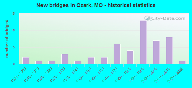
- New bridges - historical statistics
- 21900-1909
- 11910-1919
- 11920-1929
- 31930-1939
- 11940-1949
- 21950-1959
- 21960-1969
- 61970-1979
- 41980-1989
- 131990-1999
- 72000-2009
- 82010-2019
- 12020-2022
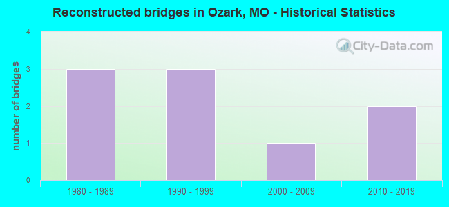
- Reconstructed bridges - Historical Statistics
- 31980-1989
- 31990-1999
- 12000-2009
- 22010-2019
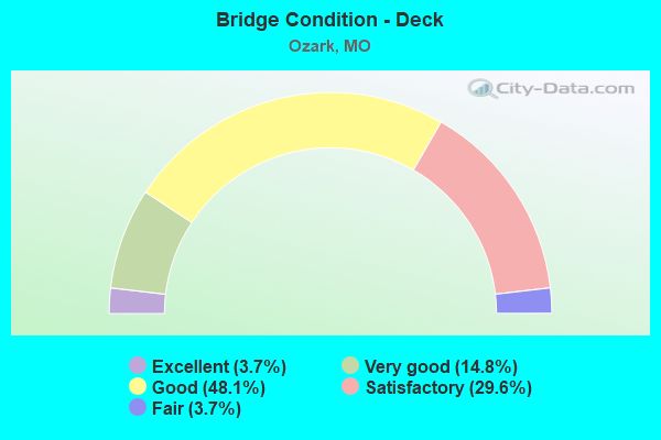
- Bridge Condition - Deck
- 3.7%Excellent
- 14.8%Very good
- 48.1%Good
- 29.6%Satisfactory
- 3.7%Fair
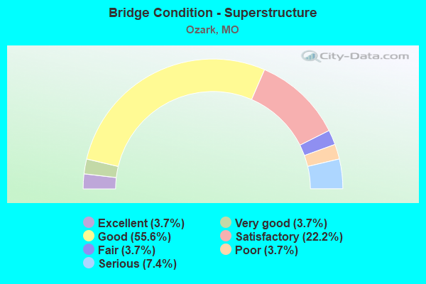
- Bridge Condition - Superstructure
- 3.7%Excellent
- 3.7%Very good
- 55.6%Good
- 22.2%Satisfactory
- 3.7%Fair
- 3.7%Poor
- 7.4%Serious
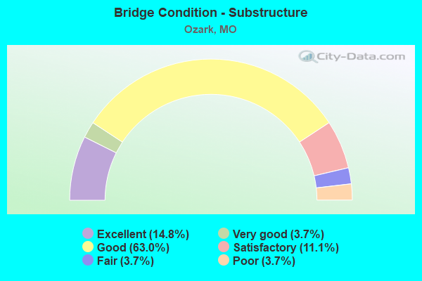
- Bridge Condition - Substructure
- 14.8%Excellent
- 3.7%Very good
- 63.0%Good
- 11.1%Satisfactory
- 3.7%Fair
- 3.7%Poor
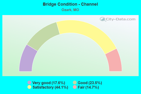
- Bridge Condition - Channel
- 17.6%Very good
- 23.5%Good
- 44.1%Satisfactory
- 14.7%Fair
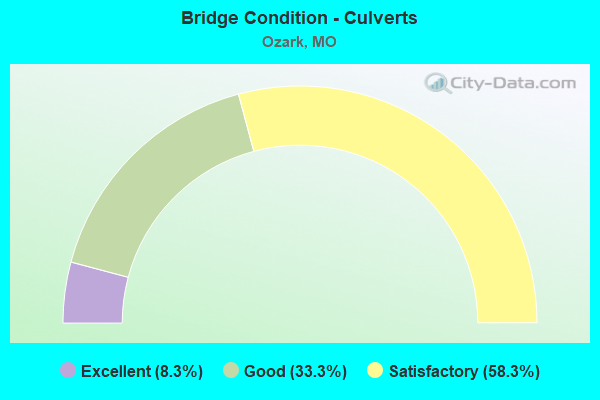
- Bridge Condition - Culverts
- 8.3%Excellent
- 33.3%Good
- 58.3%Satisfactory
Find on map >> Show street view
Structure Number: 19571, Location: S 4 T 27 N R 21 W (Lat: 37.071783, Lng: -93.237236), Route carried "on" structure: County highway 225, Year Built: 1900, Year Reconstructed: 1993, Status: Open, Structure Length: 0.79m (2.59ft), Average Daily Traffic: 100 (year 2021), Truck Traffic: 10%, Average Future Daily Traffic: 180 (year 2041), Features Intersected: BR OF JAMES RVR, Facility Carried by Structure: N 25TH ST
Minimum Vertical Clearance: 30+ m (98+ ft), Kilometerpoint: 1.107, Lanes on structure: 2, Owner: County Highway Agency, Approaching Roadway Width: 6.1m (20.0ft), Material/Design: Concrete continuous, Design/Construction: Slab, Number Of Spans In Main Unit: 2, Length of Maximum Span: 3.4m (11.2ft), Curb or Sidewalk Widths: Left: 0.4m (1.3ft), Right: 0.4m (1.3ft), Curb-To-Curb Width: 7.5m (24.6ft), Out-to-Out Width: 8.3m (27.2ft)
Condition: Deck: Good, Superstructure: Good, Substructure: Good, Channel: Fair, Operating Rating: 41.4 metric tons, Method Used To Determine Operating Rating: Allowable Stress (AS), Inventory Rating: 24.3 metric tons, Method Used To Determine Inventory Rating: Allowable Stress (AS), Structural Evaluation: Equal to present minimum criteria, Deck Geometry: Equal to present minimum criteria, Waterway Adequacy: Better than present minimum criteria, Approach Roadway Alignment: Equal to present desirable criteria, Designated Inspection Frequency: Every 24 months, Inspection Date: January 2021, Deck Structure Type: Concrete Cast-file-Place, Wearing Surface/Protective System: Wearing Surface: Bituminous
Find on map >> Show street view
Structure Number: 19664, Location: S 33 T 28 N R 21 W (Lat: 37.091008, Lng: -93.229936), Route carried "on" structure: County highway 229, Year Built: 1929, Year Reconstructed: 1996, Status: Open, Structure Length: 1.31m (4.30ft), Average Daily Traffic: 1,000 (year 2021), Truck Traffic: 10%, Average Future Daily Traffic: 1,800 (year 2041), Design Load: HS 20, Features Intersected: BR OF JAMES RVR, Facility Carried by Structure: FARMER BRANCH AVE
Minimum Vertical Clearance: 30+ m (98+ ft), Kilometerpoint: 0.154, Lanes on structure: 2, Owner: County Highway Agency, Maintenance Responsibility: Town or Township Highway Agency, Approaching Roadway Width: 6.4m (21.0ft), Material/Design: Concrete, Design/Construction: Stringer/Multi-beam, Number Of Spans In Main Unit: 1, Length of Maximum Span: 12.2m (40.0ft), Curb-To-Curb Width: 8.7m (28.5ft), Out-to-Out Width: 9.7m (31.8ft)
Condition: Deck: Satisfactory, Superstructure: Fair, Substructure: Satisfactory, Channel: Satisfactory, Operating Rating: 46.8 metric tons, Method Used To Determine Operating Rating: Allowable Stress (AS), Inventory Rating: 25.2 metric tons, Method Used To Determine Inventory Rating: Allowable Stress (AS), Structural Evaluation: Somewhat better than minimum adequacy, Deck Geometry: Somewhat better than minimum adequacy, Waterway Adequacy: Better than present minimum criteria, Approach Roadway Alignment: Equal to present desirable criteria, Designated Inspection Frequency: Every 24 months, Inspection Date: January 2021, Deck Structure Type: Concrete Cast-file-Place, Wearing Surface/Protective System: Wearing Surface: Bituminous
Find on map >> Show street view
Structure Number: 20123, Location: S 7 T 27 N R 20 W (Lat: 37.051667, Lng: -93.158333), Route carried "on" structure: County highway 248, Year Built: 1995, Status: Open, Structure Length: 2.51m (8.23ft), Average Daily Traffic: 200 (year 2021), Truck Traffic: 10%, Average Future Daily Traffic: 400 (year 2041), Features Intersected: BR OF FINLEY CR, Facility Carried by Structure: SMYRNA RD
Minimum Vertical Clearance: 30+ m (98+ ft), Kilometerpoint: 1.463, Lanes on structure: 2, Owner: County Highway Agency, Approaching Roadway Width: 6.1m (20.0ft), Skew: 5 degrees, Material/Design: Concrete continuous, Design/Construction: Slab, Number Of Spans In Main Unit: 4, Length of Maximum Span: 6.1m (20.0ft), Curb-To-Curb Width: 6.7m (22.0ft), Out-to-Out Width: 6.7m (22.0ft)
Condition: Deck: Satisfactory, Superstructure: Satisfactory, Substructure: Good, Channel: Satisfactory, Operating Rating: 32.4 metric tons, Method Used To Determine Operating Rating: Allowable Stress (AS), Inventory Rating: 18.9 metric tons, Method Used To Determine Inventory Rating: Allowable Stress (AS), Structural Evaluation: Somewhat better than minimum adequacy, Deck Geometry: Meets minimum limits, Waterway Adequacy: Equal to present minimum criteria, Approach Roadway Alignment: Equal to present desirable criteria, Designated Inspection Frequency: Every 24 months, Inspection Date: January 2021, Deck Structure Type: Concrete Cast-file-Place
Find on map >> Show street view
Structure Number: 20128, Location: S 7 T 27 N R 20 W (Lat: 37.049808, Lng: -93.162200), Route carried "on" structure: County highway 248, Year Built: 1995, Status: Open, Structure Length: 3.11m (10.20ft), Average Daily Traffic: 200 (year 2021), Truck Traffic: 10%, Average Future Daily Traffic: 400 (year 2041), Features Intersected: BR OF FINLEY CR, Facility Carried by Structure: SMYRNA RD
Minimum Vertical Clearance: 30+ m (98+ ft), Kilometerpoint: 1.043, Lanes on structure: 2, Owner: County Highway Agency, Approaching Roadway Width: 6.1m (20.0ft), Skew: 4 degrees, Material/Design: Concrete continuous, Design/Construction: Slab, Number Of Spans In Main Unit: 5, Length of Maximum Span: 6.1m (20.0ft), Curb-To-Curb Width: 6.7m (22.0ft), Out-to-Out Width: 6.7m (22.0ft)
Condition: Deck: Satisfactory, Superstructure: Satisfactory, Substructure: Good, Channel: Good, Operating Rating: 32.4 metric tons, Method Used To Determine Operating Rating: Allowable Stress (AS), Inventory Rating: 18.9 metric tons, Method Used To Determine Inventory Rating: Allowable Stress (AS), Structural Evaluation: Somewhat better than minimum adequacy, Deck Geometry: Meets minimum limits, Waterway Adequacy: Somewhat better than minimum adequacy, Approach Roadway Alignment: Equal to present minimum criteria, Designated Inspection Frequency: Every 24 months, Inspection Date: January 2021, Deck Structure Type: Concrete Cast-file-Place
Find on map >> Show street view
Structure Number: 20153, Location: S 18 T 27 N R 20 W (Lat: 37.037086, Lng: -93.171233), Route carried "on" structure: County highway 249, Year Built: 1912, Year Reconstructed: 2004, Status: Posted for load, Structure Length: 8.56m (28.08ft), Average Daily Traffic: 300 (year 2021), Truck Traffic: 10%, Average Future Daily Traffic: 600 (year 2041), Features Intersected: FINLEY RVR, Facility Carried by Structure: SMYRNA RD
Minimum Vertical Clearance: 4.52m (14.83ft), Kilometerpoint: 0.629, Lanes on structure: 1, Owner: County Highway Agency, Approaching Roadway Width: 5.5m (18.0ft), Material/Design: Steel, Design/Construction: Truss - Thru, Number Of Spans In Main Unit: 1, Number Of Approach Spans: 5, Length of Maximum Span: 36.3m (119.1ft), Curb-To-Curb Width: 3.6m (11.8ft), Out-to-Out Width: 3.7m (12.1ft)
Condition: Deck: Good, Superstructure: Serious, Substructure: Fair, Channel: Satisfactory, Operating Rating: 6.3 metric tons, Method Used To Determine Operating Rating: Field evaluation and documented engineering judgment, Inventory Rating: 2.7 metric tons, Method Used To Determine Inventory Rating: Field evaluation and documented engineering judgment, Structural Evaluation: High priority of replacement, Deck Geometry: High priority of replacement, Waterway Adequacy: Better than present minimum criteria, Approach Roadway Alignment: Meets minimum limits, Bridge Posting: Required (Relationship of Operating Rating to Maximum Legal Load: > 39.9% below), Length Of Structure Improvement: 0.95m (3.12ft), Designated Inspection Frequency: Every 24 months, Critical Feature Inspection Frequency: Every 24 months, Inspection Date: January 2021, Critical Feature Inspection Date: June 2021, Bridge Improvement Cost: $861,000, Roadway Improvement Cost: $86,000, Total Project Cost: $1,291,000 ( Estimate for 2022), Deck Structure Type: Closed Grating, Wearing Surface/Protective System: Wearing Surface: Bituminous
Find on map >> Show street view
Structure Number: 21884, Location: S 23 T 27 N R 21 W (Lat: 37.027214, Lng: -93.207300), Route carried "on" structure: City street , Year Built: 1900, Status: Posted for load, Structure Length: 6.22m (20.41ft), Average Daily Traffic: 1,500 (year 2021), Truck Traffic: 10%, Average Future Daily Traffic: 2,700 (year 2041), Features Intersected: FINLEY RVR, Facility Carried by Structure: MCCRACKEN RD
Minimum Vertical Clearance: 4.29m (14.07ft), Kilometerpoint: 0.307, Lanes on structure: 2, Owner: County Highway Agency, Maintenance Responsibility: City or Municipal Highway Agency, Approaching Roadway Width: 5.5m (18.0ft), Material/Design: Steel, Design/Construction: Truss - Thru, Number Of Spans In Main Unit: 2, Length of Maximum Span: 29.9m (98.1ft), Curb-To-Curb Width: 5.5m (18.0ft), Out-to-Out Width: 5.8m (19.0ft)
Condition: Deck: Fair, Superstructure: Serious, Substructure: Poor, Channel: Good, Operating Rating: 15.3 metric tons, Method Used To Determine Operating Rating: Load Factor (LF), Inventory Rating: 9.0 metric tons, Method Used To Determine Inventory Rating: Load Factor (LF), Structural Evaluation: High priority of replacement, Deck Geometry: High priority of replacement, Waterway Adequacy: Better than present minimum criteria, Approach Roadway Alignment: Equal to present minimum criteria, Bridge Posting: Required (Relationship of Operating Rating to Maximum Legal Load: 30.0 - 39.9% below), Length Of Structure Improvement: 0.73m (2.40ft), Designated Inspection Frequency: Every 24 months, Critical Feature Inspection Frequency: Every 24 months, Underwater Inspection Frequency: Every 60 months, Inspection Date: January 2021, Critical Feature Inspection Date: November 2020, Underwater Inspection Date: May 2019, Bridge Improvement Cost: $792,000, Roadway Improvement Cost: $79,000, Total Project Cost: $1,188,000 ( Estimate for 2022), Deck Structure Type: Concrete Cast-file-Place, Wearing Surface/Protective System: Wearing Surface: Bituminous
Find on map >> Show street view
Structure Number: 21885, Location: S 22 T 27 N R 21 W (Lat: 37.026981, Lng: -93.206236), Route carried "on" structure: City street , Year Built: 1942, Status: Open, Structure Length: 0.85m (2.79ft), Average Daily Traffic: 1,500 (year 2021), Truck Traffic: 10%, Average Future Daily Traffic: 2,700 (year 2041), Features Intersected: FINLEY RVR OVRFL, Facility Carried by Structure: W MCCRACKEN ST
Minimum Vertical Clearance: 30+ m (98+ ft), Kilometerpoint: 0.000, Lanes on structure: 2, Owner: County Highway Agency, Maintenance Responsibility: City or Municipal Highway Agency, Approaching Roadway Width: 7.9m (25.9ft), Material/Design: Concrete, Design/Construction: Culvert, Number Of Spans In Main Unit: 2, Length of Maximum Span: 4.3m (14.1ft), Curb-To-Curb Width: 17.1m (56.1ft), Out-to-Out Width: 17.7m (58.1ft)
Condition: Channel: Good, Culverts: Satisfactory, Operating Rating: 49.5 metric tons, Method Used To Determine Operating Rating: Allowable Stress (AS), Inventory Rating: 16.2 metric tons, Method Used To Determine Inventory Rating: Allowable Stress (AS), Structural Evaluation: Meets minimum limits, Deck Geometry: Superior to present desirable criteria, Waterway Adequacy: Better than present minimum criteria, Approach Roadway Alignment: Equal to present desirable criteria, Designated Inspection Frequency: Every 24 months, Inspection Date: January 2021, Deck Structure Type: Concrete Cast-file-Place, Wearing Surface/Protective System: Wearing Surface: Monolithic Concrete
Find on map >> Show street view
Structure Number: 2226, Location: S 3 T 26 N R 21 W (Lat: 36.986239, Lng: -93.224894), Route carried "on" structure: County highway , Year Built: 1932, Status: Open, Structure Length: 1.22m (4.00ft), Average Daily Traffic: 250 (year 2021), Truck Traffic: 10%, Average Future Daily Traffic: 500 (year 2041), Features Intersected: ELK VALLEY CR, Facility Carried by Structure: SELMORE RD
Minimum Vertical Clearance: 30+ m (98+ ft), Kilometerpoint: 0.000, Lanes on structure: 2, Owner: County Highway Agency, Approaching Roadway Width: 6.4m (21.0ft), Material/Design: Concrete, Design/Construction: Culvert, Number Of Spans In Main Unit: 3, Length of Maximum Span: 3.7m (12.1ft), Curb-To-Curb Width: 12.3m (40.4ft), Out-to-Out Width: 13.0m (42.7ft)
Condition: Channel: Satisfactory, Culverts: Satisfactory, Operating Rating: 49.5 metric tons, Method Used To Determine Operating Rating: Allowable Stress (AS), Inventory Rating: 16.2 metric tons, Method Used To Determine Inventory Rating: Allowable Stress (AS), Structural Evaluation: Somewhat better than minimum adequacy, Deck Geometry: Superior to present desirable criteria, Waterway Adequacy: Better than present minimum criteria, Approach Roadway Alignment: Equal to present desirable criteria, Designated Inspection Frequency: Every 24 months, Inspection Date: January 2021, Deck Structure Type: Concrete Cast-file-Place, Wearing Surface/Protective System: Wearing Surface: Bituminous
Find on map >> Show street view
Structure Number: 22591, Location: S 8 T 26 N R 21 W (Lat: 36.966869, Lng: -93.249569), Route carried "on" structure: County highway 363, Year Built: 1995, Status: Open, Structure Length: 0.76m (2.49ft), Average Daily Traffic: 50 (year 2021), Truck Traffic: 10%, Average Future Daily Traffic: 100 (year 2041), Features Intersected: HOG CR, Facility Carried by Structure: TENNESSEE RD
Minimum Vertical Clearance: 30+ m (98+ ft), Kilometerpoint: 4.019, Lanes on structure: 2, Owner: County Highway Agency, Approaching Roadway Width: 5.5m (18.0ft), Material/Design: Steel, Design/Construction: Stringer/Multi-beam, Number Of Spans In Main Unit: 1, Length of Maximum Span: 7.0m (23.0ft), Curb-To-Curb Width: 7.3m (24.0ft), Out-to-Out Width: 7.3m (24.0ft)
Condition: Deck: Good, Superstructure: Good, Substructure: Good, Channel: Satisfactory, Operating Rating: 51.3 metric tons, Method Used To Determine Operating Rating: Allowable Stress (AS), Inventory Rating: 30.6 metric tons, Method Used To Determine Inventory Rating: Allowable Stress (AS), Structural Evaluation: Better than present minimum criteria, Deck Geometry: Equal to present minimum criteria, Waterway Adequacy: Better than present minimum criteria, Approach Roadway Alignment: Equal to present desirable criteria, Designated Inspection Frequency: Every 24 months, Inspection Date: January 2021, Deck Structure Type: Concrete Cast-file-Place
Find on map >> Show street view
Structure Number: 23976, Location: S 2 T 28 N R 20 W (Lat: 36.988908, Lng: -93.202875), Route carried "on" structure: County highway 448, Year Built: 1995, Status: Open, Structure Length: 0.84m (2.76ft), Average Daily Traffic: 200 (year 2021), Truck Traffic: 10%, Average Future Daily Traffic: 400 (year 2041), Features Intersected: ELK VALLEY CR, Facility Carried by Structure: ELK VALLEY RD
Minimum Vertical Clearance: 30+ m (98+ ft), Kilometerpoint: 1.677, Lanes on structure: 2, Owner: County Highway Agency, Approaching Roadway Width: 7.3m (24.0ft), Material/Design: Concrete, Design/Construction: Slab, Number Of Spans In Main Unit: 2, Length of Maximum Span: 3.7m (12.1ft), Curb-To-Curb Width: 7.5m (24.6ft), Out-to-Out Width: 8.3m (27.2ft)
Condition: Deck: Good, Superstructure: Good, Substructure: Good, Channel: Satisfactory, Operating Rating: 41.4 metric tons, Method Used To Determine Operating Rating: Allowable Stress (AS), Inventory Rating: 24.3 metric tons, Method Used To Determine Inventory Rating: Allowable Stress (AS), Structural Evaluation: Equal to present minimum criteria, Deck Geometry: Somewhat better than minimum adequacy, Waterway Adequacy: Better than present minimum criteria, Approach Roadway Alignment: Equal to present desirable criteria, Designated Inspection Frequency: Every 24 months, Inspection Date: January 2021, Deck Structure Type: Concrete Cast-file-Place, Wearing Surface/Protective System: Wearing Surface: Bituminous
Find on map >> Show street view
Structure Number: 267, Location: S 33 T 28 N R 21 W (Lat: 37.091364, Lng: -93.231389), Route carried "on" structure: US 65, Year Built: 1977, Year Reconstructed: 2019, Status: Posted for load, Structure Length: 6.98m (22.90ft), Average Daily Traffic: 29,849 (year 2021), Truck Traffic: 18%, Average Future Daily Traffic: 52,236 (year 2041), Design Load: HS 20, Features Intersected: FARMERS BR
Minimum Vertical Clearance: 30+ m (98+ ft), Kilometerpoint: 434.612, Lanes on structure: 3, Base Highway Network: Yes, Owner: State Highway Agency, Approaching Roadway Width: 17.1m (56.1ft), Skew: 10 degrees, Material/Design: Steel continuous, Design/Construction: Stringer/Multi-beam, Number Of Spans In Main Unit: 3, Length of Maximum Span: 25.9m (85.0ft), Curb or Sidewalk Widths: Left: 0.0m, Right: 0.2m (0.7ft), Curb-To-Curb Width: 17.1m (56.1ft), Out-to-Out Width: 17.9m (58.7ft)
Condition: Deck: Good, Superstructure: Good, Substructure: Good, Channel: Very good, Operating Rating: 51.3 metric tons, Method Used To Determine Operating Rating: Load Factor (LF), Inventory Rating: 30.6 metric tons, Method Used To Determine Inventory Rating: Load Factor (LF), Structural Evaluation: Better than present minimum criteria, Deck Geometry: Equal to present minimum criteria, Waterway Adequacy: Equal to present desirable criteria, Approach Roadway Alignment: Equal to present desirable criteria, Designated Inspection Frequency: Every 24 months, Inspection Date: June 2020, Deck Structure Type: Concrete Cast-file-Place, Wearing Surface/Protective System: Wearing Surface: Other
Find on map >> Show street view
Structure Number: 2671, Location: S 22 T 27 N R 21 W (Lat: 37.023597, Lng: -93.228678), Route carried "on" structure: State highway 14, Year Built: 1977, Year Reconstructed: 2008, Status: Open, Structure Length: 8.25m (27.07ft), Average Daily Traffic: 13,466 (year 2021), Truck Traffic: 5%, Average Future Daily Traffic: 30,972 (year 2041), Design Load: HS 20, Features Intersected: US 65
Minimum Vertical Clearance: 30+ m (98+ ft), Kilometerpoint: 47.075, Lanes on structure: 6, Lanes under structure: 4, Base Highway Network: Yes, Owner: State Highway Agency, Approaching Roadway Width: 21.9m (71.9ft), Skew: 2 degrees, Material/Design: Steel continuous, Design/Construction: Stringer/Multi-beam, Number Of Spans In Main Unit: 2, Number Of Approach Spans: 2, Length of Maximum Span: 28.0m (91.9ft), Curb-To-Curb Width: 27.7m (90.9ft), Out-to-Out Width: 28.6m (93.8ft)
Condition: Deck: Good, Superstructure: Satisfactory, Substructure: Good, Operating Rating: 56.7 metric tons, Method Used To Determine Operating Rating: Load Factor (LF), Inventory Rating: 34.2 metric tons, Method Used To Determine Inventory Rating: Load Factor (LF), Structural Evaluation: Equal to present minimum criteria, Deck Geometry: Equal to present desirable criteria, Underclear: Somewhat better than minimum adequacy, Approach Roadway Alignment: Equal to present desirable criteria, Designated Inspection Frequency: Every 24 months, Other Special Inspection Frequency: Every 24 months, Inspection Date: June 2020, Other Special Inspection Date: October 2021, Deck Structure Type: Concrete Cast-file-Place, Wearing Surface/Protective System: Wearing Surface: Epoxy Overlay
Find on map >> Show street view
Structure Number: 2672, Location: S 28 T 27 N R 21 W (Lat: 37.016922, Lng: -93.229206), Route carried "on" structure: US 65, Year Built: 1977, Status: Posted for load, Structure Length: 9.48m (31.10ft), Average Daily Traffic: 22,490 (year 2021), Truck Traffic: 18%, Average Future Daily Traffic: 39,358 (year 2041), Design Load: HS 20, Features Intersected: FINLEY RVR
Minimum Vertical Clearance: 30+ m (98+ ft), Kilometerpoint: 442.860, Lanes on structure: 2, Base Highway Network: Yes, Owner: State Highway Agency, Approaching Roadway Width: 12.2m (40.0ft), Skew: 10 degrees, Material/Design: Steel continuous, Design/Construction: Stringer/Multi-beam, Number Of Spans In Main Unit: 4, Length of Maximum Span: 25.6m (84.0ft), Curb or Sidewalk Widths: Left: 0.2m (0.7ft), Right: 0.2m (0.7ft), Curb-To-Curb Width: 12.0m (39.4ft), Out-to-Out Width: 12.9m (42.3ft)
Condition: Deck: Satisfactory, Superstructure: Good, Substructure: Satisfactory, Channel: Satisfactory, Operating Rating: 54.9 metric tons, Method Used To Determine Operating Rating: Load Factor (LF), Inventory Rating: 32.4 metric tons, Method Used To Determine Inventory Rating: Load Factor (LF), Structural Evaluation: Equal to present minimum criteria, Deck Geometry: Equal to present minimum criteria, Waterway Adequacy: Equal to present desirable criteria, Approach Roadway Alignment: Equal to present desirable criteria, Designated Inspection Frequency: Every 24 months, Inspection Date: June 2020, Deck Structure Type: Concrete Cast-file-Place, Wearing Surface/Protective System: Wearing Surface: Bituminous, Deck Protection: Epoxy Coated Reinforcing
Find on map >> Show street view
Structure Number: 30139, Location: S 32 T 27 N R 21 W (Lat: 37.001744, Lng: -93.254231), Route carried "on" structure: State highway F, Year Built: 2004, Status: Open, Structure Length: 5.63m (18.47ft), Average Daily Traffic: 1,316 (year 2021), Truck Traffic: 5%, Average Future Daily Traffic: 2,566 (year 2041), Design Load: HS 20, Features Intersected: ELK CR
Minimum Vertical Clearance: 30+ m (98+ ft), Kilometerpoint: 2.158, Lanes on structure: 2, Owner: State Highway Agency, Approaching Roadway Width: 9.8m (32.2ft), Skew: 4 degrees, Material/Design: Prestressed concrete continuous, Design/Construction: Stringer/Multi-beam, Number Of Spans In Main Unit: 2, Length of Maximum Span: 28.2m (92.5ft), Curb-To-Curb Width: 9.8m (32.2ft), Out-to-Out Width: 10.6m (34.8ft)
Condition: Deck: Very good, Superstructure: Good, Substructure: Excellent, Channel: Fair, Operating Rating: 69.3 metric tons, Method Used To Determine Operating Rating: Load Factor (LF), Inventory Rating: 36.0 metric tons, Method Used To Determine Inventory Rating: Load Factor (LF), Structural Evaluation: Better than present minimum criteria, Deck Geometry: Somewhat better than minimum adequacy, Waterway Adequacy: Superior to present desirable criteria, Approach Roadway Alignment: Meets minimum limits, Designated Inspection Frequency: Every 24 months, Inspection Date: June 2020, Deck Structure Type: Concrete Cast-file-Place, Wearing Surface/Protective System: Wearing Surface: Monolithic Concrete, Deck Protection: Epoxy Coated Reinforcing
Find on map >> Show street view
Structure Number: 31275, Location: S 33 T 27 N R 21 W (Lat: 36.997222, Lng: -93.238858), Route carried "on" structure: County highway , Year Built: 2004, Status: Open, Structure Length: 2.19m (7.19ft), Average Daily Traffic: 200 (year 2021), Truck Traffic: 10%, Average Future Daily Traffic: 400 (year 2041), Design Load: HS 20, Features Intersected: ELK VALLEY CR, Facility Carried by Structure: CAVE HOLLOW RD
Minimum Vertical Clearance: 30+ m (98+ ft), Kilometerpoint: 0.000, Lanes on structure: 2, Owner: County Highway Agency, Approaching Roadway Width: 7.3m (24.0ft), Skew: 5 degrees, Material/Design: Steel, Design/Construction: Stringer/Multi-beam, Number Of Spans In Main Unit: 1, Length of Maximum Span: 21.0m (68.9ft), Curb-To-Curb Width: 7.2m (23.6ft), Out-to-Out Width: 7.3m (24.0ft)
Condition: Deck: Good, Superstructure: Good, Substructure: Good, Channel: Very good, Operating Rating: 85.5 metric tons, Method Used To Determine Operating Rating: Load Factor (LF), Inventory Rating: 51.3 metric tons, Method Used To Determine Inventory Rating: Load Factor (LF), Structural Evaluation: Better than present minimum criteria, Deck Geometry: Meets minimum limits, Waterway Adequacy: Better than present minimum criteria, Approach Roadway Alignment: Equal to present minimum criteria, Designated Inspection Frequency: Every 24 months, Inspection Date: January 2021, Deck Structure Type: Concrete Cast-file-Place, Wearing Surface/Protective System: Wearing Surface: Bituminous
Find on map >> Show street view
Structure Number: 31277, Location: S 18 T 27 N R 20 W (Lat: 37.042550, Lng: -93.169589), Route carried "on" structure: County highway 248, Year Built: 2003, Status: Open, Structure Length: 2.16m (7.09ft), Average Daily Traffic: 300 (year 2021), Truck Traffic: 10%, Average Future Daily Traffic: 600 (year 2041), Design Load: HS 20, Features Intersected: PARCHED CORN CR, Facility Carried by Structure: SMYRNA RD
Minimum Vertical Clearance: 30+ m (98+ ft), Kilometerpoint: 0.000, Lanes on structure: 2, Owner: County Highway Agency, Approaching Roadway Width: 6.7m (22.0ft), Skew: 4 degrees, Material/Design: Steel, Design/Construction: Stringer/Multi-beam, Number Of Spans In Main Unit: 1, Length of Maximum Span: 20.7m (67.9ft), Curb-To-Curb Width: 7.0m (23.0ft), Out-to-Out Width: 7.3m (24.0ft)
Condition: Deck: Good, Superstructure: Satisfactory, Substructure: Good, Channel: Fair, Operating Rating: 55.8 metric tons, Method Used To Determine Operating Rating: Load Factor (LF), Inventory Rating: 33.3 metric tons, Method Used To Determine Inventory Rating: Load Factor (LF), Structural Evaluation: Equal to present minimum criteria, Deck Geometry: Meets minimum limits, Waterway Adequacy: Better than present minimum criteria, Approach Roadway Alignment: Equal to present desirable criteria, Designated Inspection Frequency: Every 24 months, Inspection Date: January 2021, Deck Structure Type: Concrete Cast-file-Place
Find on map >> Show street view
Structure Number: 31278, Location: S 8 T 27 N R 20 W (Lat: 37.053986, Lng: -93.155331), Route carried "on" structure: County highway 277, Year Built: 2002, Status: Open, Structure Length: 1.23m (4.04ft), Average Daily Traffic: 100 (year 2021), Truck Traffic: 10%, Average Future Daily Traffic: 200 (year 2041), Features Intersected: BR OF FINLEY CR, Facility Carried by Structure: PARCH CORN RD
Minimum Vertical Clearance: 30+ m (98+ ft), Kilometerpoint: 0.000, Lanes on structure: 2, Owner: County Highway Agency, Approaching Roadway Width: 5.5m (18.0ft), Skew: 2 degrees, Material/Design: Concrete continuous, Design/Construction: Slab, Number Of Spans In Main Unit: 2, Length of Maximum Span: 5.5m (18.0ft), Curb-To-Curb Width: 7.9m (25.9ft), Out-to-Out Width: 7.9m (25.9ft)
Condition: Deck: Good, Superstructure: Good, Substructure: Good, Channel: Good, Operating Rating: 53.1 metric tons, Method Used To Determine Operating Rating: Load Factor (LF), Inventory Rating: 31.5 metric tons, Method Used To Determine Inventory Rating: Load Factor (LF), Structural Evaluation: Better than present minimum criteria, Deck Geometry: Equal to present minimum criteria, Waterway Adequacy: Equal to present minimum criteria, Approach Roadway Alignment: Equal to present minimum criteria, Designated Inspection Frequency: Every 24 months, Inspection Date: January 2021, Deck Structure Type: Concrete Cast-file-Place
Find on map >> Show street view
Structure Number: 3128, Location: S 2 T 39 N R 9 W (Lat: 38.146378, Lng: -91.882433), Route carried "on" structure: US 63, Year Built: 1978, Status: Open, Structure Length: 30.33m (99.51ft), Average Daily Traffic: 5,131 (year 2021), Truck Traffic: 13%, Average Future Daily Traffic: 8,979 (year 2041), Design Load: HS 20+Mod, Features Intersected: GASCONADE RVR
Minimum Vertical Clearance: 30+ m (98+ ft), Kilometerpoint: 309.680, Lanes on structure: 2, Base Highway Network: Yes, Owner: State Highway Agency, Approaching Roadway Width: 13.4m (44.0ft), Skew: 3 degrees, Material/Design: Steel continuous, Design/Construction: Stringer/Multi-beam, Number Of Spans In Main Unit: 3, Number Of Approach Spans: 9, Length of Maximum Span: 48.8m (160.1ft), Curb or Sidewalk Widths: Left: 0.2m (0.7ft), Right: 0.2m (0.7ft), Curb-To-Curb Width: 13.4m (44.0ft), Out-to-Out Width: 14.4m (47.2ft)
Condition: Deck: Satisfactory, Superstructure: Poor, Substructure: Satisfactory, Channel: Fair, Operating Rating: 46.8 metric tons, Method Used To Determine Operating Rating: Load Factor (LF), Inventory Rating: 27.9 metric tons, Method Used To Determine Inventory Rating: Load Factor (LF), Structural Evaluation: Meets minimum limits, Deck Geometry: Equal to present minimum criteria, Waterway Adequacy: Equal to present desirable criteria, Approach Roadway Alignment: Equal to present desirable criteria, Length Of Structure Improvement: 3.03m (9.94ft), Designated Inspection Frequency: Every 24 months, Underwater Inspection Frequency: Every 60 months, Inspection Date: July 2020, Underwater Inspection Date: August 2021, Bridge Improvement Cost: $3,627,000, Roadway Improvement Cost: $363,000, Total Project Cost: $5,440,000 ( Estimate for 2022), Deck Structure Type: Concrete Cast-file-Place, Wearing Surface/Protective System: Wearing Surface: Monolithic Concrete, Deck Protection: Epoxy Coated Reinforcing
Find on map >> Show street view
Structure Number: 3128, Location: S 3 T 27 N R 21 W (Lat: 37.072236, Lng: -93.219036), Route carried "on" structure: County highway 328, Year Built: 2003, Status: Open, Structure Length: 0.94m (3.08ft), Average Daily Traffic: 1,000 (year 2021), Truck Traffic: 10%, Average Future Daily Traffic: 1,800 (year 2041), Design Load: HS 20+Mod, Features Intersected: TRIB OF JAMES RVR, Facility Carried by Structure: FARMERS BRANCH RD
Minimum Vertical Clearance: 30+ m (98+ ft), Kilometerpoint: 0.000, Lanes on structure: 2, Owner: County Highway Agency, Approaching Roadway Width: 7.3m (24.0ft), Material/Design: Concrete continuous, Design/Construction: Culvert, Number Of Spans In Main Unit: 2, Length of Maximum Span: 4.6m (15.1ft)
Condition: Channel: Satisfactory, Culverts: Good, Operating Rating: 51.3 metric tons, Method Used To Determine Operating Rating: Load Factor (LF), Inventory Rating: 30.6 metric tons, Method Used To Determine Inventory Rating: Load Factor (LF), Structural Evaluation: Better than present minimum criteria, Waterway Adequacy: Better than present minimum criteria, Approach Roadway Alignment: Equal to present desirable criteria, Designated Inspection Frequency: Every 24 months, Inspection Date: January 2021
Find on map >> Show street view
Structure Number: 3156, Location: S 28 T 27 N R 21 W (Lat: 37.004883, Lng: -93.229675), Route carried "on" structure: State highway F, Year Built: 1996, Status: Open, Structure Length: 7.92m (25.98ft), Average Daily Traffic: 1,316 (year 2021), Truck Traffic: 5%, Average Future Daily Traffic: 3,027 (year 2041), Design Load: HS 20, Features Intersected: US 65
Minimum Vertical Clearance: 30+ m (98+ ft), Kilometerpoint: 4.765, Lanes on structure: 4, Lanes under structure: 4, Owner: State Highway Agency, Approaching Roadway Width: 6.1m (20.0ft), Skew: 30 degrees, Material/Design: Steel continuous, Design/Construction: Stringer/Multi-beam, Number Of Spans In Main Unit: 2, Length of Maximum Span: 33.8m (110.9ft), Curb or Sidewalk Widths: Left: 0.2m (0.7ft), Right: 0.2m (0.7ft), Curb-To-Curb Width: 19.8m (65.0ft), Out-to-Out Width: 21.8m (71.5ft)
Condition: Deck: Satisfactory, Superstructure: Very good, Substructure: Good, Operating Rating: 55.8 metric tons, Method Used To Determine Operating Rating: Load Factor (LF), Inventory Rating: 33.3 metric tons, Method Used To Determine Inventory Rating: Load Factor (LF), Structural Evaluation: Better than present minimum criteria, Deck Geometry: Better than present minimum criteria, Underclear: Equal to present minimum criteria, Approach Roadway Alignment: Equal to present desirable criteria, Designated Inspection Frequency: Every 24 months, Inspection Date: June 2020, Deck Structure Type: Concrete Cast-file-Place, Wearing Surface/Protective System: Wearing Surface: Monolithic Concrete, Deck Protection: Epoxy Coated Reinforcing
Find on map >> Show street view
Structure Number: 3157, Location: S 33 T 27 N R 21 W (Lat: 36.991444, Lng: -93.230508), Route carried "on" structure: US 65, Year Built: 1986, Status: Open, Structure Length: 8.41m (27.59ft), Average Daily Traffic: 14,870 (year 2021), Truck Traffic: 23%, Average Future Daily Traffic: 26,023 (year 2041), Design Load: HS 20+Mod, Features Intersected: ELK VALLEY CR
Minimum Vertical Clearance: 30+ m (98+ ft), Kilometerpoint: 445.718, Lanes on structure: 2, Base Highway Network: Yes, Owner: State Highway Agency, Approaching Roadway Width: 12.2m (40.0ft), Skew: 3 degrees, Material/Design: Prestressed concrete continuous, Design/Construction: Stringer/Multi-beam, Number Of Spans In Main Unit: 4, Length of Maximum Span: 22.6m (74.1ft), Curb or Sidewalk Widths: Left: 0.2m (0.7ft), Right: 0.2m (0.7ft), Curb-To-Curb Width: 11.8m (38.7ft), Out-to-Out Width: 12.6m (41.3ft)
Condition: Deck: Good, Superstructure: Satisfactory, Substructure: Good, Channel: Satisfactory, Operating Rating: 63.0 metric tons, Method Used To Determine Operating Rating: Load Factor (LF), Inventory Rating: 38.7 metric tons, Method Used To Determine Inventory Rating: Load Factor (LF), Structural Evaluation: Equal to present minimum criteria, Deck Geometry: Equal to present minimum criteria, Waterway Adequacy: Equal to present desirable criteria, Approach Roadway Alignment: Equal to present desirable criteria, Designated Inspection Frequency: Every 24 months, Inspection Date: June 2020, Deck Structure Type: Concrete Cast-file-Place, Wearing Surface/Protective System: Wearing Surface: Monolithic Concrete, Deck Protection: Epoxy Coated Reinforcing
Find on map >> Show street view
Structure Number: 3158, Location: S 9 T 26 N R 21 W (Lat: 36.973047, Lng: -93.231228), Route carried "on" structure: County highway , Year Built: 1996, Status: Open, Structure Length: 8.02m (26.31ft), Average Daily Traffic: 10 (year 2021), Truck Traffic: 10%, Average Future Daily Traffic: 20 (year 2041), Design Load: HS 20, Features Intersected: US 65, Facility Carried by Structure: SELMORE OVERPASS E
Minimum Vertical Clearance: 30+ m (98+ ft), Kilometerpoint: 0.043, Lanes on structure: 2, Lanes under structure: 4, Owner: State Highway Agency, Approaching Roadway Width: 6.1m (20.0ft), Material/Design: Steel continuous, Design/Construction: Stringer/Multi-beam, Number Of Spans In Main Unit: 2, Length of Maximum Span: 33.8m (110.9ft), Curb or Sidewalk Widths: Left: 0.2m (0.7ft), Right: 0.2m (0.7ft), Curb-To-Curb Width: 8.2m (26.9ft), Out-to-Out Width: 9.0m (29.5ft)
Condition: Deck: Good, Superstructure: Good, Substructure: Good, Operating Rating: 60.3 metric tons, Method Used To Determine Operating Rating: Load Factor (LF), Inventory Rating: 36.0 metric tons, Method Used To Determine Inventory Rating: Load Factor (LF), Structural Evaluation: Better than present minimum criteria, Deck Geometry: Equal to present minimum criteria, Underclear: Better than present minimum criteria, Approach Roadway Alignment: Equal to present desirable criteria, Designated Inspection Frequency: Every 24 months, Inspection Date: June 2020, Deck Structure Type: Concrete Cast-file-Place, Wearing Surface/Protective System: Wearing Surface: Monolithic Concrete, Deck Protection: Epoxy Coated Reinforcing
Find on map >> Show street view
Structure Number: 3159, Location: S 21 T 26 N R 21 W (Lat: 36.943111, Lng: -93.232008), Route carried "on" structure: State highway EE, Year Built: 1996, Status: Open, Structure Length: 7.89m (25.89ft), Average Daily Traffic: 5,676 (year 2021), Truck Traffic: 11%, Average Future Daily Traffic: 11,068 (year 2041), Design Load: HS 20, Features Intersected: US 65
Minimum Vertical Clearance: 30+ m (98+ ft), Kilometerpoint: 5.736, Lanes on structure: 3, Lanes under structure: 4, Owner: State Highway Agency, Approaching Roadway Width: 12.2m (40.0ft), Material/Design: Steel continuous, Design/Construction: Stringer/Multi-beam, Number Of Spans In Main Unit: 2, Length of Maximum Span: 33.8m (110.9ft), Curb or Sidewalk Widths: Left: 0.2m (0.7ft), Right: 0.2m (0.7ft), Curb-To-Curb Width: 16.1m (52.8ft), Out-to-Out Width: 18.1m (59.4ft)
Condition: Deck: Satisfactory, Superstructure: Good, Substructure: Good, Operating Rating: 61.2 metric tons, Method Used To Determine Operating Rating: Load Factor (LF), Inventory Rating: 36.9 metric tons, Method Used To Determine Inventory Rating: Load Factor (LF), Structural Evaluation: Better than present minimum criteria, Deck Geometry: Better than present minimum criteria, Underclear: Better than present minimum criteria, Approach Roadway Alignment: Equal to present desirable criteria, Designated Inspection Frequency: Every 24 months, Inspection Date: June 2020, Deck Structure Type: Concrete Cast-file-Place, Wearing Surface/Protective System: Wearing Surface: Monolithic Concrete, Deck Protection: Epoxy Coated Reinforcing
Find on map >> Show street view
Structure Number: 3201, Location: S 3 T 27 N R 21 W (Lat: 37.070069, Lng: -93.226139), Route carried "on" structure: State highway J, Year Built: 1987, Year Reconstructed: 2015, Status: Open, Structure Length: 0.64m (2.10ft), Average Daily Traffic: 13,697 (year 2021), Truck Traffic: 5%, Average Future Daily Traffic: 31,503 (year 2041), Design Load: HS 20, Features Intersected: TRIB OF JAMES RVR
Minimum Vertical Clearance: 30+ m (98+ ft), Kilometerpoint: 0.328, Lanes on structure: 5, Owner: State Highway Agency, Approaching Roadway Width: 13.4m (44.0ft), Skew: 3 degrees, Material/Design: Concrete continuous, Design/Construction: Culvert, Number Of Spans In Main Unit: 2, Length of Maximum Span: 2.4m (7.9ft)
Condition: Channel: Good, Culverts: Good, Structural Evaluation: Better than present minimum criteria, Waterway Adequacy: Equal to present minimum criteria, Approach Roadway Alignment: Equal to present desirable criteria, Designated Inspection Frequency: Every 24 months, Inspection Date: January 2021
Find on map >> Show street view
Structure Number: 3292, Location: S 16 T 27 N R 21 W (Lat: 37.044081, Lng: -93.246594), Route carried "on" structure: County highway , Year Built: 2000, Status: Open, Structure Length: 0.73m (2.40ft), Average Daily Traffic: 300 (year 2021), Truck Traffic: 10%, Average Future Daily Traffic: 540 (year 2041), Features Intersected: BR OF FINLEY RVR, Facility Carried by Structure: TREVOR TRL
Minimum Vertical Clearance: 30+ m (98+ ft), Kilometerpoint: 0.000, Lanes on structure: 2, Owner: City or Municipal Highway Agency, Approaching Roadway Width: 7.0m (23.0ft), Material/Design: Steel, Design/Construction: Culvert, Number Of Spans In Main Unit: 4, Length of Maximum Span: 1.5m (4.9ft), Curb-To-Curb Width: 7.0m (23.0ft), Out-to-Out Width: 7.3m (24.0ft)
Condition: Channel: Satisfactory, Culverts: Good, Operating Rating: 54.0 metric tons, Method Used To Determine Operating Rating: Load Factor (LF), Inventory Rating: 32.4 metric tons, Method Used To Determine Inventory Rating: Load Factor (LF), Structural Evaluation: Better than present minimum criteria, Deck Geometry: Meets minimum limits, Waterway Adequacy: Better than present minimum criteria, Approach Roadway Alignment: Equal to present desirable criteria, Designated Inspection Frequency: Every 24 months, Inspection Date: January 2021, Wearing Surface/Protective System: Wearing Surface: Bituminous
Find on map >> Show street view
Structure Number: 33551, Location: S 33 T 27 N R 21 W (Lat: 36.991669, Lng: -93.231669), Route carried "on" structure: County highway 194, Year Built: 2009, Status: Open, Structure Length: 2.13m (6.99ft), Average Daily Traffic: 150 (year 2021), Truck Traffic: 10%, Average Future Daily Traffic: 300 (year 2041), Features Intersected: ELK VALLEY CR, Facility Carried by Structure: RIVERDALE RD
Minimum Vertical Clearance: 30+ m (98+ ft), Kilometerpoint: 0.000, Lanes on structure: 2, Owner: County Highway Agency, Approaching Roadway Width: 6.1m (20.0ft), Skew: 2 degrees, Material/Design: Steel, Design/Construction: Stringer/Multi-beam, Number Of Spans In Main Unit: 1, Length of Maximum Span: 21.3m (69.9ft), Curb-To-Curb Width: 7.3m (24.0ft), Out-to-Out Width: 7.5m (24.6ft)
Condition: Deck: Good, Superstructure: Good, Substructure: Good, Channel: Very good, Operating Rating: 80.1 metric tons, Method Used To Determine Operating Rating: Load Factor (LF), Inventory Rating: 47.7 metric tons, Method Used To Determine Inventory Rating: Load Factor (LF), Structural Evaluation: Better than present minimum criteria, Deck Geometry: Somewhat better than minimum adequacy, Waterway Adequacy: Better than present minimum criteria, Approach Roadway Alignment: Better than present minimum criteria, Designated Inspection Frequency: Every 24 months, Inspection Date: January 2021, Deck Structure Type: Concrete Cast-file-Place, Wearing Surface/Protective System: Wearing Surface: Monolithic Concrete
Find on map >> Show street view
Structure Number: 34399, Location: S 33 T 28 N R 21 W (Lat: 37.091128, Lng: -93.231064), Route carried "on" structure: US 65, Year Built: 2014, Status: Open, Structure Length: 6.36m (20.87ft), Average Daily Traffic: 29,038 (year 2021), Truck Traffic: 10%, Average Future Daily Traffic: 50,817 (year 2041), Features Intersected: FARMERS BR
Minimum Vertical Clearance: 30+ m (98+ ft), Kilometerpoint: 69.120, Lanes on structure: 3, Base Highway Network: Yes, Owner: State Highway Agency, Approaching Roadway Width: 17.1m (56.1ft), Material/Design: Prestressed concrete continuous, Design/Construction: Tee Beam, Number Of Spans In Main Unit: 2, Length of Maximum Span: 34.1m (111.9ft), Curb-To-Curb Width: 20.1m (65.9ft), Out-to-Out Width: 20.8m (68.2ft)
Condition: Deck: Very good, Superstructure: Good, Substructure: Very good, Channel: Very good, Operating Rating: 75.6 metric tons, Method Used To Determine Operating Rating: Load Factor (LF), Inventory Rating: 35.1 metric tons, Method Used To Determine Inventory Rating: Load Factor (LF), Structural Evaluation: Better than present minimum criteria, Deck Geometry: Superior to present desirable criteria, Waterway Adequacy: Superior to present desirable criteria, Approach Roadway Alignment: Equal to present desirable criteria, Designated Inspection Frequency: Every 24 months, Inspection Date: June 2020, Deck Structure Type: Concrete Cast-file-Place, Wearing Surface/Protective System: Wearing Surface: Monolithic Concrete, Deck Protection: Other Coated Reinforcing
Find on map >> Show street view
Structure Number: 34823, Location: S 7 T 27 N R 20 W (Lat: 37.046750, Lng: -93.166361), Route carried "on" structure: County highway 248, Year Built: 2014, Status: Open, Structure Length: 2.44m (8.01ft), Average Daily Traffic: 200 (year 2021), Truck Traffic: 10%, Average Future Daily Traffic: 400 (year 2041), Design Load: HS 20, Features Intersected: BR OF FINLEY CR, Facility Carried by Structure: SMYRNA RD
Minimum Vertical Clearance: 30+ m (98+ ft), Kilometerpoint: 1.287, Lanes on structure: 2, Owner: County Highway Agency, Approaching Roadway Width: 6.9m (22.6ft), Skew: 3 degrees, Material/Design: Concrete continuous, Design/Construction: Slab, Number Of Spans In Main Unit: 2, Length of Maximum Span: 12.2m (40.0ft), Curb-To-Curb Width: 6.9m (22.6ft), Out-to-Out Width: 7.5m (24.6ft)
Condition: Deck: Good, Superstructure: Good, Substructure: Good, Channel: Very good, Operating Rating: 70.2 metric tons, Method Used To Determine Operating Rating: Load Factor (LF), Inventory Rating: 42.3 metric tons, Method Used To Determine Inventory Rating: Load Factor (LF), Structural Evaluation: Better than present minimum criteria, Deck Geometry: Meets minimum limits, Waterway Adequacy: Somewhat better than minimum adequacy, Approach Roadway Alignment: Equal to present minimum criteria, Designated Inspection Frequency: Every 24 months, Inspection Date: January 2021, Deck Structure Type: Concrete Precast Panels, Wearing Surface/Protective System: Wearing Surface: Monolithic Concrete
Find on map >> Show street view
Structure Number: 34911, Location: S 33 T 27 N R 21 W (Lat: 37.000778, Lng: -93.245778), Route carried "on" structure: County highway 191, Year Built: 2011, Status: Open, Structure Length: 1.31m (4.30ft), Average Daily Traffic: 200 (year 2021), Truck Traffic: 10%, Average Future Daily Traffic: 400 (year 2041), Design Load: HS 20, Features Intersected: ELK VALLEY CR, Facility Carried by Structure: TENNESSEE RD
Minimum Vertical Clearance: 30+ m (98+ ft), Kilometerpoint: 0.161, Lanes on structure: 2, Owner: County Highway Agency, Approaching Roadway Width: 4.9m (16.1ft), Skew: 3 degrees, Material/Design: Concrete continuous, Design/Construction: Culvert, Number Of Spans In Main Unit: 4, Length of Maximum Span: 2.4m (7.9ft)
Condition: Channel: Satisfactory, Culverts: Good, Operating Rating: 54.0 metric tons, Method Used To Determine Operating Rating: Field evaluation and documented engineering judgment, Inventory Rating: 32.4 metric tons, Method Used To Determine Inventory Rating: Field evaluation and documented engineering judgment, Structural Evaluation: Better than present minimum criteria, Waterway Adequacy: Meets minimum limits, Approach Roadway Alignment: Equal to present minimum criteria, Designated Inspection Frequency: Every 24 months, Inspection Date: January 2021, Deck Structure Type: Concrete Cast-file-Place, Wearing Surface/Protective System: Wearing Surface: Monolithic Concrete
Find on map >> Show street view
Structure Number: 35044, Location: S 3 T 27 N R 21 W (Lat: 37.070139, Lng: -93.228628), Route carried "on" structure: State highway J, Year Built: 2016, Status: Open, Structure Length: 6.94m (22.77ft), Average Daily Traffic: 7,092 (year 2021), Truck Traffic: 5%, Average Future Daily Traffic: 16,312 (year 2041), Features Intersected: US 65
Minimum Vertical Clearance: 30+ m (98+ ft), Kilometerpoint: 0.829, Lanes on structure: 2, Lanes under structure: 4, Owner: State Highway Agency, Approaching Roadway Width: 8.5m (27.9ft), Material/Design: Prestressed concrete, Design/Construction: Tee Beam, Number Of Spans In Main Unit: 2, Length of Maximum Span: 34.1m (111.9ft), Curb-To-Curb Width: 8.5m (27.9ft), Out-to-Out Width: 12.1m (39.7ft)
Condition: Deck: Very good, Superstructure: Good, Substructure: Excellent, Operating Rating: 61.2 metric tons, Method Used To Determine Operating Rating: Load Factor (LF), Inventory Rating: 29.7 metric tons, Method Used To Determine Inventory Rating: Load Factor (LF), Structural Evaluation: Better than present minimum criteria, Deck Geometry: High priority of corrective action, Underclear: Superior to present desirable criteria, Approach Roadway Alignment: Equal to present desirable criteria, Designated Inspection Frequency: Every 24 months, Inspection Date: June 2020, Deck Structure Type: Concrete Cast-file-Place, Wearing Surface/Protective System: Wearing Surface: Monolithic Concrete, Deck Protection: Epoxy Coated Reinforcing
Find on map >> Show street view
Structure Number: 36014, Location: S 5 T 27 N R 20 W (Lat: 37.062244, Lng: -93.146408), Route carried "on" structure: County highway 277, Year Built: 2017, Status: Open, Structure Length: 1.80m (5.91ft), Average Daily Traffic: 30 (year 2021), Truck Traffic: 10%, Average Future Daily Traffic: 60 (year 2041), Design Load: HS 20, Features Intersected: PARCH CORN CR, Facility Carried by Structure: PARCH CORN ROAD
Minimum Vertical Clearance: 30+ m (98+ ft), Kilometerpoint: 0.000, Lanes on structure: 2, Owner: County Highway Agency, Approaching Roadway Width: 7.3m (24.0ft), Skew: 1 degrees, Material/Design: Prestressed concrete, Design/Construction: Stringer/Multi-beam, Number Of Spans In Main Unit: 1, Length of Maximum Span: 17.1m (56.1ft), Curb-To-Curb Width: 7.3m (24.0ft), Out-to-Out Width: 8.1m (26.6ft)
Condition: Deck: Very good, Superstructure: Excellent, Substructure: Excellent, Channel: Good, Operating Rating: 64.8 metric tons, Method Used To Determine Operating Rating: Load Factor (LF), Inventory Rating: 49.5 metric tons, Method Used To Determine Inventory Rating: Load Factor (LF), Structural Evaluation: Superior to present desirable criteria, Deck Geometry: Equal to present minimum criteria, Waterway Adequacy: Equal to present desirable criteria, Approach Roadway Alignment: Equal to present minimum criteria, Designated Inspection Frequency: Every 24 months, Inspection Date: January 2021, Deck Structure Type: Concrete Cast-file-Place, Wearing Surface/Protective System: Deck Protection: Epoxy Coated Reinforcing
Find on map >> Show street view
Structure Number: 36018, Location: S 14 T 27 N R 21 W (Lat: 37.042853, Lng: -93.195444), Route carried "on" structure: County highway 209, Year Built: 2020, Status: Posted for load, Structure Length: 10.97m (35.99ft), Average Daily Traffic: 15,000 (year 2021), Truck Traffic: 10%, Average Future Daily Traffic: 30,000 (year 2041), Features Intersected: FINLEY RVR, Facility Carried by Structure: RIVERSIDE RD
Minimum Vertical Clearance: 30+ m (98+ ft), Kilometerpoint: 0.000, Lanes on structure: 2, Owner: Local Agency, Approaching Roadway Width: 7.3m (24.0ft), Material/Design: Prestressed concrete continuous, Design/Construction: Tee Beam, Number Of Spans In Main Unit: 3, Length of Maximum Span: 42.7m (140.1ft), Curb or Sidewalk Widths: Left: 3.0m (9.8ft), Right: 0.0m, Curb-To-Curb Width: 7.3m (24.0ft), Out-to-Out Width: 11.2m (36.7ft)
Condition: Deck: Excellent, Superstructure: Good, Substructure: Excellent, Channel: Very good, Operating Rating: 83.7 metric tons, Method Used To Determine Operating Rating: Load Factor (LF), Inventory Rating: 54.9 metric tons, Method Used To Determine Inventory Rating: Load Factor (LF), Structural Evaluation: Better than present minimum criteria, Deck Geometry: High priority of replacement, Waterway Adequacy: Equal to present desirable criteria, Approach Roadway Alignment: Equal to present desirable criteria, Designated Inspection Frequency: Every 24 months, Inspection Date: January 2021, Deck Structure Type: Concrete Cast-file-Place, Wearing Surface/Protective System: Wearing Surface: Monolithic Concrete, Deck Protection: Epoxy Coated Reinforcing
Find on map >> Show street view
Structure Number: 36166, Location: S 14 T 27 N R 21 W (Lat: 37.036861, Lng: -93.201103), Route carried "on" structure: County highway 209, Year Built: 2019, Status: Open, Structure Length: 0.72m (2.36ft), Average Daily Traffic: 1,500 (year 2021), Truck Traffic: 10%, Average Future Daily Traffic: 3,000 (year 2041), Design Load: HS 20, Features Intersected: BR OF FINLEY RVR, Facility Carried by Structure: RIVERSIDE RD
Minimum Vertical Clearance: 30+ m (98+ ft), Kilometerpoint: 7.001, Lanes on structure: 2, Owner: County Highway Agency, Approaching Roadway Width: 6.4m (21.0ft), Material/Design: Concrete, Design/Construction: Culvert, Number Of Spans In Main Unit: 3, Length of Maximum Span: 2.1m (6.9ft), Curb-To-Curb Width: 7.9m (25.9ft), Out-to-Out Width: 7.9m (25.9ft)
Condition: Channel: Good, Culverts: Excellent, Operating Rating: 50.4 metric tons, Method Used To Determine Operating Rating: Load Factor (LF), Inventory Rating: 29.7 metric tons, Method Used To Determine Inventory Rating: Load Factor (LF), Structural Evaluation: Better than present minimum criteria, Deck Geometry: Meets minimum limits, Waterway Adequacy: Better than present minimum criteria, Approach Roadway Alignment: Equal to present desirable criteria, Designated Inspection Frequency: Every 24 months, Inspection Date: January 2021
Find on map >> Show street view
Structure Number: 403, Location: S 16 T 26 N R 21 W (Lat: 36.952892, Lng: -93.231928), Route carried "on" structure: US 65, Year Built: 1960, Year Reconstructed: 1985, Status: Open, Structure Length: 1.07m (3.51ft), Average Daily Traffic: 29,997 (year 2021), Truck Traffic: 23%, Average Future Daily Traffic: 52,495 (year 2041), Design Load: H 20, Features Intersected: ELK VALLEY CR
Minimum Vertical Clearance: 30+ m (98+ ft), Kilometerpoint: 450.033, Lanes on structure: 4, Base Highway Network: Yes, Owner: State Highway Agency, Approaching Roadway Width: 39.0m (128.0ft), Skew: 4 degrees, Material/Design: Concrete continuous, Design/Construction: Culvert, Number Of Spans In Main Unit: 2, Length of Maximum Span: 3.7m (12.1ft)
Condition: Channel: Satisfactory, Culverts: Satisfactory, Operating Rating: 72.0 metric tons, Method Used To Determine Operating Rating: Field evaluation and documented engineering judgment, Inventory Rating: 43.2 metric tons, Method Used To Determine Inventory Rating: Field evaluation and documented engineering judgment, Structural Evaluation: Equal to present minimum criteria, Waterway Adequacy: Equal to present desirable criteria, Approach Roadway Alignment: Equal to present desirable criteria, Designated Inspection Frequency: Every 24 months, Inspection Date: January 2021
Find on map >> Show street view
Structure Number: 463, Location: S 3 T 27 N R 21 W (Lat: 37.067269, Lng: -93.228467), Route carried "on" structure: US 65, Year Built: 1959, Year Reconstructed: 1987, Status: Open, Structure Length: 0.82m (2.69ft), Average Daily Traffic: 46,718 (year 2021), Truck Traffic: 18%, Average Future Daily Traffic: 81,757 (year 2041), Design Load: HS 20, Features Intersected: TRIB OF JAMES RVR
Minimum Vertical Clearance: 30+ m (98+ ft), Kilometerpoint: 437.329, Lanes on structure: 5, Base Highway Network: Yes, Owner: State Highway Agency, Approaching Roadway Width: 39.0m (128.0ft), Skew: 24 degrees, Material/Design: Concrete continuous, Design/Construction: Culvert, Number Of Spans In Main Unit: 2, Length of Maximum Span: 3.0m (9.8ft)
Condition: Channel: Satisfactory, Culverts: Satisfactory, Operating Rating: 44.1 metric tons, Method Used To Determine Operating Rating: Load Factor (LF), Inventory Rating: 26.1 metric tons, Method Used To Determine Inventory Rating: Load Factor (LF), Structural Evaluation: Equal to present minimum criteria, Waterway Adequacy: Equal to present desirable criteria, Approach Roadway Alignment: Equal to present desirable criteria, Designated Inspection Frequency: Every 24 months, Inspection Date: January 2021
Find on map >> Show street view
Structure Number: 54, Location: S 20 T 27 N R 21 W (Lat: 37.026278, Lng: -93.248481), Route carried "on" structure: State highway 14, Year Built: 1931, Status: Open, Structure Length: 0.93m (3.05ft), Average Daily Traffic: 11,268 (year 2021), Truck Traffic: 8%, Average Future Daily Traffic: 25,916 (year 2041), Design Load: H 15, Features Intersected: SPRING BR
Minimum Vertical Clearance: 30+ m (98+ ft), Kilometerpoint: 45.179, Lanes on structure: 2, Base Highway Network: Yes, Owner: State Highway Agency, Approaching Roadway Width: 8.5m (27.9ft), Skew: 3 degrees, Material/Design: Concrete continuous, Design/Construction: Culvert, Number Of Spans In Main Unit: 2, Length of Maximum Span: 3.7m (12.1ft)
Condition: Channel: Fair, Culverts: Satisfactory, Operating Rating: 87.3 metric tons, Method Used To Determine Operating Rating: Load Factor (LF), Inventory Rating: 52.2 metric tons, Method Used To Determine Inventory Rating: Load Factor (LF), Structural Evaluation: Equal to present minimum criteria, Waterway Adequacy: Equal to present minimum criteria, Approach Roadway Alignment: Equal to present desirable criteria, Designated Inspection Frequency: Every 24 months, Inspection Date: January 2021
Find on map >> Show street view
Structure Number: 7159, Location: S 24 T 28 N R 21 W (Lat: 37.112436, Lng: -93.190211), Route carried "on" structure: State highway NN, Year Built: 1958, Status: Open, Structure Length: 1.20m (3.94ft), Average Daily Traffic: 2,995 (year 2021), Truck Traffic: 5%, Average Future Daily Traffic: 4,792 (year 2041), Design Load: H 10, Features Intersected: BR HUNT CR
Minimum Vertical Clearance: 30+ m (98+ ft), Kilometerpoint: 1.324, Lanes on structure: 2, Base Highway Network: Yes, Owner: State Highway Agency, Approaching Roadway Width: 7.3m (24.0ft), Skew: 3 degrees, Material/Design: Concrete continuous, Design/Construction: Culvert, Number Of Spans In Main Unit: 3, Length of Maximum Span: 3.4m (11.2ft), Curb-To-Curb Width: 9.4m (30.8ft), Out-to-Out Width: 10.0m (32.8ft)
Condition: Channel: Satisfactory, Culverts: Satisfactory, Operating Rating: 47.7 metric tons, Method Used To Determine Operating Rating: Load Factor (LF), Inventory Rating: 28.8 metric tons, Method Used To Determine Inventory Rating: Load Factor (LF), Structural Evaluation: Equal to present minimum criteria, Deck Geometry: Meets minimum limits, Waterway Adequacy: Equal to present minimum criteria, Approach Roadway Alignment: Meets minimum limits, Designated Inspection Frequency: Every 24 months, Inspection Date: January 2021
Find on map >> Show street view
Structure Number: 808, Location: S 22 T 27 N R 21 W (Lat: 37.024431, Lng: -93.207972), Route carried "on" structure: State highway 14, Year Built: 1962, Year Reconstructed: 2003, Status: Posted for load, Structure Length: 11.37m (37.30ft), Average Daily Traffic: 12,822 (year 2021), Truck Traffic: 10%, Average Future Daily Traffic: 29,491 (year 2041), Design Load: H 20, Features Intersected: FINLEY CR
Minimum Vertical Clearance: 30+ m (98+ ft), Kilometerpoint: 48.931, Lanes on structure: 2, Owner: State Highway Agency, Approaching Roadway Width: 13.4m (44.0ft), Skew: 3 degrees, Material/Design: Steel continuous, Design/Construction: Stringer/Multi-beam, Number Of Spans In Main Unit: 4, Length of Maximum Span: 31.7m (104.0ft), Curb or Sidewalk Widths: Left: 0.4m (1.3ft), Right: 2.2m (7.2ft), Curb-To-Curb Width: 13.4m (44.0ft), Out-to-Out Width: 16.0m (52.5ft)
Condition: Deck: Satisfactory, Superstructure: Satisfactory, Substructure: Good, Channel: Satisfactory, Operating Rating: 39.6 metric tons, Method Used To Determine Operating Rating: Load Factor (LF), Inventory Rating: 23.4 metric tons, Method Used To Determine Inventory Rating: Load Factor (LF), Structural Evaluation: Somewhat better than minimum adequacy, Deck Geometry: Equal to present minimum criteria, Waterway Adequacy: Equal to present desirable criteria, Approach Roadway Alignment: Equal to present minimum criteria, Designated Inspection Frequency: Every 24 months, Inspection Date: January 2022, Deck Structure Type: Concrete Cast-file-Place, Wearing Surface/Protective System: Wearing Surface: Monolithic Concrete, Deck Protection: Epoxy Coated Reinforcing
Find on map >> Show street view
Structure Number: 9372, Location: S 36 T 27 N R 21 W (Lat: 37.000022, Lng: -93.174983), Route carried "on" structure: State highway W, Year Built: 1937, Status: Open, Structure Length: 0.65m (2.13ft), Average Daily Traffic: 2,744 (year 2021), Truck Traffic: 9%, Average Future Daily Traffic: 5,351 (year 2041), Design Load: H 10, Features Intersected: DRY BR
Minimum Vertical Clearance: 30+ m (98+ ft), Kilometerpoint: 0.341, Lanes on structure: 2, Owner: State Highway Agency, Approaching Roadway Width: 8.5m (27.9ft), Skew: 1 degrees, Material/Design: Concrete continuous, Design/Construction: Culvert, Number Of Spans In Main Unit: 2, Length of Maximum Span: 3.0m (9.8ft), Curb-To-Curb Width: 8.4m (27.6ft), Out-to-Out Width: 9.0m (29.5ft)
Condition: Channel: Good, Culverts: Satisfactory, Operating Rating: 57.6 metric tons, Method Used To Determine Operating Rating: Load Factor (LF), Inventory Rating: 34.2 metric tons, Method Used To Determine Inventory Rating: Load Factor (LF), Structural Evaluation: Equal to present minimum criteria, Deck Geometry: High priority of corrective action, Waterway Adequacy: Equal to present minimum criteria, Approach Roadway Alignment: Equal to present desirable criteria, Length Of Structure Improvement: 0.13m (0.43ft), Designated Inspection Frequency: Every 24 months, Inspection Date: January 2021, Bridge Improvement Cost: $170,000, Roadway Improvement Cost: $17,000, Total Project Cost: $255,000 ( Estimate for 2022)
Find on map >> Show street view
Structure Number: 2671, Location: S 22 T 27 N R 21 W (Lat: 37.023597, Lng: -93.228678), Route carried "under" structure: US 65, Year Built: 1977, Structure Length: 0. m, Average Daily Traffic: 23,026 (year 2021), Truck Traffic: 10%, Features Intersected: US 65, Facility Carried by Structure: MO 14 E
Minimum Vertical Clearance: 4.95m (16.24ft), Kilometerpoint: 61.624, Lanes on structure: 6, Lanes under structure: 2, Material/Design: Steel continuous, Design/Construction: Stringer/Multi-beam, Length of Maximum Span: 28.0m (91.9ft)
Find on map >> Show street view
Structure Number: 2671, Location: S 22 T 27 N R 21 W (Lat: 37.023597, Lng: -93.228678), Route carried "under" structure: US 65, Year Built: 1977, Structure Length: 0. m, Average Daily Traffic: 23,478 (year 2021), Truck Traffic: 18%, Features Intersected: US 65, Facility Carried by Structure: MO 14 E
Minimum Vertical Clearance: 5.41m (17.75ft), Kilometerpoint: 442.215, Lanes on structure: 6, Lanes under structure: 2, Material/Design: Steel continuous, Design/Construction: Stringer/Multi-beam, Length of Maximum Span: 28.0m (91.9ft)
Find on map >> Show street view
Structure Number: 3156, Location: S 28 T 27 N R 21 W (Lat: 37.004883, Lng: -93.229675), Route carried "under" structure: US 65, Year Built: 1996, Structure Length: 0. m, Average Daily Traffic: 14,870 (year 2021), Truck Traffic: 23%, Features Intersected: US 65, Facility Carried by Structure: RT F E
Minimum Vertical Clearance: 5.06m (16.60ft), Kilometerpoint: 444.273, Lanes on structure: 4, Lanes under structure: 2, Material/Design: Steel continuous, Design/Construction: Stringer/Multi-beam, Length of Maximum Span: 33.8m (110.9ft)
Find on map >> Show street view
Structure Number: 3156, Location: S 28 T 27 N R 21 W (Lat: 37.004883, Lng: -93.229675), Route carried "under" structure: US 65, Year Built: 1996, Structure Length: 0. m, Average Daily Traffic: 15,127 (year 2021), Truck Traffic: 6%, Features Intersected: US 65, Facility Carried by Structure: RT F E
Minimum Vertical Clearance: 5.51m (18.08ft), Kilometerpoint: 59.551, Lanes on structure: 4, Lanes under structure: 2, Material/Design: Steel continuous, Design/Construction: Stringer/Multi-beam, Length of Maximum Span: 33.8m (110.9ft)
Find on map >> Show street view
Structure Number: 3158, Location: S 9 T 26 N R 21 W (Lat: 36.973047, Lng: -93.231228), Route carried "under" structure: US 65, Year Built: 1996, Structure Length: 0. m, Average Daily Traffic: 14,870 (year 2021), Truck Traffic: 23%, Features Intersected: US 65, Facility Carried by Structure: SELMORE OVERPASS E
Minimum Vertical Clearance: 5.82m (19.09ft), Kilometerpoint: 447.802, Lanes on structure: 2, Lanes under structure: 2, Material/Design: Steel continuous, Design/Construction: Stringer/Multi-beam, Length of Maximum Span: 33.8m (110.9ft)
Find on map >> Show street view
Structure Number: 3158, Location: S 9 T 26 N R 21 W (Lat: 36.973047, Lng: -93.231228), Route carried "under" structure: US 65, Year Built: 1996, Structure Length: 0. m, Average Daily Traffic: 15,127 (year 2021), Truck Traffic: 6%, Features Intersected: US 65, Facility Carried by Structure: SELMORE OVERPASS E
Minimum Vertical Clearance: 5.11m (16.77ft), Kilometerpoint: 56.020, Lanes on structure: 2, Lanes under structure: 2, Material/Design: Steel continuous, Design/Construction: Stringer/Multi-beam, Length of Maximum Span: 33.8m (110.9ft)